

4.1 Philippines Government Contact List
Further information on the Departmen of Public Works and Highways can be found in the following document:
Philippines Road
Assessment Additional Information
Distance Matrix
|
Distances from Capital City to Major Towns (km) |
||||||||
|---|---|---|---|---|---|---|---|---|
|
|
Manila |
Baguio |
San Fernando, La Union |
Laoag City, Illocos Norte |
Tuguegarao, Cagayan |
Bontoc, Mountain Province |
Pagsanjan, Laguna |
Legazpi City, Bicol |
|
Manila |
|
246 |
264 |
477 |
483 |
394 |
102 |
538 |
|
Baguio |
246 |
|
47 |
254 |
230 |
101 |
308 |
711 |
|
San Fernando, La Union |
264 |
47 |
|
406 |
408 |
274 |
335 |
540 |
|
Laoag City, Illocos Norte |
477 |
254 |
406 |
|
180 |
230 |
550 |
975 |
|
Tuguegarao, Cagayan |
483 |
230 |
408 |
180 |
|
130 |
526 |
964 |
|
Bontoc, Mountain Province |
394 |
101 |
274 |
230 |
130 |
|
416 |
842 |
|
Pagsanjan, Laguna |
102 |
308 |
335 |
550 |
526 |
416 |
|
403 |
|
Legazpi City, Bicol |
538 |
711 |
540 |
975 |
964 |
842 |
403 |
|
Travel Time Matrix
|
Travel Time from Capital City to Major Towns (hours) |
||||||||
|---|---|---|---|---|---|---|---|---|
|
|
Manila |
Baguio |
San Fernando, La Union |
Laoag City, Illocos Norte |
Tuguegarao, Cagayan |
Bontoc, Mountain Province |
Pagsanjan, Laguna |
Legazpi City, Bicol |
|
Manila |
|
5 |
4 |
10 |
12 |
7 |
1.5 |
12 |
|
Baguio |
5 |
|
2 |
5 |
7 |
2 |
8 |
17 |
|
San Fernando, La Union |
4 |
2 |
|
6 |
8 |
5 |
6 |
16 |
|
Laoag City, Illocos Norte |
10 |
5 |
6 |
|
8 |
7 |
12 |
22 |
|
Tuguegarao, Cagayan |
12 |
7 |
8 |
8 |
|
6 |
14 |
24 |
|
Bontoc, Mountain Province |
7 |
2 |
5 |
7 |
6 |
|
9 |
19 |
|
Pagsanjan, Laguna |
1.5 |
8 |
6 |
12 |
14 |
9 |
|
12 |
|
Legazpi City, Bicol |
12 |
17 |
16 |
22 |
24 |
19 |
12 |
|
Due to traffic congestion, all times are best approximations only and may be out by several hours depending on traffic. Travel times are based on car travel. Travel by truck or bus will increase travel times.
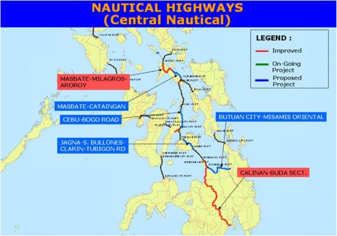
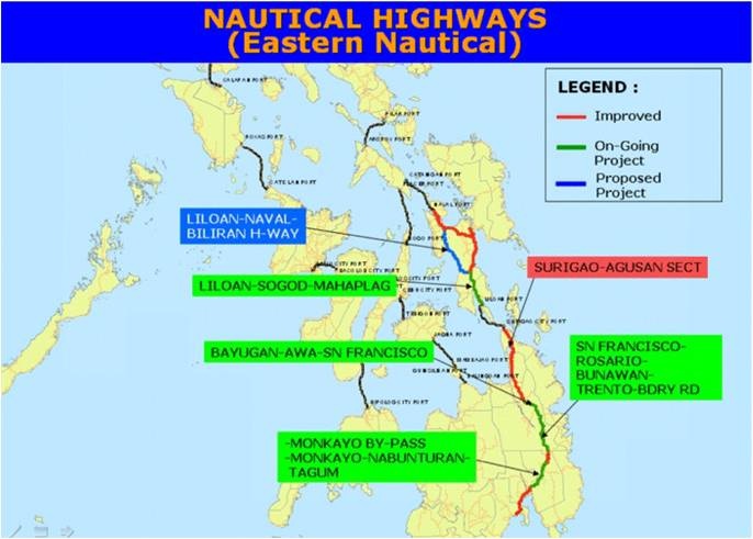
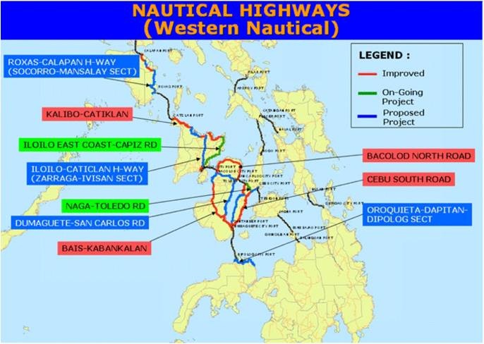
Transport Corridors
The main transport Corridor in the Philippines is an integrated network of highways and vehicle ferries that form the Strong Republic Nautical Highway (SRNH). The 919 kilometres SRNH covers the provinces and cities of Oriental Mindoro, Tagaytay City (Cavite), Marindugue, Romblon, and Batangas City in Luzon; Aklan, Antique, Iloilo, Capiz, Negros Oriental, Negros Occidental, Bohol, Bebu, Guimaras and Siguijor in the Visayas; and Misamis Occidental, Misamis Oriental, Lanao del Norte and Dapitan City in Mindanao.

Road Security
Security Level: Good
Road security in the Philippines is generally good. However there are a few problem areas which transporters will know about. Areas around Apayo (Ilocos) and Maguindanao (Mindanao) have reported unauthorised roadblocks where drivers have been forced to handover money, weapons and any high-end goods. Cargo (including food) is generally unaffected.
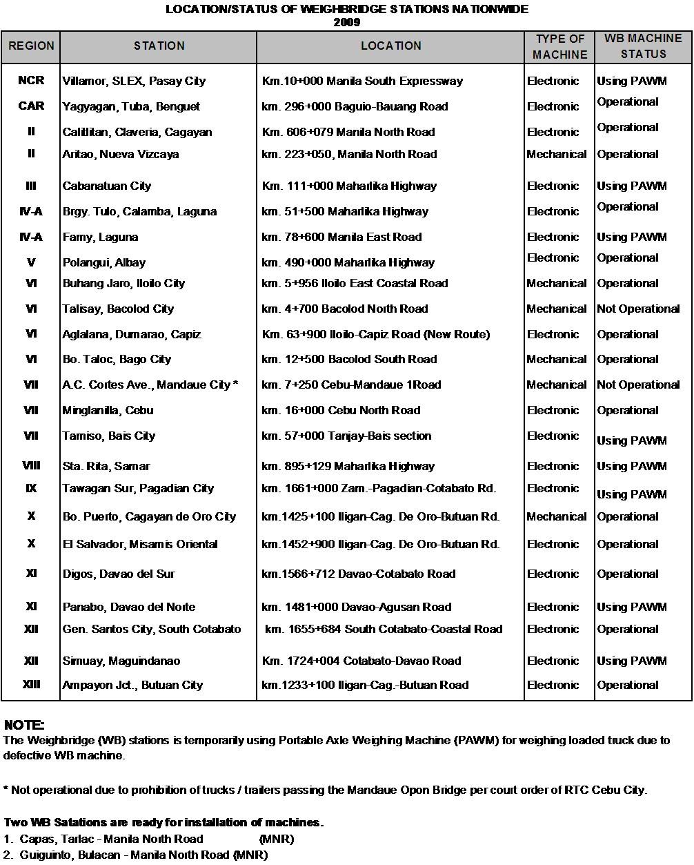
Weighbridges and Axle Load Limits
Weighbridges
Weighbridges are operational 24 hours and are well-signed upon approach. They are under the management of the Department of Public Works and Highways and the exact locations are listed below.
Axle Load Limits
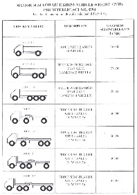
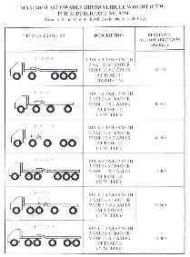
Bridges
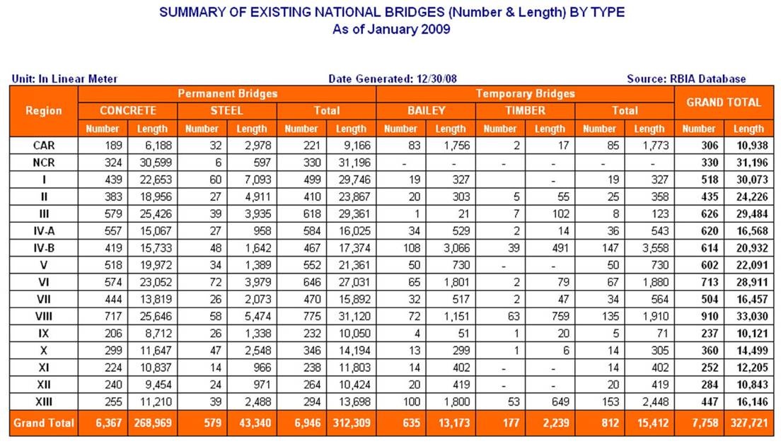
Bridges in the Philippines are prone to collapse during typhoons and landslides. Under regular use most bridges in the Philippines do not pose any particular problems, although drivers should note that sometimes they are inadequately signed and without load limits. In some cases, bridges may have a capacity less than the regular traffic load of the road and as a result, occasionally collapse, however DPWH pointed out this usually only occurs when transporters over-load their vehicles.
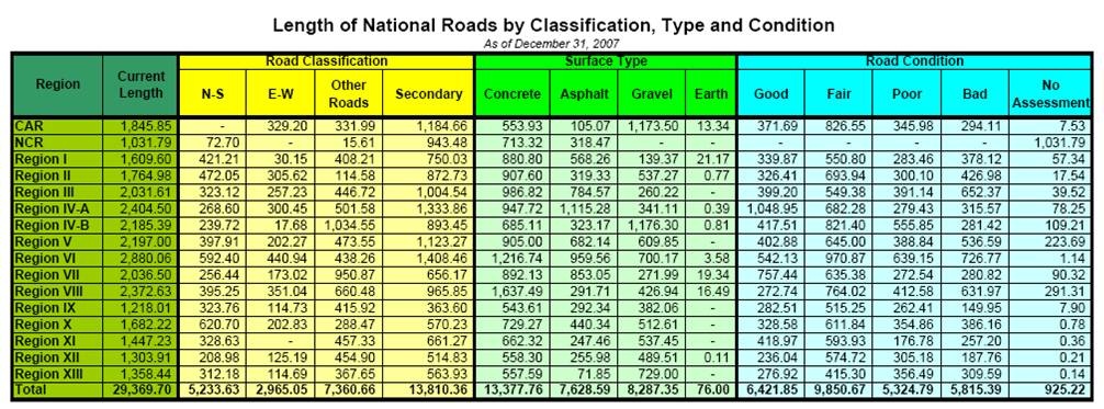
Road Class and Surface Conditions
Road Construction / Maintenance
In general, there are three type of maintenance conducted within the Philippines; periodic, preventative and routine. Further information on ongoing construction and maintenance projects can be found on the Department of Public Works and Highways website: http://www.dpwh.gov.ph/ and through the relevant Bureaus which can be contacted through the main telephone line.
Road Classification
Road classification in the Philippines is completed based on the strategic importance of the road. Road classification does not indicate the surface, quality or width of the road.
| Classification | Description |
|---|---|
|
Primary/National/Arterial (includes the North-South, East-West
and Other Roads classifications in the table below)
|
Main roads in the Philippines that form the backbone of the
road network. Surfaces can be concrete, asphalt, gravel or
earth.
|
|
Secondary
|
Secondary roads do not have as many connecting roads as the
primary roads. Surfaces can be concrete, asphalt, gravel or
earth.
|
|
Local
|
Local road classification includes all other provincial,
municipal, city and barangay roads. Surfaces can be concrete,
asphalt, gravel or earth.
|
Further information on the Road Network of the Philippines can be found on the following webpage: Road and Bridge Information Application (RBIA)
