
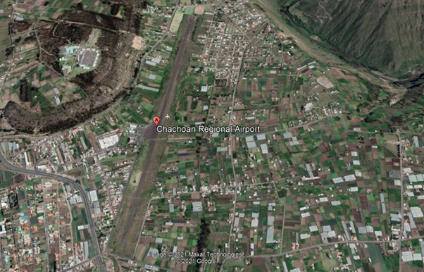
Airport Overview
Chachoán airport is only operational during the day.
|
Airport Location and Contact |
|
|---|---|
|
Country |
Ecuador |
|
Province or District |
Tungurahua |
|
Nearest Town or City |
Ambato (6km) |
|
Airport’s Complete Name |
Aeródromo Nacional “Chachoán” |
|
Latitude |
-1.211944 |
|
Longitude |
-78.57444 |
|
Elevation (ft and m) |
8,391 ft / 2,558 m |
|
IATA Code |
ATF |
|
ICAO Code |
SEAM |
|
Managing Company or Airport Authority |
Ministry of National Defense Directorate of Specialized Technical Consulting (DATE) Ecuadorian Air Force |
|
Management Contact Person |
|
|
NGO and/or UN Presence at Airport? |
NO |
Observations: Prior permission from the Ministry of National Defence is required for civil aircraft operations.
Runway
|
Runway #1 |
|
|---|---|
|
Runway Dimensions |
1,925 m x 25 m Runway Side Strip 2042 x 150 m |
|
Runway Orientation |
01/19 |
|
Runway Surface |
SIWL 13636 DW 17273 Pavement, asphalt |
|
Runway Condition |
N/A |
Airport Infrastructure Details
|
Infrastructure |
|||
|---|---|---|---|
|
Passenger / Cargo Security Screening |
No |
Runway Lighting |
No |
|
Refueling Capacity |
No |
Ground Handling Services |
No |
|
Air Traffic Control |
N/A |
Fire Fighting Equipment |
N/A |
|
Weather Information |
Yes 1 |
Aircraft Parking Space |
No |
|
Navigation Aids |
No 2 |
Perimeter Fencing |
No |
|
Windsock |
Yes |
|
|
- Meteo Ambato: INFORMACION_METEOROLOGICA_PROPORCIONADA Ambato
- Nav Aid , NO. Source RADIOAYUDAS_PARA_LA_NAVEGACI.C3.93N_Y_EL_ATERRIZAJE Ambato
Helipad
Si , _AREA_DE_ATERRIZAJE_PARA_HELICOPTEROS Ambato
Fuel Services Charges
N/A
|
Price per Litre USD - $ |
|
|---|---|
|
Jet A-1 |
N/A |
|
Avgas |
N/A |
Royalties / Non Objection Fees (NOFs)
N/A
