
Indonesia Nusa Tenggara Barat (NTB) Waterways Assessment
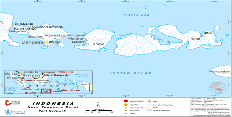
The use of the waterways between islands is a key mode of transport for cargo and passengers within the NTB province.
Ports are located throughout the islands and there are ferry options to move within the islands or to Bali.
In case of an emergency operation PT. ASDP would offer ferries available for rental.
The port of Surabaya is a major hub for the NTB with regular sailings of boats and ferries with passengers and cargo.
Company Information
For information on Indonesia waterways contact details, please see the following link:
4.2.4 Indonesia Port and Waterways Company Contact Lists
Two companies operate scheduled passenger and cargo ferry services on a large scale within NTB - PT.Pelni and PT ASDP.
In addition to the larger services there are a number of tourism operators who provide “speed” boat services between NTB and Bali.
|
Passenger Carrying Capacity |
|||
|---|---|---|---|
|
PT. PELNI |
PT. ASDP Ferry |
Fast Boat Blue Water Express |
|
|
Number of Passenger Vessels < 20 pax |
N/A |
N/A |
N/A |
|
Number of Passenger Vessels < 50 pax |
N/A |
N/A |
2 |
|
Number of Passenger Vessels < 100 pax |
N/A |
N/A |
1 |
|
Number of Passenger Vessels > 100 pax |
6 |
8 |
N/A |
|
Passenger Carrying Capacity |
|||
|---|---|---|---|
|
PT. PELNI (Persero) |
PT. ASDP Ferry Indonesia |
Fast Boat Blue Water Express |
|
|
Number of Boats |
6 |
8 |
3 |
|
Tonnage / Volume Carrying Capacity |
45mt |
45 mt per trip |
N/A |
|
Number of Barges |
N/A |
N/A |
N/A |
|
Tonnage / Volume Carrying Capacity |
N/A |
N/A |
N/A |
|
Number of Tugs |
N/A |
N/A |
N/A |
|
Tonnage / Volume Carrying Capacity |
N/A |
N/A |
N/A |
|
Other (specify) |
N/A |
N/A |
N/A |
Travel Time Matrix
|
|
Travel Time from Main port to other major Ports (hours / days) by Passenger ferry (PELNI) and Ferry (ASDP) |
|||||
|---|---|---|---|---|---|---|
|
Lembar |
Kayangan |
Bima |
Pototano |
Padang Bai |
Labuhan Bajo |
|
|
Lembar |
N/A |
PELNI: 17-18 hours |
N/A |
ASDP: 3-6 hours |
PELNI: 1 days |
|
|
Kayangan |
N/A |
N/A |
ASDP: 1,5 hours |
N/A |
N/A |
|
|
Bima |
PELNI: 17 hours |
N/A |
N/A |
N/A |
PELNI: 1,5 days |
|
|
Pototano |
N/A |
ASDP: 1,5 hours |
N/A |
|
N/A |
N/A |
|
Padang Bai |
ASDP: 3-6 hours |
N/A |
N/A |
N/A |
N/A |
|
|
Labuhan Bajo |
PELNI: 1 days |
N/A |
PELNI: 1,5 days |
N/A |
N/A |
|
Key Routes
|
Key Route Information Domestic / International |
|||
|---|---|---|---|
|
From: Lombok To: Bali |
From: Lombok To: Sumbawa Island |
From: Sumbawa Island To: East Nusa Tenggara (NTT) |
|
|
Total Distance (km) |
70.899 km |
19.312 km |
77.249 km |
|
Width (m): Broadest Narrowest |
Ocean Width |
Ocean Width |
Ocean Width |
|
River Flow (m³ / second) |
N/A |
N/A |
N/A |
|
Seasonal Affects |
Rainy season and Winded |
Rainy season and Winded |
Rainy season and Winded |
|
Maximum Weight and Size of Vessels |
N/A |
N/A |
N/A |
|
Regular Traffic Passenger / Cargo |
Passenger & Cargo |
Passenger & Cargo |
Passenger & Cargo |
|
Companies Operating Along the Route |
PELNI & ASDP |
ASDP |
ASDP |
|
Security Concerns (Yes / No) |
No |
No |
No |
|
Main Ports |
Lembar – Padang Bai |
Kayangan – Poto Tano |
Sape – Labuhan Bajo |
Port Information
|
Tanjung Lembar |
Kayangan |
|
|---|---|---|
|
Location |
S. 0900, 43’, 50” E. 11600 4’, 20” |
S. 080, 29’, 07,7”, E. 1160, 40’, 28,7” |
|
Contact Information |
PT. Pelabuhan Indonesia III (Persero) |
Kayangan Port Office (Kantor Pelabuhan Kayangan) |
|
Connections with other transport means (road/waterways/air) |
PT. PELNI and PT. ASDP Ferry |
PT. PELNI and PT. ASDP Ferry |
|
Storage Capacity (square meters and cubic meters) |
1.008 - 2.016 mt/m3 and open storage 8.925 mt/m3 |
1.500 metric tons |
|
Handling Equipment |
Yes |
No |
|
Customs Clearance Available (Yes / No) |
Yes |
No |
