Honduras - 2.3 Road Network
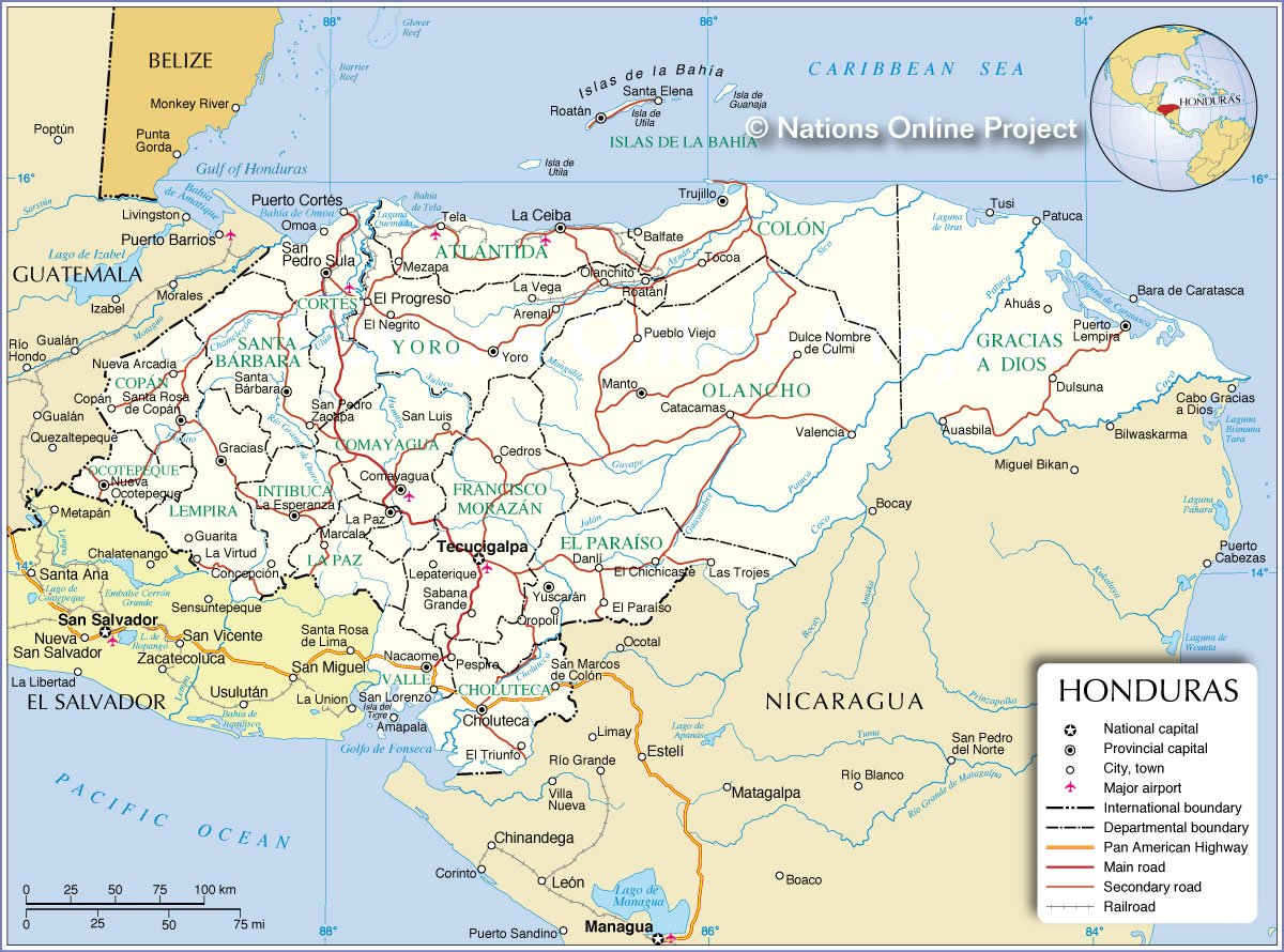
The official roads of the country have an extension of 14,346 kilometers, according to information from the Honduran Road Fund. These roads are classified into four aggregates: primary road network; secondary road network; neighbourhood road network; Tertiary road network. Within the primary road network are the main roads linking cities or are of national importance, regardless of whether they are paved or not. The secondary road network is made up of the roads that connect towns and cities to the primary road network and have relevance at the departmental level. The neighborhood road network is made up of roads that connect secondary and primary road networks with towns and / or villages and have importance within the municipalities, The tertiary road network is made up of some trails built by private institutions and are not interference of the Honduran Road Fund.
Distance matrix
|
Distances from the capital to major cities (km) |
||||||||
|---|---|---|---|---|---|---|---|---|
|
Tegucigalpa |
San Pedro Sula |
Ceiba |
Puerto Cortes |
Screen |
Comayagua |
Choluteca |
Santa Rosa de Copan |
|
|
Tegucigalpa |
252 |
395 |
307 |
304 |
91.7 |
141 |
311 |
|
|
San Pedro Sula |
251 |
190 |
27.6 |
92.4 |
161 |
358 |
156 |
|
|
Ceiba |
402 |
191 |
165 |
101 |
312 |
508 |
337 |
|
|
Puerto Cortes |
306 |
54.1 |
242 |
144 |
216 |
412 |
211 |
|
|
Screen |
304 |
92.6 |
101 |
67,2 |
214 |
410 |
239 |
|
|
Comayagua |
91,1 |
162 |
312 |
148 |
214 |
198 |
298 |
|
|
Choluteca |
141 |
358 |
508 |
344 |
410 |
198 |
396 |
|
|
Santa Rosa de Copan |
311 |
157 |
338 |
175 |
240 |
215 |
398 |
|
Time Matrix
|
Travel time from the capital to major cities |
||||||||
|---|---|---|---|---|---|---|---|---|
|
Tegucigalpa |
San Pedro Sula |
Ceiba |
Puerto Cortes |
Screen |
Comayagua |
Choluteca |
Santa Rosa de Copan |
|
|
Tegucigalpa |
3 hr 54 min |
8 hr 12 min |
3 hr 41 min |
5 hr 10 min |
1h 26 min |
2 hr 46 min |
5 hr 40 min |
|
|
San Pedro Sula |
3 hr 46 min |
3 hr 39 min |
58 min |
1 hr 53 min |
2 hr 37 min |
5 hr 25 min |
3 hr 10 min |
|
|
Ceiba |
6 hr 40 min |
3 hr 52 min |
4 hr 47 min |
2 hr 6 min |
5 hr 38 min |
8 hr 21 min |
6 hr 25 min |
|
|
Puerto Cortes |
4h 54 min |
57 min |
4 hr 41 min |
2 hr 53 min |
3 hr 47 min |
6 hr 18 min |
4 hr 19 min |
|
|
Tela |
4 hr 59 min |
1 hr 57 min |
2 hrs |
2 hr 49 min |
3 hr 54 min |
6 hr 31 min |
4 hr 43 min |
|
|
Comayagua |
1 hr 26 min |
2 hr 39 min |
5 hr 40 min |
3 hr 44 min |
3 hr 56 min |
3 hr 5 min |
4 hr 44 min |
|
|
Choluteca |
2 hr 39 min |
5 hr 29 min |
8 hr 21 min |
6 hr 26 min |
6 hr 34 min |
2 hr 56 min |
6 hr 57 min |
|
|
Santa Rosa de Copan |
5 hr 45 min |
3 hr 22 min |
6 hr 49 min |
4 hr 27 min |
5 hr 3 min |
4 hr 48 min |
7 hr 16 min |
|
Security
In the Republic of Honduras, the Honduran Traffic Accident Information System is under the responsibility or competence of the National Traffic Directorate of Honduras.
It can be deduced that in Honduras the issue of road safety arose in 2005 (first actions), with the Program for Sustainable Institutional Strengthening of the Road Sector, with the study carried out by the firm THE LOUIS BERGER GROUP INC., in which policies are established, under the tutelage of the National Road Safety Council (CONASEVI).
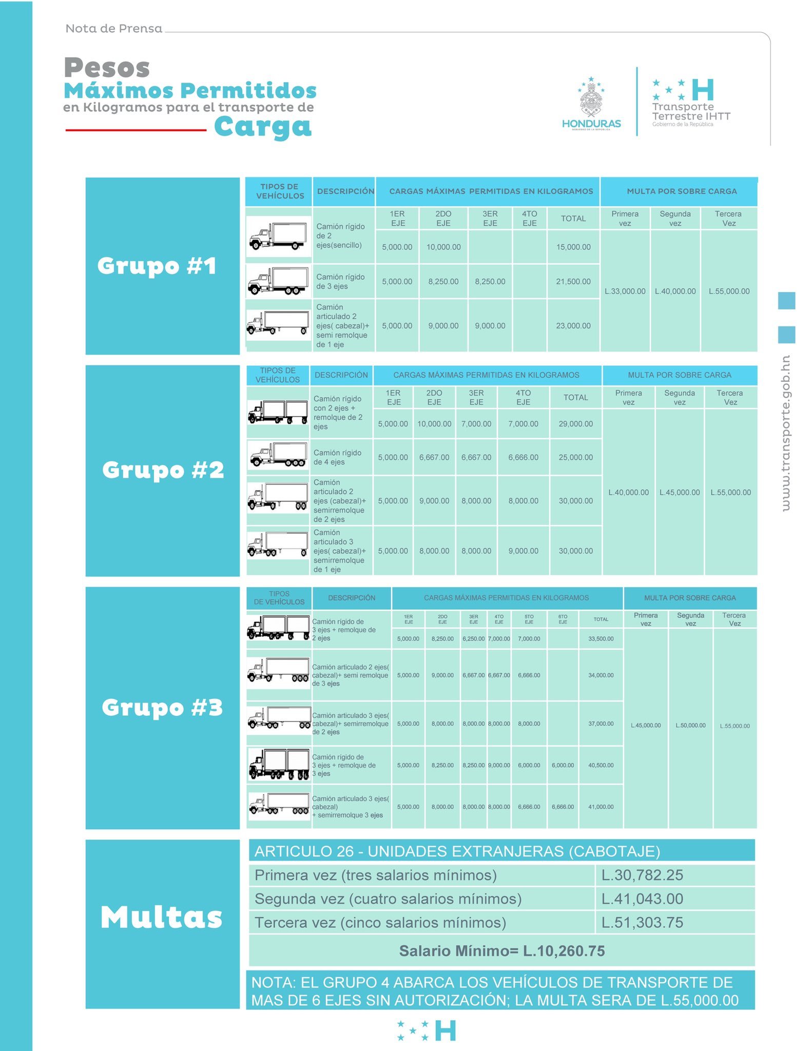
Bridge scales and axle load limits