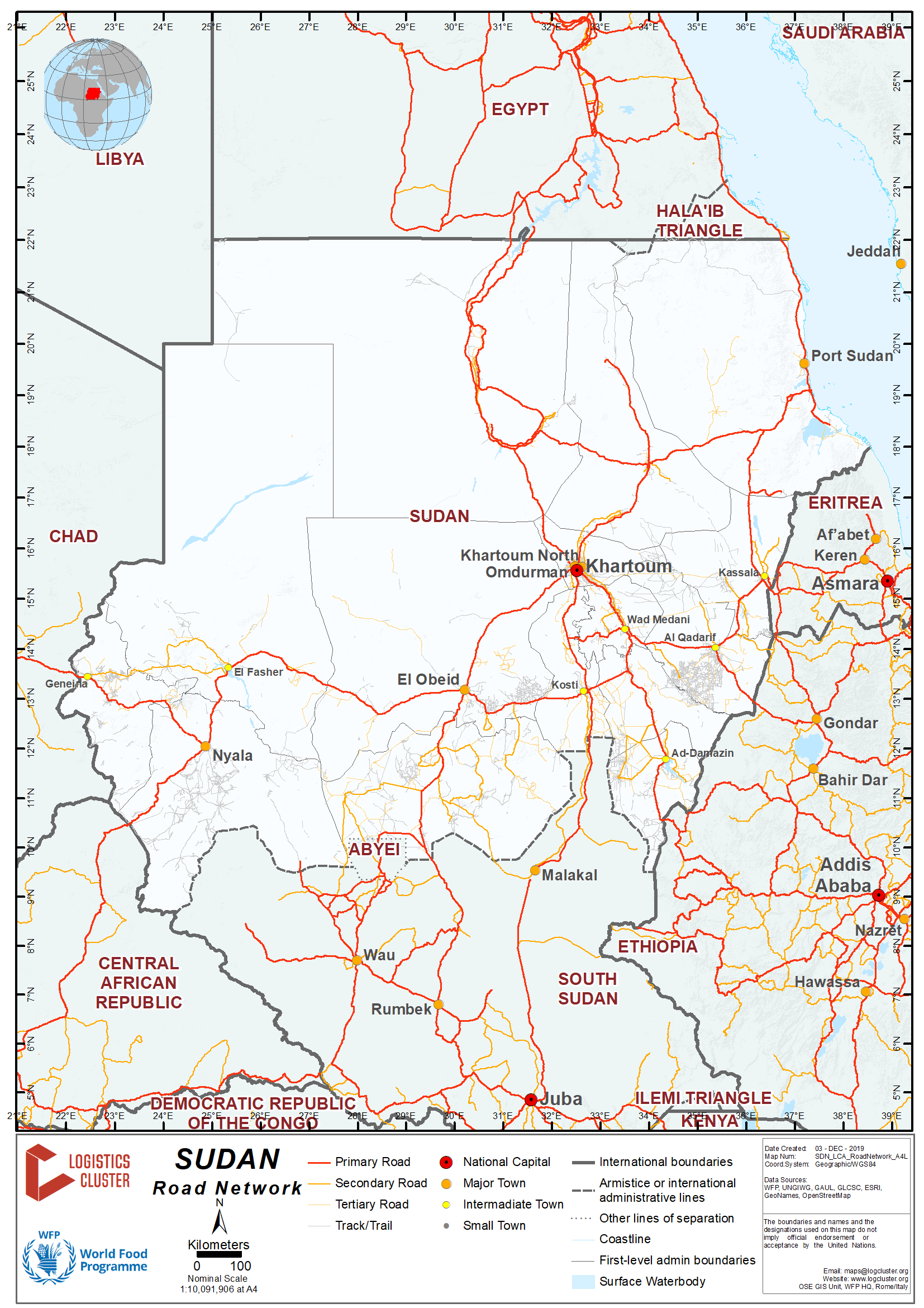
2.3 Sudan Road Network
For more information on contact details, please see the following link: 4.1 Sudan Government Contact List
The Republic of Sudan’s road network covers approximately 30,000 km of road, of which 7,000 km are asphalted, 4300 km are gravelled. In addition to urban roads and urban programmes total an additional 1,000 km of paved road.
Distance Matrix
|
Distances from Capital City to Major Towns (km) |
||||||||
|
Khartoum |
Capital |
El Obeid |
Kosti |
Port Sudan |
Nyala |
El Fasher |
El Geneina |
Kadugli |
|
Khartoum |
|
620 |
300 |
1120 |
1356 |
1270 |
1706 |
920 |
|
El Obeid |
620 |
|
620 |
1740 |
730 |
642 |
1078 |
278 |
|
Kosti |
300 |
300 |
|
1440 |
680 |
880 |
1700 |
320 |
|
Port Sudan |
1120 |
1740 |
1420 |
|
2420 |
2420 |
2770 |
2040 |
|
Nyala |
1356 |
730 |
1000 |
2420 |
|
190 |
370 |
980 |
|
El Fasher |
1270 |
642 |
880 |
2420 |
190 |
|
360 |
880 |
|
El Geneina |
1706 |
1078 |
1700 |
2770 |
370 |
360 |
|
1330 |
|
Kadugli |
920 |
278 |
620 |
2040 |
980 |
880 |
1330 |
|
Travel time has been calculated on the average speed of 50 km per hour (considering status of roads) plus 25% to cover rest periods and usual breaks in the route.
The worst case scenarios will need to factor in prolonged delays due to road conditions, the rainy season (May to October), delays of convoys and escorts, and potential mechanical failures.
|
Travel Time from Capital City to Major Towns (Hours / Days) |
||||||||
|
|
Capital |
El Obeid |
Kosti |
Port Sudan |
Nyala |
El Fasher |
El Geneina |
Kadugli |
|
Khartoum |
|
8 Hours |
4 Hours |
3 Days |
4 Days |
2 days |
4 Days |
1 day |
|
El Obeid |
1 day |
|
4 Hours |
4 days |
3 days |
1 day |
3 days |
3 Hours |
|
Kosti |
1 Day |
4 Hours |
|
3 days |
4 days |
2 days |
4 days |
6 Hours |
|
Port Sudan |
3 Days |
4 days |
3 days |
|
7 days |
5 days |
7 days |
5 days |
|
Nyala |
3 Days |
3 days |
4 days |
7days |
|
2 days |
2 days |
4 days |
|
El Fasher |
3 Days |
One day |
2 days |
5 days |
2 days |
|
2 days |
2 days |
|
El Geneina |
4 Days |
3 days |
4 days |
7 days |
2 days |
2 days |
|
4 days |
|
Kadugli |
1 Day |
3 Hours |
6 Hours |
5 days |
4 days |
2 days |
4 days |
|
Road Security
The security requirements and scenarios vary depending on the routes. All road transportation requires security clearance from HAC, NISS and MCS, with for UN agencies oversight from UNDSS and from the Security units of each UN Agency. On specific routes, road haulers are required to move under convoy with security from UNAMID and/or Sudanese Police or Army. Convoys and the related escorts must be arranged well in advance with UNAMID and/or the relevant authority. All clearances must be arranged through HAC, NISS and MCS.
In addition the prevailing seasonal weather conditions must also be taken into consideration, wash ways, flooded rivers that cause roads to be impassable, the presence of animals on the road (camels, livestock) and the bad conditions of several roads (potholes etc.). The distances are vast, there is negligible roadside support in case of accidents or breakdowns, and thus it is important to adhere to security procedures and standards.
Weighbridges and Axle Load Limits
The National Highway Authority ensures that road vehicles are laden based on axle distribution. Weighbridges are positioned in strategic locations to enforce safety and legislation on ‘safe working loads/limits’.
The Sudanese Chamber of Transport Union advises that the maximum axle load limitations for road trucks on Sudan roads are:
|
Axle load limits |
Sudan |
Chad |
|
Truck with 2 axles |
16 Metric tons |
21 Metric Tons |
|
Truck with 3 axles |
24 Metric Tons |
27 Metric tons |
|
Truck with 4 axles |
32 Metric Tons |
|
|
Semi-trailer with 3 axles |
- |
- |
|
Semi-trailer with 4 axles |
- |
- |
|
Semi-trailer with 5 axles |
- |
- |
|
Semi-trailer with 6 axles |
- |
- |
|
Truck and drawbar trailer with 4 axles |
- |
- |
|
Truck and drawbar trailer with 5 axles |
- |
- |
|
Truck and drawbar trailer with 6 axles |
- |
- |
|
Truck and drawbar trailer with 7 axles |
- |
- |
New regulation in 2017 stipulated that the maximum load limit is 54 mt.
Loading dimensions should not exceed 3 metres in height and 2.5 metres in width; any loading exceeding these parameters may be considered as “abnormal loading” and may require escorts to caution other road users on dangerous ‘out of gauge‘ traffic.
CHAD: The axle weight maximum for one axle is 13 Metric Tons. The configuration of the loads should not exceed 2.5 metres (width) and 4 metres (height).
SUDAN: The axle weight maximum for one axle is 10 Metric Tons.
Road Corridor Assessments
The following table shows WFP corridors inside Sudan for both WFP fleet and commercial transporters convoys:
|
Origin |
Destinations |
|
Port Sudan |
Khartoum, El Obeid, Kassala, Ed Damazine |
|
Khartoum |
El Fasher, Nyala, Geneina, Ed Daein, El Obeid |
|
El Obeid |
El Fasher, Ed Daien, Nyala, Mukjar, Geneina, Kadugli |
|
Nyala |
El Fasher, Geneina |
|
Geneina |
Ed Daein |
From El Obeid to El Fasher
El Obeid is the main intermediate hub for food aid going to Western Sudan (Darfur); it represents one of the primary hubs in Sudan for both commercial and WFP operations, due to its central geographical location, that links the port in the East to the Western and Southern areas of the country. Therefore, most of transport companies in Sudan have a representative/branch office in El Obeid to facilitate their transport business to West and South Sudan.
The main road from El Obeid to El Fasher is a paved/asphalt highway and is accessible throughout the year to all types of traffic. This road is safe and there is no need for escorts for both WFP fleet and commercial trucks. The journey route is El Obeid – En Nuhud – Dam Jamad – Um Kadada – Al Koma – El Fasher. Starting point of the escort is in Darfur (El Fasher) – Zalingei – Morni – El Geneina.
General information:
|
Total distance (km or miles) |
642 Km |
|
Total travel time |
One day |
|
Road classification |
Asphalt |
|
Security (Good, marginal, bad) |
Marginal |
|
Main towns/hubs |
El Nuhud |
From El Obeid to Nyala:
The main road from El Obeid to Nyala is paved/asphalt up to El Nuhud town (206 Km) while the rest (474 Km) is dirt. The dirt part of the road is usually blocked during rainy season in some parts. The journey route is El Obeid – Babanosa – Ed Daein – Nyala (starting point of the escort as the next point will be in Darfur) – Zalingei – Morni – El Geneina. Some routes can be accessed during the dry season only, while there are alternative roads that are used during the rainy season. The rainy season affects transport rates as transporters have to depend on longer routes so as to reach the inaccessible destinations, resulting in an increase of transportation rates by nearly 20% to 25% compared to the dry season rates.
General information:
|
Total distance (km or miles) |
730 Km |
|
Total travel time |
3 days |
|
Road classification |
Asphalt (2016 Km) + dirt (474 Km) |
|
Security (Good, marginal, bad) |
Marginal |
|
Main towns/hubs |
El Nuhud |
From El Obeid to Kadugli
The main road from El Obeid to Kadugli is tarmac and accessible to all traffic. However, El Obeid to Abu Jebeeha, Kalogi and Talodi is only useable in the dry season.
General information
|
Total distance (km or miles) |
287 Km |
|
Total travel time |
3 Hours |
|
Road classification |
Tarmac |
|
Security (Good, marginal, bad) |
Marginal |
|
Main towns/hubs |
El Dalanj |
From El Fasher to El Geneina
The main road from El Fasher to El Geneina is gravel, and is accessible only during the dry season. It is suitable only for heavy trucks (15 – 23 MTs) without trailer as well as light vehicles pick-up (4WD).
General information:
|
Total distance (km or miles) |
360 Km |
|
Total travel time |
2 days |
|
Road classification |
Dirt |
|
Security (Good, marginal, bad) |
Bad |
|
Main towns/hubs |
Kutum, Saraf Omra |
Escorting
Escorting trucks is very important to ensure the safe delivery of commodities and cargo. Insecurity can impact dispatches to conflict areas resulting in delays in delivery, high transport rates, and high level of losses.
Government of Sudan police usually organises and conducts military escort to protect fuel tankers passing through Darfur states. Also trucks that carry dry cargo are included in this type of escorting which can involve up to 500 vehicles.
Escorts movement usually takes place three times per month (the gap between each escort and next one is 10 days), but sometimes movements are affected by the readiness and actual security situation in the respective area. The allowed average speed for the escorted trucks is 50 to 70 Km/hour during the daylight and no trucks movement is allowed during night hours.
Obstacles and bridges
|
Mines/UXO |
Under review and reporting by UNMAS, UNAMID and UNISFA. |
|
Road block |
Gateways to major cities, Town and main road junctions |
|
Check point – official |
Gateways to major cities, Town and main road junctions |
|
Check point – unofficial |
There are ‘unofficial road ‘blocks ‘set and removed without notice. |
|
Debris/wreckage |
There is no permanent debris – wreckage that inhibit movements |
|
Downed electrical lines |
Nil – Lines in the rural areas are generally away from Roads. |
|
Avalanche/snow |
No |
|
Landslide/Mudslide |
Occur during the rains (May – October) |
|
Ice |
No |
|
Flooded |
From May to October, wadis flood may lead to impossible movement on secondary, tertiary roads for periods of time. |
|
Wet crossing |
Causeways and culverts may be submerged during the rains, Rivers and Wadis may encroach over the low bridges, culverts and roads. |
|
Road damage |
Sections of roads may be eroded during the rains, on the main arterial roads, potholes are evident, on gradients and intersection, and the roads tend to ‘corrugate’ due to the traction of heavily laden commercial carriers. |
|
Bridge |
Commercial vehicles have restricted timeframes to cross the bridges into Khartoum in order to reduce the traffic congestion. |
|
Culvert |
|
|
Traffic restriction |
Commercial vehicles have restricted timeframes to cross the bridges into Khartoum in order to reduce the traffic congestion. |
|
Other – please specify |
All road movements are subject to security clearance from internal UN procedures and HAC, NISS and MCI. |