Democratic Republic of Congo - 2.2.8 Democratic Republic of Congo Bunia National Airport(Category 2)
Most of the National airports and airfields do not possess the adequate infrastructure nor offer the services demanded by the airline industry.
|
Airport Details |
|||
|---|---|---|---|
|
Country |
DRC |
Latitude |
1.565719 |
|
Province / District |
PROVINCE ORIENTALE |
Longitude |
30.22083 |
|
Airport Name |
BUNIA Airport |
Elevation (ft) |
4,045 ft / 1,232.92 m |
|
IATA & ICAO codes |
BUX / FZKA |
Surface |
Asphalt |
|
Town or City (closest) |
BUNIA |
Runway Condition |
Good |
|
Humanitarian air agencies using regularly this facility |
UNHAS ECHOFLIGHT MAF |
Passenger / Cargo Security Screening (Yes / No) |
No |
|
Runway Dimension |
1,850 m x 30 m |
Ground Handling (Yes / No) |
Yes |
|
Refueling Capacity |
Yes |
Runway Lighting (Yes / No) |
No |
|
Runway Heading |
Yes |
Fire Fighting Equipment (Yes / No) |
Yes |
|
Air Traffic Control (Yes / No) |
Yes |
Windsock (Yes / No) |
Yes |
|
Weather Information (Yes / No) |
Yes |
Aircraft Parking space (Yes / No) |
Yes |
|
Navigation Aids (Yes / No) |
Yes |
Perimeter fencing (Yes / No) |
Yes |
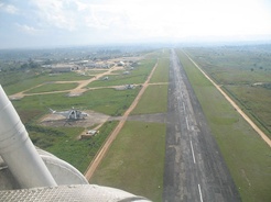
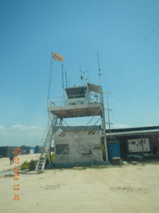
Overview and control tower.