2.5 Cook Islands Waterways
There are no ‘internal’ waterways in the Cook Islands however as a nation that is formed by an ‘Island Group’ interisland water transport along with air travel are the only forms of transportation for people and the main form of transport for goods within in the country.
Ferries and landing craft are used extensively for transportation of people and cargo. Many of the outer Islands do not have docking facilities for large ships and therefore transhipment using small boats and barges from ships anchored off, to beach or wharf is the norm. Landing craft are the preferred option for heavy cargo / vehicle transportation.
Private shipping companies operate non-scheduled inter-island cargo and passenger services, based on demand. Generally they visit the Northern Islands on a 2 monthly basis and the closer Southern Group weekly.
For more information on government contact details, please see the following link: 4.1 Government Contact List
Company Information
There are 2 companies operating freight shipping services from the Port in Rarotonga, one of which, Taio Shipping Company, has duel purpose vessels fitted for passenger service as well. Due to the large distances and smaller cargo volumes to the outer islands services are cargo dependent on sailing frequency. The other, Cook Islands General Transport’s sea freight division, UMA shipping, operates a barge (landing craft) fitted with 5MT crane. They also have a 12m landing craft that is used to access shallow (5m draft) outer island harbours. A 40 MT mobile crane is used to launch the smaller landing craft from the barge and then load heavy cargo from barge to landing craft for transport to shore.
For more information on waterway company contact details, please see the following link: 4.4 Port and Waterways Companies Contact List
|
Passenger Carrying Capacity |
||
|---|---|---|
|
Taio Shipping Company |
Cook Islands General Transport (UMA Shipping) |
|
|
Number of Passenger Vessels < 20 Passengers |
N/a |
N/a |
|
Number of Passenger Vessels < 50 Passengers |
1 x 30 pax (M.V Lady Moana) |
N/a |
|
Number of Passenger Vessels < 100 Passengers |
1 x 50 pax M.V Maungaroa |
N/a |
|
Number of Passenger Vessels > 100 Passengers |
N/a |
N/a |
|
Cargo Carrying Capacity |
||
|---|---|---|
|
Taio Shipping Company |
Cook Islands General Transport |
|
|
Boats |
||
|
Number of Boats |
2 |
N/a |
|
Tonnage / Volume Carrying Capacity (MT / m3) |
M.V Lady Moana 180MT M.V Maungaroa 180MT |
N/a |
|
Barges / Landing Craft |
||
|
Number of Barges/Landing Craft |
N/a |
2 x Landing Craft |
|
Tonnage / Volume Carrying Capacity (MT / m3) |
N/a |
1 x 400MT 468m3 (12 x 20” containers) 1 x 12MT 39m3 (1 x 20’ container) |
|
Tugs |
||
|
Number of Tugs |
N/a |
N/a |
|
Tonnage / Volume Carrying Capacity (MT / m3) |
N/a |
N/a |
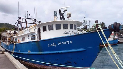
M.V Lady Moana
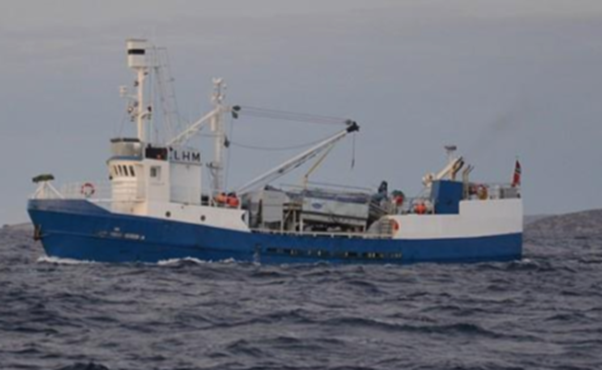
M.V Maungaroa
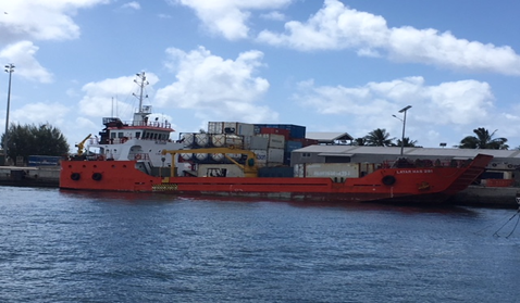
Cook Islands General Transport Barge (Landing Craft)
Travel Time Matrix
|
Travel Time from Main port to other Ports/Islands on Domestic Cargo Vessel, Fishing Vessels. Average of 7 knots. |
||
|---|---|---|
|
To |
FROM PORT AVATIU, RAROTONGA |
|
|
Distance: Note: All measurements are taken in nautical miles (nm) to the nearest point of land.
|
Sailing time: Note: Sailing time is worked on distance/average speed and pending on the weather. E.g. Aitutaki - 140nm/7knots = 20hours of sailing time to Aitutaki. |
|
|
Aitutaki |
140nm |
20 hours. |
|
Atiu |
116nm |
19.3 hours |
|
Manuae |
124nm |
17.7 hours
|
|
Mauke |
150nm |
21.4 hours |
|
Mangaiia |
110nm |
15.7 hours |
|
Mitiaro |
142nm |
20.2 hours |
|
Takutea |
116nm |
19.3 hours |
|
Manihiki |
650nm |
92.85 hours/3.8 days |
|
Nassau |
673nm |
96.14 hours/4.0 days |
|
Palmerston |
270nm |
38.5 hours/1.6 days |
|
Penrhyn |
737nm |
105.3 hours/4.4 days |
|
Pukapuka |
715nm |
102.14 hours/4.2 days |
|
Rakahanga |
674nm |
96.28 hours/4.0 days |
|
Suwarrow |
513nm |
73.28 hours/3.05 days |
As there are no ‘internal’ waterways in the Cook Islands, the remainder of this section is not applicable.