Brazil - Limited Port Assessment
|
Country Name |
Brazil |
|---|---|
|
Official Country Name |
Federal Republic of Brazil |
|
Assessment Details |
|
|
From |
11 DEC 18 & 13 JAN 19 |
|
To |
15 DEC 18 & 19 JAN 19 |
|
Name of Assessor |
Nafi Mert Kazmirci |
|
Title and Position |
WFP Shipping Consultant |
|
Contact |
|
Table of Contents
| Chapter | Assessor | Organization | Date of Assessment |
|---|---|---|---|
| 1 Brazil Country Profile | Nafi Mert Kazmirci | WFP | January 2019 |
| 2 Brazil Logistics Infrastructure | Nafi Mert Kazmirci | WFP | January 2019 |
| 2.1 Brazil Port Assessment | Nafi Mert Kazmirci | WFP | January 2019 |
| 2.1.1 Brazil Port of Santos | Nafi Mert Kazmirci | WFP | January 2019 |
| 2.1.2 Brazil Port of Itacoatiara | Nafi Mert Kazmirci | WFP | January 2019 |
| 2.1.3 Brazil Port of Santarem | Nafi Mert Kazmirci | WFP | January 2019 |
| 2.1.4 Brazil Port of Barcarena (Vila Do Conde) | Nafi Mert Kazmirci | WFP | January 2019 |
| 2.1.5 Brazil Port of Itaqui | Nafi Mert Kazmirci | WFP | January 2019 |
| 3 Brazil Contact List | Nafi Mert Kazmirci | WFP | January 2019 |
1 Brazil Country Profile
Generic Information
Brazil, officially the Federal Republic of Brazil, is the largest country in both South America and Latin America. At 8.5 million square kilometres (3.2 million square miles) and with over 208 million people, Brazil is the world's fifth-largest country by area and the fifth most populous. The capital is Brasília, and the most populated city is São Paulo. The federation is composed of the union of the 26 states, the Federal District, and the 5,570 municipalities. It is the largest country to have Portuguese as an official language and the only one in the Americas; it is also one of the most multicultural and ethnically diverse nations, due to over a century of mass immigration from around the world.
Bounded by the Atlantic Ocean on the east, Brazil has a coastline of 7,491 kilometers (4,655 mi). It borders all other South American countries except Ecuador and Chile and covers 47.3% of the continent's land area. Its Amazon River basin includes a vast tropical forest, home to diverse wildlife, a variety of ecological systems, and extensive natural resources spanning numerous protected habitats. This unique environmental heritage makes Brazil one of 17 megadiverse countries and is the subject of significant global interest and debate regarding deforestation and environmental protection.
Generic country information can be located from sources which are regularly maintained and reflect current facts and figures. For a generic country overview, please consult the following sources:
Brazil Wikipedia Country Information
Brazil IMF Country Information
Brazil Economist Intelligence Unit Information*
(*note - this is a paid service)
Facts and Figures
2 Brazil Logistics Infrastructure
The following sections are port assessments to Brazil ports.
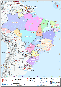
2.1 Brazil Port Assessment
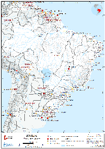
Map of Brazil ports (above). Below map shows main grain routes and flows for Brazilian grain exports.
Source: https://www.amaggi.com.br/en/business/logistics-and-operations/grain-flow-routes/
2.1.1 Brazil Port of Santos
Port Overview
The Port of Santos rests on the alluvial plain of Sao Vicente Island in the State of Sao Paulo in Brazil. Just a few feet above sea level, a tidal channel cuts the island off from the mainland, and concrete channels drain the swampy island to keep the Port of Santos dry. The city lies on both the island and the mainland. The city lies on the shores of a bay with a navigation channel dredged to 14.5 meters, max LOA for the channel is 220 meters. It has been discussed to increase the max LOA to 320 meters and increase the draft to 17 meters but due to environmental concerns, it has not been approved by the government.
Due to lack of space on Sao Vicente island which is the right-bank of Santos Estuary, new terminal investments are located on Santo Amaro Island on the left-bank of Santos Estuary where Guaruja City is located as well. DP World Santos is the exception, which is on Barnabe Island just next to Santo Amaro Island where Sandi and Diana Rivers meet and where further railway connection to Santo Amaro island also passes from.
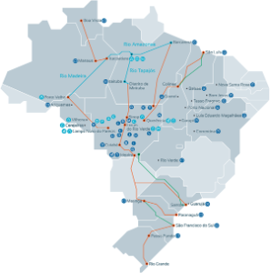
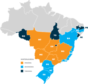
Major cargo types handled by the Port of Santos include coffee, sugar, cotton, oranges, wheat, corn, soy, citrus juices and pulp, alcohol, paper, fertilizer, coal, and vehicles. The Port of Santos is Brazil's largest port, and is the largest port in South America. Today, the Port of Santos handles well over 120 million tons of cargo per year. Almost all of Sao Paulo's industrial base is located less than 200 kilometers (124.3 miles) from the Port of Santos. The Port of Santos' primary area of influence includes the States of Sao Paulo, Goias, Minas Gerais, Mato Grosso, and Mato Grosso do Sul. Its secondary hinterlands include the States of Bahia, Espirito Santo, Tocantins, Parana, Rio de Janeiro, Rio Grande do Sul, and Santa Catarina. Please see below map.
Currently, there are 11 Grain & 5 Container Terminal Operators and they are mostly concessions.
Port website: http://www.portodesantos.com.br/
Key port information may also be found at: http://www.maritime-database.com
Please see the following link for Navigation Guidance: Navigational Notes Port of Santos
|
Port Location and Contact |
|
|---|---|
|
Country |
Brazil |
|
Province or District |
Sao Paulo |
|
Nearest Town or City with Distance from Port |
Santos 0 (km) |
|
Port's Complete Name |
Port of Santos |
|
Latitude |
-23.935102 |
|
Longitude |
-46.315052 |
|
Managing Company or Port Authority |
CODESP (Companhia Docas do Estado de Sao Paulo) Sao Paulo State Port Authority |
|
Management Contact Person |
Luiz Fernando Garcia Da Silva (In the preparation period of this report Mr. da Silva was appointed as President for Paranagua Port Authority, currently new president for CODESP has not been appointed) Wilson R. Pedroso – Civil Eng. / Commercial Manager |
|
Nearest Airport and Airlines with Frequent International Arrivals/Departures |
Guarulhos International Airport (Cumbica) Aerolineas Argentinas, AeroMexico, Air Canada, Air China, Air Europa, Air France, Alitalia, American Airlines, Avianca, Azul, Copa Airlines, Delta Airlines, Emirates, Etihad, Ethiopian Airlines, GOL, Iberia, KLM, LATAM, Lufthansa, Qatar Airways, Royal Air Maroc, South African Airways, Swiss Airlines, TAAG, TAP Portugal, Turkish Airlines, United Airlines |
Port Picture
Photos from terminal visits and other study material can be accessed from following link: Brazilian Ports - Santos
Description and Contacts of Key Companies
Container Terminals
Primary comment would be Santos has an excess supply of container terminal capacity.
Brasil Terminal Portuario (BTP)
Located on the right-bank, based on 2017 figures, is the leading container terminal with 38.3% market share. TIL & APM Terminals JV. It is an authorised economic operator and is ISO 9001, IS0 14001, and OHSAS 18001 certified. The terminal is spread over 49 hectares and has a 1,108 meter-long wharf with 2,500,000 TEUs annual handling capacity. Main Shipping Lines: Maersk, MSC, CMA-CGM, Hapag-Lloyd and ONE.
Santos Brasil
(Concession: 1997-2022) Located on the left-bank, based on 2017 figures, container terminal with volumes only second to BTP with 33.9% market share. The company´s logistics structure includes two Bonded Industrial Logistics Centers (Santos and Guarujá) and a distribution centre in São Bernardo do Campo (in the greater São Paulo area), in addition to its own road transportation fleet. It has an area of 59.6 hectares, a 980-meter quay, and can handle 2,000,000 TEUs annual capacity. ISO 9001, IS0 14001 and OHSAS 18001 certified. Next to the container terminal they are operating biggest vehicle terminal in Brazil. Their other terminals are located at Vila do Conde, Imbituba. Hamburg Sud (Alianca) is their main shipping line.
DP World Santos
Located on left bank, based on 2017 figures, comes 3rd with 16.9% market share. DP World Santos (not a concession) was established through the acquisition of Embraport by the DP World Group (Dubai Ports World) in December 2017. The company is responsible for the operation of one of Brazil’s largest private port terminals, located on the left bank of the Port of Santos, in the State of São Paulo (SP). Located in a strategic area with access to sea, road and rail, DP World Santos has 653 meters of wharf, 207 hectares of terminal area and an annual capacity of 1.2 million TEUs. Log-in Logistica, ONE, Hapag-Lloyd, Mercosul are the major shipping lines.
Libra Container Terminal
Located on the right-bank, Libra comes 4th in 2017 figures with %10,2 market share. Libra Group has other container terminals in Rio de Janeiro and Imbituba.
Ecoporto
Located on the right-bank, Ecoporto is a subsidiary of EcoRodovias Group. 175 hectares terminal area with capacity to handle 524,000 TEUs per year and 2017 market share is %0,08 so basically it is sitting empty and currently focusing on general cargo and project cargo operation. ISO 9001, IS0 14001 and OHSAS 18001 certified.
Grain Terminals
Almost all grain storages in Santos are horizontal silos, there are only 1-2 terminals with vertical silos. There is no crushing or processing in Santos Port Terminals, they are only for storing, loading and discharging.
ADM Terminal (Shed 39)
Located on the right-bank, 194,000 tons storage capacity, 13,7 meters draft, LOA 255 meters, 18 meters air draft, 38 meters beam, 200 meters belt length, loading rate 35,000 TPD, density 1020/1023.
Terminal Exportacao do Guaruja (TEG)
Located on the left-bank, Cargill & Louis Dreyfus consortium won the concession of the terminal for a period of 25 years, from 2009 to 2034. 90,000 tons storage capacity, 13,3 meters draft, LOA 230 meters up to 83,000 DWT, 18 meters air draft, 36 meters beam, 143 meters belt length, loading rate 35,000 TPD, density 1020/1023
Terminal Exportacao de Acucar do Guaruja (TEAG)
Located on the-left-bank, just next to TEG under same ownership and conditions. 110,000 tons storage capacity, 13.3 meters draft, KAMSARMAX up to 83,000 DWT, 16 meters air draft, 33 meters beam. 147 meters belt length, loading rate 25,000 TPD, density 1020/1023.
Terminal Exportacao Santos (TES)
Located on the right-bank, LDC Brasil (Cargill & Louis Dreyfus consortium) won the concession of the terminal in 2015 for a period of 25 years till 2040. 250,000 tons storage capacity, 14.5 meters draft, LOA 255 meters, 16 meters air draft, 38 meters beam, 155 meters belt length, loading rate 30,000 TPD, density 1020/1023. Important note: TES and Terminal 39 share the same berth in turns, very rarely they load same vessel together partially.
Terminal XXXIX
Located on the right-bank. Terminal 39 is J.V. of Caramuru Group (Grain Producer) and RUMO Group (Railway operator, logistics group). Port concession is finishing by 2025 and they are in negotiations with CODESP for an extension of 30 years till 2055. If confirmed, they will invest to increase terminal capacity from 135,000 tons to 260,000 tons. They are sharing same wharf with TES. In front of their terminal, Libra container terminal is blocking access to the sea and in new concession proposal, they aim to take over this area from Libra if approved and have their own berth separate from TES. Loading rate is 3000 TPH.
Terminal Integrator Luis Antonio Mesquita – formerly TUF (TIPLAM)
Located on the left-bank. Owned by VLI (railway and logistics group) which is a JV of Vale, Mitsui, FI-FGTS, Brookfield, TIPLAM specializes in discharge of sulphur, phosphate rock, fertilizers and ammonia. With new investment during recent years, they are now handling grain and sugar shipments. Following limitation information is only for grain and sugar operation. 197,000 tons storage capacity, 2 x LOA 230 meters, 13.2 meters draft, 18 meters air draft, 37 meters beam, 150 meters belt length, loading rate 40-50,000 TPD, density 1010/1014.
CUTRALE Terminal
Located on the left-bank. Orange Juice Producer, citrus and by-products terminal with also grain storage. 140,000 tons storage capacity, 13,7 meters draft, LOA 229 meters, 16 meters air draft, 38 meters beam, 160 meters belt length, loading rate 20-25,000 TPD, density 1020/1023.
G.G. Terminal (Terminal de Graneis do Guaruja):
Located on the left-bank. JV of ALL, Bunge and Amaggi. 240. 240,000 tons storage capacity, LOA 270 meters, 14.3 meters draft, 18 meters air draft, 46 meters beam, 180 meters belt length, loading rate 40-50,000 TPD, density 1020/1023.
COFCO (EX-NOBLE) Terminal 12A:
Located on the right-bank. 65,000 tons storage capacity, LOA 229 meters, 13,4 meters draft, 17,5 meters airdraft, 38 meters beam, 180 meters belt length, loading rate 30-35,000 TPD, density 1017/1020.
T-GRAO (OUTEIRINHOS) Terminal
Located on the right-bank. Unlike most of the terminals in Santos, they are solely terminal operators, their storage type is silos. 100,000 tons storage capacity, LOA 230 meters (post-Panamax), 13,9 meters draft, 18 meters air draft, 38 meters beam, 160 meters belt length, loading rate 20-25,000 TPD, density 1017/1020.
RUMO Terminals 16&19
Located on the right-bank. 260,000 tons storage capacity, LOA 2 X 230 meters, draft 14-14.2 meters, 14,5-19 meters air draft, post-Panamax beam, 180 and 200 meters belt length, loading rate 35-40,000 TPD and 40-50,000 TPD, density 1017-1020.
COPERSUCAR Terminals 20&21
Located on the right-bank. 367,000 tons storage capacity, LOA 2 X 229 meters, draft 13.9 meters, air draft 18 and 15 meters, post-Panamax beam, 180 meters belt length, loading rate 30,000 TPD and 40,000 TPD, density 1017/1020.
Other Terminals
AGEO & AGEO Norte Tank Terminals, BRASKEM Petro-chemical Terminal, CITROSUCO Citrus Terminal, BANDEIRANTES INLAND CONTAINER TERMINAL AND CFS, DEICMAR CONTAINER TERMINAL, CFS and STEVEDORING COMPANY and VEHICLE TERMINAL, FIBRIA CELLULOSE TERMINAL, LOCALFRIO TEMPERATURE CONTROLLED WAREHOUSE, RODRIMAR CONTAINER TERMINAL, CFS AND STEVEDORING COMPANY, PETROBRAS TERMINAL, and TEV VEHICLE TERMINAL.
Port Performance
Currently, Wharfs 1 to 8 are not operational due to old infrastructure and structural problems.
|
Seasonal Constraints |
||
|---|---|---|
|
Occurs |
Time Frame |
|
|
Rainy Season |
Yes |
From (October) to (March) but varies a lot during last years, making it more difficult to foresee. Rain is the main operation disruption cause in Santos. |
|
Major Export & Import Campaigns |
Yes |
From (July) to (September) |
|
Other Comments |
N/A |
|
|
Handling Figures for 2017 |
|
|---|---|
|
Vessel Calls |
4,854 |
|
Container Traffic (TEUs) |
3,853,719 |
|
Handling Figures Bulk and Break Bulk for 2017 |
|
|---|---|
|
Bulk (MT) |
81,295,532 |
|
Break bulk (MT) |
48,569,490 |
Discharge Rates and Terminal Handling Charges
For information on port rates and charges, please see the following link:
CODESP (Santos Port Authority) http://www.portodesantos.com.br/relacoes-com-o-mercado/tarifa-portuaria/
BTP Container Terminal: http://btp.com.br/wp-content/uploads/2018/10/Tabela-Pública-2018.pdf
Santos Brasil Container Terminal: https://www.santosbrasil.com.br/tmp/TABELA-PRECOS/en_2018_price_list_tecon_santos.pdf
DP World Container Terminal: http://www.dpworldsantos.com/wp-content/pdf/25276-18-TABELA-DE-PRECOS-SERVICOS-DE-PATIO-ARMAZENAGEM-A4.pdf and http://www.dpworldsantos.com/wp-content/pdf/25276-18-TABELA-DE-PRECOS-ARMADORES-A4.pdf
Libra Container Terminal: http://www.grupolibra.com.br/admin/zcloud/568/2015/04/TabelaPublicaServicos-Santos-BaixaResolucao.pdf
Ecoporto Container Terminal: https://ecostorageapp002.blob.core.windows.net/content/Ecoporto/Services/Pdf/Table-Of-Prices.pdf?V=2018123144947
Berthing Specifications
|
Type of Berth |
Quantity |
Length (m) |
Maximum Draft (m) |
Comments |
|---|---|---|---|---|
|
Container Berth |
14 (BTP 3 / SANTOS BRASIL 3 / DP WORLD 2 / LIBRA 3 / ECOPORTO 3) |
3,826 M (BTP 1,108 M / SANTOS BRASIL 980 M / DP WORLD 653 METERS / LIBRA 1,085 M / ECOPORTO ?) |
15 meters
|
|
|
Silo Berth |
16 |
3766 m |
13.2-14.5 m |
Covering all grain terminals mentioned under port description section. |
|
Berthing Tugs |
Yes |
|
||
|
Water Barges |
Yes |
|
For additional information please
see:http://www.portodesantos.com.br/relacoes-com-o-mercado/terminais/.
General Cargo Handling Berths
|
Cargo Type |
Berth Identification |
|---|---|
|
Imports - Bagged Cargo |
Mentioned Container Terminals |
|
Exports - Bagged Cargo |
Mentioned Container Terminals |
|
Imports and Exports - RoRo |
TEV and DEICMAR Terminals |
|
Other Imports |
Port Handling Equipment
The port equipment is managed privately either by stevedoring companies or by private terminal operators.
|
Equipment |
Available |
Total Quantity and Capacity Available |
Comments on Current Condition and Actual Usage |
|---|---|---|---|
|
Dockside Crane |
Yes |
||
|
Container Gantries |
Yes |
36 units
|
|
|
Mobile Cranes |
Yes |
||
|
Reachstacker |
Yes |
||
|
RoRo Tugmaster (with Trailer) |
Yes |
||
|
Grain Elevator |
Yes |
|
Covering all grain terminals mentioned under port description section. |
|
Transtainer |
Yes |
||
|
Forklifts |
Yes |
Container Facilities
Santos Port is the biggest port amongst Latin American countries and it harbours some of the most advanced and biggest container terminals in the region. TIL & APM JV operates the BTP Terminal with highest market share. Santos Brasil which comes 2ND is the oldest operator in the port area and it is owned by a Brazilian Group. Number 3, DP World Santos has %100 ownership of DP World Group.
|
Facilities |
20-ft and 40-ft |
|---|---|
|
Container Facilities Available |
14 BERTHS WITH 3,826 METERS QUAY (EXCL ECOPORTO) |
|
Container Freight Station (CFS) |
More than 70,000 m2
|
|
Refrigerated Container Stations |
Yes |
|
Other Capacity Details |
N/A |
|
Daily Take Off Capacity |
N/A |
|
Number of Reefer Stations |
6,142 connection points
|
|
Emergency Take-off Capacity |
N/A |
|
Off take Capacity of Gang Shift |
N/A |
Customs Guidance
Customs Authority: DELEGACIA DA RECEITA FEDERAL DO BRASIL EM SANTOS
Website: https://idg.receita.fazenda.gov.br/orientacao/aduaneira/importacao-e-exportacao
You may find the Brazilian Customs Orientation document, which also applies for all other ports mentioned under this study in this link: Manual de Funcionalidades do Sistema Processos Digitais (e-Processo) no Portal de Atendimento Virtual (e-CAC).
Terminal Information
Multipurpose Terminal
DP World and Ecoporto are container terminals with higher focus on multi-purpose operation due to lower utilization of terminal capacity and space availability. DP World signed a long-term contract with Fibria and currently constructing a new berth and terminal area for cellulose shipments. Ecoporto is focused in project cargo. Deicmar and TEV are Ro-Ro terminals, TEV is one of the primary vehicle terminals in Brazil with 154,000 m2 area, 310 meters berth length, 8 ramps and 300,000 cars per year car capacity.
Grain and Bulk Handling
As mentioned under description of port companies section. There is no bagging facility, it is pure warehousing, loading and unloading operation. All terminals are connected to railway network and storages are mainly warehouses, very few are equipped with silos. Almost all major grain traders in the world are terminal operators in Santos.
Main Storage Terminal
Localfrio is the main temperature-controlled warehouse operator.
Guaruja Terminal 1:
- 24,000 m³ of area;
- 5,620 pallet positions;
- 5 cold storage chambers with flexible temperatures;
- 1 cold antechamber;
- 6 isolated docks.
|
Storage Type |
Number of Storage Facilities |
Area (m2) |
|---|---|---|
|
Bagged Cargo |
As mentioned under CFS |
As mentioned under CFS |
|
Refrigerated Cargo |
1 |
24,000 m3 |
|
General Cargo |
As mentioned under CFS |
As mentioned under CFS |
Stevedoring
Major part of the port operation is in the hands of terminal operators.
Hinterland Information
Waterways
CODESP is promoting usage of 200 km of navigable river ways around Santos Port as a solution to road and railway connection bottleneck to the Sao Vicente and Santo Amaro Islands.

Roads
Current ongoing investment projects:
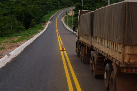
Avenida Perimetral Portuária in Santos - The works and services of readjustment of the Perimetral Avenue of the right-bank, in the section between channel 4 and Ponta da Praia, comprising the adaptation of the Mário Covas Júnior Avenues, known as Avenida Portuária, and Ismael Coelho de Souza, the so-called inner avenue is in progress. One of the main objectives of the work is to implement a set of two viaducts to avoid the road-rail conflict, solving a significant bottleneck between container and bulk traffic. With the implementation of this complex of viaducts, it will segregate the road traffic between vehicles of containers and grains and bran. The project also contemplates the transfer of the railway lines of access to the Export Corridor of Solid Bulk of Vegetal Origin, which now pass in the middle of the terminals.
Avenida Perimetral Portuária in Santos - 2nd port entrance - The functional project was revised by CODESP to adapt the use of the areas of influence, aiming at improving road access and solving the road-rail conflict in the Valongo region to provide an alternative port entrance and exit of vehicles in case of closing / blockade of Avenida Eng. Augusto Barata, in Alemoa.
Duplication of road access to Barnabé Island - Elaborated a functional project, Terms of Reference and budget worksheet for the contracting of an executive project to adapt road access to Barnabé Island, consisting of the implementation of a new lane with approximately 2,700 m extension and recovery / renovation of the existing lane with shoulder on both sides, thus allowing road access with two entrance lanes and two exit lanes. The project also includes the construction of a bridge over the Diana River with approximately 110 meters in length and a viaduct over the Sandi River with about 300 meters in length.
Avenida Perimetral Portuária in Guarujá - 2nd Phase - The project will ensure the segregation of traffic, and will significantly improve the movement of cargo, increasing the safety of urban traffic. The project also includes the construction of a cable-stayed bridge over the Cônego Domênico Rangoni Highway and the construction of a viaduct on Santos Dumont Avenue.
Railways
Main Railway Operators: MRS, VLi and RUMO.
The Port of Santos has an internal railway network with 100 kilometers of extension. This mode of transport accounts today for about 27% of the transportation of cargo handled in the Port of Santos. This participation has been increasing every year and intensified since the creation, in 2015, of a working group called "Master Plan of Baixada Santista", integrated by MRS, VLi and Rumo, where railroads deal with the investments required for resolution of problems verified in the rail accesses of Baixada Santista and terminals, unifying the operational procedures and the planning in the customer service in the short, medium and long term. The agribusiness loads are the most benefited using the railroad in the Port of Santos, because 53% are transported by this mode.
Revitalization of the rail network: Several interventions in the internal rail network of the Port of Santos were carried out to increase cargo receiving capacity, such as the revitalization of the permanent route which, among other actions, promoted the replacement of old rail lines with new ones with greater support capacity, allowing the arrival of loaded wagons with more goods and increasing traffic speed and operational safety, reducing the potential for accidents due to derailment.
Port Security
Separate container and grain terminals are lined along the coastal line of Sao Vicente and Santo Amaro Islands for kilometers so there is no unified port territory. For container terminals, all have ISO certifications and DP World additionally has ISO 28001 certification. All gates are monitored, guarded, terminal area covered with fences. Grain Terminals are holding security very seriously as well. Terminal gates are guarded, monitored and terminal borderline is fenced and in case you need to access to wharf area then you need to have a prior authorization from CODESP to access a secondary gate patrolled by Santos Port Guard. The Port Guard, under authority of CODESP, is responsible for security and patrimonial surveillance, and its work extends to public port security actions, access control - people, vehicles and cargo, internal traffic, prevention and repression of illicit activities.
Port Guard has an operational staff of 400 members, distributed in two managements. The Intelligence and Security Department is responsible for the monitoring and control of accesses (ISPS Code) and for capturing information and data for forecasting and planning of actions, while the Security Operation handles the logistics of activities involving equipment, weapons, ammunition, vehicles and transit of vehicles in the Organized Port area.
Access control is performed through 37 gates distributed along the port docks, as well as 16 other surveillance points outside the so-called restricted areas.
|
Security |
|
|---|---|
|
ISPS Compliant |
Yes |
|
Current ISPS Level |
Level 1 |
|
Police Boats |
Yes |
|
Fire Engines |
Yes |
2.1.2 Brazil Port of Itacoatiara
Port Overview
Itacoatiara is the 2nd largest town in the Amazonas State, on the left bank (looking downriver) of the Amazon River near the mouth of Madeira River. Its population was 95,714 (2014) and its area is 8,600 km². The town is known as "City of Painted Stone" - which is its name translated from Tupi.
Itacoatiara is located 108 nautical miles downriver from Manaus. It takes roughly 51 hours upstream transit time leaving Fazendinha pilot station for the vessel to reach Itacoatiara-AM, and 42 hours downstream. Terminals are about 800 miles inland (600 miles from Pilot Station, Fazedinha). Panamax vessels can make the journey from the Atlantic Ocean up to Amazon to Itacoatiara in 3 days. The depth alongside the terminal can reach 30 meters during flooding, but there is draft restrictions at Amazon River’s mouth, called Barra Norte (Ponta do Céu) which is 11.50 meters. With further dredging it is soon expected to be increased to 11,70 metres.
Although it can vary a lot, an average of 8 days at anchorage needs to be considered before berthing. During rainy season which is from December till June, operations is halted couple hours of a day for almost all days. The following are terminals at Itacoatiara.
Floating Hermasa Terminal I
For soya beans, soya meal, maize and soya oil.
Hermasa can load Panamax Size vessels, through two steady ship loaders and conveyor system from warehouses or from barges. It is not allowed to drop anchor.
Hermasa Anchorage Terminal II
System of buoys complex – for soya beans, maize, and discharges fertilizer.
Transhipment operation is performed at inner anchorage of Itacoatiara roads – close to Hermasa floating terminal. The vessel will stay moored on five buoys: 3 ones at forward and 2 ones at afterpart, not allowed dropping anchors. The Crane assembled on top of a Barge will be moored alongside the vessel, where the loading will be performed by a grab linked to the Crane.
Terminal Fluvial do Brasil (TFB)
TFB is for for liquid products. Liquid cargo is discharged from the vessel (diesel, ethanol and gasoline) and stored in the shore tanks, for later transfer to the barges that will distribute products in the cities of the area (Parintins and Porto Velho).
Novo Remanso
It is a public berth for general cargo and passengers.
Port website: https://www.amaggi.com.br/en/business/logistics-and-operations/
Key port information may also be found at: http://www.maritime-database.com
|
Port Location and Contact |
|
|---|---|
|
Country |
Brazil |
|
Province or District |
State of Amazonas |
|
Nearest Town or City with Distance from Port |
Itacoatiara - 10 KM |
|
Port's Complete Name |
Port of Itacoatiara |
|
Latitude |
-3.1429 |
|
Longitude |
-58.4439 |
|
Managing Company or Port Authority |
Amaggi – Hermasa (only for grain terminal) |
|
Management Contact Person |
n/a |
|
Nearest Airport and Airlines with Frequent International Arrivals/Departures |
Eduardo Gomes International Airport – Manaus American Airlines, Copa Airlines, TAP Airlines, LATAM, AZUL, GOL |
Port Picture
Hermasa I (Amaggi Terminal)

Itacoatiara (Hermasa I on the left side of the photo)
Description and Contacts of Key Companies
Please find photos, videos and additional information in following link: Itacoatiara Documents
Amaggi Hermasa I & II Grain Terminals
Hermasa Terminal I / Floating unit
Hermasa is in the Itacoatiara city area, linked to Manaus via paved road 270 km far. The System can load Panamax Size vessels, through two fixed ship-loaders and conveyor system either from shore silos, from the barges and or both.
The terminal is about 800 miles inland (600 miles from Pilot Station, Fazendinha). Panamax vessels can make the journey from the Atlantic Ocean up to the Amazon to Itacoatiara in 3 days. The depth alongside the terminal can reach 30 meters during flooding, but there are draft restrictions at Amazon River’s mouth, called Barra Norte (Ponta do Céu) which is 11,50metres. The terminal comprises a twin-hull (catamaran) floating pier, roughly 70 meters long by 14 meters wide, with two steady ship-loaders. Convoy of barges (25x2,000T=50,000 tons;) carrying the soybeans and/or maize sailing from the Porto Velho terminal through the Madeira River can be docked inside the floating pier and their cargo transferred to silos ashore or directly into the ship's cargo holds both ways measured by scales. The barge gantry unloader can handle up to 1,500 MT/hr of cargo.
Grain Terminal Located at Latitude 03° 09' 368" Longitude 58° 26' 722" consists of:
- Floating unit
- Grain products reception by barges
- Storage (Solid and liquid)
- Crushing plant
- Loading grain
Floating Unit: Considering the huge variation of the Amazon River subject to rainy season on Dec/June the ship- loader was built on top of a floating unit linked ashore by a bridged conveyor system, the floating unit is kept in position by a system of 7 anchors. Vessels under loading operation do not berth alongside the floating unit but are moored properly to the 7 buoys and 2 mooring bits ashore. The ships are positioned about 3 meters distant from the floating unit using tension on the various moorings. There is a tug stationed always on the upriver end of the floating unit to assist in manoeuvring and in the case of emergencies.
Number of gangs intended to be employed, expect number of shifts and stevedore working hours: 2 gangs (occasionally can be used simultaneously) / number of shifts: 5 / every 6 hours.
| Vessel Maximum LOA | 255 m |
|---|---|
| Maximum beam | 32.30 m |
| Vessel max air draft |
15.00 m |
|
Maximum sailing draft |
11.50 Meters
|
| Loading Rate | 2 loaders simultaneously can reach 2.300 MT/hr for grains. |
| SBS Capacity |
1.5 MT/hr Maize:1.5 MT/hr Oil: 550 MT/hr SB HIPRO:: 700 MT/hr |
| Stowage Factor SBS |
Official figures by Customs Shore scale figures only. |
| Working periods | 24 Hours Sat/Sun/Holidays included. |
| Manoeuvre periods | Daylight only |
| Mooring |
Mooring: 05:30 AM – 04:30 PM Unmooring: 07:00AM – 05:30 PM |
| Berth fendering/mooring arrangements | Berth fendering is considered proper for vessels up to Panamax categories – however, it is small fendering system / mooring arrangements always to be performed on board, once the vessel is at the anchorage area by Terminal’s mooring master. |
| Fresh water supply | Available, min supply 100 tons, USD 13.00 per ton. |
| CTM | Not available |
| Workshop | Mechanic and electrical maintenances in diesel high rotation engineering motors, shaft maintenance and others. |
| Availability of sludge for disposal | Free of charge. Performed by barge and inner anchorage only. |
| Garbage removal | Available/ Not compulsory. |
| Shore labour | boarding by portside gangway. |
| DWT/Displacement Restriction | Up to 100,000 tons. |
There is an anchorage close to Itacoatiara town and the main public pier which is used solely for inter river traffic. The depth of water at the anchorage varies with the rainy season and can range from 35.0 to 75.0 meters.
Barge Transportation
Soya beans and maize are supplied to Hermasa Grain Terminal by a system of 135 Mississippi style barges and five (5) pusher tugs. Each convoy consists of twenty (25) barges pushed by a tug. Porto Velho is approximately 1,100 kms from Itacoatiara sailing in the Madeira River. The barges are all secured/covered with fiber-glass covers and all cargo is sampled and tested before being stored and or/ loaded as well as shore weighted.
Storage:
- 2 Warehouses of 110,000 tons each (Soya/Maize).
- 1 Warehouse of 110,000 tons for soya meals.
- 8 Tanks (Soya oil) - Totalling 25,000 tons.
Crushing Plant: 2,000 tons per day, producing 1,600 tons of soya meal, hull pellets and 400 tons raw soya oil.
Loading Rates
- Soybeans or maize - 1,500 tons p/h provided, there are barges for the 2nd loader otherwise 1,000/ 1,500 tons p/h from storage.
- Soya meals/Pellets - 700 tons p/h - one loader only.
- Soya oil - 550 cbm p/h (hoses connection 2x 6”).
Loaders – 2 steadies, but it turns around and operates both provided barge availability – outreach 18.0 meters.
Bunkers – N/A - nearest ports where Bunker is available: Belem or Manaus
Tugs boats – 2 in/out
Mooring Lines Terminal can supply vessel with additional ropes free of charge if required/ approved by them.
Macapá Bay Anchorage Macapá Bay Anchorage positions for waiting Vessel’s repairs and Quarantine formalities.
Macapá Anchorage no. 01:
- A) 0º06,65'N 50º 56,90'W
- B) 0º08,00'N 50º 55,47'W
- C) 0º08,00'N 50º 53,96'W
- D) 0º06,65'N 50º 54,92'W
Macapá Anchorage no. 02:
- A) 0º02,20'N 50º 59,47'W
- B) 0º04,57'N 50º 58,36'W
- C) 0º04,57'N 50º 56,83'W
- D) 0º02,20'N 50º 57,87'W
Fazendinha Anchorage Compulsory pilots board at Fazendinha P/S, 300nm away from Santarém.
Alternative Anchorages at Fazendinha P/S.
- A) 00º 03.5 S 051º 07.2 W
- B) 00º 03.5 S 051º 05.8 W
- C) 00º 03.7 S 051º 05.8 W
- D) 00º 04.3 S 051º 06.9 W
Local Times:
Fazendinha P/S GMT -3h
Santarem GMT -3h
Itacoatiara GMT -4h
Note some distances for your reference:
From Amazon River entrance (Barra Norte) up to Macapá 170 NM
From Macapá to Santarem 300 NM
From Macapá P/S to Itacoatiara 610 NM
From Itacoatiara to Manaus 110 NM
Hermasa II (MAQUIRA)
Transhipment through barges
Transhipment will take place inner anchorage of Itacoatiara – closest to Hermasa floating terminal.
| Barge Name | Cuiaba |
|---|---|
| LOA | 61 m |
| Beam | 22 m |
| Sailing draft as per Barra Norte Restriction | 1150 m |
| FW Density | 0.998 |
| Draft in the anchorage | 80.00 m |
| Grabs / Capacity |
2 available, but only 1 working at a time 26 Tons / 500 Tons/hr |
| Air draft | 17.00 m Panamax-sized vessels |
|
Anchorage Name |
Maquira |
| Loading Rate | – 10/12.000 Tons. p/d |
| B/L Figures | Final loaded quantity (B’s/L figures) will be determined by draft survey conducted by Custom’s appointed surveyor. |
| Berthing/unberthing maneouvres | During daylight only – from 0600lt to 1730 LT (for berthing vessel must heavy up anchor max 1500 LT, in order to reach Terminal in time.). |
| Mooring system | – Vessel will stay moored on four buoys – 3 forward and 1 aft, so not required dropping anchors and the Crane Barge will be moored alongside the vessel – as per below. |
| Bunkers | N/A. Belem or Manaus are the nearest ports where bunker is available |
| Fresh Water | N/A |
Port Authorities and agency staff will board vessels at both ports (Fazendinha P/S and Itacoatiara). At Fazendinha P/S the visit/inspection takes about 3 hours to be performed.
Terminais Fluviais do Brasil (TFB)
TFB has a large capacity of oil storage of 59.000 cubic meters, typically transfers the storage oil to other points. TFB is part of a DISLUB EQUADOR group.
Port Performance
|
Seasonal Constraints |
||
|---|---|---|
|
Occurs |
Time Frame |
|
|
Rainy Season |
Yes |
December to June |
|
Major Export Campaigns |
Yes |
December to September |
|
Other Comments |
N/A |
|
|
Handling Figures for 2017 |
|
|---|---|
|
Vessel Calls |
105 (excluding Tank Terminal, only Hermasa I & II for solid and liquid bulk) |
|
Container Traffic (TEUs) |
NIL |
|
Handling Figures Bulk and Break Bulk for 2017 |
|
|---|---|
|
Bulk (MT) |
4,663,641 (HERMASA I&II only) |
|
Break bulk (MT) |
NIL |
Discharge Rates and Terminal Handling Charges
https://www.amaggi.com.br/en/navigation-rates/
Berthing Specifications
|
Type of Berth |
Quantity |
Length (m) |
Maximum Draft (m) |
Comments |
|---|---|---|---|---|
|
Conventional Berth |
1 |
|
|
Novo Remanso Public Berth for small river cargo and passenger transportation. |
|
Container Berth |
N/A |
|
|
|
|
Silo Berth |
1 |
255 m |
11.5 m |
Hermasa I Floating Unit |
|
Berthing Tugs |
Yes |
|
|
|
|
Water Barges |
Yes |
|
|
|
General Cargo Handling Berths
|
Cargo Type |
Berth Identification |
|---|---|
|
Imports - Bagged Cargo |
N/A |
|
Exports - Bagged Cargo |
N/A |
|
Imports and Exports - RoRo |
N/A |
|
Other Imports |
N/A |
Port Handling Equipment
The port equipment is managed by the terminal owners.
|
Equipment |
Available |
Total Quantity and Capacity Available |
Comments on Current Condition and Actual Usage |
|---|---|---|---|
|
Dockside Crane |
N/A |
|
|
|
Container Gantries |
N/A |
|
|
|
Mobile Cranes |
N/A |
||
|
Reachstacker |
N/A |
||
|
RoRo Tugmaster (with Trailer) |
N/A |
|
|
|
Grain Elevator |
Yes |
2 Fixed Vessel Loaders with moving arms each with 1500 TPH Loading Rate, loading via 1 loader at a time |
Hermasa I floating unit |
|
Transtainer |
N/A |
|
|
|
Forklifts |
N/A |
|
|
Container Facilities
There is no container terminal in Itacoatiara.
Customs Guidance
Customs Authority: Delegacia da Receita Federal no Amazonas
There is no customs authority in Itacoatiara, Manaus Customs Authority oversees exports and imports from Itacoatiara Port. All customs process is done in a paperless environment on a electronic platform named e-CAC. Please see this link for guidance on e-CAC (in Portugese): e-CAC Guidance.
Address: Avenida Governador Danilo de Matos Areosa, 1530, Distrito Industrial 1, Manaus, Amazonas CEP 69075-351
Tel: +55(92)32335180
Terminal Information
Multipurpose Terminal
|
Storage Type |
Number of Storage Facilities |
Area (m2) |
|---|---|---|
|
Bagged Cargo |
None |
N/A |
|
Refrigerated Cargo |
None |
N/A |
|
General Cargo |
None |
N/A |
Stevedoring
All stevedoring activities are carried out by the terminal owners. Amaggi has a shipyard in Itacoatiara for maintenance of its tugboat and barge fleet. No bunkering service is available in Itacoatiara. Closest options are Manaus or Belem. Sludge and garbage disposal services are available.
Hinterland Information
Main means of connection of the terminals is Amazon River and its branches. Majority of grain volumes are coming from State of Mato Grosso using Brazilian Highway System till Porto Velho (BR-364) and there they are transhipped to barge convoys (25x2000 tons barge) which takes them 3-4 days to arrive to Hermasa Terminals in Itacoatiara with Madeira River / Amazon River connection.
Port Security
|
Security |
|
|---|---|
|
ISPS Compliant |
Yes |
|
Current ISPS Level |
ISPS Level 1 |
|
Police Boats |
No |
|
Fire Engines |
No |
2.1.3 Brazil Port of Santarem
Port Overview
Santarém is a city and municipality in the western part of the state of Pará in Brazil. Located at the confluence of the Tapajós and Amazon Rivers, it has become a popular tourist destination. It is the second-most important city in the state, and the financial and economic centre of the western part of the state. It leads the Santarém Metropolitan Area, made up of Santarém, Belterra and Mojuí dos Campos.
It is located some 800 km (500 miles) from the two largest cities in the Brazilian Amazon: Manaus, upriver in the state of Amazonas, and the Pará state capital Belém, located downriver at the mouth of the Amazon on the Atlantic Ocean. Santarém has an estimated population of 299,419 people (2012 Census) and is the third most populous city of the state. The city occupies an area of 22 887,087 km2² (14 304,42 square miles), of which 77 km2 are urban areas.
There are proposals to create a new Brazilian state by dividing the enormous state of Pará into western and eastern regions. The new state to be established in the west would be called Tapajós, with Santarém serving as the capital.
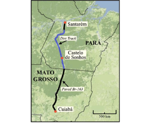
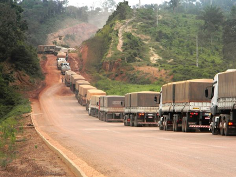
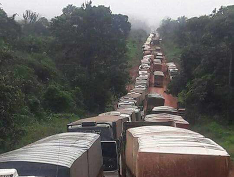
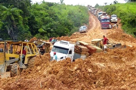
BR-163 connects Santarém with the southern Brazil. A large portion of it is not paved which renders the highway nearly unusable during the wet season. BR-230 connects BR-163 to the state capital.
Santarém is a popular destination for cruise ships on the Amazon, which make port regularly in the City Docks. The docks are administrated by the CDP (Companhia Docas do Pará) and are the second most important in the state, second only to Belém, due to its proximity to the Atlantic Ocean. The rivers and waterways are still the central means of transporting passenger and cargo due to the poor conditions of the highways and the high price of airplane travel. Most nearby villages have no roads and can only be reached by boat; trips can take up to 12 hours depending on the boat and the destination.
In 2003, the US-based corporation Cargill completed a port facility for processing soybean in Santarém which has stimulated soybean production in the area but has received backlash due to its non-compliance with environmental regulations.
Port website: http://www.cdp.com.br/porto-de-santarem
Key port information may also be found at: http://www.maritime-database.com
|
Port Location and Contact |
|
|---|---|
|
Country |
Brazil |
|
Province or District |
State of Para |
|
Nearest Town or City with Distance from Port |
Santarem – 0 km |
|
Port's Complete Name |
Porto de Santarem |
|
Latitude |
-2.42939 |
|
Longitude |
-54.73816 |
|
Managing Company or Port Authority |
Companhia Docas Do Para |
|
Management Contact Person |
José Carlos Zampietro |
|
Nearest Airport and Airlines with Frequent International Arrivals/Departures |
Santarem – Maestro Wilson Fonseco Airport has only local flight connections with TAM, AZUL and GOL Airlines. Nearest airport with international connections would be Eduardo Gomes International Airport in Manaus. American Airlines, Copa Airlines, TAP Airlines, LATAM, AZUL, GOL |
Port Picture
Cargill Terminal on the right-side and CDP Public Berths on the top-side.
Cargill Santarem Grain Terminal
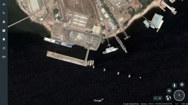
CDP Santarem Public Berths
Description and Contacts of Key Companies
Please check following link for Santarem photos, videos and additional documents: Santarem Documents.
Cargill Santarem Grain Terminal
Website: https://www.cargill.com.br/pt_BR/santar%C3%A9m
In 1999, Cargill won the concession to build a grain terminal in Port of Santarém. The construction of the Cargill Terminal began in 1999 and its operation began in 2003. The Santarém Solid Granulated Fluvial Terminal was built to ship part of the grain production acquired by Cargill in the central-western region of Brazil (Mato Grosso), and allowed the local community the possibility export their production.
Currently the Terminal moves soy and maize, operating through road and waterways. More than 80% of the grain travels from Mato Grosso to Porto Velho (RO) or Miritituba (PA) in trucks, where they are later transhipped to the barges for Santarém destination. Another 20% arrive at the terminal in trucks coming directly from the state of Mato Grosso by Br-163 highway or local production. The current capacity for shipment is 5 million tons of grain per year and storage of 114 thousand tons since expansion project of 2015 is completed.
Cargill Terminal is located in the Santarem city on right bank of Tapajos River. About 300nm from Fazendinha P/s. Fazendinha P/s is the first stop for all vessels entering Amazon River for Port Authorities clearance purposes and Pilots embarkation/disembarkation. The System can load Panamax Size Vessels, through three fixed Ship loaders and conveyor system either from shore silos, from barges and/or both.
| Max LOA | 250 m |
|---|---|
| Max Beam | N/A |
| Max draft at berth |
18.00 m (February- July) 12.00 m (August-January) |
| Max air draft | 15.00 m |
| DWT | 120.00 MT |
| Max sailing draft | 11.55 m |
| Loaders | 3 units |
| Water Density | 0.996 - FW |
| Stowage factor |
Corn: 46 cubic ft/MT SBS: 48.5 cubic ft/MT |
| Departure max draft from Cargill terminal | 11.55mts but draft limitation at Barra Norte/Ponta do Céu is 11.5 meters. FW. |
| Loading Rate | Soybeans and corn in bulk about 1.100 MT/h for each loader. Loading operations can be done by 2 Shore Loaders at same time. |
| Ship Loaders | 3 steady but turn around and operates two each time – outreach 18.0 meters |
| Storage |
114,000 Tons (Total)
|
| Bunkers | Not available |
| Tug boats | Compulsory with 2 tugs – Mooring/Unmooring |
| Anchorages and Pilot Station |
|
| Local Times | Fazendinha P/S GMT -3h. Santarem GMT -3h. |
| Some distances for your reference | From Amazon River, entrance (Barra Norte) up to Fazendinha P/S is 170 NM. From Fazendinha P/S to Santarem is 300 NM. |
CDP Santarem Public Berths
Website: http://www.cdp.com.br/porto-de-santarem
The Port of Santarém covers an area of 498,370.89 m². (including Cargill Terminal)
Mooring structures: It has 8 berths consisting of pier, mooring dolphins, fluvial pier, solid bulk terminal, three liquid bulk terminals and Ro-Ro ramp.
Pier 100: L-shaped, "pre-shaped" concrete construction, built on precast concrete, built on reinforced concrete, built at the end of the access bridge, has two berths 101 and 102 with 200m and 185m in length, for general cargo and solid bulk. The pier was designed for overload of 3.0 t / m².
Mooring dolphins 200: consisting of a set of four mooring dolphins and a mooring dolphin, structures set on inclined piles executed in reinforced concrete, located upstream and in the same alignment of the pier 100, forming the cradle 201 with 185.6 m of extension for solid bulk operation and the cradle 202 of the same dimensions, is for barges, but it is not operational.
Fluvial Pier 300: situated in the inner area of pier 100, has a berth 301 prepared to receive mixed fluvial vessels of passengers and general load.
Terminal of Solid Bulk 400: CARGILL Terminal Concession, located downstream of pier 100, is equipped with a conveyor belt in metallic structure with 374m in length that connects the mainland to the berthing structure which is composed of five mooring dolphins for operations with ships and barges. Cradle 401 intended for operations with ships and cradle 402 intended for operations with bulk barges.
River ramp - RF: ramp provided for barge operations in the "ro-ro" system, located on the right bank of the fluvial pier, prepared in a natural soil made of lateritic material (piçarra), with a width of 70m.
Liquid Bulk Terminals Concessions
T01: leased terminal to Fogás has a berthing platform built in concrete structure, an access bridge in metallic structure and pipelines for transportation of fuels.
T02: terminal leased to Raizen Shell, built in a wooden structure, has a connected two-berth docking platform and an access bridge that houses the fuel transport ducts.
T03: terminal leased to Equador, built in a wooden structure, has a connected two-berth docking platform and an access bridge that houses the fuel transportation ducts.
Storage
In addition to Cargill Terminal, the port has the following facilities:
Warehouses: two warehouses with lateral closure, measuring 60.0m x 25.0m each, occupies a total area of 3,000 m².
Gapões: two sheds with no lateral closure with an area of 1,200 m²
Customs Patios: Paved courtyard with asphalt concrete with an area available for storage of 10,000 m² and a paved courtyard with reinforced concrete with an area prepared for storage of 4,250 m².
Patios Storage: Paved patio with interlocking concrete blocks, located in the customs clearance area, has available storage area of 6,326 m²
BERTHS 101&201
Berth 101 - Max Dwt: 30,000 mt (Registered DWT) - By using trucks operations.
Berth 201 (5 Dolphins) - Max Dwt: 55,000mt (Registered DWT) - By using barges operations.
Max LOA 200.00mt / Max beam N/A / Max sailing draft 11.55mt / Max DWT 30k/ 55k / Operation Loading/ unloading grains / Fertilizers / Discharging / Loading rate average SBS - 500mt / day Fertilizer - 500mt/ day / Official figure Shore scale at BERTH 1 Vessel’s draft survey at BERTH 2/ 5 dolphins Water density 0.996/ 0.998 / Berth size Max 200.00mt / Depth at berth 15.00mt (low season of the river) Working times 24 hours daily/ 07 days in week / Tugboat Compulsory / Bunker Not available / Port crane/ grabs Only grabs available / FW supply By shore hydrants (10mt/hour) / Garbage removal Not available / Berthing/ unberthing manoeuvres The manoeuvres can be performed during day and night time and there is no restriction. The manoeuvre will be assisted by boats to help with lines / Pilotage station Pilotage from Barra Norte (entrance of Amazon river) up to Fazendinha P/S is not compulsory. This transit is master self-pilotage as per buoyage/ delimited channel informed to Masters / Warehouse There are 2 warehouses for general cargoes with total area 5,510 m3 / Local time GMT - (minus) 03hours.
Departure max draft from CDP terminal is 11.55mts but draft limitation at Barra Norte/Ponta do Céu is 11.5 meters FW.
Port Performance
|
Seasonal Constraints |
||
|---|---|---|
|
Occurs |
Time Frame |
|
|
Rainy Season |
Yes |
December to June |
|
Major Export Campaigns |
Yes |
February to November |
|
Other Comments |
Soybeans February to July / Maize July to January |
|
|
Handling Figures for 2017 |
|
|---|---|
|
Vessel Calls |
104 (Only Solid Grain shipments from Cargill and Public Berths) Grand total (including barges and river boats) 3,445 |
|
Container Traffic (TEUs) |
NIL |
|
Handling Figures Bulk and Break Bulk for 2017 |
|
|---|---|
|
Bulk (MT) |
4,577,210 (solid grain shipments only) |
|
Break bulk (MT) |
155,851 |
Discharge Rates and Terminal Handling Charges
Cargill Santarem Grain Terminal: https://www.cargill.com.br/pt_BR/santar%C3%A9m
CDP Public Berths: https://www.cdp.com.br/tarifas-portuarias
Berthing Specifications
|
Type of Berth |
Quantity |
Length (m) |
Maximum Draft (m) |
Comments |
|---|---|---|---|---|
|
Conventional Berth |
2 |
400 |
15 (dry season) |
CDP Berths 101&201, max sailing draft: 11.55 meters |
|
Container Berth |
NIL |
|
|
|
|
Silo Berth |
1 |
250 |
12 dry season / 18 wet season |
Cargill, max sailing draft: 11.55 meters |
|
Berthing Tugs |
Yes |
|
|
2 compulsory during mooring & unmooring |
|
Water Barges |
Yes |
|
|
|
General Cargo Handling Berths
|
Cargo Type |
Berth Identification |
|---|---|
|
Imports - Bagged Cargo |
CDP Public Berths 101&201 |
|
Exports - Bagged Cargo |
CDP Public Berths 101&201 |
|
Imports and Exports - RoRo |
NIL – There is a berth for ferry barge but only for domestic cargo. |
|
Other Imports |
Port Handling Equipment
Port handling equipment is privately-owned by terminal concession owners or stevedoring companies operating at public berths.
|
Equipment |
Available |
Total Quantity and Capacity Available |
Comments on Current Condition and Actual Usage |
|---|---|---|---|
|
Dockside Crane |
Yes |
2 (Not operational) |
CDP Berth 101 |
|
Container Gantries |
No |
|
|
|
Mobile Cranes |
No |
||
|
Reachstacker |
No |
||
|
RoRo Tugmaster (with Trailer) |
No |
|
|
|
Grain Elevator |
Yes |
3 Loaders of which 2 can load simultaneously with 1,100 MT/hr loading rate for a total of 2,200 MT/hr |
Cargill Terminal |
|
Transtainer |
No |
|
|
|
Forklifts |
Yes |
|
|
Container Facilities
There is no container handling facility in Santarem Port.
Customs Guidance
Customs Authority: Delegacias da Receita Federal No Para
All customs process is done in a paperless environment on a electronic platform named e-CAC.
Address: Av. Tapajós, 277 Centro Santarem, PARA CEP 68005-000
Tel: +55(93)35125400
Please seePort of Santos Customs Guidance for Brazilian Customs Orientation Document(in Portuguese).
Terminal Information
Multipurpose Terminal
|
Storage Type |
Number of Storage Facilities |
Area (m2) |
|---|---|---|
|
Bagged Cargo |
2 |
4,200 |
|
Refrigerated Cargo |
N/A |
|
|
General Cargo |
1 |
6,326 |
Stevedoring
All stevedoring activities are carried out by the terminal owners and private stevedoring companies operating at public berths No bunkering service is available in Santarem. Closest options are Manaus or Belem. Sludge and garbage disposal services are not available. FW supply available.
Hinterland Information
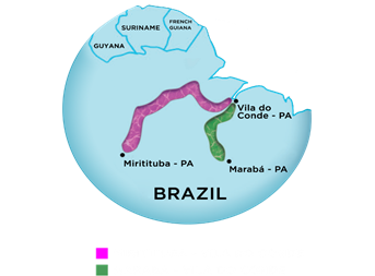
Main means of connection of the terminals is Amazon River and Tapajos River as Santarem is perfectly located in the junction point. Majority of grain volumes are coming from State of Mato Grosso using notorious BR-163 Cuiaba – Santarem partly paved highway till Miritituba Port on Tapajos River and there they are transhipped to river barges for further transportation till Cargill and CDP Berths in Port of Santarem. During June-December dry season part of the volumes arrive via overland using BR-163 Highway all the way till Santarem. Additionally, just like Itacoatiara Porto Velho which is connected to Mato Grosso via BR-364 Highway for further river transportation via Madeira River is another supporting port for volumes that are being exported from Santarem.
Photos of BR-163 Cuiaba Santarem Highway
Port Security
|
Security |
|
|---|---|
|
ISPS Compliant |
Yes |
|
Current ISPS Level |
ISPS Level 1 |
|
Police Boats |
Yes |
|
Fire Engines |
No |
2.1.4 Brazil Port of Barcarena (Vila Do Conde)
Port Overview
Barcarena is a Brazilian municipality in the state of Pará adjacent the Tocantins River. It has a population of 102,015 and is part of the Belém metropolitan area. The city's economy relies largely on agriculture and bauxite. There are also facilities for pig iron nearby. They city and port are developing as a major transhipping port, speeding up shipment and reducing time and costs as opposed to traditional mega ports in the Southeast.
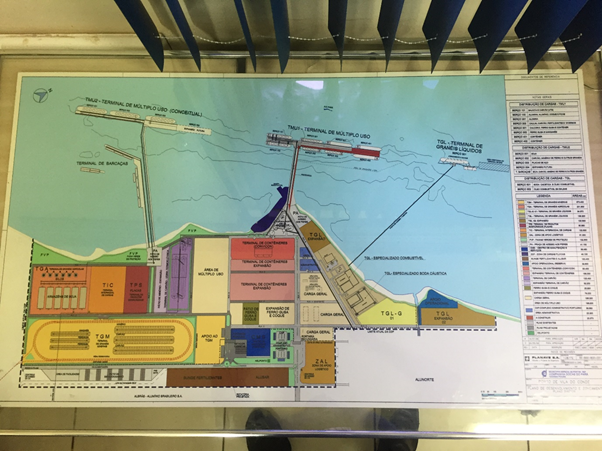
Opened by Companhia Docas do Pará (DP), on October 24, 1985, The Port of Vila do Conde, located in Ponta Grossa, municipality of Barcarena, State of Pará, on the right bank of the Pará River, at a distance of 55 km from Belém and about 3.3 km downstream from Vila Murucupi, new denomination of the old Vila do Conde, in front of the bay of Marajó, formed, among others, by the confluence of the rivers Tocantins, Guamá, Moju and Acará. It is integrated with the Industrial Port Complex of Vila do Conde.
Many factors transform the port into an efficient connection of the region with the rest of the world in view of its strategic geographic position, as well as the large extension of liable front with its 10 mooring berths with depth between 12 m to 23 m, rivers and roads, and a wide availability of areas for expansion.
The industrial complex adjacent to the port area is Alumínico Complex consisting of the units of Alunorte - Alumina do Norte do Brasil SA, Albrás - Alumínio Brasileiro SA, Alubar - Alumínios de Barcarena SA, as well as Imerys Rio Capim Caulim Kaolin Processing Plant & Terminal and Terfron, Hidrovias and TGPM Grain Terminals. Imerys and mentioned grain terminals have their own separate gates, road connections and berths apart from CDP Port of Vila Do Conde. Alumínico Complex and Santos Brazil Tecon Vila do Conde Container Terminals are using CDP Vila Do Conde public berths which are reserved for them.
Port website: http://www.cdp.com.br/porto-de-vila-do-conde
Key port information may also be found at: http://www.maritime-database.com
|
Port Location and Contact |
|
|---|---|
|
Country |
Brazil |
|
Province or District |
State of Para |
|
Nearest Town or City with Distance from Port |
Barcarena – 19.6 kms |
|
Port's Complete Name |
Porto de Vila do Conde |
|
Latitude |
-1.541364 |
|
Longitude |
-48.746387 |
|
Managing Company or Port Authority |
Companhia Docas Do Para (CDP) |
|
Management Contact Person |
Antônio Carlos de Brito Barbosa |
|
Nearest Airport and Airlines with Frequent International Arrivals/Departures |
Val de Cans – Belem International Airport TAP, AVIANCA, LATAM, SURINAM AIRWAYS, AZUL, GOL |
Port Pictures
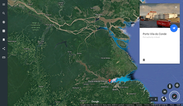
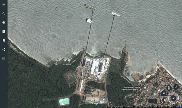
Amazon River Mouth on the Northside, on the South Belem and Port of Vila do Conde (Barcarena) and Marajo Island in between.
Belem – Barcarena – Vila Do Conde Overview (Port on upper left).
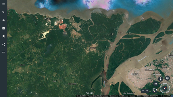
Private grain terminals on the left & right sides, and the CDP of Port of Vila Do Conde in the middle, behind the Vila Do Conde Port Aluminico complex.
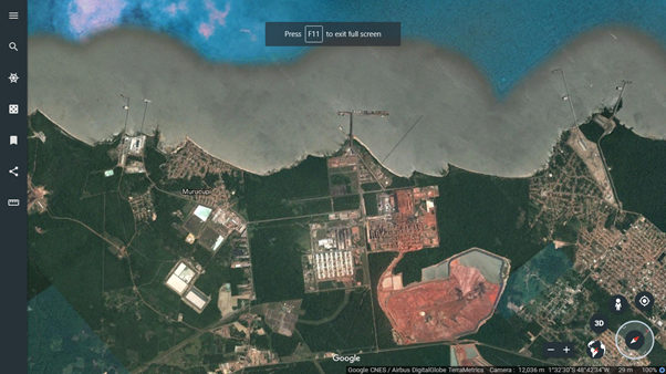
Terfron Grain Terminal owned by Unitapajos JV of Bunge & Amaggi on the right side / Hidrovias Grain Terminal on the left.
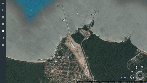
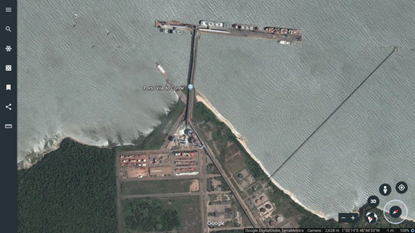
Companhia Docas Do Para (CDP) Port of Vila Do Conde where Santos Brasil Container Terminal is located, servicing the Aluminico Complex which was opened in 1985.
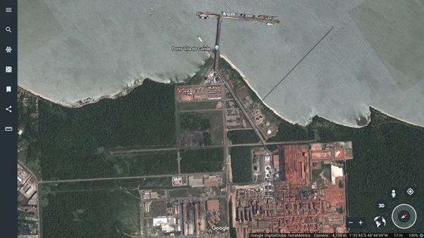
Closer view of the CDP Port of Vila Do Conde.
TGPM Grain Terminal A JV of ADM & Glencore on the left side,
Imerys Caulim Kaolin processing plant on the
right.
Description and Contacts of Key Companies
Please find following link for Barcarena Port & Terminal photos, videos and documents: Barcarena Documents.
Unitapajos Terfron (Terminal Fronteira Norte Logistica S.A.) Grain Terminal
Unitapajos is a Bunge & Amaggi JV with the focus on developing Northern routes for moving grains cultivated in Mato Grosso. Unitapajos is also owner of a transhipment terminal in Miritituba on Tapajos River where grain shipments are further connected to Terfron via barges. Terfron can receive grains via trucks and barges. Vessels reach Terfron via Quiriri Access Channel that has an official draft of 13.3 meters.
| Max Draft Allowed | 13.3 meters |
|---|---|
| Max Channel Draft | 14 meters |
| Mooring | Starboard side |
| Cargo Trimming | Spout trimming |
| Loading Rate |
1,500 Tons/hr for soya beans and maize 750 Tons /hr for soya meals |
| Official Bs/L Figures | Shore scale |
| Bunkers | Not permitted |
| Fresh Water Supply | Unavailable |
| Tug Boats | 3 Tugs in + 2 Tugs out (compulsory) |
| Local Times | Mosquiero Pilot Station GMT -3H, Vila Do Conde GMT -3H |
| Working Times | 24/7, Holidays included |
| Berth Length | 131 meters |
| Distance between fenders | 80, then 50 meters |
| Distance between dolphins | 263 meters |
| Air draft | 22 meters |
| LOA Restriction | 240 meters |
| Beam Restriction | 38 meters |
| Dead Weight | 120,000 MT |
| Displacement | 93,100 MT |
| SHIPLOADERS | (Max outreach): 3 towers, working one at a time (25 meters) |
All people involved on vessels loading/discharge must use Personal Protective Equipment (PPE) in accordance with Brazilian Labour Security Laws NR29/33/35. Holds cleaning is not permitted on berth in accordance with MARPOL 73/78. All vessels that is not approved on holds inspection at berthing time must leave the port and go to anchorage areas for holds cleaning. Vessel repair is not permitted. I.E.: Hulls painting, bottom cleaning, etc. Port Security must be informed in advance for provisions delivery.
Hidrovias Do Brasil Grain Terminal
Website: http://hbsa.com.br/en/logistic-projects
Hidrovias is not a grain producer or trader. It is100% in logistics. They are one of the 2 partners in Montevideo, UY Grain Terminal which is part of their South Operation. COFCO & GRANELES are its main clients.
North Operation
North Operation was created to meet the demand for transportation and outflow of grains from the Central-Western region through the Northern Arc of Brazil. With investments of about BRL 1.5 billion, the waterway operation in the state of Pará should move 1 million tons of grain in the region in 2016, 3 million in 2017 and reach the total operational capacity of 6.5 million in 2020. In a second phase, the capacity will be increased to 8.5 million tons of grain per year.
The project involved the construction of a Cargo Transhipment Station (ETC), located in Miritituba, and the Private Use Terminal (TUP), located in Barcarena, relying on 5 main pusher tugs, 7 sets of 20 barges, 1 auxiliary pusher tug for Boiuçu Strait, besides 4 pusher tugs for harbour manoeuvres. The North Operation reduces the movement of the harbours of other Brazilian regions and of truck traffic, logistics cost and time required for the outflow of production to the Brazilian agribusiness main markets.
Miritituba Cargo Transshipment Station (ETC)
With operations starting in the first semester of 2016, the station will comprise the reception of trucks and loading of grain in barges.
- Load capacity of approximately 40,000 tons / day;
- 4 dumpers supporting up to 315 tons / hour each;
- 1 floating pier enabling up to 1,800 tons / hour;
- 8 silos with maximum capacity of 144 thousand tons;
- Operation located in an area of 10 hectares.
Vila Do Conde Private Terminal (TUP)
With the start of the operation in the second semester of 2016, the terminal is receiving trucks and barges loaded with grains, which can be shipped on Post Panamax bulk carriers with capacity of up to 120 thousand tons, leaving for the external market.
- Load capacity of approximately 48,000 tons / day;
- 2 dumpers with maximum capacity of up to 315 tons / hour each;
- 2 warehouses with a static capacity of 120 thousand tons for a total of 240,000 tons and a 3rd warehouse with a similar capacity is being planned.
- 1 berth receiving ships up to the Post Panamax model with maximum capacity of up to 120 thousand tons;
- 1 berth receiving barges with maximum capacity of up to 1,426 tons / hour;
- Ship loader for the loading of ships of 2,000 tons / hour;
- Operation located in an area of 50 hectares.
| 2018 Performance | 3,000,000 tons vs max capacity for 6,000,000 tons |
|---|---|
| Water density | 0.997 g/cm3 |
| Max draft allowed | 20 meters |
| Max draft at channel | 13.3 meters |
| Cargo Trimming | Spout trimming |
| Loading Average |
1500 MT/hr for maize and soya beans 750 MT/hr for soya meals |
| Official BsL Figures | Shore scale |
| Bunkers | Available through Petrobras barges in 2018, no longer allowed. |
| Tug boats | 5 Tugs Available – 2 Tugs compulsary |
| Local Time | GMT – 3 Hrs |
| Working Hours | 24/7, holidays included |
| Berth Length | 180 meters |
| Air Draft | 16 meters |
| LOA Restriction | 250 meters |
| Beam Restriction | 45 meters |
| Max DWT | 122,000 DWT |
| Shiploader (max outreach) | 1 shiploader sideways moving on rail and a with a moving arm with 25 meters outreach. |
Coordinates
| Location | Latitude | Longitude |
|---|---|---|
| Quiriri pilot station | 00° 16.5” S | 47° 48.0”W |
| Espadarte outer roads | 00° 24.5” S | 47° 46.0”W |
| Mosqueiro pilot station | 01° 06.0” S | 48° 29.5”W |
| Mosqueiro ballast exchange | 01° 05.0” S | 48° 29,5” W |
Anchorage for vessels awaiting berthing
| Latitude | Longitude | |
|---|---|---|
| Point A | 01° 31’00” S | 48° 46’12” W |
| Point B | 01° 31’24” S | 48° 45’54” W |
| Point C | 01° 31’30” S | 48° 46’36” W |
| Point D | 01° 31’42” S | 48° 46’18” W |
Distances for reference
| Route | Time |
|---|---|
| Espadarte P/S to Mosqueiro P/S | 60 mins |
| Espadarte P/S to Hidrovias | 86 mins |
| Quiriri P/S to Mosqueiro P/S | 75 mins |
| Quiriri P/S to Hidrovias | 101 mins |
| Mosqueiro P/S to Hidrovias | 23 mins |
TGPM (Terminal De Graos Ponta Da Montanha) Grain Terminal
Terminal is a ADM & GLENCORE JV. Unlike other most of the terminal owners, they do not own a connecting terminal in Porto Velho or Miritituba or their own barge fleet. They are working with the Bertolini Logistics Group which has their own terminals, barges and tug boats.
Website: http://www.tbl.com.br/hidroviario-portos.jsp
TGPM can operate POST PANAMAX – KASARMAX size vessels, maximum loading operation till now is 68,000 MT, in principle no shifting during loading needed just like previously mentioned TERFRON and HIDROVIAS terminals but for 1st and last hulls it might be needed. Terminal can discharge 1,500 MT/hr grains from the barges and can load 2,000 MT/H to the ship. Discharged grain from the barge can go 2 directions with 1 conveyor belt. Directly to the ship or the storage. TGPM has 1 warehouse with 120,000 tons capacity and silos for a total of 30,000 tons storage capacity for a total of 150,000 tons. In 2018, TGPM loaded 3,150,000 tons of grains and their max capacity 6,000,000 tons. Total terminal area is 77,000 m2.
| Latitude / Longitude | 01°34`09.79” S, 48°46`53.06" W |
|---|---|
| Quay | One (1) |
| Stowage Factor | 49 Soybeans / 46 Maize (cu ft/mt) |
| Moisture Limit and Content | 14% moisture (beans) |
| Angle of repose | 27° Soybeans / 26° Maize |
| Shipment | Loading through a conveyor belt system and automatic ship loaders |
| Chemical Hazards | None |
| Segregation requirements | None |
| Loading | Yes |
| Discharge | No |
| Siscarga ID | BRVDC003 |
Port Restrictions
| Max draft for loading | 13.30 m |
|---|---|
| Water density (freshwater) | 0.996 |
| Max LOA | 237 m |
| Max beam | 40 m |
| Max DWT | 95,000 DWT |
| Max air draft (WLTHC) | 16.5 m |
| Nominal loading rate capacity | 2,000 M/T per hour |
| Hours of Work | 24/7 holidays included |
| Length of berth | Platform is 142 meters long by 11.60 meters wide. |
| Loading equipment/facilities | 3 ship loaders/operating one per time. |
| Berthing | Starboard side, 2 hours after low water or 2 hours before high water. Maneuvers should not be performed with winds over 10 knots and in North, or North East direction or winds from any other direction above 10 knots. |
| Tug boat | Compulsory use for any maneuver. |
Berthing Maneuvers instructions per kind of vessel
| Classification | Instructions |
|---|---|
|
Vessels until 50,000 DWT |
|
|
Vessels from 50,001 DWT until 80,000 DWT |
|
|
Vessels from 80,001 DWT until 95,000 DWT |
|
SANTOS BRASIL TECON VILA DO CONDE CONTAINER TERMINAL
Website: https://www.santosbrasil.com.br/_pages/unidades/tecon-vila-do-conde.asp
Tecon Vila do Conde is part of one of the major Brazilian Container Terminal Operators in Santos Brazil since 2008. Tecon offers access to all continents either directly or through hub ports in the Caribbean. The terminal harnesses the region´s waterway capacity and continuously receives investments for expansion, modernization and staff qualification.
Terminal is within the premises of CDP Vila Do Conde Port and it is connected to public berths with the road infrastructure within the port. It is an inland terminal with very close proximity to the berthing area. Primary container lines that are calling Vila Do Conde are: CMA CGM, MSC, ONE, ALLIANCA (HAMBURG SUD/MAERSK) and MARFRET. Terminal is receiving 5 weekly regular calls of which 2 of them are CMA-CGM, 1 X MSC, 1 X ALLIANCA and 1 X ONE. Santos Brasil has renewed their concession in 2017 till 2032 and they are planning further investments of 32,000,000 USD. All trucks are entering and exiting port area from one door inly which is serving not only container shipments but all type of cargo passing through Vila Do Conde Port. Aluminium plants which are the principal clients of the port so TECON officially asked from CDP who are the port authority for authorization of a separate port gate only for container terminal usage.
2017 Export Volumes vs Import Volumes: - 30% vs 70%
2018 Export Volumes vs Import Volumes: %87 vs % 13
Main Export Volumes: Minerals, wood, fish, shrimp, poultry, meat, fruits, wood pulp, cashew, pepper.
Main Import Volumes: Chemicals, machinery, project cargo
Tecon Santos has 3 Gottwald Mobile Cranes with each 120 tons capacity positioned in CDP Public Berth No 401 (254 meters quay line) which is reserved for container operation. Containers are moved backed and forth in between public berth and Tecon terminal with their own trucks.
Total Terminal Area: 160,000 m2
Total capacity including empties: 11,600 TEUs
Annual Handling Capacity: 140,000 TEUs / 2018 Performance: 100,000 TEUs
CFS: 4,500 m2
9 Reach stackers of which 6 for full containers and rest are for empty containers. 1 cold chamber is available that 2 containers can be loaded/unloaded simultaneously at. It has 408 Reefer Container Plugs, fiber-optic infrastructure and 16 wireless antennas covering the yard and the quay. X-ray monitoring for all import containers is a must. It has 2 entry gates with scales and an exit gate with scales for trucks.
Companhia Docas Do Para (CDP)
CDP is the port authority in charge Vila Do Conde Port where Tecon Container Terminal is also located. Railway network connection for the port is being studied and if it would be approved, further investments by the government will follow. Investments include construction of a grain terminal, mineral bulk terminal, railway connection and a 3rd pier (below photo on the left-hand side) new grain terminal and extension of container terminal premises. Port covers a total area of 3,748,891 m2.
On the left-side new terminal project, middle and right side is the current Vila Do Conde Port.
Port Performance
|
Seasonal Constraints |
||
|---|---|---|
|
Occurs |
Time Frame |
|
|
Rainy Season |
Yes |
December to June |
|
Major Export Campaigns |
Yes |
March to November (only for grain terminals) |
|
Other Comments |
N/A |
|
|
Handling Figures for 2018 |
|
|---|---|
|
Vessel Calls |
CDP: 882 Including 138 Container vessels + 3 grain terminals: 167 = 1049 |
|
Container Traffic (TEUs) |
Around 100,000 |
|
Handling Figures Bulk and Break Bulk for 2018 |
|
|---|---|
|
Bulk (MT) |
Total: 18,092,475 MT 3 grain terminals: Soybeans and Maize, 8,835,685 with almost even distribution. CDP: 9,256,790 mostly minerals like bauxite, aluminium, manganese and caustic soda, combustibles, aluminium hydroxide |
|
Break bulk (MT) |
297,272 wood log shipments |
Discharge Rates and Terminal Handling Charges
CDP Vila Do Conde Port Authority: https://www.cdp.com.br/tarifas-portuarias
Santos Brasil Tecon Vila Do Conde Container Terminal: https://www.santosbrasil.com.br/tmp/TABELA-PRECOS/tabela_de_pre_c1_ccedil_c2_os_2019_-_convicon.pdf
Berthing Specifications
Maximum sailing draft 13.3 meters is expected to be increased to 13.5 meters in 2019. Minimum 6 ships need to pass with 13.5 meters with no incident.
|
Type of Berth |
Quantity |
Length (m) |
Maximum Draft (m) |
Comments |
|---|---|---|---|---|
|
Conventional Berth |
6 |
1,310 |
23 |
CDP Berths, max. sailing draft 13.3 meters. 3 berths with 720 meters max Loa total are reserved for ALUNORTE. TGL 501 Tank terminal berth is not included in mentioned figures. |
|
Container Berth |
1 |
254 |
23 m |
CDP VILA DO CONDE BERTH 401, 13.3 max sailing draft |
|
Silo Berth |
3 |
727 |
20 m |
Terfron, Hidrovias, TGPM Grain Terminals. 13.3 m max sailing draft |
|
Berthing Tugs |
Yes |
|
|
|
|
Water Barges |
Yes |
|
|
|
General Cargo Handling Berths
|
Cargo Type |
Berth Identification |
|---|---|
|
Imports - Bagged Cargo |
CDP Container Berth 401 |
|
Exports - Bagged Cargo |
CDP Container Berth 401 |
|
Imports and Exports - RoRo |
NIL |
|
Other Imports |
Port Handling Equipment
The port equipment managed privately by private grain terminal owners or terminal operators within CDP Vila Do Conde Port.
|
Equipment |
Available |
Total Quantity and Capacity Available |
Comments on Current Condition and Actual Usage |
|---|---|---|---|
|
Dockside Crane |
NIL |
|
|
|
Container Gantries |
NIL |
|
|
|
Mobile Cranes |
YES |
3 X GOTTWALD 120 TONS |
PUBLIC BERTH 401 OWNED BY TECON CONTAINER TERMINAL |
|
Reachstacker |
YES |
9 |
6XFULL CONTAINER + 3 EMPTY CONTAINER, OWNED BY TECON CONTAINER TERMINAL |
|
RoRo Tugmaster (with Trailer) |
NIL |
|
|
|
Grain Elevator |
YES |
3 SHIPLOADERS WITH MAX 2,000 MT/H LOADING RATE |
ONE FOR EACH GRAIN TERMINAL |
|
Transtainer |
NIL |
|
|
|
Forklifts |
YES |
|
|
Container Facilities
Santos Brasil TECON Vila Do Conde is the only container terminal. They do not have a private berth, terminal is a concession and they are using only one position on public berths which is reserve for container handling. All below mentioned figures are for TECON terminal.
|
Facilities |
20 ft and 40 ft |
|---|---|
|
Container Facilities Available |
Yes, detailed info under description of Port Companies, Santos Brasil Tecon Vila Do Conde Terminal |
|
Container Freight Station (CFS) |
Yes, 7500 m2 |
|
Refrigerated Container Stations |
1 cold chamber available for docking max 2 containers at a time |
|
Other Capacity Details |
|
|
Daily Take Off Capacity |
N/A |
|
Number of Reefer Stations |
408 |
|
Emergency Take-off Capacity |
N/A |
|
Off take Capacity of Gang Shift |
N/A |
Customs Guidance
Customs Authority: Inspetorias da Receita Federal No Para
Person in Charge: Cneio Lucius de Pontes e Souza
All customs process is done in a paperless environment on an electronic platform named e-CAC.
Address: Rodovia PA 483 KM 2.1, Complexo Port de Vila Conde Barcarena, PARA CEP 68447-000
Tel: +55(91)37546567
Working Hours: 8:00 – 12:00 / 13:00 - 17:00
Please see Port of Santos Customs Guidance for Brazilian Customs Orientation Document (in Portuguese).
Terminal Information
MULTIPURPOSE TERMINAL
|
Storage Type |
Number of Storage Facilities |
Area (m2) |
|---|---|---|
|
Bagged Cargo |
TECON container terminal |
|
|
Refrigerated Cargo |
TECON container terminal |
|
|
General Cargo |
TECON container terminal |
|
Stevedoring
All stevedoring activities are carried out by grain terminal owners and CDP terminal concession owners.
Hinterland Information
Speaking for grain terminals around %85 of cargo is arriving via river barges and rest is via trucks. Barges are bringing grain from Vila Do Conde and Miritituba grain transshipment ports on Madeira and Tapajos Rivers, just like Itacoatiara and Santarem operations.
Access to the port:
Road Access: The connection from Belém to the Port of Vila do Conde can be made by the BR-316 to the Municipality of Marituba, following by the Belt Road to the junction with PA-151 and from there to Vila do Conde in km 2 of PA -481. The whole route is 120 km. Last 30 km before the port, road conditions start to detoriate partially. All trucks that are coming in and out has to pass through highway scales, yet road infrastructure is too weak in some parts to support increasing truck traffic combined with heavy rains. Photos available under Barcarena Documents link.
River Access: By ferry crossing, 24 hours service, to the Arapari Terminal (10km ~ 1h). From there take the PA-151 to the junction with the PA-483 (~ 22km), continuing to km 2 of PA-481 (~ 20km).
Maritime Access: Through Pará River, which flows into the Atlantic, 500 m wide and 170 km long.
Port Security
|
Security |
|
|---|---|
|
ISPS Compliant |
Yes |
|
Current ISPS Level |
ISPS Level 1 |
|
Police Boats |
No |
|
Fire Engines |
Yes |
2.1.5 Brazil Port of Itaqui
Port Overview
São Luís is the capital and largest city of the Brazilian state of Maranhão. The city is located on Upaon-açu Island (Big Island, in Tupi Language) or Ilha de São Luís (Saint Louis' Island), in the Baía de São Marcos (Saint Mark's Bay), an extension of the Atlantic Ocean which forms the estuary of Pindaré, Mearim, Itapecuru and other rivers. São Luís has the second largest maritime extension within Brazilian states. Its maritime extension is 640 km (397 miles). The city proper has a population of some 1,082,935 people (2016 IBGE estimate). The metropolitan area totals 1,605,305, ranked as the 15th largest in Brazil. The climate is characterized as hot, semi-humid, tropical of equatorial zone, with two distinct seasons that go from damp (January to June) the drought (July to December), with average rainfall of 2,200 mm per year.
São Luís, created originally as Saint-Louis-de-Maragnan, is the only Brazilian state capital founded by France and it is one of the three Brazilian state capitals located on islands (the others are Vitória and Florianópolis).
The city has two major sea ports: Madeira Port and Itaqui Port, through which a substantial part of Brazil's iron ore, originating from the (pre)-Amazon region, is exported. Main exporters are metallurgical giants like Alumar, and VALE. Port of Alumar, Port of Itaqui and Port of Ponta da Madeira (which is currently the second deepest in the world, second only to the Rotterdam) makes here one of the busiest ports of the country. It serves as a gateway for industrial production and iron ore arriving from the Carajás Railway, operated by Companhia Vale do Rio Doce and also exports soybeans grown in southern Maranhão and central Brazil, transported by the Carajás Railway and North-South Railway. The port's proximity to strategic markets in Europe and North America has led it to become an attractive option for exporting goods.
The São Luís economy is based on aluminum processing (ALUMAR), pelleting industry (VALE), food production and tourism. São Luís has the largest GDP in the state, hosting two public universities (and UFMA UEMA) and various educational institutions and private colleges. According to the latest data from the IBGE survey, São Luís has a GDP of R$9,340,944,000.00, occupying14th position amongst state capitals.
The island of Upaon-Açu is located between two large estuarine systems that are the bays of São Marcos on the right side and São José on the left side in the central region of Golfão Maranhense. The two bays are interconnected in the southwest by the channels of the Strait of Mosquitoes and Strait of Coqueiros (separating the island of Upaon-Açu from the island of Tauá-Mirim).
In the São Marcos bay, the watershed of the Mearim river and its tributaries flows, while in the São José/Arraial bay the watersheds of the Itapecuru and Munim rivers break. In this region, the amplitude of the tides can exceed 6 meters and tug boats are always on the watch as due to strong tidal currents, ships have broken from their lines and drifted away. Especially considering 300,000 DWT VALEMAX operation in VALE Terminal, this is an important point to take note of.
On the Strait of Mosquitoes, there are road and railroad bridges linking the mainland to Upaon-Açu Island: the Marcelino Machado bridge, BR-135, composed of two parallel inlet and outlet bridges (456 and 454 meters in length); the metal bridge Benedito Leite, belonging to the São Luís-Teresina Railway; the duplicate bridge belonging to the Carajás Railroad; the metal bridge that supports the Italuís waterway, which carries water from the river Itapecuru to the city of São Luís.
On December 28, 1973, the Docks Company of Maranhão (Codomar), under the Federal Government, was created to administer Port of Itaqui. Since February 2001, through the Agreement of Delegation No. 016/2000, signed between the Ministry of Transport and the State Government, the Itaqui Port is now managed by the Maranhense Port Administration Company (EMAP). The Empresa Maranhense de Port Administration - EMAP performs the function of port authority.
Access Channel to Port of Itaqui is 101 Km long with a limiting width of 500 meters. It has a depth of 23 meters and max draft restriction of 22.3 meters.
EMAP Porto of Itaqui has seven operational berths, as well as a new oil tanker (Cradle 108). The berths have depths ranging from 12 to 19 meters. Berths 103 & 105 are reserved for grain shipments of TEGRAM (Berth 103) and VLI Terminal Portuario de Sao Luis (Berth 105).
For more information please see the port website: http://www.portodoitaqui.ma.gov.br/pdf/pdz-itaqui.pdf (Portuguese).

Port website: http://www.portodoitaqui.ma.gov.br/
Key port information may also be found at: http://www.maritime-database.com
|
Port Location and Contact |
|
|---|---|
|
Country |
Brazil |
|
Province or District |
State of Maranhao |
|
Nearest Town or City with Distance from Port |
Sao Luis – 23 KM |
|
Port's Complete Name |
Porto do Itaqui |
|
Latitude |
-2.576779 |
|
Longitude |
-44.36673 |
|
Managing Company or Port Authority |
EMAP - Empresa Maranhense de Administração Portuária |
|
Management Contact Person |
Ted Lago (President – no direct contact) |
|
Nearest Airport and Airlines with Frequent International Arrivals/Departures |
MARECHAL CUNA MACHADO – SAO LUIS INTERNATIONAL AIRPORT AZUL, GOL, LATAM |
Port Pictures

São Luís and Port of Itaqui.

São Luís and Port of Itaqui close up.

Port of Itaqui (left), VALE plant and terminal (right).

Close up of Port of Itaqui and VALE Plant and Terminal.

Left: EMAP Port of Itaqui.
Right: TEGRAM grain terminal
Lower right: Berth 103 connected to Itaqui Port with conveyor belt line, where TEGRAM has berthing priority. When there are no grain shipments Suzano (cellulose company) uses the same berth.

Close up view of VLI Terminal Portuario De Sao Luis, which is located inside VALE Terminal Ponta De Madeira. Just like TEGRAM, VLI Terminal is also connected to EMAP Port of Itaqui with a conveyor belt line where they exclusively use Berth 105 for their grain shipments. Ponta De Madeira is not used for grain shipments.
Please find following link for Itaqui Port photos, videos and documents: ITAQUI DOCUMENTS
Description and Contacts of Key Companies
TEGRAM
CONSORCIO TEGRAM was inaugurated by Ex-President Dilma Youssef in 2015 by a consortium of grain exporters with the major idea of exporting big volumes constantly and in fastest fashion, serving primarily Far-Eastern clients. Total terminal storage capacity is 500,000 Tons which is divided into 4 warehouses with 125,000 tons static capacity each. TEGRAM oversees terminal management and warehouse owners are in charge of what goes on inside of their warehouses. Consortium Partners are as follows:
- Warehouse 1: Terminal Corridor Norte – partners and their shares are %75 NOVAAGRI + %25 CHS
- Warehouse 2: GLENCORE
- Warehouse 3: CGG TRADING – partners and their shares are %60 COTEMINAS + %40 SOJITZ
- Warehouse 4: AMAGGI, LOUIS DREYFUS, ZEN-NOH
Warehouses have ability to store 2 different kind of grains simultaneously with a wall separation. Only grains they are working with are soybeans and maize. 98% of the exports are bound for China where they are processed as meal and oil for further consumption. There is no milling capacity in Tegram. In 2018, terminal loaded 6,300,000 tons of grains on 99 ships. Terminal capacity is 5,000,000 tons yet technically 7,000,000 MT per year is possible to achieve. Tegram is initiating the 2nd phase of investment in 02/2019 with the aim to increase terminal capacity to 10,000,000 MT per year. Technically 14,000,000 MT per year will become a possibility for them once investment will be completed in April 2020. Tegram will not be constructing additional storage capacity. Currently they have only 1 assigned berthing position; EMAP Berth 103 where they are connected with 1 conveyor belt to a massive ship loader that can move sideways on rails and perform 2,500 MT/H loading rate. EMAP and Tegram agreed on assignment of a 2nd Berth: EMAP Berth 100 where Tegram will be investing for a 2nd conveyor belt connection and a ship loader. Once investment will be completed, Tegram will be able to load 2 ships simultaneously.
Of 6,300,000 tons loaded in 2018, 81% were soybeans, 16.5% were maize and 2.5% were soybean meals. %56 of this total volume arrived Tegram with trucks and remaining 44% arrived with railway. Only railway operator providing this connection is VLI (VALE) which is the other grain terminal operator at Itaqui as well. Upon completion of capacity increase they will also be able to unload 8 wagons simultaneously in comparison to 4 wagons now. Then they expect to receive 80% of grain via railways. Unlike other Northern Ports, there is no barge connection to this port for grain transshipment. All volumes are arriving via land. Origin of the grains are following Brazilian States: Maranhao, Tocantins, Piaui, Bahia, and Mato Grosso.
PANAMAX and KAMSARMAX are the most common choice for export shipments loaded from Tegram. Biggest loading operation so far was for 76,000 tons which with their 52,000 tons per production rate, they can fulfil in around 1.5 days. In between March-July 2018 average waiting at anchorage time for Beth 103 was 8-12 days. For other months 2-4 days can be considered but again with new investment for a 2nd berth position this is expected to get better as Tegram expectation is to reach 100% capacity by 2023-24 in accordance with speed increase in cultivation fields in mentioned states.
EMAP BERTH 103 LIMITATIONS: EMAP gives berth approval / acceptance as port authority.
BERTH LENGTH: 270 METERS
MAX LOA: 229 METERS
MAX BEAM: 40 METERS
MAX DWT: 100,000 MT
MAX DRAFT: 14.5 METERS
MAX AIRDRAFT: 17.5 METERS
LOADING EQUIPMENT: 1 MOBILE SHIP LOADER WITH TELESCOPIC SPOUT
NOMINAL LOADING RATE: 2,000 MT/H based on soybeans, MAX: 2,500 MT/H
USUAL DAILY LOADING RATE: 25,000 MT/DAY based on soybean, MAX: 52,000 MT/H
WORKING TIME: 24 HOURS SSHINC
OFFICIAL FIGURES: TERMINAL’S DRAFT SURVEY
BUNKERS: AVAILABLE ONLY AT BERTH 105 BY SHORE PIPE
VESSEL’S AGE RESTRICTIONS: MAX 25 YEARS
SIDE ALONGSIDE: STARBOARDSIDE ONLY
NAVIGATION RESTRICTIONS: NO RESTRICTIONS
MAX DRAFT AT CHANNEL: 23 METERS
WATER DENSITY: 1.017 / 1.019 BRACKISH WATER
VLI (VALOR DA LOGISTICA INTEGRADA) TERMINAL PORTUARIO DE SAO LUIS
Websites: http://www.vli-logistica.com.br/en/get-to-know-vli/ports/tp-sao-luis-ma/ and https://www.youtube.com/user/vlilogistica
VLI is whole subsidiary of Brazilian mining giant VALE. Terminal Portuario de Sao Luis is located within VALE Terminal Ponta da Madera where they are exporting huge volumes of iron ore. VLI terminal has its own separate warehouse and silo and conveyor belt connecting the terminal to EMAP Berth 105 so they are not using Ponta de Madera terminal conveyor belts and berths. On the other hand, in addition to soybeans, soybean meals and maize, manganese and pig iron is shipped from this terminal using same conveyor belt connection to public berth. The assessor was informed that they are cleaning the conveyor belt and loading system in compliance with standards when they switch from minerals to alimentation, but was also informed that volumes shipped from this terminal are 100% for animal feed which this might be the reason why.
Main clients of the terminal are BUNGE, CARGILL, AGREX DO BRASIL, MULTIGRAIN, LOUIS DREYFUS COMMODITIES, and GRANOL. Terminal is part of VLI Northern Corridor logistics network and 100% of grain arrives terminal via railway by VLI as single service operator. VLI is operating 800 locomotives and 22,000 wagons all around Brazil. Amongst many other terminals they own, we can count TIPLAM in Port of Santos as one of the most important ones. There is no possibility of receiving grains by truck or barges. Annual loading capacity is 5,000,000 tons and their 2018 performance is 4,1000,000 tons of which %75 was soybeans and maize. Terminal has 1 warehouse and 7 silos for total static storage capacity of 240,000 tons. Manganese and pig iron are stored in 3 open yards with a static capacity of 140,000 tons.
EMAP PORT OF ITAQUI BERTH 105 LIMITATIONS
| Berth length (m) | 280 meters |
|---|---|
| Max LOA | 229 meters |
| Max draft | 17.5 meters |
| Max beam | 50 meters |
| Max air draft | 15 meters |
| Max DWT | 155,000 DWT |
| Min DWT | 45,000 DWT |
| Distance between ship's cranes |
25 meters Hatches 15 x 15 meters at least. Does not apply if distances between cranes are higher than 25 meters. |
| Loading equipment | 1 mobile ship loader with telescopic spout. Outreach of 31.5 meters. |
| Nominal loading rate | 2,500 MT/hr. Max: 3,000 MT/hr for grains. |
| Usual daily loading rate | 30,000 MT / day |
| Bunkers | Available at this shore by shore pipes |
| Age restriction for vessels | Max 25 years. Ships over 18 years old need additional requirements. |
| Side alongside | Starboard only |
| Navigation restrictions | Vessels with DWT higher than 90,000 MT are allowed to berth during daytime only. |
| Max draft at channel |
23 meters |
| Water density | Between 1.017 - 1.019 brackish water |
Port Performance
| Seasonal Constraints | ||
|---|---|---|
| Occurs | Time Frame | |
| Rainy Season | Yes | December to June |
| Major Export Campaigns | Yes | March to November |
| Other Comments | Based on Grain shipments from Berth 103&105 only. | |
| Handling Figures for 2018 | |
|---|---|
| Vessel Calls | 157 (only Berths 103 & 105 for maize, soybean, and soybean pellet shipments)TOTAL FIGURE NOT AVAILABLE |
| Container Traffic (TEUs) | NIL |
| Handling Figures Bulk and Break Bulk for 2018 | |
|---|---|
| Bulk (MT) | 9,740,639 FOR maize, soybeans, soybean pellets (total bulk of Port of Itaqui is 17,606,291 MT in 2017, 2018 figures not available) |
| Break bulk (MT) | 1,507,686 (2017 figures) |
Discharge Rates and Terminal Handling Charges
EMAP Port Of Itaqui Port Authority Tariff: http://www.portodoitaqui.ma.gov.br/porto-do-itaqui/tarifas-portuarias.
Berthing Specifications
| Type of Berth | Quantity | Length (m) | Maximum Draft (m) | Comments |
|---|---|---|---|---|
| Conventional Berth | 4 | 956 |
|
|
| Container Berth | NIL | |||
| Silo Berth | 2 | 550 |
|
|
| Berthing Tugs | Yes | |||
| Water Barges | Yes |
Below please find operational information on EMAP Port of Itaqui Berths:

General Cargo Handling Berths
| Cargo Type | Berth Identification |
|---|---|
| Imports - Bagged Cargo | NIL |
| Exports - Bagged Cargo | NIL |
| Imports and Exports - RoRo | NIL |
| Other Imports |
Port Handling Equipment
The port equipment is managed by the concession owners.
| Equipment | Available | Total Quantity and Capacity Available | Comments on Current Condition and Actual Usage |
|---|---|---|---|
| Dockside Crane | No | ||
| Container Gantries | No | ||
| Mobile Cranes | Yes | 1 | With grab for mineral solid bulk shipments at Berth 102 |
| Reachstacker | No | ||
| RoRo Tugmaster (with Trailer) | No | ||
| Grain Elevator | Yes | 2 mobile ship loaders with telescopic chutes X 2,500 MT/hr loading rate | TEGRAM And VLI equipment AT Berth 103 & 105 |
| Transtainer | No | ||
| Forklifts | Yes |
Container Facilities
Liners were calling the port in between 2011-2016. I do not have information whether they were cabotage or international services. At its height annual volume was 18,700 TEUs in 2014. During 2016 it was 1,000 TEUs only.
| Facilities | 20 ft and 40 ft |
|---|---|
| Container Facilities Available | NIL |
| Container Freight Station (CFS) | NIL |
| Refrigerated Container Stations | NIL |
| Other Capacity Details | NIL |
| Daily Take Off Capacity (Containers per Day) |
NIL |
| Number of Reefer Stations (Connection Points) |
NIL |
| Emergency Take-off Capacity | NIL |
| Off take Capacity of Gang
Shift (Containers per Shift) |
NIL |
Customs Guidance
Customs Authority: Alfandega do Porto de Sao Luis
Person in Charge: Cneio Lucius de Pontes e Souza
All customs process is done in a paperless environment on an electronic platform named e-CAC.
Address: Av. dos Portugueses, s/n, Porto do Itaqui, Itaqui, Sao Luis, MARANHAO CEP 65085-370
Tel: +55(98)32316001 / 32187067
Please seePort of Santos Customs Guidance for Brazilian Customs Orientation Document(in Portuguese).
Terminal Information
Multipurpose Terminal
| Storage Type | Number of Storage Facilities | Area (m2) |
|---|---|---|
| Bagged Cargo | NIL | |
| Refrigerated Cargo | NIL | |
| General Cargo | NIL |
Stevedoring
All stevedoring activities are carried out by grain terminal owners and EMAP concession owners. All grain operation is managed by TEGRAM and VLI from berths 103 & 105.
Hinterland Information
Railways
The port of Itaqui has direct rail connection with two railways. One is the Transnordestina (FTL), which passes through 7 states of the Northeast, from Maranhão to Sergipe (stretch from São Luís to Propriá) and is 4,238km long. The other is the Carajás Railroad (EFC), a stretch granted to Vale and operated by VLI, which is 892km long, linking the Maranhão capital to Carajás-PA. In addition to solid and liquid granules, it is used to transport pulp production in Imperatriz-MA to Itaqui. There is also an indirect connection with the North-South Railroad (FNS), which links to the EFC in Açailândia. Such a connection makes it possible to transport solid mineral and vegetable solids, as well as fuels. With the operationalization of the stretch to Anápolis-GO, there are new business prospects.
Below is a map that shows the Itaqui railway connections, as well as its entire area of influence:

Highways
Access is via the BR-135 and BR-222 highways that connect to other federal highways (BR 316, BR 230, BR 226 and BR 010) and state highways (MA 230) throughout the North and South of the country.
Port Security
| Security | |
|---|---|
| ISPS Compliant | Yes |
| Current ISPS Level (Level 1 = Normal, Level 2 = Heightened, Level 3 = Exceptional) |
ISPS Level 1 |
| Police Boats | No |
| Fire Engines | Yes |
3 Brazil Contact Lists
| Port / Location Name | Description of Activities | Company | Street / Physical Address | Name | Title | Phone Number (office) | Phone Number (mobile) | Fax Number | Website | |
|---|---|---|---|---|---|---|---|---|---|---|
| SANTOS | PORT OPERATORS | n/a | n/a | n/a | n/a | n/a | n/a | n/a | http://www.portodesantos.com.br/relacoes-com-o-mercado/operadores-portuarios/ | |
| SANTOS | TERMINALS | n/a | n/a | n/a | n/a | n/a | n/a | n/a | http://www.portodesantos.com.br/relacoes-com-o-mercado/terminais/ | |
| PARANAGUA | PORT OPERATORS | n/a | n/a | n/a | n/a | n/a | n/a | n/a | http://www.portosdoparana.pr.gov.br/modules/conteudo/conteudo.php?conteudo=297 | |
| SAO FRANCISCO DO SUL | PORT OPERATORS | n/a | n/a | n/a | n/a | n/a | n/a | n/a | https://www.apsfs.sc.gov.br/?page_id=515 | |
| RIO DE JANEIRO | PORT OPERATORS | n/a | n/a | n/a | n/a | n/a | n/a | n/a | http://www.portosrio.gov.br/node/show/102 | |
| SANTAREM | PORT OPERATORS | n/a | n/a | n/a | n/a | n/a | n/a | n/a | https://www.cdp.com.br/uteis-operadores-portuarios | |
| VILA DO CONDE / BARCARENA | PORT OPERATORS | n/a | n/a | n/a | n/a | n/a | n/a | n/a | https://www.cdp.com.br/uteis-operadores-portuarios | |
| ITAQUI / SAO LUIS | AGENCIES | n/a | n/a | n/a | n/a | n/a | n/a | n/a | https://www.cdp.com.br/uteis-operadores-portuarios | |
| ITAQUI / SAO LUIS | AUTHORITIES | n/a | n/a | n/a | n/a | n/a | n/a | n/a | http://www.portodoitaqui.ma.gov.br/porto-do-itaqui/comunidade-portuaria/autoridades | |
| ITAQUI / SAO LUIS | CONCESSIONS | n/a | n/a | n/a | n/a | n/a | n/a | n/a | http://www.portodoitaqui.ma.gov.br/porto-do-itaqui/comunidade-portuaria/cessionarias | |
| ITAQUI / SAO LUIS | OPERATORS | n/a | n/a | n/a | n/a | n/a | n/a | n/a | http://www.portodoitaqui.ma.gov.br/porto-do-itaqui/comunidade-portuaria/operadores | |
| RIO GRANDE | OPERATORS | n/a | n/a | n/a | n/a | n/a | n/a | n/a | http://www.portoriogrande.com.br/site/estrutura_portuaria_operadores_portuarios.php | |
| SANTOS | Port Authority | CODESP (COMPANHIA DOCAS DO ESTADO DE SAO PAULO) | Av. Conselheiro Rodrigues Alves, s/n, Macuco CEP: 11015-900, Santos - Sao Paulo | Wilson R. Pedroso | Civil Engineer - Commerical Manager - Municipality Relations | wpedroso@portodesantos.com.br | 00551332026565 / Ext. 2093 | n/a | n/a | http://www.portodesantos.com.br/ |
| SANTOS | Port Authority | CODESP (COMPANHIA DOCAS DO ESTADO DE SAO PAULO) | Av. Conselheiro Rodrigues Alves, s/n, Macuco CEP: 11015-900, Santos - Sao Paulo | Paulo Ho | Access Chanels Manager | paulo.ho@portodesantos.com.br | 00551332026521 / Ext. 2542 | n/a | n/a | http://www.portodesantos.com.br/ |
| SANTOS | Port Authority | CODESP (COMPANHIA DOCAS DO ESTADO DE SAO PAULO) | Av. Conselheiro Rodrigues Alves, s/n, Macuco CEP: 11015-900, Santos - Sao Paulo | Isnardo Ramalho Villarroel | Tariffs and Port Statistics Manager | isnardo@portodesantos.com.br | 00551332026551 | n/a | n/a | http://www.portodesantos.com.br/ |
| SANTOS | Shipping Agency | CARGONAVE SHIPPING AGENCY | Praca de Republica, 62, Sala 72 - Santos | Guillermo (Willie) E. Cunningham | Partner | wec@cargonave-sts.com.br | 00551332162007 | 005513981336611 | 00551332192183 | https://www.cargonavegroup.com/ |
| SANTOS | Shipping Agency | CARGONAVE SHIPPING AGENCY | Praca de Republica, 62, Sala 72 - Santos | Orlando Casado | Partner | oc@cargonave-sts.com.br | 00551332162007 | 005513997122470 | 00551332192183 | https://www.cargonavegroup.com/ |
| SANTOS | Container Terminal (Multi-purpose) | DP WORLD SANTOS | Estrada Particular da CODESP, S/N, Santos, SP | Gabriel Setten | Corporate Communication & Sustainability | gabriel.setten@dpworld.com | 00551332130719 | 005513996515194 | n/a | www.dpworldsantos.com |
| SANTOS | Container Terminal (Multi-purpose) | DP WORLD SANTOS | Estrada Particular da CODESP, S/N, Santos, SP | Carlos Junior | New Business Manager | carlos.junior@dpworld.com | 00551332130825 | 005513996577545 | n/a | www.dpworldsantos.com |
| SANTOS | Container Terminal | BTP - Brasil Terminal Portuario | Av. Engenheiro Augusto Barata, s/n - Porto Alemoa, Santos - SP, Brazil | Tiago Falasca | Commercial Coordinator | t.falasca@btp.com.br | 00551332955163 | n/a | n/a | www.btp.com.br |
| SANTOS | Container Terminal | SANTOS BRASIL TECON SANTOS | Av. Santos Dumont, Guaruja - SP 11460-004 | n/a | n/a | relacionamento@santosbrasil.com.br | 00551321029000 | n/a | n/a | https://www.santosbrasil.com.br/_pages/unidades/tecon-santos.asp |
| SANTOS | Container Terminal | LIBRA TERMINALS | Port of Santos | n/a | n/a | n/a | n/a | n/a | n/a | http://www.grupolibra.com.br/pg/71/libra-terminais/santos |
| SANTOS | Container Terminal (Multi-purpose) | ECO PORTO TERMINAL | Av. Engenheiro Antonio Alves Freire, s / n Saboó Wharf - Santos / SP CEP: 11010-230 | n/a | n/a | n/a | 55 1332130010 | n/a | n/a | http://www.ecoportosantos.com.br/pt-br |
| SANTOS | Container Terminal | DEICMAR TERMINAL | Port of Santos | n/a | n/a | atendimento@deicmar.com | 00551321015050 | n/a | n/a | https://www.deicmar.com/ |
| SANTOS | Inland Container Terminal & CFS | BANDEIRANTES LOGISTICS | Praça Antonio Telles, nº 15 – 11º andar Centro – CEP 11013-020 Santos | n/a | n/a | n/a | 00551332020900 | n/a | n/a | http://www.bandeiranteslog.com.br/ |
| SANTOS | Container Terminal | RODRIMAR TERMINAL | Av. Eng. Antônio Alves Freire - Morro da Penha, Santos - SP | n/a | n/a | n/a | 00551332119100 | n/a | n/a | http://www.rodrimar.com.br/instalacoes-operacionais |
| SANTOS | Grain Terminal | T-GRAO GRAIN TERMINAL | Rua Visconde Do Rio Branco, 61 - Centro Cep 11013-030 - Santos - SP | Antonio Braz Filho | Director | braz@tgrao.com.br | 00551332296060 | 005513997121041 | n/a | www.tgrao.com.br |
| SANTOS | Grain Terminal | TERMINAL XXXIX DE SANTOS S.A. | Av. Gov. Mario Covas Jr. s/n Portao 20 Armazem XXXIX CEP 11020-300 Santos - SP | Sergio Ferreira dos Santos | Terminal Manager | sergio.santos@terminal39.com.br | 00551332785021 | 005513997383966 | n/a | http://www.terminal39.com.br/ |
| SANTOS | Grain Terminal | TERMINAL XXXIX DE SANTOS S.A. | Av. Gov. Mario Covas Jr. s/n Portao 20 Armazem XXXIX CEP 11020-300 Santos - SP | Leandro Morgero | Ship Operations | morgero@terminal39.com.br | 00551332785011 | 005513997901273 | n/a | http://www.terminal39.com.br/ |
| SANTOS | Grain Terminal | TERMINAL XXXIX DE SANTOS S.A. | Av. Gov. Mario Covas Jr. s/n Portao 20 Armazem XXXIX CEP 11020-300 Santos - SP | Wanderson Araujo | Ship Operations | wanderson.araujo@terminal39.com.br | 00551332785013 | 005513997901273 | n/a | http://www.terminal39.com.br/ |
| SANTOS | Grain Terminal | COSAN RUMO GRAIN TERMINALS 16 & 18 | Gate 16&19 Port of Santos | Alexandre Nogueira Rainho | Operations | alexandre.rainho@rumolog.com | 005513322293900 (3902) | n/a | n/a | http://en.rumolog.com/default_eni.asp?idioma=1&conta=46 |
| SANTOS | Grain Terminal | COSAN RUMO GRAIN TERMINALS 16 & 19 | Gate 16&19 Port of Santos | Thiago Batista dos Santos | Operations | thiago.santos@rumolog.com | n/a | n/a | n/a | http://en.rumolog.com/default_eni.asp?idioma=1&conta=46 |
| SANTOS | Grain Terminal | ADM DO BRASIL | Santos Port Terminal Sheds 39, XLI and XLIII - Gate 22 - Santos | Luis Rafael Rodrigues | Port Manager | Rafael.Rodrigues@adm.com | n/a | n/a | n/a | https://www.adm.com/adm-worldwide/brazil |
| SANTOS | Grain Terminal | TEG - Terminal Exportador de Guaruja (CARGILL & LOUIS DREYFUS) | Avenida Bento Pedro da Costa, nº 65, Conceiçãozinha - Guarujá/SP. | n/a | n/a | contato@tegporto.com.br | 00551333081800 | n/a | n/a | http://www.tegguaruja.com.br/ |
| SANTOS | Grain Terminal | TEAG - Terminal Exportacao de Acucar do Guaruja (CARGILL & LOUIS DREYFUS) | Avenida Bento Pedro da Costa, nº 65, Bloco 1, Conceiçãozinha, Guarujá/SP. | n/a | n/a | contato@tegporto.com.br | 00551333081800 | n/a | n/a | http://www.teagguaruja.com.br/ |
| SANTOS | Grain Terminal | TES - Terminal Exportador de Santos (CARGILL & LOUIS DREYFUS) | Avenida Governador Mário Covas Junior S/N – Santos / SP. | n/a | n/a | contato@tesporto.com.br | 00551332781700 | n/a | n/a | http://www.tessantos.com.br/ |
| SANTOS | Grain Terminal | VLI (VALE - VALOR DE LOGISTICA INTEGRADA) TIPLAM TERMINAL INTEGRATOR LUIS ANTONIO MESQUITA | Rodovia Cônego Domênico Rangoni, km 259, s/n - Zona Rural, Santos | n/a | n/a | n/a | 00551321382193 | n/a | n/a | http://www.vli-logistica.com.br/en/get-to-know-vli/ports/tiplam-sp/ |
| SANTOS | Grain Terminal | CUTRALE TERMINAL | Port of Santos | n/a | n/a | n/a | n/a | n/a | n/a | http://www.cutrale.com.br/ |
| SANTOS | Grain Terminal | TGG - Terminal De Graneis Do Guaruja (ALL - BUNGE - AMAGGI) | Av. Santos Dummont, S/N – Compl. TEFER1 / TECON3 Vicente de Carvalho - Guarujá/SP CEP 11460-006 - Brasil | n/a | n/a | n/a | 00551321048800 | n/a | n/a | http://www.tgg.com.br/ |
| SANTOS | Grain Terminal | TERMINAL 12A (COFCO) | S/N, R. Xavier da Silveira - Margem Direita, Santos - SP | n/a | n/a | n/a | 00551330236700 | n/a | n/a | http://www.terminal12a.com/por/index_por.html |
| SAO PAULO | Shipping Agency | GAC do Brasil Ltda. | Rua Doutor Bacelar, 368 cj. 31/33 Vila Clementino 04026-001 Sao Paulo, SP | Rodrigo De Marco Frazao | Managing Director | rodrigo.demarco@gac.com | 00551150833999 | 005511981227011 | 00551150836492 | www.gac.com |
| SAO PAULO | Container Liner Agency | CMA-CGM Brasil | Av. Paulista, 283 - Cj. 121- Bela Vista - 011311-000 - Sao Paulo - SP | Joao Luiz Batista | Global Accounts Sales Manager | bma.jbatista@cma-cgm.com | 00551137080765 | 005511981600843 | n/a | www.cma-cgm.com |
| SAO PAULO | Container Liner Agency | Hapag-Lloyd Brasil | Av. Das Nacoes Unidas 14.261 Ala B - 28th Floor Chacara St. Antonio 04794-000 Sao Paulo - SP | Diego Abreu | Country Sales Director | diego.abreu@hlag.com | 00551133069139 | 005511991044748 | n/a | www.hapag-lloyd.com |
| SAO PAULO | Container Liner Agency | Hapag-Lloyd Brasil | Av. Das Nacoes Unidas 14.261 Ala B - 28th Floor Chacara St. Antonio 04794-000 Sao Paulo - SP | Nevio Azevedo | Senior Sales Manager Sao Paulo & Mid-West | nevio.azevedo@hlag.com | 00551133069390 | 005511981007272 | n/a | www.hapag-lloyd.com |
| SAO PAULO | Container Liner Agency | Hapag-Lloyd Brasil | Av. Das Nacoes Unidas 14.261 Ala B - 28th Floor Chacara St. Antonio 04794-000 Sao Paulo - SP | Rogerio Carvalho | Local Systems Manager | rogerio.carvalho@hlag.com | 00551133069078 | 005511994308516 | n/a | www.hapag-lloyd.com |
| ITACOATIARA | Shipping Agency | AMAZONICA SHIPPING AGENCY (SUB AGENTS OF CARGONAVE) | Av. Parque, 376 - Centro | Itacotiara | Amazonas | Brasil | Geraldo Foerster | Director | geraldo@amazonica-ita.com.br | 00559235213046 | n/a | 00559235213046 | www.amazonica-ita.com.br |
| ITACOATIARA | Shipping Agency | AMAZONICA SHIPPING AGENCY (SUB AGENTS OF CARGONAVE) | Av. Parque, 376 - Centro | Itacotiara | Amazonas | Brasil | Sandro Foerster | Director | sandro@amazonica-ita.com.br | 00559235213046 | n/a | 00559235213046 | www.amazonica-ita.com.br |
| ITACOATIARA | Shipping Agency | AMAZONICA SHIPPING AGENCY (SUB AGENTS OF CARGONAVE) | Av. Parque, 376 - Centro | Itacotiara | Amazonas | Brasil | Neumo Souza | Operations | neumo@amazonica-ita.com.br | 00559235213046 | 005592993750945 | 00559235213046 | www.amazonica-ita.com.br |
| ITACOATIARA | Shipping Agency | AMAZONICA SHIPPING AGENCY (SUB AGENTS OF CARGONAVE) | Av. Parque, 376 - Centro | Itacotiara | Amazonas | Brasil | Luiz de Camoes | Boarding Agent | luiz@amazonica-ita.com.br | 00559235213046 | 005592992945458 | 00559235213046 | www.amazonica-ita.com.br |
| ITACOATIARA | Shipping Agency | AMAZONICA SHIPPING AGENCY (SUB AGENTS OF CARGONAVE) | Av. Parque, 376 - Centro | Itacotiara | Amazonas | Brasil | Aline Foerster | Commercial/Shipping Department | aline@amazonica-ita.com.br | 00559235213046 | 005592993717111 | 00559235213046 | www.amazonica-ita.com.br |
| ITACOATIARA | Grain Terminal | AMAGGI HERMASA I & II TERMINALS | Estrada das Indústrias, KM 7,5, Zona Urbana, 69.100-970, AM - Itacoatiara - | n/a | n/a | n/a | 00559235218000 | n/a | n/a | https://www.amaggi.com.br/negocios/logistica-e-operacoes/ |
| SANTAREM | Shipping Agency | AMAZONICA SHIPPING AGENCY (SUB AGENTS OF CARGONAVE) | Av. Tapajós, 1088, apto- 204 (Ed. Vera Paz)- Santarém | Pará | Brasil | Neumo Souza | Operations | neumo@amazonica-ita.com.br | 005591993560025 | 005592993750945 | n/a | www.amazonica-ita.com.br |
| SANTAREM | Grain Terminal | CARGILL TERMINAL SANTAREM | Cargill Agricola S/A Avenida Cuiabá, S/Nº, CDP, Lote 04 CEP: 68.040-290 Santarém (PA) | n/a | n/a | n/a | 00559335122400 | n/a | n/a | https://www.cargill.com.br/pt_BR/santar%C3%A9m |
| SANTAREM | Port Authority | CDP - Companhia Docas Do Para - Porto de Santarem | Av.: Cuiabá, s/n. - Bairro Vera Paz Santarém/Pará - CEP.: 68.040-4000 | José Carlos Zampietro | Port Manager | jzampietro@cdp.com.br | 00559335128500 | n/a | n/a | https://www.cdp.com.br/porto-de-santarem |
| SANTAREM | Port Authority | CDP - Companhia Docas Do Para - Porto de Santarem | Av.: Cuiabá, s/n. - Bairro Vera Paz Santarém/Pará - CEP.: 68.040-4000 | Artur P. Guimarães | Port Supervisor | aguimaraes@cdp.com.br | 00559335128500 | n/a | n/a | https://www.cdp.com.br/porto-de-santarem |
| VILA DO CONDE / BARCARENA | Port Authority | CDP - Companhia Docas Do Para - Porto de Vila do Conde | Rodovia PA 481 – Km 2.3 - Barcarena/Pará CEP.: 68447-000 | Antônio Carlos de Brito Barbosa | Port Manager | abarbosa@cdp.com.br | 00559137545201 | n/a | 00559137545200 | http://www.cdp.com.br/porto-de-vila-do-conde |
| VILA DO CONDE / BARCARENA | Port Authority | CDP - Companhia Docas Do Para - Porto de Vila do Conde | Rodovia PA 481 – Km 2.3 - Barcarena/Pará CEP.: 68447-001 | Williamis da Costa Ribeiro | Admistrative Supervisor | wribeiro@cdp.com.br | 00559137545207 | n/a | 00559137545200 | http://www.cdp.com.br/porto-de-vila-do-conde |
| VILA DO CONDE / BARCARENA | Port Authority | CDP - Companhia Docas Do Para - Porto de Vila do Conde | Rodovia PA 481 – Km 2.3 - Barcarena/Pará CEP.: 68447-002 | Cláudio Anderson Teixeira Batista | Operations Supervisor | cbatista@cdp.com.br | 00559137545244 | n/a | 00559137545200 | http://www.cdp.com.br/porto-de-vila-do-conde |
| VILA DO CONDE / BARCARENA | Shipping Agency | CARGONAVE SHIPPING AGENCY | Av. Eduardo Angelim QD-284, lote No 31, Sala 02 Vila Dos Cabanos 68.447-000 Barcarena - Para | Diego Silveira | Operations | diego.silveira@cargonave.com.br | 00559137541164 | 00559191038347 | n/a | https://www.cargonavegroup.com/ |
| VILA DO CONDE / BARCARENA | Container Terminal | Santos Brasil Tecon Vila Do Conde | Rod PA 481 Km 21, s/n, Complexo Portuario de Vila Do Conde 18447-000 Barcarena Para | Patricia Viera | Commercial Executive | patricia.cunha@santosbrasil.com.br | 00559133227575 | 005591981128467 | n/a | www.santosbrasil.com.br |
| VILA DO CONDE / BARCARENA | Grain Terminal | Hidrovias do Brasil | Av. Verde e Branco, s/n, Cep: 68445-000, Itupanema - Barcarena - Para | Fabio Souza | Port Manager | fabio.souza@hbsa.com.br | 00559137545159 | 005591993222717 | n/a | http://hbsa.com.br/en/ |
| VILA DO CONDE / BARCARENA | Grain Terminal | Hidrovias do Brasil | Av. Verde e Branco, s/n, Cep: 68445-000, Itupanema - Barcarena - Para | Joao Bosco Pantoja | Operations Manager | joao.bosco@hbsanorte.com.br | 00559137545161 | 005591991042856 | n/a | http://hbsa.com.br/en/ |
| VILA DO CONDE / BARCARENA | Grain Terminal | TGPM - Terminal De Graos Ponta Da Montanha S.A. | Est. Da Ponta Da Montanha, s/n, KM 07, Vila Do Conde, CEP:68445-000, Barcarena, Para | Alexandre Brito | Port Operations Coordinator | alexandre.brito@pontadamontanha.com | 00559137534215 | 005591993386674 | n/a | www.pontadamontanha.com |
| VILA DO CONDE / BARCARENA | Grain Terminal | TGPM - Terminal De Graos Ponta Da Montanha S.A. | Est. Da Ponta Da Montanha, s/n, KM 07, Vila Do Conde, CEP:68445-000, Barcarena, Para | Marcos Almeida | Senior Port Logistics Analyst | marcos.almeida@pomtadamontanha.com | 005591993556633 | n/a | n/a | www.pontadamontanha.com |
| VILA DO CONDE / BARCARENA | Grain Terminal | TERFRON - UNITAPAJOS (BUNGE & AMAGGI) | Av. Verde e Branco, Barcarena - PA, 68445-000, Brezilya | n/a | n/a | n/a | 00556999969-5509 | n/a | n/a | http://www.bunge.com.br/Imprensa/Noticia.aspx?id=636 |
| ITAQUI / SAO LUIS | Port Authority | EMAP - Empresa Maranhense de Administração Portuária | Av. dos Portugueses s/nº, CEP 65085-370 Porto do Itaqui, São Luís, Maranhão, Brasil | Ted Lago | President | n/a | 00559832166000 | n/a | 00559832224807 | http://www.portodoitaqui.ma.gov.br/ |
| ITAQUI / SAO LUIS | Shipping Agency | CARGONAVE SHIPPING AGENCY | Av. Colares Moreira, 01 sala 325, CEP: 65075-441 - Sao Luis, Maranhao | Hedyer Washington Rosa | Agent in Charge / Manager | hedyer@cargonave.com.br | 00559831815213 | 005598991030170 | n/a | https://www.cargonavegroup.com/ |
| ITAQUI / SAO LUIS | Shipping Agency | CARGONAVE SHIPPING AGENCY | Office Tower Open Mall Av. Colares Moreira, 01 sala 325, CEP: 65075-441 - Sao Luis, Maranhao | Giovani Carvalho Leandro | Agent | giovani@cargonave.com.br | 00559831815213 | 005598992418742 | n/a | https://www.cargonavegroup.com/ |
| ITAQUI / SAO LUIS | Grain Terminal | TEGRAM CONSORTIUM - Terminal de Graos do Maranhao | Av. Dos Portugueses, No 100, Porto de Itaqui, Sao Luis, Maranhao CEP 65.085-582 | Randal Luciano Couceiro | Operations Manager | randal.luciano@tegram.com.br | 00559840097189 | 005598991132227 | n/a | n/a |
| ITAQUI / SAO LUIS | Grain Terminal | VLI (VALE - VALOR DE LOGISTICA INTEGRADA) TERMINAL PORTUARIO DE SAO LUIS | Av. Dos Portugueses, s/n - Predio Administrativo dos Silos de Graos Itaqui 65.085-582 Sao Luis - Maranhao | Josire Paiva | Northeastern Ports Manager | josire.paiva@vli-logistica.com.br | 00559832125616 / Ext. 866 | 005527981828404 | n/a | www.vli-logistica.com |
| ITAQUI / SAO LUIS | Grain Terminal | VLI (VALE - VALOR DE LOGISTICA INTEGRADA) TERMINAL PORTUARIO DE SAO LUIS | Av. Dos Portugueses, s/n - Predio Administrativo dos Silos de Graos Itaqui 65.085-582 Sao Luis - Maranhao | Jonas Rafael Cordeiro Faustino | Grain Terminal Operations | jonas.faustino@vli-logistica.com.br | 00559832125615 | 005598988930228 | n/a | www.vli-logistica.com |
| PORTO VELHO CABOTAGE | Port Authority | SOCIEDADE DE PORTOS E HIDROVIAS DO ESTADO DE RONDÔNIA (SOPH) | Rua Terminal dos Milagres, 400 – Bairro da Balsa CEP: 78900-750 – Porto Velho (RO) | n/a | n/a | n/a | 0055692293904229-5400 | http://www.transportes.gov.br/images/planos-mestres-sumarios-executivos/se473.pdf | http://www.rondonia.ro.gov.br/soph/ | http://web.antaq.gov.br/Portal/Anuarios/Portuario2002/InformacoesGeraisPortos/Portos/PortoVelho.htm |
| MIRITITUBA (ITAITUBA) CABOTAGE | Port Authority | CDP - Companhia Docas Do Para - Porto de Itaituba - APOITA | 1º Rua Beira Rio, S/N - Miritituba /Pará / Brasil | Márcio Dias Monteiro | Administrator | mmonteiro@cdp.com.br | 00559335411299 | 005593988042225 | n/a | https://www.cdp.com.br/uteis-portos-da-cdp |
| MIRITITUBA (ITAITUBA) CABOTAGE | Port Authority | CDP - Companhia Docas Do Para - Porto de Itaituba - APOITA | 1º Rua Beira Rio, S/N - Miritituba /Pará / Brasil | Valmira Aguiar | n/a | vaguiar@cdp.com.br | 00559335411299 | n/a | n/a | https://www.cdp.com.br/uteis-portos-da-cdp |
| NORTHERN BRASIL | TERMINAL & BARGE CONVOY OPERATOR & TRUCKING COMPANY | TRANSPORTES BERTOLINI | n/a | n/a | n/a | n/a | n/a | n/a | n/a | http://www.tbl.com.br/?language=en |
| TUBARAO | Grain Terminal | VALE PORTO DE TUBARAO | VALE TUBARAO PORT - VITORIA - ESPRITO SANTO | n/a | n/a | operacoes@gruposeamaster.com.br | 00552730894910 | n/a | n/a | http://www.vale.com/brasil/PT/business/logistics/ports-terminals/Paginas/default.aspx |
| RIO DE JANEIRO | Port Authority | COMPANHIA DOCAS DO RIO DE JANEIRO | R. Silvino Montenegro, 20 - Saúde, Rio de Janeiro - RJ, 20220-550 | n/a | n/a | n/a | 00552122333613 | n/a | n/a | http://www.portosrio.gov.br/ |
| RIO DE JANEIRO | Container Terminal | MULTITERMINAIS MULTIRIO CONTAINER TERMINAL | Av. Nilo Peçanha, 11 group 405 Centro - Rio de Janeiro ZIP: 20020-100 | Rene Azevedo | Commercial Manager | rene.azevedo@multiterminais.com.br | 00552138915358 | 005521994142571 | n/a | https://www.multiterminais.com.br/en |
| PARANAGUA | Port Authority | APPA - ADMINISTRACAO DOS PORTOS DE PARANAGUA E ANTONINA | Avenida Ayrton Senna da Silva, 161- D. Pedro II - 83203-800 - Paranaguá - PR | n/a | n/a | n/a | 00554134201143 | n/a | n/a | http://www.portosdoparana.pr.gov.br/modules/conteudo/conteudo.php?conteudo=218 |
| PARANAGUA | Grain Terminal | BUNGE (SOCEPPAR) PARANAGUA GRAIN TERMINAL | Rua Manoel Bonifacio 2315 - Porto de Paranagua CEP: 83203-150 | n/a | n/a | n/a | 00554134204400 | n/a | n/a | http://www.bunge.com.br/Negocios/Logistica.aspx |
| PARANAGUA | Grain Terminal | PASA PARANAGUA GRAIN TERMINAL | Av. Bento Rocha , 67 – Dom Pedro II – 83221-565 – Paranaguá – Paraná | n/a | n/a | pasaparanagua@pasaparanagua.com.br | 00554134205700 | n/a | n/a | http://www.pasaparanagua.com.br/en/home-page/ |
| PARANAGUA | Grain Terminal | TEAPAR - TERMINAL PORTUARIO DE PARANAGUA | Rua Antônio Pereira S/N Armazém 6AB Porto Dom Pedro II – Paranaguá – PR CEP: 83.203-800 | n/a | n/a | teapar@teapar.com.br | 00554134233230 | n/a | n/a | http://www.teapar.com.br/ |
| PARANAGUA | Container Terminal | TCP - Terminal de Contêineres de Paranaguá | Av. Portuária, s.nº - CEP: 83.221-570 | Marcelo Dias de Oliveira | Manager | secretaria@tcp.com.br | 00554134203300 | n/a | n/a | https://www.tcp.com.br/en/services/ |
| PARANAGUA | Shipping Agency | CARGONAVE SHIPPING AGENCY | Av. Gabriel de Lara, 1040 – CEP: 83.206-550 | Albano Simões Pinto | Partner | cargonave@cargonave.com.br | 00554134207500 | n/a | n/a | https://www.cargonavegroup.com/ |
| SAO FRANCISCO DO SUL | Port Authority | SCPAR - AUTORIDAD PORTUARIA SAO FRANCISCO DO SUL | R. Eng. Leite Ribeiro, 782 - Centro, São Francisco do Sul - SC, 89240-000 | n/a | n/a | porto@apsfs.sc.gov.br | 00554734814800 | n/a | n/a | https://www.apsfs.sc.gov.br/ |
| SAO FRANCISCO DO SUL | Grain Terminal | CIDASC - COMPANHIA INTEGRADA DE DESENVOLVIMENTO AGRICOLA DE SANTA CATARINA | Avenida Engenheiro Leite Ribeiro, s/n.º Sao Francisco Do Sul CEP 89240-000 | n/a | n/a | n/a | 00554734712500 | n/a | n/a | http://www.cidasc.sc.gov.br/blog/tag/sao-francisco-do-sul/ |
| RIO GRANDE | Port Authority | Porto do Rio Grande | Av. Honório Bicalho, S/N - CP 198 - Rio Grande - RS - Brasil, CEP 96201-020 | n/a | n/a | n/a | 00555332311366 | n/a | n/a | http://www.portoriogrande.com.br/site/sobre_porto_home_rg.php |
| RIO GRANDE | Grain Terminal | TERMASA - Terminal Marítimo Luiz Fogliatto S/A | Av. Alm. Maximiano Fonseca, 6361 Rio Grande CEP: 96204-040 | n/a | n/a | termasa@termasa.com.br | 00555330368650 | n/a | n/a | http://www.termasa.com.br/ |
| RIO GRANDE | Grain Terminal | TERGRASA - Terminal Graneleiro S/A | Av. Alm. Maximiano Fonseca, 5481 - Distrito Industrial Rio Grande CEP: 96204-040 | n/a | n/a | tergrasa@tergrasa.com.br | 005330368650 | n/a | n/a | http://www.tergrasa.com.br/ |
| RIO GRANDE | Grain Terminal | BUNGE ALIMENTOS | Avenida Almirante Maximiano Fonseca, 4350 - Industrial Tamandaré, Rio Grande - RS, 96204-040 | n/a | n/a | n/a | 00555332343600 | n/a | n/a | http://www.bunge.com.br/Negocios/Logistica.aspx |
| PORTO ALEGRE | Grain Terminal | BIANCHINI GRAIN TERMINAL | Rua dos Andradas, 1121 - 10o - Centro Porto Alegre 90020-007 | n/a | n/a | bianchini@bianchinisa.com.br | 00555121089000 | n/a | n/a | http://bianchinisa.com.br/unidades/ |
| PORTO ALEGRE | Grain Terminal | CESA - COMPANHIA ESTADUIAL DE SILOS E ARMAZENS | Av. Praia de Belas, 1768 - Praia de Belas - CEP 90110 Porto Alegre - RS | 00555130764900 | n/a | n/a | http://www.cesa.rs.gov.br/novosite/ | |||
| RIO GRANDE | Container Terminal | Tecon Rio Grande Wilson, Sons Terminals | AV. ALM. MAXIMIANO FONSECA 201 - 4a. Secção da Barra Rio Grande 96204-040 | Jose Edom | n/a | jose.edom@tecon.com.br | 005332343000 | n/a | n/a | http://www.teconline.com.br/Forms/AutenticarUsuarios.aspx |