2.2 Solomon Islands Aviation

Key airport information may also be found at:
The Solomon Islands only international airport is Honiara International Airport (HIR), formally known as Henderson Field. Currently, the only international services to Honiara are from Brisbane, Nadi, Port Vila and Port Moresby. The aviation industry in the Solomon Islands is very limited, due to low passenger movements and poor economic development. The Civil Aviation Authority of the Solomon Islands (CAASI) is the authority in charge of aviation matters in the country and responsible for management of the airports.
Honiara International and Munda Airport are the only airports with paved runways. Munda airport on New Georgia Island can accommodate international flights. Currently there are no scheduled international flights into Munda however permission for International flights to Munda can be arranged through CAASI.
There are 33 other airports with unpaved (mainly corral rock) runways throughout the islands, Gizo, Shege, Fera (Ysabel) Auki, Kirakira, and Lata can handle smaller aircrafts such as Dash 8’s. Most of the runways are still operational after heavy rain as the coral rock provides a solid landing base.
For more information on government agency and airport company contact information, please see the following links:
4.2.1 Solomon Islands Government Company Contact List
4.5 Solomon Islands Airport Company Contact List
Procedures for Foreign Registered Aircraft
Aircraft operating for less than 28 days in the Solomon Islands do not require registration.
Exemption from registration for aircraft operating longer than 28 days is possible at the discretion of the Director of CAASI. This will generally be given for the purposes of humanitarian aid
Registration of aircraft in the civil aircraft register in Solomon Islands can only be done if the aircraft is to be operated in the Solomon Islands. This will require meeting their maintenance procedure, operational management capability, crew and the purpose of operation. They do NOT register aircraft for the purpose of just registration. They recognize the state of the registry of the aircraft. Documentation for registration of aircraft is also depending on where the aircraft is manufacture (Very important). They usually leave the foreign aircraft register alone because it takes time and money to conduct registration. The exemption can only be given under national disaster situation.
- From The Director Of CAASI
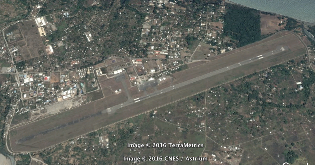
2.2.1 Solomon Islands Honiara International Airport
The airport is adequate for the current traffic volumes. There are no issues with the operational aspects of the airport. The only bottlenecks tend to occur at the security checkpoints. There have been recent upgrades to runway and apron surfaces and the addition of landing lights.
|
Airport Location and Contact |
|
|
Country |
|
|
Province or District |
Guadalcanal |
|
Nearest Town or City |
Honiara 8 km |
|
Airport’s Complete Name |
Honiara International airport |
|
Latitude |
|
|
Longitude |
160.0548
|
|
Elevation (ft and m) |
28 ft. / 9 m |
|
IATA Code |
HIR |
|
ICAO Code |
AGGH |
|
Managing Company or Airport Authority |
Civil Aviation Authority Of Solomon Islands |
|
Management Contact Person |
George Satu |
|
Open From (hours) |
00.00 |
|
Open To (hours) |
24.00 |
Airport Picture
Description and Contacts of Key Companies
Civil Aviation Authority Of Solomon Islands (CAASI) runs airport management, including responsibility for security. Ground handling duties are contracted to 3 companies; Solomon Airlines, Solomon Islands Terminal Services and Pacific Air Express.
For more information on government agency and airport company contact information, please see the following links:
4.2.5 Solomon Islands Airport Company Contact List
Information on some aviation service providers can be found at: http://www.azfreight.com/
Passenger and Cargo Performance Indicator
The airport operates at a satisfactory level for current demand. Peak periods are June July August when monthly traffic numbers increase by 30% (400flights/month). At this peak period the airport is operating to around 75% capacity.
|
Performance for 2014/15 |
|||
|
Per Year |
Per Month |
Per Day/ |
|
|
Total Aircraft Movements (2014) |
3,600 |
300 |
10 |
|
Total Passengers (2015) |
250,000 |
18,000 |
600 |
|
Total Capacity of the Airport (MT) |
1,440 |
120 |
4 |
|
Current Activity of the Airport (MT) |
500 |
40 |
2 |
|
Current use by Humanitarian Flights (UNHAS) |
NIL |
NIL |
NIL |
Cargo capacity is only being utilized at less than 50% with current facilities. There is no immediate plans to increase capacity or improve infrastructure at the airport.
Runways
Runway is in good condition there are no immediate plans to make any changes or improvements. There are no current issues with the runway.
|
Runway #1 |
|
|
Runway Dimensions |
2,200m x 45m |
|
Orientation |
06 24 (613 891.9mE 8,956874mN) |
|
Surface |
Asphalt |
Helicopter Pad(s)
There are no issues with current helicopter landing are. It is asphalt and in good condition.
|
Helipad #1 |
|
|
Present |
Yes |
|
Largest Helicopter that can Land |
Any |
|
Width and Length (m) |
50m x 50m |
|
Surface |
Asphalt |
Airport Infrastructure Details
The airfield has had regular maintenance following an upgrade of facilities that was funded by a Japanese aid program initiated in 2004. This resulted in upgrades to landing lights, runway and apron surfaces and the terminal building. There are on-going development plans contingent on the availability of funding.
|
Customs |
Yes |
JET A-1 fuel |
Yes |
|
Immigration |
Yes |
AVGAS 100 |
Yes |
|
Terminal Building |
Yes |
Single Point Refuelling |
Yes |
|
Passenger Terminal |
Yes |
Air Starter Units |
Yes |
|
Cargo terminal |
Yes |
Ground Power (mobile) |
Yes |
|
Pax Transport to Airfield |
Yes |
Ground Handling Services |
Yes |
|
Control Tower |
Yes |
Latrine Servicing |
Yes |
|
Weather Facilities |
Yes |
Fire Fighting Category (ICAO) |
Yes |
|
Catering Services |
Yes |
De-icing Equipment |
Yes |
|
Base Operating Room |
Yes |
Parking Ramp Lighting |
Yes |
|
Airport Radar |
No |
Approach & Runway Lights |
Yes |
|
NDB |
Yes |
VOR |
Yes |
|
ILS |
Yes |
Airport Operating Details
|
Operating Details |
|||
|
Maximum Sized Aircraft that can be Offloaded on Bulk Cargo |
B767 or A330 (Commercial) C7 lodestar (Military) |
||
|
Maximum Sized Aircraft that can be Offloaded on Pallet |
B767 or A330 (Commercial) C7 lodestar (Military) |
||
|
Total Aircraft Parking Area (m²) |
20,000m2 |
||
|
Storage Area (m3 and MT) |
No storage |
||
|
Handling Equipment |
|||
|
Elevators / Hi Loaders |
Yes |
Max Capacity (MT) |
3 ton |
|
Max Height (m) |
10 |
||
|
Loading Ramps |
Yes |
||
|
Other Comments |
1 x 2 ton forklift |
||
Customs Guidance
Once cargo has been checked by customs it is transported to one of 5 airfreight operators (Solomon Airlines, Pacific Air Express, Pacific Air Cargo, TNT and DHL). The cargo is stored in the bonded warehouse, pending clearance.
If paperwork is in order then goods should be cleared through customs within one to two days maximum. Usually same day clearance. Customs is on hand for all international arrivals and departures.
Organisations are able to clear their own shipments provided they can fill in the C15 template and submit the necessary documents to customs.
The main clearing agents at the airport are DHL, IT and Pacific Air Cargo
Language English, Pidgin.
For more information on customs in Solomon Islands please see the following link: 1.3 Solomon Islands Customs Information
Storage Facilities
Solomon Airlines' cargo terminal is located adjacent to the international passenger terminal at Honiara International Airport. It has a cargo handling area of approximately 390m². It has a bonded warehouse of 65 m².
There are no large areas of covered storage available at the Honiara airport. During disaster responses that involves the receipt of international relief cargo in large quantities, agencies would have to collect their cargo as soon as it was cleared if they needed it to be stored undercover.
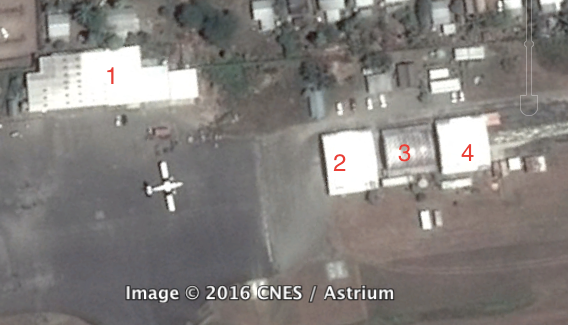
1. International Terminal 2, 3 & 4. Domestic terminal and offices
Airfield Cost
Navigation Charges
All charges are for international flights. All flights and aircraft weight classes are charged at the rate shown below.
All the charges below may be waived for humanitarian flights at the Director of CAASI’s discretion.
|
Charges |
Aircraft Weight - MTOW (kg) |
||
|
0 - 7,000 |
7,001 - 136,000 |
136,001 and over |
|
|
Navigation (per journey) USD - $ (Payable to Air Services Australia Ltd) |
225.00 |
||
|
Landing USD - $ |
1,042.00 |
||
|
Night Landing USD - $ |
15.00 |
||
|
Night Take-Off USD - $ |
|
15.00 |
|
|
Parking |
|
8.00/day |
|
|
Handling Charges |
|
Nil |
|
Fuel Services Charges
There are no charges for fuel services.
|
Price per Litre USD - $ |
|
|
Jet A-1 |
Nil |
|
Avgas |
Nil |
Cargo Terminal Charges
There are 3 cargo-handling companies at the airport. There standard charges applied by all are shown below
|
Import Charges |
||
|
Type of Charge |
Rate USD - $ per kg |
Comments |
|
Handling Charge |
1 kg – 100 kg Over 100 kg total |
$13 for total load amount 0.13c /kg each kg over the 100kg |
|
Break Bulk Fee |
Same as above |
|
|
Diplomatic Mail |
Same as above |
|
|
Strong Room – per consignment |
None |
|
|
Cold Storage Fee |
None |
|
|
Delivery Outside Normal Working Hours |
None |
|
|
Preparation of substitute AOA – Invoice – Receipt |
N/c |
|
|
Storage per Day |
1 – 50 kg $4.00/day 50 –100 kg $7.00/day Over 100 kg $13.00/day |
3 days grace period |
|
Export Charges (USD -$) |
||
|
Handling Charges – Un-palletized Cargo |
1 kg – 100 kg Over 100 kg total |
$13 for total load amount 0.13c /kg each kg over the 100kg |
|
International Air Waybill |
20.00 |
|
|
Local Air Waybill |
20.00 |
|
|
Air Way Bill Amendment - Cancellation |
N/c |
|
|
Air Way Bill Documentation |
N/c |
|
|
Diplomatic Mail |
13.00 |
|
|
Storage Charges per Day |
N/c |
|
Air-bridge Charges
There are no charges for the use of air bridges.
Further information on charges applied at Honiara International Airport, please see the following document:
Solomon Islands Honiara International Airport Additional Information
Note: The information provided in the attached documents, which has been taken from the old DLCA, does not match the structure of the new LCA and is therefore provided separately.
Security
Security Level: Good
Security is employed and managed by CAASI. Security Level: Good
The security at the Honiara Airport is of international standards and includes scanning of hand luggage and personel.
Companies Available
4.5 Solomon Islands Airport Company Contact List
Information on some aviation service providers can be found at:
2.2.2 Solomon Islands Munda National Airport
Airport Overview
Airport and facilities are in fair condition. Runway is in good condition. Although there are no scheduled international flights Munda can accommodate international flights (usually charter) if required, including C130’s. With prior arrangement CAASI will organise customs and quarantine officials to be on hand. There are planned upgrades to bring infrastructure to a standard necessary for Munda Airport runway to be certified by the Civil Aviation Authority of Solomon Islands as an 'emergency alternate status' runway. Civil works include the installation of airfield ground lighting and navigation aids, perimeter security fencing, an airport rescue and firefighting facility and two fire trucks. Project completion is expected in May 2017.
The total flight movement in 2015 was 2,500 flights and 40,000 passengers
|
Airport Location and Contact |
|
|
Country |
Solomon Islands |
|
Province or District |
Western Province |
|
Nearest Town or City |
Munda Adjacent |
|
Airport’s Complete Name |
Munda |
|
Latitude |
-8.327778 |
|
Longitude |
157.2631 |
|
Elevation (ft and m) |
10 ft. 3 m |
|
IATA Code |
MUA |
|
ICAO Code |
AGGM |
|
Managing Company or Airport Authority |
Air Traffic Services (Contracted by CAASI) |
|
Management Contact Person |
George Ngumi (Air Traffic Services Ltd) |
|
NGO and/or UN Presence at Airport? |
No |
Runway(s)
|
Runway #1 |
|
|
Runway Dimensions |
1400m x 30 m |
|
Runway Orientation |
07/25 |
|
Runway Surface |
Asphalt |
|
Runway Condition |
Good |
Airport Infrastructure Details
|
Infrastructure |
|||
|
Passenger / Cargo Security Screening |
No |
Runway Lighting |
No |
|
Refueling Capacity |
No |
Ground Handling Services |
No |
|
Air Traffic Control |
Yes |
Fire Fighting Equipment |
No |
|
Weather Information |
Yes |
Aircraft Parking Space |
Yes Max 2 (C130) |
|
Navigation Aids |
No |
Perimeter Fencing |
No |
|
Windsock |
Yes |
|
|
Fuel Services Charges
There are no fuel services available.
|
Price per Litre USD - $ |
|
|
Jet A-1 |
N/available |
|
Avgas |
N/available |
Royalties / Non Objection Fees (NOFs)
There are no Royalties of NOF’s.
There are no landing fees for domestic flights for International flights the same fees that apply at Honiara Airport apply at Munda.
Security
There is no security at Munda Airport.
There are 33 smaller unpaved airports/airfields in the Solomon Islands, some of which are not fully operational. Many of these runways are still operational after heavy rain as the corral rock provides a solid landing base.
The airports of Gizo, Munda, Seghe, Kirakira, Santa Cruz and Auki are able to accomodate Dash 8’s. The remaining airports if operational are able to receive Twin Otters. There is no night flying equipment and no refueling services at the regional airports.
Munda airport on New Georgia Island can accommodate international (usually charter) flights, including C130’s. The total flight movement in 2009 was 2002 flights.
2.2.3 Solomon Islands Other National Airports
There are 39 smaller unpaved airports/airfields in the Solomon Islands, some of which are not fully operational. Many of these runways are still operational after heavy rain as the corral rock provides a solid landing base.
The airports of Gizo, Munda, Seghe, Kirakira, Santa Cruz and Auki are able to accomodate Dash 8’s. The remaining airports if operational are able to receive Twin Otters. There is no night flying equipment and no refueling services at the regional airports.
2.2.3 Solomon Islands Afutara (Malaita Island) Airport
2.2.4 Solomon Islands Anuha Airport (Nggela Islands) Airport
2.2.5 Solomon Islands Ulawa Airport
2.2.6 Solomon Islands Atoifi Airport
2.2.7 Solomon Islands Auki Airport
2.2.8 Solomon Islands Avu Avu Airport
2.2.9 Solomon Islands Balalae (Shortland Island) Airport
2.2.10 Solomon Islands Barakoma Airport
2.2.11 Solomon Islands Barora Airport
2.2.12 Solomon Islands Batuna Airport
2.2.13 Solomon Islands Bellona/Anua Airport
2.2.14 Solomon Islands Choiseul Bay Airport
2.2.15 Solomon Islands Fera Airport
2.2.16 Solomon Islands Gatokae Airport
2.2.17 Solomon Islands Geva Airport
2.2.18 Solomon Islands Nusatupe Airport
2.2.19 Solomon Islands Kaghau Airport
2.2.20 Solomon Islands Kirakira Airport
2.2.21 Solomon Islands Kukudu Airport
2.2.22 Solomon Islands Kwai Harbour Airport
2.2.23 Solomon Islands Marau Airport
2.2.24 Solomon Islands Parasi Airport
2.2.25 Solomon Islands Mbambanakira Airport
2.2.26 Solomon Islands Mono Airport
2.2.26 Solomon Islands Mono Airport
2.2.27 Solomon Islands Onepusu Airport
2.2.28 Solomon Islands Ontong Java Airport
2.2.29 Solomon Islands Parasi Airport
2.2.30 Solomon Islands Ramata Airport
2.2.31 Salomon Islands Rennell/Tingoa Airport
2.2.32 Solomon Islands Ringgi Cove Airport
2.2.33 Solomon Islands Santa Ana Airport
2.2.34 Solomon Islands Santa Cruz Airport
2.2.35 Solomon Islands Savo Airport
2.2.36 Solomon Islands Seghe Airport
2.2.37 Solomon Islands Suavanao Airport
2.2.38 Solomon Islands Tarapaina Airport
2.2.39 Solomon Islands Tulagi Island Airport
2.2.40 Solomon Islands Viru Airport
2.2.41 Solomon Islands Yandina Airport
2.2.3 Solomon Islands Afutara (Malaita Island) Airport
Airport Overview
|
Airport Location and Contact |
|
|---|---|
|
Country |
Solomon Islands |
|
Province or District |
Malaita |
|
Nearest Town or City |
|
|
Airport’s Complete Name |
Afutara Airport |
|
Latitude |
-9.64571 |
|
Longitude |
160.156189 |
|
Elevation (ft and m) |
|
|
IATA Code |
AFT |
|
ICAO Code |
AGAF |
|
Managing Company or Airport Authority |
|
|
Management Contact Person |
|
|
NGO and/or UN Presence at Airport? |
|
This airport has a scheduled service on commercial airlines.
2.2.4 Solomon Islands Anuha Airport (Nggela Islands) Airport
Airport Overview
|
Airport Location and Contact |
|
|---|---|
|
Country |
Solomon Islands |
|
Province or District |
Central |
|
Nearest Town or City |
|
|
Airport’s Complete Name |
Anuha Airport |
|
Latitude |
-9.64571 |
|
Longitude |
160.156189 |
|
Elevation (ft and m) |
|
|
IATA Code |
ANH |
2.2.5 Solomon Islands Ulawa Airport
Airport Overview
|
Airport Location and Contact |
|
|---|---|
|
Country |
Solomon Islands |
|
Province or District |
Makira-Ulawa |
|
Nearest Town or City |
|
|
Airport’s Complete Name |
Ulawa Airport (Arona Airport) |
|
Latitude |
-9.86083 |
|
Longitude |
161.98 |
|
Elevation (ft and m) |
|
|
IATA Code |
RNA |
|
ICAO Code |
AGAR |
This airport has a scheduled service on commercial airlines.
2.2.6 Solomon Islands Atoifi Airport
Airport Overview
|
Airport Location and Contact |
|
|---|---|
|
Country |
Solomon Islands |
|
Province or District |
Malaita |
|
Nearest Town or City |
|
|
Airport’s Complete Name |
Uru Harbour Airport (Atoifi Airport) |
|
Latitude |
-8.873333 |
|
Longitude |
161.011389 |
|
Elevation (ft and m) |
|
|
IATA Code |
ATD |
|
ICAO Code |
AGAT |
The airport has a scheduled service on commercial airlines.
2.2.7 Solomon Islands Auki Airport
Airport Overview
|
Airport Location and Contact |
|
|---|---|
|
Country |
Solomon Islands |
|
Province or District |
Malaita |
|
Nearest Town or City |
|
|
Airport’s Complete Name |
Auki Gwaunaru'u Airport |
|
Latitude |
-8.697778 |
|
Longitude |
160.680833 |
|
Elevation (ft and m) |
|
|
IATA Code |
AKS |
|
ICAO Code |
AGGA |
The airport has scheduled service on commercial airlines and is able to accommodate Dash 8s.
2.2.8 Solomon Islands Avu Avu Airport
Airport Overview
|
Airport Location and Contact |
|
|---|---|
|
Country |
Solomon Islands |
|
Province or District |
Guadalcanal |
|
Nearest Town or City |
|
|
Airport’s Complete Name |
Avu Avu Airport |
|
Latitude |
-9.8683333 |
|
Longitude |
160.4105556 |
|
Elevation (ft and m) |
|
|
IATA Code |
AVU |
|
ICAO Code |
AGGJ |
The airport has scheduled service on commercial airlines.
2.2.9 Solomon Islands Balalae (Shortland Island) Airport
Airport Overview
|
Airport Location and Contact |
|
|---|---|
|
Country |
Solomon Islands |
|
Province or District |
Western |
|
Nearest Town or City |
|
|
Airport’s Complete Name |
Balalae Airport |
|
Latitude |
-6.9925 |
|
Longitude |
155.888333 |
|
Elevation (ft and m) |
|
|
IATA Code |
BAS |
|
ICAO Code |
AGGE |
The airport has scheduled service on commercial airlines.
2.2.10 Solomon Islands Barakoma Airport
Airport Overview
|
Airport Location and Contact |
|
|---|---|
|
Country |
Solomon Islands |
|
Province or District |
Western |
|
Nearest Town or City |
Barakoma, Vella Lavella Island |
|
Airport’s Complete Name |
Barakoma Airport |
|
Latitude |
-7.913 |
|
Longitude |
156.706 |
|
Elevation (ft and m) |
|
|
IATA Code |
VEV |
|
ICAO Code |
AGBA |
2.2.11 Solomon Islands Barora Airport
Airport Overview
|
Airport Location and Contact |
|
|---|---|
|
Country |
Solomon Islands |
|
Province or District |
Western |
|
Nearest Town or City |
Barora, New Georgia Island |
|
Airport’s Complete Name |
Barora Airport |
| Latitude | -7.6 |
| Longitude | 58.4 |
|
Elevation (ft and m) |
|
|
IATA Code |
RRI |
|
ICAO Code |
|
2.2.12 Solomon Islands Batuna Airport
Airport Overview
|
Airport Location and Contact |
|
|---|---|
|
Country |
Solomon Islands |
|
Province or District |
Western |
|
Nearest Town or City with Distance from Airport |
Batuna, Vangunu Island |
|
Airport’s Complete Name |
Batuna Airport |
|
Latitude |
-8.5620278 |
|
Longitude |
158.1193056 |
|
Elevation (ft and m) |
|
|
IATA Code |
BPF |
|
ICAO Code |
AGBT |
2.2.13 Solomon Islands Bellona/Anua Airport
Airport Overview
|
Airport Location and Contact |
|
|---|---|
|
Country |
Solomon Islands |
|
Province or District |
Rennell and Bellona |
|
Nearest Town or City |
Anua, Bellona Island |
|
Airport’s Complete Name |
Bellona/Anua Airport |
|
Latitude |
-11.301667 |
|
Longitude |
159.798056 |
|
Elevation (ft and m) |
|
|
IATA Code |
BNY |
|
ICAO Code |
AGGB |
The airport has scheduled service on commercial airlines.
2.2.14 Solomon Islands Choiseul Bay Airport
Airport Overview
|
Airport Location and Contact |
|
|---|---|
|
Country |
Solomon Islands |
|
Province or District |
Choiseul |
|
Nearest Town or City |
Choiseul Bay, Taro Island |
|
Airport’s Complete Name |
Choiseul Bay Airport |
|
Latitude |
-6.711944 |
|
Longitude |
156.396111 |
|
Elevation (ft and m) |
|
|
IATA Code |
CHY |
|
ICAO Code |
AGGC |
The airport has scheduled service on commercial airlines.
2.2.15 Solomon Islands Fera Airport
Airport Overview
|
Airport Location and Contact |
|
|---|---|
|
Country |
Solomon Islands |
|
Province or District |
Isabel |
|
Nearest Town or City |
Maringe, Fera Island (near Santa Isabel Island) |
|
Airport’s Complete Name |
Fera/Maringe Airport |
|
Latitude |
-8.107222 |
|
Longitude |
159.5775 |
|
Elevation (ft and m) |
|
|
IATA Code |
FRE |
|
ICAO Code |
AGGF |
The airport has scheduled service on commercial airlines.
2.2.16 Solomon Islands Gatokae Airport
Airport Overview
|
Airport Location and Contact |
|
|---|---|
|
Country |
Solomon Islands |
|
Province or District |
Western |
|
Nearest Town or City |
Gatokae (Nggatokae Island), New Georgia Islands |
|
Airport’s Complete Name |
Gatokae Aerodrome (Gatokae Airport) |
|
Latitude |
-8.739167 |
|
Longitude |
158.203056 |
|
Elevation (ft and m) |
|
|
IATA Code |
GTA |
|
ICAO Code |
AGOK |
The airport has scheduled service on commercial airlines.
2.2.17 Solomon Islands Geva Airport
Airport Overview
|
Airport Location and Contact |
|
|---|---|
|
Country |
Solomon Islands |
|
Province or District |
Western |
|
Nearest Town or City |
Geva, Vella Lavella Island |
|
Airport’s Complete Name |
Geva Airport |
|
Latitude |
-7.57583 |
|
Longitude |
156.5970001 |
|
Elevation (ft and m) |
|
|
IATA Code |
GEF |
|
ICAO Code |
AGEV |
2.2.18 Solomon Islands Nusatupe Airport
Airport Overview
|
Airport Location and Contact |
|
|---|---|
|
Country |
Solomon Islands |
|
Province or District |
Western |
|
Nearest Town or City |
Gizo, Ghizo Island |
|
Airport’s Complete Name |
Nusatupe Airport (Gizo Airport) |
|
Latitude |
-8.098611 |
|
Longitude |
156.864167 |
|
Elevation (ft and m) |
|
|
IATA Code |
GZO |
|
ICAO Code |
AGGN |
The airport has scheduled service on commercial airlines. The airport is able to accommodate Dash 8s.
2.2.19 Solomon Islands Kaghau Airport
Airport Overview
|
Airport Location and Contact |
|
|---|---|
|
Country |
Solomon Islands |
|
Province or District |
Choiseul |
|
Nearest Town or City |
Kaghau Island |
|
Airport’s Complete Name |
Kaghau Airport |
|
Latitude |
-7.332778 |
|
Longitude |
157.586944 |
|
Elevation (ft and m) |
|
|
IATA Code |
KGE |
|
ICAO Code |
AGKG |
The airport has scheduled service on commercial airlines.
2.2.20 Solomon Islands Kirakira Airport
Airport Overview
|
Airport Location and Contact |
|
|---|---|
|
Country |
Solomon Islands |
|
Province or District |
Makira-Ulawa |
|
Nearest Town or City |
Kirakira, Makira Island |
|
Airport’s Complete Name |
Kirakira Airport (Ngorangora Airstrip) |
|
Latitude |
-10.449444 |
|
Longitude |
161.898333 |
|
Elevation (ft and m) |
|
|
IATA Code |
IRA |
|
ICAO Code |
AGGK |
The airport has scheduled service on commercial airlines. The airport is able to accomodate Dash 8s.
2.2.21 Solomon Islands Kukudu Airport
Airport Overview
|
Airport Location and Contact |
|
|---|---|
|
Country |
Solomon Islands |
|
Province or District |
Western |
|
Nearest Town or City with Distance from Airport |
Kukudu (Kukundu), Kolombangara |
|
Airport’s Complete Name |
Kukudu Airport |
|
Latitude |
-8.0262 |
|
Longitude |
156.94783 |
|
Elevation (ft and m) |
|
|
IATA Code |
KUE |
|
ICAO Code |
AGKU |
2.2.22 Solomon Islands Kwai Harbour Airport
Airport Overview
|
Airport Location and Contact |
|
|---|---|
|
Country |
Solomon Islands |
|
Province or District |
Malaita |
|
Nearest Town or City |
Kwai Harbour |
|
Airport’s Complete Name |
Kwai Harbour Airport |
|
Latitude |
-8.869807 |
|
Longitude |
161.003909 |
|
Elevation (ft and m) |
112 ft |
|
IATA Code |
KWR |
|
ICAO Code |
|
2.2.23 Solomon Islands Marau Airport
Airport Overview
|
Airport Location and Contact |
|
|---|---|
|
Country |
Solomon Islands |
|
Province or District |
Guadalcanal |
|
Nearest Town or City |
Marau, Guadalcanal Island |
|
Airport’s Complete Name |
Marau Airport |
|
Latitude |
-9.861667 |
|
Longitude |
160.825 |
|
Elevation (ft and m) |
|
|
IATA Code |
RUS |
|
ICAO Code |
AGGU |
The airport has scheduled service on commercial airlines.
2.2.24 Solomon Islands Parasi Airport
Airport Overview
|
Airport Location and Contact |
|
|---|---|
|
Country |
Solomon Islands |
|
Province or District |
Guadalcanal |
|
Nearest Town or City |
Parasi, Marau Sound Island |
|
Airport’s Complete Name |
Marau Sound Airport (Parasi Airport) |
|
Latitude |
-9.6416702 |
|
Longitude |
161.4250031 |
|
Elevation (ft and m) |
|
|
IATA Code |
PRS |
|
ICAO Code |
AGGP |
2.2.25 Solomon Islands Mbambanakira Airport
Airport Overview
|
Airport Location and Contact |
|
|---|---|
|
Country |
Solomon Islands |
|
Province or District |
Guadalcanal |
|
Nearest Town or City |
Mbambanakira, Guadalcanal Island |
|
Airport’s Complete Name |
Mbambanakira Airport (Babanakira Airfield) |
|
Latitude |
-9.7475 |
|
Longitude |
159.838889 |
|
Elevation (ft and m) |
|
|
IATA Code |
MBU |
|
ICAO Code |
AGGD |
The airport has scheduled service on commercial airlines.
2.2.26 Solomon Islands Mono Airport
Airport Overview
|
Airport Location and Contact |
|
|---|---|
|
Country |
Solomon Islands |
|
Province or District |
Western |
|
Nearest Town or City |
Mono Island, Treasury Islands |
|
Airport’s Complete Name |
Mono Airport |
|
Latitude |
-7.416111 |
|
Longitude |
155.565278 |
|
Elevation (ft and m) |
|
|
IATA Code |
MNY |
|
ICAO Code |
AGGO |
The airport has scheduled service on commercial airlines.
2.2.27 Solomon Islands Onepusu Airport
Airport Overview
|
Airport Location and Contact |
|
|---|---|
|
Country |
Solomon Islands |
|
Province or District |
Malaita |
|
Nearest Town or City |
Onepusu |
|
Airport’s Complete Name |
|
|
Elevation (ft and m) |
|
|
IATA Code |
ONE |
|
ICAO Code |
|
2.2.28 Solomon Islands Ontong Java Airport
Airport Overview
|
Airport Location and Contact |
|
|---|---|
|
Country |
Solomon Islands |
|
Province or District |
Malaita |
|
Nearest Town or City |
Ontong Java |
|
Airport’s Complete Name |
Ontong Java Airport |
|
Latitude |
-5.515 |
|
Longitude |
159.5277778 |
|
Elevation (ft and m) |
|
|
IATA Code |
|
|
ICAO Code |
AGGQ |
2.2.29 Solomon Islands Parasi Airport
Airport Overview
|
Airport Location and Contact |
|
|---|---|
|
Country |
Solomon Islands |
|
Province or District |
Malaita |
|
Nearest Town or City |
Parasi |
|
Airport’s Complete Name |
Parasi Airport |
|
Latitude |
|
|
Longitude |
|
|
Elevation (ft and m) |
|
|
IATA Code |
PRS |
|
ICAO Code |
|
2.2.30 Solomon Islands Ramata Airport
Airport Overview
|
Airport Location and Contact |
|
|---|---|
|
Country |
Solomon Islands |
|
Province or District |
Western |
|
Nearest Town or City |
Ramata Airport (Ramata Island) |
|
Airport’s Complete Name |
Ramata Airport (Ramata Island Airstrip) |
|
Latitude |
-8.168056 |
|
Longitude |
157.6425 |
|
Elevation (ft and m) |
|
|
IATA Code |
RBV |
|
ICAO Code |
AGRM |
The airport has scheduled service on commercial airlines.
2.2.31 Salomon Islands Rennell/Tingoa Airport
Airport Overview
|
Airport Location and Contact |
|
|---|---|
|
Country |
Solomon Islands |
|
Province or District |
Rennell and Bellona |
|
Nearest Town or City |
Tingoa, Rennell Island |
|
Airport’s Complete Name |
|
|
Latitude |
-11.55 |
|
Longitude |
160.062778 |
|
Elevation (ft and m) |
|
|
IATA Code |
RNL |
|
ICAO Code |
AGGR |
The airport has scheduled service on commercial airlines.
2.2.32 Solomon Islands Ringgi Cove Airport
Airport Overview
|
Airport Location and Contact |
|
|---|---|
|
Country |
Solomon Islands |
|
Province or District |
Western |
|
Nearest Town or City |
Ringgi Cove, Kolombangara |
|
Airport’s Complete Name |
Ringgi Cove Airport (Vila Airport) |
|
Latitude |
-8.12639 |
|
Longitude |
157.14301 |
|
Elevation (ft and m) |
|
|
IATA Code |
RIN |
|
ICAO Code |
AGRC |
2.2.33 Solomon Islands Santa Ana Airport
Airport Overview
|
Airport Location and Contact |
|
|---|---|
|
Country |
Solomon Islands |
|
Province or District |
Makira-Ulawa |
|
Nearest Town or City |
Santa Ana Island (Owaraha) |
|
Airport’s Complete Name |
Santa Ana Airport |
|
Latitude |
-10.848056 |
|
Longitude |
162.454167 |
|
Elevation (ft and m) |
|
|
IATA Code |
NNB |
|
ICAO Code |
AGGT |
The airport has scheduled service on commercial airlines.
2.2.34 Solomon Islands Santa Cruz Airport
Airport Overview
|
Airport Location and Contact |
|
|---|---|
|
Country |
Solomon Islands |
|
Province or District |
Temotu |
|
Nearest Town or City |
Santa Cruz Islands |
|
Airport’s Complete Name |
|
|
Latitude |
-10.719722 |
|
Longitude |
165.797778 |
|
Elevation (ft and m) |
|
|
IATA Code |
SCZ |
|
ICAO Code |
AGGL |
The airport has scheduled service on commercial airlines. The airport can accommodate Dash 8s.
2.2.35 Solomon Islands Savo Airport
Airport Overview
|
Airport Location and Contact |
|
|---|---|
|
Country |
Solomon Islands |
|
Province or District |
Central |
|
Nearest Town or City |
Savo Island |
|
Airport’s Complete Name |
|
| Latitude | -9.15975 |
| Longitude | 159.818 |
|
Elevation (ft and m) |
|
|
IATA Code |
SVY |
|
ICAO Code |
|
2.2.36 Solomon Islands Seghe Airport
Airport Overview
|
Airport Location and Contact |
|
|---|---|
|
Country |
Solomon Islands |
|
Province or District |
Western |
|
Nearest Town or City |
Seghe, New Georgia Island |
|
Airport’s Complete Name |
Seghe Airport |
|
Latitude |
-8.578 |
|
Longitude |
157.875 |
|
Elevation (ft and m) |
|
|
IATA Code |
EGM |
|
ICAO Code |
AGGS |
The airport has scheduled service on commercial airlines. The airport can accommodate Dash 8s.
2.2.37 Solomon Islands Suavanao Airport
Airport Overview
|
Airport Location and Contact |
|
|---|---|
|
Country |
Solomon Islands |
|
Province or District |
Isabel |
|
Nearest Town or City |
Suavanao, Santa Isabel Island |
|
Airport’s Complete Name |
|
|
Latitude |
-7.585833 |
|
Longitude |
158.731389 |
|
Elevation (ft and m) |
|
|
IATA Code |
VAO |
|
ICAO Code |
AGGV |
The airport has scheduled service on commercial airlines.
2.2.38 Solomon Islands Tarapaina Airport
Airport Overview
|
Airport Location and Contact |
|
|---|---|
|
Country |
Solomon Islands |
|
Province or District |
Malaita |
|
Nearest Town or City |
Tarapaina |
|
Airport’s Complete Name |
|
| Latitude | -9.4333333 |
| Longitude | 161.3833333 |
|
Elevation (ft and m) |
|
|
IATA Code |
TAA |
|
ICAO Code |
|
2.2.39 Solomon Islands Tulagi Island Airport
Airport Overview
|
Airport Location and Contact |
|
|---|---|
|
Country |
Solomon Islands |
|
Province or District |
Central |
|
Nearest Town or City |
Tulagi Island (Tulaghi) |
|
Airport’s Complete Name |
|
|
Latitude |
-9.1 |
|
Longitude |
160.15 |
|
Elevation (ft and m) |
|
|
IATA Code |
TLG |
|
ICAO Code |
AGTI |
2.2.40 Solomon Islands Viru Airport
Airport Overview
|
Airport Location and Contact |
|
|---|---|
|
Country |
Solomon Islands |
|
Province or District |
Western |
|
Nearest Town or City |
Viru, New Georgia Island |
|
Airport’s Complete Name |
Viru Airport (Viru Harbour Airstrip) |
|
Latitude |
-8.466667 |
|
Longitude |
157.766667 |
|
Elevation (ft and m) |
130 ft/40 m |
|
IATA Code |
VIU |
|
ICAO Code |
|
2.2.41 Solomon Islands Yandina Airport
Airport Overview
|
Airport Location and Contact |
|
|---|---|
|
Country |
Solomon Islands |
|
Province or District |
Central Province |
|
Nearest Town or City |
Yandina, Mbanika Island, Russell Islands |
|
Airport’s Complete Name |
|
|
Latitude |
-9.092778 |
|
Longitude |
159.218889 |
|
Elevation (ft and m) |
|
|
IATA Code |
XYA |
|
ICAO Code |
AGGY |
The airport has scheduled service on commercial airlines.