2.3 Panama Road Network
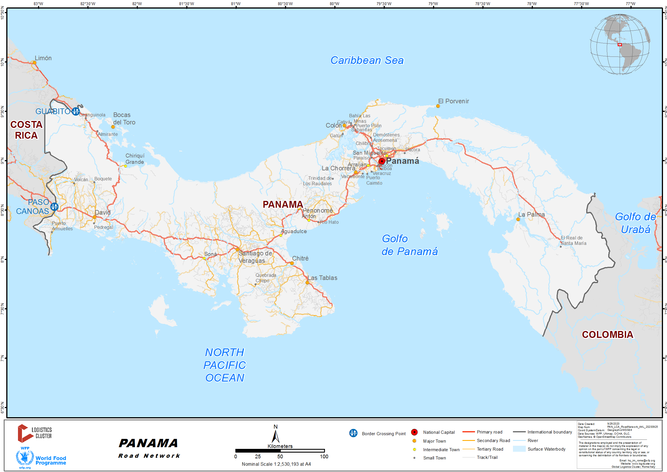
The Panamanian Government, through the Ministry of Public Works, created a five-year-Plan for 2019-2024, which considers main investment projects to improve Panama’s road network. The five-year plan includes the Get-to-Work project, as well as inspection, construction, and maintenance projects on a nationwide level.
The Get-to-Work project consists in the rehabilitation and maintenance of streets, roads, as well as production routes. Priority is given to the contracting of national companies; increasing the participation of local labor and companies and hence the reactivation of the internal economy.
Currently the road network displays challenges such as weight restrictions through the Bridge of the Americas, where cargo movements are deviated towards the Centennial Bridge, as well as lane reversals on the Pan-American Highway during morning and afternoon hours from Monday to Friday, to support the mobilization of the population that resides at the west side of the Panama Canal.
For more information on government contact details, please see the following link: 4.1 Government Contact List.
Distance Matrix
|
Distance from Panama City (Capital) to Major Towns in the country (km) |
|||||||||
|---|---|---|---|---|---|---|---|---|---|
|
Panama |
Colon |
Yaviza |
Chorrera |
Penonome |
Las Tablas |
Chitre |
Santiago |
David |
|
|
Panama |
|
74.5 |
282.4 |
38.8 |
155.8 |
283.9 |
253.3 |
251.8 |
445.3 |
|
Colon |
73.2 |
|
343 |
89.5 |
206.5 |
334.6 |
304 |
302.4 |
496 |
|
Yaviza |
282.4 |
342.2 |
|
320.4 |
437.4 |
565.6 |
534.9 |
533.4 |
727 |
|
La Chorrera |
48.8 |
89.2 |
320. |
|
121.1 |
249.3 |
218.6 |
217.1 |
410.6 |
|
Penonome |
156 |
207.8 |
438.8 |
120.3 |
|
136.8 |
106.2 |
104.7 |
298.2 |
|
Las Tablas |
283.9 |
335.7 |
566.6 |
248.2 |
137.2 |
|
32.8 |
103.8 |
297.4 |
|
Chitre |
252.8 |
304.6 |
535.5 |
217.1 |
106.1 |
31.4 |
|
72.7 |
266.3 |
|
Santiago |
251.7 |
303.5 |
534.4 |
216 |
105 |
103.4 |
72.7 |
|
197.2 |
|
David |
444.3 |
496.1 |
727.1 |
408.6 |
297.6 |
296 |
265.4 |
196.4 |
|
Source: Information extracted on the 6 March, 2020 at 09:00 a.m., from Google Maps
Time Matrix
|
Travel time from Panama City (Capital) to Major Towns in the country (hr) |
|||||||||
|---|---|---|---|---|---|---|---|---|---|
|
Panama |
Colon |
Yaviza |
La Chorrera |
Penonome |
Las Tablas |
Chitre |
Santiago |
David |
|
|
Panama |
|
1 h 8 min |
4 h 13 min |
45 min |
2 h 27 min |
4 h 2 min |
3 h 30 min |
3 h 32 min |
5 h 53 min |
|
Colón |
1 h 7 min |
|
5 h 1 min |
1 h 15 min |
2 h 57 min |
4 h 33 min |
4 h 1 min |
4 h 3 min |
6 h 23 min |
|
Yaviza |
4 h 24 min |
5 h |
|
4 h 48 min |
6 h 34 min |
8 h 15 min |
7 h 39 min |
7 h 42 min |
10 h 7 min |
|
La Chorrera |
57 min |
1 h 24 min |
4 h 53 min |
|
1 h 50 min |
3 h 25 min |
2 h 54 min |
2 h 57 min |
5 h 18 min |
|
Penonome |
2 h 32 min |
2 h 55 min |
6 h 28 min |
1 h 57 min |
|
2 h 1 min |
1 h 29 min |
1 h 32 min |
3 h 52 min |
|
Las Tablas |
4 h 6 min |
4 h 32 min |
8 h 2 min |
3 h 35 min |
2 h 3 min |
|
36 min |
1 h 34 min |
3 h 55 min |
|
Chitre |
3 h 36 min |
4 h 1 min |
7 h 28 min |
3 h 4 min |
1 h 32 min |
33 min |
|
1 h 2 min |
3 h 23 min |
|
Santiago |
3 h 36 min |
4 h 1 min |
7 h 28 min |
3 h 4 min |
1 h 31 min |
1 h 31 min |
1 h 1 min |
|
2 h 31 min |
|
David |
5 h 59 min |
6 h 21 min |
9 h 54 min |
5 h 24 min |
3 h 55 min |
3 h 56 min |
3 h 25 min |
2 h 32 min |
|
Source: Information extracted on the 6 March, 2020 at 09:00 a.m., from Google Maps
Road Security
There hasn’t been any road safety problems, at least not for cargo transport.
Weighbridges and Axle Load Limits
Currently weight and dimensions are regulated by Law 10 of 1989, of the Republic of Panama.
|
Axle Load Limits |
LCA Country Panama |
Transit Country Costa Rica |
|---|---|---|
|
Truck with 2 Axles |
14 tons |
N/A |
|
Truck with 3 Axles |
21.9 tons |
N/A |
|
Truck with 4 Axles |
27.5 tons |
N/A |
|
Semi-trailer with 3 Axles |
25.5 tons |
N/A |
|
Semi-trailer with 4 Axles |
31.9 tons |
N/A |
|
Semi-trailer with 5 Axles |
37.5 tons |
N/A |
|
Semi-trailer with 6 Axles |
43.9 tons |
N/A |
|
Truck & Drawbar Trailer with 4 Axles |
30 tons |
N/A |
|
Truck & Drawbar Trailer with 5 Axles |
36.5 tons |
N/A |
|
Truck & Drawbar Trailer with 6 Axles |
44.4 tons |
N/A |
|
Truck & Drawbar Trailer with 7 Axles |
N/A |
N/A |
Class and Road Surface Class and Conditions
N/A
2.3.1 Panama Border Crossing with Costa Rica
Overview
The border crossings in general have an average performance, there are difficulties inasmuch for tourists, as for cargo transport. Each state institution manages their installations as per their capacities, there is no overall general administrator of the infrastructure.
In Paso Canoas, the access road from Costa Rica lacks parking spaces and the presence of street vendors causes long queues. In Guabito, there are limitations in the physical space available for the inspection of merchandise and vehicles at the entry and exit of the country. In addition, there are no areas for luggage inspection nor scanners.
Paso Canoas
|
Location and Border Crossing contact |
|
|---|---|
|
Name of the Border Crossing |
Panama: Paso Canoas Costa Rica: Paso Canoas |
|
Province or District |
Province of Chiriqui, District of Baru, Corregimiento of Progreso. |
|
Nearest Town or city with distance from the border crossing |
Corregimiento of Progreso, 12 km |
|
Latitude |
8.53402778 |
|
Longitude |
82.83833333 |
|
Administrative Authority / Agency |
National Customs Authority |
|
Contact |
Jaime Jeneth Quintero Santamaría Customs Administrator, Western Zone 775-4433 / 1982 |
|
Travel Times |
|
|---|---|
|
Closest International Airport |
Enrique Malek Int., Airport, 53 km Travel time by Truck: 2 hrs Travel time by Car: 1 hr |
|
Nearest Port |
Port Armuelles, 35 km Travel time by Truck: 2 hrs Travel time by car: 1 hr 20 min |
|
Nearest location with wholesale markets in operation, or with a significant manufacturing or production capacity. |
Paso Canoas, 100 mts Travel time by Truck: 5 min Travel time by Car: 1 min |
|
Other Information |
|
|
Work Hours |
|
|---|---|
|
Monday |
7:00 a.m. a 11:00 p.m. |
|
Tuesday |
7:00 a.m. a 11:00 p.m. |
|
Wednesday |
7:00 a.m. a 11:00 p.m. |
|
Thursday |
7:00 a.m. a 11:00 p.m. |
|
Friday |
7:00 a.m. a 11:00 p.m. |
|
Saturday |
7:00 a.m. a 11:00 p.m. |
|
Sunday |
7:00 a.m. a 11:00 p.m. |
|
National Holidays |
7:00 a.m. a 11:00 p.m. |
|
Seasonal Restrictions |
7:00 a.m. a 11:00 p.m. |
Daily Capacity
Inflow is constant, during holidays tourists entering/exiting increases, cargo in less quantities. Lanes are distributed in 6 lanes: 2 exit lanes for cargo and 1 for tourism; two (2) entry lanes for cargo and one (1) for tourism. Cargo volume entering surpasses 2,000 vehicles monthly, while cargo volume departing surpasses 1,200 vehicles monthly. As to tourism, such transcends to 700 vehicles a month during peak season, whereas their departure does not outstrip 500 vehicles a month.
Customs Clearance
The entity that regulates the establishment and compliance with of customs requirements is the National Customs Authority. General rates are placed by merchandise and bulks.
For customs clearance of merchandise destined for commerce the following is required:
- Merchandise Declaration Form (DM, in Spanish)
- Central American Single Declaration Form(DUCA, in Spanish)
- Non-Nationalized Goods Transfer Form (TI TT, in Spanish)
- And that established in article 321 of the Central American Uniform Customs Code and its Regulations (RECAUCA, in Spanish).
In case of urgent shipments (for humanitarian aid), the clearance procedure to be applied shall be that established in the Article 556 of the RECAUCA, and will be dispatched through simple and expedite procedures, in coordination with the competent authorities. Whenever relief shipments arrive consigned to entities of social interest, of charity, non-governmental organizations, associations and/or foundations of public interest, introduction of the merchandise will be authorized, as long as the bill of lading is endorsed to the government entity in charge of channeling the aid/help.
Restrictions apply in cases where goods require a special treatment or approval by an institution other than Customs, whenever the bill of lading is incomplete or whenever a delay in procedure is encountered by the customs assistant. For border crossing through Central America, the Single Declaration Form (DUCA) and its supporting documents are required: cargo manifest, waybill and invoices.
For more information on customs in Panamá, please see the following link: 1.3 Customs Information.
Relevant Additional Information
In addition to Customs procedures, whenever applicable, cargo and vehicles must also meet the requirements of other institutions, such as: the National Immigration Service, the Transportation Authority, the Judicial Investigative Directorate and the Health Ministry.
The requirements to pass vehicle control are the following:
- Copy of Passport or Citizenship I.D. Card
- Vehicle Title
- Vehicle Insurance
- If the vehicle is not yours, you must provide a Power of Attorney.
For more information on government contact details, please see the following link: 4.1 Government Contact List.
Guabito
|
Location and contact of border crossings |
|
|---|---|
|
Name of Border Crossing |
Recinto Guabito |
|
Province or District |
Bocas del Toro, Changuinola, Guabito. |
|
Nearest town or city with distance from the border crossing |
Changuinola, 12 km |
|
Latitude |
9.50000000 |
|
Longitude |
82.62000000 |
|
Administrative Authority / Agency |
Administration of the Northwestern Zone, Bocas del Toro. National Customs Authority |
|
Contact Person |
Aaron Chavez (Administrator of the Northwestern Zone) Administrator, Northwestern Zone 758-7746 / 7251 |
|
Travel Times |
|
|---|---|
|
Nearest Airport |
Jose Ezequiel Hall (located in Isla Colon), 70 km Travel time by truck: 3 Hours Travel time by carl: 3 Hours A ferry must be taken (Palanga) from Isla Colon to Almirante. |
|
Nearest Port |
Port of Almirante, 40 km Travel time by truck: 1 hour Travel time by car: 45 Min |
|
Nearest location with wholesale markets in operation, or with a significant manufacturing or production capacity. |
Packaging companies of the banana farms of CHIQUITA PANAMA, LLC (farms #53 and #41) and of the COOBANA Cooperative (Farm #80) |
|
Other information |
|
|
Office Hours |
|
|---|---|
|
Monday |
8:00 am to 6:00 pm |
|
Tuesday |
8:00 am to 6:00 pm |
|
Wednesday |
8:00 am to 6:00 pm |
|
Thursday |
8:00 am to 6:00 pm |
|
Friday |
8:00 am to 6:00 pm |
|
Saturday |
8:00 am to 6:00 pm |
|
Sunday |
8:00 am to 6:00 pm |
|
National Holidays |
8:00 am to 6:00 pm |
|
Seasonal restrictions |
Open at scheduled hours every day a week, including holidays or national mourning days. |
Daily Capacity
The inflow is of approximately 60 to 80 vehicles per day, with a sole entrance/exit lane (temporary measure while the Binational Bridge over the Sixaola River is under construction. The bridge is at its final stages of construction, scheduled to be delivered during the first half of 2020). Inbound traffic is approximately between 45 to 60 vehicles on average, whereas outbound traffic is at 15 to 20 vehicles.
Customs Clearance
There are no restrictions, except the non-compliance of documentation required by Customs, previously cited under Section 2.3.1.1 Paso Canoas. The documents required to dispatch goods are:
- Central American Single Declaration Form (DUCA, in Spanish)
- Statement and supporting documents (Declared value for carriage, consignment note, Cargo Manifest, DUCA F, Invoice, payment slip.
Once completed the project of the binational bridge over the Sixaola River, the compound will have two exit and two entry lanes, in addition to platforms and pedestrian ramps for travelers.
For more information on customs in Panamá, please see the following link: 1.3 Customs Information.
Relevant Additional Information
Currently there is a need to increase the operational capacity to receive three times more cargo than the volume handled currently. One of the main clients, will shift from entering 90 to 100 containers a month to 300 containers, in addition to other types of cargo.
For more information on government contact details, please see the following link: 4.1 Government Contact List.
2.3.2 Panama Border Crossing with Colombia
Overview
Panama limits to the east with the Republic of Colombia, and does not have an established legal border crossing to manage conventional cargo. Nonetheless, the Quarantine Directorate of the Ministry of Agricultural Development has several control and monitoring checkpoints throughout the border sector of the Province of Panama with the Province of Darien, in order to determine the phyto- and zoo-sanitary measures of the livestock and others transiting through the area.
It’s worth mentioning that the stretch of jungle between Panama and Colombia is known as “El Tapón del Darien”, typically known for its great immigrant activity as well as great risks for emigrants due to the lack of drinking water, exposure to the natural elements, abuse, theft and exploitation. During 2019, people that crossed Darien, belonged to more than 50 different nationalities, the majority were heading towards the United States or Canada.