2.1 Haiti Port Assessment

Within the Port-au-Prince district there are three ports which handle the majority of cargo arriving into Haiti . The three ports are APN Port, Terminal Varreux and Port Lafito. Cap Haitian on the north coast is also an important import port. There are two dedicated fuel terminals at Terminal Varreux and Thor, both close to Port-au-Prince. Terminal Abraham and Moulins d’Haiti are equipped to import bulk grain. A variety of smaller ports are used for local shipments, and some of them (Gonaives, Saint Marc, Jacmel) also handle international shortsea shipments.
In terms of container traffic, there are no direct calls by global liner carriers to Haiti and these ports are called by feeder vessels of global liner operators via regional hub ports: Freeport, Bahamas for MSC calling only at Port-au-Prince; Kingston, Jamaica for CMA-CGM (with Vital S.A. as agent) calling at Port-au-Prince and Cap Haitien; Manzanillo, Panama for Maersk and SeaLand (both with Agemar S.A. as agent) calling at Port-au-Prince; Colon, Panama for Evergreen (with Samar S.A. as agent) calling at Port Lafito.
Seaboard Marine and Antillean are regional lines in the Caribbean.
Key seaport information may also be found at:
Haiti Ports at Maritime-Database.com
Haiti Ports at MarineTraffic.com
For more information on port contacts, please see the following link: 4.3 Haiti Port and Waterways Company Contact List.
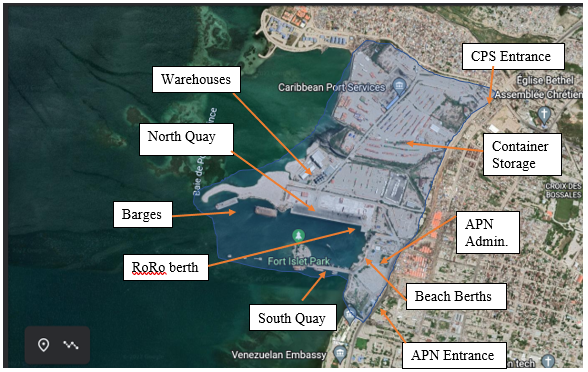
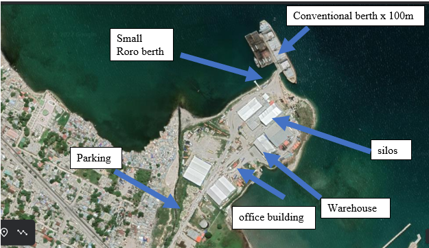
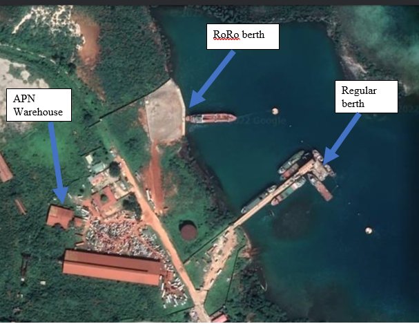
2.1.1 Haiti Port International de Port-au-Prince APN
Overview
Key port information may also be found at: http://www.maritime-database.com
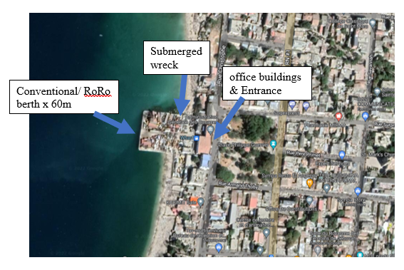
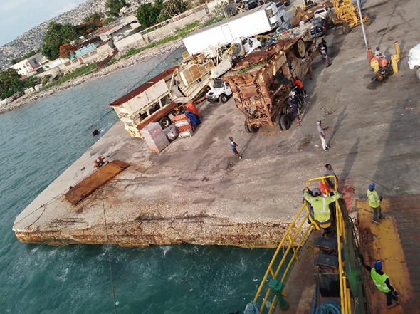
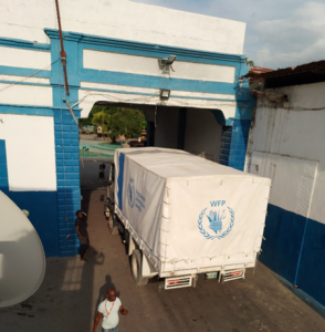
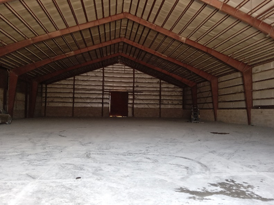
The International Port of Port-au-Prince (known as APN) was to be the centrepiece of a nationwide port rebuilding programme however progress has stalled. The first phase of redevelopment for Quai Nord was completed in June 2016. Port Lafito now competes as the premier container handling port for Port-au-Prince. Containerised cargo is handled at Quai Nord. Several container feeder services of global liner operators call at this port (MSC, CMA-CGM, ZIM, Maersk/Sealand, Antillean, DP World). The barges, which were temporary wharves during port reconstruction lie at the western end of Quai Nord and are still used for discharge of bulk commodities such as grain.
Quai Sud has not been developed and continues to be used by tugs, small craft and barges. There are no cargo operations at Quai Sud. There are small beach landings between Quai Nord and Quai Sud used for landing craft engaged in cabotage trade and ferry services. International container and bulk operations are managed by Caribbean Port Services who own the cargo handling equipment.
The International Port had a throughput of 180 000 TEUs in 2021. The port handled 277 vessel calls in 2021and 365 in 2020, with an average vessel call of seven hours.
Port website: Autorite Portuaire Nationale
|
Port Location and Contact |
|
|---|---|
|
Country |
Haiti |
|
Province or District |
Ouest Department |
|
Nearest Town or City Distance from Port |
Within Port-au-Prince |
|
Port's Complete Name |
International Port of Port-au-Prince (known as APN) |
|
Latitude |
18.556943 |
|
Longitude |
-72.350383 |
|
Managing Company or Port Authority |
Caribbean Port Services Autorite Portuaire Nationale |
|
Management Contact Person |
General Director- Ken Lacoste +509 4039 4784 |
|
Nearest Airport and Airlines with Frequent International Arrivals/Departures |
Toussaint Louverture Port-au-Prince International Airport |
Berthing Specifications
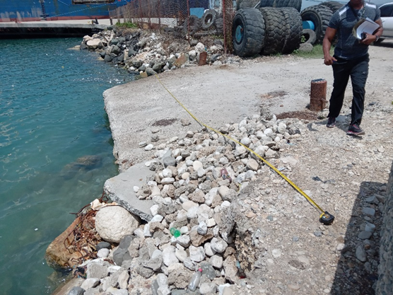
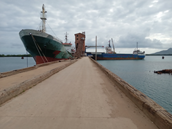
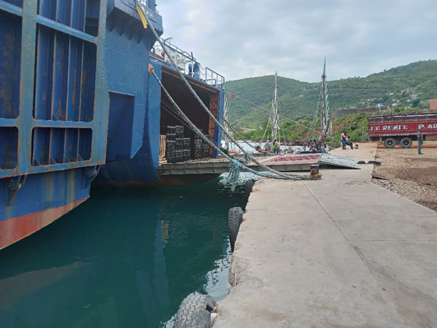
There are 5 tugs available, 3 Svitzer + 2 APN. Tug service is mandatory. 1 tug for vessels up to 150m LOA, 2 tugs for vessels greater than 150m LOA. North Quay and the RoRo ramp have good fenders and bollards. The cement structures are in good condition. The Barges at the Western end of North Quay have adequate fenders and bollards.
The Southern Quay is in reasonable condition but is crowded with many small vessels and tugs.
North Quay and RoRo berth showing DP World Feeder service vessel alongside. Access to RoRo berth can be blocked when there are containerships in port.
South Quay. Congested with tugs, barges and small craft. Coast Guard vessels also moored here. No cargo operations at South Quay.
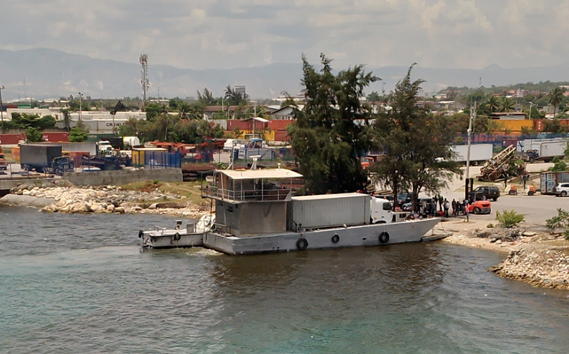
There are three beach berths between North and South Quays which can be used by landing craft.
|
Berth |
# |
Length |
Ht above SL |
Depth |
Notes |
|---|---|---|---|---|---|
|
North Quay |
1 |
410 m |
2.7 m |
11.5 m |
Mainly for container ships |
|
Barges |
3 |
120 m each |
2.0 |
11.5 m |
Bulk only |
|
RoRo Berth |
1 |
30 m |
1m |
6.6 m |
Bloced at times by containership operations |
|
South Quay |
2 |
200 m |
1.5 m |
6.5 m |
Congested. No cargo operations |
|
Beach berths |
3 |
|
N/A |
|
For landing craft |
Port Handling Equipment
Cargo handling equipment belongs to Caribbean Port Services (CPS). They manage the sizable container storage area in the northern section of the port. CPS has a separate entrance gate.
|
Item |
Quantity |
Brand/Mark |
Capacity |
|---|---|---|---|
|
Mobile cranes |
4 |
Gottwald/ Konecrane |
650,000 TEUs |
|
Reach -stackers |
10 |
Taylor |
|
|
Top- loaders |
9 |
Taylor |
|
|
Forklifts |
4 |
Taylor |
|
|
Evacuators/ conveyors |
N/A |
|
|
|
Grabs |
8 |
|
|
|
Bagging machines |
2 |
|
|
|
Hoppers |
4 |
|
|
|
Tanker storage |
N/A |
|
|
|
Mules |
30 |
|
|
|
Chassis |
200 |
|
|
|
Weighbridge |
1 |
|
|
|
Container storage area |
40 ha |
|
400,000 TEUs |
|
Container reefer points |
400 |
|
400 PLUGS |
|
Silos |
2 |
Caribbean Grain Company |
Rice |
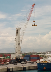
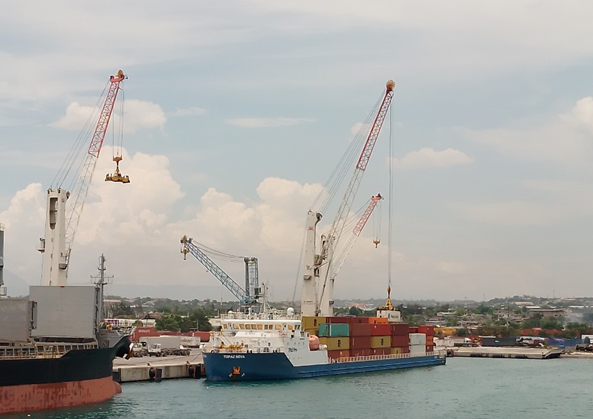
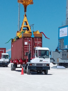
Mobile crane at North Quay
Storage Facilities
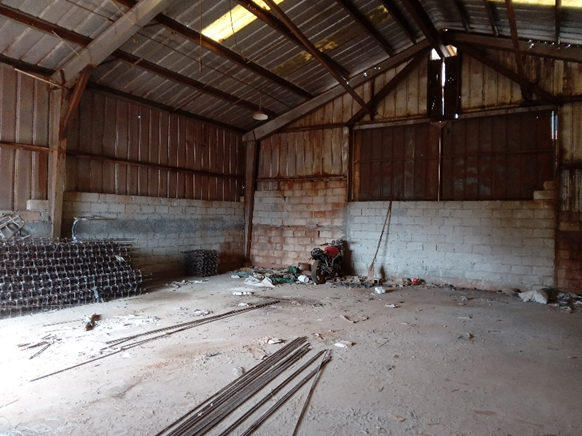
There is a 40-hectare container yard inside the port facility, in the northern section managed by CPS. The capacity is 400 000 TEUs and there are 400 reefer-points. The average container dwell time is 15 days and the facility is under Navis Octopi terminal operating system (TOS). The port reports 32 container movements per hour. There are warehouse facilities of 1850m2 which is projected to be expanded to 19,000 m2 in 2023. There are private silos on site which belong to Caribbean Grain company. They are used exclusively for rice.
Security and Access
The port has 24/7 security guards on duty. The area is not covered by CCTV. There are active security patrols within the port by armed guards. The port is surrounded by a high perimeter fence. There are two distinct entrances. CPS gate (Waaf Jeremie) in the north-east and APN in the south-east. CPS has their own security company patrolling the CPS section of the port. APN are responsible for security in the southern section of the port. The PFSOs work in close cooperation. The entire facility is situated in a zone that is subject to gang activity and sporadic violence. Access is restricted at times. (July 2022)
2.1.2 Haiti Port of Jacmel
Port Overview
The port of Jacmel is a small port operated under the supervision of APN in the Sud-Est Department of Haiti, next to the town of Jacmel. The port is inside the Baie de Jacmel and is partially protected by a fringing reef to the south-east. The port is quite exposed and experiences heavy swell at times. A pilot is available to guide vessels, but the approach is not complicated for shallow draft vessels. There are shifting sand banks on the approach to the port, due to the nearby river-mouth.
The port has a total workable surface of approximately 1700 sqm. Located on the southern coast of the country, it is the closest Haitian port to the Dominican Republic (Rio Haina and Caucedo). It does not receive shipments from major global shipping lines. Bulk carriers with their own cranes discharge cement. These are the only vessel calling regularly at the port (July 2022) There are occasional calls by large stern ramp RoRos discharging second-hand vehicles. There is no RoRo berth and smaller vessel would not be able to discharge due to the height of the main berth.
The small cement ramp, to the north of the main pier, is used by local craft and is too shallow for RoRo operations
There is a customs office (in town located in same facility as that of the aviation authorities).
The location of the port in the south of the island allows greater access to southern areas of the country in an emergency. However, there is very limited storage capacity and cargo traffic to Haiti is only moved through the port sporadically.
Port website: http://www.apn.gouv.ht/ Key port information may also be found at: http://www.maritime-database.com
|
Port Location and Contact |
|
|---|---|
|
Country |
Haiti |
|
Province or District |
Jacmel, Sud-Est Department |
|
Nearest Town or City |
Port-au-Prince 92km |
|
Latitude |
18.231357 |
|
Longitude |
-72.535773 |
|
Port Authority |
Autorite Portuaire Nationale APN |
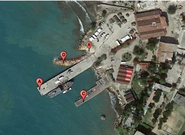
A - Commercial cargo wharf
B - Concrete landing ramp for small landing craft
C – Old Jetty not usable for commercial cargo. Wooden surface in poor repair
D - Stone mole limiting usage length of west side of wharf
Key Companies
Jacmel is operated under the supervision of APN (Autorite Portuaire Nationale). No stevedore companies or transporters are based at the port but can be arranged by port authorities. Joel Khawley is the principal importer in to Jacmel Port (July 2022) +509 3137 0101.
Handling Equipment
There is no shore-based cargo-handling equipment available at the port and no stevedore company. Forklifts can be sourced locally. There is no other cargo handling equipment. Ships must self-discharge. The pier is adequate to handle heavy trucks.
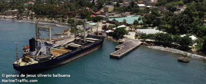
Pictured here is Mounie K which calls every few months with bagged cement from Dominican Republic.
Storage and Hinterland
There is no dedicated covered storage facility at the port. Cargo must be moved out of the port area directly. The cement apron is relatively small and there is not a large parking area. No transport companies are based at the port, but trucks can be hired from Port au Prince or other locations.
Berthing Specifications
|
Type of Berth |
# |
Length (m) |
Maximum Draft (m) Ht above Sea Level |
Comments |
|---|---|---|---|---|
|
Conventional Berth |
2 |
East 106 m West 50 m |
5 m / 2.7m above S/L |
Eastern berth has good fenders. Often in use as lay-by piers for idle vessels as port only used sporadically for significant cargo traffic. |
|
Old Jetty |
1 |
N/A |
3m/ 1.5m above S/L |
The wooden surface on this jetty is in very por condition with many planks missing. It could not withstand vehicle traffic. |
The main pier extends in a southerly direction. eastern showing the principal berth. Good fenders and bollards in place.
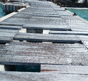
The old jetty showing poor condition of wooden planking.
Security and Access
The port fence is in poor condition. There is a private enterprise building and restoring fishing boats inside the port. Access is not very secure.
2.1.3 Haiti Port of Jeremie
Overview
Key port information may also be found at: http://www.maritime-database.com
The Port of Jeremie is a cabotage port and does not comply with ISPS. Main imports are cement and rice. There are vessel calls approximately every 15 days. The port is quite exposed to the east and is likely to experience considerable swell at times. APN ports are free for use by humanitarian organisations carrying cargo that has customs exemption. Fees may be charged for warehouse storage or for truck parking inside the port perimeter.

|
Port Location and Contact |
|
|---|---|
|
Country |
Haiti |
|
Province or District |
Grand Anse |
|
Nearest Town or City with Distance from Port |
Port-au-Prince 288km |
|
Port's Complete Name |
Port of Jeremie |
|
Latitude |
18.642941 |
|
Longitude |
-74.112007 |
|
Managing Company or Port Authority |
Autorite Portuaire Nationale (APN) |
|
Management Contact Person |
Louis Louisnes Director +509 4033 4775 |
|
Nearest Airport and Airlines with Frequent International Arrivals/Departures |
Toussaint Louverture Port-au-Prince International Airport |
Berthing Specifications
The port consists of a single pier oriented to the East. Total length of pier approx. 100m but only 40m is usable. The platform at the end of the pier was destroyed by Hurricane Matthew. The useable berth is to landward of the platform. The southern side of the pier is used most frequently. There are a few tyres hung as fenders. There 2 are substantial bollards on either side of the pier.
|
Type of Berth |
# |
Length (m) |
Height of berth from sea level |
Maximum Draft (m) |
Comments |
|---|---|---|---|---|---|
|
Conventional Berth |
1 |
40 |
2.3 m |
Reported to be 10 m |
The mid-section of the pier has potential 40m berths on either side. |
|
Roro Berth |
1 |
7.5 m |
2.3 m |
Reported to be 10 m |
Local vessel goes stern to, on an angle – as in Diagram. |
|
Container Berth |
0 |
|
|
|
|
|
Silo Berth |
0 |
|
|
|
|
|
Berthing Tugs |
0 |
|
|
|
|
|
Water Barges |
0 |
|
|
|
|
A stern-to or bow-to roro operation can be conducted at the angled berth half-way along the pier. There is no data on the strength of the pier, but it has been used with heavy vehicle traffic offloading cement.
Main berth looking East & seaward. Taken from ro-ro berth.
Damaged section of the end of the pier. This section is not useable.
Port Handling Equipment
There is no handling equipment and no official stevedoring company. The Port Director can organise stevedores if given a few days’ notice.
Storage Facilities
Adjacent to the office is a warehouse facility (10 m x 8 m). It is a substantial and well-maintained cement building with a tin roof. It has a smooth cement floor, raised step at door prevents ingress of water. Solid steel double doors which open outwards. Doors were locked. No electricity, though internal lights are fitted. This facility would be available at a discounted rate to WFP. There is a large hardstand area suitable for staging trucks, approximately 800 m2.
Security
The port has 27/7 security guards on duty. Th port is surrounded by a 2.5m high cement wall topped with coiled barbed wire. There is one entrance though a sliding steel gate. There is no electricity so although there are lights installed, they do not work.
Port Access
Access would be difficult for large trucks. The road immediately outside the port is seriously damaged. It is passable for light vehicles and small trucks.
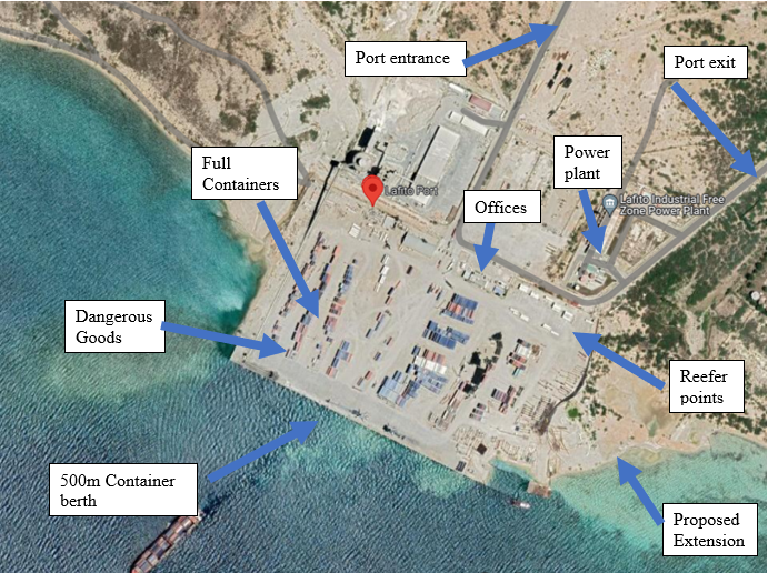
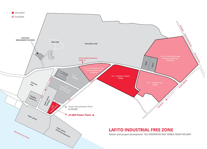
2.1.4 Haiti Port of Lafito
Port Overview
Key port information may also be found at: http://www.maritime-database.com
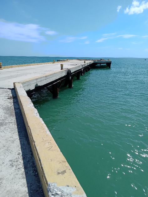
The Port of Port Lafito is a private international container terminal. Although it is privately owned it performs the function of an APN port. The complex covers 13 hectares. It is Haiti’s only Panamax Port and is owned by the GB Group who own the adjacent Industrial Free Zone (not yet operational) and a dryport in Port-au-Prince. The port was opened in 2015 and facilities are in good condition. The port is quite exposed with no breakwater and Ile a Cabrit offering some protection to the west.
Associated Industrial Zone
|
Port Location and Contact |
|
|---|---|
|
Country |
Haiti |
|
Province or District |
Ouest Department |
|
Nearest Town or City with Distance from Port |
Port-au-Prince 23km |
|
Port's Complete Name |
Port Lafito |
|
Latitude |
18.695235 |
|
Longitude |
-72.364897 |
|
Managing Company or Port Authority |
GB Group Autorite Portuaire Nationale (APN) |
|
Management Contact Person |
Director – M Guy William +509 37017545 Security – Garry Amadee +509 4865 2638 |
|
Nearest Airport and Airlines with Frequent International Arrivals/Departures |
Toussaint Louverture Port-au-Prince International Airport |
Berthing Specifications
The port is oriented to the NW-SE at has a single 450 m long berth. This extends to 500 m with the outstanding mooring dolphins. There is shallow water to the NW as visible in the port photo. This is primarily a container port, but there is a cement operation (Cimex) in the Northern section of the port and vessels are loaded with cement on occasions. Mobile crane discharging container vessel.
|
Berth |
# |
Length |
Ht above SL |
Depth |
Notes |
|---|---|---|---|---|---|
|
Conventional Berth |
1 |
|
2.7 m |
Reported to be 12.5 m |
NW end of the container berth Good fenders and bollards in place |
|
Roro Berth |
|
|
|
|
|
|
Container Berth |
1 |
450 m |
2.7 m |
Reported to be 12.5 m |
Extends to 500 m with outlying mooring dolphins |
|
Silo Berth |
0 |
|
|
|
|
|
Berthing Tugs |
0 |
|
|
|
Tugs must be ordered from Por-au-Prince making this an expensive service . |
|
Water Barges |
0 |
|
|
|
|
Port Handling Equipment
Port Lafito is managed by SSA Marine and operated Tideworks Terminals Software (TOS). Container moves are reported as 30/hr
|
Equipment |
Available |
Total Quantity and Capacity Available |
Comments on Current Condition and Actual Usage |
|---|---|---|---|
|
Mobile Cranes |
2 |
Leihberr LMH420 mobile cranes. 124 mt lifting capacity |
Active and in good condition |
|
Reach-stacker |
3 |
Taylor |
5 high |
|
Top-loaders |
4 |
Taylor |
5 high |
|
Mules |
10 |
|
|
|
Dedicated chassis |
300 |
|
|
|
Forklifts |
2 |
25 and 30 tonnes |
|
Storage Facilities
There is a container yard inside the port. Containers are stacked up to 3 high on compacted dirt hardstand. Containers are segregated as full, empty and dangerous goods. There are 30 reefer points. Port Lafito is owned by GB Group who own an associated dryport in Port-au-Prince
Security
The port has 24/7 security guards on duty. The uniformed guards were attentive both at the gate and inside the facility. The port is surrounded by a tall wire fence topped with coiled barbed wire. There is one entrance and one exit. A large independent power plant provides 24hr electricity and security lighting throughout the port complex. Fuel is trucked into the port.
Port Access
There is good access to the port. The road is clear and there is no local congestion.
2.1.5 Haiti Port of Cap Haitien
Port Overview
Key port information may also be found at: http://www.maritime-database.com
Cap Haitian is the second most important port facility in Haiti after Port-au-Prince regional ports which encompass APN, Terminal Varreux and Port Lafito.. The strategic position on the north coast and close to Dominican Republic makes Cap Haitian an excellent entrance point to the country. Unfortunately, national insecurity and the poor condition of the roads to Gonaives and Port-au-Prince mean that the port is not well connected to the rest of Haiti.
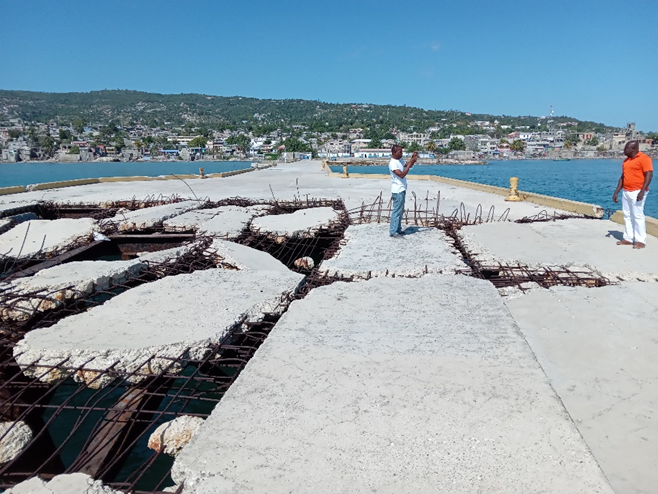
The port lies on the western side of Baie de Cap Haitien. There are numerous reefs on the approach from the north. Navigation marks and lights are reported to be in place an operational (June 2022). The pilot boat is out of service (June 2022). The port is quite exposed to easterly trade winds, particularly Quay #1, the cruise ship berth.
In June 2022 the port was receiving 3 container ships per week and 2 bulk carriers per month. There are also frequent international shipments on dumb (propelled by tug boats) barges importing second-hand goods from Florida and Turks and Caicos.
Cap Terminal run the adjacent container yard and own the cranes within the port. They also provide stevedoring services. Cap Terminal | Home
|
Port Location and Contact |
|
|---|---|
|
Country |
Haiti |
|
Province or District |
Nord Department |
|
Nearest City with Distance from Port |
Port-au-Prince (200 km) |
|
Port's Complete Name |
Port de Cap Haitian |
|
Latitude |
19.75949 |
|
Longitude |
-72.19547 |
|
Managing Company or Port Authority |
Autorite Portuaire Nationale (APN) Cap Terminal SA (CTSA) |
|
Management Contact Person |
APN Port Director – Pierre Richard Joseph +509 3101 2222 Security PFSO – Pierre Gerald Gay +509 3631 2587 |
|
Nearest Airport and Airlines with Frequent International Arrivals/Departures |
Cap Haitian Airport (5 km) Toussaint Louverture Port-au-Prince International Airport (200 km) |
Port Picture

Berthing Specifications

There are two main quays at right angles, both have adequate fenders and regular bollards along their length. Pier 1 is augmented by the off-standing dolphin to accommodate larger vessels. The cement aprons are in good condition. Aprons are wide enough for direct discharge onto trucks. The pedestrian bridge connecting quay 1 to the port is severely damages and cannot be used. The cabotage both is very active with both motorised and sailing vessels crowding the berth.
|
Berth |
# |
Length |
Ht above SL |
Depth |
Notes |
|---|---|---|---|---|---|
|
Conventional/ Container Berth |
2 |
176 (with dolphin) 250 m |
2.5m |
10.5m is deepest draft at quay 1
|
Good fenders and bollards in place |
|
250 m |
9.5 m is deepest draft at quay 2 |
||||
|
Roro Berth |
1 |
24 m |
1.4 m |
9.5 m is deepest draft at RoRo berth |
Well-constructed RoRo berth |
|
Berthing Tugs |
2 |
|
|
|
Tugs are available |
|
Water Barges |
0 |
|
|
|
|

The RoRo berth, between quay 2 and the cabotage berth, is well constructed. There are adequate bollards for securing a vessel. Access may be blocked when there are vessels at quay 2.
Port Handling Equipment
Cap Terminal owns both mobile cranes operating in the port. The cranes can service quays 1 and 2. The newest crane came into service in 2021. Discharge rate is reported to be 17 moves/hr. Cap Terminal provide crane operators and stevedores for 24/7 operations. Cap Terminal and other private operators own the cargo handling equipment, such as forklifts in use throughout the port. The weighbridge is out of service (June 2022).
‘Bull Rice’ has privately owned grabs and mobile bagging machines in the port. Rice arrives in bulk and is bagged at the quayside and stored in the large private warehouse on the wharf. Port congestion may be experienced when there is a rice ship in port.
Cement arrives bagged and palletised and is stored in private warehouses on the wharf.
Prestige shipping also offer stevedoring and storage Prestige Ship Services

Cap Terminal’s new crane. Installed in 2021. SWL is 50 MT and is capable of 17 movements per hour.

Spreader bars are available for 20’ & 40’ containers are available in the port. Not remotely operated.

Portable grab and hopper for bulk cargo owned by Bull Rice who bags rice at the quayside.

Mobile bagging machine. Accurate bagging rate was not available.
|
Equipment |
Available |
Total Quantity and Capacity Available |
Comments on Current Condition and Actual Usage |
|---|---|---|---|
|
Mobile Cranes |
2 |
Cap Terminal |
Terex-built (2014)
|
|
Reach-stacker |
1 |
Cap Terminal |
3 high |
|
Top-loaders |
2 |
Cap Terminal |
3 high |
|
Mules |
0 |
Cap Terminal |
N/A |
|
Dedicated chassis |
4 |
Cap Terminal |
More can be rented |
|
Forklifts |
several |
|
Privately owned. Some in poor condition |
Storage Facilities
Containers are stored in the adjacent Cap Terminal compound. There is capacity for 2000 TEUs and 20 plugs for reefers. There are 2 generators running 24/7. Dwell time is 5/6 days for commercial cargo. Additionally, there is a dry-port under construction, managed by Cap Terminal 10km from the port with a capacity of 3000 TEUs. There are large private warehouses withing the port for rice and cement. The molasses tank is out of service. There is a large parking area for imported vehicles.

There is one APN warehouse in poor condition. 10 x 60 m, 800 MT capacity.
Security
The port is compliant with ISPS International ship security code. There are 24/7 security guards on duty. The uniformed guards were attentive both at the gate and inside the facility. The port is surrounded by a tall wire fence topped with coiled barbed wire. There is one entrance and one exit.
There is extensive lighting throughout the port, reported to be in good working order.
Port Access
Access is difficult as the port is in the centre of town. Large trucks have difficulty manoeuvring through the tight entrance. Traffic congestion restricts ease of access to the port. Connectivity to rest of Haiti is limited by national road security issues and the poor condition of the roads.
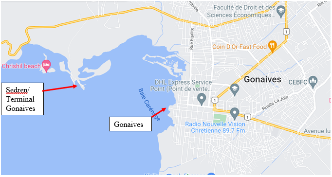
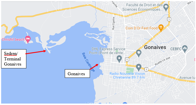
2.1.6 Haiti Port of Gonaives (public port)
Port Overview
Key port information may also be found at: http://www.maritime-database.com
The Ports of Gonaives and Sedren/Terminal Gonaives both lie withing the Baie de Gonaives. They are separate facilities. Both are managed by APN, but Sedren/Terminal Gonaives is reputed to have private ownership. The port in the centre of the town of Gonaives is largely derelict. Sedren/Terminal Gonaives is the more developed port, it was originally constructed as a port to export bauxite mined in the area. Ownership of Sedren/Terminal Gonaives is contested and there is no regular vessel schedule.
Key port information may also be found at: http://www.maritime-database.com
|
Port Location and Contact |
|
|
Country |
Haiti |
|
Province or District |
Artibonite Department |
|
Nearest Town or City with Distance from Port |
Port-au-Prince (142 km) |
|
Port's Complete Name |
Port of Gonaives |
|
Latitude |
19.44793 |
|
Longitude |
-72.69668 |
|
Managing Company or Port Authority |
Autorite Portuaire Nationale (APN) |
|
Management Contact Person |
Directrice - Mme Fleurette + 509 3220 4514
Technical – Pierre Michel St-Armand +509 3323 7337 |
|
Nearest Airport and Airlines with Frequent International Arrivals/Departures |
Toussaint Louverture Port-au-Prince International Airport Cap Haitian Airport |
The APN office is in this port. The wharf is dilapidated and unmaintained. There is a pile of boulders in the middle of the quay making it almost impossible to be used. The port area is small and there are no storage facilities. The presence of numerous wrecks makes the approach to the berth treacherous. There is a derelict vessel blocking the potentially most useable berth. This port is used by very small coastal traders, sailing cargo boats and fishing boats. APN ports are free for use by humanitarian organisations carrying cargo that has customs exemption.
Port Pictures
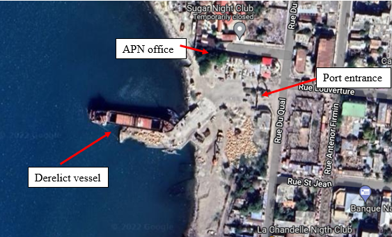
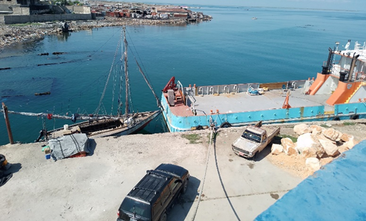
Berth used by small coastal vessels. There are many submerged wrecks on the approach.

End of the pier in ruins. Large pile of boulders blocks the access. Derelict vessel in only potentially useable berth.
Berthing Specifications
|
Type of Berth |
# |
Length |
Height of berth from sea level |
Maximum Draft (m) |
Comments |
|---|---|---|---|---|---|
|
Conventional Berth/ Ro-Ro |
1 |
50 m |
1.0 m |
|
Many wrecks in area. Silting is likely. Depth unknown |
The dog-leg pier is oriented East-West and is well protected deep inside the Baie des Gonaives. There is a very small cement apron littered with boulders. The berth is about 50 m long. The entire wharf is in extremely poor condition The height of the wharf above sea-level is 1.0 m.
Port Handling Equipment
There is no handling cargo equipment in the port.
Storage Facilities
There are no storage facilities.
Security
Security officers are present. The port has a high perimeter wall at the gate but can be easily accessed along the shore.
Port Access
The port is in the centre of town and there is reasonable road access. Traffic congestion might cause some issues at the port entrance at times.
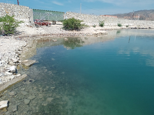
2.1.7 Haiti Port of Gonaives (Sedren Terminal)
Port Overview
The Ports of Gonaives and Sedren/Terminal Gonaives both lie withing the Baie de Gonaives. They are separate facilities. Both are managed by APN, but Sedren/Terminal Gonaives is reputed to have private ownership. The port in the centre of the town of Gonaives is largely derelict. Sedren/Terminal Gonaives is the more developed port, it was originally constructed as a port to export bauxite mined in the area. Ownership of Sedren/Terminal Gonaives is contested and there is no regular vessel schedule.
There are no office facilities at this port. The port is currently closed (June 2022), and ownership is contested.
Key port information may also be found at http://www.maritime-database.com
|
Port Location and Contact |
|
|
Country |
Haiti |
|
Province or District |
Artibonite Department |
|
Nearest Town or City with Distance from Port |
Port-au-Prince (148 km) |
| Port's Complete Name | Sedren/Terminal Gonaives |
|
Latitude |
19.45240 |
|
Longitude |
-72.71670 |
|
Managing Company or Port Authority |
Autorite Portuaire Nationale (APN)/ private ownership contested. |
|
Nearest Airport and Airlines with Frequent International Arrivals/Departures |
Toussaint Louverture, Port-au-Prince International Airport, Cap Haitian |
Port Picture
Berthing Specifications
The conventional berth is oriented NE-SW and is well protected inside the bay. The pier face is in poor condition with no real fenders and exposed reinforcing bar. There is a potential RoRo ramp, but the area is heavily silted, and ship ramps are not likely to reach dry land. This could make discharge of heavy vehicles impossible.
|
Type of Berth |
# |
Length |
Height of berth from sea level |
Comments |
|---|---|---|---|---|
|
Conventional Berth/ Ro-Ro |
1 |
35 m |
2.0 m |
Depth unknown. Small bollard at either end of berth |
|
RoRo berth |
1 |
|
|
Beach with rock groyne. No mooring facilities |

Conventional berth
Heavily-silted Roro berth
Port Handling Equipment
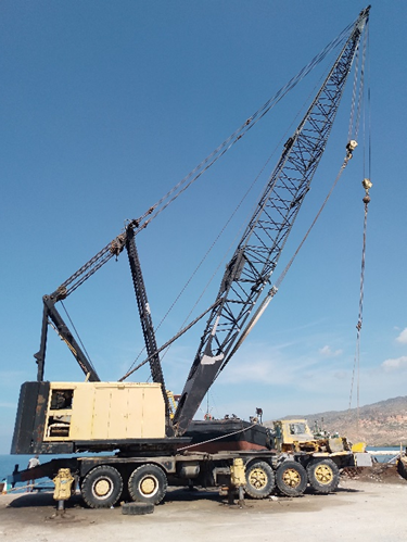
There is a crane onsite, but there is no evidence that this crane works.
Storage Facilities
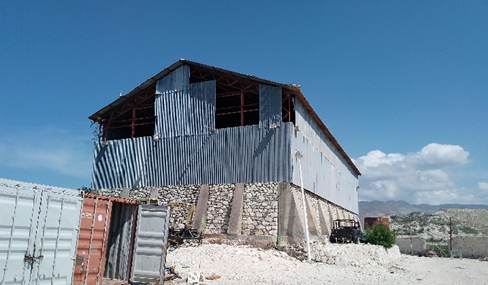
The existing warehouse is in poor condition. The original construction is sound, but sheets of tin and one door are missing. Dimensions (35 m x 14 m). The port area is littered with disused containers. There would be plenty of room for container storage.
Security
Security officers are present. There is a wire-topped 2 m wall around much of the facility & 2 m wire fence in other places. The fences and walls are not well maintained.
Port Access
The port is 5 km from the centre of Gonaives. The last 1.6km is along a poorly maintained unpaved road. This may cause issues in the rainy season.
2.1.8 Haiti Port of Carriès
Port Overview
The port is used for serving the island of La Gonave, both with a ferry-like passenger vessel and local wooden vessels. No international traffic is handled. The port is located very close to the main road (N1) connecting Port-au-Prince and Carriès.
Key port information may also be found at: http://www.maritime-database.com
|
Port Location and Contact |
|
|
Country |
Haiti |
|
Province or District |
Ouest Department |
|
Nearest Town or City with Distance from Port |
Cabaret (29 km) Port Au Principe (57 km) |
|
Port's Complete Name |
Cariesse Ferry Terminal |
|
Latitude |
18.88898 |
|
Longitude |
-72.62295 |
|
Managing Company or Port Authority |
Autorité Portuaire Nationale (APN) |
|
Management Contact Person |
apnpap@apn.gouv.ht (generic APN contact email) |
|
Nearest Airport and Airlines with Frequent International Arrivals/Departures |
Port-au-Prince International Airport (PAP) Aerolineas Mas Air Canada Air France American Airlines Delta Airlines |
Port Picture

Berthing Specifications
|
Type of Berth |
Quantity |
Length (m) |
Maximum Draft (m) |
Comments |
|
Conventional Berth |
1 |
30 |
4.5 |
Ferry Terminal |
|
Conventional Berth |
1 |
90 |
5.8 |
Main Wharf |
|
Container Berth |
0 |
|
|
|
|
Silo Berth |
0 |
|
|
|
|
Berthing Tugs |
0 |
|
|
|
|
Water Barges |
0 |
|
|
|
The main wharf (“ferry terminal”) is built on piles, therefore a weight limitation for working with port handling equipment must be kept in mind.
Port Handling Equipment
No shore based cargo handling equipment is positioned in the port. Vessel loading / unloading is done manually/manpower.
Storage Facilities
Within the direct port area, no storage facilities are available.
2.1.9 Haiti Port of Saint Marc
Overview
Key port information may also be found at: http://www.maritime-database.com
The Port of Saint-Marc was previously a regular port of call for RoRo vessels from Miami. It is now primarily a cabotage port, but customs service is available and some imports such as cement arrive in the port. Vessel calls are irregular. There is no port schedule. The port buildings are in good condition, but the wharf is dilapidated and unmaintained. The port area is small and crowded with derelict machinery. The port is very exposed and considerable swell makes it an uncomfortable dock to stay alongside. There are no navigational hazards on the port approach.
APN ports are free for use by humanitarian organisations carrying cargo that has customs exemption. There are limited warehouse facilities available inside the port.
|
Port Location and Contact |
|
|---|---|
|
Country |
Haiti |
|
Province or District |
Ouest Department |
|
Nearest Town or City with Distance from Port |
Port-au-Prince (88 km) Gonaives (56 km) |
|
Port's Complete Name |
Port of Saint-Marc |
|
Latitude |
19.109536 |
|
Longitude |
-72.702505 |
|
Managing Company or Port Authority |
Autorite Portuaire Nationale (APN) |
|
Management Contact Person |
Director: Nola Marius (+509 3800-8157) Security: M Crescent (+509 3686-9239) |
|
Nearest Airport and Airlines with Frequent International Arrivals/Departures |
Toussaint Louverture Port-au-Prince International Airport |
Berthing Specifications
The pier is oriented North/South and is extremely exposed. There is a basic cement apron very cluttered with derelict machinery. The berth is about 60m long with a single bollard at either end. The pier wall is broken with exposed reinforcing bar and no fenders. The height of the wharf above sea-level is 1.7m and is used frequently by RoRo vessels.
|
Type of Berth |
# |
Length (m) |
Height of berth from sea level |
Maximum Draft (m) |
Comments |
|---|---|---|---|---|---|
|
Conventional Berth/ Ro-Ro |
1 |
60 m |
1.7 m |
10 m reported |
Solid cement apron. Berth is in poor condition with no fenders |
|
Container Berth |
0 |
|
|
|
|
|
Silo Berth |
0 |
|
|
|
|
|
Berthing Tugs |
0 |
|
|
|
|
|
Water Barges |
0 |
|
|
|
|
Port Handling Equipment
There is no handling cargo equipment in the port. Stevedoring can be organised.
Storage Facilities
There is a well-maintained warehouse facility. It is a substantial cement building with a tin roof. It has a smooth cement floor. There are small, locked steel doors. Dimensions: 15 m x 20 m. The is no parking area and the derelict machinery throughout the port make it difficult to manoeuvre long trucks.
Security
The port has 24/7 security guards on duty. The port is surrounded by a 2.5m high wire fence topped with coiled barbed wire. There is one entrance though a sliding steel gate. There are solar powered lights throughout the port complex. Which provide weak lighting most of the night.
Port Access
The port is in the centre of town and there is reasonable road access. Traffic congestion might cause some issues at the port entrance at times.
2.1.10 Haiti Port of Les Cayes
Port Overview
Key port information may also be found at: http://www.maritime-database.com
The Port of Les Cayes is an import port, primarily cement from Dominican Republic. There are vessel calls approximately once per month. Vessels do not enter the port. They anchor in the roads and are discharged by small local craft with outboard motors. The port is quite exposed to the east and is likely to experience considerable swell at times. There are several reefs near the entrance and navigation is hazardous. The channel buoys indicated on the chart are not in place. The wreck of the Saint Simon is adjacent to the tourist wharf.
There is no commercial wharf.
APN, SEMANAH and Customs have offices inside the port. APN ports are free for use by humanitarian organisations carrying cargo that has customs exemption. Fees may be charged for warehouse storage or for truck parking inside the port perimeter.
|
Port Location and Contact |
|
|---|---|
|
Country |
Haiti |
|
Province or District |
Department du Sud |
|
Nearest Town or City with Distance from Port |
Port-au-Prince (200 km) |
|
Port's Complete Name |
Port of Les Cayes |
|
Latitude |
18.189937 |
|
Longitude |
-73.748127 |
|
Managing Company or Port Authority |
Autorite Portuaire Nationale (APN) |
|
Management Contact Person |
Director - Saint Thomas Rochelle +509 3387 7733 Customs – Gary Clervue +509 4878 9851 |
|
Nearest Airport and Airlines with Frequent International Arrivals/Departures |
Toussaint Louverture Port-au-Prince International Airport |
Berthing Specifications
The port consists of 2 piers oriented to the East. The port is exposed to the East and experiences choppy conditions and heavy swell at times. The pier withing the APN port is only suitable for small shallow draft vessel and is used by tourist boats servicing nearby Ile a Vache. The wharf is in good condition. The second pier belongs to the Coast Guard and is accessed via their secure compound. The Coast Guard would make the pier available. The pier has suffered considerable damage in the 2021 earthquake. It is not advisable to bring a vessel alongside to discharging cargo on this wharf. The area between the piers is being filled with rubble from cement buildings destroyed on the earthquake.
Les Cayes should only be considered if the operation suits a vessel being anchored offshore and discharging into small local boats. It may be possible to arrive at the shore with a landing craft, but extensive local knowledge would be required.
There is no formal stevedoring company.
Port Handling Equipment
There is no handling equipment and no official stevedoring company. Cargo is discharged by small local boats.
Storage Facilities
There are no storage facilities.
Security
In the APN port there is no security, no perimeter fence, and no gate. There are several private enterprises inside the port area including a bar. There are some street-lights which are reported to be working. There is no electricity in the port building, although there is a generator. The Coats Guard compound is well secured. There are security guards 24/7 and a solid perimeter fence. There is one entrance via a sliding steel gate.
Port Access
There is reasonable access for small trucks. Holes in the road make it impractical for large heavy vehicles.
Port Office and access road.
The tourist pier looking towards the port.
The coast guard pier from the coast guard
office.
2.1.11 Haiti Port of Terminal Abraham
Port Overview
Key port information may also be found at: http://www.maritime-database.com
Terminal Abraham is a private facility owned by the Khawly family. It is principally a bulk commodity port with a single pier. Main imports are grain and cement. Wheat is ground into flour and bagged on site. Animal fodder is mixed and bagged on site.
There is also a small RoRo berth used by coastal transporters.
|
Port Location and Contact |
|
|---|---|
|
Country |
Haiti |
|
Province or District |
Ouest Department |
|
Nearest Town or City with Distance from Port |
Port-au-Prince (15 km) Currently National Highway 2 is blocked, and vehicles cannot pass. |
|
Port's Complete Name |
Port of Terminal Abraham |
|
Latitude |
18.543348 |
|
Longitude |
-72.388821 |
|
Managing Company or Port Authority |
Terminal Abraham |
|
Management Contact Person |
Director – Jeff Khawly Security – Estime Luccene +509 3713 9407 |
|
Nearest Airport and Airlines with Frequent International Arrivals/Departures |
Toussaint Louverture Port-au-Prince International Airport |
Berthing Specifications
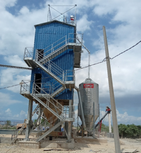
There is a single 100 m x 10 m finger pier extending NNW from the shore. It is very exposed to westerly winds. The pier is in reasonable condition and there is frequently a cargo barge, used to transport heavy fuels, on the shoreward side of the pier. Bulk carriers dock on the seaward side and self-discharge into trucks. The trucks then tip their loads into hoppers and conveyors transfer the grain to silos.
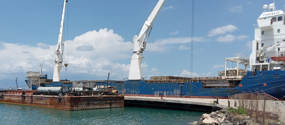
There is a small RoRo berth inside the pier. It is a narrow cement structure with 2 small bollards. The ramp is 6.6 m wide.
|
Type of Berth |
# |
Length (m) |
Height of berth from sea level |
Maximum Draft (m) |
Comments |
|---|---|---|---|---|---|
|
Conventional Berth |
1 |
100 m |
2.7m |
Reported to be 12m |
Shoreside berth usually occupied by dumb barge. |
|
Roro Berth |
1 |
6.6 m wide |
0.8 m |
Reported to be 4m |
Only for vessels with narrow ramps. |
|
Container Berth |
0 |
|
|
|
|
|
Silo Berth |
0 |
|
|
|
|
|
Berthing Tugs |
0 |
|
|
|
|
|
Water Barges |
0 |
|
|
|
|
Port Handling Equipment
The port has several enterprises operating withing the facility. Cereal d ’Haiti stores and processes wheat to flour. SHAB is mixing and bagging animal feed. There is a large workforce withing the general facility. There are 2 weighbridges.
|
Equipment |
Available |
Total Quantity and Capacity Available |
Comments on Current Condition and Actual Usage |
|---|---|---|---|
|
Dockside Crane |
No |
|
|
|
Container Gantries |
No |
|
|
|
Mobile Cranes |
No |
|
|
|
Reachstacker |
No |
|
|
|
RoRo Tugmaster (with Trailer) |
No |
|
|
|
Grain Elevator with Bagging Machines |
Yes |
|
|
|
Transtainer |
No |
|
|
|
Forklifts |
7 |
|
Used in warehouses |
Storage Facilities
Trucks dump grain in an underground hopper which is then lifted to storage silos with conveyors.
There are 2 excellent warehouse facilities with double access and smooth cement floors. Doors are locked. There is little ventilation. (46 m x 30 m).
There are limited areas for parking and much of the available area is cluttered with broken machinery. There is no officially designated parking zone.
Security
The port has 24/7 security guards on duty. The uniformed guards were attentive both at the gate and inside the facility. We passed through 2 security checks and there was additional security at the pier. The port is surrounded by a 3 high wire fence topped with coiled barbed wire. There is one entrance though a sliding steel gate. There are sections of the fence that are in poor condition.
Port Access
The area of Carrefour is extremely congested, and trucks move slowly outside the gate.
2.1.12 Haiti Port of Saint Louie de Sud
Port Overview
Key port information may also be found at: http://www.maritime-database.com
The Port of Saint Louis du Sud is a private port. There has only been one vessel call since the port was constructed. The Danica Sunbeam was chartered by WFP as part of the 2021 Les Cayes earthquake response and discharged bagged rice in the port. The port deep and well sheltered. The entrance to the port is straightforward. There are no channel marks. There is a port boat which can assist with mooring. The wharf suffered some damage in the Les Cayes earthquake but is still serviceable. There is a single commercial wharf. APN, SEMANAH and Customs have offices inside the port. Port fees are charged in this port. USD 200/truck for roro vessels.
The port consists of 1 deep sheltered berth 50m long. There are 4 reasonable bollards along the wharf. There are sturdy tyres placed as fenders. The height of the wharf is 2.4 m. It would be possible to conduct roro operations from the NE end of the pier. There is a newly formed association of stevedores from the local community.
|
Port Location and Contact |
|
|---|---|
|
Country |
Haiti |
|
Province or District |
Department du Sud |
|
Nearest Town or City with Distance from Port |
Port-au-Prince (176 km) Les Cayes (37 km) |
|
Port's Complete Name |
Port of Saint Louis du Sud |
|
Latitude |
18.258667 |
|
Longitude |
-73.557644 |
|
Managing Company or Port Authority |
Port du Saint Louis du Sud |
|
Management Contact Person |
Director – Milot Zephir +509 3486 3360 Security – Jorile Adrien +509 4645 4375 |
|
Nearest Airport and Airlines with Frequent International Arrivals/Departures |
Toussaint Louverture Port-au-Prince International Airport |
Berthing Specifications
|
Type of Berth |
# |
Length (m) |
Height of berth from sea level |
Maximum Draft (m) |
Comments |
|---|---|---|---|---|---|
|
Conventional Berth |
1 |
50 |
2.4 m |
12 m |
This is a well-protected berth |
|
Roro Berth |
1 |
|
|
|
NE end of pier Not an official berth but could be used. |
|
Container Berth |
0 |
|
|
|
|
|
Silo Berth |
0 |
|
|
|
|
|
Berthing Tugs |
0 |
|
|
|
|
|
Water Barges |
0 |
|
|
|
|
Port Handling Equipment
There is no handling equipment.
Storage Facilities
There is a secure flat area adjacent to the port where MSUs can be erected.
Security
The port is well fenced and there is 24/7 security on guard. There is one access via a sliding gate. The port has security lighting. The adjacent storage area is also well-fenced and secured.
Port Access
Access is via a 7km unpaved road. The road is new and poorly maintained. There re large puddle of standing water which may cause issues in the rainy season. The road will require considerable maintenance to remain serviceable by trucks.
Main Berth
Earthquake damage
RoRo berth
2.1.13 Haiti Port of Petit Goave
Port Overview
Key port information may also be found at: http://www.maritime-database.com
The Port of Petit Goave is primarily a cabotage port, but customs service is available and some imports such as cement arrive in the port. Vessel calls are irregular. There is no port schedule. The port was extensively renovated in 2015 and facilities are in good condition. The port is reasonably protected inside the bay with protection from the prevailing Easterly winds. There are no navigational hazards on the port approach.
APN ports are free for use by humanitarian organisations carrying cargo that has customs exemption. There is no fee for use of the warehouse or parking at Petit Goave.
|
Port Location and Contact |
|
|---|---|
|
Country |
Haiti |
|
Province or District |
Ouest Department |
|
Nearest Town or City with Distance from Port |
Port-au-Prince (74 km) Miragoane (24 km) |
|
Port's Complete Name |
Port of Petit Goave |
|
Latitude |
18.430994 |
|
Longitude |
-72.870382 |
|
Managing Company or Port Authority |
Autorite Portuaire Nationale (APN) |
|
Management Contact Person |
Director - Mme Carole Exavier +509 4626 4074 Security - Legrand Abellar +509 3674 5499 |
|
Nearest Airport and Airlines with Frequent International Arrivals/Departures |
Toussaint Louverture Port-au-Prince International Airport |
Berthing Specifications
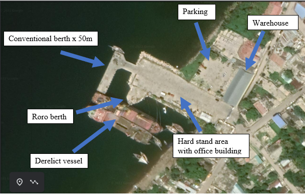
The pier is oriented to the NW at has a single T berth. The Ro-or berth is on the southern side of the pier as indicated above. Vessels approach the roro berth on an angle and make fast to the T berth and the derelict vessel (Maelys1). The pier is in good condition and there is a large hard cement hard stand for staging trucks. There are are adequate fenders and bollards.
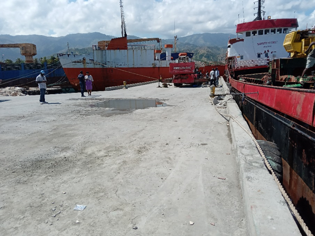
The T berth pictured with a vessel alongside and the vessel behind at the roro berth. The crane on the dock belongs to a private entity, Khawley.
|
Type of Berth |
# |
Length (m) |
Height of berth from sea level |
Maximum Draft (m) |
Comments |
|---|---|---|---|---|---|
|
Conventional Berth |
1 |
52 m |
2.7 m |
Reported to be 10 m |
Good fenders and bollards in place |
|
Roro Berth |
1 |
20 m |
1 m |
Reported to be 10 m |
Vessels approach on angle between T berth and derelict vessel |
|
Container Berth |
0 |
|
|
|
|
|
Silo Berth |
0 |
|
|
|
|
|
Berthing Tugs |
0 |
|
|
|
|
|
Water Barges |
0 |
|
|
|
|
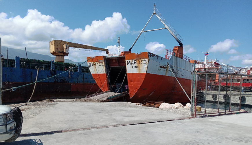
The roro berth with a vessel secured between the T berth and the derelict vessel.
Port Handling Equipment
There is no handling equipment and no official stevedoring company. The Port Director can organise stevedores if given a few days’ notice.
Storage Facilities
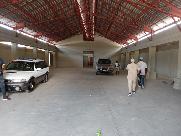
There is a well-maintained warehouse facility. It is a substantial cement building with a tin roof. It has a smooth cement floor and good natural light and ventilation. Solid steel double sliding doors. Doors were locked. Dimensions 20 m x 25 m. The is a secure parking area adjacent to the hard stand. It is fully fenced and guarded.
Security
The port has 27/7 security guards on duty. The uniformed guards were attentive both at the gate and inside the facility. The port is surrounded by a 2.5 m high wire fence topped with coiled barbed wire. There is one entrance though a sliding steel gate. There are solar powered lights throughout the port complex.
Port Access
There is good access to the port, although waiting trucks may cause some congestion outside the port. Trucks do not have to pass through the centre of town to access the port.
2.1.14 Haiti Port of Miragaone
Port Overview
Key port information may also be found at: http://www.maritime-database.com
The Port of Miragoane is located at Reynolds Terminal, 3.2 km west of the town centre. It is an active import port and there is a regular service from Florida with used cars and second-hand clothes. There are frequent vessel calls. No data was available on the exact number of vessel calls. APN, SEMANAH and Customs are present in the port. The port is extremely well protected. There are two entrance channels, from the north and east-south-east. It is likely that the channel markers are not in place. Reynolds Terminal was the site of bauxite exports from 1960s to 1980s.
APN ports are free for use by humanitarian organisations carrying cargo that has customs exemption. Fees may be charged for warehouse storage or for truck parking inside the port perimeter.
|
Port Location and Contact |
|
|---|---|
|
Country |
Haiti |
|
Province or District |
Nippes |
|
Nearest Town or City with Distance from Port |
Miragoane (3.2 km) Port-au-Prince (106 km) |
|
Port's Complete Name |
Port of Miragaone – Reynolds Terminal |
|
Latitude |
18.449227 |
|
Longitude |
-73.107474 |
|
Managing Company or Port Authority |
Autorite Portuaire Nationale (APN) |
|
Management Contact Person |
Odregue Terezin- Port Captain +509 3732 6174 Roland LeConte- Security +509 3710 0277 |
|
Nearest Airport and Airlines with Frequent International Arrivals/Departures |
Toussaint Louverture Port-au-Prince International Airport |
Berthing Specifications
The former bauxite wharf is now the principal commercial wharf. The northern side of the wharf has laid-up ships berthed alongside. The T berth at the end of the wharf is the main berth. The wharf is partially obstructed by the obsolete remains of the bauxite export conveyor. Cabotage vessels use the inner berths.
Main wharf showing laid-up vessels and old bauxite export infrastructure. There are ‘dolphins’ at either end of the T berth to facilitate larger vessels. A Cabotage vessel is on the inner berth. Trucks can access the T berth.
There is a dedicated RoRo berth north of the conventional berth. The berth has a large mooring buoy for vessels to secure to when moored at the berth. There is a large hard stand for vehicles. There is sufficient space for 2 vessels, as pictured below.
RoRo berth has adequate fenders and bollards.
|
Type of Berth |
# |
Length (m) |
Height of berth from sea level |
Maximum Draft (m) |
Comments |
|---|---|---|---|---|---|
|
Conventional Berth |
1 |
35 |
2.7 m |
Reported to be 10 m |
‘dolphins’ at either end of the berth increase the size of vessel that can be accommodated. |
|
Roro Berth |
1 |
50 |
1.1 m |
Reported to be 10 m, but probably less |
Enough space to accommodate 2 large roro vessels |
|
Container Berth |
0 |
|
|
|
|
|
Silo Berth |
0 |
|
|
|
|
|
Berthing Tugs |
0 |
|
|
|
|
|
Water Barges |
0 |
|
|
|
|
Port Handling Equipment
There is no handling equipment.
There is a stevedoring company. Jean Robert Guerrier +509 3709 2644
Storage Facilities
There is an APN warehouse within the port compound behind the office. It is a corrugated iron and cement construction with a locked door. The building is in poor condition and not clean. Dimensions: 28x 18m
Security
The port has 27/7 security guards on duty. Security guards are dressed informally and are heavily armed. The port is surrounded by a 2.5 m high fence. In some parts it is a wire fence and in others a cement wall. There is one entrance though a sliding steel gate. Overnight parking is available within the port. There is no electricity so although there are lights installed, they do not work. There are two generators adjacent to the APN office.
Port Access
Access is good for all sizes of trucks. The trucks do not have to pass through the centre of Miragoane.
2.1.15 Haiti Port of Les Moulins d’Haiti
Port Overview
Key port information may also be found at: http://www.maritime-database.com
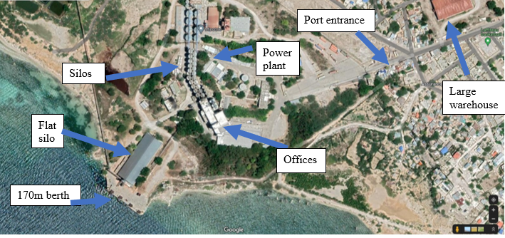
The Port of Moulin de Haiti is a private bulk terminal, equipped specifically for grain and specialising in wheat. There is a mill as an integral part of the port. Wheat is processed into flour and bagged on site. The port is occasionally used for rice imports and was previously used for imports of animal feed such as soy and corn. The port is immediately adjacent to Port Lafito container port.
|
Port Location and Contact |
|
|---|---|
|
Country |
Haiti |
|
Province or District |
Ouest Department |
|
Nearest Town or City with Distance from Port |
Port-au-Prince 20km |
|
Port's Complete Name |
Les Moulins d’Haiti |
|
Latitude |
18.690654 |
|
Longitude |
-72.357125 |
|
Managing Company or Port Authority |
Seabourne |
|
Management Contact Person |
Director – Claude-Marcel Grand Pierre +509 32311090 |
|
Nearest Airport and Airlines with Frequent International Arrivals/Departures |
Toussaint Louverture Port-au-Prince International Airport |
Berthing Specifications
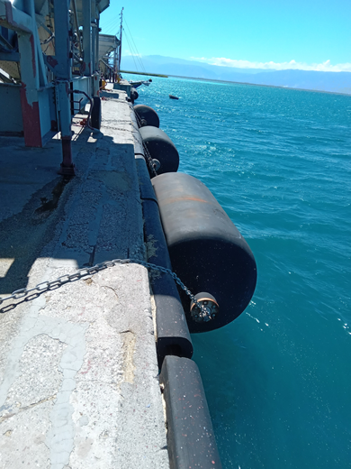
There is a single berth oriented to NW /SE. It is exposed to both prevailing Easterlies and Westerly seabreezes. The dock has excellent fenders. The port is well equipped for handling loose bulk grain and is not suitable for other cargo operations due to the dock machinery in place. There are ships approximately once every 2 months.
|
Type of Berth |
# |
Length (m) |
Height of berth from sea level |
Maximum Draft (m) |
Comments |
|---|---|---|---|---|---|
|
Conventional Berth |
1 |
170m |
2.7m |
Reported to be 10m |
Good fenders and bollards in place |
|
Roro Berth |
0 |
|
|
|
|
|
Container Berth |
0 |
|
|
|
|
|
Silo Berth |
1 |
170 |
2.7m |
Reported to be 10m |
The conventional/silo berth are the same berth |
|
Berthing Tugs |
0 |
|
|
|
|
|
Water Barges |
0 |
|
|
|
|
Port Handling Equipment
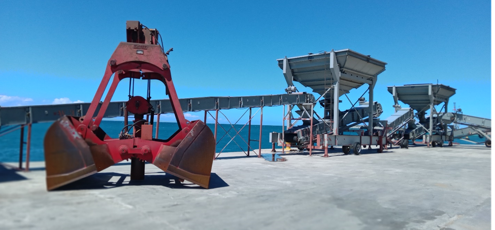
There is extensive cargo handling equipment for bulk grain. Ships are discharged using grabs into hoppers. Conveyors connect hoppers to various silos. There is a weighbridge at the port entrance.
|
Equipment |
Available |
Total Quantity and Capacity Available |
Comments on Current Condition and Actual Usage |
|---|---|---|---|
|
Grabs |
Yes |
3 |
|
|
Hoppers |
Yes |
4 |
|
|
Bagging machines |
Yes |
|
|
|
Bobcats |
Yes |
2 |
|
|
Forklifts |
Yes |
various |
In warehouses |
|
Grain Elevator with Bagging Machines |
Yes |
4 for flour |
2 for other grains |
|
Transtainer |
No |
|
|
Storage Facilities
There is a large well-maintained warehouse facility, located just outside the port. It is a substantial cement building with a tin roof. It has a smooth cement floor and good natural light and ventilation. Solid steel double sliding doors. Doors with hard stands and sheltered eaves are on 3 sides. The compound is fenced and guarded.
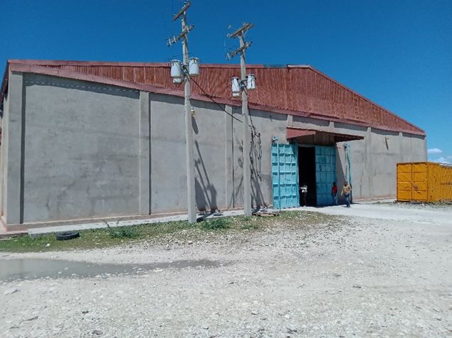
Dimensions
Length: 213m.
Width: 120m
Middle height: 10,6m
Side Height: 7,2m
Monthly rental is USD15,000.
There are numerous vertical silos in the port compound with a capacity 51000 MT of wheat. There is a large flat silo adjacent to the dock.
Security
The port has 24/7 security guards on duty. The uniformed guards were attentive both at the gate and inside the facility.
The port is surrounded by a 2.5m high wire fence topped with coiled barbed wire. There is one entrance though a sliding steel gate.
The port has its own powerplant and water treatment plant. Power and water are supplied to the neighbouring village.
Port Access
There is good access to the port. The local village is supported by mill and many locals are employed in the port.
2.1.1a Haiti Port of Terminal Varreux
Port Overview
Key port information may also be found at: http://www.maritime-database.com
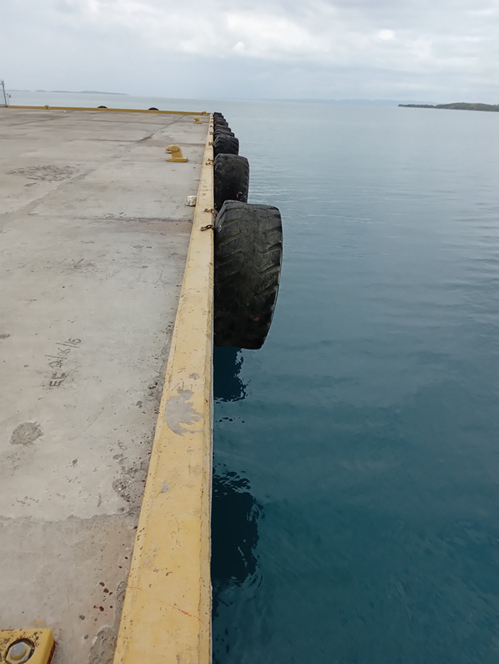
Incorporating both Terminal Varreux and Terminal Varreux Bolloré (TVB). This private port includes a bulk fuel terminal and a general cargo port. The infrastructure has been built for a container terminal, but it is not yet fully operational (July 2022)
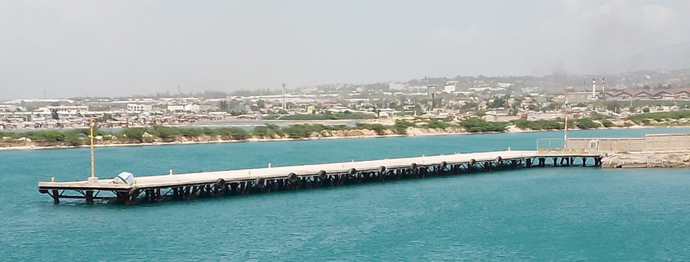
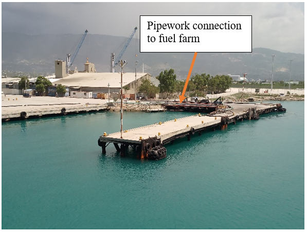
Terminal Varreux is an important port for import of petrochemicals and gas. Vegetable oil tankers also discharge here. There is a large tank farm (50million gallon capacity) within the compound connected by pipes to the tanker berth. Tankers take precedence in the port and other berthing arrangements are made around whether there is a tanker in port of expected. Bulk cement and grain are discharged into trucks using ship’s own gear. Cabotage vessels also load break bulk cargos in this port.
In 2021, the port had the following international calls: 101 tankers and 53 bulk carriers for a total of 1,700,000 MT of cargo.
The port is quite exposed and often wind affected making it difficult to manoeuvre within the port. The entrance channel is clearly marked, and vessels can enter at night. There is little tidal variation, but the port may suffer ‘wind heap’ and storm surges. The port area is low-lying and becomes very muddy during the rainy season. Terminal Varreux is adjacent to Cite de Soleil, a neighbourhood which experiences frequent gang-related violence. (July 2022)

|
Port Location and Contact |
|
|---|---|
|
Country |
Haiti |
|
Province or District |
Ouest Department |
|
Nearest Town or City Distance from Port |
Within Port-au-Prince |
|
Port's Complete Name |
Terminal Varreux |
|
Latitude |
18.573736 |
|
Longitude |
-72.346554 |
|
Managing Company or Port Authority |
Terminal Varreux/Terminal Varreux Bollere |
|
Management Contact Person |
Director – Richard LeBrun +509 3727 5558 Security – Allen Rosier +509 3707 8016 |
|
Nearest Airport and Airlines with Frequent International Arrivals/Departures |
Toussaint Louverture Port-au-Prince International Airport |
Berthing Specifications
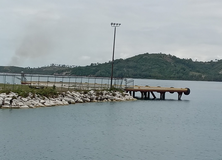
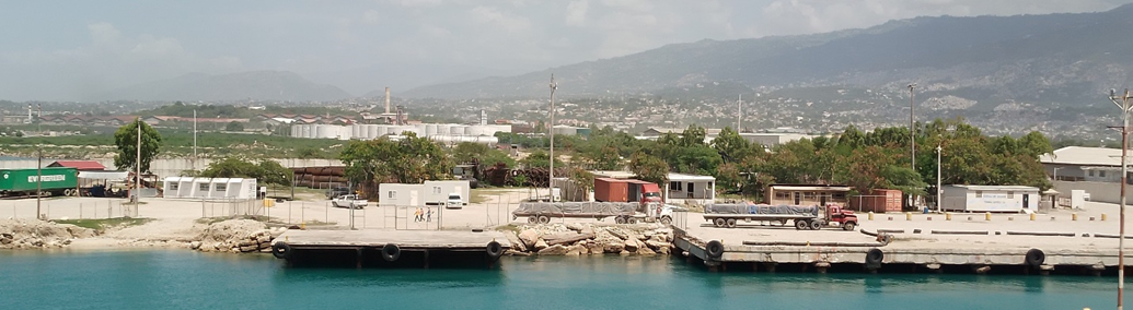
There are5 tugs available, 3 Svitzer + 2 APN. Tug service is mandatory. 1 tug for vessels up to 150m LOA, 2 tugs for vessels greater than 150m LOA. All berths have reasonable fenders and bollards. The cement structures are in good condition. The container berth #6 is currently used for occasional container movements and bulk cargoes of grain and cement.
The conventional berths #4 and #5 (pictured below) are used for break bulk and cabotage.
Berth #1 and #2 (pictured) are the tanker berths.
A section of #3(pictured below) is sometimes used for Roro vessels with stern ramps. There is no mooring buoy for securing the bow of the vessel. This wharf is 2.7m above sea level and not suitable for bow ramp vessels.
A RoRo ramp of compacted earth surrounded by cement blocks has been constructed on the Eastern shore.
|
Berth |
# |
Length |
Height above SL |
Depth |
Notes |
|---|---|---|---|---|---|
|
#1 & #2 Tanker Berth |
2 |
100m. Max vessel length 190m |
2.7 m |
10.5 m. Max vessel draft 9.5m |
Inner and outer berths. Connected to tank farm. Mooring lines block access to #3 and beach berth. Good fenders, including Yokohama fender, and bollards in place |
|
#3 Small vessel berth |
1 |
72m |
2.7 m |
8 m |
In two sections |
|
#4 & # 5 Conventional berth |
2 |
4- 120 m 5-132 m |
2.7 m |
10 m |
Break bulk |
|
#6 Container Berth |
1 |
160m. Max vessel length 210m |
2.5m |
12.5 m. Max vessel draft 12 m |
|
|
New RoRo berth |
1 |
|
1m |
8 m aft |
|
|
Beach berth |
1 |
|
6 m aft |
Subject to erosion and silting. Suitable for small vessels. Trucks may get bogged at times. |
Port Handling Equipment
Terminal Varreux had some bulk handling equipment while TVB is well equipped with a modern fleet ready for container operations. There are 4 bucket hoppers and 5 clamshells for rice, wheat, and salt.
|
Equipment |
Available |
Total Quantity and Capacity Available |
Comments on Current Condition and Actual Usage |
|---|---|---|---|
|
Mobile Cranes |
2 MHC |
Gottwald 6407 |
New |
|
Reach-stacker |
4 |
Terex 45 |
New |
|
Top-loaders |
1 |
Hyster |
New |
|
Mules |
10 |
Tug Master Ottava |
New |
|
Dedicated chassis |
12 |
40ft and 45ft |
New |
|
Forklifts |
3 |
5t |
1 new/2 used |
There is an ample stock of new cargo handling equipment in the container terminal.
Storage Facilities
There is a container yard inside the port. It is not yet in use. There is an extensive fuel tank farm (50 million gallon capacity). There is a large parking area for trucks. World Food Programme has an MSU on site. There are 2 warehouses 5500 m² and 1900 m². There is also a 30,000 MT flat silo rented to a private company.
Security
The port has 24/7 security guards on duty. The area is covered by CCTV. There are two gates to pass through along the private access road to enter the port. Security is managed by Tevassa. There is a high perimeter fence. The port complex is well lit at night and there are active security patrols. Terminal Varreux is adjacent to Cite de Soleil, a neighbourhood which experiences frequent gang-related violence. (July 2022)
Port Access
The entrance to Terminal Varruex is close to Cite de Soleil. This area is subject to frequent gang related violence. The road within the port becomes very muddy in the rainy season. At times the approach road is lined with tanker trucks waiting for a vessel to discharge.