2.3 Lesotho Road Network
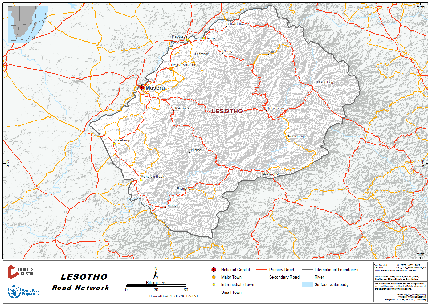
Overview
The Kingdom of Lesotho has a largely rugged topography that has made development of road and other transport network a challenge. This has a significant implication for transport modes and accessibility throughout the country. The creation of an integrated transport system remans central to the government’s infrastructure development program. The total road network in Lesotho is approximately 6906.26 kms in length of which 1798.76 kms are paved. The remainder is made up of 3830.52 km of gravel roads and 1276.98 km of earth tracks. Two agencies are responsible for management of the road network (Roads Directorate and the Ministry of Local Government (Urban and Rural)). Asset value of roads is 42 billion Maloti. Road maintenance technical needs was 2 billion Maloti (including administration, rehabilitation and maintenance) up to 2004 and has increased to 4 billion (include upgrading). Financing of maintenance is made through road fund consolidation and the GoL capital budget.
While passenger and cargo transport are provided largely by the private sector operator which includes buses, taxi and privately owned trucks, the Government provides a regulatory framework and policy to allow these industries to provide services. The Government is responsible for the Lesotho Freight and Bus Services which has been run down by inefficiency and poor management and been grounded. Due to challenging topography and infrastructure costs, some areas of the country do not have good roads network and there is no accessibility during bad weather, including rain and snow.
The Roads Directorate (RD) which is responsible for the regulatory framework and policy was established by legislation, Roads Directorate Act No. 16 of 2010 (through merging and restructuring former Roads Branch and Department of Rural Roads) to carry out road development and maintenance core functions of the road sub-sector. The changing needs of the economy and population of a country mean that strategies in any sub- sector need to be developed and regularly reviewed and updated as required. In democratic countries, the strategy review and development includes the views, knowledge and expertise of the role players in the sub-sectors.
For more information on government contact details, please see the following link: 4.1 Government Contact List.
Distance Matrix
The distances given below are from the capital city Maseru to major towns only and are over the most practicable routes; these are not necessarily the best or the fastest.
|
Travel Distance between Major Towns (km) |
||||||||||
|---|---|---|---|---|---|---|---|---|---|---|
|
Maseru |
Berea |
Leribe |
Mafeteng |
Mohale’s Hoek |
Mokhotlong |
Qacha’s Nek |
Quthing |
Thaba Tseka |
Butha Buthe |
|
|
Maseru |
58 |
96 |
77.7 |
124 |
277 |
228 |
176 |
167 |
123 |
|
|
Berea |
58 |
106 |
132 |
178 |
254 |
255 |
231 |
195 |
100 |
|
|
Leribe |
96 |
106 |
203 |
249 |
186 |
353 |
301 |
179 |
32 |
|
|
Mafeteng |
77.7 |
132 |
203 |
46.3 |
351 |
265 |
98.5 |
215 |
197 |
|
|
Mohale’s Hoek |
124 |
178 |
249 |
46.3 |
397 |
218 |
52.2 |
262 |
243 |
|
|
Mokhotlong |
277 |
254 |
186 |
351 |
397 |
|
502 |
450 |
121 |
155 |
|
Qacha’s Nek |
228 |
255 |
353 |
265 |
218 |
502 |
171 |
344 |
349 |
|
|
Quthing |
176 |
231 |
301 |
98.5 |
52.2 |
450 |
171 |
|
314 |
249 |
|
Thaba Tseka |
167 |
195 |
179 |
215 |
262 |
121 |
344 |
314 |
|
202 |
|
Butha Buthe |
123 |
100 |
32 |
197 |
243 |
155 |
249 |
249 |
202 |
|
| Distance from Capital City to Major Towns | ||
|---|---|---|
|
From |
To |
Distance (km) |
|
Maseru Circle |
Alwynskop |
167.48 |
|
Maseru Circle |
Boinyatso |
25.71 |
|
Maseru Circle |
Butha Buthe |
121.80 |
|
Maseru Circle |
Caledonspoort |
130.69 |
|
Maseru Circle |
Ficksburg Bridge |
83.97 |
|
Maseru Circle |
Ha Jonathane |
103.67 |
|
Maseru Circle |
Ha Khabo |
125.58 |
|
Maseru Circle |
Ha Koali |
41.61 |
|
Maseru Circle |
Ha Lejone |
163.51 |
|
Maseru Circle |
Ha Makhakhe |
64.37 |
|
Maseru Circle |
Ha 'Makhoroana |
79.10 |
|
Maseru Circle |
Ha 'Mamathe |
50.18 |
|
Maseru Circle |
Ha Mokhalinyane |
54.78 |
|
Maseru Circle |
Ha Mopeli |
126.20 |
|
Maseru Circle |
Ha Mosala |
68.19 |
|
Maseru Circle |
Ha Ramabanta |
65.18 |
|
Maseru Circle |
Ha Sekake |
294.14 |
|
Maseru Circle |
Ha Seshote |
194.54 |
|
Maseru Circle |
Hleoheng |
72.63 |
|
Maseru Circle |
Hlotse |
93.34 |
|
Maseru Circle |
Katse |
216.57 |
|
Maseru Circle |
Khanyane |
99.71 |
|
Maseru Circle |
Khobotle |
95.66 |
|
Maseru Circle |
Khukhune |
142.47 |
|
Maseru Circle |
Kolo |
73.95 |
|
Maseru Circle |
Lekokoaneng |
30.68 |
|
Maseru Circle |
Likalaneng |
79.65 |
|
Maseru Circle |
Likhoele |
80.91 |
|
Maseru Circle |
Mafeteng |
75.72 |
|
Maseru Circle |
Mahobong |
109.97 |
|
Maseru Circle |
Makhaleng Bridge |
130.14 |
|
Maseru Circle |
Makhunoane |
151.30 |
|
Maseru Circle |
'Mants'Ebo |
24.23 |
|
Maseru Circle |
Mants'Onyane |
120.11 |
|
Maseru Circle |
Mapholaneng |
253.97 |
|
Maseru Circle |
Mapoteng |
69.82 |
|
Maseru Circle |
Maputsoe |
83.25 |
|
Maseru Circle |
Marakabei |
103.05 |
|
Maseru Circle |
Maseru Bridge |
4.16 |
|
Maseru Circle |
Matelile |
70.14 |
|
Travel Time from Capital City to Major Towns (Hours) |
||||||||||
|---|---|---|---|---|---|---|---|---|---|---|
|
Maseru |
Berea |
Leribe |
Mafeteng |
Mohale’s Hoek |
Mokhotlong |
Qacha’s Nek |
Quthing |
Thaba Tseka |
Butha Buthe |
|
|
Maseru |
1:24 |
1:50 |
1:20 |
1:56 |
5:03 |
3:52 |
2:45 |
3:10 |
2:17 |
|
|
Berea |
1:24 |
1:26 |
2:40 |
3:16 |
4:37 |
4:54 |
4:05 |
4:12 |
1:52 |
|
|
Leribe |
1:50 |
1:26 |
3:05 |
3:41 |
3:13 |
5:35 |
4:31 |
4:04 |
0:28 |
|
|
Mafeteng |
1:20 |
2:40 |
3:05 |
0:36 |
6:23 |
4:07 |
1:25 |
3:40 |
3:37 |
|
|
Mohale’s Hoek |
1:56 |
3:16 |
3:41 |
0:36 |
6:56 |
3:32 |
0:49 |
4:17 |
4:11 |
|
|
Mokhotlong |
5:03 |
4:37 |
3:13 |
6:23 |
6:56 |
8:47 |
7:39 |
2:59 |
2:45 |
|
|
Qacha’s Nek |
3:52 |
4:54 |
5:35 |
4:07 |
3:32 |
8:47 |
2:52 |
5:54 |
6:01 |
|
|
Quthing |
2:45 |
4:05 |
4:31 |
1:25 |
0:49 |
7:39 |
2:52 |
|
5:06 |
|
|
Thaba Tseka |
3:10 |
4:12 |
4:04 |
3:40 |
4:17 |
2:59 |
5:54 |
5:06 |
|
4:31 |
|
Butha Buthe |
2:17 |
1:52 |
0:28 |
3:37 |
4:11 |
2:25 |
6:01 |
5:03 |
4:31 |
|
Road Security
In general, most roads within Lesotho are secure and transporters operate with few, if any, difficulties. There are no alarming cases of highway banditry and insecurity. Police patrols are visible and consistent along the main highways that link the main districts.
Driving is one of the biggest risks to personal safety and security. Vehicles traffic circulates on the left (keep left). Many vehicles are not roadworthy, and not all drivers are properly trained. The average speed limit in the cities is 50 km/hr and outside the city speed limit is 80 km/hr. However, most vehicle do not keep the speed limit. It is common to come up behind a vehicle moving at slower speed. Over speeding is also very common as the country traffic police do not have speed guns.
Other challenging factors include poorly lit roadways. Very few road signs on most of the highways. While many roads are in poor state of disrepair, inexperience and irresponsible drivers are also a great risk. All drivers should be aware of potholes and careless pedestrians, the presence of non-roadworthy vehicles plying the roads. The drivers frequently change the lanes into oncoming traffic without adequate viewing and caution. Street and traffic lights are frequently non-functional or nonexistence altogether.
The overall mission of the Ministry Transport and Communication is to formulate and monitor the implementation of appropriate, comprehensive and robust transport and construction sectors and maintain a dynamic and effective institutional and legal framework, which, provides an enabling environment for sustainable development of transport and construction industries and thus contribute to the achievement of the overall national development objectives.
Weighbridges and Axle Load Limits
The Ministry of Transport and Communication is yet to enact the Weighbridge and Axle Legislation. Since the neighbouring South Africa has Weighbridge legislation, most heavy vehicle in Lesotho Country will keep the maximum weigh applicable in South Africa. However this appears to have an impact on the Lesotho roads which are of lower capacity.
Source: https://lesothotradeportal.org.ls/kcfinder/upload/files/-%20Schedule%20No%201%20Part%203E.pdf
|
Axle Load Limits |
Lesotho |
South Africa |
|---|---|---|
|
Truck with 2 Axles |
18,000 Kg |
18,000 Kg |
|
Truck with 3 Axles |
24,000 Kg |
24,000 Kg |
|
Truck with 4 Axles |
TBA |
TBA |
|
Semi-trailer with 3 Axles |
TBA |
TBA |
|
Semi-trailer with 4 Axles |
TBA |
TBA |
|
Semi-trailer with 5 Axles |
TBA |
TBA |
|
Semi-trailer with 6 Axles |
TBA |
TBA |
|
Truck & Drawbar Trailer with 4 Axles |
TBA |
TBA |
|
Truck & Drawbar Trailer with 5 Axles |
TBA |
TBA |
|
Truck & Drawbar Trailer with 6 Axles |
TBA |
TBA |
|
Truck & Drawbar Trailer with 7 Axles |
TBA |
TBA |
Road Reserve and Building Restriction Areas
To protect the investment in road building, a road reserve and, outside urban areas, a building restriction area should be located equally about the road centre-line, as shown in the table below
|
Road Classification |
Width Each Side of Road Centre Line (m) |
|
|---|---|---|
|
Road Reserve (m) |
Building Restriction Width (m) |
|
|
A |
15 |
30 |
|
B (major – links districts) |
15 |
30 |
|
B (minor – links local centres to A Class Roads) |
10 |
20 |
|
C |
10 |
20 |
|
D |
10 |
20 |
Note: The building restriction width includes the road reserve width.
|
Class |
Km |
% of network |
Description |
|---|---|---|---|
|
Classified Network & Gazetted |
|||
|
A |
1525.21 |
22 |
Primary roads linking major towns and district centres and main border posts |
|
B |
1401.24 |
20 |
Secondary roads connecting districts and linking local centres to the primary network |
|
C |
539.93 |
8 |
Tertiary roads connecting local centres within districts, and linking to secondary or primary roads |
|
D |
2421.14 |
35 |
Access/Feeder roads to one or more villages |
|
Sub-Total |
5887.52 |
85 |
Total km that are in the current road Classification |
|
Unclassified Network & Not Gazetted |
|||
|
Rural Roads |
651.70 |
10 |
Access/Feeder roads to one or more villages |
|
Urban Roads |
367.04 |
5 |
Estimated paved and unpaved roads in urban areas. Streets within major towns |
|
Sub-Total |
1018.74 |
15 |
Total km that are in the current road classified |
|
Total |
6,906.26 |
100 |
Density is 0.243 km/km2. Per capita is 0.00338 km/person |
Of the total road network; the classified network is under the direct management of the Roads Directorate and is disbursed as follows per surface type:
|
Description |
Equipment-based maintenance |
Labour-based maintenance |
Total Km |
|---|---|---|---|
|
Surfaced roads |
1628.79 |
0 |
1628.79 |
|
Gravel roads |
888.98 |
2111.89 |
3000.87 |
|
Earth roads |
0 |
1150.70 |
1150.70 |
|
Tracks |
0 |
107.16 |
107.16 |
|
Totals |
2517.77 |
3369.75 |
5887.52 |
|
DESCRIPTION |
RURAL ROADS (KM) |
|---|---|
|
Surfaced roads |
0.00 |
|
Gravel roads |
615.02 |
|
Earth roads |
36.68 |
|
Tracks |
0.00 |
|
Total |
651.70 |
|
DESCRIPTION |
URBAN ROADS (KM) |
|---|---|
|
Paved roads |
169.97 |
|
Gravel roads |
214.63 |
|
Earth roads |
50.74 |
|
Tracks |
84.7 |
|
Total |
367.04 |
2.3.1 Lesotho Land Border Crossing of Maseru Bridge
Overview
This is the most active border post that is easily accessed.
|
Border Crossing Location and Contact |
|
|---|---|
|
Name of Border Crossing |
Lesotho: Maseru Bridge South Africa: Maseru Bridge |
|
Province or District |
Maseru |
|
Nearest Town or City with Distance from Border Crossing |
Maseru (4.12 km) Ladybrand (11.6 km) |
|
Latitude |
-29.299149 |
|
Longitude |
27.456379 |
|
Managing Authority / Agency |
Lesotho Revenue Authority |
|
Contact Details |
+ 266 22312204 |
|
Travel Times |
||
|---|---|---|
|
Nearest International Airport |
Moshoeshoe 1 International Airport (25.6 km) Truck Travel Time: 1 hr Car Travel time: 45 mins |
|
|
Nearest Port |
Durban Port, South Africa (552 km) Truck Travel Time: 9 hrs Car Travel time: 6 Hours 30 mins |
|
|
Nearest location with functioning wholesale markets, or with significant manufacturing or production capacity |
Maseru (4.12 km) Truck Travel Time: 30 mins Car Travel time: 15 mins |
|
|
Other Information |
Weighing bridge is by the bridge. Maseru branch line railway also crosses here. |
|
| Hours of Operation | |
|---|---|
|
Mondays |
24 hrs |
|
Tuesdays |
24 hrs |
|
Wednesdays |
24 hrs |
|
Thursdays |
24 hrs |
|
Fridays |
24 hrs |
|
Saturdays |
24 hrs |
|
Sundays |
24 hrs |
|
National Holidays |
24 hrs |
|
Seasonal Constraints |
N/A |
Daily Capacity
Traffic is normally heavy during month end, there is one lane coming into Lesotho, but amidst coronavirus regulations there is simple movement for trucks as there are limited number of private cars. The management of Maseru bridge has tried to separate the private and trucks lanes, but it is not much. However, trucks takes their toll gate where there is weighing bridge.
Customs Clearance
In order to be cleared at Maseru bridge, note that An original tax invoice should have the following normal/ usual requirements of a valid Tax invoice:
- Be a Tax Invoice from a VAT registered South African vendor
- Be a Tax Invoice (Tax Invoice written)
- Be an original
- Bear a South African VAT Registration number with 10 digits that start with 4
- Have a unique invoice number
- Tax invoice date
- Standard rate of VAT charge must be shown (e.g. 14%)
- Tax invoice is valid for 90 days from the date of purchase.
For more information on customs in Mozambique, please see the following link: 1.3 Customs Information.
Other Relevant Information
For more information on government contact details, please see the following link: 4.1 Government Contact List.
2.3.2 Lesotho Land Border Crossing of Peka Bridge
Overview
|
Border Crossing Location and Contact |
|
|---|---|
|
Name of Border Crossing |
Lesotho: Peka Bridge South Africa: Peka Bridge |
|
Province or District |
Leribe |
|
Nearest Town or City with Distance from Border Crossing |
Lesotho: Peka (6.2 km) South Africa: Ficksburg (22 km) |
|
Latitude |
-28.946753 |
|
Longitude |
27.735308 |
|
Managing Authority / Agency |
Lesotho Revenue Authority |
|
Contact Details |
+266 2232 4452 |
|
Travel Times |
||
|---|---|---|
|
Nearest International Airport |
Moshoeshoe 1 International Airport (92.8 km) Car Travel time: 1 Hour 30 mins |
|
|
Nearest Port |
Durban Port, South Africa (494 km) Car Travel time: 5 Hours 30 mins |
|
|
Nearest location with functioning wholesale markets, or with significant manufacturing or production capacity |
Peka (6.2 km) |
|
|
Other Information |
N/A |
|
| Operation | |
|---|---|
|
Mondays |
24 hrs |
|
Tuesdays |
24 hrs |
|
Wednesdays |
24 hrs |
|
Thursdays |
24 hrs |
|
Fridays |
24 hrs |
|
Saturdays |
24 hrs |
|
Sundays |
24 hrs |
|
National Holidays |
24 hrs |
|
Seasonal Constraints |
N/A |
Daily Capacity
This is a small border post with little capacity.
Customs Clearance
For more information on customs in Lesotho, please see the following link: 1.3 Customs Information
Other Relevant Information
For more information on government contact details, please see the following link: 4.1 Government Contact List
2.3.3 Lesotho Land Border Crossing of Maputsoe Bridge
Overview
This is a very active border crossing between Lesotho and South Africa and is open 24 hours.
|
Border Crossing Location and Contact |
|
|---|---|
|
Name of Border Crossing |
Lesotho: Maputsoe Bridge South Africa: Ficksburg Bridge |
|
Province or District |
Leribe |
|
Nearest Town or City with Distance from Border Crossing |
Lesotho: Maputsoe (2.7 km) South Africa: Ficksburg (3 km) |
|
Latitude |
-28.885692 |
|
Longitude |
27.892633 |
|
Managing Authority / Agency |
Lesotho Revenue Authority |
|
Contact Person |
Ha Mathata, Lesotho +266 22 430 257 +266 22 431 175 |
|
Travel Times |
||
|---|---|---|
|
Nearest International Airport |
Moshoeshoe 1 International Airport (106.2 km) Car Travel time: 1 hour 42 mins |
|
|
Nearest Port |
Durban Port, South Africa (473 km) Car Travel time: 5 Hours 35 mins |
|
|
Nearest location with functioning wholesale markets, or with significant manufacturing or production capacity |
Maputsoe (2.7 km) Travel time: 7 mins |
|
|
Other Information |
Documents required to enter Lesotho is a valid passport, original vehicle registration papers, vehicle license papers, valid driver's license. The toll fee for entering Lesotho is determined by the weight of your vehicle. | |
| Hours of Operation | |
|---|---|
|
Mondays |
24 hrs |
|
Tuesdays |
24 hrs |
|
Wednesdays |
24 hrs |
|
Thursdays |
24 hrs |
|
Fridays |
24 hrs |
|
Saturdays |
24 hrs |
|
Sundays |
24 hrs |
|
National Holidays |
24 hrs |
|
Seasonal Constraints |
N/A |
Daily Capacity
This is a small border post with little capacity.
Customs Clearance
In order to be cleared at Maputsoe Bridge, note that an original tax invoice should have the following normal/ usual requirements of a valid tax invoice:
- Be a Tax Invoice from a VAT registered South African vendor
- Be a Tax Invoice (Tax Invoice written)
- Be an original
- Bear a South African VAT Registration number with 10 digits that start with 4
- Have a unique invoice number
- Tax invoice date
- Standard rate of VAT charge must be shown (e.g. 14%)
- Tax invoice is valid for 90 days from the date of purchase.
Vehicles crossing Tariffs
|
Vehicle Classes |
Local Registered |
Foreign Registered |
|---|---|---|
|
Class 1 - Light vehicle |
M50 |
M70 |
|
Class 2 - Medium Heavy |
M90 |
M120 |
|
Class 3 - Large Heavy |
M130 |
M180 |
|
Class 4 - Extra Heavy |
M310 |
M410 |
For more information on customs in Mozambique, please see the following link: 1.3 Customs Information
Other Relevant Information
For more information on government contact details, please see the following link: 4.1 Government Contact List
2.3.4 Lesotho Land Border Crossing of Caledonspoort Bridge
Overview
The Caledonspoort Border Control Post manages access in to and out of Lesotho. This route can get very busy, particularly on Friday and Sunday afternoons.
|
Border Crossing Location and Contact |
|
|---|---|
|
Name of Border Crossing |
Lesotho: Caledonspoort Bridge South Africa: Caledonspoort Bridge |
|
Province or District |
Butha-Buthe |
|
Nearest Town or City with Distance from Border Crossing |
Lesotho: Butha-Buthe (9 km) South Africa: Fouriesburg (10 km) |
|
Latitude |
-28.696335 |
|
Longitude |
28.234843 |
|
Managing Authority / Agency |
Lesotho Revenue Authority |
|
Contact Details |
+ 266 2232 4452 |
|
Travel Times |
||
|---|---|---|
|
Nearest International Airport |
Moshoeshoe 1 International Airport (106.4 km) Car Travel time: 2 hrs 25 mins |
|
|
Nearest Port |
Durban Port, South Africa (433 km) Car Travel time: 5 hrs |
|
|
Nearest location with functioning wholesale markets, or with significant manufacturing or production capacity |
Butha-Buthe (9 km) Car Travel time: 11 mins |
|
|
Other Information |
The road surface is good for the most part, but there are bad sections in which worn tar becomes a gravel road. | |
| Hours of Operation | |
|---|---|
|
Mondays |
0600 - 2200 H |
|
Tuesdays |
0600 - 2200 H |
|
Wednesdays |
0600 - 2200 H |
|
Thursdays |
0600 - 2200 H |
|
Fridays |
0600 - 2200 H |
|
Saturdays |
0600 - 2200 H |
|
Sundays |
0600 - 2200 H |
|
National Holidays |
0600 - 2200 H |
|
Seasonal Constraints |
N/A |
Daily Capacity
This is a small border post with little capacity.
Customs Clearance
In order to be cleared at Caledonspoort Bridge, note that an original tax invoice should have the following normal/ usual requirements of a valid tax invoice:
- Be a Tax Invoice from a VAT registered South African vendor
- Be a Tax Invoice (Tax Invoice written)
- Be an original
- Bear a South African VAT Registration number with 10 digits that start with 4
- Have a unique invoice number
- Tax invoice date
- Standard rate of VAT charge must be shown (e.g. 14%)
- Tax invoice is valid for 90 days from the date of purchase.
Vehicles crossing Tariffs
|
Vehicle Classes |
Local Registered |
Foreign Registered |
|---|---|---|
|
Class 1 - Light vehicle |
M50 |
M70 |
|
Class 2 - Medium Heavy |
M90 |
M120 |
|
Class 3 - Large Heavy |
M130 |
M180 |
|
Class 4 - Extra Heavy |
M310 |
M410 |
For more information on customs in Lesotho, please see the following link: 1.3 Customs Information
Other Relevant Information
For more information on government contact details, please see the following link: 4.1 Government Contact List
2.3.5 Lesotho Land Border Crossing of Monantsa Pass
Overview
This border post between South Africa and Lesotho is not very busy. On the South African side there is a border post, the Monantsa Pass Border control, but there is no border control point on the Lesotho side of the border.
|
Border Crossing Location and Contact |
|
|---|---|
|
Name of Border Crossing |
South Africa: Monantsa Pass |
|
Province or District |
Butha-Buthe |
|
Nearest Town or City with Distance from Border Crossing |
Lesotho: Libono (11.2 km) South Africa: Phuthaditjhaba (16.5 km) |
|
Latitude |
-28.6826 |
|
Longitude |
28.5902 |
|
Managing Authority / Agency |
South African Revenue Service |
|
Contact Details |
+27(0)58 713 1600 +27(0)58 713 5843 |
|
Travel Times |
||
|---|---|---|
|
Nearest International Airport |
Moshoeshoe 1 International Airport (235.9 km) Travel time: 3 hrs 33 mins |
|
|
Nearest Port |
Durban Port, South Africa (366 km) Travel time: 4 hrs 23 mins |
|
|
Nearest location with functioning wholesale markets, or with significant manufacturing or production capacity |
Phuthaditjhaba (16.5 km) Travel time: 30 mins |
|
|
Other Information |
N/A | |
| Hours of Operation | |
|---|---|
|
Mondays |
8:00 – 16:00 |
|
Tuesdays |
8:00 – 16:00 |
|
Wednesdays |
8:00 – 16:00 |
|
Thursdays |
8:00 – 16:00 |
|
Fridays |
8:00 – 16:00 |
|
Saturdays |
8:00 – 16:00 |
|
Sundays |
8:00 – 16:00 |
|
National Holidays |
8:00 – 16:00 |
|
Seasonal Constraints |
N/A |
Daily Capacity
This is a small border post with little capacity.
Customs Clearance
In order to be cleared at Monantsa Pass, note that an original tax invoice should have the following normal/ usual requirements of a valid tax invoice:
- Be a Tax Invoice from a VAT registered South African vendor
- Be a Tax Invoice (Tax Invoice written)
- Be an original
- Bear a South African VAT Registration number with 10 digits that start with 4
- Have a unique invoice number
- Tax invoice date
- Standard rate of VAT charge must be shown (e.g. 14%)
- Tax invoice is valid for 90 days from the date of purchase.
Vehicles crossing Tariffs
|
Vehicle Classes |
Local Registered |
Foreign Registered |
|---|---|---|
|
Class 1 - Light vehicle |
M50 |
M70 |
|
Class 2 - Medium Heavy |
M90 |
M120 |
|
Class 3 - Large Heavy |
M130 |
M180 |
|
Class 4 - Extra Heavy |
M310 |
M410 |
For more information on customs in Lesotho, please see the following link: 1.3 Customs Information
Other Relevant Information
For more information on government contact details, please see the following link: 4.1 Government Contact List.
2.3.6 Lesotho Land Border Crossing of Sani Pass
Overview
The Sani Pass border post is at the bottom of the pass, and the RSA border post is about 8 km further apart. The gravel roads are in fair condition and are often only accessible by 4x4 vehicles beyond the border post.
|
Border Crossing Location and Contact |
|
|---|---|
|
Name of Border Crossing |
Lesotho: Sani Top / Pass South Africa: Sani Top / Pass |
|
Province or District |
Mokhotlong |
|
Nearest Town or City with Distance from Border Crossing |
Lesotho: Mokhotlong (50 km) South Africa: Himeville (32 km) |
|
Latitude |
-29.584695 |
|
Longitude |
29.285566 |
|
Managing Authority / Agency |
Lesotho Revenue Authority |
|
Contact |
+27 826395050 |
|
Travel Times |
||
|---|---|---|
|
Nearest International Airport |
Moshoeshoe 1 International Airport (350.1 km) Travel time: 6 hrs |
|
|
Nearest Port |
Durban Port, South Africa (272 km) Travel time: 4 hrs |
|
|
Nearest location with functioning wholesale markets, or with significant manufacturing or production capacity |
Himeville (32 km) |
|
|
Other Information |
Four wheel drive vehicles and motorcycles are better suited for the road. Driving Sani Pass very much depend on current weather and road conditions. During the rains (October to March), the road can be very badly washed away, muddy and driving up Sani Pass in these conditions, can be pretty challenging. A vehicle with good ground clearance, and four wheel drive, is required. In wintertime, with no rain, the road conditions should be better, but Sani Pass also gets some snow in winter which leads to muddy conditions when the snow melts. If the road was not repaired after the rain, you will still encounter some bad ruts. |
|
| Hours of Operation | |
|---|---|
|
Mondays |
0600H - 1800H |
|
Tuesdays |
0600H - 1800H |
|
Wednesdays |
0600H - 1800H |
|
Thursdays |
0600H - 1800H |
|
Fridays |
0600H - 1800H |
|
Saturdays |
0600H - 1800H |
|
Sundays |
0600H - 1800H |
|
National Holidays |
0600H - 1800H |
|
Seasonal Constraints |
N/A |
Daily Capacity
This is a small border post with little capacity.
Customs Clearance
In order to be cleared at Sani Pass, note that an original tax invoice should have the following normal/ usual requirements of a valid tax invoice:
- Be a Tax Invoice from a VAT registered South African vendor
- Be a Tax Invoice (Tax Invoice written)
- Be an original
- Bear a South African VAT Registration number with 10 digits that start with 4
- Have a unique invoice number
- Tax invoice date
- Standard rate of VAT charge must be shown (e.g. 14%)
- Tax invoice is valid for 90 days from the date of purchase.
Vehicles crossing Tariffs
|
Vehicle Classes |
Local Registered |
Foreign Registered |
|---|---|---|
|
Class 1 - Light vehicle |
M50 |
M70 |
|
Class 2 - Medium Heavy |
M90 |
M120 |
|
Class 3 - Large Heavy |
M130 |
M180 |
|
Class 4 - Extra Heavy |
M310 |
M410 |
For more information on customs in Lesotho, please see the following link: 1.3 Customs Information
Other Relevant Information
For more information on government contact details, please see the following link: 4.1 Government Contact List.
2.3.7 Lesotho Land Border Crossing of Ngoangoana
Overview
This border post is currently closed to all vehicle traffic between the two countries at this stage. Only pedestrians and motorbikes currently use it.
|
Border Crossing Location and Contact |
|
|---|---|
|
Name of Border Crossing |
Lesotho: Ngoanagoana South Africa: Boesmansnek |
|
Province or District |
Boesmansnek |
|
Nearest Town or City with Distance from Border Crossing |
Lesotho: Boesmansnek South Africa: Coleford Drakensberg (2.5km) |
|
Latitude |
29.1532 |
|
Longitude |
29.8849 |
|
Managing Authority / Agency |
Lesotho Revenue Authority |
|
Contact Details |
+266 2232 4452 |
|
Travel Times |
||
|---|---|---|
|
Nearest International Airport |
Moshoeshoe 1 International Airport |
|
|
Nearest Port |
Durban Port, South Africa |
|
|
Other Information |
Closed |
|
| Hours of Operation | |
|---|---|
|
Mondays |
Closed |
|
Tuesdays |
Closed |
|
Wednesdays |
Closed |
|
Thursdays |
Closed |
|
Fridays |
Closed |
|
Saturdays |
Closed |
|
Sundays |
Closed |
|
National Holidays |
Closed |
|
Seasonal Constraints |
N/A |
Daily Capacity
This is a small border post with little capacity.
Customs Clearance
For more information on customs in Lesotho, please see the following link: 1.3 Customs Information
Other Relevant Information
For more information on government contact details, please see the following link: 4.1 Government Contact List
2.3.8 Lesotho Land Border Crossing of Ramats’eliso Gate
Overview
This is a small border post that is easily accessed due to paved roads However, there is not much traffic between the two countries at this stage. It is one of five automated commercial land border posts in Lesotho. Pre-clearance of goods through the ASYCUDA system is encouraged for prompt clearing of goods into Lesotho.
|
Border Crossing Location and Contact |
|
|---|---|
|
Name of Border Crossing |
Lesotho: Ramats’eliso Gate South Africa: Ramats’eliso Gate |
|
Province or District |
Mokhotlong |
|
Nearest Town or City with Distance from Border Crossing |
Lesotho: Ramats’eliso Gate (1 km) South Africa: Maluti, Matatiele (38 km) |
|
Latitude |
-30.050231 |
|
Longitude |
28.933673 |
|
Managing Authority / Agency |
Lesotho Revenue Authority |
|
Contact Person |
+27 39 256 4443 +27823468945 |
|
Travel Times |
||
|---|---|---|
|
Nearest International Airport |
Moshoeshoe 1 International Airport (266 km) Travel time: 5 hrs |
|
|
Nearest Port |
Durban Port, South Africa (312 km) Travel time: 4 hrs 51 mins |
|
|
Nearest location with functioning wholesale markets, or with significant manufacturing or production capacity |
Maluti, Matatiele (38 km) Travel time: 40 mins |
|
|
Other Information |
Closed |
|
| Hours of Operation | |
|---|---|
|
Mondays |
Closed |
|
Tuesdays |
Closed |
|
Wednesdays |
Closed |
|
Thursdays |
Closed |
|
Fridays |
Closed |
|
Saturdays |
Closed |
|
Sundays |
Closed |
|
National Holidays |
Closed |
|
Seasonal Constraints |
N/A |
Daily Capacity
This is a small border post with little capacity.
Customs Clearance
In order to be cleared at Sani Pass, note that an original tax invoice should have the following normal/ usual requirements of a valid tax invoice:
- Be a Tax Invoice from a VAT registered South African vendor
- Be a Tax Invoice (Tax Invoice written)
- Be an original
- Bear a South African VAT Registration number with 10 digits that start with 4
- Have a unique invoice number
- Tax invoice date
- Standard rate of VAT charge must be shown (e.g. 14%)
- Tax invoice is valid for 90 days from the date of purchase.
Vehicles crossing Tariffs
|
Vehicle Classes |
Local Registered |
Foreign Registered |
|---|---|---|
|
Class 1 - Light vehicle |
M50 |
M70 |
|
Class 2 - Medium Heavy |
M90 |
M120 |
|
Class 3 - Large Heavy |
M130 |
M180 |
|
Class 4 - Extra Heavy |
M310 |
M410 |
For more information on customs in Lesotho, please see the following link: 1.3 Customs Information
Other Relevant Information
For more information on government contact details, please see the following link: 4.1 Government Contact List
2.3.9 Lesotho Land Border Crossing of Qacha's Nek
Overview
This is a small border post that is easily accessed due to paved roads However, there is not much traffic between the two countries at this stage.
|
Border Crossing Location and Contact |
|
|---|---|
|
Name of Border Crossing |
Lesotho: Qacha’s Nek South Africa: Qacha’s Nek |
|
Province or District |
Qacha’s Nek |
|
Nearest Town or City with Distance from Border Crossing |
Lesotho: Qacha’s Nek (2 km) South Africa: Maluti (17.9 km) |
|
Latitude |
-30.129335 |
|
Longitude |
28.685536 |
|
Managing Authority / Agency |
Lesotho Revenue Authority |
|
Contact Person |
+266 22950290 |
|
Travel Times |
||
|---|---|---|
|
Nearest International Airport |
Moshoeshoe 1 International Airport (219 km) Travel time: 3 hrs 43 mins |
|
|
Nearest Port |
Durban Port, South Africa (353 km) Travel time: 4 hrs 58 mins |
|
|
Nearest location with functioning wholesale markets, or with significant manufacturing or production capacity |
Maluti (17.9 km) Travel time: 25 mins |
|
|
Other Information |
N/A | |
| Hours of Operation | |
|---|---|
|
Mondays |
08:00-22:00 |
|
Tuesdays |
08:00-22:00 |
|
Wednesdays |
08:00-22:00 |
|
Thursdays |
08:00-22:00 |
|
Fridays |
08:00-22:00 |
|
Saturdays |
08:00-22:00 |
|
Sundays |
08:00-22:00 |
|
National Holidays |
08:00-22:00 |
|
Seasonal Constraints |
N/A |
Daily Capacity
This is a small border post with little capacity.
Customs Clearance
In order to be cleared at Qacha's Nek, note that an original tax invoice should have the following normal/ usual requirements of a valid tax invoice:
- Be a Tax Invoice from a VAT registered South African vendor
- Be a Tax Invoice (Tax Invoice written)
- Be an original
- Bear a South African VAT Registration number with 10 digits that start with 4
- Have a unique invoice number
- Tax invoice date
- Standard rate of VAT charge must be shown (e.g. 14%)
- Tax invoice is valid for 90 days from the date of purchase.
Vehicles crossing Tariffs
|
Vehicle Classes |
Local Registered |
Foreign Registered |
|---|---|---|
|
Class 1 - Light vehicle |
M50 |
M70 |
|
Class 2 - Medium Heavy |
M90 |
M120 |
|
Class 3 - Large Heavy |
M130 |
M180 |
|
Class 4 - Extra Heavy |
M310 |
M410 |
For more information on customs in Lesotho, please see the following link: 1.3 Customs Information
Other Relevant Information
For more information on government contact details, please see the following link: 4.1 Government Contact List
2.3.10 Lesotho Land Border Crossing of Ongeluksnek
Overview
There is currently no border control point here for Lesotho only a border control point further on for RSA. Vehicles rarely drive through here. When entering Lesotho from Ongeluksnek, travellers are only stamped out from South Africa and not stamped into Lesotho and vice versa when travelling in the other direction.
|
Border Crossing Location and Contact |
|
|---|---|
|
Name of Border Crossing |
Lesotho: Ongeluksnek South Africa: Ongeluksnek |
|
Province or District |
Quthing |
|
Nearest Town or City with Distance from Border Crossing |
Lesotho: Mphaki (40 km) South Africa: Mariazell Mission (13 km) |
|
Latitude |
28.2519 |
|
Longitude |
30.3383 |
|
Managing Authority / Agency |
Lesotho Revenue Authority |
|
Contact Person |
+266 2232 4452 |
|
Travel Times |
||
|---|---|---|
|
Nearest International Airport |
Moshoeshoe 1 International Airport (222.2 km) Travel time: 4 hrs 10 mins |
|
|
Nearest Port |
Durban Port, South Africa (380 km) Travel time: 5 hrs 10 mins |
|
|
Nearest location with functioning wholesale markets, or with significant manufacturing or production capacity |
Mariazell Mission (13 km) Travel time: 27 mins |
|
|
Other Information |
Four wheel drive vehicles and motorcycles required at this border crossing. |
|
| Hours of Operation | |
|---|---|
|
Mondays |
08:00-16:00 |
|
Tuesdays |
08:00-16:00 |
|
Wednesdays |
08:00-16:00 |
|
Thursdays |
08:00-16:00 |
|
Fridays |
08:00-16:00 |
|
Saturdays |
08:00-16:00 |
|
Sundays |
08:00-16:00 |
|
National Holidays |
08:00-16:00 |
|
Seasonal Constraints |
N/A |
Daily Capacity
This is a small border post with little capacity.
Customs Clearance
For more information on customs in Lesotho, please see the following link: 1.3 Customs Information
Other Relevant Information
For more information on government contact details, please see the following link: 4.1 Government Contact List.
2.3.11 Lesotho Land Border Crossing of Tele Bridge
Overview
This is a small border post that is poorly accessed due to the mountainous road terrain.
|
Border Crossing Location and Contact |
|
|---|---|
|
Name of Border Crossing |
Lesotho: Tele Bridge South Africa: Telle Bridge Border Post |
|
Province or District |
Quthing |
|
Nearest Town or City with Distance from Border Crossing |
Lesotho: Quthing (14 km) South Africa: Palmietfontein (3.9 km) |
|
Latitude |
-30.432488 |
|
Longitude |
27.568022 |
|
Managing Authority / Agency |
Lesotho Revenue Authority |
|
Contact |
+26658987814 |
|
Travel Times |
||
|---|---|---|
|
Nearest International Airport |
Moshoeshoe 1 International Airport (751 km) Travel time: 9 hrs 40 mins |
|
|
Nearest Port |
Durban Port, South Africa (380 km) Travel time: 5 hrs 10 mins |
|
|
Nearest location with functioning wholesale markets, or with significant manufacturing or production capacity |
Quthing (14 km) Travel time: 25 mins |
|
|
Other Information |
Four wheel drive vehicles and motorcycles required at this border crossing. |
|
| Hours of Operation | |
|---|---|
|
Mondays |
08:00-22:00 |
|
Tuesdays |
08:00-22:00 |
|
Wednesdays |
08:00-22:00 |
|
Thursdays |
08:00-22:00 |
|
Fridays |
08:00-22:00 |
|
Saturdays |
08:00-22:00 |
|
Sundays |
08:00-22:00 |
|
National Holidays |
08:00-22:00 |
|
Seasonal Constraints |
N/A |
Daily Capacity
This is a small border post with little capacity.
Customs Clearance
In order to be cleared at Sani Pass, note that an original tax invoice should have the following normal/ usual requirements of a valid tax invoice:
- Be a Tax Invoice from a VAT registered South African vendor
- Be a Tax Invoice (Tax Invoice written)
- Be an original
- Bear a South African VAT Registration number with 10 digits that start with 4
- Have a unique invoice number
- Tax invoice date
- Standard rate of VAT charge must be shown (e.g. 14%)
- Tax invoice is valid for 90 days from the date of purchase.
Vehicles Crossing Tariffs
|
Vehicle Classes |
Local Registered |
Foreign Registered |
|---|---|---|
|
Class 1 - Light vehicle |
M50 |
M70 |
|
Class 2 - Medium Heavy |
M90 |
M120 |
|
Class 3 - Large Heavy |
M130 |
M180 |
|
Class 4 - Extra Heavy |
M310 |
M410 |
For more information on customs in Lesotho, please see the following link: 1.3 Customs Information
Other Relevant Information
For more information on government contact details, please see the following link: 4.1 Government Contact List
2.3.12 Lesotho Land Border Crossing of Makhaleng Bridge
Overview
This is the border between Lesotho and South Africa and its on the A2 road towards Mohale's Hoek.
|
Border Crossing Location and Contact |
|
|---|---|
|
Name of Border Crossing |
Lesotho: Makhaleng Bridge South Africa: Makhaleng Bridge |
|
Province or District |
Mohale’s Hoek |
|
Nearest Town or City with Distance from Border Crossing |
Lesotho: Mohale’s Hoek (8 km) South Africa: Zastron (40 km) |
|
Latitude |
-30.165181 |
|
Longitude |
27.400337 |
|
Managing Authority / Agency |
Lesotho Revenue Authority |
|
Contact Person |
+266 2232 4452 |
|
Travel Times |
||
|---|---|---|
|
Nearest International Airport |
Moshoeshoe 1 International Airport (103.4 km) Travel time: 1 hr 27 mins |
|
|
Nearest Port |
Durban Port, South Africa (553 km) Travel time: 8 hrs 30 mins |
|
|
Nearest location with functioning wholesale markets, or with significant manufacturing or production capacity |
Mohale’s Hoek (8 km) Travel time: 10 mins |
|
|
Other Information |
N/A | |
| Hours of Operation | |
|---|---|
|
Mondays |
08:00-18:00 |
|
Tuesdays |
08:00-18:00 |
|
Wednesdays |
08:00-18:00 |
|
Thursdays |
08:00-18:00 |
|
Fridays |
08:00-18:00 |
|
Saturdays |
08:00-18:00 |
|
Sundays |
08:00-18:00 |
|
National Holidays |
08:00-18:00 |
|
Seasonal Constraints |
N/A |
Daily Capacity
This is a small border post with little capacity.
Customs Clearance
In order to be cleared at Makhaleng Bridge, note that an original tax invoice should have the following normal/ usual requirements of a valid tax invoice:
- Be a Tax Invoice from a VAT registered South African vendor
- Be a Tax Invoice (Tax Invoice written)
- Be an original
- Bear a South African VAT Registration number with 10 digits that start with 4
- Have a unique invoice number
- Tax invoice date
- Standard rate of VAT charge must be shown (e.g. 14%)
- Tax invoice is valid for 90 days from the date of purchase.
Vehicles Crossing Tariffs
|
Vehicle Classes |
Local Registered |
Foreign Registered |
|---|---|---|
|
Class 1 - Light vehicle |
M50 |
M70 |
|
Class 2 - Medium Heavy |
M90 |
M120 |
|
Class 3 - Large Heavy |
M130 |
M180 |
|
Class 4 - Extra Heavy |
M310 |
M410 |
For more information on customs in Lesotho, please see the following link: 1.3 Customs Information.
Other Relevant Information
For more information on government contact details, please see the following link: 4.1 Government Contact List.
2.3.13 Lesotho Land Border Crossing of Sephapus Gate
Overview
This is an active border post between South Africa and Lesotho with the South African town of Wepener on the other side of the border.
|
Border Crossing Location and Contact |
|
|---|---|
|
Name of Border Crossing |
Lesotho: Sepaphus Gate South Africa: Sepaphus Gate |
|
Province or District |
Mohale’s Hoek |
|
Nearest Town or City with Distance from Border Crossing |
Lesotho: Mafeteng (15 km) South Africa: Vanstadensrus (28 km) |
|
Latitude |
27.1993 |
|
Longitude |
29.9476 |
|
Managing Authority / Agency |
Lesotho Revenue Authority |
|
Contact Person |
+266 2232 4452 |
|
Travel Times |
||
|---|---|---|
|
Nearest International Airport |
Moshoeshoe 1 International Airport (82.5 km) Travel time: 1 hr 25 mins |
|
|
Nearest Port |
Durban Port, South Africa (666 km) Car Travel time: 8Hrs 14mins |
|
|
Nearest location with functioning wholesale markets, or with significant manufacturing or production capacity |
Mafeteng (15 km) Travel time: 26 mins |
|
|
Other Information |
N/A | |
| Hours of Operation | |
|---|---|
|
Mondays |
08:00-16:00 |
|
Tuesdays |
08:00-16:00 |
|
Wednesdays |
08:00-16:00 |
|
Thursdays |
08:00-16:00 |
|
Fridays |
08:00-16:00 |
|
Saturdays |
08:00-16:00 |
|
Sundays |
08:00-16:00 |
|
National Holidays |
08:00-16:00 |
|
Seasonal Constraints |
N/A |
Daily Capacity
This is a small border post with little capacity.
Customs Clearance
For more information on customs in Lesotho, please see the following link: 1.3 Customs Information
Other Relevant Information
For more information on government contact details, please see the following link: 4.1 Government Contact List.
2.3.14 Lesotho Land Border Crossing of Van Rooyen's Gate
Overview
This is the border between Lesotho and South Africa and its on the A2 road towards Mohale's Hoek.
|
Border Crossing Location and Contact |
|
|---|---|
|
Name of Border Crossing |
Lesotho: Van Rooyen's Gate South Africa: Van Rooyen's Gate |
|
Province or District |
Mafeteng |
|
Nearest Town or City with Distance from Border Crossing |
Lesotho: Mafeteng (16 km) South Africa: Wepener (12 km) |
|
Latitude |
-29.756147 |
|
Longitude |
27.110988 |
|
Managing Authority / Agency |
Lesotho Revenue Authority |
|
Contact |
+266 22785329 |
|
Travel Times |
||
|---|---|---|
|
Nearest International Airport |
Moshoeshoe 1 International Airport (80.8 km) Travel time: 1 hr 11 mins |
|
|
Nearest Port |
Durban Port, South Africa (639 km) Travel time: 7 hrs 40 mins |
|
|
Nearest location with functioning wholesale markets, or with significant manufacturing or production capacity |
Mafeteng (16 km) Travel time: 20 mins |
|
|
Other Information |
N/A | |
| Hours of Operation | |
|---|---|
|
Mondays |
08:00-22:00 |
|
Tuesdays |
08:00-22:00 |
|
Wednesdays |
08:00-22:00 |
|
Thursdays |
08:00-22:00 |
|
Fridays |
08:00-22:00 |
|
Saturdays |
08:00-22:00 |
|
Sundays |
08:00-22:00 |
|
National Holidays |
08:00-22:00 |
|
Seasonal Constraints |
N/A |
Daily Capacity
This is a small border post with little capacity.
Customs Clearance
In order to be cleared at Makhaleng Bridge, note that an original tax invoice should have the following normal/ usual requirements of a valid tax invoice:
- Be a Tax Invoice from a VAT registered South African vendor
- Be a Tax Invoice (Tax Invoice written)
- Be an original
- Bear a South African VAT Registration number with 10 digits that start with 4
- Have a unique invoice number
- Tax invoice date
- Standard rate of VAT charge must be shown (e.g. 14%)
- Tax invoice is valid for 90 days from the date of purchase.
Vehicles Crossing Tariffs
|
Vehicle Classes |
Local Registered |
Foreign Registered |
|---|---|---|
|
Class 1 - Light vehicle |
M50 |
M70 |
|
Class 2 - Medium Heavy |
M90 |
M120 |
|
Class 3 - Large Heavy |
M130 |
M180 |
|
Class 4 - Extra Heavy |
M310 |
M410 |
For more information on customs in Lesotho, please see the following link: 1.3 Customs Information
Other Relevant Information
For more information on government contact details, please see the following link: 4.1 Government Contact List