2.2 Afghanistan Aviation
Overview
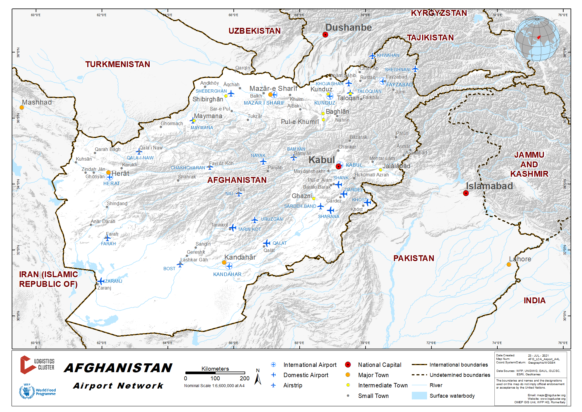
Civil Air Transport in Afghanistan is mainly used for passenger services. Afghanistan has about 50 airports/airfields, with the biggest being the Kabul International Airport, serving the capital and centre region. Main airports are Kandahar International Airport in the south, Herat International Airport in the west, and Mazar-i-Sharif International Airport in the north. Some smaller airfields have unpaved runways facilities and operate under visual flight rules.
Commercial Flights for Passenger Services
Domestic Flights
Ariana Afghan Airlines is the national airline, connecting Kabul, Kandahar, Heat and Mazar-i-Sharif. Kam Air connects to other domestic airports and Dubai.
International Flights
|
Airline |
Headquartered |
International Flights |
|---|---|---|
|
Ariana Afghan Airlines |
Afghanistan |
Kabul, Dubai, Riyadh, Jeddah, and Islamabad |
|
Kam Air |
Afghanistan |
Kabul, Islamabad, Dubai, Abu Dhabi, Shanghai, and Ankara |
|
Mahan Air |
Iran |
Kabul, Teheran and Mashad |
|
Taban Airlines |
Iran |
Kabul to Teheran Kandahar to Mashhad |
Cargo Services
All airway companies that have air operations in Kabul perform cargo shipment to and from Kabul.
Cargo Handling
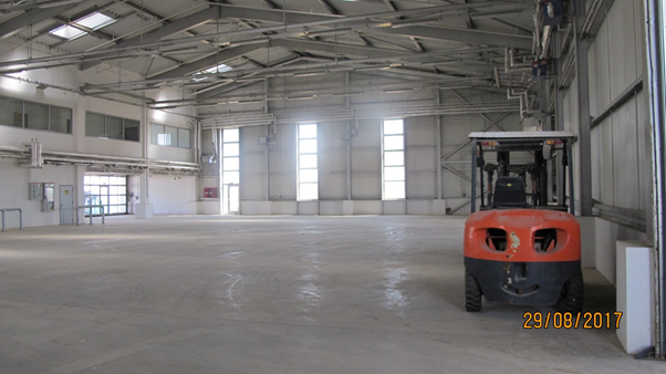
Cargo handling is performed at Kabul International Airport by GAAC.
|
GAAC Contact Information |
||
|---|---|---|
|
Website: https://gaacsolutions.com/ |
||
| Contact Person | Phone Number | Email Address |
|
John |
0093700029302 |
|
|
Irfan |
0093700029303 |
|
|
Jai |
0093700029304 |
|
|
OCC |
0093700029225 |
|
Humanitarian Flights
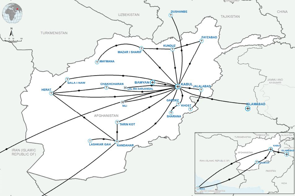
Humanitarian air transport organisations collaborate between themselves, defining destinations in consideration of fleet characteristics and airports specificities.
UNHAS
UNHAS provide passengers air transport. If requested, dedicated cargo flights can be performed.
Booking and Customer Service: +93(0)706004283
Emergency Mobile: +93(0)706004286 (24/7 coverage)
unhas-afg.customerservice@wfp.org, unhas-afg.reservation@wfp.org
Humanitarian Booking Hub: https://humanitarianbooking.wfp.org/en/countries/af/locations/30/facilities/2505/detail/?service=UNHAS+Flights
PACTEC Afghanistan
Currently not operational.
Tel: +93 (0)700282679: +93 (0)799300837
Emergency cell phone: +93(0)799020712
Humanitarian organisations need to register before requesting flights: http://www.flypactec.org/
Contacts available here: https://www.flypactec.org/contact.html
ICRC
ICRC aircrafts are exclusively dedicated to ICRC staff transportation. Fixed schedule to various destinations is implemented. If remaining capacity is available, ICRC might offer seats or cargo space to other humanitarian organizations if specifically requested. ICRC management evaluate the requests prior to giving permission.
ICRC Air Operations Manager: Olivier Misuri-Masseglia (omisurimasseglia@icrc.org)
+93729140536 / +992900013174 / +998931844818
UNAMA Flights
UNAMA is currently operating humanitarian passenger flights between Almaty and Kabul. All passengers are required to provide 10 days advance notice of their intended arrival in Almaty.
Notifications should be sent by email to:
UNAMA Passenger Booking: UNAMA-PBO@un.org
UNAMA Notification of Travel: Ms. Sabrina Naidu naidus@un.org
2.2.1 Afghanistan Kabul International Airport
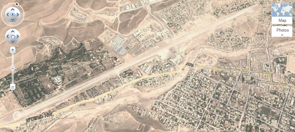
Kabul International Airport is located 5 kilometers (3.1 mi) from the city center of Kabul in Afghanistan. It serves as one of the nation's main international airports and it can house over one hundred aircraft. It was previously known locally as Khwaja Rawash Airport. The airport has been expanded and modernized in the last decade. A new international terminal was added and the older terminal is now used for domestic flights.
|
Airport Location and Contact |
|
|---|---|
|
Country |
Afghanistan |
|
Province or District |
Kabul |
|
Nearest Town or City with Distance from Airport |
Kabul |
|
Airport’s Complete Name |
Kabul International Airport |
|
Latitude |
34.565853 N |
|
Longitude |
69.212328 E |
|
Elevation |
1,790 m / 5,872 ft |
|
IATA Code |
KBL |
|
ICAO Code |
OAKB |
|
Managing Company or Airport Authority |
Military – Civil Joint Use Airport Afghan Civil Aviation Authority |
|
Management Contact Person |
|
|
Open From / To |
Kabul International Airport is open from sunrise to sunset. |


Description and Contacts of Key Companies
Afghanistan Civil Aviation Authority
The airport has two terminal buildings, the newer one for
international flights and the older Soviet built one for domestic
flights. Several hangars along the runway are for military
aircraft. There are no hangars for civilian (or transient)
aircraft. The airport has 7 helicopter pads which are used mostly
for military traffic. Fire fighting equipment is present
Kabul International Airport
1, Great Massoud Avenue
Kabul, Afghanistan
Fax: +93 7951 1301
Runways
|
Runway |
|
|---|---|
|
Runway Dimensions |
3511 m x 45 m (11520 ft x 148 ft) |
|
Orientation |
107° T – 287° T |
|
Surface |
Asphalt |
Helicopter Pad
|
Helipad #1 |
|
|---|---|
|
Present (Yes / No) |
Yes |
|
Largest helicopter that can land |
MI 26 |
|
Width and Length (metres) |
n/a |
|
Surface |
Asphalt |
Airport Infrastructure Details
|
Customs |
Yes |
JET A-1 fuel |
Yes |
|---|---|---|---|
|
Immigration |
Yes |
AVGAS 100 |
No |
|
Terminal Building |
Yes |
Single Point Refueling |
Yes |
|
Passenger Terminal |
Yes |
Air Starter Units |
Yes |
|
Cargo terminal |
Yes |
Ground Power (mobile) |
Yes |
|
Pax transport to airfield |
Yes |
Ground Handling Services |
Yes |
|
Control Tower |
Yes |
Latrine Servicing |
Yes |
|
Weather Facilities |
Yes |
Fire Fighting Category (ICAO) |
Yes |
|
Catering Services |
Yes |
De-icing Equipment |
Yes |
|
Base Operating Room |
Yes |
Parking Ramp Lighting |
No |
|
Airport Radar |
No |
Approach & Runway Lights |
No |
|
NDB |
No |
VOR |
No |
|
ILS |
No |
|
Airport Operating Details
Cargo Services
All airways companies that have air operation in Kabul, perform cargo shipment to and from Kabul, except Emirates, that handle cargo only to Kabul, and do not ship any cargo from Kabul to other destinations.
Cargo Handling
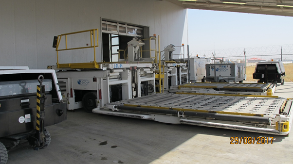
GAAC operations cover the handling in Kabul as below.
|
|
Ground Handling Company |
Contact Ph |
High Loaders Y/N and capacity in Kg |
Belt Loaders (can handle Euro Pallet) |
Availability of Stairs |
|---|---|---|---|---|---|
|
Kabul |
GAAC |
+93700029225 |
Yes – MDL 30 tons |
Yes |
Air Bridge & Stairs |
Ariana/NAS are certified by ISAGO, and technically equipped with
standard loading equipment.
http://www.nas.aero/Network.aspx
Ariana/NAS can load any type of aircraft - no limitation.
Cargo handling facilities HKIA Civilian side:
- 1 x 5 T Forklift
- 3 x Tractor
- 25 x 5T Container Car
- 5 x 5T Pile Car
- 1 x “K” loader
The cost of cargo shipment depends on type of aircraft and the details can be obtained from Ariana/ NAS main office the following address: Kabul, Shirpoor.
Storage
Ariana/NAS do not have any cargo store in Hamid Karzai International Airport. Storage space managed by Customs Authority is available
Storage Facilities
Commercial Storage facilities are not available inside the airport. However, some storage space that belong to the Customs Authority is used to facilitate clearing of cargo arriving by air. All air cargo is offloaded directly to this facility for further processing.
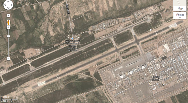
Afghanistan - 2.2.2 Afghanistan Mazar-i-Sharif (Mawlānā Jalāl ad-DīnMuhammad Balkhī ) International Airport
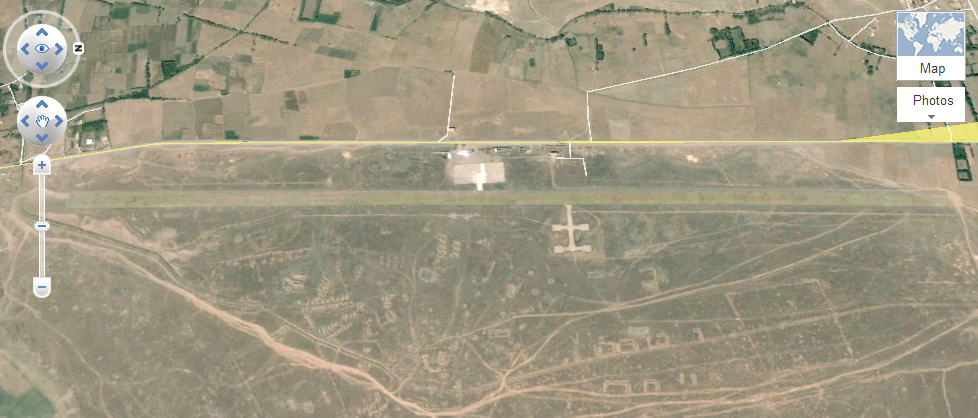
Mazar-i-Sharif International Airport, locally known as Mawlānā Jalāl ad-Dīn Muhammad Balkhī International Airport, is located 9 km east of Mazar-i-Sharif, 15 minutes from the center of the city. The airport is one of the largest airports in Afghanistan. It can handle large aircraft such as Boeing 747, Boeing C-17 Globemaster III and Antonov An-225. Originally built by engineers from the Soviet Union in the 1950s, it has been renovated and a new terminal was added to the airport in recent years while the older terminal is now used for domestic flights.
|
Airport Location and Contact |
|
|---|---|
|
Country |
Afghanistan |
|
Province or District |
Balkh |
|
Nearest Town or City with Distance from Airport |
Mazar-i-Sharif (9 Km) |
|
Airport’s Complete Name |
Mazar-i-Sharif International Airport |
|
Latitude |
36.706914 |
|
Longitude |
67.209678 |
|
Elevation |
392 m / 1,287 ft |
|
IATA Code |
MZR |
|
ICAO Code |
OAMS |
|
Managing Company or Airport Authority |
Ministry of Transport and Civil Aviation |
|
Management Contact Person |
Civil Aerodrome Administration: Afghanistan Airport President: Mawlawi Hafez Hafiz +93744 700 582 +93792214562 OPS Manager:ops@balkhairservices.com |
|
Open From (hours) |
Sunrise |
|
Open To (hours) |
Sunset |
Description and Key Contacts
|
Kabul |
|
|
Tehran-Imam Khomeini, Mashhad |
Runways
|
Runway |
|
|---|---|
|
Runway Dimensions |
2,998 m x 45 m 9,836 ft x 148 ft |
|
Orientation |
66° T / 246° T |
|
Surface |
Asphalt |
Helicopter Pad
|
Helipad #1 |
|
|---|---|
|
Present |
Yes |
|
Largest Helicopter that can Land |
MI-28 Helicopter |
|
Width and Length (m) |
3158 m x 46 m 10,361 ft x 150 ft |
|
Surface |
Asphalt |
Airport Infrastructure Details
|
Customs |
Yes |
JET A-1 fuel |
Yes |
|---|---|---|---|
|
Immigration |
Yes |
AVGAS 100 |
- |
|
Terminal Building |
Yes |
Single Point Refueling |
- |
|
Passenger Terminal |
Yes |
Air Starter Units |
- |
|
Cargo terminal |
Yes |
Ground Power (mobile) |
Yes |
|
Pax Transport to Airfield |
Yes |
Ground Handling Services |
Yes |
|
Control Tower |
Yes |
Latrine Servicing |
Yes |
|
Weather Facilities |
Yes |
Fire Fighting Category (ICAO) |
ICAO Cat 9 |
|
Catering Services |
No info |
De-icing Equipment |
Yes |
|
Base Operating Room |
Yes |
Parking Ramp Lighting |
No |
|
Airport Radar |
Yes |
VOR |
- |
Airport Operating Details
Cargo handling company: Balkh Air Service
Cargo Handling Facilities
|
For Civil Only |
|||
|
Qty |
Equipment |
Aircraft Type |
Brand |
|
1 |
Self-propelled stairs |
All Wide Body |
AMSS |
|
1 |
Towable stairs |
MD83,87; B737 Airbus 319,320 |
TLE |
|
1 |
Self-propelled stairs |
MD83,87; B737 Airbus 319,320 |
AMSS |
|
3 |
Belt loader |
All aircraft |
TLD |
|
4 |
Tractor, diesel |
|
MULAG |
|
14 |
Pallet dolly |
|
LOMMA |
|
6 |
Dolly/Container Dolly turntable LD4 |
|
TCR |
|
10 |
Baggage Cart left side open |
|
TCR |
|
1 |
7T FMC loader (15000 lbs.) 125 inches |
|
Commander 15W |
|
1 |
7T loader (15000 lbs.) 96 inches |
|
Commander 15W |
|
1 |
High loader 40K |
|
|
|
1 |
Loader/40,000lbs |
|
|
|
2 |
Tow bar/Lock pin type |
Airbus 310, 130 |
CLYDE |
|
1 |
Tow bar |
A318, 319, 320, 321 |
CLYDE |
|
1 |
Tow bar |
B737 |
CLYDE |
|
1 |
Tow bar |
B747 |
CLYDE |
|
1 |
Tow bar |
B767-777 |
CLYDE |
|
1 |
Pushback |
|
|
|
1 |
Ramp Ops truck |
|
Suzuki |
|
2 |
Follow-me |
|
Hilux |
|
1 |
Specialized Water truck |
|
Vestergaard |
|
1 |
Specialized Toilet truck |
|
Vestergaard |
|
2 |
ACU |
All aircraft |
Pecoraro |
|
For RS Only: 1 x 2.0 T Hydraulically Lift Truck 2 x 1.6 T Forklift 2 x 3.0 T Forklift 3 x 8.0 T Forklift 1 x 16.0 T Forklift 1 x 10.0 T LTC loader 2 x 16.0 T Atlas “K” loader |
|||
Storage Facilities
Storage is available at the airport
Fuel Service Charges
H24 Civil: Request fuel service on PPR. Kamgar Fuel company is providing the aviation fuel.
2.2.3 Afghanistan Kandahar International Airport
Airport Overview
Kandahar International Airport is located 16 kilometers
southeast of Kandahar City in Afghanistan. Kandahar is a civilian
airfield under the control of Afghanistan Civil Aviation. It serves
as one of main international airports and as one of the largest
military bases, capable of housing up to 250 aircraft of all
type.
Since 2007, the airport has been repaired and expanded. It is used
for both military and civilian flights.

|
Airport Location and Contact |
|
|---|---|
|
Country |
Afghanistan |
|
Province or District |
South Region |
|
Nearest Town Distance from Airport |
Kandahar, 16 kilometers |
|
Airport’s Complete Name |
Kandahar International Airport |
|
Latitude |
31.505756 |
|
Longitude |
65.847822 |
|
Elevation (ft and m) |
1,017 m / 3,337 ft |
|
IATA Code |
KDH |
|
ICAO Code |
OAKN |
|
Managing Company or Airport Authority |
Military - civil Joint use airport |
|
Management Contact Person |
Naqeeb Wafa +93700 312 222 / +93703 098 530 |
|
Open From (hours) |
Sunrise |
|
Open To (hours) |
Sunset |


Description and Contacts of Key Companies
PPR: OAKN is a PPR only airfield. All MIL and civilian ACFT must submit a PPR form no later than 24 hours prior to their ETA and not earlier than 5 days prior. All PPRs must be submitted no later than 2100 Z for the next day. All slot times have a window of ±30 minutes. ACFT not meeting their slot time may be subject to lengthy airborne delay or turned away.
PPR Changes less than 24 hours prior to arrival must be coordinated with KAF Airfield Management.
Commercial Airlines
|
Airlines |
Destinations |
|
Delhi, Dubai-International |
|
|
Dubai-International, Kabul, Mashhad |
Runways
|
Runway |
|
|---|---|
|
Runway Dimensions |
3200m x 55m (10 497ft x 180ft) |
|
Orientation |
050º T / 230 º T |
|
Surface |
Asphalt |
|
Helipad |
|
|---|---|
|
Present |
Yes |
Airport Infrastructure Details
|
Customs |
MIL customs H24 |
JET A-1 fuel |
Fueling by prior approval only |
|---|---|---|---|
|
Immigration |
No |
Fire Fighting Category (ICAO) |
RFF ICAO Cat 9/ ICAO Cat 10 on request |
|
De-icing Equipment |
No |
Ground Handling Services |
Yes* |
* Cargo handling is provided by NAS (National Aviation Service).
For time being this company only provides handling support to
Ariana Airlines. According to NAS representative, they have all
needed equipment for ground handling and they are able to load
/offload any type of aircraft.
Handling costs differ and it depends on types of aircraft and
cargo.
* Cargo handling is provided by GAAC (General Aviation Airport Coalition). For time being GAAC provides handling support in Kabul, Herat and Kandahar airports.
|
|
Ground Handling Comp |
Contact Number |
High Loaders Y/N and capacity in Kg |
Belt Loaders (can handle Euro Pallet |
Availability of Stairs |
|---|---|---|---|---|---|
|
Kandahar |
GAAC |
+93700029232 |
Yes – MDL 14 tons |
Yes |
Stairs |
Handling costs differ and it depends on types of aircraft and
cargo.
2.2.4 Afghanistan Herat International Airport
Airport Overview
|
Location Details |
|||
|---|---|---|---|
|
Country |
Afghanistan |
Latitude |
34.210017 |
|
Province / District |
Herat |
Longitude |
62.228300 |
|
Town or City (Closest) |
Herat |
Elevation |
977 m / 3206 ft |
|
Airfield Name |
Khwaja Abdullah Ansari International Airport |
IATA and ICAO Codes |
HEA/OAHR |
|
Open From (hours) |
Sunrise |
Open To (hours) |
Sunset |
|
RWY Dimensions |
3 014 m x 45 m (9 888 ft x 148 ft) |
RWY details |
Asphalt |
|
RWY Orientation |
187 ° T / 007 ° T |
|
|
Customs and Immigration
Available in civilian terminal for domestic and international passengers.
Airport Services
De-icing currently unavailable.
Before any flight is Operated to Herat, clearance from the Civil Aviation Authorities must be received.
Cargo handling facilities / Civilian Terminal
GAAC provides Cargo handling support in Herat.
|
|
Ground Handling Comp |
Contact Ph |
High Loaders Y/N and capacity in Kg |
Belt Loaders (can handle Euro Pallet |
Availability of Stairs |
|---|---|---|---|---|---|
|
HERAT |
GAAC |
+93700029231 |
Yes – MDL 14 tons |
Yes |
Stairs |
Fuel
Fuel for Civilian ACFT provided by Kamgar petroleum.
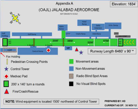
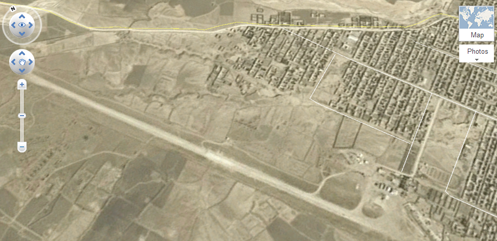
2.2.5 Afghanistan Jalalabad National Airport
Overview
No runway lights, operations must take place only during daylight.
| Airport Location and Contacts | |
|---|---|
| Country | Afghanistan |
|
Province or District |
Jalalabad |
| Nearest Town or City with Distance from Airport | Jalalabad (5 km) |
| Airport's Complete Name | Jalalabad Airport |
| Latitude | 34.2401 |
| Longitude |
70.49833 |
| Elevation | 1,840 ft / 560 m |
| IATA Code | JAA |
| ICAO Code | OAJL |
| Managing Company or Airport Authority | |
| Management Contact Person |
|
| NGO and/or UN Presence at Airport? | Yes |
Information on some aviation service providers can be found at: AZ Freight Website
Runways
| Runway # 1 | |
|---|---|
| Runway Dimensions | 1,970 m x 30 m |
| Runway Orientation | 13/31 |
| Runway Surface | Asphalt |
| Runway Condition | Good |
Airport Infrastructure Details
| Infrastructure | |||
|---|---|---|---|
| Passenger / Cargo Security Screening |
Yes, physical screening only |
Runway Lighting | No |
| Refueling Capacity | No | Ground Handling Services | No |
| Air Traffic Control | No | Fire Fighting Equipment | Yes, fire extinguishers and a fire truck |
| Weather Information | No | Aircraft Parking Space | Yes |
| Navigation Aids | No | Perimeter Fencing | Yes |
| Windsock | Yes | ||
Fuel Service Charges
There are no refueling facilities at Jalalabad Airport.
Royalties / Non-Objection Fees
N/A
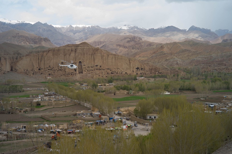
2.2.6 Afghanistan Bamyan National Airport
Overview
Bamyan Aerodrome is 1.4 km northeast from the Bamian town center. It is positioned within the Bamian town limits.
| Airport Location and Contacts | |
|---|---|
| Country | Afghanistan |
| Province or District | Bamyan |
| Nearest Town or City with Distance from Airport | Bamyan (1.4 km) |
| Airport's Complete Name | Shahid Mazari Airport |
| Latitude |
34.812548 |
| Longitude |
67.827355 |
| Elevation | 8415 ft / 2,565 m |
| IATA Code | BIN |
| ICAO Code | OABN |
| Managing Company or Airport Authority | Bamyan Airport Administration |
| Management Contact Person | Mr. Karimi 0093 (0) 790241055 karimi.acaa@gmail.com |
| NGO and/or UN presence at Airport? | Yes |
Runways
| Runway # 1 | |
|---|---|
| Runway Dimensions | 2200 m x 30 m |
| Runway Orientation | 07/25 |
| Runway Surface | Asphalt |
| Runway Condition | Good |
Airport Infrastructure Details
| Infrastructure | |||
|---|---|---|---|
| Passenger / Cargo Security Screening | Yes, physical screening only | Runway Lighting | No |
| Refueling Capacity | Yes | Ground Handling Services | Yes, UNHAS |
| Air Traffic Control | Yes | Fire Fighting Equipment | Yes, fire extinguishers and a fire truck |
| Weather Information | Yes | Aircraft Parking Space | Yes |
| Navigation Aids | No | Perimeter Fencing | Yes, partial |
| Windsock | Yes | ||
Fuel Service Charges
N/A
Royalties / Non-Objection Fees
N/A
2.2.7 Afghanistan Kunduz National Airport
Airport Overview


| Airport Location and Contacts | |
|---|---|
| Country | Afghanistan |
| Province or District | Kunduz |
| Nearest Town or City with Distance to Airport | Kunduz (10 km) |
| Airport's Complete Name | Kunduz Airport |
| Latitude |
36.667044 |
| Longitude |
68.911571 |
| Elevation | 1457 ft / 444 m |
| IATA Code | UND |
| ICAO Code | OAUZ |
| Managing Company or Airport Authority |
|
| Management Contact Information |
Aerodrome Administration Yasin Ayobe (+93786 022 900) |
| NGO and/or UN Presence at Airport | Yes, UNHAS |
Runways
| Runway # 1 | |
|---|---|
| Runway Dimensions | 2469 m x 45 m (8100 ft x 148 ft) |
| Runway Orientation | 11/29 |
| Runway Surface | Asphalt |
| Runway Condition | Good |
Airport Infrastructure
| Infrastructure | |||
|---|---|---|---|
| Passenger / Cargo Security Screening | Yes | Runway Lighting | No |
| Refueling Capacity | No | Ground Handling Services | No |
| Air Traffic Control | Yes | Fire Fighting Equipment | Yes, fire extinguishers and a fire truck |
| Weather Information | Yes | Aircraft Parking Space | Yes |
| Navigation Aids | No | Perimeter Fencing | Yes |
| Windsock | Yes | ||
Fuel Service Charges
N/A
Royalties / Non-Objection Fees
N/A
2.2.8 Afghanistan Maimana National Airport
Airport Overview
| Airport Location and Contact | |
|---|---|
| Country | Afghanistan |
| Province or District | Maimana |
| Nearest Town or Country with Distance to Airport | Maimana (1.6 km) |
| Airport's Complete Name | Maimana Airport |
| Latitude |
35.926189 |
| Longitude |
64.765276 |
| Elevation | 838.81 m / 2,752 ft |
| IATA Code | MMZ |
| ICAO Code | OAMN |
| Managing Company or Airport Authority | |
| Management Contact Person |
Nasrullah Osmani, Airport Manager +93799 778 277 |
| NGO and/or UN Presence at Airport | Yes |
Runways
| Runway #1 | |
|---|---|
| Runway Dimensions | 2000 m x 30 m |
| Runway Orientation | 14/32 |
| Runway Surface | Asphalt |
| Runway Condition | Good |
Airport Infrastructure Details
| Airport Infrastructure Details | |||
|---|---|---|---|
| Passenger / Cargo Security Screening | Yes, UNHAS | Runway Lighting | No |
| Refueling Capacity | No | Ground Handling Services | No |
| Air Traffic Control | No | Fire Fighting Equipment | Fire extinguishers only |
| Weather Information | Yes | Aircraft Parking Space | Yes |
| Navigation Aids | Yes | Perimeter Fencing | Yes, partial |
| Windsock | No | ||
Fuel Service Charges
N/A
Royalties / Non-Objection Fees
N/A
2.2.9 Afghanistan Fayzabad National Airport
Airport Overview
Feyzabad Aerodrome is located 12km west of the city of
Feyzabad.
| Airport Location and Contact | |
|---|---|
| Country | Afghanistan |
| Province or District | Badakhshan |
| Nearest Town or City with Distance to Airport | Fayzabad (7 km) |
| Airport's Complete Name | Fayzabad Airport |
| Latitude |
37.121238 |
| Longitude |
70.517471 |
| Elevation | 3842 ft / 1171 m |
| IATA Code | FBD |
| ICAO Code | OAFZ |
| Managing Company or Airport Authority | |
| Management Contact Person |
Mr. Jawad, +93790 090 031 |
| NGO and / or UN Presence at Airport | Yes, UNHAS |
Runway
| Runway # 1 | |
|---|---|
| Runway Dimensions | 2000 m x 30 m |
| Runway Orientation | 18/36 |
| Runway Surface | Asphalt |
| Runway Condition | Good |
Airport Infrastructure Details
| Infrastructure | |||
|---|---|---|---|
| Passenger / Cargo Screening | Yes, UNHAS | Runway Lighting | No |
| Refueling Capacity | Yes, Jet A1/TC1 | Ground Handling Services | No |
| Air Traffic Control | Yes | Fire Fighting Equipment | Yes, fire extinguishers only |
| Weather Information | Yes | Aircraft Parking Space | Yes |
| Navigation Aids | No | Perimeter Fencing | No |
| Windsock | Yes | ||
Fuel Service Charges
Arrow Petroleum
Johnson Kumar, Operation Department
Cell #: +93 (0) 744522286 – 797745549
ops@arrowpetroleum.com, www.arrowpetroleum.com
Royalties / Non-Objection Fees
N/A
2.2.10 Afghanistan Chakcharan National Airport
Airport Overview


No PPR required. Fuel is not available. Operations must take place only during daylight. There are non-standard white markings along the runway, similar to touchdown marks. All markings are non-reflective and with no lighting.
| Airport Location and Contact | |
|---|---|
| Country | Afghanistan |
| Province or District | Chakcharan |
| Nearest Town or City with Distance from Airport | Chakcharan (1.5 km) |
| Airport's Complete Name | Chakcharan Airport |
| Latitude |
34.525489 |
| Longitude |
65.265140 |
| Elevation | 7,475 ft / 2,278 m |
| IATA Code | CCN |
| ICAO Code | OACC |
| Managing Company or Airport Authority | |
| Management Contact Person | |
| NGO and/or UN Presence at Airport? | |
Runways
| Runway # 1 | |
|---|---|
| Runway Dimensions | 2,000 m x 30 m |
| Runway Orientation | 06/24 |
| Runway Surface | Asphalt |
| Runway Condition | Good |
Airport Infrastructure Details
| Infrastructure | |||
|---|---|---|---|
| Passenger / Cargo Screening | Yes, physical screening | Runway Lighting | No |
| Refueling Capacity | No | Ground Handling Services | No |
| Air Traffic Control | Yes | Fire Fighting Equipment | Yes, fire extinguishers only |
| Weather Information | Yes | Aircraft Parking Space | Yes |
| Navigation Aids | No | Perimeter Fencing | Yes, but damaged in some places |
| Windsock | Yes | ||
Fuel Service Charges
N/A
Royalties / Non-Objection Fees
N/A
For information on Afghanistan Aviation contact details, please see the following links:
4.2.1 Afghanistan Government Contact List and 4.2.5 Afghanistan Airport Company Contact List
Information on some aviation service providers can be found at: AZ Freight Website
2.2.11 Afghanistan Qala l Naw National Airport
Airport Overview
|
Airport Location and Contact |
|
|---|---|
|
Country |
Afghanistan |
|
Province or District |
Badghis Province |
|
Nearest Town or City |
Qala-i-Naw (1.6 km) |
|
Airport’s Complete Name |
Qala-i-Naw Airport |
|
Latitude |
34.5909 |
|
Longitude |
63.0704 |
|
Elevation (ft and m) |
2,968 ft / 905 m |
|
IATA Code |
LQN |
|
ICAO Code |
OAQN |
|
Managing Company or Airport Authority |
Afghanistan Civil Aviation Authority |
|
Management Contact Person |
Aerodrome
Administration: |
|
NGO and/or UN Presence at Airport? |
|
Runway(s)
|
Runway #1 |
|
|---|---|
|
Runway Dimensions |
2000 m x 25 m |
|
Runway Orientation |
04/22 |
|
Runway Surface |
Concrete |
|
Runway Condition |
Concrete surface has deteriorated. |
Airport Infrastructure Details
|
Infrastructure |
|||
|---|---|---|---|
|
Passenger / Cargo Security Screening |
Physical screening only |
Runway Lighting |
No |
|
Refueling Capacity |
No |
Ground Handling Services |
No |
|
Air Traffic Control |
Yes, advisory only. |
Fire Fighting Equipment |
Yes, fire extinguishers only |
|
Weather Information |
Yes |
Aircraft Parking Space |
Yes |
|
Navigation Aids |
No |
Perimeter Fencing |
Yes, partial |
|
Windsock |
No |
|
|
Due to reduced ramp availability, overnight parking can only be approved as an exception and it has to be requested by PPR or due to emergency or ACFT malfunction.
2.2.12 Afghanistan Farah National Airport
Airport Overview
|
Airport Location and Contact |
|
|---|---|
|
Country |
Afghanistan |
|
Province or District |
Farah Province |
|
Nearest Town or City with Distance from Airport |
Farah City (4 km) |
|
Airport’s Complete Name |
Farah Airport |
|
Latitude |
32.366560 |
|
Longitude |
62.160957 |
|
Elevation (ft and m) |
2212 ft / 674 m |
|
IATA Code |
FAH |
|
ICAO Code |
OAFR |
|
Managing Company or Airport Authority |
Afghanistan Civil Aviation Authority |
|
Management Contact Person |
Farah Aerodrome Administration: Mr. Jamshid Raji |
|
NGO and/or UN Presence at Airport? |
No |
Aerodrome reference point 322149N 0621003E.
Runway(s)
|
Runway #1 |
|
|---|---|
|
Runway Dimensions |
2500 m X 35 m |
|
Runway Orientation |
15/33 |
|
Runway Surface |
Asphalt |
|
Runway Condition |
Good |
For
information on Afghanistan Aviation contact details, please see the
following link:
http://acaa.gov.af/Content/files/AERODROME%20EDITION%2082-22%20JUN%20%202017.pdf
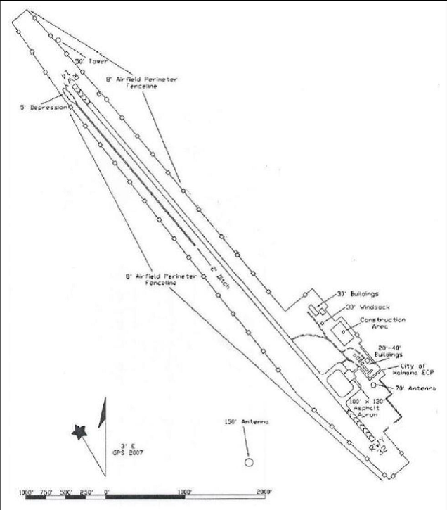
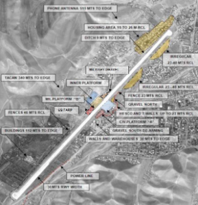
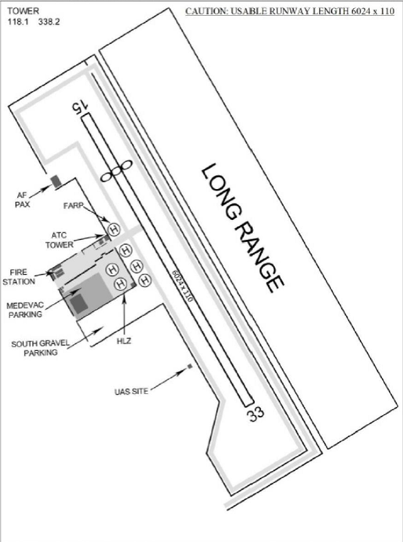
2.2.13 Afghanistan Shindand National Airport
Airport Overview
This aerdrome operates from : 01:30Z–15:30Z
|
Airport Location and Contact |
|
|---|---|
|
Country |
Afghanistan |
|
Province or District |
Herat Province |
|
Nearest Town or City with Distance from Airport |
Shindand (11 km northeast) |
|
Airport’s Complete Name |
Shindand Airport |
|
Latitude |
33.385899 |
|
Longitude |
62.254715 |
|
Elevation (ft and m) |
3,780 ft / 1,152 km |
|
IATA Code |
OAH |
|
ICAO Code |
OASD |
|
Managing Company or Airport Authority |
|
|
Management Contact Person |
|
|
NGO and/or UN Presence at Airport? |
No |
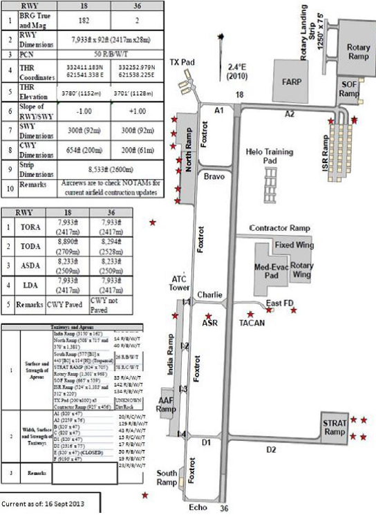
Airport Infrastructure Details
|
Infrastructure |
|||
|---|---|---|---|
|
Passenger / Cargo Security Screening |
n/a |
Runway Lighting |
n/a |
|
Refueling Capacity |
n/a |
Ground Handling Services |
n/a |
|
Air Traffic Control |
n/a |
Fire Fighting Equipment |
n/a |
|
Weather Information |
n/a |
Aircraft Parking Space |
n/a |
|
Navigation Aids |
n/a |
Perimeter Fencing |
n/a |
|
Windsock |
n/a |
|
|
Cargo
Handling: Limited cargo download capabilities exist for MIL
missions only. Do not send more than one “pallet train” on an
ACFT. No refrigeration
capabilities.
1 10K A/T Forklifts, 2 NGSL
K–loaders and 1–60K Loader for cargo
upload/download.