Jamaica - 2 Logistics Infrastructure
Jamaica sits at the intersection of several maritime and aviation routes to the Americas, Europe and Western Africa. The port industry in Jamaica is developed through public and private partnerships with sector integration. There is also development of national infrastructure assets such as ports, airports, road networks and the creation of special economic zones underway.
An example of road development is the toll road from Kingston to Ocho Rios, which 67 km (41.6 miles) long and goes from the north to south of Jamaica. It’s a brand-new state of the art tolled 4-lane highway and cuts a nearly two-hour drive down to 50 minutes. There are also alternate routes without tolls and other road networks across the island’s highlands. These available structures could be used as an alternate solution during a major disaster, with a major transit time between cities. There are some structural issues and minor road degradation to be found, such as mountainous terrains with unpaved and paved roads.
The road network between the major cities on the northern island are in good condition, specifically between Ocho Rios – Montego Bay.
The Ministry of Industry, Investment and Commerce (MIIC) has an initiative program for a Jamaica Global Hub. It involves the creation and expansion of special economic zones across the island, aviation repair and maintenance, ship repair, dry docking zones and the establishment of effective investor programs.
Jamaica - 2.1 Port Assessment
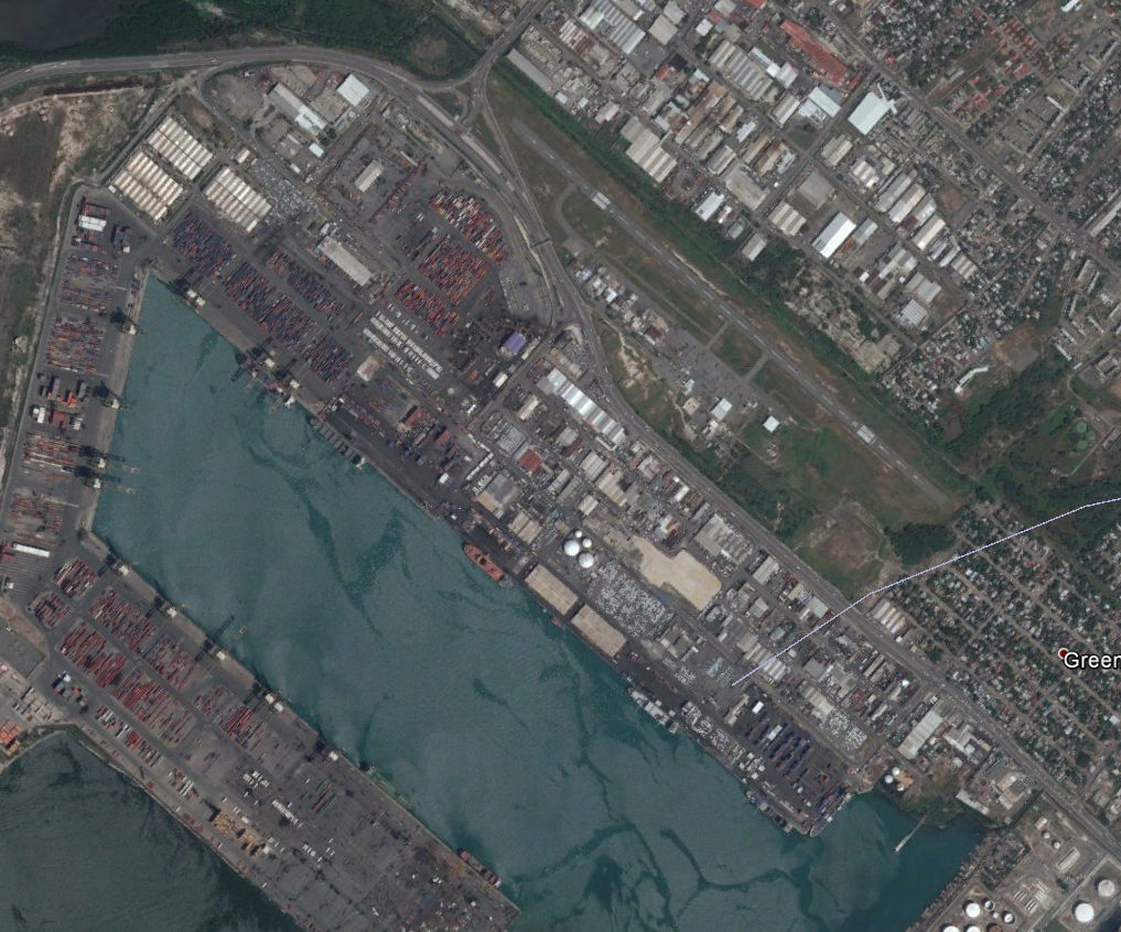
The Kingston Container Terminal (KCT), owned by the Port Authority of Jamaica (PAJ), has been operated by Kingston Freeport Terminal Limited (KFTL), a subsidiary of the CMA CGM Group, since July 1, 2016, under a Build Operate Transfer (BOT) Concession Agreement (CA). According to this agreement, PAJ earns revenue from annual concession fees, consisting of both fixed and variable portions based on the gross revenues generated by KFTL.
The Port of Montego Bay, also owned by the Port Authority, is a versatile port handling both cargo and cruise activities. Cargo operations are managed by Port Handlers Limited (PHL) through a management agreement. While PAJ retains responsibility for development and equipment investments, PHL oversees daily operations and is compensated with a management fee.
Cruise port development and maintenance across Jamaica fall under the purview of the PAJ. The country's cruise port facilities include the Port of Montego Bay, Historic Port of Falmouth, Port of Ocho Rios, Ken Wright Pier with the adjoining Errol Flynn Marina, and the newly constructed Historic Naval Dockyard in Port Royal. PAJ manages the Historic Port of Falmouth, Errol Flynn Marina, and the Historic Naval Dockyard. Additionally, the Port of Montego Bay and Port of Ocho Rios are operated by PHL and Lannaman and Morris, respectively, through management agreements. Marketing efforts for cruise shipping are coordinated by the Port Authority of Jamaica under its "Cruise Jamaica" brand.
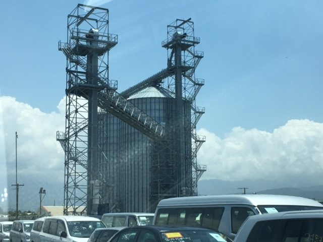
Kingston Wharves Limited Terminal is the leading multipurpose terminal in Kingston. It provides customized services, cargo handling, warehousing, bulk cargo (maize), a conveyor belt accessible terminal, silos, containers and reefer plugs.
Jamaica - 2.1.1 Port of Kingston Freeport Terminal LTD
Port Overview
Jamaica’s strategic location and the fact that it is situated on a natural harbour makes the terminal’s core business container transshipment. It is considered the main gateway for containerized cargo.
Kingston Freeport Terminal Limited (KFTL), a subsidiary of CMA CGM, is responsible for the development, maintenance and operation of the Kingston Container Terminal, through a 30- year concession arrangement between the Government of Jamaica and CMA CGM which commenced on 1st July 2016.
The terminal seeks to capitalize on the many opportunities available, particularly those afforded by its ideal location, 32 nautical miles off the main trade route coming out of the Panama Canal. With the growing demand for a transshipment hub capable of servicing the larger vessels to be accommodated by the newly expanded canal, KFTL’s place in the market will be solidified with the current improvements to its infrastructure. These improvements include the widening and deepening of the Kingston Harbour access channel, the turning circle and the terminal basin, to accommodate vessels with a draft of up to 15.5 meters.
Additionally, the improvements will facilitate the strengthening of the quay wall, thereby allowing the quay to accommodate the larger and heavier ship-to-shore cranes to serve these larger mother vessels.
Shipping lines connecting at KFTL will benefit from increased capability to take advantage of easy and convenient access to markets in Europe, Asia and America, thus providing a more diverse product to their customers.
90% of the cargo that arrives through this terminal is considered for transshipment and 10% considered as domestic.
es through this terminal is considered for transhipment and 10% considered as domestic.
Port website: http://www.kftl-jm.com/
Key port information may also be found at: http://www.maritime-database.com
|
Port Location and Contact |
|
|---|---|
|
Country |
JAMAICA |
|
Province or District |
KINGSTON |
|
Nearest Town or City with Distance from Port |
KINGSTON 3.3 km |
|
Port's Complete Name |
KINGSTON FREEPORT TERMINAL LIMITED |
|
Latitude |
1759.0N |
|
Longitude |
7650.0W |
|
Managing Company or Port Authority |
KINGSTON FREEPORT TERMINAL LIMITED |
|
Management Contact Person |
Thomas Vernier (Deputy CEO) |
|
Nearest Airport and Airlines with Frequent International Arrivals/Departures |
NORMAN MANLEY INTERNATIONAL AIRPORT DELTA, JETBLUE, CARRIBEAN AIRLINES, AMERICAN AIRLINES, SPRINT AIRLINES, FLY JAMAICA, AIR CANADA, COPA, UNITED, BRITISH AIRWAYS, CAYMAN AIRWAYS |
Port Picture
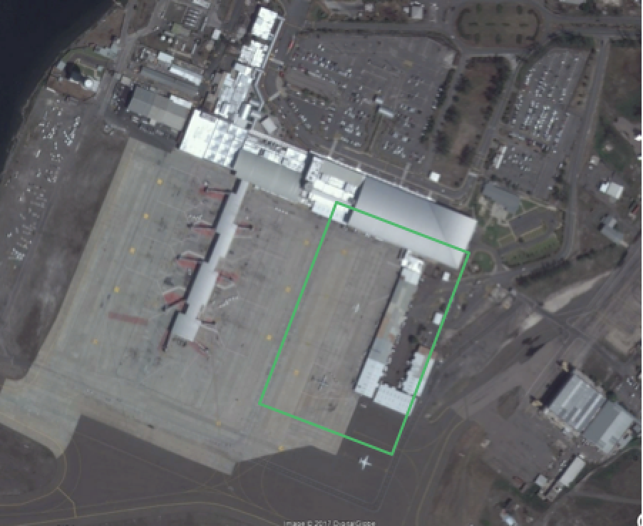
Kingston Freeport Terminal Limited, (the area bordered in yellow), consists of three terminals: the North, South and West Terminals.
Description and Contacts of Key Companies
- Port Authority of Jamaica (PAJ) who are the landlords of the terminal. Tel: 922-0290.
- Jamaica Customs Agency which conducts the processing of all import/export/transshipment cargo and the examination and release of domestic cargo. Tel: 922-5140.
- Immigration Department which verifies the status of crew and grants access to the island Tel: 469-1605.
For more information on port contacts, please see the following link: 4.4 Jamaica Port and Waterways Companies Contact Lists
Port Performance
Since July 2016, KFTL has taken many significant steps to increase the availability of equipment and improve the efficiency of its internal operations. This has contributed to a significant increase in berth productivity and a decrease in the average truck turn-around time to below 30 minutes.
Efficiency is expected to further increase with the deepening of the channel and turning basin. The current draft of 13.5m is expected within the first phase of upgrades to increase to 14.7m to accommodate 14,000 TEU vessels. This will enable the port to accommodate vessels of up 14,000 TEUs. The second phase involves dredging to a depth that will accommodate vessels of 15.5m draft which will enable the port to accommodate fully laden 14,000 TEU vessels.
|
Seasonal Constraints |
||
|---|---|---|
|
Occurs |
Time Frame |
|
|
Rainy Season |
N/A |
N/A |
|
Major Import Campaigns |
N/A |
N/A |
|
Handling Figures for 2016 |
|
|---|---|
|
Vessel Calls |
1,514 |
|
Container Traffic (TEUs) |
1,343,291 |
|
Handling Figures Bulk and Break Bulk for 2016 |
|
|---|---|
|
Bulk (mt) |
|
|
Break bulk (mt) |
50 units |
Discharge Rates and Terminal Handling Charges (Public Tariffs)
|
Stevedoring Charges |
20ft |
40ft |
|---|---|---|
|
DOMESTIC HANDLING |
US$ |
US$ |
|
Discharge or loading of domestic full containers |
240.00 |
240.00 |
|
Discharge or loading of domestic empty containers |
240.00 |
240.00 |
|
Discharge or loading of domestic OOG containers - A |
360.00 |
360.00 |
|
Discharge or loading of domestic OOG containers - B |
455.00 |
455.00 |
|
TRANSSHIPMENT HANDLING |
US$ |
US$ |
|
Discharge or loading of transshipment full containers |
s90.00 |
90.00 |
|
Discharge or loading of transshipment empty containers |
90.00 |
90.00 |
|
Discharge or loading of transshipment OOG containers - A |
135.00 |
135.00 |
|
Discharge or loading of transshipment OOG containers - B |
300.00 |
300.00 |
|
Discharge or loading of hatch covers |
270.00 |
270.00 |
|
RESTOW HANDLING |
90.00 |
90.00 |
|
Note: The discharge/load charges include a single cycle movement from ship to stack for the discharge cycle and from stack to ship on the load cycle. Any additional crane lift required by the line must be made formally in writing and such movements are chargeable as per above rates. |
||
|
SHIFTING CONTAINERS |
US$ |
US$ |
|
At Line/Agent request on terminal – full or empty |
45.00 |
45.00 |
|
At Line/Agent request off terminal – full or empty |
45.00 |
45.00 |
|
Handling of empty containers for export collections |
45.00 |
45.00 |
REEFER CHARGES – ELECTRICITY PLUG & USAGE
The use of the terminal’s reefer plugs/electrical outlets will attract a charge for electricity usage.
The charge is applied per day or parts thereof, per unit, commencing on the day of discharge (all days of the week included), and the day commences at 07:00 hours.
|
|
PER CONTAINER US$ |
|---|---|
|
Local cargo (Consignee account) per day |
60.00 |
|
Transshipment cargo (Line account) per day |
50.00 |
|
Pre-Trip inspection (PTI) |
50.00 |
|
Fuel/Electricity Surcharge per day per unit |
*** |
Note: These charges are in addition to the appropriate container handling charge and storage. Work orders must be completed for any request for movement of reefer cargo, and will be carried out as per such request at additional costs (see rate for shifting).
STRIPPING/STUFFING
a. Stripping means unloading cargo from a container
b. Stuffing means loading cargo into a container
c. The act of stripping or stuffing includes checking, removing/attaching relevant seals and labels and the usage of specified labour and equipment (securing material to be supplied by the shipping company).
|
|
PER TEU/FEU/HC (US$) |
|
|---|---|---|
|
Stripping / Stuffing (TEU) |
385.00 |
620.00 (HC) |
|
Stripping / Stuffing (FEU) |
650.00 |
750.00 (HC) |
|
Stripping / Stuffing > FEU |
720.00 |
850.00 (HC) |
|
Reconsolidation of cargo (TEU) |
630.00 |
1000.00 (HC) |
|
Reconsolidation of cargo (FEU) |
1075.00 |
1250.00 (HC) |
|
Reconsolidation of cargo > FEU |
1150.00 |
1285.00 (HC) |
Berthing Specifications
|
Type of Berth |
Quantity |
Length (m) |
Maximum Draft (m) |
Comments |
|---|---|---|---|---|
|
Conventional Berth |
N/A |
|
||
|
Container Berth |
3 |
2,400m |
13.5m |
|
|
Silo Berth |
N/A |
|
||
|
Berthing Tugs |
N/A |
|
||
|
Water Barges |
N/A |
|
Port Handling Equipment
Port equipment is owned and operated by KFTL.
|
Equipment |
Available |
Total Quantity and Capacity Available |
Comments on Current Condition and Actual Usage |
|---|---|---|---|
|
Dockside Crane |
No |
||
|
Container Gantries |
Yes |
14 |
|
|
Mobile Cranes |
No |
||
|
Reachstacker |
Yes |
2 |
|
|
RoRo Tugmaster (with Trailer) |
No |
||
|
Grain Elevator with Bagging Machines |
No |
||
|
Transtainer |
No |
||
|
Forklifts |
Yes |
9 |
Container Facilities
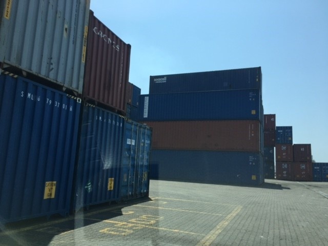
Containers are stored in the container yard which is approximately 100 hectares in size. Refrigerated containers are stored in one of the two reefer areas on the terminal, and non-refrigerated units (dry vans) are stored in areas dependent on whether they are for transhipment or the domestic market.
|
Facilities |
20 ft |
|---|---|
|
Container Facilities Available |
909,397.5 m2 |
|
Container Freight Station (CFS) |
N/A |
|
Refrigerated Container Stations |
26,151 m2 |
|
Other Capacity Details |
N/A |
|
Daily Take Off Capacity |
|
|
Number of Reefer Stations |
744 |
|
Emergency Take-off Capacity |
N/A |
|
Off take Capacity of Gang Shift |
Customs Guidance
Customs officers are stationed at the port and their main function is to protect government revenue and facilitate border control.
Processing of documents is immediate, providing that all required documentation is received. In an effort to achieve optimum efficiency in the clearance process it is recommended that importers provide timely and accurate information relating to the movement of goods.
For more information on customs in Jamaica, please see the following link: 1.3 Jamaica Customs Information
Terminal Information
MAIN STORAGE TERMINAL
|
Storage Type |
Number of Storage Facilities |
Area (m2) |
|---|---|---|
|
Bagged Cargo |
N/A |
|
|
Refrigerated Cargo |
2 |
26,151 |
|
General Cargo |
N/A |
Stevedoring
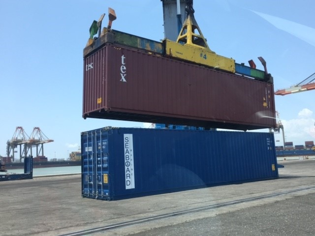
KFTL performs all stevedoring activities which consist of the loading and unloading of ships and the performance of various tasks required when the vessel is in port, including lashing and unlashing of cargo.
Hinterland Information
Goods are transported out of the port by trucks. Most trucking companies are members of the Port Trailer Haulage Association (PTHA) and all trucking companies operating at the port must be registered with the Shipping Association of Jamaica (SAJ). There are also vessels that depart Kingston and travel coastwise to the north (Montego Bay) that transport cargo to that region of the island.
Contact numbers: PTHA (876) 757-8717; SAJ (876) 923-3491.
Port Security
KFTL operates a hybrid security system consisting of a proprietary security team which works with various arms of local and international law enforcement, as well as private contractors.
There is a strong safety culture in which persons working on the facility must always wear personal protective equipment (PPE) (safety vests, gloves, goggles, safety shoes, etc.). There is constant training and a safety induction system for both staff and contractors/visitors to the terminal.
.
|
Security |
|
|---|---|
|
ISPS Compliant |
Yes |
|
Current ISPS Level |
1 |
|
Police Boats |
Yes (Marine Police) |
|
Fire Engines |
Yes (York Park Fire Station) |
Jamaica - 2.1.2 Port of Kingston Wharves Limited
Port Overview
Kingston Wharves Limited is a multipurpose port terminal operator, connecting Jamaican importers and exporters to over 20 international ports in the Caribbean, Latin and North America. Strategically located at the Port of Kingston, the Kingston Wharves Terminal operates 24 hours per day, 365 days per year. The port has existed since 1945, and following the 1995 expansion, Kingston Wharves Terminal now encompasses 1600 m of berthing space and 22 ha of open storage, with 30,000 m2 of covered warehousing and cold storage.
The Port Authority of Jamaica (PAJ), established by the government, manages the port.
Port website: http://kingstonwharves.com.jm/
Key port information may also be found at: http://www.maritime-database.com
|
Port Location and Contact |
|
|---|---|
|
Country |
JAMAICA |
|
Province or District |
KINGSTON |
|
Nearest Town or City with Distance from Port |
KINGSTON DISTANCE 0 (km) |
|
Port's Complete Name |
Kingston Wharves Terminal |
|
Latitude |
17°58’W |
|
Longitude |
76°48’N |
|
Managing Company or Port Authority |
PORT AUTHORITY OF JAMAICA |
|
Management Contact Person |
VALRIE CAMPBELL |
|
Nearest Airport and Airlines with Frequent International Arrivals/Departures |
NORMAN MANLEY INTERNATIONAL AIRPORT (NMIA) |
Port Picture
Description and Contacts of Key Companies
For more information on port company contact details, please see the following link: 4.4 Jamaica Port and Waterways Companies Contact Lists
Port Performance
The side of Kingston Port operated by Kingston Wharves Limited is primarily used and recognized as a multipurpose terminal. It handles containers, RoRo, bulk cargo, general cargo, and additional commodities.
|
Seasonal Constraints |
||
|---|---|---|
|
Occurs |
Time Frame |
|
|
Rainy Season |
N/A |
N/A |
|
Major Import Campaigns |
N/A |
N/A |
|
Other Comments |
Caribbean hurricane season (June - November) |
|
|
Handling Figures for 2016 |
|
|---|---|
|
Vessel Calls |
|
|
Container Traffic (TEUs) |
230,971 |
Discharge Rates and Terminal Handling Charges
For information on port rates and charges, please see the following link: http://kingstonwharves.com.jm/charges/
Berthing Specifications
|
Type of Berth |
Quantity |
Length (m) |
Maximum Draft (m) |
Comments |
|---|---|---|---|---|
|
Conventional Berth |
9 |
1,655 |
12.7 |
Berths 1 – 7: 23 metres |
|
Container Berth |
|
|||
|
Silo Berth |
|
|||
|
Berthing Tugs |
|
|||
|
Water Barges |
|
The total length of continuous quay measures 1,655m (5,430 ft). Vessel Draft: 9m (29 ft) to 13m (42 ft).
On-Dock Open Storage: Approximately 250,000 square meters or 2,694,000 square ft ft. On-Dock Transhipment Car Park: 48,562 sqm or 522,720 sq. ft.
On-Dock Warehouse Storage: 16,680 square meters or 180,00 square ft. ft.
Off-Dock Storage: 20,000 sqm or 215,000 sq. ft.
Reefer Plugs: 172 at 440 volts
General Cargo Handling Berths
|
Cargo Type |
Berth Identification |
|---|---|
|
Imports - Bagged Cargo |
N/A |
|
Exports - Bagged Cargo |
N/A |
|
Imports and Exports - RoRo |
59,000 motor moves |
|
Other Imports |
1.7 million mt for domestic tonnage |
Port Handling Equipment
The port equipment is managed by the government.
|
Equipment |
Available |
Total Quantity and Capacity Available |
Comments on Current Condition and Actual Usage |
|---|---|---|---|
|
Dockside Crane |
No |
||
|
Container Gantries |
No |
||
|
Mobile Cranes |
Yes |
6 |
|
|
Reachstacker |
Yes |
18 |
|
|
RoRo Tugmaster (with Trailer) |
Yes |
1 |
|
|
Grain Elevator with Bagging Machines |
Yes |
Elevator and conveyor belt |
|
|
Transtainer |
No |
||
|
Forklifts |
Yes |
Container Facilities
|
Facilities |
20 ft |
40 ft |
|---|---|---|
|
Container Facilities Available |
|
|
|
Container Freight Station (CFS) |
||
|
Refrigerated Container Stations |
176 |
|
|
Other Capacity Details |
1 Empty container handlers 14 Trucks 15 Bomb Carts 6 Mobile Harbour Cranes 1 Toploader 18 Reach stackers 1 Terberg Tug Master |
|
|
Daily Take Off Capacity |
||
|
Number of Reefer Stations |
172 |
At 440 Volts |
|
Emergency Take-off Capacity |
|
|
|
Off take Capacity of Gang Shift |
Customs Guidance
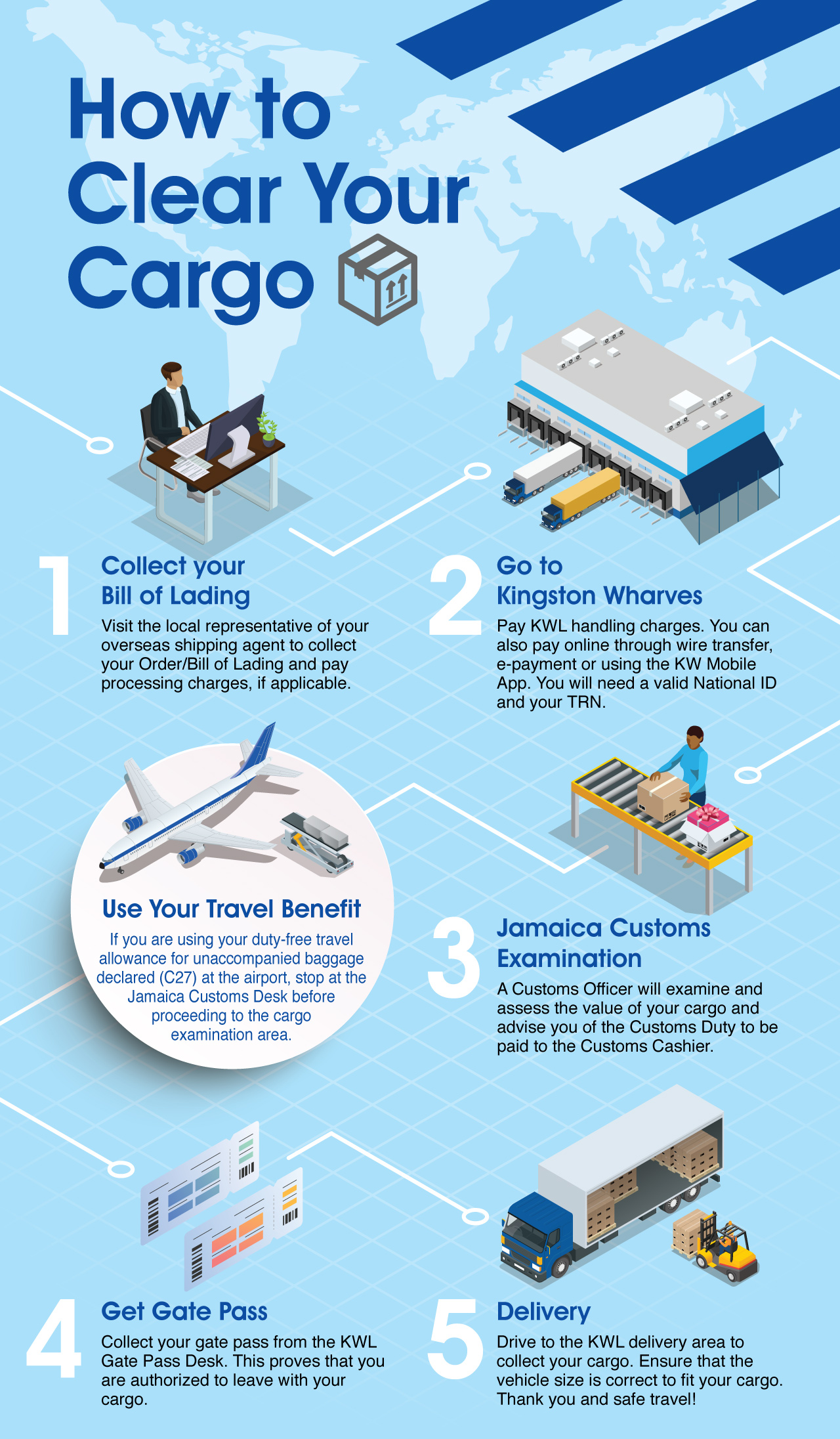
For information and guidance on customs at Kingston Wharves Ltd, please see the following links:
https://kingstonwharves.com/wp-content/uploads/2019/11/Infographic-Carg…
https://kingstonwharves.com/steps-to-clearing-cargo/
For more information on customs in Jamaica, please see the following links: 1.3 Jamaica Customs Information
Terminal Information
MULTIPURPOSE TERMINAL
Kingston Wharves is the leading multipurpose port terminal and logistics provider adjacent to Jamaica’s capital city. It operates 24 hours per day, 365 days per year.
GRAIN AND BULK HANDLING
The terminal has availability for 2 Silos with a capacity of 4,500 mt each. They are connected through a conveyor belt and 2 grain elevators. Dispatch is done manually. There are hoppers and clam shells available at the terminal.
MAIN STORAGE TERMINAL
Currently, Kingston Wharves Limited Terminal operates three multipurpose warehouses with a combined space of 165,000 sq. ft.
Port Security
Since its enactment in July 2004, Kingston Wharves Limited operates an international port facility with certification under the International Ship & Port Facility Security (ISPS) Code.
The terminal incorporates closely monitored electronic access controls, wide ranging closed-circuit video surveillance, modern radiation portal monitors and x-ray examinations through a number of Vehicle and Cargo Inspection Systems (VACIS) deployed at the facilities.
|
Security |
|
|---|---|
|
ISPS Compliant |
YES |
|
Current ISPS Level |
Level 1 |
|
Police Boats |
N/A |
|
Fire Engines |
YES |
Jamaica - 2.1.3 Port of Falmouth
Port Overview
Historically, Falmouth has been a unique cruise destination, located on the north coast of Jamaica, 22 miles east of the world-famous resort city of Montego Bay. The cruise terminal comprises approximately 28 acres of reclaimed lands and previously existing shoreline, and commenced operations in March 2011. Since 2014 the port has averaged over 700,000 annual cruise passenger arrivals from around 179 cruise calls. This facility is solely dedicated to cruise vacationers and facilitates the undertaking of shore-side excursions for cruise guests.
This state-of-the-art cruise terminal is a joint venture development between the Port Authority of Jamaica (PAJ) and Royal Caribbean Cruise Lines. It includes a two-berth pier and can accommodate the largest cruise ships in the world. The terminal was developed as the first thematic cruise terminal in the Caribbean, and consists of wide and varied retail offerings and entertainment. The Port Authority of Jamaica holds management responsibility for port operations, and Royal Caribbean Cruise Lines manages the retail space.
The border control and law enforcement agencies of the Government of Jamaica maintain a presence during cruise operations. They include: (1) The Jamaica Customs Agency JCA, (2) The Passport Immigration and Citizenship Agency (PICA), (3) The Jamaica Constabulary Force (marine police and regular law enforcement), (4) The Department of Health, and (5) Quarantine Unit.
Port website: http://www.cruisejamaica.com
|
Port Location and Contact |
|
|---|---|
|
Country |
JAMAICA |
|
Province or District |
Falmouth, Trelawny |
|
Nearest Town or City with Distance from Port |
Montego Bay 35 km |
|
Port's Complete Name |
Falmouth Cruise Ship Terminal |
|
Latitude |
18° 30N |
|
Longitude |
77° 39W |
|
Managing Company or Port Authority |
The Port Authority of Jamaica (PAJ) manages this facility and has sole responsibility for access control, berthing, vessel scheduling and security arrangements. Royal Caribbean Cruise Lines (RCCL) manages retail operations, through its local subsidiary, Falmouth Jamaica Land Company (FJLCL). |
|
Management Contact Person |
Mark A. Hylton, Port Manager Karla Huie, Assistant Vice President – Business Management & Special Projects |
|
Nearest Airport and Airlines with Frequent International Arrivals/Departures |
Sangster International Airport International carriers: there are several international carriers, including American Airlines, JetBlue, Spirit, Air Canada, British Airways, Virgin Airways, Tui, Delta, South West, and United Airlines. |
Port Picture
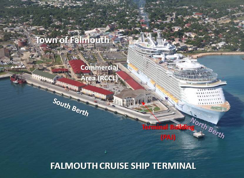
Areas identified in port picture:
- Town of Falmouth
- Terminal Building – managed and occupied by PAJ. It also has offices for Customs, the Ministry of Health, Immigration, and Quarantine.
- North Berth/South Berth at Falmouth Cruise Ship Terminal.
- Commercial area on the port managed by Falmouth Jamaica Land Company Limited (FJLCL), a subsidiary of Royal caribbean Cruise Limited (RCCL).
Contacts of Key Companies
The Port Authority of Jamaica engages the following contractors to provide services for the operations of the cruise terminal, in furtherance of its business;
- The Port Security Corps (PSC): this governmental security organisation offers security services at Free Zone, airports and shipping terminals. The PSC is responsible for access control, CCTV monitoring, berth patrol, X-Ray machine operations and passenger / crew screening at the Falmouth Cruise Ship Terminal.
Tel: (876) 967-5366 – 9 Email: mdpsc@cwjamaica.com - B. International offers fork lifting and linesmen services for the Falmouth Cruise Ship Terminal. Tel: (876) 758-3636 or 7852 Email:Keisha.samuels@bintageltd.com
- Marksman Limited is a registered private security company, a member of the Guardsman Group. Marksman is contracted by the Port Authority of Jamaica to provide dispatching services for cruise guests and vehicles embarking on sightseeing and excursion activities.
Tel: (876) 926-3600 Email: repsteine@guardsmangroup.com
Port Performance
Falmouth is located at 18° 30’N, 77° 38.5’W. The port is situated in a resort and tourist centre, and is the chief town of the parish of Trelawny, County Cornwall.
Limiting Conditions
Controlling depth: The entrance channel was dredged in 2009 to a depth of 12.6 m with a width of 200 m at its narrowest point, which is marked by beacons.
Navigable width: The dredged entrance has a navigable width of 300 m.
Berths: Depth alongside: 11.3 m. Maximum ship’s draught: 10.1 m
Tenders: Tender service is not available.
Maximum size of vessels handled: 360 m in length, with a draft of 10.6 m.
Local weather: NE winds prevail by day, SE by night. NE winds are strongest between May and October.
Arrival Information
Port Radio: Port Radio is connected through the pilots. Pilots communicate on local VHF radio channel 16 and 11.
ETA: Notice of ETA should be sent 96, 48 and 24 hours in advance. Pilot requires 24 hours’ notice.
Pilotage: Pilotage is compulsory and available day and night. Arrangements can be made through the Pilotage Department in Kingston. Pilot boards one mile NE of harbour entrance or Lat. 18° 30.6’N Long. 77° 38’W. Pilotage charges are calculated according to GRT.
Tugs: Tugs may be available from Montego Bay. 10 hours lead time is required and it will take three hours from Montego Bay.
Harbour
Falmouth Harbour is a small, deep basin within a break in the reef, in the vicinity of North Rock (approximately one cable north of the Cruise Ship Berth).
The ship channel is oriented in a NE-SW direction and is well marked by 11 navigational marks (three red starboard hand buoys, two beacons, five green port hand buoys and one beacon), together with two range lights.
A triangular shaped pier consisting of a north and south berth is located at the south-western end of the channel. At the extreme northern end of the berth there are two mooring dolphins.
The small craft jetty is located to the north-west of the cruise ship pier.
Natural conditions
Current: A westerly set, up to three knots may be experienced at the entrance. However, occasionally an easterly current may be observed. Inside the basin when the sea breezes blow continuously for some days, a current sometimes sets windward at a rate varying with the force of the wind. The strength of this current sometimes overcomes that of the winds, such that small vessels at anchor often ride with their stern to the wind.
Prevailing wind is NE. However, N to NW winds may be experienced during the winter months which send a heavy sea into the bay.
This port is a dedicated cruise operation and as a result, humanitarian operations will require special arrangement for cargo handling and storage. Most of these services are available in the port of Montego Bay.
|
Seasonal Constraints |
||
|---|---|---|
|
Occurs |
Time Frame |
|
|
Rainy Season |
Yes |
From May to October |
|
Major Import Campaigns |
No |
- |
|
Other Comments |
Hurricane season: 1st June – 30th November |
|
|
Handling Figures for 2023 |
|
|---|---|
|
Vessel Calls |
118 |
|
Container Traffic (TEUs) |
N/A |
Discharge Rates and Terminal Handling Charges
As previously stated, the port of Falmouth is a dedicated cruise operation. Therefore, there is no information available in respect to discharge rates, break bulk or terminal handling charges. These charges are available at the Port of Montego Bay, which is a cargo, as well as a cruise port.
Berthing Specifications
|
Type of Berth |
Quantity |
Length (m) |
Maximum Draft (m) |
Comments |
|---|---|---|---|---|
|
Conventional Berth |
2 |
360 |
10.1 |
|
|
Container Berth |
|
|||
|
Silo Berth |
|
|||
|
Berthing Tugs |
|
|||
|
Water Barges |
|
Further berthing information provided under “Port Performance”.
Port Handling Equipment
The forklifts located on the port are owned and managed by a private company.
|
Equipment |
Available |
Total Quantity and Capacity Available |
Comments on Current Condition and Actual Usage |
|---|---|---|---|
|
Dockside Crane |
No |
||
|
Container Gantries |
No |
||
|
Mobile Cranes |
No |
||
|
Reachstacker |
No |
||
|
RoRo Tugmaster (with Trailer) |
No |
||
|
Grain Elevator with Bagging Machines |
No |
||
|
Transtainer |
No |
||
|
Forklifts |
Yes |
Arrangements to be made through shipping agent. |
Container Facilities
This port is solely operated as a port of call for cruise vessels and does not offer facilities for containerized operations.
|
Facilities |
20 ft. |
40 ft. |
|---|---|---|
|
Container Facilities Available |
None available |
None available |
|
Container Freight Station (CFS) |
No |
No |
|
Refrigerated Container Stations |
No |
No |
|
Other Capacity Details |
N/A |
N/A |
|
Daily Take Off Capacity |
N/A |
N/A |
|
Number of Reefer Stations |
N/A |
N/A |
|
Emergency Take-off Capacity |
|
|
|
Off take Capacity of Gang Shift |
N/A |
N/A |
Customs Guidance
The Jamaica Customs Agency maintains a presence at the port facility during the entire duration of the berthing of a vessel at this port.
For more information on customs in Jamaica, please see the following link: 1.3 Jamaica Customs Information
Terminal Information
MULTIPURPOSE TERMINAL
This terminal facility is a dedicated cruise facility with two berths: North – 11.6 m in depth, and South – 10.6 m.
MAIN STORAGE TERMINAL
N/A
|
Storage Type |
Number of Storage Facilities |
Area (m2) |
|---|---|---|
|
Bagged Cargo |
N/A |
|
|
Refrigerated Cargo |
N/A |
|
|
General Cargo |
N/A |
Stevedoring
Stevedoring service is not available at this port but may be secured in Montego Bay. Port Handlers Limited, the management company for the Montego Bay Port offers this service.
Contact: Anthony Bowen Tel: (876) 979-8101. Email: anthonybowen123@gmail.com
Hinterland Information
The Port of Falmouth’s hinterland encompasses the parishes of Trelawny, St. James and St. Ann. As this is a dedicated cruise port, items are generally not moved from the port. Notwithstanding, any item that is removed from the port is transported in motor vehicles (cars or buses).
Port Security
The Port Authority of Jamaica is a signatory to the International Ship and Port Facility Security Code (ISPS) and leads the port’s security arrangements through a Port Facility Security Officer, who reports to the Vice President for Security and Safety.
|
Security |
|
|---|---|
|
ISPS Compliant |
Yes |
|
Current ISPS Level |
Level 1 |
|
Police Boats |
Yes |
|
Fire Engines |
Yes - Provided by the Jamaica Fire Brigade (No fire boats available) |
Jamaica - 2.2 Aviation

Key airport information may also be found at: http://worldaerodata.com/
Three of Jamaica’s airports have international rank and capacity: Norman Manley International Airport (Kingston), Sangster International Airport (Montego Bay) and Ian Fleming International Airport (Ocho Rios).
The following are considered secondary domestic airports: Tinson Pen Aerodrome (Kingston) and Ken Jones Aerodrome (Portland).
For more information on government agency and airport company contact information, please see the following links:
4.1 Jamaica Government Contact List
4.5 Jamaica Airport Companies Contact List
Procedures for Foreign Registered Aircraft
An aircraft is eligible for registration under Jamaica laws after following the steps listed below:
- It is owned by a natural citizen, an individual citizen of a foreign state who is lawfully admitted for permanent residence in Jamaica, a corporation lawfully organized and doing business under the laws of Jamaica, or a government entity of Jamaica; and
- It is not registered under the laws of any foreign country.
Key registration procedures for Aircraft Registration information may also be found at: http://www.jcaa.gov.jm/wp-content/uploads/2017/02/CA-03-Third-Schedule.pdf
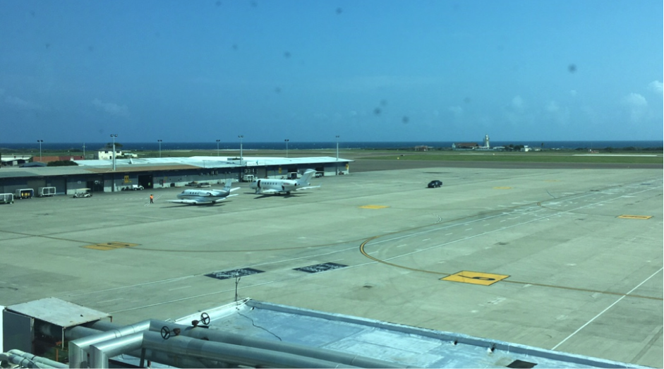
Jamaica - 2.2.1 Norman Manley International Airport
Airport Overview
The Norman Manley International Airport (NMIA) is one of Jamaica’s global gateways and is reputed to be the busiest airport for business travel. It also borders the Kingston Harbour.
Norman Manley International Airport is owned by the Government of Jamaica and operated by PAC Kingston Airport Limited (PACKAL) since October 10, 2019. Under the Airports Authority Act of 1974, the Airports Authority of Jamaica (AAJ) remains the authority on all aerodromes. PACKAL, a wholly owned subsidiary of Grupo Aeroportuario del Pacifico (GAP), based in Guadalajara, Mexico, operates and maintains the airport under a 25-year concession agreement signed in November 2018.
The airport’s business network is comprised of over 70 companies and government agencies, with over 3,500 people directly employed at the airport.
|
Airport Location and Contact |
|
|---|---|
|
Country |
JAMAICA |
|
Province or District |
ST. ANDREW |
|
Nearest Town or City |
KINGSTON |
|
Airport’s Complete Name |
NORMAN MANLEY INTERNATIONAL AIRPORT |
|
Latitude |
17° 56' 08.40" N |
|
Longitude |
076° 47' 15.00" W |
|
Elevation (ft and m) |
10 feet 3 meters |
|
IATA Code |
KIN |
|
ICAO Code |
MKJP |
|
Managing Company or Airport Authority |
Grupo Aeroportuario del Pacifico S.A.B De C.V. (GAP) |
|
Management Contact Person |
Mr. Richard Gibbs |
|
Open From (hours) |
0:00 HRS |
|
Open To (hours) |
24:00 HRS |
Airport Picture


Description and Contacts of Key Companies
Company Telephone
Airlift Handlers Ltd 1-876-924-8434
Airways International 1-876-924-8269
AJAS Ltd 1-876-924-8092
Jamaica Dispatch Services 1-876-924-8500
Worldwide Flight Services 1-876-924-8630-1
For more information on airport contacts, please see the following link: 4.5 Jamaica Airport Companies Contact List
Information on some aviation service providers can be found at: http://www.azfreight.com/
Passenger and Cargo Performance Indicator
The Norman Manley International Airport plays a critical role in the economic development of Jamaica, and is the premier gateway to the nation's capital, Kingston. The airport caters to over 1.7 million passengers, with an approximate 4% average growth rate. It handles over 70 percent (17 million kgs) of the island's airfreight.
|
Performance for 2019 |
|
|---|---|
|
Per Year |
|
|
Total Aircraft Movements |
22,345 |
|
Total Passengers |
1,862,235 |
|
Total Capacity of the Airport (MT) |
12,527 |
|
Current Activity of the Airport (MT) |
|
|
Current use by Humanitarian Flights (UNHAS) |
No |
Runways
|
Runway #12/30 |
|
|---|---|
|
Runway Dimensions |
8910 x 150 feet 2716 x 46 meters |
|
Orientation |
112.0 |
|
Surface |
Asphalt |
Runway #12/30 has one parallel taxiway with four linked taxiways, including one high-speed exit, competitive ground handling and fueling services.
Helicopter Pad(s)
|
Helipad #1 |
|
|---|---|
|
Present |
NO |
|
Largest Helicopter that can Land |
N/A |
|
Width and Length (m) |
N/A |
|
Surface |
Asphalt |
Airport Infrastructure Details
|
Customs |
YES |
JET A-1 fuel |
YES |
|---|---|---|---|
|
Immigration |
YES |
AVGAS 100 |
|
|
Terminal Building |
YES |
Single Point Refueling |
YES |
|
Passenger Terminal |
YES |
Air Starter Units |
N/A |
|
Cargo terminal |
YES |
Ground Power (mobile) |
N/A |
|
Pax Transport to Airfield |
YES |
Ground Handling Services |
YES |
|
Control Tower |
YES |
Latrine Servicing |
YES |
|
Weather Facilities |
YES |
Fire Fighting Category (ICAO) |
YES |
|
Catering Services |
YES |
De-icing Equipment |
YES |
|
Base Operating Room |
YES |
Parking Ramp Lighting |
YES |
|
Airport Radar |
N/A |
Approach & Runway Lights |
YES |
|
NDB |
N/A |
VOR |
|
|
ILS |
YES |
Airport Operating Details
|
Operating Details |
|||
|---|---|---|---|
|
Maximum Sized Aircraft that can be Offloaded on Bulk Cargo |
Antonov AN 124 |
||
|
Maximum Sized Aircraft that can be Offloaded on Pallet |
Antonov AN 124 |
||
|
Total Aircraft Parking Area (m²) |
|||
|
Storage Area (m3 and MT) |
|||
|
Handling Equipment |
|||
|
Elevators / Hi Loaders |
YES |
Max Capacity (MT) |
N/A |
|
Max Height (m) |
N/A |
||
|
Loading Ramps |
YES |
||
|
Other Comments |
N/A |
||
Customs Guidance
For more information on customs in Jamaica, please see the following link: 1.3 Jamaica Customs Information
Storage Facilities
Airfield Costs
FUEL SERVICES CHARGES
Jet A1, without icing inhibitor.
100/130 MIL Spec, low lead, aviation gasoline (BLUE).
|
Price per Litre USD - $ |
|
|---|---|
|
Jet A-1 |
$2.10/gal |
|
Avgas |
$6.50/gal |
Jamaica - 2.3 Road Network Assessment
Road Overview
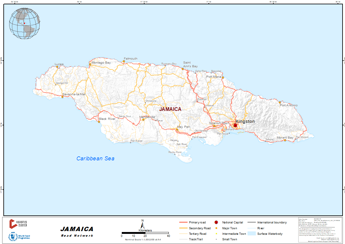
Jamaica's main road network consists of approximately 5000 km of class A, B and C roads. This network forms 19% of the total road surface available to a nation which relies almost exclusively on roads as the means of moving around the island. More than 90% of the main road network is paved. Jamaica also has 736 bridges on its main road network.
There are also parochial roads (14,895 km), farm roads (1,500 km) and community roads (4,200 km).
For more information on government contact details, please see the following link: 4.1 Jamaica Government Contact List
Distance Matrix
|
Distances from Capital City to Major Towns (km) |
||||||||
|---|---|---|---|---|---|---|---|---|
|
Kingston |
Portmore |
Spanish Town |
Ocho Rios |
Montego Bay |
Port Antonio |
Savanna-la-Mar |
Mandeville |
|
|
Kingston |
13 km |
21 km |
82 km |
183 km |
89 km |
195 km |
95 km |
|
|
Portmore |
13 km |
14 km |
79 km |
175 km |
101 km |
188 km |
93 km |
|
|
Spanish Town |
21 km |
14 km |
113 km |
159 km |
103 km |
175 km |
77 km |
|
|
Ocho Rios |
82 km |
79 km |
113 km |
100 km |
98 km |
148 km |
100 km |
|
|
Montego Bay |
183 km |
190 km |
158 km |
100 km |
200 km |
50 km |
105 km |
|
|
Port Antonio |
87 km |
98 km |
103 km |
98 km |
196 km |
252 km |
180 km |
|
|
Savanna-la-Mar |
195 km |
188 km |
175 km |
148 km |
50 km |
252 km |
103 km |
|
|
Mandeville |
93 km |
13 km |
77 km |
100 km |
105 km |
180 km |
103 km |
|
|
Travel Time from Capital City to Major Towns (Hours and Minutes) |
||||||||
|---|---|---|---|---|---|---|---|---|
|
Kingston |
Portmore |
Spanish Town |
Ocho Rios |
Montego Bay |
Port Antonio |
Savanna-la-Mar |
Mandeville |
|
|
Kingston |
25 m |
40 m |
2 hr |
3 hr 30 m |
2 hr 25 m |
3 hr 15 m |
1 hr 30 m |
|
|
Portmore |
25 m |
22 m |
1 hr 40 m |
3 hr 15 m |
2 hr 30 m |
3 hr |
1 hr 25 m |
|
|
Spanish Town |
40 m |
22 m |
1 hr 15 m |
2 hr 55 m |
2 hr 30 m |
3 hr |
1 hr 15 m |
|
|
Ocho Rios |
2 hr |
1 hr 40 m |
1 hr 15 m |
1 hr 45 m |
2 hr |
2 hr 45 m |
2 hr 25 m |
|
|
Montego Bay |
3 hr 30 m |
3 hr 15 m |
2 hr 55 m |
1 hr 45 m |
3 hr 40 m |
1 hr 15 m |
2 hr 40 m |
|
|
Port Antonio |
2 hr 25 m |
2 hr 30 m |
2 hr 30 m |
2 hr |
3 hr 40 m |
4 hr 45 m |
3 hr 30 m |
|
|
Savanna-la-Mar |
3 hr 15 m |
3 hr |
3 hr |
2 hr 45 m |
1 hr 15 m |
4 hr 45 m |
2 hr |
|
|
Mandeville |
1 hr 30 m |
1 hr 25 m |
1 hr 15 m |
2 hr 25 m |
2 hr 40 m |
3 hr 30 m |
2 hr |
|
Road Security
Security in Jamaica is generally good, with few incidents. The UN has an appointed UNDSS office with a security officer who liaises directly with local police units; this contact will make arrangements with them to provide security escorts.
2.4 Jamaica Railway Assessment
Railway Overview
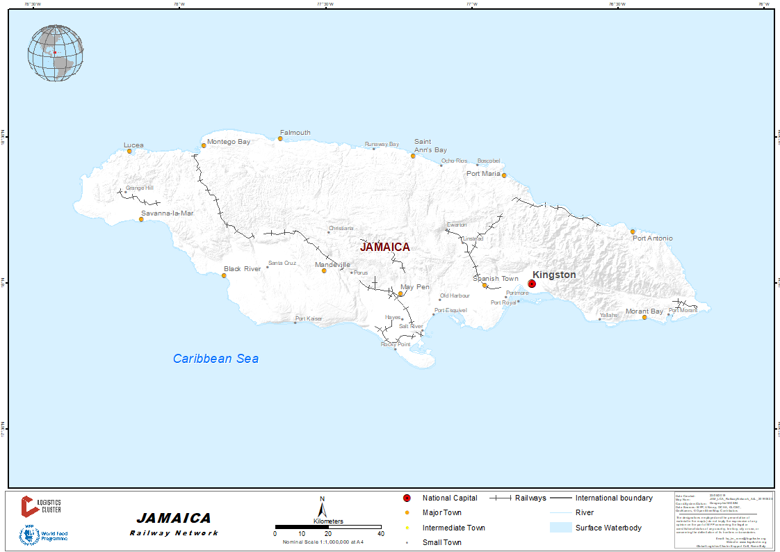
The public passenger railway service in Jamaica was closed in October 1992, briefly revived in 2011, and closed again in 2012. The railway system is currently used by a private-public joint partnership with limited tracks majorly used for exporting bauxite and sugar cane.
For more information on government contact details, please see the following link: 4.1 Jamaica Government Contact List
Railway Companies and Consortia
The Jamaican Railway Corporation (JRC) manages property and locomotives maintenance as part of a 30-year agreement with Windalco (West Indies Alumina Company), signed in November 1990.