Ecuador - 2 Logistics Infrastructure
Overview
In August 2020, Ecuador's exports were mainly from Guayaquil-Marítimo ($ 915M), Quito ($ 376M), Puerto Bolívar ($ 52.6M), Tulcán ($ 40.7M), and Guayaquil-Air ($ 39M), while The import destinations were mainly Guayaquil-Marítimo ($ 663M), Manta ($ 158M), Quito ($ 155M), Tulcán ($ 63.9M), and Guayaquil-Air ($ 58.4M).
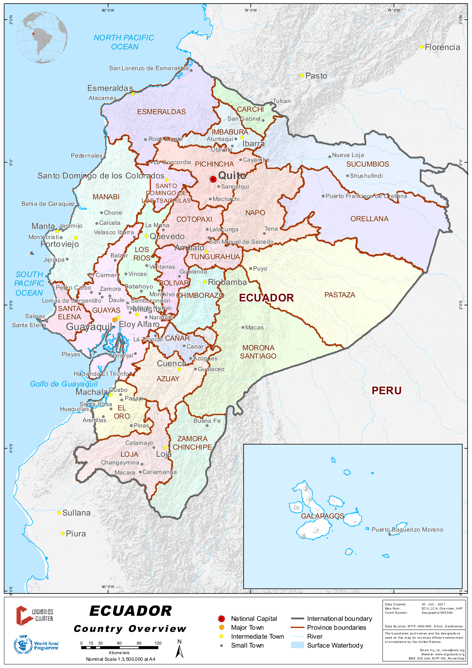
The Ecuadorian Institute for the Promotion of Exports and Investments Proecuador, an entity of the Ministry of Foreign Trade and the Ministry of Transport and Public Works, consider the macro logistics infrastructure is based on the following strategical assets: 10 renovated airports and 13 operating at the level national, of which 4 are international.
The port system made up of seven state ports and ten private docks, specialized in general cargo and oil, the main ones are: Guayaquil, Manta, Bolívar. River Transportation: Ecuador has several navigable rivers, such as: El Guayas and El Río Napo, which is a waterway that is part of the Manta-Manaus project. Ecuador has more than 966 km. of tracks state railways, join Sierra and Costa and is mainly used for tourism purposes.
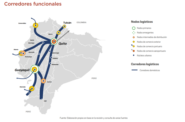
Ecuador's logistics structure would be set up of the following systems:
- National primary node: dominates the logistics of the country. Guayaquil and Quito.
- Quito logistics node: this central area has established a set of logistical relationships with the rest of the country's areas. The Quito airport it is the one that mobilizes most of the exports.
- Guayaquil logistics-port node: concentrates an important manufacturing base in the country. In addition, it channels the flow of maritime foreign trade, since it is the only port of the country that moves containers of relevant way.
- Intermediate distribution nodes: as intermediate domains between the primary nodes and secondary. Cuenca and Manta.
- Foreign trade nodes: ports, airports and border centers with stable trade flows and significant as sustained volume of operations.
- National logistics area: the most powerful logistics relationships in the country are structured from the coast to the mountains, between Guayaquil and Quito, encompassing Cuenca, in the inter-Andean valley of the southern Ecuadorian highlands.
- Secondary logistics areas: they are headed by Quito and the urban centers of Latacunga, Ambato, Santo Domingo de los Tsáchilas and Ibarra. Manta, together with Guayaquil and Machala, make up a logistics area, as do the Cuenca nodes and Loja.
- National corridors: The most representative corridor is the Quito-Guayaquil connection for the exchange of merchandise and its interrelation with foreign trade nodes.
- North-South Corridor: structures the country through the Andean highlands and links Macara (border with Peru) with Tulcán (border with Colombia), connecting Quito with the two neighboring countries.
Source: https://scioteca.caf.com/
Logistics Performance Index (LPI)
Ecuador is ranked 62 in the world (167 listed countries), surpassing Peru (83) and Venezuela (142), but below Colombia (58) and Chile (34), surpassing its neighboring countries in efficiency in its customs clearance processes and quality of Infrastructure. In 2018, Ecuador was ranked 70*.
The World Bank, Maritime Connectivity Index.
In the last publication, Ecuador decreased its index in relation to the previous year, despite the fact that experienced significant growth in 2016 compared to the previous period. However, the country is below Colombia, Chile and Peru, which indicates that Ecuadorian exporters have less cargo capacity for export in ships, and is reflected in higher transportation costs not being able to take advantage of economies of scale.
(*) https://lpi.worldbank.org/international/aggregated-ranking
Despite the advances in investment in recent years, Ecuador continues to have deficits in specialized logistics infrastructure. The country requires progress in investment in road and chain support infrastructures productive, commercial networks and diversified offer of value-added logistics services. The cost of logistics is one of the main problems for the country's exports; this is due to the fact that small business units in the logistics and transport sector are the ones that predominate.
The national structuring road axis is represented by the Carretera Panamericana, 1,400 km long, which crosses the country from north to south, joining Quito with Tulcán (border with Colombia) and Macará (border with Peru). The country suffers from a network of secondary roads and tertiary conditions for cargo transportation. This situation is trying to be mitigated with actions promoted by the Ministry of Transport and Public Works.
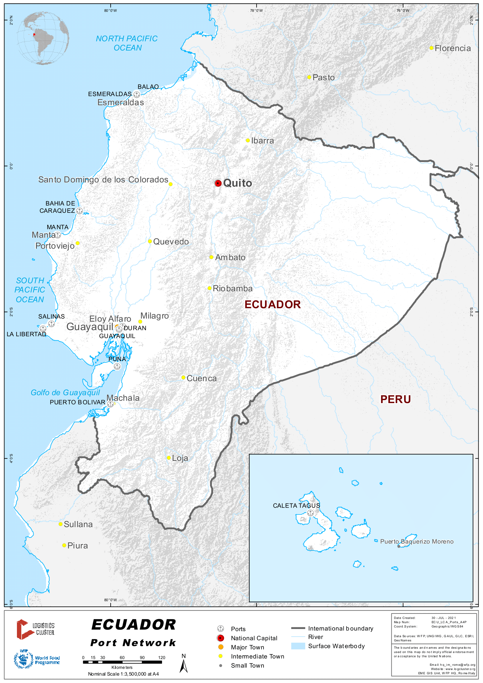
Ecuador has four port areas, all them located in the Pacific, while the river ports are positioned in the Amazon area of the country, on the banks of the main rivers. The Port of Guayaquil, in the province of Guayas, is the one with the largest cargo movement in the country
Air cargo is based mainly on the export of flowers. Quito airport concentrates 90% of this traffic. The logistics of exporting flowers as a single commodity could be considered as a handicap to the good positioning of this national product abroad, since there is an imbalance between exports and imports.
The infrastructure of the railway network is not ready for transport of goods. Its development has been practically null in recent years, despite the fact that it originally constituted the best means of transport and the main means of communication between the inner lands and the coast.
World Bank “Doing Business” Ecuador Ranking in 2020
Presented by Federación Ecuatoriana de Exportadores- FEDEXPOR
Ecuador is in position 129 out of 190 economies, with a score of 57.7, worsening its performance in the ease of doing business compared to 2019, even its score is lower than the average for Latin America and the Caribbean which is 59.1. In addition, the average recorded in the high-income economies of the Organization for Economic Cooperation and Development (OECD) is 78.4.
In Ecuador, the time to export is 96 hours, taking into consideration border compliance that includes obtaining, preparing and presenting documents during handling at ports or borders, customs clearance and inspection procedures. Additionally, the average cost (border compliance) to export in Ecuador is $ 560 dollars.
With respect to the region, Ecuador is above the average in terms of hours to export, since in the region the average is 55.3 hours, evidencing a great need to improve processes that facilitate trade and mainly exports.
Source: https://www.fedexpor.com/doing-business-ecuador-2020/
The Logistics Profile of Ecuador
Developed by the Latin American Development Bank “CAF” (former: Corporación Andina de Fomento) includes Ecuador's strategic vision, ambitions and logistics role, establishing a line of advance in the country's strategic ambitions**, which for Ecuador would consist of advancing from the current Level 1.1, which means: effective national logistics with the current production profile, at Level 1.2 in the short and medium term: efficient national logistics with greater added value and at Level 2.1 in the long term: logistics capacities to attract trade traffic from third countries, a subregional integrating axis between the two oceanic slopes.
(**) https://www.caf.com/en/currently/news/2019/02/ecuador-promotes-a-roadmap-for-the-logistics-sector/
Ecuador - 2.1 Ports Assessment
Overview
Every country on the west coast of South America except Ecuador has ports with draft of 15-16 metres, capable of handling fully laden 12,000-15,000 TEU vessels. This is despite the fact that Guayaquil is the second largest import-export port in South America after Santos, but has a draft of less than 10 metres plus a vessel length restriction of 305 metres.
Ecuador is a maritime country by nature. 90% of the commercial flow takes place by maritime transport, which makes its ports and maritime terminals an extremely important vector for the attraction and distribution of goods. Although the state port system in Ecuador is multipurpose, there is some specialization due to its infrastructure and organization, around different types of merchandise.
Ecuador borders the Pacific Ocean and has three principal ports in:
Guayaquil: Specialized in the export of bananas and containerized cargo. 20% of imported cargo comes from Argentina, Brazil, USA and Mexico.
Manta: with 92% of the port's activity based on imports. Bulks stand out (67% of the total mobilized cargo). The countries of origin or destination of the cargo mobilized from this port are the USA, Canada, Peru, Argentina and Colombia.
Esmeraldas: Multipurpose port that handles five types of cargo: general; containerized, liquid, solid and self-propelled vehicles. In 2020, cargo with the most important movement ratios were palm oil, containers and wire rod, with a participation in the total movement of 27%, 24% and 16% respectively.
Regarding the enabled port terminals, there are 11, notably Bananapuerto, Fertisa and Fertigran, all operating in Guayaquil. These three terminals encompass around 83% of the imports and exports of the total cargo moved in the eleven terminals. About 51% of imports and 92% of Exports carried out in authorized port terminals are carried out by containerized cargo.
The control of the load is carried out by means of a software called Terminal Management System which permanently verifies and provides complete information about the location and condition of the load. The standards of protection of the ports are certified according to the International Ship and Port Facility Protection Code through the Under Secretariat of Maritime Transport and Ports.
Port of Guayaquil
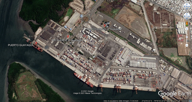
The 95-hectare port of Ecuador is the most relevant in the nation as it is responsible for 90% of the commercial flow that directly affects the national economy and the main port that connects with the capital city. Its strength is the purchase - sale of inputs, articles and chemical materials from foreign trade, its location is in the Gulf of Guayaquil, 50 nautical miles from the Pacific, making it an attractive port of Ecuador for investors. Although experts assure that it has possibilities of expansion it needs an improvement in its physical conditions because during low tide the ships take up to 6 hours to go out to the open sea.
Posorja Deepwater Port (Guayaquil Area)
The deep waters of Posorja Port is delegated by the Guayaquil Port Authority (APG) to the DP World Posorja Company. During the first operational year DP World Posorja has received 180 vessels. In addition, Neo-Panamax vessels have sailed for the first time in Ecuadorian waters at their maximum capacity, through the new access channel with characteristics that are 16.5 meters deep and 175 meters wide.
Main Characteristics
Terminal: 480 meter pier, 750,000 TEU annual capacity, 4 Quay Cranes, 15 RTG.
Access Road: A 20 km road that connects the terminal with the main motorway network, which will allow an expeditious, orderly and safe access route to the port.
Access Channel: A new and safer channel 16.5 m deep and 21 nautical miles long. The navigation channel will allow to occupy the maximum cargo capacity of Post Panamax type ships and larger ships that cross the Panama Canal, with a length of up to approximately 400m and a draft of 16m, with a cargo capacity of up to 15 thousand 40-foot containers .
Logistics area: Direct connectivity with the deep water port of Posorja. 100 hectares of land available.
Posorja Deep Water Port, Google Earth
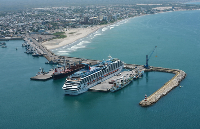
Port of Manta
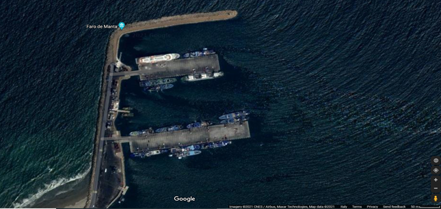
It is the best port in Ecuador in terms of infrastructure. It has 4 berths and 15 meters deep in the dock, allowing easy entry to maritime vessels. Its traffic is based on commercial vessels, fishing vessels and tourist cruises, because the port connects with the most important regions of Ecuador. The products that are unloaded are of any kind, from vehicles to bulk items in the 1,200 meters of the port. Although most are transfer, that is, they are like a stopover for transfer to other countries.
Source: Bianca Schröder, ecuatraveling.com
Port of Esmeraldas
Source: El Oficial, Puerto de Esmeraldas, https://eloficial.ec/
Its location in the Pacific Ocean in the north of Ecuador a few kilometers from Colombia allows it to easily load and unload supplies for the port city thanks to the maritime traffic of the neighboring country and other foreign connections. Unlike other ports, this one contains a closed circuit that offers merchants the possibility of better security and surveillance standards for companies that wish to store their containers.
Ecuador - 2.1.1 Port of Esmeraldas
Port Overview
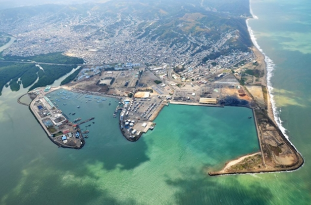
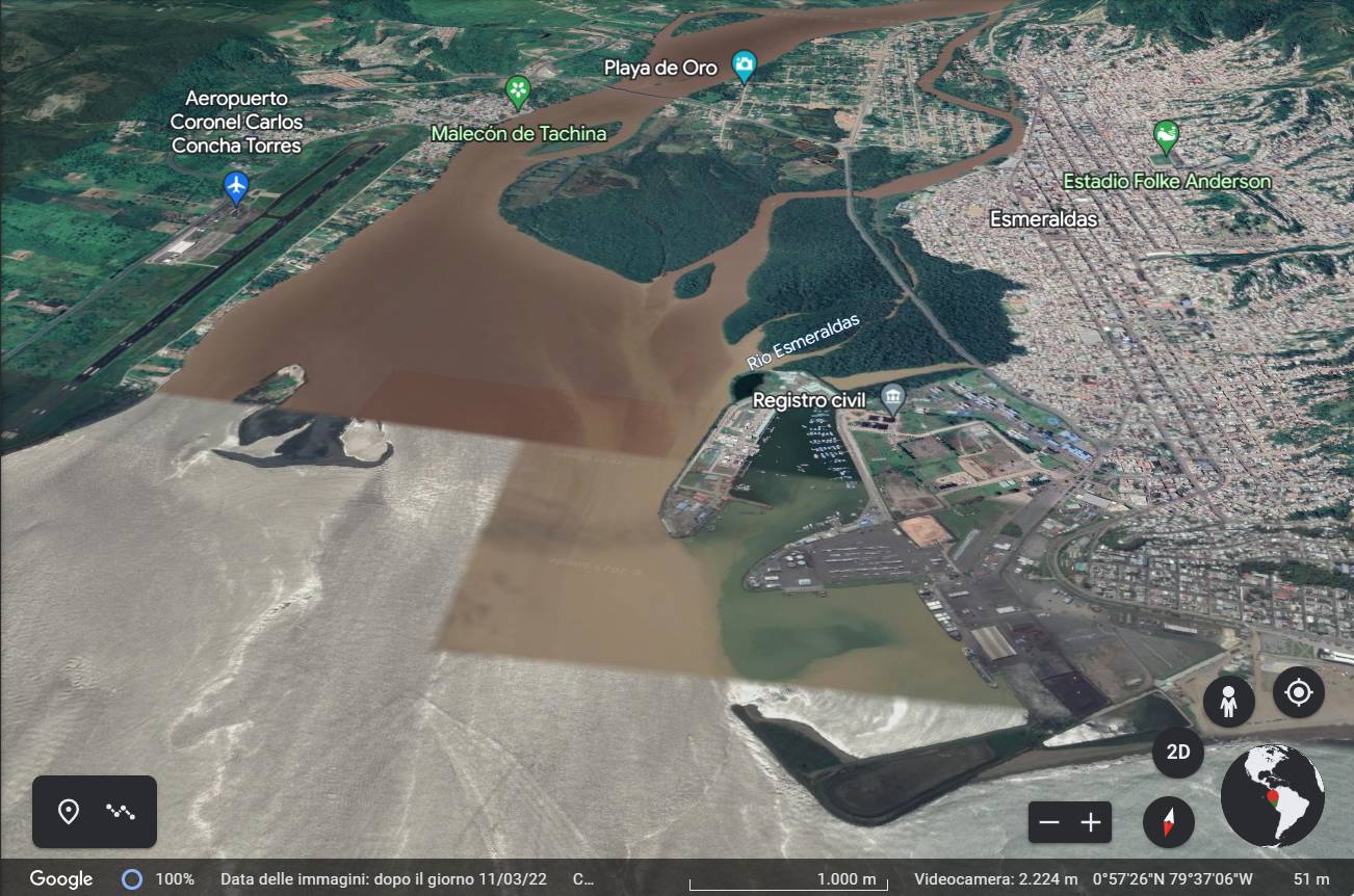
This port is located in the northwest of Ecuador at the mouth of the Esmeraldas River.
From its privileged position, it has occupied the position of main export center for wood, agricultural resources and other products. It is also the terminal of the Trans-Ecuadorian pipeline that transports oil from the oil fields in the northeast of the country. It is located in the northern part of Ecuador in the Province of Esmeraldas, next to the mouth of the river of the same name.
It stands out for being a multipurpose port, with direct access from the open sea, sheltered in a 32-hectare dock, which has protection of two breakwaters, which prevents the port from being affected by storm surges, which allows great manoeuvrability and docking of ships, and which also has qualified towing and pilotage services.
Its management is in charge of the Esmeraldas Port Authority, as a commercial and fishing port. The average annual temperature is 25.6 °C. With (738 mm of average annual rainfall producing its maximum in January, February and March. The prevailing winds are W and NW.
The Puerto de Esmeraldas has the following characteristics and services:
• Infrastructure and equipment for handling project-type loads.
• Operational flexibility and administrative efficiency
• Comprehensive security: port qualified with the International Ship and Port Facility Security Code (ISPS), Zero Theft and the Business Alliance for Secure Commerce (BASC) Certification, in the process of ISO 9,000 and 28,000 certification.
• Electricity and drinking water service 24 hours a day
• Customs agility.
• Regular lines with easy connections to the whole world.
• Proximity to the main industrial and commercial centres of the country.
• Communication routes in optimal condition and alternate routes.
• Personalized attention 24 hours a day, 365 days a year.
Facilities
It has two 200-meter long breakwater docks with the capacity to receive 4 vessels simultaneously, that is, 800 linear meters of berths for the operation of container ships, bulk carriers, carts, fishing vessels and cruise ships. Both docks have a platform width of 45 meters each. It also has another 620 linear meters for exclusively fishing and cabotage activities. Its dock has 110 hectares protected by a breakwater that allows for quick and comfortable arrival, loading and unloading of vessels.
Storage: It has 120,980 m2 (twelve hectares) for storage, between patios and a covered warehouse.
Access: Access to the Port is direct from a natural depression in the seabed that reaches up to 200 meters from the port entrance. The area where the docks are located is protected by breakwaters, which frame a 42-hectare basin.
Puerto website: http://www.puertoesmeraldas.gob.ec/
Key port information may also be found at: http://www.maritime-database.com
|
Port Location and Contact |
|
|---|---|
|
Country |
Ecuador |
|
Province or District |
Esmeraldas |
|
Nearest Town or City with Distance from Port |
Esmeraldas (4 km) |
|
Port's Complete Name |
Puerto de Esmeraldas |
|
Latitude |
0.994167 |
|
Longitude |
-79.64444 |
|
Managing Company or Port Authority
|
Autoridad Portuaria Esmeraldas |
|
Management Contact Person |
Ingº Fernando Xavier Moncayo Raad – General Manager - Autoridad Portuaria de Esmeraldas gerencia@puertoesmeraldas.gob.ec Teléfonos: 062 715757 062 721354 jefedeoperaciones@puertoesmeraldas.gob.ec Tel. 062 722367 Ext.:463-464 Atención al Cliente y Comercialización acliente@puertoesmeraldas.gob.ec ssimbana@puertoesmeraldas.gob.ec Tel. 062 721354 Ext.:470-471 comunicacionsocial@puertoesmeraldas.gob.ec Tel: 062 721354 Ext: 472-473
|
|
Nearest Airport and Airlines with Frequent International Arrivals/Departures |
Aeropuerto Internacional Coronel Carlos Concha Torres |
Port Picture
Description and Contacts of Key Companies
|
Company |
Services |
Telephone |
Email Address |
|---|---|---|---|
|
INTERTEK INTERNACIONAL LIMITED |
Inspection |
042687180 |
|
|
PROVEEDORES MARÍTIMOS LOZADA CHAVEZ & ASOCIADOS |
Water and nursery provision |
062721355 062728111 |
|
|
COTECNA DEL ECUADOR |
Cargo Inspection |
042523723 |
|
|
ZAMARINO S.A |
Berth cleaning |
62727974 |
|
|
MARDCOMSA |
Supply of fuel, lubricants and water per vessel |
52626443 |
|
|
SUMATRA |
Piloting |
042599175 42136177 |
|
|
CONTROL INTERNACIONAL DEL ECUADOR C.A. |
Cargo inspection |
2443602 2446689 |
|
|
SOUTH AMERICAN MARINE ENGINEERING & SERVICES SOUTHA S.A |
Maintenance of vessels and equipment, provision of supplies, provision of nurseries |
046002160 042103659 |
|
|
PARCESHI S.A. |
Vessel fuel supply |
042283158 042396495 |
|
|
TRIESTISA |
Stowing, re-stowing and de-stowing |
062715425 |
For more information on port contacts, please see the following link: 4.4 Port and Waterways Companies Contact List.
Port Performance
In the western port area, there are extensive facilities for loading and unloading fuel oil, gasoline, diesel and kerosene. Primary exports consist of bananas and wood, while main imports are pipes, machinery and steel billets. The port has capacity for ships weighing between 40,000 and 100,000 deadweight tonnage (DWT). There is a Free Zone that houses companies and shipping companies adjacent to the port facility.
Access cannel
General characteristics Access to the port terminal is almost directly from the sea. Latitude: 01°01' 45''North (N) Longitude: -79°39'6''West (W).
The access channel has the following characteristics:
From the sea buoy 2 miles to the entrance to the pier. Width: 200 meters. (656.2 feet) - Depth: 11.5 m. (37.8 feet) Average tide width at the entrance: 1.80 m. Average width of the tide at the foot of the pier: 3.80 m.
Navigation aid systems
The channel has depths greater than 11.5 meters. Regarding the minimum level of low tides and allows quick and safe navigation, with an adequate navigation aid system. The tranquility of its waters and the excellent climatic conditions of the port guarantee its operation 365 days a year.
Bunker
Esmeraldas / Tepre has bunker available for the following grades: MGO at $1320.5 per ton, and the last price update was on Friday, August 11, 2023.
|
Seasonal Constraints |
||
|---|---|---|
|
|
Occurs |
Time Frame |
|
Rainy Season |
Yes |
From December to March, although this can vary constantly. |
|
Major Import Campaigns |
No |
|
|
Other Comments |
The tranquillity of its waters and the excellent climatic conditions in the port area guarantee its operation 365 days a year. |
|
|
Handling Figures for 2022 |
|
|---|---|
|
Vessel Calls |
Docking of 33 vessels in the first four months of 2022, compared to the 15 vessels entered in the same period in 2021. (Comparative note: 2012, 312 vessels, 2013 294 vessels, 2014 256, 2019 142 vessels.) |
|
Container Traffic (TEUs) |
N/A
(Max. Cap. Installed in port-terminal relationship 850 TEU's) |
|
Handling Figures Bulk and Break Bulk for 2022 |
|
|---|---|
|
Bulk (MT) |
Liquid bulk occupied the number one position in “type” of manoeuvre cargo (Palm and Soybean oil) with 92,000 MT. Exports, mostly coconut oil, have reached 25,991 tons, exceeding the 14,315 tons recorded in January to April in 2021 Others, Solid bulk (PetCoke and Scrap) with 83,000 MT |
|
Break bulk (MT) |
Carga total en importación y exportación de 134 339 toneladas hasta abril 2022. |
Discharge Rates and Terminal Handling Charges
For information on port rates and charges, visit: Puerto de Esmeraldas website. http://www.puertoesmeraldas.gob.ec/
Berthing Specifications
It has a 200 m long breakwater, a 350 m long general cargo dock and a 185 m long container dock with a depth of 11 m. An additional dock accommodates fishing boats and barges and carries out cabotage activities.
|
Type of Berth |
Quantity |
Length (m) |
Maximum Draft (m) |
Comments |
|---|---|---|---|---|
|
Conventional Berth |
1 |
350 |
11 |
|
|
Container Berth |
2 |
185 |
10 |
|
|
Silo Berth |
No |
|
|
|
|
Berthing Tugs |
2 |
|
|
Two azimuthal stern drive (ASD) tugs from Damen Shipyards to support oil tankers and other vessels entering port. |
|
Water Barges |
Yes |
|
|
General Cargo Handling Berths
|
Cargo Type |
Berth Identification |
|---|---|
|
Imports - Bagged Cargo |
Yes |
|
Exports - Bagged Cargo |
Exports, mostly of coconut oil, have reached 25,991 tons, exceeding the 14,315 tons recorded from January to April in 2021. |
|
Imports and Exports - RoRo |
Imported 5,416 units of vehicles, vehicle cargo with 27,000 MT (cars and machinery) [Comparative note: in 2018 more than 11,000 vehicles were imported] |
|
Other Imports |
Containers, general cargo, liquid and solid bulk, vehicles, pipes, spare parts, CKD, iron, steel, oil equipment and iron scrap. |
Port Handling Equipment
|
Equipment |
Available
|
Total Quantity and Capacity Available |
Comments on Current Condition and Actual Usage |
|---|---|---|---|
|
Dockside Crane |
No |
|
|
|
Container Gantries |
No |
|
|
|
Mobile Cranes |
Yes |
1 DEMAC AC-400,
1 DEMAC crane super transporter for AC-400 1 Terex x 80 ton |
Only for patio manouvres 0-24 Ton Lifts, 25-49 Ton Lifts, 50-100 Ton Lifts |
|
Reachstacker |
Yes |
1 x 45 ton, 1 x 10 ton, 2 toploaders x 40 ton, 1 Terex x 45 tons |
Hyster, Terex, operational
For loading full container and empty container. |
|
RoRo Tugmaster (with Trailer) |
Yes |
21 |
20 meter long Roll-on Roll-off dock for rolling loading and unloading located adjacent to the main dock |
|
Grain Elevator with Bagging Machines |
No |
|
|
|
Transtainer |
Yes |
5 x 40 tons |
Kodiak Chevrolet, operational, for container yard maneuvers. |
|
Forklifts |
Yes |
1 x 2.5 ton,1 x 3.5 ton, 1 x 7ton, 3 x 10 ton, 1 x16 ton, |
CPCD70, CPCD100, CPCD160A, CPQD25, CPCD3.5 |
Container Facilities
Currently, a container yard has been improvised in this port with an area of four hectares, without its own backup dock and using the system of equipment to handle ship-port containers, with the ships' own cranes for embarkation and disembarkation. tractor-trailer for movement, and reachstaker type front loaders for stacking in the storage area, which causes downtime and delay of the ship in port, as well as loss of efficiency in stacking due to the large manoeuvrability space. you need a reachstaker. To handle an appreciable volume of containers that the Port of Esmeraldas presents, the problems of dock congestion must be overcome.
|
Facilities |
20 ft |
40 ft |
|---|---|---|
|
Container Facilities Available |
Yes |
Yes |
|
Container Freight Station (CFS) |
Yes |
Yes |
|
Refrigerated Container Stations |
Yes |
Yes |
|
Other Capacity Details |
N/A |
N/A |
|
Daily Take Off Capacity |
252, total |
|
|
Number of Reefer Stations |
N/A |
N/A |
|
Emergency Take-off Capacity |
N/A |
N/A |
|
Off take Capacity of Gang Shift |
N/A |
N/A |
Customs Guidance
For import procedures, the following documentation/information will be required at the service windows of the Billing Department to obtain a gate pass:
The cargo number authorized by SENAE.
For procedures with SENAE authorizations through administrative acts, you must present a copy of the document.
Exit Authorization Letter (CAS) (Electronic or Physical)
Copy of the Bill of Lading (BL), for the cases of General Cargo and Loose Cargo
Information of the transport company, or name of the driver and license plate of the vehicle that will collect the load
This documentation will be required by the access control booths before access.
The gate pass may also be issued to the customs agent/assistant or other personnel authorized by the importer to carry out customs formalities.
The requirements of the “Port Security Manual for the Issuance of Credentials and Provisional Permits” must be met.
For cargo dispatch, warehouses have a scheduled delivery service with assigned shifts, taking into account the following aspects:
Depending on availability, the customer chooses the most convenient shift to pick up their load. Shifts include the earliest and latest pick-up times.
In the event that a client misses their turn (that is, does not arrive at the assigned time), it is possible to request another one the same day at the access control booths.
For cases of Direct Debit (DD) or Advance Clearance (DA), verify that the customs procedure has been authorized and the operation is scheduled in the Customer Service Department.
For more information on customs in ECUADOR, please see the following link: 1.3 Customs Information.
Terminal Information
MULTIPURPOSE TERMINAL
Multipurpose terminal, with direct access from the open sea, sheltered in a dock, which allows great manoeuvrability and docking of ships. Its geostrategic location is of importance in relation to the Asian markets, being equidistant from those of the South, Central and North America. It is a Multipurpose Port, the facilities facilitate access for all types of vessels, guaranteeing easy manoeuvring of vessels and loading, unloading and provisioning operations, as well as appropriate safety and mobility conditions for the arrival of cruise ships and tourists.
GRAIN AND BULK HANDLING
This medium-sized general and bulk cargo port is favourably positioned for shipping lumber, agricultural products, raw materials and consumer goods. It is the terminal of the trans-Ecuadorian oil pipeline linked to the oil fields in the northeast of the country. About 12 percent of the country's international trade is carried out through the port, with a total of 850,000 tons of cargo annually.
Since the port does not typically handle bulk grain, cargo must be bagged for storage or transported directly by truck out of the port (4 hoppers are available for loading loose grain onto trucks directly from the ship). The solid bulk cargo handled at the port is entirely non-food cargo: Import of steel pellets and crushed scrap and export of wood chips. All of this cargo is stored in open yard facilities.
MAIN STORAGE TERMINAL
It has 120,980 m2 (twelve hectares) for storage, including patios and a covered warehouse.
Storage capacity is limited, but it has not yet reached its end; However, large quantities of empty containers, stacked 4 high, occupy approximately 25% of the yard's total capacity. Two warehouses (7,200 m² and 1,500 m²) are currently used for the storage of steel coils and bags of cement. In an emergency, warehouses can be emptied and reused after intensive floor cleaning and roof repair.
There is ample storage space, including a 12-hectare paved area between the patios and the basement.
|
Storage Type |
Number of Storage Facilities |
Area (m2) |
|---|---|---|
|
Bagged Cargo |
1 |
1,500m2 |
|
Refrigerated Cargo |
N/A |
N/A |
|
General Cargo |
1 |
7,200m2 |
Stevedoring
The Esmeraldas Port Terminal offers the stowage and unloading service. The port has adequate equipment and material, duly certified, which guarantees safety and efficiency in cargo handling. Various types of cargo are handled such as containers, agricultural products, general cargo, vehicles, machinery and project cargo. The stevedoring operation is carried out by private companies, classified and regulated by the National Government. The list and ranking of operators is carried out according to the type of activities and services they provide to the terminals (cargo handling, pilotage, towing, dredging, port storage and other activities).
Hinterland Information
By landway:
The road conditions of access to the Esmeraldas province are regular. In case of interruption of access routes, the state intervenes with priority to restore light and heavy traffic to and from the port sector, however, there are possible rock falls, problems with unstable slopes and settlements on the road.
The Quinindé-Esmeraldas section, on the E-20 highway, has at least 28 critical points: sinkholes, cuts in the asphalt layer and collapsed sewers have become a risk for drivers who travel daily along the main access route to the capital. The Quinindé road is in poor condition, with a lack of signage and luminosity at night. The most critical area is located in the El Vergel area, where there is an undermining of the land, which has forced a variant of the road to be enabled to allow the passage of the nearly 18,000 vehicles that travel on this road every day.
On the “Y” highway of Tababuela – San Lorenzo – Esmeraldas – Pedernales, there is an activated geological fault in the San Gerónimo sector, between Salinas and Lita. The roads in the northern area will be monitored through the GPS system of the road patrols, which in case of emergencies will mobilize the necessary road equipment.
For more information on feasibility consult: ECU 911 Consult about ways
By sea:
Ecuador has implemented the maritime security requirements contained in Chapter XI-2 of the International Convention for the Safety of Life at Sea of 1974 and the International Ship and Port Facility Security Code (ISPS) through the Law of Merchant Marine of 2004 and the Maritime Safety Regulations of 2004. These regulations apply to all seaports in Ecuador and to passenger ships, cargo ships of 500 GRT or more and mobile offshore drilling units on international voyages.
Port Security
Comprehensive security: port qualified with the International Ship and Port Facility Security Code (ISPS), Zero Theft and the Business Alliance for Secure Commerce (BASC) Certification, in the process of ISO 9,000 and 28,000 certification. Security Level 1 applies in territorial waters and maritime ports of Ecuador. Any change in the level of security or its area of application will be communicated through notices to mariners, nautical advisories, circulars, VHF communication or any other appropriate means.
|
Security |
|
|---|---|
|
ISPS Compliant |
Yes |
|
Current ISPS Level |
1 |
|
Police Boats |
Yes |
|
Fire Engines |
Yes |
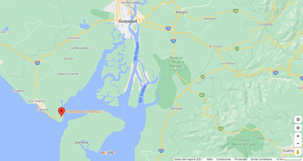
Ecuador - 2.1.2 Port of Guayaquil
Port Overview
According to the Undersecretariat of Ports and Maritime and River Transport, 85% of the country's non-oil cargo transfer is moved through the Port of Guayaquil through its public and private terminals.
There are two large groups of facilities: Sea Port, owned/managed by the Port Authority which has granted concessions to private operators, namely Contecon Guayaquil S.A. and Andipuerto, for 20 years; and Isla Trinitaria, which has attracted private operators to invest in port infrastructure. In the latter, three companies operate terminals directly next to each other: Terminal Portuario de Guayaquil (TPG), Terminal Portuario Bananapuerto operated by Aretina (the maximum draft for all terminals on Isla Trinitaria is 9.75 meters) and Puerto Trinitaria S.A. operating with: 1 dock 126 meters in length, dock draft: Up to 11.5 meters (high tide) 9.75 meters (low tide), Boat length: up to 250 meters, No. Berths: 2. The Fertisa Port Terminal offers refrigerated and bulk facilities; and the Ecuadoriana de Granos (Ecuagran) bulk terminal offers a berth directly over the Guayas River and inside the city. There are other private berth operators such as Molinos del Ecuador, Sepresa and Industrial Molinero along the Guayas River. All terminals have a single berth; Vessels may have a maximum length of 180 meters and a maximum draft of 6.5 meters.
Dredging work in the port access channel
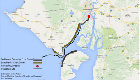
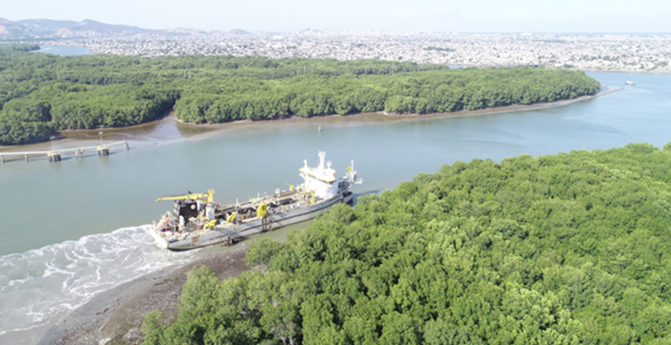
In January 2020, the Guayaquil Port Terminal (TPG) set a record in the port history of Ecuador and the region by receiving the largest ship to arrive at ports in Latin America. The arrival of the APL Esplanade ship marked the inauguration of the works to deepen the maritime access channel and the estuaries that connect the marine buoy with the port terminals. The dredging works were carried out by Canal Guayaquil, a subsidiary of the Belgian company Jan De Nul. , which will maintain the sea route for a 25-year contract. The company dredged the 92-kilometer channel and eliminated the Los Goles rocky area, which constituted an obstacle to navigation. The depth of the channel went from 9.5 meters to 12.5 meters and 13 meters, with tidal benefit
Canal Guayaquil S.A., responsible for the dredging work to deepen the access channel to the public and private maritime and river port terminals of the Main Port, completed the tasks. Deep draft ships enter the port of Guayaquil, through 12.5 and 13 meters of depth (with tidal benefit).
Port website: https://www.cgsa.com.ec/
Key port information may also be found at: http://www.maritime-database.com
|
Port Location and Contact |
|
|---|---|
|
Country |
Ecuador |
|
Province or District |
Guayas |
|
Nearest Town or City with Distance from Port |
Guayaquil (10 km) |
|
Port's Complete Name |
Puerto Marítimo de Guayaquil - Libertador Simón Bolívar |
|
Latitude |
-2.280833 |
|
Longitude |
-79.91361 |
|
Managing Company or Port Authority
|
Guayaquil Port Authority
Contecon Guayaquil S.A. exercises the administration and operation of the container and multipurpose terminal of the Maritime Port of Guayaquil
|
|
Management Contact Person |
Héctor Hugo Plaza Subía, Gerente de APG +593 4 2480120, +593 4 2012000 Lcdo. Jonatan Sotalin – Autoridad Portuaria de Guayaquil –- hernansotalin@apg.gob.ec |
|
Nearest Airport and Airlines with Frequent International Arrivals/Departures |
Aeropuerto Internacional José Joaquín de Olmedo
American Airlines, Avianca, Copa Airlines, Iberia, KLM, LAN, Air Europa, Latam, TACA, TAME, UPS |
Port Picture
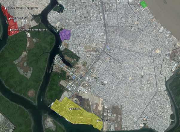
Legend
Yellow: Sea Port (Contecon Guayaquil S.A. and Andipuerto)
Red: Bananapuerto Port Terminal
Purple: Fertisa Port Terminal
Green: Ecuadorian Grains (Ecuagran)
Description and Contacts of Key Companies
|
Compañia |
Servicios |
Contacto |
Correo electrónico/ Website |
|---|---|---|---|
|
Andipuerto Guayaquil S.A. |
Multipurpose grain terminal, bulk |
|
|
|
Aretina |
Port Logistics Operator FCL, bulk, warehouse, container yard |
|
|
|
Contecon Guayaquil S.A. |
Port Terminal Operator |
+593 4 600 6300 |
|
|
DPWorld Posorja |
Port Operator, FCL |
+593 4 380 4850 |
|
|
Ecuaestibas S.A. |
Tugs, berthing |
+593 042 517 360 |
|
|
M&C Surveyors |
Consultancy and surveying services to the marine, commodities and insurance sectors |
+51947245898 |
|
|
Petrocomercial |
Fuel, bunkering, greases, oil products |
043803000 |
|
|
Puerto Trinitaria - Trinipuerto S. A |
Support Activities for Rail Transportation |
+593 4 269 7244 |
|
|
QC Terminales Ecuador |
Port Terminal, Bulk oil, chemical, warehouse |
|
|
|
Setmabas S.A. |
Ship services, technical support and supplies |
+593 4-202-8158 |
|
|
Terminal Portuario de Guayaquil TPG |
Port Terminal, FCL |
|
Port Performance
During 2022, the Guayaquil Port Terminal (TPG) for the fourth consecutive year was the port that registered the largest cargo movement in Ecuador
Export
Among the main products exported through the TPG are bananas, shrimp, wood and cocoa (representing 74%), whose main destinations were China, Chile, India, Japan, Argentina, and the United States.
Import
The goods that were imported in the greatest quantity were plastic items, vehicle parts, paper, books, food and products for its preparation, construction materials, paints and finishes.
In January 2020, Terminal Portuario Guayaquil (TPG) set a record in the port history of Ecuador and the region by receiving the largest ship to arrive at ports in Latin America. The arrival of the APL Esplanade ship, which has a length of 368.82 meters and a beam of 51 m, arrived at the Guayaquil Port Terminal thanks to the recent deepening of the docking dock. It marked the inauguration of the works to deepen the maritime access channel and the estuaries that connect the maritime buoy with the port terminals. The dredging works were awarded and carried out by Canal Guayaquil, a subsidiary of the Belgian company Jan De Nun, which will maintain the maritime route under a 25-year contract. The company dredged the 92-kilometer channel and eliminated the Los Goles rocky area, which constituted an obstacle to navigation. The depth of the channel went from 9.5 meters to 12.5 meters and 13 meters, with tidal benefit.
The Port Authority of Guayaquil, APG, through its concessionaires (Contecon1 and Andipuerto) and delegate (DP World Posorja), works 24 hours a day, seven days a week in the reception and dispatch of products.
-
Contecon reached the figure of 12 million TEUs moved since operations began at the Guayaquil seaport, Libertador Simón Bolívar (Container Terminal), which was in 2007.
|
Seasonal Constraints |
||
|---|---|---|
|
|
Occurs |
Time Frame |
|
Rainy Season |
Yes |
From December to March |
|
Major Import Campaigns |
No |
|
|
Other Comments |
The greatest historical limitation of the Port of Guayaquil is the limited water depth in access to its facilities. Canal Guayaquil S.A., responsible for the dredging work to deepen the access channel to the public and private maritime and river port terminals of the Main Port, completed the tasks. Deep draft ships enter the port of Guayaquil, through 12.5 and 13 meters of depth (with tidal benefit). |
|
Source: www.jandenul.com/projects/deepening-guayaquil-harbour-access-channel-ecuador
|
Handling Figures for 2022 |
|
|---|---|
|
Vessel Calls |
2700 deep draft ships with a capacity of 12,000 to 14,000 TEUS's
(Reference note: in 2019, 2,210 ships of different draft, of which, 804 ships docked at the terminals. 2021, 2,000 ships. 1,552 deep-draft ships and 658 cabotage operations ships |
|
Container Traffic (TEUs) |
488 thousand containers (20 and 40 feet) (Reference note: in 2019 823,951 thousand TEUs) |
During 2022, the Guayaquil Port Terminal (TPG) for the fourth consecutive year was the port that registered the largest cargo movement in Ecuador
|
Handling Figures Bulk and Break Bulk for 2022 |
|
|---|---|
|
Bulk (MT) |
The (public) Bulk Terminal, concessioned to Andipuerto Guayaquil S. A., moved 2,681,433 mt of bulk cargo. |
|
Break bulk (MT) |
The (public) Bulk Terminal, concessioned to Andipuerto Guayaquil S. A., moved 2,681,433 mt of bulk cargo. |
Discharge Rates and Terminal Handling Charges
CGSA continuously and permanently provides the following basic services:
• Use of the dock by ships (TMN)
• Full container transfer (TTC), ship to door
• General Cargo Transfer (TTG), Ship to door
• Banana Cargo Transfer (TTB), Door to ship
• Container storage (TAC)
• General Cargo Storage in Yards (AG1)
• Storage of Non-Container General Cargo in Warehouses (AG2)
• Storage of Non-Container General Cargo in Special Warehouses (AG3)
• Transfer of Empty Containers (TTV)
• Container Replacement (REE)
• Vehicle weighing (TPE)
• Container Consolidation/Deconsolidation (CFS)
• Connection and Feeding to Reefers (TRF)
• Capacity or Container Inspection Operations (AFC)
• 19
• Capacity Operations or Inspection of General Non-Containers
• Load (AFG)
• Container Shipping (TPC)
• General Cargo Shipping (TPG)
• Receiving / Dispatch Containers (RDC)
• Reception / Dispatch of General Cargo (RDG)
• Fee for use of tugboat facilities (TMR)
For more information on port rates and charges, consult the following links:
Port Services Manual Tarifas y Servicios Portuarios Version: 1.3 Date: 03/30/2023
Contecon Guayaquil (CGSA) “Port to Door” service
This is an automated cross-docking service that allows consignees to receive their cargo directly at their doorstep. Port to Door eliminates the need for shippers to go to the terminal to retrieve their shipment. The service offers an express option for same-day cargo delivery. The cost of the new service will vary depending on the volume of cargo and the distance between the port and the delivery location. Port to Door can be booked in advance before cargo arrives in Ecuador or while cargo is stored in port warehouses. Cargo can be transported as soon as it is unloaded from the ship. The Port to Door service will initially be available for clients based in Guayaquil via the perimeter and Durán, and will be expanded to cover more areas in the coming months. Shippers must log in to the CGSA website to access the service and can track their cargo in real time using the CGSAPP mobile application.
THC Shipping lines (only as an example)
Hapag Lloyd Terminal Handling Charges 2023 HALO THC Services fee 2023
CMA CMG THC Rate CMA CGM Local Charges 2023
Berthing Specifications
|
Type of Berth |
Quantity |
Length (m) |
Maximum Draft (m) |
Comments |
|---|---|---|---|---|
|
Conventional Berth |
|
600 |
10.5 |
Natural River Type Port. There is no good bottom for anchoring |
|
Container Berth |
|
1000 |
10.5 |
|
|
Silo Berth |
Si |
|
|
|
|
Berthing Tugs |
(4 units) 32.59 m, 27.81m, 22.5m, 32.10m |
|
|
Guayas II, Vinces, Macará, Chone. |
|
Water Barges |
N/A |
|
|
The Port of Guayaquil provides water service https://www.searates.com/port/guayaquil_ec
|
Dock allocation priorities
Docks 1, 1A, 1B, 1C and 2
1. Ships with a Dock reservation contract/agreement.
2. Ships with full container carriers.
3. Multipurpose Ships that transfer containers and general cargo.
4. Ships that transfer perishable products.
Piers 3, 4, 5 and 6
1. Vessels with dock reservation contract/agreement.
2. Vessels that transport perishable products.
3. Multipurpose vessels that transport containers and general cargo.
The following vessels will have preference for dock assignment:
1. Vessels on official visit.
2. Passenger/cruise ships.
Contecon Guayaquil CGSA pags, 21, 22
Concesionaria CONTECON Guayaquil S.A.
|
Pier |
Largo (m) |
Lenght(m) |
|---|---|---|
|
1 |
185 |
10 m |
|
1A |
185 |
10 m |
|
1B |
185 |
10 m |
|
1C |
145 |
10 m |
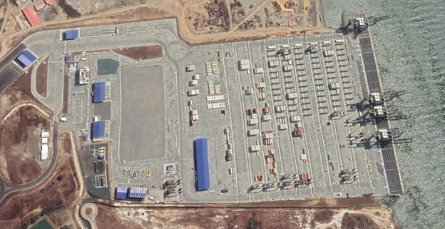
Port Terminal Guayaquil (TPG)
|
Access |
Canal Santa Ana |
|---|---|
|
Deep |
9.75 m |
|
Berth |
2, passenger, (Largo 360m) 2 |
|
Warehousing |
103,000 m2 |
|
Type of Cargo |
Only containers FCL |
|
Services |
Cntr, stuffing, Release, Conection Reefer |
|
Certifications |
ISPS Code, ISO 9001, BASC |
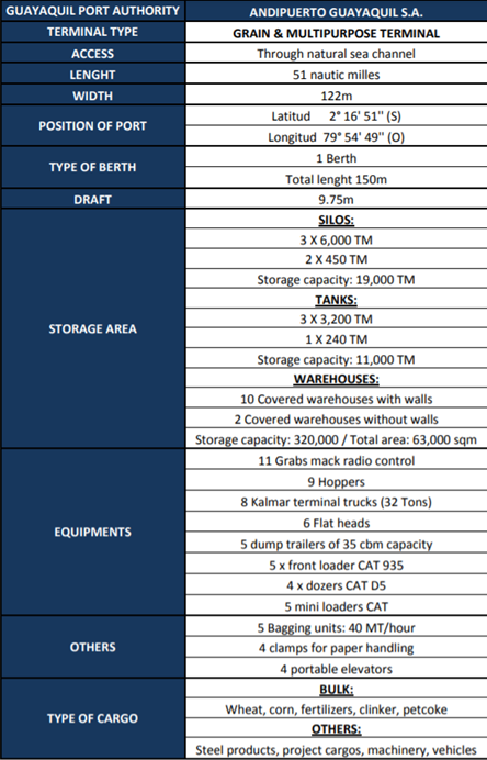
Andipuerto Guayaquil S.A. Grain & Multipurpose Terminal
|
Access |
Canal Natural Marítimo |
|---|---|
|
Deep |
9.75 m |
|
Berth |
1 (largo 150 m) |
|
Warehousing |
Silos, Tanks, Whse |
|
Tipo de Carga |
Grain, cement, ashes, petcoke, steel, oils, others |
|
Services |
Weight, Forklift, Warehousing |
|
Certifications |
BASC, ISPS Code, ISO 9001 |

Port Trinitaria, Trinipuerto S.A.
|
Access |
Canal Santa Ana |
|---|---|
|
Deep |
9.75 m |
|
Berth |
1 (largo 125 m) |
|
Warehouse |
14 grain warehouses up to 140,000 MT |
|
Type of Cargo |
Bulk, Cement, Ashes, Petcoke, Soya, Flour |
|
Servicios |
Sistema de Seguridad por circuito cerrado de tv, Sensores Magnéticos instalados. |
|
Certificación |
ISPS Code |
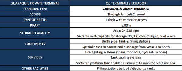
QC Terminales Ecuador Chemical And Oil-Chemical
|
Acceso |
Canal Jambeli |
|---|---|
|
Deep |
6.80 m |
|
Berth |
1 |
|
Warehousing |
Area 24,238 m2 - 56 Tanks |
|
Type of Cargo |
Chemical, Oil |
|
Services |
Operations Monitoring on Real Time Software, Tank Cooling |
|
Certification |
ISPS Code, ISO 9001 |
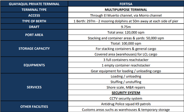
Fertisa Multipurpose Terminal
|
Access |
Canal El Muerto |
|---|---|
|
Deep |
9.75 m |
|
Berth |
1 (lenght 297 m) |
|
Warehousing |
100,000 m2 Containers, General Cargo |
|
Typo of Cargo |
Bananas, Fruits, Fertilizers bulk |
|
Services |
Load Unload, Weight, Ship Repairs Metalworking |
|
Certification |
ISPS Code, ISO 9001, BASC |
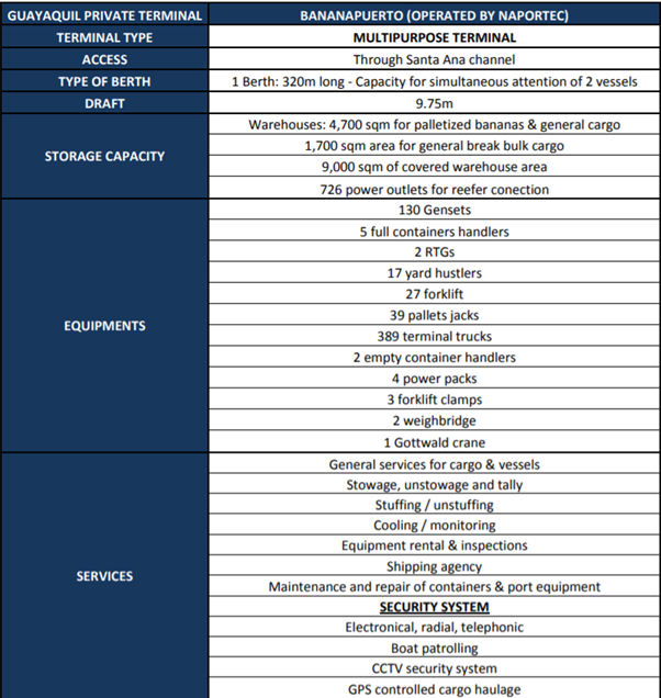
Multipurpose Terminal Bananapuerto
|
Accesss |
Canal Santa Ana |
|---|---|
|
Deep |
9.75 m |
|
Berth |
1 (lenght 320 m) |
|
Warehousing |
4,700 m2 banana palletized & general cargo, 1,700 m2 breakbulk cargo |
|
Type of Cargo |
Banana, Wood, Cold Chain |
|
Services |
Stevedoring Handling, Warehouse and Equipment rental |
|
Certifications |
ISPS Code, ISO 9001, BASC |
Port Handling Equipment
|
Equipment |
Available
|
Total Quantity and Capacity Available |
Comments on Current Condition and Actual Usage |
|---|---|---|---|
|
Dockside Crane |
Yes |
23 Elevators from 50 to 100 tons, for yard operations |
Contecon, in charge of the operation of the terminal, continued with the extension work on the cranes (QC5-QC6). This makes it possible to serve ships with greater draft and greater load. |
|
Container Gantries |
Yes |
6 x Postpanamax ZPMC Ship to Port gantries |
Rail Mounted Gantry (RMG) 2 x 51 tons, |
|
Mobile Cranes |
Yes |
3 |
Equipped with automatic weighing system. |
|
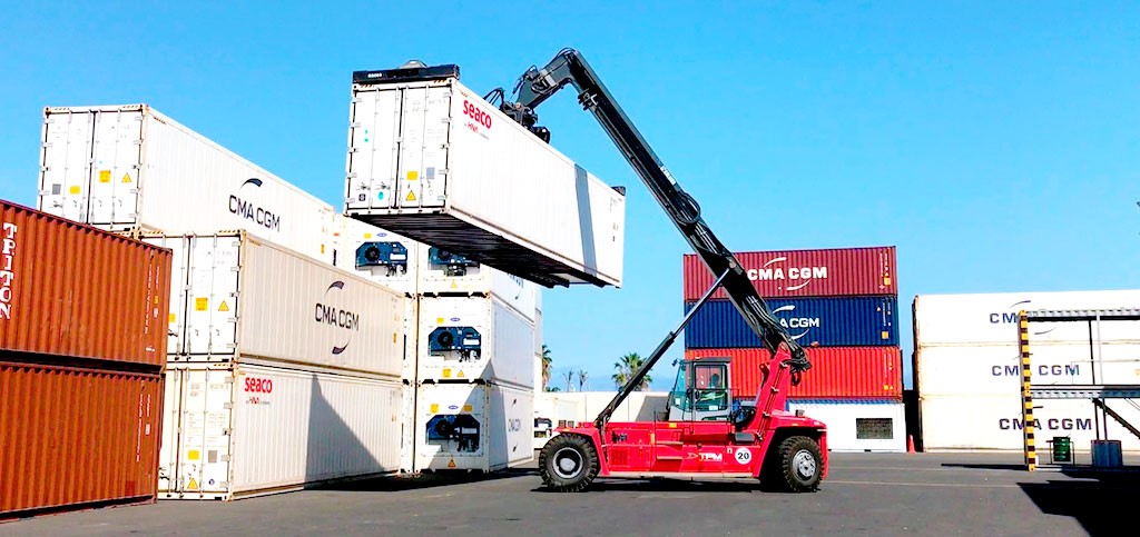
Reachstacker |
Yes |
10 |
Equipped with automatic weighing system. |
|
RoRo Tugmaster (with Trailer) |
Yes / No |
Tracto 25 X 50 Ton
Semi trailer 27 x 40 ton |
The Port Terminal of Guayaquil (TPG), the Chinese electric vehicle manufacturer BYD and the heavy transport company Transcarsell announced the operation of up to 100 100% electric trucks in the port. With the first 20 units, this fleet will operate at the Guayaquil Port Terminal (TPG), on the Trinitarian island. |
|
Grain Elevator with Bagging Machines |
Yes |
2 x 8 MT / hour |
|
|
Transtainer |
N/A |
|
|
|
Forklifts |
Yes |
14 |
From 3 to 25 ton |
Container Facilities
Terminal Contecon
|
TYpe of Cargo |
Yard |
Area (m²) |
|---|---|---|
|
Container |
Nº 1 y 2 |
111365,06 |
|
Container |
Nº 3 |
24099,02 |
|
Container |
Nº 8 |
70790,49 |
|
Bananas |
Nº 9 |
57948,73 |
|
Container |
Nº 300 |
11073,29 |
|
Bananas |
Nº 500 |
6287,39 |
|
Container |
Nº 600 |
10257,06 |
|
Container |
Nº 700 |
20410.80 |
|
Cargo Consolidation & Deconsolidation |
CFS |
28244,78 |
|
Vehicles parking |
Bananero trucks |
30195,99 |
|
Type of Cargo |
Warehouse |
Área (m²) |
|---|---|---|
|
General |
Nº 7 |
7.255,17 |
|
General |
Nº 8 |
7.207,20 |
|
Cold Room (out of order) |
Nº 2 |
4.097,14 |
|
Multipurpose |
Nº 3 |
4.546,64 |
|
Multipurpose |
Nº 4 |
4.546,64 |
|
Multipurpose |
Nº 5 |
4.546,64 |
|
Multipurpose |
Nº 6 |
4.546,64 |
|
Police |
Anti-narcóticos |
1.352,00 |
|
Abandoned Cargo |
Nº 23 |
1.352,00 |
|
Maintenance and Equipment |
Nº 21 y 22 |
2.417,41 |
|
General |
Nº 31 y 32 |
3.853,20 |
|
Banana |
Nº 41 y 42 |
3.911,46 |
|
Banana |
Nº 51 y 52 |
3.903,40 |
|
Banana |
Nº 61-66 |
9.105,69 |
|
Cargo Consolidation & Deconsolidation |
Entre bodega Nº 7 y 8 |
4.218,91 |
|
X Ray screening |
Entre bodega Nº 23 y 24 |
962,00 |
|
HAz-Mats |
Nº 1, 2, 3 |
4.265,44 |
|
Facilities |
20 and 40 ft |
|---|---|
|
Available Container Yard |
See chart |
|
Container Station (CFS) |
See chart |
|
Reefer Container Station |
1,510 positions |
|
Other areas |
N/A |
|
Daily container handling capacity (Cntnrs per hour) |
N/A |
|
Reefer Container Station, connection points |
1,510 plug-in points |
|
Emergency Container Capacity |
N/A |
|
Container Handling x Shift Gang |
N/A |
Customs
For import procedures, the following documentation/information will be required at the service windows of the Billing Department to obtain a gate pass:
The cargo number authorized by SENAE.
For procedures with SENAE authorizations through administrative acts, you must present a copy of the document (Providencia)
Exit Authorization Letter (CAS) (Electronic or Physical)
Copy of the Bill of Lading (BL), for the cases of General Cargo and Loose Cargo
Information of the transport company, or name of the driver and license plate of the vehicle that will collect the load
This documentation will be required by the access control booths before access. The gate pass may also be issued to the customs agent/assistant or other personnel authorized by the importer to carry out customs formalities. The requirements of the “Port Security Manual for the Issuance of Credentials and Provisional Permits” must be met.
For cargo dispatch, warehouses have a scheduled delivery service with assigned shifts, taking into account the following aspects:
Depending on availability, the customer chooses the most convenient shift to pick up their load. Shifts include the earliest and latest pick-up times.
In the event that a client misses their turn (that is, does not arrive at the assigned time), it is possible to request another one the same day at the access control booths.
For cases of Direct Debit (DD) or Advance Clearance (DA), verify that the customs procedure has been authorized and the operation is scheduled in the Customer Service Department.
Customs hours at the port of Guayaquil are from 8:00 am to 12:00 pm and from 1:00 pm to 4:30 pm.
General Cargo Handling Terminals
Terminal Information
The international container terminal consists of three docks of 185 meters each and a storage area of 300,000 m2. The multipurpose terminal includes six 190 berths with 70,000 m2 of storage space, including 4,500 m2 to accommodate dangerous cargo and 3,200 m2 for refrigerated goods.
The Bulk Terminal has a 189 m long dock, three silos and four warehouses to store 3,600 tons. There is also a grain warehouse with a capacity of 30,000 tons and three 9,000 m3 tanks to store heavy liquids such as oil.
Multipurpose terminal
Contecon Muelles Multipropòsito
|
Berth |
Lenght(m) |
Deep (m) |
|---|---|---|
|
Nº 2 |
185 |
10 |
|
Nº 3 |
185 |
10 |
|
Nº 4 |
185 |
10 |
|
Nº 5 |
185 |
10 |
|
Nº 6 |
185 |
10 |
|
Storage Type |
Berth |
|---|---|
|
Bagged Cargo |
Yes |
|
Refrigerated Cargo |
Yes |
|
General Cargo |
Yes |
Main Storage Terminal
At the Contecon Terminal there are well-organized warehouses for both ground operations and classification in tall structures. Products have Contecon barcodes, any item can be identified and located immediately. The surface area of the operational warehouses is 45,800 m2.
Grain Handling Bulk Cargo
Andipuerto Granel ANDIPUERTO is the concessionaire of the multipurpose bulk terminal and the largest dry bulk port facility in Ecuador. The terminal has an area of 13 hectares; it has a dock where ships up to 220 meters in length are received.
Andipuerto Bulk Terminal Tariff Andipuerto Tarifario
|
Berth |
Lenght |
Deep |
|---|---|---|
|
Nº 1D |
155 m |
10 m |
|
Location |
Equipment |
Quantity |
Capacity |
|---|---|---|---|
|
Berth |
Hydraulic Forklift |
7 |
3 x 6m³; 3 x 10 m³, and 1 x 12m³ |
|
Payloaders |
4 |
|
|
|
Hoppers |
5 |
1 x 40m³ and 4 x 20m³ |
|
|
Tansport |
Terminal tractors Ottawa |
8 |
32 Ton. |
|
Hoppers |
5 |
35 Ton |
|
|
Platforms |
6 |
40’ |
|
|
Almacenes |
Grain Elevator |
2 |
8 Tm/h |
|
Forklifts |
14 |
From 3 to 25 Tons. |
|
|
Bulk grain scoop |
4 |
3.5 Ton. |
|
|
Warehouse forklift |
4 |
|
|
|
Front payloader |
5 |
Caterpillar Model 938G II |
|
|
Mini Forklift |
5 |
Cat y Bobcat Model 287B , 242B |
|
|
Tractors |
4 |
Cat Model D5G/LGP |
|
|
Bagging system |
8 |
|
|
Type of Cargo |
Warehouse |
Area (m²) |
|---|---|---|
|
Multipurpose |
Delta |
4.278,00 |
|
Delta 2 |
3.864,00 |
|
|
Delta 3 |
1.122,00 |
|
|
Delta 4 |
918,00 |
|
|
Echo |
5.040,00 |
|
|
Echo 2 |
5.040,00 |
|
|
Fox |
9.072,00 |
|
|
Golf |
9.504,00 |
|
|
Hotel |
9.072,00 |
|
|
Juliet |
8.000,00 |
|
|
Duomo y Anexo |
8.300,00 |
|
Type of Cargo |
Tank |
Quantity |
Capacity |
|---|---|---|---|
|
Liquid Bulk |
Steel |
3,00 |
3200 Ton |
|
|
|
1,00 |
240 Ton |
|
Type of Cargo |
Silos |
Quantity |
Capacidad |
|
Grain Dry |
Acero |
3,00 |
6000 Ton |
|
2,00 |
450 Ton |
||
|
Type of Warehousing |
Number of Facilities |
Area (m2) |
|
|
Bagged Cargo |
4 wrhses 8 bagging machines |
2,160 |
|
|
Cold Cargo |
N/A |
|
|
|
General CArgo |
40 |
103,000 |
|
Stevedoring
The Port of Guayaquil offers the stevedoring and unloading service. The port has adequate equipment and material, duly certified, which guarantees safety and efficiency in cargo handling. Various types of cargo are handled such as containers, agricultural products, general cargo, vehicles, machinery and project cargo. The stevedoring operation is carried out by private companies, classified and regulated by the National Government. The list and ranking of operators is carried out according to the type of activities and services they provide to the terminals (cargo handling, pilotage, towing, dredging, port storage and other activities).
Hinterland Information
By landway
In banana export alone there is a weekly movement of around 1,500 trucks that transport the fruit from Guayas and the Los Ríos Association. The actual cost of the land cost from the Port of Guayaquil to the factories located within the city for 20 and 40 foot dry containers is around USD 180 and USD 250 respectively with a distance of about 15 km. The distances to the main provinces of origin and destination of cargo from the Port of Guayaquil are: Guayas 136km: Guayaquil, Durán, Milagro, La Libertad (136 km.) 11 Manabí 280km: Manta (193km), Jipijapa (254 km. ), Bahía de Caráquez (280km) El Oro 280km: Puerto Bolívar (193km) Pichincha 415 km: Sto. Domingo (287km), Quito (415km) Loja 415km: Loja (415km)
By sea
Ecuador has implemented the maritime security requirements contained in Chapter XI-2 of the International Convention for the Safety of Life at Sea of 1974 and the International Code for the Protection of Ships and Port Facilities (ISPS) through the Merchant Marine Law of 2004 and the Maritime Protection Regulations of 2004. These regulations apply to all seaports in Ecuador and to passenger ships, cargo ships of 500 GRT or more and mobile offshore drilling units on voyages. international.
Port Security
The port of Guayaquil has been the subject of a modernization and improvement program in recent years after a significant financial investment. However, these developments have not resulted in a safer environment for foreign ships, moored along the port's docks or transiting its narrow river passages, which are said to be easy targets for local criminal gangs. While Ecuador has not traditionally been known as a global piracy hotspot, the number and malice of recent attacks on vessels has led the IMB to issue a warning to vessels transiting the river passage in Guayaquil, Ecuador.
The warning comes after a series of incidents in which armed robbers approached and boarded vessels, including those under pilotage. The majority of incidents are reported to have taken place at night between the sea buoy and the entrance and/or exit of the channel. Tactics employed by criminals include shooting at ships to distract crew and allow drugs to be smuggled on board, especially in containers.2
Ecuador has implemented the maritime security requirements contained in Chapter XI-2 of the International Convention for the Safety of Life at Sea of 1974 and the International Code for the Protection of Ships and Port Facilities (ISPS) through the Merchant Marine Law of 2004 and the Maritime Protection Regulations of 2004. These regulations apply to all seaports in Ecuador, as well as passenger ships, cargo ships of 500 GRT or more and mobile offshore drilling units on international trips.
Comprehensive security: The Port of Guayaquil is qualified with the International Code for the Protection of Ships and Port Facilities (ISPS), Zero Theft and the Business Alliance for Secure Commerce (BASC) Certification, in the process of ISO 9,000 and 28,000 certifications.
Security Level
1 applies in territorial waters and maritime ports of Ecuador. Any change in the level of security or its area of application will be communicated through notices to mariners, nautical advisories, circulars, VHF communication or any other appropriate means.
-
Centro de denuncia de piratería de la IMB (IMB PRC) imbkl@icc-ccs.org / piracy@icc-ccs.org. Roberto Barriga Maldonado de Larrea Canessa Barriga Abogados con sede en Guayaquil, Ecuador
|
Security |
|
|---|---|
|
ISPS Compliant |
Yes |
|
Current ISPS Level |
1 |
|
Police Boats |
Yes |
|
Fire Engines |
Yes |
Ecuador - 2.1.3 Port of Manta
Port Overview
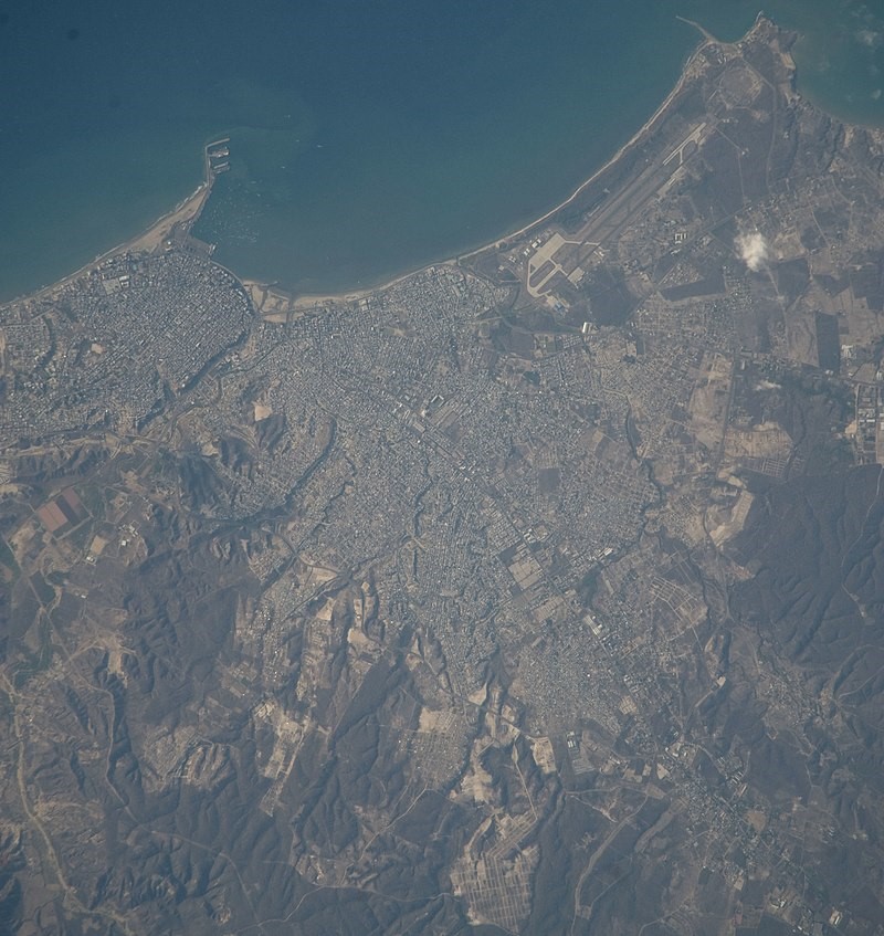
The biggest advantage of the port of Manta is the depth of the water and easy access to berths. The port is designed to handle 2 million tonnes of cargo, 50,000 TEUs and around 60,000 vehicles per year. However, it lacks modern ship-to-shore cargo handling equipment and few covered storage facilities. The geographically central position of Manta is advantageous for the distribution of vehicles both to the north and south of the country, it is also the ideal geographical point to develop a port terminal for post-Panamax ships, because it is in the center of Ecuador, opposite to Asia.
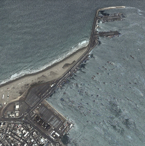
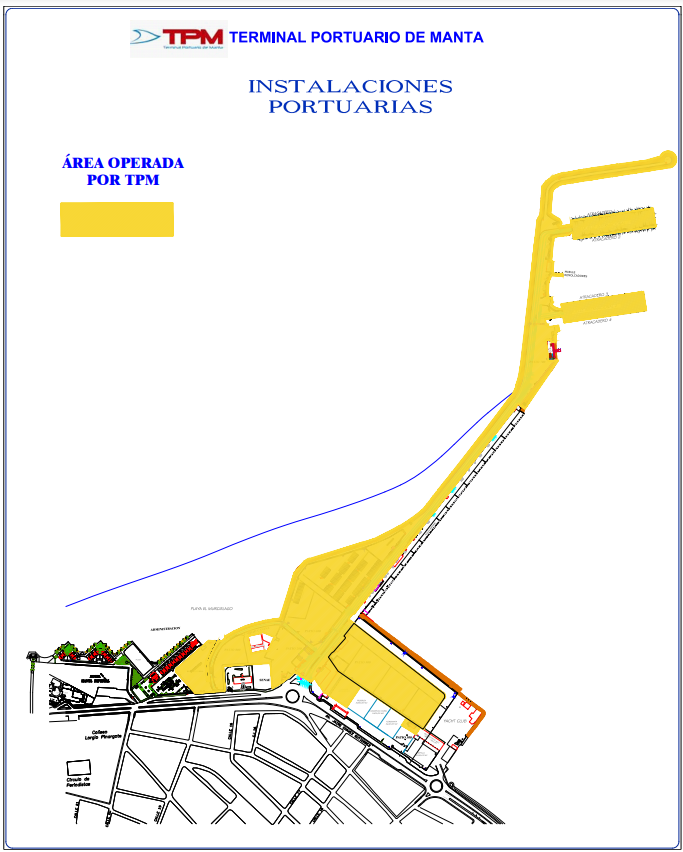
The Port of Manta is divided into two main terminals: 1) International Terminal and 2) Fishing and Cabotage Terminal. It also has two private port terminals and three fishing facilities under the same administration in its jurisdiction. Its dock is 110 hectares protected by a breakwater that allows a quick and practical operation for the arrival, loading and unloading of vessels. Being a Multipurpose Port, the facilities facilitate access for all types of vessels, guaranteeing easy maneuvering of vessels and loading, unloading and supplying operations.
The main export product sent from Manta is fish. Shrimp, tagua, plastic and stationery are also exported. On the other hand, the terminal receives more than 95% of car imports from Ecuador.
Manta-Manaus multimodal axis
In the near future, the Port will have a direct connection to the various projects planned within the Manta-Manaus multimodal axis also known as the Central Logistics Corridor of Ecuador. This is articulated with the Manta airport development project, the Special Development Zone, ZEDE, road initiatives such as the Manta-Quevedo and Manta-Guayaquil highway and the new accesses to the Port.
Source: JSC Gateway to Astronaut Photography of Earth
The main economic activity of Manta consists of the capture and processing of tuna. The intense port movement in the Fishing and Cabotage Terminal, the same one that during 2022 mobilized 72,475.87 metric tons of industrial fishing landed in 268 vessels. In fact, one of the very important factories in the province is Conservas Isabel. The companies that bring together the largest number of Manabi workers are the tuna companies Inepaca, Conservas Isabel, Seafman, Tecopesca and Marbelize. Between 800 and 1,200 workers work there. Manta being the main fishing port of Ecuador, called the “Tuna Capital of the World” due to its high percentage of capture, unloading and processing of tuna from the Fishing and Cabotage Terminal of the port of Manta, has made Ecuador one of the 6 main countries worldwide that capture the tuna resource, according to a report from the Ministry of Foreign Trade, Aquaculture and Fisheries
The Manta Fishing and Cabotage Terminal has an extension of more than 620 linear meters of dock for the service of the artisanal and industrial fishing sector. Very soon this dock capacity will increase with the construction of two jetty-type docks. As it is an open port, it has the protection of a breakwater along its entire length against waves and wind, which guarantees and facilitates maritime-port operations.
Port website: : https://www.puertodemanta.gob.ec/
http://www.camae.org/puerto/autoridad-portuaria-de-manta-apm/
https://www.instagram.com/aportuariamanta/?hl=en
Key port information may also be found at: http://www.maritime-database.com
|
Port Location and Contact |
|
|---|---|
|
Country |
Ecuador |
|
Province or District |
Manabí |
|
Nearest Town or City with Distance from Port |
Manta (4.2 km) |
|
Port's Complete Name |
Port of Manta |
|
Latitude |
-0.959722 |
|
Longitude |
-80.71722 |
|
Managing Company or Port Authority
|
Manta Port Authority |
|
Management Contact Person |
Ronald Lizandro Muñoz (from 27/06/2023) |
|
Nearest Airport and Airlines with Frequent International Arrivals/Departures |
Eloy Alfaro International Airport. It is located on the shores of the Pacific Ocean in the city of Manta. Due to its strategic location, the Eloy Alfaro Air Base and the Manta Naval Air Station operate on the runway of this airport. |
Port Picture
Description and Contacts of Key Companies
http://www.puertodemanta.gob.ec/wp-content/uploads/2017/08/OPERADORES-PORTUARIOS.pdf
For more information on port contacts, please see the following link: 4.4 Port and Waterways Companies Contact List.
Port Performance
The port has a storage area of 150,500 m2 divided into 12 warehouses for storage of containers, vehicles and general cargo. It has capacity for about 5,000 TEU or 4,000 vehicles.
Currently, solid dry bulk cargo and international fishing predominate in the total cargo moved in the Port of Manta with approximately 65% of the total. This category includes exports and imports of tuna, wheat and other frozen cereals. On the other hand, general cargo such as automobiles, machinery and equipment, vehicles, assembly parts, etc., represents 11% of the total; while 24% corresponds to liquid bulks such as vegetable oils and hydrocarbons.
It has two docks, one 200 meters long and the other 300 meters long, with the capacity to receive 4 vessels simultaneously, that is, 800 linear meters of berths for the operation of container ships, bulk carriers, carts, fishing vessels and cruise ships. . . Both docks have a platform width of 45 meters each. It also has another 620 linear meters for exclusively fishing and cabotage activities.
In 2022, 106,515 units of vehicles and machinery were serviced between import, export and transhipment, which represented 53% compared to 2021 (69,571 units); while liquid bulk -vegetable oils- had an increase of 17%.
In the Port of Manta, three projects will be executed for a total of USD 10 million, which include the expansion of International Pier number 2 by an additional 60 meters, the construction of multipurpose warehouses and the enlargement of the monitoring center (CCTV).
|
Seasonal Constraints |
||
|---|---|---|
|
|
Occurs |
Time Frame |
|
Rainy Season |
Yes |
From December to March. It rains between 150 to 250 mm³ annually |
|
Major Import Campaigns |
No |
|
|
Other Comments |
This area, due to the direct influence of the Cold Humboldt Current most of the year, is very dry and rainfall is extremely scarce. Unlike the rest of the Ecuadorian coast, whose climate is extremely hot, rainy and humid par excellence, the climate of Manta is very different, due to its geographical location in the Center – South of Ecuador. |
|
|
Handling Figures for 2022 |
|
|---|---|
|
Vessel Calls |
700 international and ECU ships,
(2021, 515 Intl and Ecu ships; 2020 186 ships) |
|
Container Traffic (TEUs) |
6500 containers in 2022.
(2021 8,019 TEU's, 3,548 TEU's impo and 4,471 TEU's expo with average of 169 TEU's per vessel)
|
|
Handling Figures Bulk and Break Bulk for 2022 |
|
|---|---|
|
Bulk (MT) |
Total Bulk and Loose Cargo 1,096,317 MT 2022
(1,168,534 MT served in 2021; 1,013,000 MT in 2020)
(463,333 MT in 1st half of 2023) |
|
Break bulk (MT) |
See previous figure |
Additional note: The Fishing and Cabotage Terminal mobilized 72,475.87 metric tons of industrial fishing landed in 268 vessels in 2022
Discharge Rates and Terminal Handling Charges
For detailed information on rates visit: https://www.tpm.ec/servicios-generales/
Berthing Specifications
Container, bulk and Ro-Ro operations can be carried out at berths with a 12m draft, allowing vessels with a draft of 11m. For RoRo vessels that only have a stern ramp, there are two dock ramps, at the end of each side of the first (inner) dock. Boats can approach to starboard or port, but the tidal range of approximately 3 meters should be considered when working on a fixed concrete ramp.
|
Type of Berth |
Quantity |
Length (m) |
Maximum Draft (m) |
Comments |
|---|---|---|---|---|
|
Conventional Berth |
2 |
200m x 45m w) |
|
Two 200-meter-long jetty-type docks with the capacity to receive 4 vessels simultaneously, that is, 800 linear meters of berths for the operations of container ships, bulk carriers, tankers, fishing vessels and cruise ships.
Both docks have a platform width of 45 meters each. |
|
Container Berth |
Yes |
185m |
10m |
|
|
Silo Berth |
Yes |
N/A |
15m |
|
|
Berthing Tugs |
Yes |
1 |
|
|
|
Water Barges |
N/A |
|
|
Water supplier https://www.searates.com/port/manta_ec |
TPM has 2 jetty docks, one of 200 meters and the other that was extended by 100 meters, leaving 300 meters in length, which in turn offer 4 berths totaling 1000 linear meters capable of receiving four large vessels at the same time (commercial, tourism, fishing, etc.) simultaneously, that is, intended for the operations of container ships, bulk carriers, tankers, fishing vessels and cruise ships. Both docks have a platform width of 45 meters each and an average depth of 12.5 meters (MLWS).
DOCK 1:
Length: 200 meters. Width: 45 meters. Area: 9000 square meters
Berth 1: Depth: 11 meters Cargo: All types of ship
Berth 2: Depth: 12.5 meters Cargo: All types of ship
DOCK 2:
Length: 300 meters. Width: 45 meters Area: 9000 square meters
Berth 1: Depth: 12.5 meters. Cargo: All types of ship
Berth 2: Depth: 12.5 meters Cargo: All types of ship
SUPPLIES
Provisions: Yes
Bunker: Yes.
Water: Yes
Lubricants: Yes
Engines, parts: Yes
https://www.searates.com/port/manta_ec
General Cargo Handling Berths
Services
A) Solid Bulks (Wheat, corn, soybean paste, urea, klinker, Pet coke) National and International Fisheries
Unloading cereal to truck • Direct unloading of frozen fish • Port area operation by crane • Use of Infrastructure for dry bulk • Use of Infrastructure for fishing
B) Liquid Bulks (Fatty oils, sunflower, olive, caustic soda, biodiesel)
• Loading/Unloading of liquid bulk from/to truck • Port area operation by crane • Use of Infrastructure for liquid bulk
C) Refrigerated and Dry Containers
• Loading and unloading of full container • Loading and unloading of empty container • Loading of full container transshipment • Container re-stacking • Crane movement (hold lids and removals) • Power connection of refrigerated containers for export • Power connection of containers refrigerated import • Container storage • Positioning and transfer for container inspection • Return inspection to container yard • Reception and delivery of full containers • Late arrival of containers • Transportation of full containers • Reception and delivery of empty containers • Shipping services support for the physical inspection of containerized merchandise • Consolidation and deconsolidation • Import weighing • Import seals
D) Vehicles, Machinery
Loading and Unloading of vehicles of equal or less than 3 tons • Loading and Unloading of vehicles of more than 3 tons • Reloading of vehicles less than 3 tons to the dock • Reloading of vehicles less than 3 tons on board • Movement of vehicles greater than or equal to to 3 tons • Movement of vehicles less than 3 tons • Tray • Fuel tanking • Vehicle storage • Reception and delivery of vehicles
E) General Cargo
Loading and unloading of general merchandise • Storage of general merchandise • Positioning for inspection of general merchandise • Return of inspection of general merchandise • Reception and delivery of general merchandise • Support services for the physical inspection of loose general merchandise
|
Cargo Type |
Berth Identification |
|---|---|
|
Imports - Bagged Cargo |
N/A |
|
Exports - Bagged Cargo |
N/A |
|
Imports and Exports - RoRo |
N/A |
|
Other Imports |
In Imports, Ro-Ro Cargo Vessels arrive at the Port, General Cargo such as Iron, steel and other metals, various machines and equipment and parts for vehicle assembly, as well as containerized cargo with Tuna, Chemical Compounds and Various Preserved Foods. |
Port Handling Equipment
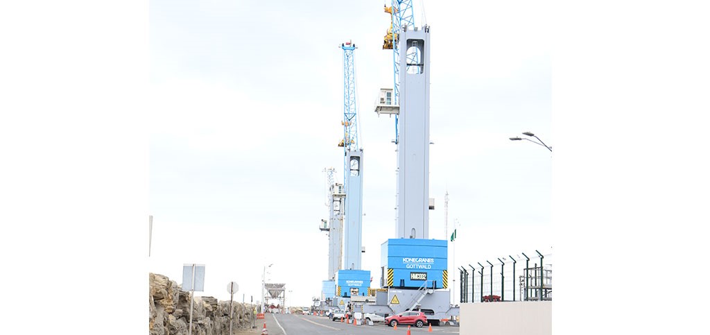
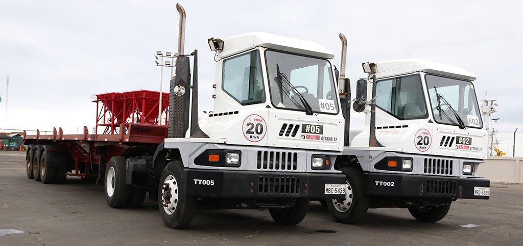
TPM currently has the following port equipment:
• 5 Tract trucks
• 5 Platforms
• 1 3 ton forklift
• 2 Reach Stackers Container Ships (Full Containers)
• 1 Reach Stacker Container Machine (Empty Containers)
• 4 Scales
• 60 Reefer Shots
• 2 Mobile Port Crane (G HMK)
• 4 Hoppers capacity 50 cubic meters
• 4 SMAG Lifting Technologies Peiner Spoons capacity 12 cubic meters
|
Equipment |
Available
|
Total Quantity and Capacity Available |
Comments on Current Condition and Actual Usage |
|---|---|---|---|
|
Dockside Crane |
Yes |
Gottwald Kone Crane HMK 41mt |
|
|
Container Gantries |
No |
|
|
|
Mobile Cranes |
Yes |
Gottwald Kone Crane HMK 41mt |
|
|
Reachstacker |
Yes |
Reach stackers 40 tons, 2 x Kalmar (45 mt) Full cntnr. 1 x Kalmar 9 (mt) Empty cntnrs only |
|
|
RoRo Tugmaster (with Trailer) |
Yes |
5 “Ottawa” tracto/trailers |
|
|
Grain Elevator with Bagging Machines |
No* |
|
4 Hoppers 50m3
4 Peiner scoop* SMAG Lifting Technologies cap12m3
|
|
Transtainer |
No |
|
|
|
Forklifts |
Yes |
Forklift 3 TM, Forklift 7 TM |
|
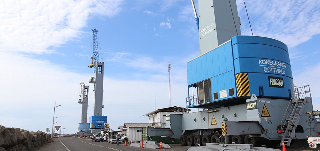
(*)Institutional Video unloading bulk cargo at Port of Manta: https://youtu.be/btutNgnecPE
Container Facilities
The Gottwald mobile crane can support the entire unloading process, but to be able to work with more than one group it is necessary to use ship rigging (Self Sustained Cranes). A port user reported that the mobile crane is often out of service. Once unloaded, the containers must be transported by truck for approximately 1.5 km to the storage yard.
|
Facilities |
20 ft & 40 ft |
|---|---|
|
Container Facilities Available |
Yes |
|
Container Freight Station (CFS) |
Yes |
|
Refrigerated Container Stations |
60 Reefer outlets |
|
Other Capacity Details |
4 scales |
|
Daily Take Off Capacity |
N/A |
|
Number of Reefer Stations |
60 outlets |
|
Emergency Take-off Capacity |
N/A |
|
Off take Capacity of Gang Shift |
N/A |
Customs Guidance
For import procedures, the following documentation/information will be required at the service windows of the Billing Department to obtain a gate pass:
The cargo number authorized by SENAE.
For procedures with SENAE authorizations through administrative acts, you must present a copy of the document (Providencia)
Exit Authorization Letter (CAS) (Electronic or Physical)
Copy of the Bill of Lading (BL), for the cases of General Cargo and Loose Cargo
Data from the transport company, or name of the driver and license plate of the vehicle that will pick up the load.
This documentation will be required by the access control booths before access. The gate pass may also be issued to the customs agent/assistant or other personnel authorized by the importer to carry out customs formalities. The requirements of the “Port Security Manual for the Issuance of Credentials and Provisional Permits” must be met.
For cargo dispatch, warehouses have a scheduled delivery service with assigned shifts, taking into account the following aspects:
Depending on availability, the customer chooses the most convenient shift to pick up their load. Shifts include the earliest and latest pick-up times.
In the event that a client misses their turn (that is, does not arrive at the assigned time), it is possible to request another one the same day at the access control booths.
For cases of Direct Debit (DD) or Advance Clearance (DA), verify that the customs procedure has been authorized and the operation is scheduled in the Customer Service Department.
Terminal Information
Malecón Avenue, Jaime Chávez Gutiérrez S/N and 20th Street (next to the entrance to the port) Blanket
(+593) 5 370 2490 ext. 5100
The Terminal has a registry of registered Land Transport Operators. For more information see: https://www.tpm.ec/operadores-de-transporte-terrestre/ y https://tpm.ec/wp-content/uploads/2022/07/Copia-de-BASE-OTT18072022.pdf
MULTIPURPOSE TERMINAL
Photo: Courtesy TPM
The Port of Manta is considered multipurpose; In other words, it can serve various market segments; Today, its international terminal, delegated to the company Manta Port Terminal (TPM), moves solid bulk cargo (wheat, urea and fish), liquid bulk (vegetable oils) and general cargo (machinery and vehicles); Meanwhile, the Port Authority of Manta, in charge of the administration of the Fishing and Cabotage Terminal, serves the industrial and artisanal fishing fleet; In addition, it has been making important investments in infrastructure to rebuild said terminal and recover port and fishing activity in the city of Manta, an objective that has been achieved with the help of the Ministry of Transportation and Public Works, with whom efforts are intensified to have with new pier-type docks that will double the capacity to serve the fishing fleet in terms of linear meters for docking vessels at 10, 9 and 7 meters draft; enabling more than 620 linear meters of access roads to the fishing terminal to facilitate port operations.
GRAIN AND BULK HANDLING
For the unloading manoeuvre it is necessary to use the ship's rigging (self-unloading peiner scoop). Best case: practical size bulk carrier of approximately 40,000 TDW, 4 to 5 hatches. The port has sufficient hoppers into which the cargo is unloaded; trucks pass underneath to take the cargo to a warehouse outside the dock.
Institutional Video unloading bulk cargo at the Port of Manta: https://youtu.be/btutNgnecPE
MAIN STORAGE TERMINAL
For the storage of containers, vehicles and general cargo, there is a total area of 110,500m2, divided into 7 different patios. Depending on the type of cargo, it has capacity for 5,010 TEU or 4,240 vehicles (passenger cars).
TPM has two yards for storage of different types of cargo such as vehicles, containers, general cargo, dangerous cargo, and bulk cargo.
-
PATIO 600: 32,768.57 m2
-
PATIO 500: 30,731.34 m2
-
PATIO 200: 8,020.55 m2
-
PATIO 800: 11,706.26 m2
|
Storage Type |
Number of Storage Facilities |
Area (m2) |
|---|---|---|
|
Bagged Cargo |
7 |
110,500m2 TOTAL |
|
Refrigerated Cargo |
N/A |
- |
|
General Cargo |
5 |
- |
Stevedoring
Cargo Operators are registered companies that provide services in the Port of Manta, whose services allow the management and execution of specialized technical activities for the transfer of loading and unloading carried out on ships/vessels; loading, unloading, storage, warehousing, mobilization services in the port area, stowage, re-stowage and unloading, etc. Port cargo operators have specialized machines, equipment, tools and safety implements for their properly trained and specialized workers.
Hinterland Information
Malecón Avenue, Jaime Chávez Gutiérrez S/N and 20th Street (next to the entrance to the port) Blanket
(+593) 5 370 2490 ext. 5100
The Terminal has a registry of registered Land Transport Operators. For more information consult:
https://www.tpm.ec/operadores-de-transporte-terrestre/ and
https://tpm.ec/wp-content/uploads/2022/07/Copia-de-BASE-OTT18072022.pdf
ACCESS TO THE PORT AREA
Access to the port facilities is through Jaime Chávez Gutiérrez Avenue (Malecón) and 4 de Noviembre Avenue, which is 4 km long and connects the port with the routes to Quito and Guayaquil. The lateral passage, 18 km long, interconnects the port with the Manta - Rocafuerte - Quito road; Manta - Montecristi - Jipijapa - Nobol - Guayaquil, built to decongest vehicular traffic. The 8.5 km long Puerto - Airport road forms the peripheral ring with the lateral passage and connects with the Manta-Montecristi-Guayaquil highway. The Coastal Route connects the port of Manta with all the tourist sites in Ecuador. The Avenue of Culture is quickly interconnected with the lateral passage allowing quick mobilization towards the road to Portoviejo.
ACCESS TO THE SERVICE AREA
Dock access rules
Access to the docks and traffic areas of the ports, to people and vehicles that, due to their functions or services therein, are duly authorized. It is the responsibility of the maritime authority and/or whoever has jurisdiction to grant these authorizations to passengers and other people boarding the ships, as well as to the crew of the ships in port. It is the responsibility of the APM to grant access authorizations to all types of vehicles and people involved in the execution and conservation of works and facilities, in loading, unloading operations, circulation in the docks and everything related to the use of the different works intended for them. to port operations. Non-public servants who depend on the authorities who, due to their function, must enter the port, will be provided with sufficient documentation, and must show said documentation to the guards and security when required to do so.
Industrial vehicles and machinery.
The access of industrial vehicles and mobile machinery will be authorized in each case by the Comprehensive Security Directorate of the APM, which may control the characteristics and state of conservation and operation, in accordance with the provisions of the ISPS Code and/or BASC, without any liability arising for the APM or its staff, in the event of an accident.
MOVING AROUND THE SERVICE AREA
Vehicles
Vehicles of all types that circulate through the port must do so with due precautions and respecting existing traffic signs. When crossing the tracks or stopping on them to take or leave cargo, in cases where this is not expressly prohibited, they will do so with the driver being willing to remove it from the road as soon as necessary. The unit loads per axle, as well as the tire inflation pressure, will not be higher than those established by national road standards or specific standards issued by the Ministry of Transportation and Public Works, MTOP. The exhaust pipes of internal combustion engines will be closed or explosion-protected type. The circulation of light vehicles (cars, motorcycles, etc.) is prohibited due to the loading and unloading area, understood as that located under the radius of action of cranes and other facilities for handling goods. Vehicles will not be allowed to travel through the general circulation areas of the docks and service roads at speeds greater than 60 kilometers per hour, nor through other places other than the roads intended for their transit.
Port Security
Ecuador has implemented the maritime security requirements contained in Chapter XI-2 of the International Convention for the Safety of Life at Sea of 1974 and the International Code for the Protection of Ships and Port Facilities (ISPS) through the Merchant Marine Law of 2004 and the Maritime Protection Regulations of 2004. These regulations apply to all seaports in Ecuador, as well as passenger ships, cargo ships of 500 GRT or more and mobile offshore drilling units on international trips.
Security Level 1 applies in territorial waters and maritime ports of Ecuador. Any change in the level of security or its area of application will be communicated through notices to mariners, nautical advisories, circulars, VHF communication or any other appropriate means.
|
Security |
|
|---|---|
|
ISPS Compliant |
Yes |
|
Current ISPS Level |
1 |
|
Police Boats |
Yes |
|
Fire Engines |
Yes |
Ecuador - 2.1.4 Port of POSORJA (Guayaquil Area)
Port Overview
The Posorja Smart Deep Water Port has a privileged geographical location on the west coast of the South Pacific and its expeditious maritime access channel with a depth of 16 meters, which allows the entry of Neo Panamax vessels with a capacity of up to 15,000 TEU, the largest in the shipping industry.
The Container Port Performance Index (CPPI) places the Smart Deep Sea
Water Puerto de Posorja in the Top 10 efficient ports in South America, Central America and the Caribbean.
Through this Port, Ecuador connects directly with the main markets of
Northern Europe, Asia, Mediterranean, Caribbean, Central America and the west coast of South America.
Courtesy https://www.dpworld.com/es/ecuador
Port website: https://www.dpworld.com/es/ecuador
Key port information may also be found at: http://www.maritime-database.com
|
Port Location and Contact |
|
|---|---|
|
Country |
Ecuador |
|
Province or District |
Guayas |
|
Nearest Town or City with Distance from Port |
Guayaquil, 85km |
|
Port's Complete Name |
Posorja Deep Waters Port |
|
Latitude |
-2.7081505, |
|
Longitude |
-80.24097 |
|
Managing Company or Port Authority |
DP World Posorja https://www.dpworld.com/es/ecuador |
|
Management Contact Person |
Carlos Merino, CEO de DP World Ecuador Port Operator, FCL +593 4 380 4850 dpworldposorja.com.ec |
|
Nearest Airport and Airlines with Frequent International Arrivals/Departures |
José Joaquín de Olmedo International Airport
American Airlines, Avianca, Copa Airlines, Iberia, KLM, LAN, Air Europa, Latam, TACA, TAME, UPS |
Port Picture
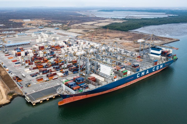
Description and Contacts of Key Companies
|
Compañia |
Servicios |
Contacto |
Correo electrónico/ Website |
|---|---|---|---|
|
Andipuerto Guayaquil S.A. |
Multipurpose grain terminal, bulk |
||
|
Aretina |
Port Logistics Operator FCL, bulk, warehouse, container yard |
||
|
Contecon Guayaquil S.A. |
Port Terminal Operator |
+593 4 600 6300 |
|
|
DPWorld Posorja |
Port Operator, FCL |
+593 4 380 4850 |
|
|
Ecuaestibas S.A. |
Tugs, berthing |
+593 042 517 360 |
|
|
M&C Surveyors |
Consultancy and surveying services to the marine, commodities and insurance sectors |
+51947245898 |
|
|
Petrocomercial |
Fuel, bunkering, greases, oil products |
043803000 |
|
|
Puerto Trinitaria - Trinipuerto S. A |
Support Activities for Rail Transportation |
+593 4 269 7244 |
|
|
QC Terminales Ecuador |
Port Terminal, Bulk oil, chemical, warehouse |
||
|
Setmabas S.A. |
Ship services, technical support and supplies |
+593 4-202-8158 |
|
|
Terminal Portuario de Guayaquil TPG |
Port Terminal, FCL |
Port Performance
2019 Start of operations
- The aspiration of DP World Posorja in its first year of operation is to move 250,000 to 300,000 teus. Due to its draft level, its projection is to receive neo-post-Panamax vessels, 330 meters in length and which usually carry around 10,000 teus.
- Has handled thousands of containers and more than 40 Post-Panamax vessels. Posorja is expected to receive an annual volume of 750,000 TEUs during the first phase, and 1.5 million TEUs at full port capacity.
2021
- The new record was achieved after the docking of the container ship “Jean Gabriel”, of the CMA CGM shipping company, a 299-meter-long ship, which after an efficient operation, set sail on March 31, 2021 with a draft of 14. 48 meters, this being the vessel with the greatest depth that has left Ecuador.
- DP World Posorja confirms its leadership in offering cutting-edge technology with the international recognition granted by Furukawa Electric and which places it as one of the ports with the greatest technology on the west coast of South America.
2022
- DP World Posorja (Guayaquil) once again stands out for its operational efficiency, productivity and service, ranking No. 19 globally and 2nd. in the region of Central and South America and the Caribbean, according to the world ranking Container Port Performance Index 2022 CPPI By Region 2022 (CPPI), prepared and published by the World Bank and S&P Global Market.
- In less than three years of operations, DP World Posorja is already located in the top 10 of efficient ports in South America, Central and the Caribbean
- Capture of 30% of the banana export market, which goes to northern Europe.
- DP World Posorja, responsible for the Posorja Deepwater Port, set records in productivity figures at the regional level, reaching movements of up to 47.1 containers per hour. This translates into each crane loading or unloading 47.1 containers every hour.
- The deep-water Guayaquil port in Posorja marks a new milestone: having reached 1 million TEUs mobilized since the beginning of its operations in August 2019, under a high level of port security and efficiency.
Seasonal Constraints
|
Occurs |
Time Frame |
|
|---|---|---|
|
Rainy Season |
Yes |
From December to March |
|
Major Import Campaigns |
No |
|
|
Other Comments |
||
|
Handling Figures for 2022 |
|
|---|---|
|
Vessel Calls |
Data not available https://www.dpworld.com/en/ecuador/our-services/ports-and-terminals/dp-world-posorja |
|
Container Traffic (TEUs) |
55,000 TEU’s ( installed capacity x year) |
|
Handling Figures Bulk and Break Bulk for 2022 |
|
|---|---|
|
Bulk (MT) |
N/A |
|
Break bulk (MT) |
N/A |
Discharge Rates and Terminal Handling Charges
/cloudfront-us-east-1.images.arcpublishing.com/eluniverso/TRGXGNL3NFC5TIN353TDSFZF2Y.jpg)
Photo: Courtesy DP World Posorja
For information on rates please see: https://www.dpworld.com/en/ecuador/information/rates
Berthing Specifications
|
Type of Berth |
Quantity |
Length (m) |
Maximum Draft (m) |
Comments |
|---|---|---|---|---|
|
Conventional Berth |
Mo |
|
||
|
Container Berth |
Yes |
400m |
15m |
|
|
Silo Berth |
No |
|
||
|
Berthing Tugs |
N/A |
|
||
|
Water Barges |
No |
|
For more information see: https://www.dpworld.com/en/ecuador/our-services/ports-and-terminals/dp-world-posorja
General Cargo Handling Berths
|
Cargo Type |
Berth Identification |
|---|---|
|
Imports - Bagged Cargo |
No |
|
Exports - Bagged Cargo |
No |
|
Imports and Exports - RoRo |
N/A |
|
Other Imports |
Container berth |
Port Handling Equipment
|
Equipment |
Available |
Total Quantity and Capacity Available |
Comments on Current Condition and Actual Usage |
|---|---|---|---|
|
Dockside Crane |
Yes |
4 |
Quay crane Nave-Puerto |
|
Container Gantries |
Yes |
5 |
El puerto está equipado con una infraestructura de clase mundial y cuenta con las grúas pórtico más grandes de Sudamérica. |
|
Mobile Cranes |
Yes |
15 |
Rubber-tire-gantry cranes (RTG). |
|
Reachstacker |
Yes |
||
|
RoRo Tugmaster (with Trailer) |
Yes |
||
|
Grain Elevator with Bagging Machines |
No |
||
|
Transtainer |
Yes |
5 |
|
|
Forklifts |
Yes |
Container Facilities
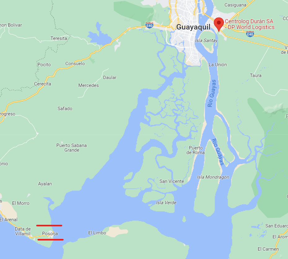
In 2021, the DP World Logistics Center in Durán completed one year of operation. These facilities are located in a strategic industrial area and have a portfolio of integrated logistics services such as: empty container warehouse, container yard and cargo warehouses.
|
Facilities |
20 ft |
40 ft |
|---|---|---|
|
Container Facilities Available |
17.3 hectares total 20'+40' Annual Installed Capacity of 55,000 TEUs |
|
|
Container Freight Station (CFS) |
40 |
|
|
Refrigerated Container Stations |
2,184 constant temperature monitoring electrical outlets |
|
|
Other Capacity Details |
||
|
Daily Take Off Capacity |
In 2022 record, 47 containers / hour |
|
|
Number of Reefer Stations |
2,184 constant temperature monitoring electrical outlets |
|
|
Emergency Take-off Capacity |
In 2022 record, 47 containers / hour |
|
|
Off take Capacity of Gang Shift |

Cortesía https://www.dpworld.com/es/ecuador
Customs Guidance
IMPORTATION PROCESS
The first step is for all actors to register (transport company/exporter and customs agent if applicable. The instructions for company registration are detailed below: https://www.dpworldposorja.com.ec/download /registro-de-usuarios/ and the link to find the requirements https://www.dpworldposorja.com.ec/requisitos-dponline/.
Note the requirements that you must upload on the DPOnline platform during your registration:
• Updated RUC
• Appointment of the Legal Representative
• ID or Passport of the Legal Representative
• Declaration of Security and Anti-drug Conduct signed by the Legal Representative
• Return for the last month of electricity, water or telephone services
• Sketch of the company address
• Screen print of the registration in Ecuapass: “Customer Support” option
• Modify user registration information.
• Modify foreign trade representative registration information.
• It must include: -Company information – Operation information.
The Anti-drug Safety and Conduct Declaration can be found at this link
After you have the username and password, you must continue with the following steps.
The second step must associate the transport companies with which you work with your profile, instructive detail for that purpose: https://www.dpworldposorja.com.ec/download/sociacion-companies-creacion-usuarios-dependientes/
The third step for the import, you must first invoice the services, consider the following instructions, where you can find the steps to invoice and our collection channel: https://www.dpworldposorja.com.ec/download/facturacion-pagos-estados-cuenta /
The fourth step is to make the import departure appointment. It must be generated when you have an authorized departure by SENAE, CAS of the authorized shipping company and the payment for our services. In this link you will find the instructions that you must follow https://www.dpworldposorja . com.ec/download/creacion-manejo-citations-conteneres/
In addition to the above detailed, I would like to detail the Notices of our company related to export cargo:
Notice of Export Payment Collection Channel https://www. dpworldposorja.com.ec/download/25-noviembre-2021-canales-recaudacion/
Notice of Agility to enter the Port in inspections and/or capacity https://www. dpworldposorja.com.ec/download/12-de-mayo-2022-important-information-entrance-to-the-port-facility-inspections-capacity/
If you have any questions or queries, please contact us in order to provide you with the respective support as soon as possible.
We put at your disposal the Automatic Notification Service, with which you can receive information on the traceability of your container from its entry or unloading to its departure or boarding.
https://www.dpworldposorja.com.ec/download/dponline-servicio-notificaciones- automaticas/
Concerns will be received through the following channels:
Email:servicioalcliente.posorja@dpworld.com Telephone: + 593 4 3806100 – Option 1
Note: For requests after 5:00 p.m., weekends and holidays, please contact + 593 98 075 0099
Terminal Information
MULTIPURPOSE TERMINAL
No
GRAIN AND BULK HANDLING
No
MAIN STORAGE TERMINAL
El centro logístico Duran cuenta con un espacio de 17.3 hectáreas, moderno, amplio y seguro dividido en dos grandes áreas: la primera para consolidación de carga de banano y carga seca como cacao y café; y la segunda, para el depósito de contenedores vacíos.
El espacio destinado para la consolidación de banano tiene 8 bahías de carga y descarga a nivel de la plataforma
En la segunda área, destinada para depósito de contenedores vacíos, se brindará el servicio de lavado, taller y mantenimiento. A esto se suma otros servicios como estiba y paletizado; zona de contenedores refrigerados y realización de PTI.
El centro logístico cuenta con una plaza de transporte, con capacidad de 40 camiones y oficinas administrativas. Adicionalmente, se está trabajando en un convenio con la Policía Nacional Antinarcóticos quienes realizarán inspecciones en el Centro Logístico.
Contenedores
El depósito se encuentra en el interior del puerto en Posorja y es complementario al ya inaugurado depósito de contenedores, que funciona en el moderno Centro logístico en Durán. Cuenta con 2.184 tomas eléctricas de monitoreo constante de temperatura de contenedores de la terminal y tiene una capacidad anual de 55.000 TEUS.
Stevedoring
Information not available
Hinterland Information
The project results in being the first Smart Deepwater port terminal in Ecuador with a capacity to receive Neo Panamax vessels of up to 15,000 TEUS, a new 21 km road to give direct, orderly and safe access to the port, a new and more secure access channel 16.5 meters deep and 21 nautical miles long, and finally, a Logistics and Industrial Park next to the port in Posorja with ZEDE (Special Economic Development Zone) modality.
Port Security
The port in Posorja now has the highest technology in fiber optic communications infrastructure to optimize its administrative and logistical processes, and thus provide 100% optimal connections to all its staff. It has cranes that communicate with each other and with all the dock systems, the container yard, the communication boxes and with the two computer centers that are located in the administrative building and in the workshop, which allows communications. redundant online. Likewise, equipment with the Navis TOS operating system is installed on the gantry cranes, which is connected to other computer systems in the port; security camera systems are also included.
SAFETY RULES FOR CARRIERS
DO NOT take photographs or make videos inside the port facility.
DO NOT bring any type of weapons or explosive devices of any type.
DO NOT enter artifacts that may cause harm to third parties.
NOT receive or give money to DP World staff or contractor in exchange for a service.
Use PPE – Personal Protective Equipment.
Check that the vehicle does not have leaks or mechanical problems.
Respect and comply with traffic laws.
Rest enough before starting a journey driving a vehicle.
SAFETY RULES FOR TRAFFIC IN GENERAL
The maximum speed allowed INSIDE THE TERMINAL in a straight line is 30km/h and in curves is 15Km/h.
The maximum speed on the ROAD for heavy vehicles is 70 km/h in a straight line and for access curves to roundabouts or others it must be less than 30 km/h to avoid overturning. IMPORTANT: The authority has installed radars along the road.
The driver is NOT allowed to talk or chat on the phone while driving.
It is MANDATORY to use the seat belt at all times.
Driving against traffic is PROHIBITED.
For more information on security contact: controldeaccesos.psj@dpworld.com
Telephone: + 593 4 3804850 / + 593 4 3806100 – Ext: 2071, 2072, 2073
|
Security |
|
|---|---|
|
ISPS Compliant |
Yes |
|
Current ISPS Level |
1 |
|
Police Boats |
Yes |
|
Fire Engines |
Yes |
Ecuador - 2.2 Aviation

In Ecuador there are twenty-one (21) airports. Four international certified airports (Quito, Guayaquil, Manta and Latacunga). Only 2 are receiving a significant number of international flights (more than 10 airlines): 1) “Mariscal Sucre” (SEQM) in Quito, operated by Corporación Quiport S.A. and 2) “José Joaquín de Olmedo” (SEGU) in Guayaquil operated by Terminal Aeroportuaria de Guayaquil S.A.
Note: The Manta Airport is in transition of management from the DGAC to the Decentralized Autonomous Government GAD Manta or some other operating institution while the Latacunga Airport is operated by the DGAC
Currently, Cuenca Airport “Mariscal La Mar” (SECU) is in the adaptation process, which dates back to several years of efforts and significant technical investments, to obtain certification as an international airport. However, statements and inscriptions of the International Airport or “Internationalization of the Airport” are constantly verified. The technical evaluation is scheduled for the end of 2023.
Cargo flight movements in Ecuador are operated through both regular and ad-hoc flights. The number of cargo flights entering Ecuador is increasing at a rate of 1% annually while the number of cargo flights leaving the country is increasing at a rate of 3% annually.
Challenges and Progress
Ecuador has positioned itself as an important air market after the 2020 pandemic. Currently, the country has recovered its connectivity strongly: close to 10% above the levels of March 2019 for domestic traffic and 83% of the same period for international traffic.1
Peter Cerdá, Regional Vice President for the Americas of IATA2, highlighted three fronts that must be addressed by the authorities, in order to enhance air connectivity for passengers and cargo, which in turn boost tourism, trade, logistics and foreign investment in the country*:
1) Dialogue with municipal authorities to explore growth opportunities and with air operators to evaluate an airport cost structure,
2) Review overflight and traffic control service rates since they are currently some of the highest in Latin America and this can negatively influence market competitiveness.
3) Grow the domestic and international connectivity of other cities in Ecuador and thus provide many more opportunities to the country.
(*) Ecuador Aviation Day, extract, Opening speech – Peter Cerdá June 21, 2023
Note: References verbatim
Supervising Authority

General Directorate of Civil Aviation (Directorate General of Civil Aviation) is the civil aviation authority of Ecuador located in Quito. It oversees the regulation and safety of civil aviation, including airplanes, airports and pilots. This directorate as a government entity is in charge of the management and development of the country's civil aviation industry. Ecuador DGAC implements technical directives as well as quality assurance protocols in compliance with national and international standards.
The Civil Aviation Authority of Ecuador also investigates aviation accidents and incidents and has the following functions:
Provide safe and efficient air navigation services to all aircraft flying within the airspace of Ecuador.
Develop and maintain operational safety oversight capacity, in accordance with the standards established by the International Civil Aviation Organization (ICAO); and work with/advise the Government of Ecuador on technical issues affecting the aviation industry.
Implement government policies on civil aviation and coordinate and advise stakeholders on general development issues affecting civil aviation.
Civil Aviation Law of Ecuador Aviación Civil
Civil Aeronautical Code of Ecuador Código-Aeronáutico
ICAO Convention on International Civil Aviation - Doc 7300
Ecuador acceded to the ICAO Convention on International Civil Aviation - Doc 7300, with the date of deposit of the instrument of ratification or notification of accession, August 20, 1954
SAR Rescue and Fire Fighting in Ecuador
The Search and Rescue (SAR) and fire extinguishing service in accidents or other aeronautical emergencies is coordinated with the ECU 911 Integrated System www.ecu911.gob.ec
[How to report an emergency: https://www.ecu911.gob.ec/como-reportar-al-9-1-1/]
The Search and Rescue Coordination Center (RCC) and Meteorological Instrument Management are recently located at the Technical School of Civil Aviation www.etac.edu.ec (ETAC). The relocation will allow the services provided by RCC Quito to be enhanced 24/7 throughout the year:
Coordination of search procedures for lost or accident aircraft.
• Coordination of rescue procedures for flight crews and passengers.
• Coordination of alerts from the COSPAS SAR-SAT system regarding emergency activations of aircraft.
• Coordination of aircraft emergency location transmitter (ELT) checks.
With the new facilities, the RCC will be able to establish working groups with public and private SAR organizations in Quito and the rest of the country, and thus improve the immediate coordination required to address aircraft cases in emergency situations.
Airlines currently operating (2023)
This is a non-exhaustive and statistical list of active airlines3
Domestic flights
Latam Airlines, Avianca. Aeroregional, EquAir
With regular services from/to: Quito, Guayaquil, Cuenca, Loja, Manta, Galapagos, etc.
Movement: More than 5 million passengers served nationwide (2022)
International flights
Aerolineas Argentinas, Across, Aeroméxico, Aeroregional, Air Europa, American Airlines, Arajet, Avianca, Conviasa, Copa Airlines, Delta, Eastern, EquAir, Estelar, GOL Linhas, Grupo Aéreo Monterrey, Iberia, Jet Blue, KLM, Latam, Spirit, TACA, United Airlines, Viva Aerobus, World Atlantic, Wingo.
Movement: More than 3.8 million passengers were mobilized in international air connectivity (2022)
Source: Ministry of Transport and Public Works Movimiento Aéreo Pasajeros 2022
Procedures for Foreign Registered Aircraft
A.- Permanence of private foreign aircraft in Ecuador for less than 48 hours
B.- Authorization for private aircraft to remain in Ecuador for more than 48 hours and a single entry.
C.- Authorization for private aircraft to remain in Ecuador for more than 48 hours and multiple entries
Standard Entry, transit and exit of aircraft: Aeronaves Reglamento
Special authorization for long-term stay
Without prejudice to the provisions of the previous section, the DGAC may authorize the permanence of aircraft with foreign registration, used in corporate or executive aviation for up to periods of 12 months, as long as their operator is a national or foreign legal entity that accredits business. permanent in Ecuador and abroad, which require frequent entries and exits of the aircraft to and from Ecuadorian territory or its permanence for prolonged periods.
The request for the corresponding authorization must contain, in addition to the requirements provided for in Form 100VP, those pertinent to the development of the following corporate or executive activities:
Description of the company's permanent businesses in Ecuador and abroad.
Type of operations to be carried out in Ecuador (transportation of company personnel or equipment, etc.)
Ecuadorian airports where the aircraft is expected to mainly operate.
Certificate of existence and legal representation of the company, if it is Ecuadorian, or of the establishment of a branch in Ecuador, if it is foreign.
Authorization conditions
The corresponding authorization for entry and exit flights to and from the country, and for test or demonstration flights, will be issued by the Operations Division. The aircraft must not begin their arrival flight until they have expressly received such authorization. Without prejudice to this authorization, the owners of the aircraft must comply with the requirements of Customs, Immigration, and other Ecuadorian state agencies.
In accordance with the provisions of Article 16 of the Convention on International Civil Aviation, the DGAC reserves the right to inspect foreign-registered aircraft that are in Ecuador, and to examine their certificates and other documents, prescribed in said article. Agreement, without prejudice to the jurisdiction of other authorities.
In application of Article 11 of the Convention on International Civil Aviation, once the entry and/or stay of any foreign aircraft in Ecuador is authorized, the aspects related to its entry, or exit, or its operation and navigation, will be subject to the Laws. and Aeronautical Regulations of Ecuador.
This authorization can only be used by private aircraft with foreign registration, and that operate in their countries of origin under this modality, not for commercial purposes in air transport. These aircraft must only transport their crew members, the owner, their relatives and guests on pleasure trips, and in the case of companies, the flights must only transport the owner, executives and company personnel.
The values generated by the operation of the aircraft in Ecuadorian territory will be paid before leaving the country.
General requirements for authorization
The authorization to obtain a multiple entry permit will be valid until the last day of the year in which the authorization was requested.
The legal stay in Ecuador for foreign crew and passengers must be subject to the Immigration Law and this authorization does not exempt compliance with other government requirements.
Comply with the requirements and formalities of Customs, Immigration and Health at the international airports of arrival and departure of the Republic of Ecuador.
Comply with the standards contained in the Civil Aviation Law and its regulations, as well as the stipulations issued by the authorities of their countries, regarding brands, registration, certificate of airworthiness, insurance policy, flight personnel license, aircraft manuals. aircraft and any other appropriate documentation required for safe operation within Ecuadorian airspace.
Follow the procedures and air routes as previously established by the General Directorate of Civil Aviation in the AIP Manual (Aeronautical Information Publication of Ecuador), or in any publication legally recognized by the aeronautical industry.
Promptly notify the Ecuadorian aeronautical authority or the Area Control Centre of the point at which the GUAYAQUIL FIR/UIR will be crossed and your intention to enter Ecuadorian airspace.
If you have a valid permit, its number must be placed as Other Data in the IFR/ICAO flight plan presented at the point of origin.
Once the above instructions are fulfilled at the first international airport of arrival, the foreign aircraft can operate within Ecuadorian territory, always observing the stipulations contained in the Civil Aviation Law and its Regulations.
When the aircraft leaves the Equator, it may do so without some or all of the people who entered with that aircraft. These people can leave Ecuador on another date, and by any other means of transportation, but these people must comply with immigration regulations.
Authorizations for multiple entries must be requested from:
Dirección General de Aviación Civil (General Directorate of Civil Aviation)
Buenos Aires Oe1-53 y 10 de Agosto
Quito, D.M.
Fax: 593 2 2506592 / 593 2 2221590 / 593 2 2238364
Web: www.dgac.gov.ec
E-mail: jefe_ops@dgac.gov.ec
Teléfono: 593 2 2562997 / 593 2 2221590.
Operator, Aircraft and Crew Documentation
- Air operator certificate
- Registration certificate
- Insurance certificate
Airworthiness certificate
- Crew licenses
- Engineer certificates
- Maintenance authorization certificate
- Aircraft registration
- Type and brands
- Aircraft serial number
- Scheduled dates from and to Ecuador
- Desired flights within the country
- Expected passenger numbers and cargo load
- Insurance policies for each aircraft that will be operated.
For Aeronautical Personnel Licenses see: SIPA Aviacioncivil
The Application must include
• Identification of the aircraft by its nationality and registration marks.
• Make, model and serial number of the aircraft and its engines and propellers.
• Name of the requesting operator, including its telephone number and AFS address, email or postal code, where the response is sent.
• Names of the crew in charge, along with their number of licenses issued or validated by the State of registration of the aircraft.
• Number of non-crew occupants entering and leaving the country on the aircraft.
• Airport(s) of entry and exit to and from Ecuador (being international airports) and deadlines for this purpose.
• Approximate dates and times planned for entry and exit.
• Place or places (city and airport) where the aircraft will remain or operate.
• Place (address and telephone) where the crew can be found in Ecuador.
• Reason for stay. If the reason is to carry out demonstration flights, they must know the names or be interested in the demonstration. In the case of repair or maintenance, indicate the name of the workshop, the type of work and its approximate duration.
How and Where to Get It
Online
https://www.gob.ec/dgac . Select the online form button https://apps.aviacioncivil.gob.ec/form_vuelos_privados/Login/login and proceed to fill out the required data and print the receipt to receive authorization.
In person
Request authorization to enter and exit the country, attaching the documents accrediting the team and crew to receive authorization.
Service channels: Online (Site/Web Portal/Web Application), In-person.
In person: Directorate of Aeronautical Inspection and Certification
Quito: Buenos Aires OE1-53 and Av. 10 de August (+593) 2 2947400 Ext. 4000/4001
Guayaquil: Av. de las Américas and José Alavedra Tama (+593) 2 2947400 Ext. 2030/2031
Opening hours: MON – FRI 08:00 - 16:30
Contact: Directorate of Aeronautical Inspection and Certification Email: info@aviacioncivil.gob.ec
Telephone: 22947400 extensions 4900/4940
Procedure for the Issuance of Overflight Permit
Procedure aimed at providing authorization that allows international airlines to carry out overflights over the airspace, in accordance with regulations, publication and documentation of aeronautical technical information of the General Directorate of Civil Aviation.
Addressed to:
Legal Person - Private, Legal Person - Public, Natural Person - Ecuadorian, Natural Person - Foreign.
Aircraft pilots, flight operations technicians, citizens
National and international air operators
Armed Forces of Ecuador, National Police, INAMHI, National Secretariat for Management of
Risks, Military Geographic Institute, Embassies
Mandatory Requirements:
1. FORMAT-200/DGAC ECUADOR Form
2. Aircraft registration certificate
3. Certificate of Airworthiness
4. Aircraft insurance policy
5. Proof of payment for international funds transfer
6. Maximum takeoff weight
Procedure:
1. Request the General Directorate of Civil Aviation for overflight permission using the "FORMATO-200/DGAC ECUADOR", attaching copies of: aircraft registration, airworthiness certificate, current insurance policy, maximum takeoff weight certificate.
2. Pay the overflight fee
3. Receive overflight permission
Note: For more information about the procedure, contact the email: juan.dominguez@aviacioncivil.gob.ec
Cost:
The cost is defined by the National Civil Aviation Council and depends on the maximum takeoff weight of the aircraft (MTOW) versus the distance in miles that the aircraft flies over Ecuadorian territory.
The procedure is in person.
Place:
General Directorate of Civil Aviation
Quito: Buenos Aires OE1-53 and Av. 10 de Agosto
(+593) 2 2947400 Ext. 4900 / 4950
Guayaquil: Av. de las Américas and José Alavedra Tama
(+593) 2 2947400 Ext. 2030 / 2031
Attention schedule:
MON - FRI
08:00 - 16:30
Operation of Remotely Piloted Aircraft (RPAs) “Drone”
Abstract: The term “drone” is defined as unmanned aircraft. The word “drone” is of English origin and its translation into Spanish is “bumblebee”, a name that was given thanks to the similar sound that its propellers emit when they are operating.
Drones in Ecuador are regulated by the Regulations for the Operation of Remotely Piloted Aircraft (RPAs), Resolution No. DGAC - DGAC-2020-0110-R, issued by the General Directorate of Civil Aviation on November 4, 2020. , which establishes that drones may not be operated in the vicinity of airfields, heliports, intangible zones, State security zones, among others. In addition, these devices must be registered with the General Directorate of Civil Aviation and have damage insurance to operate, which can be purchased from $3,000 to $12,000 depending on the weight of the drone. Its maximum operating height is 122 meters above ground level. terrain and the hours allowed for its operation are between sunrise and sunset, making use of appropriate meteorological conditions.
Includes: Special RPA flight request format, see page 12
Modification Effective since April 14, 2023 includes latest modifications https://www.aviacioncivil.gob.ec/wp-content/uploads/downloads/2020/11/5-DGAC-DGAC-2020-0110-R-Reglamento-de-RPAs-1.pdfR-Reglamento-de -RPAs-1.pdf
Regular use of drones currently in Ecuador
• National Police
In order to regulate conflictive and dangerous sectors, the National Police has implemented highly qualified intelligence squads that use drones in its ranks.
• Fire brigade
Trained in the handling of drones with thermal imaging cameras for fire detection and operations, night vision cameras to be used in search and rescue missions, sensors for terrain coordinates, drones with objective technology up to 200x.
• ECU911
Since August 23, 2021, the ECU911 Integrated Security System has a fleet of twenty-three drones that add to the two that it had previously acquired, with the purpose of more effectively articulating and managing possible emergencies that may occur. raise in Ecuador
• Risk and disaster management.
Used by the National Risk and Emergency Management Service for the collection of photographs and videos, topographic information, field data acquisition, and infrastructure inspections.
• Agriculture
Dedicated and adapted drones with high-definition cameras, infrared, red and RGB sensors capable of detecting the electromagnetic spectrum present in the vegetation, thermal sensors and radio trackers to obtain information on crops.
• Ministry of Environment
• Mining
• Collection of heritage information, National Institute of Cultural Heritage
• Fauna study
• Ecuadorian Air Force
Used for exploration, surveillance and reconnaissance purposes in areas involved in the illegal transportation of fuel and merchandise, they have state-of-the-art equipment. In addition, the Air Force Research and Development Center works together with the Ministry of Defense in the research development and production of drones such as the Gavilán, an unmanned aircraft produced by the CIDFAE that has an autonomy of four hours and reaches the speed of 110km (about 68.35 mi)/h with a range of 85km.
Important: The use of drones in airports is prohibited and sanctioned in Ecuador.
Covid-19 Protocol, (effective from August 1, 2022)
Restriction of entry into the country2
Citizens who have the following African countries as points of origin or transit will not be able to enter Ecuador: South Africa, Botswana, Egypt, Mozambique, Lesotho, Zimbabwe, Eswatini and Namibia.
_____________________________________
- Ref : Presentación Oportunidades del Transporte Aéreo en Ecuador, 2023 Power Point https://www.iata.org/contentassets/0b6d1c34ebb24fa390b6030be3327751/21062023_peter_cerda_iata_aviation_day_ecuador_final.pdf
- Ref: IATA Ecuador Comunicado de Prensa , Día de la Aviación https://www.iata.org/contentassets/0b6d1c34ebb24fa390b6030be3327751/230621-ecuador-diadelaaviacion-comunicado.pdf
- Statistics provided by the General Directorate of Civil Aviation of Ecuador
- https://www.aviacioncivil.gob.ec/ecuador-modifica-lineamientos-de-ingreso-por-via-aerea-al-pais-por-variante-de-covid-19/#:~:text=Requisitos%20de%20ingreso%20a%20Ecuador%20continental%20por%20v%C3%ADa%20a%C3%A9rea&text=Las%20personas%20mayores%20de%2016,despu%C3%A9s%20de%20completar%20el%20esquema. Read last paragraph.
Ecuador - 2.2.1 Quito Mariscal Sucre International Airport (MSIA)
Airport Overview
Mariscal Sucre International Airport (IATA code: UIO; ICAO code: SEQM), also called Tababela Airport, is the international airport of the city of Quito and the main airport in Ecuador. It was officially named in honor of Antonio José de Sucre, hero of Ecuadorian and Spanish American independence. The airport is located on a plain in the eastern suburb of the city of Quito, in the town of Tababela, 25 kilometers from the historic center of the city. The Mariscal Sucre International Airport has the largest passenger movement in the country, and its administration is contracted to the Quiport company.
Quito International Airport is the only one in Latin America and the Caribbean and one of the 17 airports worldwide to have a 5-star rating for service quality by Skytrax, the largest air transport services auditing company. important and prestigious in the world.
|
Airport Location and Contact |
|
|---|---|
|
Country |
Ecuador |
|
Province or District |
Pichincha |
|
Nearest Town or City |
Also known as Tababela airport, is located 18 kilometres (11 miles) northeast of Quito, in the province of Pichincha, about 25 kilometres by road. |
|
Airport’s Complete Name |
Mariscal Sucre International Airport, Quito |
|
Latitude |
-0.113333 |
|
Longitude |
-78.358611 |
|
Elevation (ft and m) |
2,411 m |
|
IATA Code |
UIO |
|
ICAO Code |
SEQM |
|
Managing Company or Airport Authority |
Corporación Quiport S.A. |
|
Management Contact Person |
Ramón Miró, President and General Manager Quiport Daniela Jaramillo, Operations Manager |
|
Open From (hours) |
00:00 |
|
Open To (hours) |
24:00 |
Airport Picture
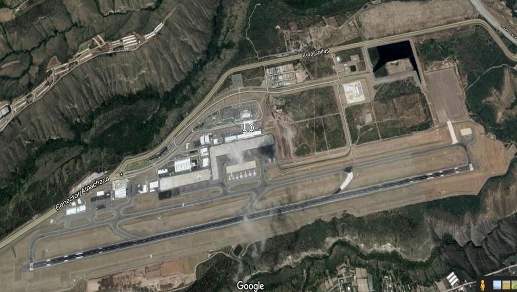


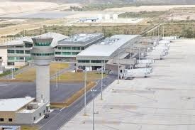
The main areas of the airport are: customs, security office, cargo area, local arrivals, international arrivals.
Description and Contacts of Key Companies
https://www.aeropuertoquito.aero/aerolineas/
|
Aeronautical Safety and Prevention |
|||
|---|---|---|---|
|
Quito |
DIRECTOR DE SEGURIDAD Y PREVENCIÓN AERONÁUTICA, Buenos Aires Oe1-53 y 10 de Agosto Of: 302 Quito, Ecuador |
||
|
Telefono |
+593 02-2552987 |
Fax |
N/A |
|
Telex |
N/A |
AFS |
N/A |
|
|
|||
|
Chief Accident Inspector |
|||
|
Quito |
DIRECTOR DE SEGURIDAD Y PREVENCIÓN AERONÁUTICA, Buenos Aires Oe1-53 y 10 de Agosto Of: 302 Quito, Ecuador |
||
|
Teléfono |
+593 02 2552987 |
Fax |
N/A |
|
Telex |
N/A |
AFS |
N/A |
|
|
Web |
||
|
Customs |
|||
|---|---|---|---|
|
Quito |
Aduanas del Ecuador Arribo internacional, junto a Attenza Duty Free |
||
|
Teléfono |
+593 2 395 4200 ext. 2369 |
Fax |
N/A |
|
Migrations |
|||
|---|---|---|---|
|
Quito |
Policía Nacional, Dirección Nacional de Migración Av. Amazonas N53 - 113 y Japón, Quito, Ecuador |
||
|
Teléfono |
+593 244-7070 |
Fax |
N/A |
|
Ministry of Foreign Affairs |
|||
|---|---|---|---|
|
Quito |
Ministerio de Relaciones Exteriores Carrión E1-76 y Av. 10 de Agosto, Quito, Ecuador |
||
|
Teléfono |
+593 299-3200 |
Fax |
N/A |
|
|
|||
|
Meteorological Service |
|||
|---|---|---|---|
|
Quito |
INSTITUTO NACIONAL DE METEOROLOGIA E HIDROLOGIA Iñaquito N36-14 y Corea, Quito, Ecuador |
||
|
Teléfono |
+593 2 3971100 |
Fax |
N/A |
|
|
Web |
||
|
Ministry of Public Health |
|||
|---|---|---|---|
|
Quito |
Av. Quitumbe Ñan y Av. Amaru Ñan |
||
|
Teléfono |
+593-2 381-4400 |
Fax |
n/a |
|
Quarantine Agriculture |
|||
|---|---|---|---|
|
Quito |
Ministerio de Agricultura, Ganadería, Acuacultura y Pesca Amazonas y Eloy Alfaro, Esquina. Edificio MAGAP, Quito, Ecuador. http://www.magap.gob.ec |
||
|
Teléfono |
+593 2 396-0100 |
Fax |
N/A |
|
National Civil Aviation Council |
|||
|---|---|---|---|
|
Quito |
Consejo Nacional de Aviación Civíl Buenos Aires Oe 1-53 y 10 de Agosto, 4to. Piso |
||
|
Teléfono |
+593 2 2900923 |
Fax |
N/A |
|
Quito International Airport – (MSIA) |
|||
|---|---|---|---|
|
Quito |
Aeropuerto Internacional de Quito - Quiport, PBX: +(593 2) 395-4200 / +(593 2) 395-4300 |
||
|
|
Tel |
+(593 2) 395-4200 ext. 2008/2010 |
|
|
Web |
Fax |
+593 2 294 4948 |
|
FBO Agents Ground Operators Quito Airport
Guayaquil FBO +593 9 9749 1740 (All Ecuador incl. Galápagos)
Jethandling FBO Ecuador +593 99 368 3885
FBO Ecuador +593 99 8838 016
SAEREO - Servicios Aereos Ejecutivos +593 2 3301 152
Ecuacentair +593 2 2818 404
Swissport Ecuador/EMSA +593 2 3957 470
Consorcio Aviation +595 98 1193 063
Talma Ecuador +593 2 281 8052
Passenger and Cargo Performance Indicator
Passenger traffic at the Mariscal Sucre International Airport in Quito registered in 2022, 4.3 million passengers transported on national and international flights, in arrivals and departures.
(Compared to 2019 traffic -before the covid-19 pandemic-, which was more than 5 million passengers, the recovery is 86.4 %.)
The Mariscal Sucre International Airport building occupies 70 hectares of a 1,500 hectare land. It was initially estimated that the 38,000 m2 international passenger terminal would be used by five million passengers per year. The 7,910 m2 national terminal, inaugurated in May 2015, has 10 departure lounges distributed over two levels. The runway is 4,100 meters long, making it the longest runway in Ecuador and any capital in South America. The runway can accommodate the largest aircraft currently available, including the Boeing 747 or the Airbus A380. The construction of a second runway is planned to meet projected demand. The control tower is 41 m high.
|
Performance for 2022 |
|||
|---|---|---|---|
|
Per Year |
Per Month |
Per Day |
|
|
Total Aircraft Movements |
N/A |
- |
- |
|
Total Passengers |
4.3 million (nationals and foreigners; arrivals and departures) |
358,000 |
12,000 |
|
Total Capacity of the Airport (MT) |
N/A |
||
|
Current Activity of the Airport (MT) |
290 677 (TM) [239 109 TM only for exports] |
24,223 |
807.5 |
|
Current use by Humanitarian Flights (UNHAS) |
N/A |
||
The cargo terminal has 13,000 m2, with 10,000 m2 of warehouses and 3,000 m2 of offices carrying out cargo activities. With 24 docks divided into 4 palletizers, the loading waiting area can accommodate up to 24 additional trucks (48 trucks can be in the loading area at the same time). This area has sophisticated scanners and cold rooms.
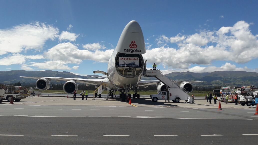
Foto: cortesía https://www.quiport.com/
Runways
This airport has one of the longest runways in Latin America at 4.1 km.
|
Runway #1 |
|
|---|---|
|
Runway Dimensions |
4,100m x 45m |
|
Orientation |
18/36 |
|
Surface |
Draining asphalt |
Helicopter Pad(s)
There is a small space at the Mariscal Sucre International Airport designated for the use of both public and private helicopters. The helicopters and their crews are under the direction of the General Directorate of Civil Aviation.
|
Helipad #1 |
|
|---|---|
|
Present |
Yes |
|
Largest Helicopter that can Land |
Mi-26 |
|
Width and Length (m) |
The helicopters are positioned in the general manoeuvring area |
|
Surface |
Asphalt |
|
Width and Length (m) |
|
|
Surface |
|
Important note: The General Directorate of Civil Aviation (DGAC) inaugurated the 'First Public Heliport in Ecuador' in 2020 at the Monjas Radar Station, in the city of Quito; which is permanently operational.
Public and private aircraft (helicopters) can land at the heliport, as established in Art. 48 of the Codification of the Aeronautical Code.
The landing site is called “Monjas Radar Heliport”, -0.23604, -78.47768 and has all the physical characteristics, visual aids, obstacle limiting surface and wind direction indicator.
Technical characteristics:
Heliport Type: Public.
Hours of Operation: HJ (Sunrise to sunset).
Platform Resistance: 8000 kg.
Visual Aids: Available.
Elevation: 3051.73 meters above sea level.
Airport Infrastructure Details
The Mariscal Sucre International Airport and the Quiport Corporation have obtained the Aerodrome certificate. The certification guarantees that the airport complies with the specifications issued by the International Civil Aviation Organization (ICAO) and the General Directorate of Civil Aviation (DGAC), regarding the facilities and their operation.
|
Customs |
Yes |
JET A-1 fuel |
Yes |
|
Immigration |
Yes |
AVGAS 100 |
Yes |
|
Terminal Building |
Yes |
Single Point Refueling |
Yes |
|
Passenger Terminal |
Yes |
Air Starter Units |
Yes |
|
Cargo terminal |
Yes |
Ground Power (mobile) |
Yes |
|
Pax Transport to Airfield |
Yes |
Ground Handling Services |
Yes |
|
Control Tower |
Yes |
Latrine Servicing |
Yes |
|
Weather Facilities |
Yes |
Fire Fighting Category (ICAO) |
9 |
|
Catering Services |
Yes |
De-icing Equipment |
Yes |
|
Base Operating Room |
Yes |
Parking Ramp Lighting |
Yes |
|
Airport Radar |
Yes |
Approach & Runway Lights |
Yes |
|
NDB |
Yes |
VOR |
Yes |
|
ILS |
Yes |
Yes |
Airport Operating Details
|
Operating Details |
|||
|---|---|---|---|
|
Maximum Sized Aircraft that can be Offloaded on Bulk Cargo |
A340-600 |
||
|
Maximum Sized Aircraft that can be Offloaded on Pallet |
AN-124 |
||
|
Total Aircraft Parking Area (m²) |
Up to 8 positions between MD11 and B747-800 |
||
|
Storage Area (m3 and MT) |
700 m2, there are three warehouses available with cold storage |
||
|
Handling Equipment |
|||
|
Elevators / Hi Loaders |
Yes |
Max Capacity (MT) |
10m |
|
Max Height (m) |
14m |
||
|
Loading Ramps |
6 |
||
|
Other Comments |
|
||
Customs Guidance
Passengers arriving in Ecuador can bring: clothing for personal use, toiletries, medications for personal use and goods for professional use, among other products with their specifications. When the goods exceed the quantity or value on the personal effects list (see link below), the passenger must pay the required taxes. Goods cannot exceed a total value of $2,000 USD. If the total value is greater, the merchandise will go to a temporary storage area and the corresponding tax procedures will be followed. The list of personal effects can be found here: https://www.aduana.gob.ec/viajeros-por-via-aerea-aeropuerto/
Storage Facilities
Centro Perecibles, Cap 250 pallets $0,070 + IVA (12%) + CCFEE
Pertally, Cap 120 pallet $0.070 + IVA (12%) + CCFEE
Aronem Cap 75 pallets $0.070 + IVA (12%) + CCFEE
WAREHOUSE: Mariscal Sucre Quito International Airport

The airport has 3 warehouses with capacity for 445 pallets, complying with all security standards, regulated by the General Directorate of Civil Aviation (DGAC). In addition, they offer cold rooms.
Airfield Costs
Ecuador is the most expensive country for airlines, because it has the highest landing and parking fees in Latin America. On average, an airplane must pay USD 1,751 to cover these items. Quito's Mariscal Sucre International Airport is one of the terminals in the region with the most expensive airport tax, which reaches USD 56.30 per passenger in 2022.
The rates are controlled by the General Directorate of Civil Aviation (DGAC) and paid in its offices and correspond to the following services, among others:
• By the use of the tracks
• For air traffic services
• For meteorological services
• For the inspection and control services of passengers and luggage
• Due to the use, by passengers, of airport areas not accessible to visitors.
• For passenger mobility services and assistance to people with reduced mobility
• Due to the parking of aircraft at airports
• Due to the use of aircraft boarding and disembarkation bridges
• For cargo loading and unloading operations
NAVIGATION CHARGES
International Cargos por Navegación y en Tierra (see Art. 4, 5, 5.1, 7, 8 and 9)
|
Charges |
Aircraft Weight - MTOW (kg) |
||
|---|---|---|---|
|
0 - 7,000 |
7,001 - 136,000 |
136,001 and over |
|
|
Navigation (per journey) USD - $ |
19.30 |
19.30 |
20.06 |
|
Landing USD - $ |
17.43 |
18.75 |
18.88 |
|
Night Landing USD - $ |
4.77 |
4.97 |
5.17 |
|
Night Take-Off USD - $ |
4.77 |
4.97 |
5.17 |
|
Parking |
2.33 |
2.43 |
2.52 |
|
Handling Charges |
N/A |
N/A |
N/A |
FUEL SERVICES CHARGES
|
Price per Litre USD - $ |
|
|---|---|
|
Jet A-1 |
$2.55 US Gallon (entre $0.67 a $0.562 x Litre) |
|
Avgas |
$2.76 US Gallon |
1 US Gallon = 3.8 Liters
Note: In Ecuador Prices vary depending on the type of flight, as can be seen in the following list (updated 08/22/2023):
Commercial AVGAS: €2.04 + VAT (21%)
AVGAS Private: €2.55 + VAT (21%)
JET-A1 Commercial: €1.80 + VAT (21%)
JET-A1 Private: €2.18 + VAT (21%)
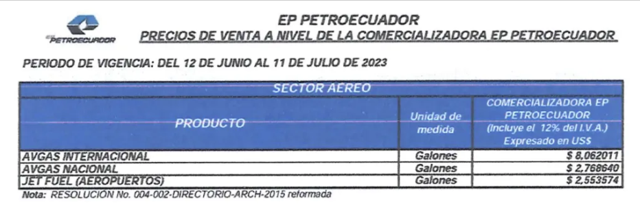
CARGO TERMINAL CHARGES
|
Import Charges |
||
|---|---|---|
|
Type of Charge |
Rate USD - $ per kg |
Comments |
|
Handling Charge |
0.26 |
|
|
Break Bulk Fee |
0.26 |
|
|
Diplomatic Mail |
10.00/ 15.00 |
Up to 100 kg |
|
Strong Room – per consignment |
0.26 |
|
|
Cold Storage Fee |
0.26 |
|
|
Delivery Outside Normal Working Hours |
N/A |
|
|
Preparation of substitute AOA – Invoice – Receipt |
N/A |
|
|
Storage per Day |
0.10 |
Grace period N/A |
|
Export |
||
|
Handling Charges – Un-palletized Cargo |
0.10 |
|
|
International Air Waybill |
40.- |
|
|
Local Air Waybill |
25.- |
|
|
Air Way Bill Amendment - Cancellation |
N/A |
|
|
Air Way Bill Documentation |
60 |
|
|
Diplomatic Mail |
25 |
|
|
Storage Charges per Day |
24 hrs 0.10 |
|
AIR-BRIDGE CHARGES
De 0 a 45’ USD 145.60
de 46’ a 180’ USD145.60 + 1.55 x (t= time in minutes)
More than 180’ USD 336.45
Security
EPMSA https://www.aeropuertoquito.gob.ec/ directs, plans, coordinates and controls security operations at the Mariscal Sucre International Airport, in accordance with national and international aeronautical regulations.
Its main task is to guarantee security at the airport through:
• AVSEC inspection for passengers and airport staff
• Inspection of checked and hand luggage.
• Handling of X-ray equipment.
• Control in metal detector arches.
• Closed circuit television control
Ecuador - 2.2.2 José Joaquín de Olmedo International Airport(Guayaquil)
Airport Overview
José Joaquín de Olmedo International Airport (Aeropuerto Internacional José Joaquín de Olmedo in Spanish) is located 5 km north of Guayaquil, the largest and most populous city in Ecuador. It has a runway of 2,790 meters (9,154 ft) and an elevation of 5 meters (16 ft). Together with the Quito airport, it handles most of Ecuador's national and international flights. During 2019, around 4 million passengers passed through the airport. The airport is capable of serving up to 7.5 million passengers per year.
The airport is on Avenida de las Américas, 5 kilometers (3.1 mi) north of downtown Guayaquil. The runway length of 2,684 meters (9,150 ft) includes a 240-meter (790 ft) displaced threshold on Runway 21 and a 100-meter (330 ft) displaced threshold on Runway 03. The airport is in the wide delta of the Guayas River, with level terrain in all quadrants. The parking platform is made of concrete about 35 cm thick and 600 meters long by 80 meters wide, which has an area of 48,000 m², has an asphalt strip for access and a vehicular street, all built in compliance with the established norms. by the General Directorate of Civil Aviation (DGAC) and the International Civil Aviation Organization (ICAO).
The Daular International Airport is a proposed development project for the Ecuadorian city of Guayaquil. The new airport is intended to replace the current José Joaquín de Olmedo Airport once completed. The master plan for the Guayaquil International Airport contemplates moving the airport facilities to a nearby 2,020 hectare plot of land. The new airport, whose construction is planned for 2024 with an estimated investment of 800 million dollars, will have three runways and will be able to serve 16 million passengers per year. However, the new Daular intercontinental airport (26 kilometers from the city) will not be inaugurated in 2024, as initially planned. The plans were affected by the drop in the number of passenger arrivals at the current José Joaquín de Olmedo airport. The entire project consists of two parallel runways of 4,100 and 2,500 meters in length and 36 boarding gates
|
Airport Location and Contact |
|
|---|---|
|
Country |
Ecuador |
|
Province or District |
Guayas |
|
Nearest Town or City |
El aeropuerto está a 7 km del centro y a 1,3 km de la Terminal Terrestre. En auto se tarda 20 minutos en llegar al centro de Guayaquil. |
|
Airport’s Complete Name |
Aeropuerto Internacional José Joaquín de Olmedo |
|
Latitude |
-2.147646 |
|
Longitude |
-79.885222 |
|
Elevation (ft and m) |
6m (19.68 ft) |
|
IATA Code |
GYE |
|
ICAO Code |
SEGU |
|
Managing Company or Airport Authority |
TAGSA – Terminal Aeroportuaria de Guayaquil S. A |
|
Management Contact Person |
Pablo Pita Gerente de Aeropuerto Guayaquil |
|
Open From (hours) |
00:00 |
|
Open To (hours) |
24:00 |
Airport Picture

The existing area of the Guayaquil International Airport is severely limited due to urban congestion.
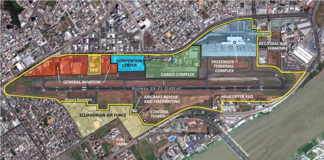

Source: www.universalweather.com Map not to scale. Not suitable for navigation purposes.
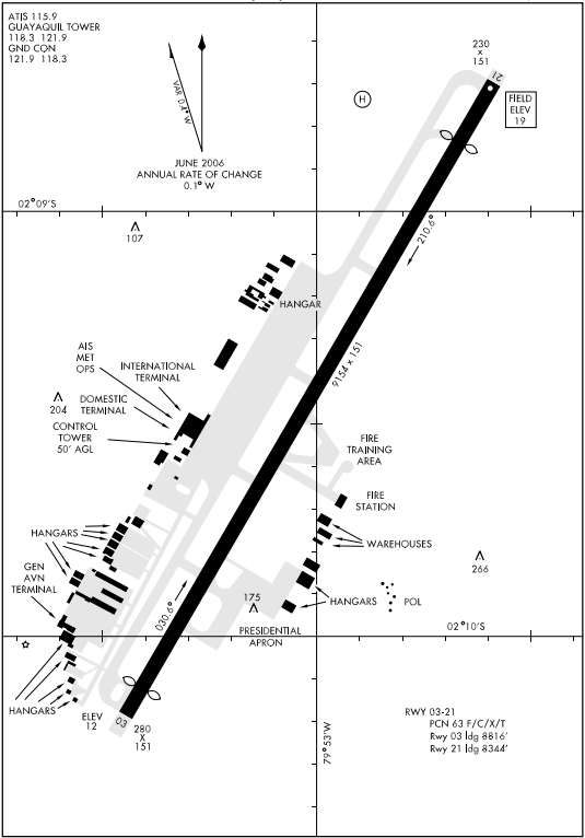
Description and Contacts of Key Companies
Aeropuerto de Guyaquil contactos generales TAGSA Contactos
Aeropuerto Contacto Entidades TAGSA Entidades
FBO Handlers, Ground Operators, Guayaquil Airport
Swissport Ecuador/EMSA +593 4 2590 266
Aeromilitec +593 4 2283 359
SAEREO - Servicios Aereos Ejecutivos +593 2 3301 152
Consorcio Aviation +595 98 1193 063
Jethandling FBO Ecuador +593 99 368 3885
FBO Ecuador +593 99 8838 016
Guayaquil FBO +593 9 9749 1740
Among the airport handling services offered by FBO aviation companies are: ground assistance to aircraft, exclusive services for passengers or crew, which can be carried out even in premises adjacent to the airport terminals, aircraft cleaning, catering, refueling, luggage loading or positioning of aircraft in hangars, among others.
Passenger and Cargo Performance Indicator
Guayaquil Airport is the second busiest airport in Ecuador after Quito's Mariscal Sucre Airport. The airport has a runway and a terminal with capacity for 7.5 million passengers per year. A new airport is currently being built 40 kilometers/25 miles from the city center, called Guayaquil Daular Airport. The airport is expected to become operational in 2026 and will have a capacity of 16 million passengers per year.
|
Performance for 2022 |
|||
|---|---|---|---|
|
Per Year |
Per Month |
Per Day |
|
|
Total Aircraft Movements |
Information not available |
- |
- |
|
Total Passengers |
3,746,554 (The airport is capable of serving up to 7.5 million pax/year) |
290,000 |
9660 |
|
Total Capacity of the Airport (MT) |
74,000 |
||
|
Current Activity of the Airport (MT) |
29,310 |
2443 |
81.4 |
|
Current use by Humanitarian Flights (UNHAS) |
N/A |
_ |
_ |
https://www.ecuadorencifras.gob.ec/institucional/home/
International entry and exit of cargo by air, period 2022 (Thousands of TM)
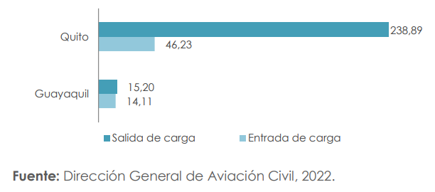
Among the most relevant aspects, the passenger traffic at the “José Joaquín de Olmedo de Guayaquil” International Airport, which registered a total of 3,477,592 people who moved through the air terminal and its cargo movements transported 33,150.25 MT ( Metric Tons).
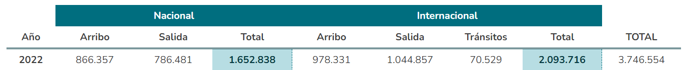
Runways
The Guayaquil airport has a single runway designated as Runway 03/21. The runway is 2,684 m long and 45 m wide and is covered with an asphalt surface. It can accommodate large aircraft such as Boeing 747, MD-11 and Airbus A340-600. The airport has a single taxiway 2,935 m long and 23 m wide. Parking spaces are planned for passenger aircraft with seven boarding bridges, eight for cargo airships and seven for general aviation aircraft.
|
Runway #1 |
|
|---|---|
|
Runway Dimensions |
9154 × 151 ft (2,684 m × 46 m) |
|
Orientation |
03/21 |
|
Surface |
All-weather asphalt that meets ICAO standards |
Helicopter Pad
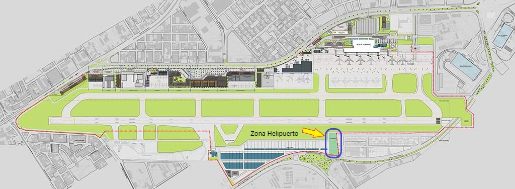
A small space in the airport is designated for the use of helicopters from public or private companies. HELO Aepto GYE Both the helicopters and the crew are controlled by the General Directorate of Civil Aviation.
|
Helipad #1 |
|
|---|---|
|
Present |
Yes |
|
Largest Helicopter that can Land |
Mi-26 |
|
Width and Length (m) |
N/A |
|
Surface |
All-weather asphalt that meets ICAO standards Concrete PCN: 88/R/C/W/T |
Airport Infrastructure Details
Infrastructure/facilities of the Guayaquil International Airport
- Tracks
- Taxiways
- Aprons
- Sewer system
- Energy and public services
- Terminals
- Air traffic control towers
- Charging facilities
- Aircraft hangars
- Fixed base operations
- Roads
- Parking facilities
In 2019, the Guayaquil Airport received from the General Directorate of Civil Aviation the “Aerodrome Certificate” with which the aeronautical authority certifies that GYE, SEGU comply with and comply with all aeronautical regulations related to the air zone or manoeuvre area specified by ICAO and the General Directorate of Civil Aviation Ecuador (DGAC).
|
Customs |
Yes |
JET A-1 fuel |
Yes |
|
Immigration |
Yes |
AVGAS 100 |
Yes |
|
Terminal Building |
Yes |
Single Point Refueling |
Yes |
|
Passenger Terminal |
Yes |
Air Starter Units |
Yes |
|
Cargo terminal |
Yes |
Ground Power (mobile) |
Yes |
|
Pax Transport to Airfield |
Yes |
Ground Handling Services |
Yes |
|
Control Tower |
Yes |
Latrine Servicing |
Yes |
|
Weather Facilities |
Yes |
Fire Fighting Category (ICAO) |
9 |
|
Catering Services |
Yes |
De-icing Equipment |
Yes |
|
Base Operating Room |
Yes |
Parking Ramp Lighting |
Yes |
|
Airport Radar |
Yes |
Approach & Runway Lights |
Yes |
|
NDB |
Yes Ident R |
VOR |
Yes Ident GYV |
|
ILS |
Yes |
Airport Operating Details
|
Operating Details |
|||
|---|---|---|---|
|
Maximum Sized Aircraft that can be Offloaded on Bulk Cargo |
Antonov AN-225, AN-124, Ilyushin IL-76 |
||
|
Maximum Sized Aircraft that can be Offloaded on Pallet |
Boeing 747-400, Airbus A340-600, B777-300 |
||
|
Total Aircraft Parking Area (m²) |
48,000 m², (600 m x 80 m) |
||
|
Storage Area (m3 and MT) |
150 MT |
||
|
Handling Equipment |
|||
|
Elevators / Hi Loaders |
Yes |
Max Capacity (MT) |
15. m |
|
Max Height (m) |
N/A |
||
|
Loading Ramps |
Yes 8 Ramps |
||
|
Other Comments |
Platforms: There are 15 parking spaces. 8 aircraft parking positions for passengers with 10 boarding bridges (these positions have variants according to the type of aircraft operated). 8 aircraft parking spaces for cargo (remote). 7 aircraft parking spaces for general aviation. |
||
Customs Guidance
|
SubDirector : |
Miguel Ángel Villacís Álava |
|---|---|
|
Dirección : |
Av de las Américas, terminal de carga aérea – edificio TCE |
|
Código Postal : |
090505 |
|
Teléfonos : |
(593-4) 2924454 |
|
Horario de atención: |
08h00 – 17h00 |
People arriving in Ecuador must consider that they can enter with clothing used by the traveler, toiletries, medications for personal use, goods for professional use, among other products with their specifications. When the assets exceed the amount or value on the list of personal effects, they are used to pay taxes. The total of these goods may not exceed $2,000. If the amount is greater, the merchandise will be placed in a temporary warehouse to continue the corresponding process.
Check the list of personal effects by entering: https://www.aduana.gob.ec/viajeros-por-via-aerea-aeropuerto/ .
Storage Facilities
|
Guayaquil – Warehousing (US$) |
||
|---|---|---|
|
Facility |
General Air |
TAGSA |
|
Cap |
50 Pallets |
30 Pallets |
|
Charges |
$0.090 + IVA (12%) + CCFEE |
$0.010 + IVA (12%) + CCFEE |
The airport has 2 warehouses with capacity for 80 pallets, complying with all the safety standards regulated by the General Directorate of Civil Aviation (DGAC). In addition, they offer cold chain cold chambers.
Airfield Costs
Ecuador is the most expensive country for airlines, because it has the highest landing and parking fees in Latin America. On average, an airplane must pay USD 1,751 to cover these items.
The airport tax charged at the José Joaquín de Olmedo Airport in Guayaquil is USD 28.50 per traveler.
The airport charges regulated rates for the following services, among others:
• By the use of the tracks
• For air traffic services
• For meteorological services
• For the inspection and control services of passengers and luggage
• Due to the use, by passengers, of airport areas not accessible to visitors.
• For passenger mobility services and assistance to people with reduced mobility
• Due to the parking of aircraft at airports
• Due to the use of aircraft boarding and disembarkation bridges
• For cargo loading and unloading operations
NAVIGATION CHARGES
International, Navigation and Land Charges Internacional Cargos Navegación
(ver Art. 4º, 5º, 5.1, 7º, 8º and 9º)
|
Charges |
Aircraft Weight - MTOW (kg) |
||
|---|---|---|---|
|
0 - 7,000 |
7,001 - 136,000 |
136,001 and over |
|
|
Navigation (per journey) USD - $ |
17.87 |
17.87 |
18.17 |
|
Landing USD - $ |
7.76 |
8.06 |
8.06 |
|
Night Landing USD - $ |
10.10 |
10.10 |
10.10 |
|
Night Take-Off USD - $ |
10.10 |
10.10 |
10.10 |
|
Parking |
1.16 |
1.22 |
1.22 |
|
Handling Charges |
N/A |
|
|
International operations
For the collection of fees for flight protection services for large and small aircraft in international operations, the following charges are established:
A) Flight Protection Rights before and after the route (approach and takeoff):
Base: Maximum takeoff weight
MTOW (In tons) Charge per ton (In USD)
More than 5.7 up to 50 2.23
From more than 50 to 100 2.32
From more than 100 to 150 2.42
From more than 150 2.52
FUEL SERVICES CHARGES
|
Price per Litre USD - $ |
|
|---|---|
|
Jet A-1 |
$2.55 US Gallon (from $0.67 to $0.562 x Litro) |
|
Avgas |
$2.76 US Gallon |
1 US Gallon = 3.8 Liters
Note: In Ecuador Prices vary depending on the type of flight, as can be seen in the following list (updated 08/22/2023):
AVGAS Commercial: €2.04 + VAT (21%)
AVGAS Private: €2.55 + VAT (21%)
JET-A1 Commercial: €1.80 + VAT (21%)
JET-A1 Private: €2.18 + VAT (21%)

At the José Joaquín de Olmedo Airport terminal in Guayaquil, about 162,000 gallons of JET A-1 fuel are pumped daily, the same fuel used in the aeronautical industry and designed for airplanes powered by gas turbine engines. The fuel travels underground through pipes from Plant 1 of Ecuafuel to the aircraft platforms, where a network of hydrants is installed. From this network, the supply equipment is attached to the wing of the aircraft where the fuel tanks are located. operation is called Into Plane.
CARGO TERMINAL CHARGES
|
Import Charges |
||
|---|---|---|
|
Type of Charge |
Rate USD - $ per kg |
Comments |
|
Handling Charge |
0.09 |
The indicated values are referential, it is necessary to request a current quote |
|
Break Bulk Fee |
0.09 |
|
|
Diplomatic Mail |
0.09 |
|
|
Strong Room – per consignment |
0.09 |
|
|
Cold Storage Fee |
0.09 |
100 kg max. |
|
Delivery Outside Normal Working Hours |
N/A |
|
|
Preparation of substitute AOA – Invoice – Receipt |
N/A |
|
|
Storage per Day |
0.09 |
N/A |
|
Export |
||
|
Handling Charges – Un-palletized Cargo |
0.09 |
|
|
International Air Waybill |
40.00 |
|
|
Local Air Waybill |
25.00 |
At market value. Consult in advance with the shipper or agent to establish the current value |
|
Air Way Bill Amendment - Cancellation |
N/A |
|
|
Air Way Bill Documentation |
57.00 |
|
|
Diplomatic Mail |
25.00 |
|
|
Storage Charges per Day |
24 hrs 0.03 |
|
AIR-BRIDGE CHARGES
From 0 a 45’ De 46’ a 180’ More than 180’
USD 134 134.57 + 1.45 x (t=time in mins) 335.91
Security
TAGSA, the managing entity of the Guayaquil Airport, through qualified technical personnel, carries out inspections and controls in the different areas of the airport to prevent risk factors that may generate accidents or affect the health of workers, as part of Health and Safety. . Management System of the José Joaquín de Olmedo International Airport, according to the legal framework
Rescue and firefighting:
• Protection category: 9.
• Critical aircraft: Boeing 767-300.
• Operational personnel: Aeronautical firefighters, radio operators, SEM (Emergency Medical Service) personnel.
• 24 hours, 365 days a year.
Operational equipment:
• 2 OSHKOSH T-12 brand self-pumps: Capacity of 3170gl of water and 410gl of AFFF.
• 1 OSHKOSH T-1500 brand self-pump: Capacity of 1500gl of water, 190gl of AFFF and 500lb of PQS.
• 1 OSHKOSH T-2500 brand self-pump: Capacity of 2500gl of water, 410gl of AFF and 500lb of PQS; It has a hydraulic arm (Snoozle) that penetrates the aircraft fuselage, unique in South America.
• 1 Ford-350 rapid intervention team: Capacity of 500lbs of PQS, 94gl of water and 6gl of 6% foam concentrate.
• 1 logistical support van.
• 1 all-terrain logistical support vehicle in charge of towing the triage trailer
• 2 ambulances
• 1 triage trailer equipped with first aid kits, oxygen, stretchers, etc. to serve our critical aircraft considering up to 250 passengers
Ecuador - 2.2.3 Eloy Alfaro International Airport (Manta)
Airport Overview
The “Eloy Alfaro” International Airport serves the city of Manta, Ecuador (IATA: MEC, ICAO: SEMT). The airport is a mixed-use facility, operating civilian and military air services. It is designated as the alternate airport to Quito and Guayaquil airport. At present, this Manabi airport remains operational with the Quito-Manta-Quito routes, with the service of the Latam and Avianca Airlines. Recently remodeled after a long wait after the 2016 earthquake the Manta International Airport has a new 5,000 square meter terminal, a new nine-story high control tower, parking for more than 130 vehicles, an aircraft parking platform of more than 14,000 square meters, a new access road and additional works that became operational in February 2021 with passengers on the Quito - Manta - Quito route.
Korea Airports Corporation KAC signed a contract with the Ecuadorian government at the end of June 2021 to take on full ownership of Manta Airport and the incorporation for the next 30 years (2021-2050). This will be KAC’s first overseas airport among the 15 airports the firm operates.
The airport, also known as Eloy Alfaro Air Base, is the fourth-busiest airport in Ecuador. Due to its strategic location, the Eloy Alfaro Air Base and the Manta Naval Air Station operate on the runway of this airport. The military air force base is located in an area attached to the provisional passenger air terminal of the International Airport. A portion of the airport was used until July 2009 by the Air Forces Southern Air Force component of the United States Southern Command, for operations against drug trafficking in north western South America. Buildings and platforms were built for the use of the US military and runway 05/23 was rebuilt using more resistant material in order to support the operations of the world's heaviest aircraft, both civil and military.
Later the Ecuador and U.S. governments did not to renew the military airport agreement that allows access and use of the base and in 2009 US forces left the facilities.
|
Airport Location and Contact |
|
|---|---|
|
Country |
Ecuador |
|
Province or District |
Manabi |
|
Nearest Town or City with Distance from Airport |
Manta (2.5 km) |
|
Airport’s Complete Name |
Eloy Alfaro International Airport |
|
Latitude |
-0.953341 |
|
Longitude |
-80.683924 |
|
Elevation (ft and m) |
15 m / 48 feet |
|
IATA Code |
MEC |
|
ICAO Code |
SEMT |
|
Managing Company or Airport Authority |
Direccion General De Aviacion Civil Managing Company: Korea Airports Corporation (KAC) 78, Haneul-gil, Gangseo-gu, Seoul, 07505 Landline 1661-2626 |
|
Management Contact Person |
Chang-wan Son, CEO Korea Airport Corp. |
|
Open From (hours) |
TBD |
|
Open To (hours) |
- |
Airport Picture
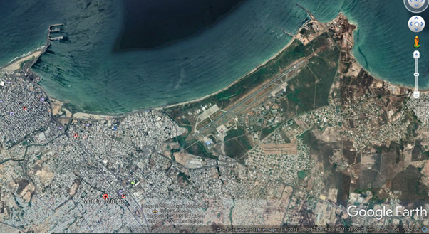
Source: www.eluniverso.com, passenger terminal at Manta airport. Photo: Neptalí Palma
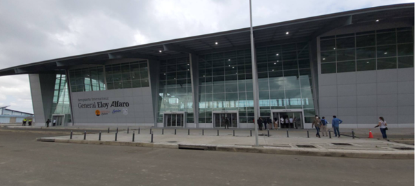
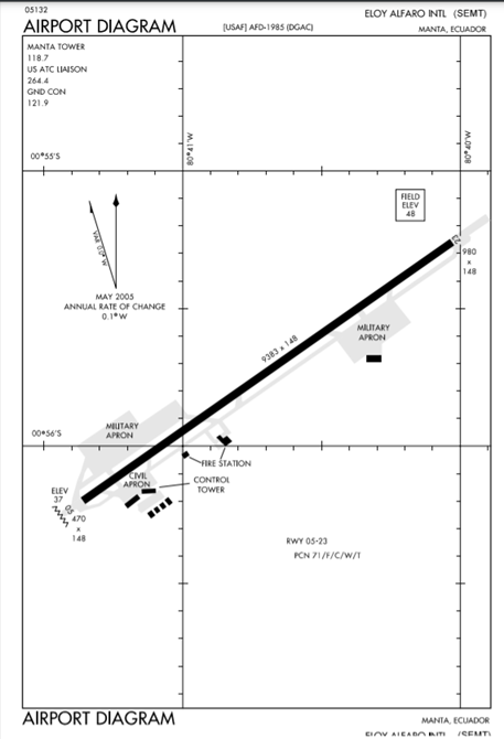
Description and Contacts of Key Companies
- The Korea Airports Corporation (KAC) is a Korean state firm that manages 15 international airports, including Manta International Airport.
- UN789 Ocean Airway. This is the name given to the Manta - Tahiti Airway. This airway connects the Asia Pacific region to the South American Region; that is, from Tahiti (French Polynesia) - Tahiti International Airport (NTAA), to Ecuador - Manta International Airport (SEMT) on the northwest coast of Ecuador, being the most salient geographical point towards Asia from South America.
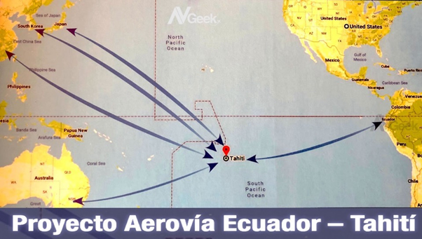
Source: revistademanabi.com Joselías Sánchez Ramos, 2021
Passenger and Cargo Performance Indicator
Not available.
Runway
|
Runway #1 |
|
|---|---|
|
Runway Dimensions |
2860 m X 45 m |
|
Orientation |
05/23 |
|
Surface |
Asphalt |
| Condition | Good |
The runway 05/23 was rebuilt using more resistant material in order to support the operations of the world's heaviest aircraft, both civil and military.
Helicopter Pad(s)
Yes. Manta Naval Air Station and Base Militar Manta. Information is unavailable.
Airport Infrastructure Details
Recently remodeled after a long wait after the 2016 earthquake, the Manta International Airport has a new 5,000 square meter terminal, a new nine-story high control tower, parking for more than 130 vehicles, an aircraft parking platform of more than 14,000 square meters, a new access road and additional works that became operational in February 2021 with passengers on the Quito - Manta - Quito route.
Airport Operating Details
|
Operating Details |
|||
|---|---|---|---|
|
Maximum Sized Aircraft that can be Offloaded on Bulk Cargo |
Antonov AN-225, AN-124, Ilyushin IL-76 |
||
|
Maximum Sized Aircraft that can be Offloaded on Pallet |
Boeing 747-400, Airbus A340-600, B777-300 |
||
|
Total Aircraft Parking Area (m²) |
N/A |
||
|
Storage Area (m3 and MT) |
N/A |
||
|
Handling Equipment |
|||
|
Elevators / Hi Loaders |
N/A |
Max Capacity (MT) |
N/A |
|
Max Height (m) |
N/A |
||
|
Loading Ramps |
N/A |
||
|
Other Comments |
Airport construction is in progress. |
||
Storage Facilities
N/A
Airfield Costs
Navigation Charges
N/A
Fuel Service Charges
The only fuelling station is Ecuafuel , the station belongs to PETROECUADOR, an Ecuadorian state company. In this station large amount of fuel is available.
|
Price per Litre USD - $ |
|
|---|---|
|
Jet A-1 |
0.56 (*) |
|
Avgas |
0.13 (*) |
(*) The above are referential prices and were obtained from Petrocomercial information (GoE fuel supplier). In the private sector, each retailer may vary its prices.
Cargo Terminal Charges
Airport construction is in progress.
Air-Bridge Charges
N/A
Security
N/A
Ecuador - 2.2.4 Mariscal La Mar International Airport (Cuenca)
Airport Overview
Mariscal La Mar International Airport (IATA code: CUE, ICAO code: SECU), also called Mariscal Lamar Airport or Cuenca Airport, is considered a national cross-border terminal located within the urban perimeter of the city of Cuenca, providing its services to the city of Cuenca, Quito and Guayaquil in Ecuador. Local flights take 35 minutes from Quito and 20 minutes from Guayaquil.
Currently, and due to the unexpected growth of the city and its progressive expansion, the airport has been surrounded by industrial and residential areas, which produces tension between the neighbors and the airport entities, due to the constant discomfort due to the noise generated by the planes at the airport. take off and landing. Furthermore, expansions are made impossible due to geography and the surrounding populations; This puts entities in a serious dilemma, since the airport and its runways need to be expanded again due to their air traffic.
The airport has carried out several works that have allowed it to maintain its operations safely and up to date with current aeronautical trends. For example, new satellite and GPS landing procedures have been implemented in approach systems that allow more environmentally friendly operations with lower visibility. It also has an ILS landing system, PAPI and runway lights.
Master Plan and International Airport Certification
In 2022, the Municipality of Cuenca carried out the comprehensive rehabilitation of the runway and movement area of the Mariscal La Mar airport, as well as the repowering and construction of a new drainage system; the reconstruction of electrical circuits, the change to LED lights and the horizontal signage currently in use (The current landing assistance system (ILS) was installed in 2002, which allowed the airport to extend its hours and increase the number of landings in bad weather). These improvements, according to CORPAC, are part of a certification process that this aerodrome seeks and is included in the strategic, institutional and master plans.
Other mandatory improvements are the implementation of immigration and customs measures for daily flight control, which would currently be limited by the physical spaces of the airport.
Incentives
Corpac considers that despite the current geographical and demographic limitations, the Cuenca Airport is an interesting option for companies that operate smaller aircraft (e.g. Dash8 20,000 kg, Fokker F28 30,000 kg), aircrafts that require a shorter runway length and parking platform In this perspective, the government of Ecuador grants to terminals not commissioned in private concession, among others:
- A 40% fuel subsidy for international airlines and,
- The reduction of the EcoDelta* rate from US$50 to US$5
(*) The Ecodelta rate, of USD 50, is charged on international tickets from Ecuador to abroad. On the other hand, the Ecuador Tourist Power tax is charged on international tickets from abroad to Ecuador.
About International Airport Certification
Within the framework of the airport's development and certification master plan, three specific points should be highlighted at this time:
- Anti-narcotics and migration units are installed at the Mariscal La Mar International Airport. https://www.ministeriodelinterior.gob.ec/aeropuerto-de-cuenca-se-internacionaliza-e-implementa-unidades-de-antinarcoticos-y- migration/ September 14, 2023
- However, Corpac recognizes that, if certification is obtained, the operation of international airlines in the city will be conditioned by three limitations that the airport has. The first is the size of the track, just 1,900 meters long. The second consists of the limited space on both sides of the track of just 50 and 80 meters. Ecuadorian regulations say that airfields must have 140 meters of space on the sides of the runway. Third, the location of the air terminal in a densely populated area and in the future the impossibility of expanding it due to the highly limiting mountainous geography of the area.
- The DGAC Ecuador, at the time of publication of this document, considers the Mariscal La Mar Airport, Cuenca as a National Aerodrome.

|
Airport Location and Contact |
|
|---|---|
|
Country |
Ecuador |
|
Province or District |
Azuay |
|
Nearest Town or City |
Cuenca (3.8 km) |
|
Airport’s Complete Name |
Mariscal La Mar International Airport |
|
Latitude |
-2.889678 |
|
Longitude |
-78.987095 |
|
Elevation (ft and m) |
2.532 m / 8.306 feet |
|
IATA Code |
CUE |
|
ICAO Code |
SECU |
|
Managing Company or Airport Authority |
Corporación Aeroportuaria de Cuenca (CORPAC) http://www.aeropuertocuenca.ec/ |
|
Management Contact Person |
José Luis Aguilar Executive Director (May 2023) (Experience: Ministry of Transportation and Public Works, deputy minister of transport services) 593) 7286-7120 / (593) 72862095 |
|
Open From (hours) |
From Saturday to Thursday 06:00 a.m. to 9:30 p.m. Friday from 6:00 a.m. to 10:00 p.m. |
|
Open To (hours) |
_ |
Airport Picture
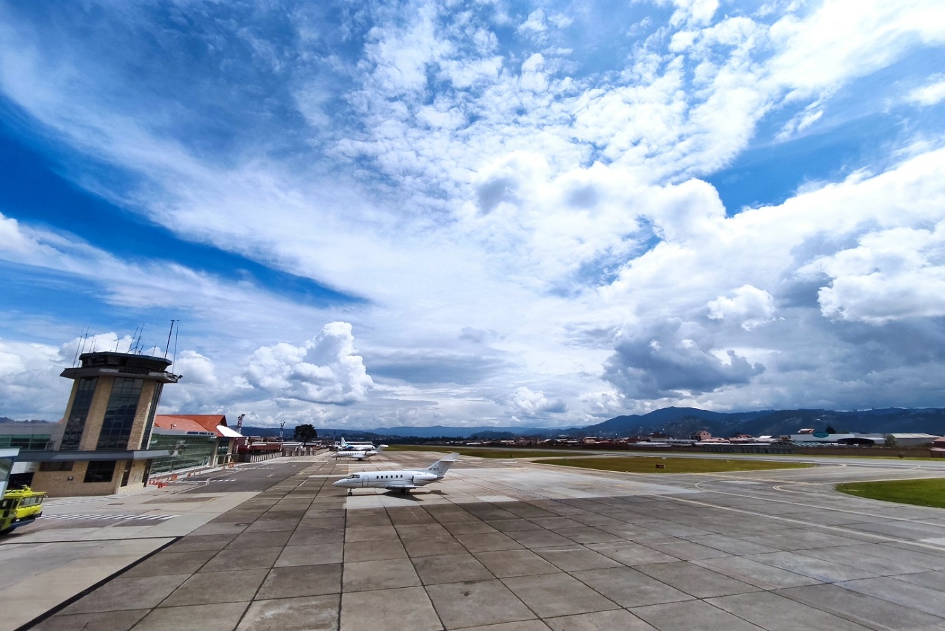
Photo: www.aeropuertocuenca.ec
The airport is located 2,532 meters above sea level with a reference temperature of 24 degrees Celsius. The airport's operation starts at 11:00 UTC to 02:00 UTC every day of the year, that is, 6:00 and ends at 21:00 in local time UTC-5.

Sourec: @dgac_ecuador
Description and Contacts of Key Companies
Corporate Contacs CORPAC
|
OFFICER |
AREA |
|
|---|---|---|
|
Dr. José Luis Aguilar |
Executive Director |
|
|
Ing. Italo Mogrovejo |
Director of Aerodrome Operations, Engineering and Infrastructure |
|
|
Ing. Marcela Bravo |
Financial Administrative Director |
|
|
Ab. Paul Vazquez |
Legal advisor |
|
|
Lcda. Marcia Rodas |
Security |
FBO Handlers, Ground Operators, Cuenca Airport*
International Flight Planning Solutions- IFPLS
(*) With own operations or service is provided through third parties
Passenger and Cargo Performance Indicator
|
Performance for 2022 |
|||
|---|---|---|---|
|
Per Year |
Per Month |
Per Day |
|
|
Total Aircraft Movements |
N/A |
- |
Cuenca-Quito 52 flights/week Cuenca-Guayaquil 4 flights/week |
|
Total Passengers |
196.530 (1) (2021 103.777) |
16378 |
546 |
|
Total Capacity of the Airport (MT) |
(2) |
||
|
Current Activity of the Airport (MT) |
(3) |
||
|
Current use by Humanitarian Flights (UNHAS) |
No |
||
(1) National Institute of Statistics, Consulted on September 6, 2023
(2) Cargo flights are not planned. The terminal, relatively small, has 5,126 m² of construction on 2 floors, being a completely modern building.
(3) The airport has a rigid pavement platform 250 m long by 50 m wide, parallel to 70 m from the runway axis.
Runways
Total area of 68,400 square meters. At the Northeast and Southwest ends there is an additional area (called ears) of 18,446.00 m². Therefore, the actual total surface area of the track is 86,846.00 m². Headland threshold 0-5: S 02º53``41.0” and W 78º59``28.1” with an elevation of 2531.73 meters (8306.2 feet) above sea level. Head threshold 2-3: S 02º53``03.1 and W 78º58` 39.06” with an elevation of 2516.45 meters (8256.07 feet) above sea level.
The taxiway is built on flexible pavement, parallel to the runway at a distance of 78m. and communicates with the 0-5 head of the airport with a length of 580 m. with a width of 18 m.

Source: zbordirect.com/es/airport/cuenca-cue
Currently, with the growth of the city, the airport is located within the northern area of the city, completely surrounded by it, in a commercial, industrial and residential area. This generates inconvenience, especially due to noise, safety and efficiency problems for airlines and users. Furthermore, although the passenger terminal has been constantly updated and is a modern building, the runway can no longer be expanded because on one side there is a ravine and on the other side several houses and businesses.
|
Runway #1 |
|
|---|---|
|
Runway Dimensions |
1900m x 36m (6,234 × 118 ft) TRACK STRIP: 2020m x 110m SLOPE: ±0.82% |
|
Orientation |
24 N y 06 S |
|
Surface |
Asphalt, flexible |
RunwayRepairs (Nov 2021):
Repair of irregularities on the runway surface, due to the asphalt layer reaching its useful life.
Repair and sealing of cracks (potholes on runway).
Repair in the footprint groove.
Definitive demarcation of the manoeuvre area and movement area with new painting and signage.
Taxi way:
The taxiway is built on flexible pavement, parallel to the runway at a distance of 78 m and communicates with the airport's 0-5 headland with a length of 580 m and a width of 18 m.
CUE conditions:
4.5 km Visibility
250m Ceiling
VFR THRESHOLD 05
IFR THRESHOLD 23 PRN APPROACH THRESHOLD 05
Runway lighting:
12 PAPIS Lights, header 23.
8 PAPIS lights, header 05.
16 Green lights, runway start 05/23.
16 Red lights, end of runway 05/23.
The airport has a rigid pavement platform 250 m long by 50 m wide, parallel to 70 m from the runway axis.
Airport Infrastructure Details
The relatively small terminal has 5,126 m² of construction on 2 floors, being a completely modern building. Currently, with the growth of the city, the airport is located within the northern area of the city, completely surrounded by it, in a commercial, industrial and residential area. This generates inconvenience, especially due to noise, safety and efficiency problems for airlines and users.
|
Customs |
Yes |
JET A-1 fuel |
Yes |
|
Immigration |
Yes |
AVGAS 100 |
Yes |
|
Terminal Building |
Yes |
Single Point Refueling |
Yes |
|
Passenger Terminal |
Yes |
Air Starter Units |
Yes |
|
Cargo terminal |
No cargo flights |
Ground Power (mobile) |
Yes |
|
Pax Transport to Airfield |
No |
Ground Handling Services |
Yes |
|
Control Tower |
Yes |
Latrine Servicing |
Yes |
|
Weather Facilities |
Yes Meteo CUE |
Fire Fighting Category (ICAO) |
|
|
Catering Services |
No |
De-icing Equipment |
No |
|
Base Operating Room |
Yes |
Parking Ramp Lighting |
N/A |
|
Airport Radar |
Yes |
Approach & Runway Lights |
Yes Balizaje CUE |
|
NDB |
Yes |
VOR |
|
|
ILS |
Yes |
Radio aid for navigation and landing: Radioayuda CUE
Airport Operating Details
|
Operating Details |
|
|---|---|
|
Maximum Sized Aircraft that can be Offloaded on Bulk Cargo |
No cargo flights |
|
Maximum Sized Aircraft that can be Offloaded on Pallet |
No cargo flights |
|
Total Aircraft Parking Area (m²) |
The airport has a rigid pavement platform 250 m long by 50 m wide, parallel to 70 m from the runway axis. |
|
Storage Area (m3 and MT) |
No |
Storage Facilities
CUE Airport does not receive cargo flights
Airfield Costs
The Ecodelta rate, of USD 50, is charged on international tickets from Ecuador to abroad. On the other hand, the Ecuador Tourist Power tax is charged on international tickets from abroad to Ecuador.
Ecuador is generally the most expensive country for airlines, because it has the highest landing and parking fees in Latin America. On average, an airplane must pay USD 1,751 to cover these items.
The airport charges regulated rates for the following services, among others:
• By the use of the tracks
• For air traffic services
• For meteorological services
• For the inspection and control services of passengers and luggage
• Due to the use, by passengers, of airport areas not accessible to visitors.
• For passenger mobility services and assistance to people with reduced mobility
• Due to the parking of aircraft at airports
FUEL SERVICES CHARGES
|
Price per Litre USD - $ |
|
|---|---|
|
Jet A-1 |
2.114 / US Gallon ; 0.562 / Litre |
|
Avgas |
N/A |
Video restart of fuel supply service at CUE airport: https://youtu.be/_5UJGaPUy3E
Corpac – FAYTA* http://www.fayta.com.ec/combustibles/ : Fuel types: JET A-1
2 tanks with a capacity of 5000 and 10000 gallons
5 tanks with a capacity of 50 thousand gallons
Condition: Operational
(*)FAYTA S.A. is an Ecuadorian company that markets aviation fuels (Turbo Fuel JP1 and AVGas 100/130), with more than 10 years of experience in the market, has current permits and contracts for the sale and distribution of aviation fuels.
Air Bridge
The airport does not have this equipment
Navigation Charges
Internacional, Cargos por Navegación y en Tierra Internacional Cargos Navegación
(see Art. 4º, 5º, 5.1, 7º, 8º y 9º)
Security
PROHIBITED ITEMS
a) Light firearms, firearms and other projectile-launching devices designed to cause serious injury by launching a projectile, or which can be confused with such devices
b) Stunning devices specifically designed to stun or immobilize:
c) Pointed or sharp-edged objects that can be used to cause serious injury:
d) Work tools that can be used to cause serious injury or threaten the operational safety of the aircraft:
e) Blunt instruments that can be used to cause serious injuries by striking:
f) Explosives and flammable substances and devices that can be used to cause serious injury or threaten the operational safety of the aircraft:
The regulations for obtaining, granting and using the airport circulation card at the Mariscal La Mar airport in the city of Cuenca indicate that: Any person who performs tasks or functions in the aeronautical field, as well as performs commercial acts or provides services. in the restricted security areas of the Mariscal La Mar airport in the city of Cuenca, you must possess the Airport Circulation Card, issued by the Cuenca Airport Corporation.
The TCA is the only document that allows its holder to enter certain sector(s) of the airport facility, according to the area to which they are authorized and which is displayed on the card in a bar of colors and numbers.
Objective: Guarantee the safety of passengers, aircraft users and airport facilities through the application of a control mechanism, with the issuance of the Airport Circulation Card, which regulates the entry and stay of people in the aeronautical part or in the different restricted security areas of the Mariscal Lamar airport in the city of Cuenca.
RESCUE AND FIRE FIGHTING SERVICE
|
1 |
Working Hours |
MON-SUN 1100-0300 |
|
2 |
Fire Fighting Category |
CAT 6 |
|
3 |
Rescue Equipment |
1 OSHKOSH T-1500 1500 gallons of water, 195 gallons of AFFF and 500 pounds of P.Q.S. 1 ROSEMBAUER 3000 3000 gallons of water, 400 gallons of AFFF and 500 pounds of P.Q.S. |
|
4 |
Ability to remove disabled aircraft |
Liability and removal of an aircraft unused correspond to the registered owner or to the operator affected by his own means or agreement with local companies. |
|
5 |
Remarks |
N/A |
Ecuador - 2.2.5 Chachoan National Airport (Ambato)
Airport Overview
Chachoán airport is only operational during the day.
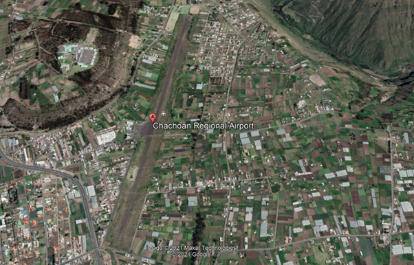
|
Airport Location and Contact |
|
|---|---|
|
Country |
Ecuador |
|
Province or District |
Tungurahua |
|
Nearest Town or City |
Ambato (6km) |
|
Airport’s Complete Name |
Aeródromo Nacional “Chachoán” |
|
Latitude |
-1.211944 |
|
Longitude |
-78.57444 |
|
Elevation (ft and m) |
8,391 ft / 2,558 m |
|
IATA Code |
ATF |
|
ICAO Code |
SEAM |
|
Managing Company or Airport Authority |
Ministry of National Defense Directorate of Specialized Technical Consulting (DATE) Ecuadorian Air Force |
|
Management Contact Person |
|
|
NGO and/or UN Presence at Airport? |
NO |
Observations: Prior permission from the Ministry of National Defence is required for civil aircraft operations.
Runway
|
Runway #1 |
|
|---|---|
|
Runway Dimensions |
1,925 m x 25 m Runway Side Strip 2042 x 150 m |
|
Runway Orientation |
01/19 |
|
Runway Surface |
SIWL 13636 DW 17273 Pavement, asphalt |
|
Runway Condition |
N/A |
Airport Infrastructure Details
|
Infrastructure |
|||
|---|---|---|---|
|
Passenger / Cargo Security Screening |
No |
Runway Lighting |
No |
|
Refueling Capacity |
No |
Ground Handling Services |
No |
|
Air Traffic Control |
N/A |
Fire Fighting Equipment |
N/A |
|
Weather Information |
Yes 1 |
Aircraft Parking Space |
No |
|
Navigation Aids |
No 2 |
Perimeter Fencing |
No |
|
Windsock |
Yes |
|
|
- Meteo Ambato: INFORMACION_METEOROLOGICA_PROPORCIONADA Ambato
- Nav Aid , NO. Source RADIOAYUDAS_PARA_LA_NAVEGACI.C3.93N_Y_EL_ATERRIZAJE Ambato
Helipad
Si , _AREA_DE_ATERRIZAJE_PARA_HELICOPTEROS Ambato
Fuel Services Charges
N/A
|
Price per Litre USD - $ |
|
|---|---|
|
Jet A-1 |
N/A |
|
Avgas |
N/A |
Royalties / Non Objection Fees (NOFs)
N/A
Ecuador - 2.2.6 Seymour National Airport (Baltra, Galapagos)
Airport Overview
Baltra Seymour Airport, also known as Baltra Airport - Galapagos Islands, is the main airport of the Galapagos Islands archipelago in Ecuador. Seymour Airport is located on the island of Baltra, 23 meters above sea level.
The airport is located 36 km (22 miles) north of Puerto Ayora, capital and main town of the island of Santa Cruz, part of the Galapagos archipelago.
Baltra receives small planes with flights from the main Ecuadorian cities. Some of the airport's main services are X-ray control to prevent trafficking of endemic species, biosecurity and quarantine agencies, medical service, migration, catering, agro-quality and rapid security clearance. In the event of any emergency, the fire station and ambulances have a prompt response.

Entry requirements to the Galapagos Islands by air
All people who want to enter the island province, tourists or residents, have the same requirements:
People over 16 years of age must present a COVID-19 vaccination card valid for at least 14 days after completing the schedule. In addition, the negative result of a qualitative real-time RT-PCR test, carried out up to 72 hours prior to boarding to Ecuador.
Minors between 2 and 16 years of age must present the negative result of a real-time qualitative RTPCR test carried out up to 72 hours prior to boarding.
In the case of national or foreign tourists, they must also present the transit control card issued by the Government Council of the Special Regime of Galapagos, eliminating the safe conduct managed by a tour operator or by an accommodation regulated by the Ministry of Tourism. This provision exempts the safe conduct for tour leaders established in article 12 of the Tourist Guidance Regulations for the Special Regime of the Province of Galapagos.
Ref. DGAC Galápagos por Vía Aérea

Note: Seymour Airport is only operational during the day.
|
Airport Location and Contact |
|
|---|---|
|
Country |
Ecuador |
|
Province or District |
Islas Galápagos |
|
Nearest Town or City |
Baltra |
|
Airport’s Complete Name |
Aeródromo Nacional “Seymour” |
|
Latitude |
-0.444840 |
|
Longitude |
-90.270334 |
|
Elevation (ft and m) |
77 feet / 23 m |
|
IATA Code |
GPS |
|
ICAO Code |
SEGS |
|
Managing Company or Airport Authority |
Aeropuertos Ecológicos de Galápagos - ECOGAL S.A. https://www.ecogal.aero/es/
|
|
Management Contact Person |
Jorge Rosillo Gerente General Jefatura Aeropuerto Baltra Aeródromo de Baltra |
|
NGO and/or UN Presence at Airport? |
No |
Passenger movement at Seymour Airport 2022 231,782 pax. (73,000 pax in 2020)
Runway(s)
|
Runway #1 |
|
|---|---|
|
Runway Dimensions |
2,400 m x 35 m |
|
Runway Orientation |
14/32 |
|
Runway Surface |
65/F/D/X/U Pavement Asphalt |
|
Runway Condition |
Good |
Platform:
Surface: NE Sector: Pavement SW Sector – Concrete, Resistance: PCN: 45/R/D/X/T
Width, surface and resistance of taxiways:
Width: TWY A 59.82 M TWY B 31.77 M
Surface: TWY A Concrete TWY B Pavement
Resistance: TWY A and TWY B
PCN: 65/F/C/X/T
Airport Infrastructure Details
|
Infrastructure |
|||
|---|---|---|---|
|
Passenger / Cargo Security Screening |
Yes |
Runway Lighting |
No |
|
Refueling Capacity |
No |
Ground Handling Services |
No |
|
Air Traffic Control |
Yes |
Fire Fighting Equipment |
Yes 4 |
|
Weather Information |
Yes 1 |
Aircraft Parking Space |
Yes 3 |
|
Navigation Aids |
Yes 2 |
Perimeter Fencing |
No |
|
Windsock |
Yes |
|
|
(1) Meteo Aeropuerto Seymour Meteo Aeropuerto Seymour Teléfono: Teléfono: 593 2 2947400 ext. 2610
(2) Aeronavegación RADIOAYUDAS NAVEGACION ATERRIZAJE Galápagos
(3) Plataforma: Superficie : Sector NE: Pavimento Sector SW – Concreto, Resistencia : PCN: 45/R/D/X/T
(4) Cat 6 Para situaciones de emergencia se interviene mediante convenio entre la Jefatura de aeropuerto y las compañías locales. Equipo de salvamento: 1 OSHKOSH T-3000, 3000 galones de agua, 420 galones de AFFF 500 libras de P.Q.S. Ante cualquier emergencia el parque de bomberos y ambulancias tienen una pronta respuesta.
Helipad
Yes Aterrizaje HELO Galápagos Helipad Strength: Concrete PCN: 45/R/D/X/T
Fuel Services Charges
N/A
|
Price per Litre USD - $ |
|
|
Jet A-1 |
N/A |
|
Avgas |
N/A |
Royalties / Non Objection Fees (NOFs)
N/A
Ecuador - 2.2.7 Francisco de Orellana National Airport (Coca)
Airport Overview
The Francisco de Orellana Airport is located in the capital of the province of Orellana, also known by the name of Coca, due to its proximity to the Coca River. With the General Directorate of Civil Aviation of Ecuador as its operator, it is considered a Type B airport, because it carries out both cargo and passenger flights; In addition, it has a completely paved track 2,060 meters long × 27 meters wide.
The airport is located at an elevation of 834 feet (254 m) above mean sea level. It has a runway designated 15/33 with a flexible pavement surface measuring 6,760 by 90 feet (2,060 × 27 m); and a capacity to receive aircraft weighing more than 100,000 pounds.
Some of the airport's main services are: medical service and expedited security clearance. In the event of any emergency, the fire and ambulance station has a prompt response.
Brief History
The airport was built between 1958 and 1959 by the Vicariate of Aguarico, an ecclesiastical community that has contributed to the development of the region.
With an initial length of 600 meters, and only grass, which only allowed it to operate in summer; It was used to evacuate patients with tropical diseases typical of the area, given that there were no roads that connected this area with the rest of the country. With oil exploitation, the Texaco Company extended the length to a thousand meters, and added a mixture of ballast and crude oil, which gave it a characteristic similar to pavement.
|
Airport Location and Contact |
|
|---|---|
|
Country |
Ecuador |
|
Province or District |
Orellana |
|
Nearest Town or City |
Coca (5 km) |
|
Airport’s Complete Name |
Aeródromo Nacional “Francisco de Orellana” |
|
Latitude |
-0.463693 |
|
Longitude |
-76.985308 |
|
Elevation (ft and m) |
834 feet / 254 m |
|
IATA Code |
OCC |
|
ICAO Code |
SECO |
|
Managing Company or Airport Authority |
General Directorate of Civil Aviation “Francisco de Orellana” National Aerodrome * |
|
Management Contact Person |
+593 6 2883518 |
|
NGO and/or UN Presence at Airport? |
N/A |
(*) The General Directorate of Civil Aviation has been in charge of administration since 1988, and permanently continues with expansion and improvements to the runway and apron, and air terminal.
Passenger movements at Francisco de Orellana Airport 2022: 48,862 pax. (The airport has an installed capacity of up to 100,000 pax / year)
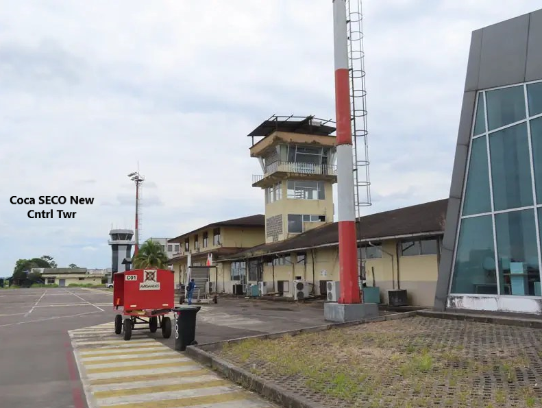
Photo https://www.nlarenas.com/2022/08/aeropuerto-francisco-de-orellana-el-coca/

Runway
|
Runway #1 |
|
|---|---|
|
Runway Dimensions |
2300m x 30m |
|
Runway Orientation |
16/34 |
|
Runway Surface |
Pavement Asphalt :PCN 39/F/C/Y/T |
|
Runway Condition |
N/A |
- 180° turns prohibited on RWY 16/34
- Receives aircraft weighing more than 100,000 pounds/45 tons
Airport Infrastructure Details
With the remodelling carried out in 2018, the new terminal has 4,780 square meters of space and the apron with a capacity for up to 7 aircraft. Additionally, the airport has a landing strip 2,300 meters long by 30 meters wide, a boarding hall for more than 400 passengers, a new control tower 19.7 meters high, counter rooms and service hangars.
|
Infrastructure |
|||
|---|---|---|---|
|
Passenger / Cargo Security Screening |
Yes |
Runway Lighting |
Yes 2 |
|
Refuelling Capacity |
No |
Ground Handling Services |
No |
|
Air Traffic Control |
Yes |
Fire Fighting Equipment |
Yes CAT 6 |
|
Weather Information |
Yes 4 |
Aircraft Parking Space |
Yes 1 |
|
Navigation Aids |
Yes 3 |
Perimeter Fencing |
Yes |
|
Windsock |
Yes |
|
|
(1) Ramp with positions for up to 7 aircraft
(2) Approach and Runway Lights: PAPI Left 3° (253 M / 830 FT)
(3) Type of MAG VAR aid, type of OPS supported (for VOR/ILS/MLS, declination indicated): VOR/DME (5°W/2022) COV ID, NDB COC ID, LOC (5°W/2022 ) ILS CAT I (5°W or 355°) ID ICC, GP 16 DME
(4) COCA associated MET office, Ph. 593 2 2947400 ext. 3515
New facilities
• New Passenger Terminal
• New Control Tower
• New Fire Service Hangar
• Aircraft apron expansion
• Re-distribution of the internal hydrosanitary network
• Storm sewage system
• Exterior works and parking lots
Helipad
Yes, Helicopter Landing Area with two positions:
A) 002741.68S 0765913.02W
B) 002742.03S 0765913.72W
16.5M/54FT
Fuel Services Charges
Coca Airport fuel types: JET A-1 NOT operational
Royalties / Non Objection Fees (NOFs)
N/A
Ecuador - 2.2.8 Coronel Carlos Concha Torres National Airport (Esmeraldas)
Airport Overview
The Colonel Carlos Concha Torres Airport is an airport serving the Pacific coastal city of Esmeraldas, capital of the Esmeraldas Province of Ecuador. It is 3 kilometres (1.9 mi) east of the city, across the Esmeraldas River in the parish of Tachina. Established in 1940 as General Rivadeneira Airport, the airport was renovated between 2012 and 2013, receiving a new terminal and a lengthened runway. Some of the main services of the airport are: medical service and fast-tracked security clearance.
In case of any emergency the fire station and ambulances have a prompt response.
|
Airport Location and Contact |
|
|
Country |
Ecuador |
|---|---|
|
Province or District |
Esmeraldas |
|
Nearest Town or City with Distance from Airport |
Esmeraldas (3 km) |
|
Airport’s Complete Name |
Coronel Carlos Concha Torres Airport |
|
Latitude |
0.977015 |
|
Longitude |
-79.624447 |
|
Elevation (ft and m) |
32 feet / 10 m |
|
IATA Code |
ESM |
|
ICAO Code |
SETN |
|
Managing Company or Airport Authority |
Dirección de Aviación Civil |
|
Management Contact Person |
Jorge Acosta |
|
NGO and/or UN Presence at Airport? |
N/A |


Runway
|
Runway #1 |
|
|
Runway Dimensions |
2,400 m x 45 m |
|---|---|
|
Runway Orientation |
18/36 |
|
Runway Surface |
Asphalt |
|
Runway Condition |
Good condition |
It is 3 kilometres (1.9 mi) east of the city, across the Esmeraldas River in the parish of Tachina.
Airport Infrastructure Details
|
Infrastructure |
|||
|
Passenger / Cargo Security Screening |
Yes |
Runway Lighting |
No |
|---|---|---|---|
|
Refueling Capacity |
Yes |
Ground Handling Services |
Yes |
|
Air Traffic Control |
Yes |
Fire Fighting Equipment |
Yes |
|
Weather Information |
Yes |
Aircraft Parking Space |
Yes |
|
Navigation Aids |
Yes |
Perimeter Fencing |
Yes |
|
Windsock |
Yes |
|
|
The Esmeraldas VOR-DME (Ident: ESV) and non-directional beacon (Ident: ESM) are located on the field.
Fuel Service Charges
Ecuafuel is the fuelling station that belongs to PETROECUADOR, an Ecuadorian state company.
|
|
Price per Litre USD - $ |
|
Jet A-1 |
0.56 |
|---|---|
|
Avgas |
0.13 |
The above are referential prices and were obtained from Petrocomercial information (GoE fuel supplier). In the private sector, each retailer may vary its prices.
Royalties / Non-Objection Fees
N/A
Ecuador - 2.2.9 Nueva Loja National Airport (Lago Agrio)
Airport Overview
The airport has a terminal that can serve 150,000 passengers in a year. In this terminal, different types of airport services are offered: airline counters, restaurants, security points, military presence and nursing. In the external part of the airport there is a parking lot with capacity for about 220 cars, monitored by the local authorities. In terms of capacity, the airport can receive aircraft such as the Hercules C-130 or Boeing 727 without major problems, thanks to its track of 2,300 meters long by 45 wide. The airport has hangars and staff and equipment to provide maintenance for C-130, Boeing 727, Boeing 737 and Airbus A320 aircraft. Some of the main services of the airport are medical service and fast-tracked security clearance. In case of any emergency the fire station and ambulances have a prompt response. Lago Agrio Airport is only operational during daylight hours.
|
Airport Location and Contact |
|
|
Country |
Ecuador |
|---|---|
|
Province or District |
Sucumbios |
|
Nearest Town or City with Distance from Airport |
Lago Agrio (3 km) |
|
Airport’s Complete Name |
Aeropuerto Nueva Loja |
|
Latitude |
0.092445 |
|
Longitude |
-76.866919 |
|
Elevation (ft and m) |
982 feet / 299 m |
|
IATA Code |
LGQ |
|
ICAO Code |
SENL |
|
Managing Company or Airport Authority |
Dirección Nacional de Aviación Civil |
|
Management Contact Person |
Hernan Ojeda |
|
NGO and/or UN Presence at Airport? |
N/A |


Runway
|
Runway #1 |
|
|
Runway Dimensions |
2,307 m x 45 m |
|---|---|
|
Runway Orientation |
05/23 |
|
Runway Surface |
Asphalt |
|
Runway Condition |
Good condition |
Airport Infrastructure Details
|
Infrastructure |
|||
|
Passenger / Cargo Security Screening |
Yes |
Runway Lighting |
No |
|---|---|---|---|
|
Refueling Capacity |
Yes |
Ground Handling Services |
Yes |
|
Air Traffic Control |
Yes |
Fire Fighting Equipment |
Yes |
|
Weather Information |
Yes |
Aircraft Parking Space |
Yes |
|
Navigation Aids |
Yes |
Perimeter Fencing |
Yes |
|
Windsock |
Yes |
|
|
Fuel Services Charges
PETROECUADOR an Ecuadorian state company, provided the fuel service in Lago Agrio.
|
|
Price per Litre USD - $ |
|
Jet A-1 |
0.56 |
|---|---|
|
Avgas |
0.13 |
The above are referential prices and were obtained from Petrocomercial information (GoE fuel supplier). In the private sector, each retailer may vary its prices.
Royalties / Non Objection Fees (NOFs)
N/A
Ecuador - 2.2.10 Latacunga International Airport (Cotopaxi)
Airport Overview
Cotopaxi International Airport is a high elevation airport in Latacunga, the capital of the Cotopaxi Province in Ecuador. The airport is within a broad valley of the Ecuadoran Andes, with rising terrain east and west, and mountainous terrain distant in all quadrants. Cotopaxi International Airport is operational from 1045 – 0500.
It has the second longest runway in Ecuador. Runway length includes a 440 metres (1,440 ft) displaced threshold on the runway.
|
Airport Location and Contact |
|
|---|---|
|
Country |
Ecuador |
|
Province or District |
Cotopaxi |
|
Nearest Town or City |
Latacunga |
|
Airport’s Complete Name |
Aeropuerto Internacional de Latacunga |
|
Latitude |
00° 54' 24.60" S |
|
Longitude |
078° 36' 56.72" W |
|
Elevation (ft and m) |
2.806 m / 9.205 feet |
|
IATA Code |
LTX |
|
ICAO Code |
SELT |
|
Managing Company or Airport Authority |
Dirección Nacional de Aviación Civil |
|
Management Contact Person |
Carlos Vivas |
|
NGO and/or UN Presence at Airport? |
N/A |
Airport Pictures


Runway(s)
|
Runway #1 |
|
|---|---|
|
Runway Dimensions |
Length 3693 m x Width 45 m |
|
Runway Orientation |
18/36 |
|
Runway Surface |
Asphalt |
|
Runway Condition |
Good condition |
Airport Infrastructure Details
|
Infrastructure |
|||
|---|---|---|---|
|
Passenger / Cargo Security Screening |
Yes |
Runway Lighting |
Yes |
|
Refueling Capacity |
Yes |
Ground Handling Services |
Yes |
|
Air Traffic Control |
Yes |
Fire Fighting Equipment |
Yes |
|
Weather Information |
Yes |
Aircraft Parking Space |
Yes |
|
Navigation Aids |
Yes |
Perimeter Fencing |
Yes |
|
Windsock |
Yes |
|
|
Fuel Services Charges
The only fuelling station is Ecuafuel , the station belongs to PETROECUADOR, an Ecuadorian state company. In this station large amount of fuel is available.
|
Price per Litre USD - $ |
|
|---|---|
|
Jet A-1 |
0.56 |
|
Avgas |
0.13 |
The above are referential prices and were obtained from Petrocomercial information (GoE fuel supplier). In the private sector, each retailer may vary its prices.
Ecuador - 2.2.11 Catamayo National Airport (Loja)
Airport Overview
The Catamayo City Airport is the only airport that serves the entire province of Loja with more than 511,000 inhabitants. The airport is only operational during daylight hours, receiving a total of 68 regular flights monthly, of which 60 are from Quito and 8 from Guayaquil, reaching up to 3 daily flights. In 2022 a total of 64.685 passengers flew in/out the terminal, (Ref, 2021 33,577; 2020 20,955)
The airport is located a city in mountain valley 18 kilometres (11 mi) west of Loja. There is rising terrain south of the airport, and mountainous terrain in all other quadrants. Some of the main services of the airport are a medical Service and fast-tracked security clearance.
Approaching and landing can only be made on runway 07 and takeoffs on runway 25, which makes its operation more complex, which together with the climate and mountains is a challenge for the pilots, who are specially trained to land there. The location of the runway does not allow the development of an instrument flight procedure to get there in bad weather. Very intense winds in certain times of the year is another limitation that does not allows any operation to be carried out on either of the two tracks, added to the irregular topography of the terrain.
|
Airport Location and Contact |
|
|---|---|
|
Country |
Ecuador |
|
Province or District |
Loja |
|
Nearest Town or City |
Catamayo |
|
Airport’s Complete Name |
Aeropuerto Ciudad de Catamayo |
|
Latitude |
035945S |
|
Longitude |
0792219W |
|
Elevation (ft and m) |
1238 m / 4,056 feet |
|
IATA Code |
LOH |
|
ICAO Code |
SECA |
|
Managing Company or Airport Authority |
Dirección General de Aviación Civil Aeródromo Nacional “Ciudad de Catamayo” |
|
Management Contact Person |
Jefatura Aeropuerto Catamayo Ph: +593 7 2677310 |
|
NGO and/or UN Presence at Airport? |
No |
The Catamayo Airport, began its operations with the application of the RNAV instrument approach procedure, with support from the GNSS satellite system (Global Navigation Satellite System), used for the approach and landing of aircraft. . Previously, the approach was carried out only in VFR flight conditions, that is, with visual reference to the terrain.
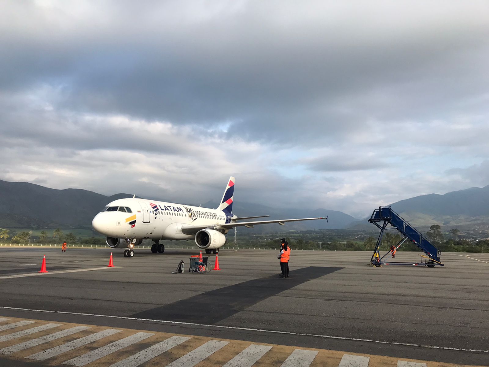
The General Directorate of Civil Aviation, through the Directorate of Air Navigation Services, began the process of implementing this procedure, a year ago, together with the air operator LATAM, to take advantage of the avionics technology that will be used by the Airbus 319 aircraft said the airline, on the Quito-Loja-Quito route.
During this process, the Air Traffic Control (ATC) personnel of the control tower of the Catamayo air terminal were trained. In addition, technical coordination was carried out regarding the type of navigation, approach and takeoff with ATC personnel from the Guayaquil Area Control Center (ACC) and ATC personnel from the Cuenca airport, who will carry out permanent control and surveillance of the flights carried out. to and from Catamayo airport.
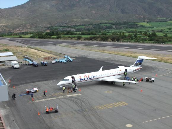

Passenger movements at Catamayo City Airport 2022: 64.685 pax, nationals
Runway
|
Runway |
|
|---|---|
|
Runway Dimensions |
1860 m x 30 m |
|
Runway Orientation |
07 / 25 |
|
Runway Surface |
50/F/D/Y/U Pavement (72000 KG) |
|
Runway Condition |
Good |
Helipad
Not established, APN is used. Pavement PCN: 50/F/D/Y/U
Airport Infrastructure Details
|
Infrastructure |
|||
|---|---|---|---|
|
Passenger / Cargo Security Screening |
Yes |
Runway Lighting |
Yes |
|
Refuelling Capacity |
Yes (Not Operational) |
Ground Handling Services |
Yes / No |
|
Air Traffic Control |
Yes |
Fire Fighting Equipment |
Yes CAT 6 |
|
Weather Information |
Yes 2 |
Aircraft Parking Space |
Yes 1 |
|
Navigation Aids |
Yes 3 |
Perimeter Fencing |
Yes / No |
|
Windsock |
Yes |
Ability to Remove Disabled Aircraft |
No 4 |
- Pavement PCN: 50/F/D/Y/U (72000 KG) The parking platform can accommodate 3 Embraer 190 type aircraft or 4 smaller aircraft
- Associated MET office CATAMAYO 593 2 2947400 ext. 1515
- The use of the RNAV instrument approach procedure at the Catamayo Airport increases the level of safety of air operations, shorten the approach time of an aircraft to the airport and thereby also reduce the emission of carbon dioxide into the air atmosphere.
- Not available, In case of these situations It is carried out through an agreement between the airport and local companies
The Loja non-directional beacon (Ident: LOJ) is located on the field. The control tower has new-technology, communications and weather forecast systems. There is a firefighting hangar, parking area for 4,000 US gallons firefighting trucks and technical maintenance block of 360 square meters facilities.
Source: DGAC, runway lighting system at Loja's "Ciudad de Catamayo" Airport.
Fuel Services Charges
Facilities/resupply capacity Catamayo Airport
fuel types: JET A-1
1 tanker
NOT operational
Royalties / Non Objection Fees (NOFs)
N/A
Ecuador - 2.2.12 Coronel Edmundo Carvajal National Airport (Macas)
Airport Overview
The Macas Airport, also known as the Coronel Edmundo Carvajal Airport, is an airport serving Macas, the capital of Morona-Santiago Province in Ecuador. The airport is located 1.9 nautical miles (3.5 km) off the approach threshold of Runway 19. The city of Macas (Morona Santiago) is the connection point for the Taisha, Gualaquiza, Limón Indanza, and Morona cantons and provides connectivity to 80 tracks in various communities in the sector; places where there is no other mode of transport than air. It is the only means of access to an average of 147 tracks of the Shuar and Achuar ethnic groups. There are 17 DGAC officials working in the terminal that allow the population to communicate with the rest of Ecuador.
The Trans Cutucú Region area is located on the border with Peru, crossing the Trans Cutucú mountain range.
The average cost of each flight to the Trans Cutucú is $250. The trip is carried out with 5 pax capacity Cessnas, Pipers, who finance the trip. Average flight time is 20-30 minutes to any point in the jungle. Air transport becomes essential for dozens of inhabitants of remote rural areas, as it is the the only means of access to an average of 147 tracks of the Shuar and Achuar ethnic groups, who do not have other communication channels.
|
Airport Location and Contact |
|
|---|---|
|
Country |
Ecuador |
|
Province or District |
Morona-Santiago |
|
Nearest Town or City |
Macas |
|
Airport’s Complete Name |
Aeródromo Nacional “Coronel Edmundo Carvajal” |
|
Latitude |
021757S |
|
Longitude |
0780715W |
|
Elevation (ft and m) |
1052 m 3451 ft |
|
IATA Code |
XMS |
|
ICAO Code |
SEMC |
|
Managing Company or Airport Authority |
Dirección General de Aviación Civil Aeródromo Nacional “Coronel Edmundo Carvajal” |
|
Management Contact Person |
Jefatura Aeropuerto Macas 593 7 2700258 |
|
NGO and/or UN Presence at Airport? |
No |
Air lines that operate with service to MACAS
MACAS is the main airport serving this area and is the departure and arrival point of flights operated by TAME Línea Aereas del Ecuador in the region, also Aero Morona, Aerokashurco, Aerosangay, Aeromacas and Amazonía Verde. There are also occasional Air Force flights.
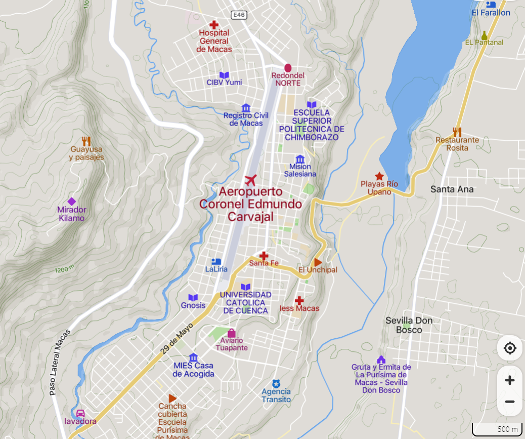
The Coronel Edmundo Carvajal Airport is located between the town of Santa Ana and Nueva Jerusalem.
Runway
The dimensions of the runway 2,560 m runway long by 30 m. wide and has all the air navigation services that make both minor and major aviation operations possible. The Hercules of the Armed Forces with capacity for 100 passengers and the Embraer 190 for commercial flights with 70 occupants are the largest aircraft that operate at the airport.
|
Runway |
|
|---|---|
|
Runway Dimensions |
2500 m x 30 m |
|
Runway Orientation |
02 / 20 |
|
Runway Surface |
Pavement, asphalt |
|
Runway Condition |
Good |
Observations:
- Turning 180° prohibited in RWY 02/20.
- It is strictly prohibited to carry out a right traffic circuit for runway 20 and a left traffic circuit for runway 02, except for overflights.

“CORONEL EDMUNDO CARVAJAL” AIRPORT MACAS by Galeria Mtop Morona Santiago
Helipad
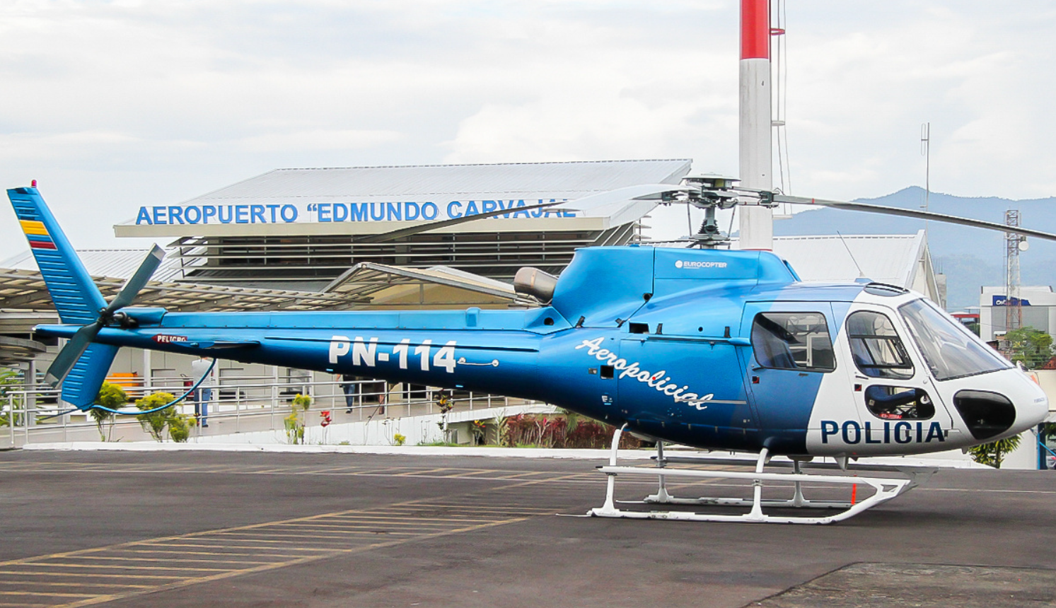
Photo: https://www.airliners.net/photo/Ecuador-Police/Eurocopter-AS-350B-3-Ecureuil/2714804/L
Not established, APN is used. There are also private helipads, resistance of platform: Unknown
Photo, Google, Alejandro Torres, Image capture Mar 2022
OPERATION IN AEROMEDICAL TRANSPORTATION
Air transport, also known as aeromedical evacuation, is the action of carrying wounded, affected, injured and/or sick people through the air (in airplanes, helicopters, small planes, among other rotary-wing or fixed-wing aircraft). These transports by air are carried out:
- When the area where the alert is registered is very difficult to access for relief personnel (on foot or in logistics vehicles) and the displacement of an aircraft from the relief entities must be activated to rescue and mobilize those affected.
- When the situation of the injured person and the degree of his injuries seriously compromise his physical integrity and it is necessary for him to be transferred urgently and as quickly as possible to a specialized health center.
In 2022 in the Amazon, ECU 911 Macas * managed the support of a private company for the air transfer of a child with health problems from the Banderas community, bordering Peru. A helicopter from the Lowell Mineral Exploration company was activated. The 10-year-old minor was taken in an ambulance from the Ministry of Public Health (MSP) to the Edmundo Carvajal airport in Macas and then to the Macas General Hospital for a more specialized evaluation.
In the same community, another transport by air was carried out of a 17-year-old Peruvian woman who was pregnant. Due to the degree of difficulty in accessing the area and the complications in the pregnancy (which put the life of the woman and her child at risk), it was essential to immediately transport the patient to a health home, where she was treated. with her baby and had no subsequent complications.
(*)ECU 911 Macas Morona Santiago, Ecuador coordinates -2.30283880234, -78.1229476929
ECU 911 call center (Quito) Phone: +593 2-380-0700
Citizens who have an emergency anywhere in Ecuadorian territory can request help through the following mechanisms: call to the single emergency line 911 and the ECU 911 smartphone application.
Airport Infrastructure Details
|
Infrastructure |
|||
|---|---|---|---|
|
Passenger / Cargo Security Screening |
Yes |
Runway Lighting |
No |
|
Refueling Capacity |
No |
Ground Handling Services |
No |
|
Air Traffic Control |
Yes 2, 6 |
Fire Fighting Equipment |
Yes CAT 5 |
|
Weather Information |
Yes 5 |
Aircraft Parking Space |
No |
|
Navigation Aids |
Yes 1, 3, 4, |
Perimeter Fencing |
Yes |
|
Windsock |
Yes |
|
|
-
Type of help MAG VAR, type of OPS supported (for VOR/ILS/ MLS, indicated decline): VOR/DME (3°W/2017) ID: MSV. NDB ID: MAS The Macas VOR-DME (Ident: MSV) is located 1.9 nautical miles (3.5 km) off the approach threshold of Runway 19. The Macas non-directional beacon (Ident: MAS) is located on the field.
-
MACAS CTR RDO 10 NM centered on VOR/DME MSV COORD 021527S 0780636W.
-
To manage the air traffic that operates in this sector, when the use of the 123.45 MHZ frequency is mentioned, the procedure called TIBA (Traffic Information Broadcast by Aircraft) will be applied, which consists of pilots disseminating relevant complementary reports and data on this frequency. to warn the pilots of other aircraft in the vicinity
-
The Aerodrome Control Service (ATZ) of the “Coronel Edmundo Carvajal” Aerodrome will provide the Aerodrome Flight Information Service (AFIS) to the extent of the reach of the 123.0 MHZ frequency in airspace classified as “Class G”.
-
MACAS associated MET office Ph: 593 2 2947400 ext. 3315
-
There is Increase in air operations, mainly minor aviation and helicopters that fly at low levels
Fuel Services Charges
Macas Airport fuel types: JET A-1
NOT operational
Royalties / Non Objection Fees (NOFs)
N/A
Ecuador - 2.2.13 Santa Rosa International Airport (Machala)
Airport Overview
Santa Rosa International Airport (also known as Coronel Artilleria Victor Larrea Airport) is an airport serving Machala, the capital of El Oro Province in Ecuador. Located 28 kilometres (12 mi) south in Santa Rosa, it replaces the closed General Manuel Serrano Airport (permanent closed) in Machala, and is designed to handle international flights from Peru.
Within its infrastructure it has a 2,470m x 45m runway, its aircraft with the highest capacity an Airbus A-320, a pre-boarding room for 252 people, radio aids, fire service and ample parking spaces. In addition, this airport not only offers a modern infrastructure, it is also part of the Incentive Plan that has discounts on landing, lighting, flight protection, flight protection en route, parking for more than 4 hours. As well as the subsidy of 40% of air fuel, implemented by the National Government.
Latam Ecuador announced it will operate Santa Rosa from Quito. Different shrimp farms and banana farms operate from Santa Rosa and have their hangars here as well as Alas del Ecuador flight school. Daily general aviation flights from Guayaquil and other parts of the coast can be seen here. Occasionally, military flights operate to and from Santa Rosa.
Aero-regional is a commercial passenger and cargo airline installed in Ecuador since 2018 with regular and non-scheduled flights, both national and international. Actually Aero-regional has two services to Lima, Perú and Caracas Venezuela based on seasonal charters
Some of the main services of the airport are a medical service and fast-tracked security clearance. In case of any emergency the fire station and ambulances have a prompt response.
|
Airport Location and Contact |
|
|---|---|
|
Country |
Ecuador |
|
Province or District |
El Oro |
|
Nearest Town or City |
Machala (28 km) Santa Rosa (4.8 km) |
|
Airport’s Complete Name |
Santa Rosa International Airport |
|
Latitude |
032611S |
|
Longitude |
0795902W |
|
Elevation (ft and m) |
21 ft / 6.4 m |
|
IATA Code |
ETR |
|
ICAO Code |
SERO |
|
Managing Company or Airport Authority |
Dirección General de Aviación Civil Aeródromo Nacional “Santa Rosa” |
|
Management Contact Person |
Jefatura Aeropuerto Santa Rosa Ph: (593) 7 3903460 |
|
NGO and/or UN Presence at Airport? |
No |
Passenger movements at Santa Rosa Airport in 2022: 12.591 pax
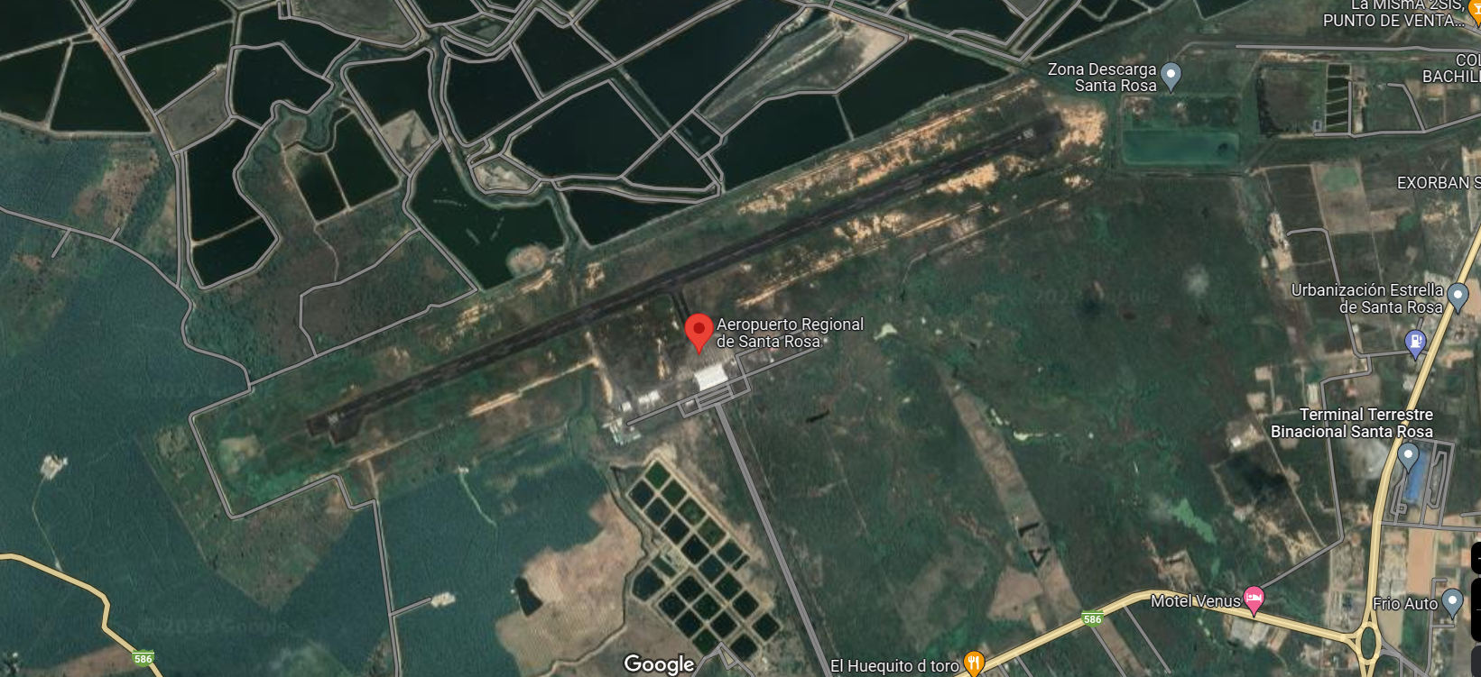
Runways
 Source: El Universo, https://www.eluniverso.com/
This airport was built next to the Santa Rosa Agro airfield which is a private airstrip used for crop dusting. Though it is not part of the same airport, the Santa Rosa Agro runway appears in the airport charts. However, both airfields are separate and there is no physical connection between both. Santa Rosa tower must be contacted for take-off and landing clearance.
|
Runway #1 |
|
|---|---|
|
Runway Dimensions |
2500 m x 30 m |
|
Runway Orientation |
07 / 25 |
|
Runway Surface |
60/F/D/Y/U Pavement |
|
Runway Condition |
Good |
- Aircraft operating on runway 07/25 of the “Santa Rosa” Regional Airport will have priority over those operating on runway 09/27; ATC will authorize the agricultural aircraft to carry out a visual hold away from the approach path or on the ground as the case may be.
- Operations at the Santa Rosa Regional Airport runways 07/25 and 09/27 will NOT be carried out simultaneously; will be considered one operation at a time. Agricultural aircraft will avoid flying over the runway 07/25
|
Runway #2 |
|
|---|---|
|
Runway Dimensions |
914 m x 18 m |
|
Runway Orientation |
09 / 27 |
|
Runway Surface |
6800 kg 15000 pounds Pavement, flexible |
|
Runway Condition |
Good |
- The operation on runway 09/27 will be exclusively for agricultural aircraft, which will be subject to authorizations from the Air Traffic Services.
- Due to the lack of visibility towards runway 09/27 from the Control Tower, ATC WILL NOT USE the phraseology “AUTHORIZED TO TAKE OFF” or “AUTHORIZED TO LAND”, limiting itself to reporting local weather conditions, essential traffic and other instructions. ATC that correspond.
- Aircraft operating on runway 07/25 of the “Santa Rosa” Regional Airport will have priority over those operating on runway 09/27; ATC will authorize the agricultural aircraft to carry out a visual hold away from the approach path or on the ground as the case may be.
- Because runway 09/27 is located within the “Santa Rosa” Regional Airport, VFR operations on this runway cannot be carried out if the weather conditions are below the minimum meteorological conditions for VFR flights.
Airport Infrastructure Details
|
Infrastructure |
|||
|---|---|---|---|
|
Passenger / Cargo Security Screening |
Yes |
Runway Lighting |
Yes 2 |
|
Refueling Capacity |
No |
Ground Handling Services |
No |
|
Air Traffic Control |
Yes |
Fire Fighting Equipment |
Yes CAT 5 |
|
Weather Information |
Yes 1 |
Aircraft Parking Space |
Yes 4 |
|
Navigation Aids |
Yes 3 |
Perimeter Fencing |
Yes |
|
Windsock |
Yes |
|
|
- Associated MET Office: SANTA ROSA 593 2 2947400 Ext. 2435
- Approach and landing lights: PAPI Left / 3rd (6M/19FT)
- Type of help MAG VAR, type of OPS supported (for VOR/ILS/ MLS, indicated decline): VOR/DME (2°W/2020) ID:SRVLOC 07 (2°W/2020) ILS CAT I (2°W o 358°) ID: ISR. GP 07 DME
- Surface and resistance of the platform: Surface: Pavement Resistance: PCN: 70/R/D/Y/U
Helipad
Not established, APN is used. Pavement PCN: 70/R/D/Y/U
Fuel Services Charges
Santa Rosa Airport
fuel types: JET A-1
NOT operational
Royalties / Non Objection Fees (NOFs)
N/A
Ecuador - 2.3 Road Network

Ecuador has a total of 43,200 km of roads. The State Road Network (Red Vial Estatal) is made up of primary and secondary roads. The set of primary and secondary roads are the main roads that register the highest vehicular traffic, interconnects the provincial capitals, canton capitals, international border ports with or without customs and large and medium centers of economic activity. The total length of the State Road Network (including primary and secondary roads) is approximately 10,300 km of road.
|
Ecuador Road Inventory (kms) |
|||||
|---|---|---|---|---|---|
|
|
Coast |
Highlands |
Amazon |
Islands |
Total |
|
Paved |
4,040 |
3,628 |
478 |
15 |
8,161 |
|
Gravel |
6,665 |
12,405 |
3,816 |
169 |
23,055 |
|
Dirt |
5,787 |
6,020 |
177 |
0 |
11,984 |
|
Total |
16,492 |
22,053 |
4,471 |
184 |
43,200 |
Distance Matrix
|
Distances from Capital City to Major Towns (km) |
|||||||||||
|
|
Quito |
Ambato |
Cuenca |
Guayaquil |
Manta |
Tulcán |
Esmeraldas |
||||
|---|---|---|---|---|---|---|---|---|---|---|---|
|
Quito |
|
111 |
432 |
390 |
362 |
239 |
300 |
||||
|
Ambato |
111 |
|
321 |
277 |
358 |
381 |
371 |
||||
|
Cuenca |
432 |
321 |
|
191 |
392 |
702 |
654 |
||||
|
Guayaquil |
390 |
277 |
191 |
|
180 |
659 |
447 |
||||
|
Loja |
640 |
529 |
207 |
398 |
597 |
909 |
861 |
||||
|
Manta |
362 |
358 |
392 |
180 |
|
631 |
371 |
||||
|
Tulcán |
239 |
381 |
702 |
659 |
631 |
|
395 |
||||
|
Esmeraldas |
300 |
371 |
654 |
502 |
371 |
395 |
|
||||
|
Travel Time from Capital City to Major Towns |
|||||||||||
|
|
Quito |
Ambato |
Cuenca |
Guayaquil |
Manta |
Tulcán |
Esmeraldas |
||||
|
Quito |
|
02h23 |
07h41 |
07h22 |
06h44 |
04h24 |
05h14 |
||||
|
Ambato |
02h23 |
|
04h13 |
05h08 |
04h57 |
04h50 |
05h07 |
||||
|
Cuenca |
07h41 |
04h13 |
|
03h28 |
5h19 |
11h22 |
08h22 |
||||
|
Guayaquil |
07h22 |
05h08 |
03h28 |
|
03h17 |
07h55 |
07h28 |
||||
|
Loja |
10h58 |
07h40 |
03h30 |
05h41 |
08h14 |
11h11 |
12h11 |
||||
|
Manta |
06h44 |
04h57 |
5h19 |
03h17 |
|
08h22 |
05h21 |
||||
|
Tulcán |
04h24 |
07h55 |
11h22 |
07h55 |
08h22 |
|
05h43 |
||||
|
Esmeraldas |
05h14 |
05h07 |
08h22 |
07h28 |
05h21 |
05h43 |
|
||||
Road Security
Although some of Ecuador’s roads and highways have greatly improved in recent years, road travel throughout Ecuador can still be dangerous, especially at night. Rural roads are often unpaved, generally in poor condition or affected by heavy rains and mudslides. Mountain roads may lack safety features such as crash barriers or guard rails, and conditions are frequently made more treacherous by heavy fog. Highways are often unmarked and unlit, and do not have signs indicating destinations. In addition, slow-moving buses and trucks frequently stop in the middle of the road unexpectedly. In the countryside, livestock is often herded along roads or grazes on roadsides. Lacking sidewalks, many roads are also used by pedestrians. Driving in Ecuador can be a confusing experience for foreigners used to drive in Europe or the United States. In provincial areas, traffic laws are rarely enforced, and drivers tend to ignore posted signs and lights. However, the road systems in major cities are usually orderly and well planned, although fraught with traffic congestion.
Weighbridges and Axle Load Limits
There are currently no operational weighbridges in Ecuador.
|
Axle Load Limits |
Ecuador |
Colombia |
Perú |
|---|---|---|---|
|
Truck with 2 Axles |
18 MT |
18 MT |
18 MT |
|
Truck with 3 Axles |
27 MT |
27 MT |
27 MT |
|
Truck with 4 Axles |
32 MT |
32 MT |
32 MT |
|
Semi-trailer with 3 Axles |
27 MT |
27 MT |
27 MT |
|
Semi-trailer with 4 Axles |
31 MT |
31 MT |
31 MT |
|
Semi-trailer with 5 Axles |
47 MT |
47 MT |
47 MT |
|
Semi-trailer with 6 Axles |
48 MT |
48 MT |
48 MT |
|
Truck & Drawbar Trailer with 4 Axles |
N/A |
N/A |
N/A |
|
Truck & Drawbar Trailer with 5 Axles |
N/A |
N/A |
N/A |
|
Truck & Drawbar Trailer with 6 Axles |
N/A |
N/A |
N/A |
|
Truck & Drawbar Trailer with 7 Axles |
N/A |
N/A |
N/A |
Road Class and Surface Conditions
|
Ecuador – Road Classification |
|
|
Classification |
Road Description |
|---|---|
|
Class A |
Primary Roads: International trunk roads linking international boundaries, international ports or provincial capitals |
|
Class B |
Secondary Roads: Recollection of traffic from rural or urban area and linking it to the Primary Roads |
|
Class C |
Tertiary Roads and local tracks: They connect Parishes and production areas to the National Road Network |

Source: Arqº María de los Angeles Duarte, Ministerio de transportes y Obras Públicas
An important route, the Pan-American highway, crosses the country from North to South from Tulcán (in the border with Colombia) to Macará (in the border with Peru), completing a route of 1,397 kilometers throughout the Andean mountains; it is the main artery of communication in the country, as well as with the neighboring countries. Since 2008, GoE directed its effort on road maintenance. In addition to this action, the administration and maintenance of the main roads are currently concessioned to private companies, resulting in a very good condition of primary roads throughout the country.
North-South route Bogotá - Quito - Lima
The Ecuadorian section is asphalted and has sections on rigid pavement, having the character of a toll highway in some sections, having from two lanes in each direction, with the usual sections having three lanes in each direction from the border with Colombia to Otavalo, and up to five at the entrance to the Metropolitan District of Quito from the north; Between the Quito and Riobamba routes there are three lanes in each direction, as well as from the border between the Cañar and Azuay provinces to the south of Cuenca, between the Azogues and Cuenca routes.
The Pan-American Highway is not a single great work or megaproject in the style of the Trans-Siberian railway, but a multitude of roads from different countries and characteristics connected to each other. However, almost a century after its conception, it is almost complete, and extends from the state of Alaska (United States) in North America to the city of Quellon, Chiloe (Chile) in South America, passing through the cities of Mexico City. (Mexico), Guatemala City (Guatemala), San Salvador (El Salvador), Cali (Colombia), Quito (Ecuador), Lima (Peru) and Los Andes (Chile) originally.
Ecuador - 2.3.1 Land Border Crossing of Rumichaca (Colombia)
Overview
There are several official border crossings between Ecuador and its neighbors Peru and Colombia. The main ones are Rumichaca Tulcán-Ipiales International Bridge, San Miguel International Bridge, Huaquillas and Macará.
The Puente Internacional de Rumichaca is the main border crossing between Ecuador and Colombia; It was originally the obligatory ancestral step, from the time of the conquest to the present day. Above the natural bridge rise the customs houses of Ecuador and Colombia, built around 1936 and 1932 respectively.
Development plans for the Ecuador-Colombia Border Zone
As a result of the regular and extraordinary activity in recent years, which is recorded at the historic Tulcán-Ipiales border crossing, there are binational development agreements stipulated in:
PBIFEC: Ecuador-Colombia Binational Border Integration Plan. PBIFEC. The Binational Border Integration Plan Ecuador Colombia –PBIFEC is the effort to establish a common plan that articulates the national plans of both countries for the good of the border areas. Identifying what their social conditions are and how to improve them. Generating productive activities and sources of work.
ZIF: Border Integration Zone. "Border Integration Zone" (ZIF) the adjacent border territorial areas of Member Countries of the Andean Community for which policies will be adopted and plans, programs and projects will be implemented to promote sustainable development and integration
ZIFEC: Ecuador-Colombia Border Integration Zone (ZIF-Ecuador: includes the provinces of Carchi, Esmeraldas, Imbabura and Sucumbíos; ZIF-Colombia: includes the Departments of Nariño and Putumayo).
Esmeraldas Treaty: It is the one granted by the competent national authority, which states that the transporter and the vehicle are authorized to carry out cross-border transportation of cargo.
MERCOSUR Ecuador is a state belonging to MERCOSUR and in terms of Border Integration it applies the benefits stipulated in the Mercosur Border Integration agreement.
To enter and leave Colombia to Ecuador and vice versa, it is the obligation of citizens, without exception, to present themselves at the corresponding immigration control posts at the CENAF (on the Rumichaca bridge) and provide the required documentation to the migration authorities to carry out the controls and authorizations of the case as determined by law.
Travelers must present a valid passport for stamping and proof of financial independence which may be in the form of return airfare, cash ($20 daily minimum), traveler's checks and/or credit card to access Peru and Colombia from Ecuador.
The authorities will only accept original identification documents. Very few nationalities require consular visas to enter Peru or Colombia from Ecuador, but it is recommended to consult first with diplomatic offices or specialized agencies.
Cargo movement
In 2022, the largest volume of cargo moved by Ecuador's border customs with its neighbouring countries, Tulcán was registered by customs with a cargo movement of 1,080 thousand tons, 12.5% higher compared to the cargo moved during the former year.
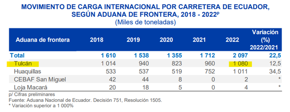
According to percentage structure, in 2022, the largest cargo movement recorded by the border customs was through the Tulcán customs and represented 51.5% of the movement of merchandise that crosses Ecuador borders.
Control to the Transportation of International Cargo and Free Border Transit
For light and heavy cargo vehicles, tank trucks, tankers and similar those circulate between borders, they must carry the corresponding authorizations established by Ecuadorian regulations, especially the referral guide indicating the country of origin and destination, which will constitute “laissez-passer”. sufficient for circulation within the country.
The toll is free on the Ecuadorian side.
Irregular Migration
The northern border that borders Colombia is porous. It is 586 km long; It extends between the mouth of the Mataje River, in the Ancón de Sardinas Bay (Esmeraldas), to the mouth of the Güepí River, in the Putumayo River (Sucumbíos).
Through the E-35 (Panamericana Norte), between 100 and 200 Venezuelan citizens enter daily from Ipiales to Tulcán, trying to reach Peru and Chile. Ecuador has become the obligatory corridor for the commission of immigration crimes.
Likewise, the Venezuelan exodus continues and it is also confirmed not only that they enter from north to south, but also that they return to their country of origin. In addition, the irregular border crossings called trochas are still active, they are ideal routes to circumvent immigration controls carried out by the state in Rumichaca.
It is estimated that irregular border crossings amount to more than one hundred crossing points.
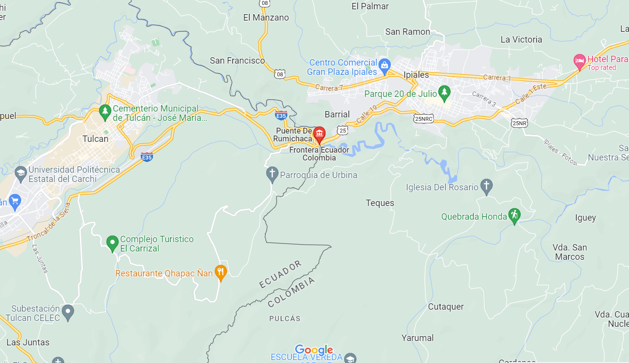
|
Border Crossing Location and Contact |
|
|---|---|
|
Name of Border Crossing |
Puente Internacional Rumichaca
Ecuador: Tulcán
Colombia: Ipiales |
|
Province or District |
Provincia de Carchi |
|
Nearest Town or City with Distance from Border Crossing |
Quito (240 km) |
|
Latitude |
0.8153° |
|
Longitude |
-77.6649° |
|
Managing Authority / Agency |
Centro Nacional Fronterizo (CENAF),CENAF Rumichaca |
|
Contact Person |
Centro Nacional de Atención Fronteriza Rumichaca - (Puente Internacional Rumichaca, Panamericana Norte Km. 0). Tel: (062) 245-251 |
|
Travel Times |
|
|---|---|
|
Nearest International Airport |
Quito, 240 km Truck Travel Time: 6 hrs Car Travel time: 4:30 hrs |
|
Nearest Port |
Esmeraldas (375 km) Truck Travel Time: 8 hrs Car Travel time: 06:15 hrs |
|
Nearest location with functioning wholesale markets, or with significant manufacturing or production capacity |
Quito, 240 km Truck Travel Time: 6 hrs Car Travel time: 4:30 hrs |
|
Other Information
|
Carr. Panamericana / Troncal de la Sierra / E35 |
|
Hours of Operation |
|
|---|---|
|
Mondays |
06h00 a 14h00 14h00 a 22h00 22h00 a 06h00 |
|
Tuesdays |
06h00 a 14h00 14h00 a 22h00 22h00 a 06h00 |
|
Wednesdays |
06h00 a 14h00 14h00 a 22h00 22h00 a 06h00 |
|
Thursdays |
06h00 a 14h00 14h00 a 22h00 22h00 a 06h00 |
|
Fridays |
06h00 a 14h00 14h00 a 22h00 22h00 a 06h00 |
|
Saturdays |
06h00 a 14h00 14h00 a 22h00 22h00 a 06h00 |
|
Sundays |
06h00 a 14h00 14h00 a 22h00 22h00 a 06h00 |
|
National Holidays
|
N/A |
|
Seasonal Constraints |
No |
Daily Capacity
The Rumichaca Bridge has a total average daily traffic of 12,629 vehicles, with a distribution of 52% (6,513 vehicles) in the Colombia-Ecuador direction and 48% (6,117 vehicles) in the Ecuador-Colombia direction. Regarding the vehicle composition on the Rumichaca Bridge, total capacity (3-day period counting), the result is that 88% are cars, 3% buses and 9% trucks.
All procedures before the immigration authorities of Colombia and Ecuador are in person, free and generally fast, so they do not require intermediaries.
In Quito, Guayaquil, Rumichaca, Huaquillas and San Miguel, 406 professionals trained in documentary control Migration Law and immigration documents, treaties and international agreements; In addition to serving the public, they serve thousands of users who enter and leave Ecuadorian territory daily. At the Centro Nacional de Atención en Frontera (CENAF) in Rumichaca, 40% of its officials speak English and 10% another language.
To cross the border between Ipiales (Colombia) and Ecuador, which is divided by a river in the Rumichaca area, you need a valid passport. The procedure has no cost and you have to be patient, depending on the volume of pedestrians and vehicles. Waiting times could eventually be long.
Customs Clearance
Resolution No. SENAE-DGN-2013-0361-RE regulates customs activities that take place on the land borders of the Ecuadorian customs territory. Foreign trade activities between the border between Ecuador and Colombia have historically been characterized by problems of smuggling, illegal trafficking of goods that the government and the customs surveillance unit try to stop.
Although the border customs control procedure is the same as in a port or airport, the time is longer due to the dangers posed by smuggling and drug trafficking at the borders.
If the goods do not require control documents for their dispatch, the border importer may declare their goods taxed in Chapter 98, in the specific subheading that corresponds to taxed passenger goods. On the contrary, if the imported merchandise requires control documents, it will be declared in the specific subheading between chapters 1 to 97. *
(*) https://www.aduana.gob.ec/wp-content/uploads/2021/04/RCopci.pdf
Vehicle Entry
Passenger vehicle (local transport or taxis): present Unique Passenger Transport Documentation.
Tourist Transport Vehicle: present the Single Tourist Transport Document and the list of the tourist group.
Vehicle in Community Customs Transit: Present a copy of the service provision permit and Certificate of Suitability, granted by the National Commission for Land Transport, Traffic and Road Safety.
Private or rented vehicles for tourist purposes: You must present to the corresponding Ecuadorian Customs officials the enabling documents for this purpose: identity document (passport) duly stamped by immigration, driver's license and vehicle registration, through which the entering vehicle constitutes a special and preferential pledge in favor of the Customs of Ecuador. The permanence of the vehicle for private use by tourists will be equal to the maximum time granted to the tourist, according to immigration registration.
Goods Entry
Any traveler who enters through the country's land borders goods subject to payment of taxes, whose value is less than or equal to USD $2,000.00 (or its equivalent in another currency); You must present the Simplified Customs Declaration (DAS), and attach the documents requested by Customs. If the value of the merchandise subject to payment of taxes exceeds USD $2,000.00 (or its equivalent in another currency); You must register as an Importer, hire the services of a Customs Agent authorized by Ecuadorian Customs, obtain import permits and licenses, depending on the product, and present the Customs Import Declaration (DAI). For more information on HOW TO IMPORT, see https://www.aduana.gob.ec/para-importar/ Regardless of the type of merchandise being imported, Ecuadorian Customs may require:
- Private or rented vehicles for tourist purposes
- Certificates of Origin from the countries with which Ecuador maintains trade agreements (to benefit from the corresponding tax exemption)
- Prior Control Documents required by COMEXI regulations.
References:
https://www.aduana.gob.ec/files/pro/leg/tra/2016/jun/k_MejoraPasosFronteraSENPLADES.pdf
https://www.aduana.gob.ec/files/pro/leg/res/2013/SENAE-DGN-2013-0361-RE.pdf
https://www.aduana.gob.ec/wp-content/uploads/2021/04/RCopci.pdf
Colombians who enter Ecuador with a private vehicle must obtain an entry permit from the Customs of this country, bring: driving license, property card, identification document, DJT form (Sworn Tourist Declaration, download on the page www.aduana.gob.ec; if the vehicle is in the name of another person, carry authorization authenticated by power of attorney, deliver the above to the National Customs Service (Senae), or Customs in Rumichaca, these procedures are free. With international transport vehicles of passengers or public service, the same documents mentioned above, add an insurance contract in which a civil liability policy is expressed, and a list of passengers.
For Ecuadorians with a car, who visit the city of Ipiales, Colombia, and its surroundings, the traffic and police authorities will not require Mandatory Traffic Accident Insurance SOAT, this to facilitate tourism and border commerce; This requirement is mandatory starting at km 21 via Panamericana towards Pasto, Nariño, or traveling beyond this site; They must acquire it at the Rumichaca bridge, customs house. Failure to possess the SOAT is subject to onerous fines.
For those who do not have their own transportation, they should keep in mind that the public taxi service from Tulcán to the Rumichaca bridge is available until 5:30 p.m. m.; From this time onwards you have to pay express taxi. From the bridge to Ipiales, there are public vehicles until 7 at night; They return to work at 6 a.m. m. of the next day. The distance from Tulcán to Rumichaca is 10 km, two hours on foot. And from this place to Ipiales, it is 3 km, walking 40 minutes without suitcases.
Currency Exchange
The Rumichaca international bridge is open 24 hours a day and money exchange (pesos to dollars or vice versa) can be done at this place. During business (working) hours there is currency exchange in the two border cities.
Customs Director Rumichaca: Christian Iván Villarreal Chuca
Address: Av. 24 de Mayo y Alfonso Mena .Sector El Capulí
Postal code: 040101
Ph: (593-6) 2980-391
Open from-to: 08h00 – 17h00
For more information about customs in Ecuador, please consult: : https://www.aduana.gob.ec/ and 1.3 Customs Information.
Other Relevant Information
Public entities that operate in Centros de Atención en Frontera:
• National Police: Provide support in border control of people and vehicles, additionally control the access doors to the Centers directly to people.
• National Customs Service: Carry out control of customs processes and redirect people with symptoms to the MSP.
• Agrocalidad: Fumigation and exterior disinfection of all vehicles entering the centers; control and compliance with phytosanitary processes.
• Armed Forces: In coordination with the National Police, control the entry of users to the Border Attention Centers.
• Ecuadorian Traffic Commission: Review of the qualifications to carry out international transportation, additionally registering vehicles entering and leaving the country.
• Ministry of Transportation and Public Works: Carry out weight and dimension control of cargo vehicles. The MTOP is in charge of the administration of the Border Attention Center, they have an official audience for this activity.
• Migration: Registration and immigration control of users entering and leaving the country, additional users are registered to issue the Andean Card.
Ecuador - 2.3.2 Land Border Crossing of Huaquillas - Tumbes (Peru)
Overview
The border crossing through Huaquillas-Tumbes is the most popular and fastest of the three passes between Ecuador and Peru. In recent years, the two countries have improved border crossing services in such a way that the exit from one country and entry to the other take place in the same building. With modern facilities, the migration building to go from Ecuador to Peru is located on the Peruvian side and the migration building from Peru to Ecuador is located on the Ecuadorian side. In summary, in a single building there are the two rows to carry out migration.
Very few nationalities are required consular visas to enter Peru or Colombia from Ecuador but it is suggested to check with diplomatic offices or specialized agencies before leaving your country of origin.
The militarization of the border was announced on January 26 2020, following the news of the arrest in Tumbes of nearly 500 migrants, mostly Venezuelans, the operation was carried out jointly Ecuador and Perú and whose objective is to "block the entry of illegal migrants" in the midst of the health emergency.
Binational Border Assistance Center, Huaquillas (CEBAF)
The CEBAF complex is part of the need to facilitate international road transport in the Andean sub region. Likewise, it is made up of two twin buildings, one in each country, destined to facilitate customs, migration, anti-narcotics and agro-quality services. Around 112 officials work in these facilities, the same ones who are in charge of the processes of controlling the departure and arrival of people both in Ecuador and Peru, the working hours are 24 hours 7 days a week. Approximately 27,000 people and 1,500 vehicles pass through CEBAF per month, a figure that increases during holidays. Within the complex, there are other complementary constructions necessary for the development of activities, such as control of weights and measures, control of transport vehicles, kennels for anti-drug dogs, laboratories, food court, etc. This center makes it possible to implement an efficient and integrated system for the management and control of binational traffic, avoiding duplication of procedures and registrations on leaving and entering each country.
|
Border Crossing Location and Contact |
|
|---|---|
|
Name of Border Crossing
|
Paso fronterizo Huaquillas-Tumbes Ecuador: Huaquillas Perú: Aguas Verdes |
|
Province or District |
El Oro |
|
Nearest Town or City with Distance from Border Crossing |
Huaquillas (0 km) |
|
Latitude |
-3.480278 |
|
Longitude |
-80.231667 |
|
Managing Authority / Agency |
Binational Border Assistance Center (CEBAF) Huaquillas |
|
Contact Person |
Director Manuel Defas Auhing Eje vial Nro. 1 Puente Internacional de la Paz, CEBAF cabecera Ecuador (593-7) 2-609-002 |
| Travel Times | |
|---|---|
| Nearest International Airport |
Guayaquil International Airport (240 km) Truck Travel Time:5:30 hrs Car Travel time: 4:20 hrs |
| Nearest Port |
Port of Machala “Puerto Bolívar” (71 km) Truck Travel Time: 1:20 hrs Car Travel time: 55 minutes |
| Nearest location with functioning wholesale markets, or with significant manufacturing or production capacity |
Machala (71 km) Truck Travel Time: 1:20 hrs Car Travel time: 55 minutes |
| Other information |
The Machala port “Puerto Bolívar” with very good berthing facilities is strategically located where the most famous banana farms in the world are located, with an annual production of three million tons. Furthermore, the shrimp industry is also quite active in the region. In addition to refrigerated cargo, the terminal also handles dry cargo such as paper / paper clay and concentrated copper. The route Huaquillas-Machala has mechanical and fuel services Other than trucks and semi trailers, multiple bus operators provide regular day and night service to this route and towns in between. i.e.: -Cooperativa de Transporte CIFA -Transportes Occidentales -BAÑOS Cooperativa De Transportes y Turismo -Trans Esmeraldas S.A. -Cooperativa de Transportes Patria |

|
Hours of Operation |
|
|---|---|
|
Mondays |
24 hours |
|
Tuesdays |
24 hours |
|
Wednesdays |
24 hours |
|
Thursdays |
24 hours |
|
Fridays |
24 hours |
|
Saturdays |
24 hours |
|
Sundays |
24 hours |
|
National Holidays |
N/A |
|
Seasonal Constraints |
None |
Daily Capacity
Through the Huaquillas border customs, in 2019 the cargo vehicles mobilized to Peru totaled an output of 87,358 tons or cargo * Aproximately. 7,300 tons per month, which makes, estimated 243 tons per day. These figures give a concrete idea of the volumes in transit through this border.
Note: The figures have as source of information the International Cargo Manifests (MCI) and the Freight manifest (CPIC). “Carta Porte Internacional por Carreteras”
(*)Source: National Customs Service of Ecuador.
Customs Clearance
Resolution No. SENAE-DGN-2013-0361-RE regulates customs activities that take place at the land borders of the Ecuadorian customs territory. Although the border customs control procedure is the same as in a port or airport, there is a longer time due to the dangers posed by smuggling and drug trafficking at the borders. If the merchandise does not require control documents for dispatch, the border importer may declare its taxable merchandise in chapter 98, in the specific subheading that corresponds to taxable goods of travelers. On the contrary, if the imported merchandise requires control documents, it will be declared in the specific subheading between chapters 1 to 97. *
(*)https://www.aduana.gob.ec/wp-content/uploads/2021/04/RCopci.pdf
If the taxable goods exceed $ 2,000, the cargo will be moved to a temporary warehouse while the Customs Import Declaration is being made. Travelers are recommended to declare their taxable assets honestly and avoid penalties for customs offenses or crimes derived from smuggling. It is recommended that the National Customs Service of Ecuador strengthen the presence of officials from the customs surveillance unit to deal with the inconvenience of smuggling.
The Organic Code of Production, Trade and Investments (COPCI) it is the established code with purpose of regulating the production process in the stages of production, distribution, exchange, trade, consumption, management of externalities and productive investments. RCOPCI is the regulation to the Title of the Customs Facilitation for Trade, of book V of the Organic Code of Production, Trade and Investments, has the objective of specifying the regulation of book V of COPCI.
Source: https://www.aduana.gob.ec/files/pro/leg/tra/2016/jun/k_MejoraPasosFronteraSENPLADES.pdf
https://www.aduana.gob.ec/files/pro/leg/res/2013/SENAE-DGN-2013-0361-RE.pdf
https://www.aduana.gob.ec/wp-content/uploads/2021/04/RCopci.pdf
For more information on customs in Ecuador, please see the following links: //www.aduana.gob.ec/ and 1.3 Customs Information.
Other Relevant Information
Public entities that operate in the Centers of Attention at the border:
| Agency | Description |
|---|---|
| Ministry of Public Health | Carry out the screening and control of all citizens of Ecuadorian nationality, foreigners residing in Ecuador and drivers of cargo vehicles. |
| National Police | Provide support in border control of people and vehicles, additionally to control the access doors to the Centers direct to people. |
| National Customs Service | Carry out the control of customs processes and redirection of people with symptoms to the MSP. |
| Agrocalidad | Fumigation and exterior disinfection of all vehicles that they enter the centers; control and compliance with phytosanitary processes. |
| Armed Forces | In coordination with the National Police, carry out the control of user entry to Border Service Centers. |
| Transit Commission of Ecuador | Review of the qualifying titles for carry out international transport, additionally register incoming vehicles and leaving the country. |
| Ministry of Transport and Public Works | Carry out the control of weights and dimensions to cargo vehicles. The MTOP is in charge of administration of the Border Service Center. |
| Migration | Registration and migration control for users entering and leaving the country, additional users are registering to issue the Andean Card. |
For more information on government contact details, please see the following link: 4.1 Government Contact List.
Ecuador - 2.4 Railway Assessment

Railways are limited in scope and are mainly used for tourist purposes. There are 965 km (600 mi) long railways in the country (all of them narrow gauge). In 2020, the Ecuadorian government announced plans to liquidate Ferrocarriles del Ecuador. The decision is aimed at substantially reducing expenses at a time when government revenues, especially from oil, have been severely reduced. The assets of the company Ferrocarriles del Ecuador, which is in the process of liquidation, will be transferred to the Ministry of Transportation and Public Works (MTOP). The liquidation is due to the fact that the public company was not profitable, since between 2012 and September 2020 recorded losses of USD 144 million, especially in tourism promotion. The MTOP assumes the administration of the railways, trains, locomotives, wagons and intangibles such as brands, intellectual property rights, registrations, patents, rolling stock, equipment and machinery, tools, useful spare parts, stocks, appliances, among others, maintained. by the Ferrocarriles del Ecuador company.
According to records prior to the announcement of the definitive closure, the public company had 10 electrodiesel locomotives; 7 steam locomotives; 7 autoferros; 36 modern, air-conditioned and wooden carriages; 3 vans, 4 workshops and 459 kilometers of tracks.
Project Relaunch Efforts.
The State, through its ministry and competent agencies, continues to make efforts to relaunch the Ecuadorian Railway Network, observing current feasibility laws and the real opportunities of the project would be three services: Social Train, Tourism Train and Freight Train, each one with its challenges and opportunities.
The great challenge involved in estimating costs in the context of Ecuador is given by the strong geographical differences that the country presents, in particular, the fact that a large part of its territory is mountainous. The economic profitability of the railway is due to the abundant amount of cargo, non-perishable and long distance. The geographical characteristics in the mountains, mainly with so many inter-Andean curves, do not allow more wagons to be hooked up and the main objective of the project is distorted. In the mineral concentrate loading sector, there is also strong competition since the activity is already served by a fleet of specially dedicated trucks and interference of this type would create unemployment.
Long-distance passenger traffic discontinued 30 years ago is not feasible in the face of road competition.
Condition of the Ecuadorian Railway Network as of 2021
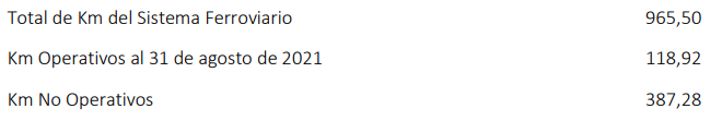
The total extension of the country's railway network currently reaches 956.50 kilometres. About the basis of the track inspection tours carried out by the company in liquidation, and separating the 459.40 kilometres “out of service or abandoned”, it is concluded that there are currently 118.92 operational kilometres (requiring primary maintenance), and 387.28 non-operational kilometres (requiring major intervention), totalling 506.2 km. Besides, 81 assets and 95 stations, of which only 35 are enabled.
The aforementioned 459.4 kilometres that are out of service are those that at the time were not taken into account within the so-called Project of Rehabilitation of the Railway System of the years 2010 and 2013 or that for a long time were abandoned: they are those affected by the winter season that has caused collapses and undermining of the platform mainly in areas where the road is developed
next to the river. These sectors are also affected by excess weeds and the theft of track elements.
railway such as rails and fastenings. Passing Bucay (before Sibambe), in Milagro asphalt has been placed over the intersections. Reactivation is expected but it is difficult to completely recover the railway.
Ref: Subsecretaría de Transporte y Ferroviario, 2021.
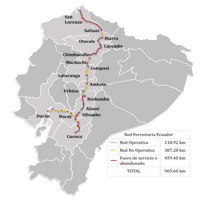
Ecuador - 2.5 Waterways Assessment

Overview
In general, there are no waterways of consistent size or volume to allow for any noticeable inland waterway navigation. Nonetheless, there is a connection leading all the way to Brazil, that allows navigation with barges that transport mainly oil industry and mining equipment.
The Manta Manaus Multimodal Corridor Project
The Manta-Manaus route is a multimodal corridor that combines maritime, air, land and river transport and whose projection is to link the Pacific and Atlantic oceans through Ecuador and Brazil. It is part of the project portfolio of the Initiative for the Integration of Regional Infrastructure South American. This corridor is has become an emblematic project of the Ecuadorian State, mainly in charge of the Ministry Production, Employment and Competitiveness (MCPEC). The Manta-Manaus land route is approximately 578 km, while the waterway has been calculated at 861 km, from which 240 km cross the territory Ecuadorian along the Napo River.

In 2010, a funded study was conducted by the Inter-American Development Bank (BID) on the navigability of the Napo River in the Ecuadorian and Peruvian sections. The study part of which, to achieve the highest profitability of the logistics corridor, the river must be navigable at least 95% of the year, considering the four-feet draft barges fleet. In Ecuador a large number of baddies were identified steps and critical points since in this section the water level and the number of sand banks are often problematic for Brazilian vessels, with greater draft than the local ships.
To be able to navigate the Napo River in the Ecuadorian section, the consultants conclude that it would be necessary to dredge deeper than in the Peruvian section with dredging machinery operating for at least 6 months a year. It was verified that even considering the traffic of individual barges, if you wanted to respect the draft of 4 feet and with the margins or drafts of recommended safety, they should be dredged more of 60 km of river, that is practically 25 times more in length than in the Peruvian section and with much greater depths of cut given the low depths of the river in low water.
According to this consultancy, the dredging of the section Ecuadorian would be a very expensive operation and technically very complex. It would be necessary to interrupt the navigation in multiple points given the lack alternative channels, it would be environmentally very shocking (due to the enormous volumes that should be mobilized, surely greater than 15 million cubic meters per year) and therefore it would also be economically unsustainable, whatever the traffic of merchandise to be mobilized within the predictable margins.
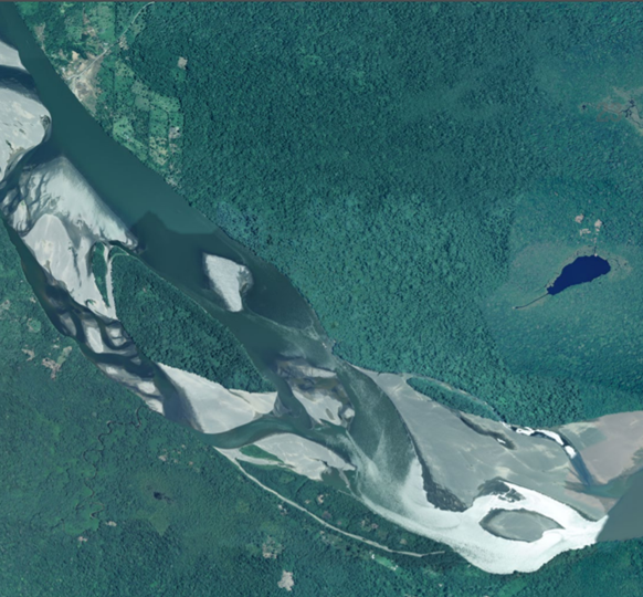
Aerial view, section of the Napo River in the low Amazon Rain Forest basin
The Napo River begins at the foot of the volcano Cotopaxi, and the páramo of the National Park Llanganates, and is one of the tributaries of the Amazon river. With its length of 1,130 km, the first 463 km are within the Equator. The river has a high fluvial dynamics, it is very unpredictable and difficult to manage. The water level is not stable and would only be navigable from six to nine months per year.
Ecuador - 2.6 Storage Assessment
Overview
From the Government side, each institution has a warehouse for their supplies and they work independently from one another. The Agriculture Ministry has some warehouses in the country. The Agriculture Ministry has also distributed warehouses around the country to store grains, cereals (rice mainly), animal food and milk. The Secretary of Risk Management (SGR) has warehouses throughout Ecuador to store humanitarian assistance destined for emergencies. Among the products that the SGR stores are different types of emergency kits, such as: food, hygiene, shelter, and kitchen. The other ministries have a central warehouse and in each province, usually small stores for minimal stock of material. The Ministry of Health (MSP) has indicated that the medicine it acquires is distributed directly to health centres by providers according to requirements and planning. The Customs Authority (SENAE) has strategic warehouses in several places (detailed in the matrix) and rents several temporary deposits. SENAE works together with the SRI (Internal Revenue Service) in the administration of inputs (confiscated goods). All the buildings indicated in the list are easy to access and identify.
For more information on storage company contact details, please see the following link: 4.6 Storage and Milling Companies Contact List.
Commercial Storage
|
Location |
Owner |
Available for Rent |
Type |
Access |
Condition |
|
Pichincha Quito |
Flex net |
No |
Concrete |
Flat |
Good |
|---|---|---|---|---|---|
|
Guayas - Guayaquil |
Flex net |
No |
Concrete |
Flat |
Good |
|
Guayas - Guayaquil |
Almesa |
No |
Concrete |
Flat |
Good |
|
Pichincha Quito |
Almesa |
No |
Concrete |
Flat |
Good |
|
Manabí - Manta |
Almesa |
No |
Concrete |
Flat |
Good |
|
Pichincha Quito |
VIR Operador logístico |
No |
Concrete |
Flat |
Good |
|
Guayas - Guayaquil |
VIR Operador logístico |
No |
Concrete |
Flat |
Good |
|
Pichincha Quito |
Inlog |
No |
Concrete |
Flat |
Good |
|
Pichincha Quito |
Inlog |
No |
Concrete |
Flat |
Good |
|
Guayas - Guayaquil |
Inlog |
No |
Concrete |
Flat |
Good |
Storage Used by Humanitarian Organizations
The Ecuadorian Red Cross has six strategic warehouses, two operated together with the IFRC (PADRU). Other organizations maintain small storage spaces for their permanent activities, but very little stock for humanitarian response.
|
Location |
Organisation |
Sharing Possibility Yes / No |
Capacity (MT / m² / m³) |
Type |
Access |
Condition |
|
Azuay Cuenca |
CRE |
No |
200 m3 |
Open storage, plus a container of 40 ft |
Flat |
Good |
|---|---|---|---|---|---|---|
|
Guayas Guayaquil |
CRE |
No |
600 m3 |
Concrete |
Flat |
Good |
|
Imbabura Ibarra |
CRE |
No |
200 m3 |
Concrete |
Flat |
Good |
|
Tungurahua Ambato |
CRE |
No |
400 m3 |
Concrete |
Flat |
Good |
|
Pichincha Quito |
CRE |
No |
600 m2 |
Concrete |
Flat |
Good |
|
Pichincha Quito |
CRE |
No |
1200 m3 |
Concrete |
Flat |
Good |
Public Sector Storage
|
Location |
Ministry / Agency |
Use Possibility |
Capacity (MT / m² / m³) |
Type |
Access |
Condition |
|
Los Rios Babahoyo |
MAG |
No |
72,000 m2 |
Fixed Silos |
Raised |
Good |
|---|---|---|---|---|---|---|
|
Guayas Daule |
MAG |
No |
30,000 m2 |
Fixed Silos |
Raised |
Good |
|
Los Rios Quevedo |
MAG |
No |
29,000 m2 |
Fixed Silos |
Raised |
Good |
|
Manabí Portoviejo |
MAG |
No |
30,000 m2 |
Fixed Silos |
Raised |
Good |
|
Los Rios Ventanas |
MAG |
No |
33,700 m2 |
Fixed Silos |
Raised |
Good |
|
Pichincha Quito |
MAG |
Yes |
16,067 m2 |
Flat cellar |
Flat |
Good |
|
Pichincha Quito |
MAG |
Yes |
783 m2 |
Flat cellar |
Flat |
Good |
|
Pichincha Quito |
MAG |
Yes |
6,300 m2 |
Flat cellar |
Flat |
Good |
|
Chimborazo Riobamba |
MAG |
Yes |
432 m2 |
Flat cellar |
Flat |
Good |
|
Chimborazo Riobamba |
MAG |
Yes |
2,132 m2 |
Flat cellar |
Flat |
Good |
|
Imbabura Ibarra |
MAG |
Yes |
226 m2 |
Centre for quinoa (post-harvest) |
Flat |
Good |
|
Carchi Bolívar |
MAG |
Yes |
179 m2 |
Centre for quinoa (post-harvest) |
Flat |
Good |
|
Cañar Biblian |
MAG |
Yes |
500 mt |
Flat cellar |
Flat |
Good |
|
Chimborazo Chambo |
MAG |
No |
400 m2 |
Flat cellar |
Flat |
Good |
|
Chimborazo Guano |
MAG |
No |
28 m2 |
Flat cellar |
Flat |
Good |
|
Chimborazo Riobamba |
MAG |
Yes |
1,000 m2 |
Flat cellar |
Flat |
Good |
|
El Oro Machala |
MAG |
No |
72 mt |
Flat cellar |
Flat |
Good |
|
El Oro Machala |
MAG |
No |
2,151 mt |
Cellar - garage |
Flat |
Good |
|
Esmeraldas - Esmeraldas |
MAG |
Yes |
625 m2 |
Flat cellar |
Flat |
Good |
|
Esmeraldas - San Lorenzo |
MAG |
No |
50 m2 |
Flat cellar |
Flat |
Good |
|
Esmeraldas - Rioverde |
MAG |
No |
18 m2 |
Flat cellar |
Flat |
Good |
|
Esmeraldas - Esmeraldas |
MAG |
No |
25 m2 |
Flat cellar |
Flat |
Good |
|
Guayas - Yaguachi |
MAG |
Yes |
1,200 m2 |
Flat cellar |
Flat |
Good |
|
Guayas - Naranjito |
MAG |
Yes |
1,200 m2 |
Flat cellar |
Flat |
Good |
|
Guayas - El Empalme |
MAG |
Yes |
1,200 m2 |
Flat cellar |
Flat |
Good |
|
Guayas - Guayaquil |
MAG |
Yes |
800 m2 |
Flat cellar |
Flat |
Good |
|
Imbabura Ibarra |
MAG |
Yes |
440 m2 |
Flat cellar |
Flat |
Good |
|
Imbabura Ibarra |
MAG |
Yes |
180 m2 |
Centre for quinoa (post-harvest) |
Flat |
Good |
|
Los Ríos Ventanas |
MAG |
Yes |
10,000 m2 |
Corn storage center |
Flat |
Good |
|
Los Ríos Ventanas |
MAG |
Yes |
10,000 m2 |
Corn storage center |
Flat |
Good |
|
Los Ríos Ventanas |
MAG |
Yes |
10,000 m2 |
Corn storage center |
Flat |
Good |
|
Los Ríos Ventanas |
MAG |
Yes |
10,000 m2 |
Corn storage center |
Flat |
Good |
|
Los Ríos Ventanas |
MAG |
Yes |
10,000 m2 |
Corn storage center |
Flat |
Good |
|
Los Ríos Ventanas |
MAG |
Yes |
10,000 m2 |
Corn storage center |
Flat |
Good |
|
Los Ríos Ventanas |
MAG |
Yes |
10,000 m2 |
Corn storage center |
Flat |
Good |
|
Los Ríos Ventanas |
MAG |
Yes |
10,000 m2 |
Corn storage center |
Flat |
Good |
|
Los Ríos Ventanas |
MAG |
Yes |
10,000 m2 |
Corn storage center |
Flat |
Good |
|
Los Rios - Pueblo Viejo |
MAG |
Yes |
10,000 m2 |
Corn storage center |
Flat |
Good |
|
Los Rios - Pueblo Viejo |
MAG |
Yes |
10,000 m2 |
Corn storage center |
Flat |
Good |
|
Los Rios - Mocache |
MAG |
Yes |
10,000 m2 |
Corn storage center |
Flat |
Good |
|
Los Rios - Mocache |
MAG |
Yes |
10,000 m2 |
Corn storage center |
Flat |
Good |
|
Los Rios - Mocache |
MAG |
Yes |
10,000 m2 |
Corn storage center |
Flat |
Good |
|
Los Ríos Ventanas |
MAG |
Yes |
10,000 m2 |
Corn storage center |
Flat |
Good |
|
Los Ríos - Urdaneta |
MAG |
Yes |
10,000 m2 |
Corn storage center |
Flat |
Good |
|
Napo - Tena |
MAG |
Yes |
1,800 m2 |
Cellar and shed |
Flat |
Good |
|
Orellana - Aguarico |
MAG |
Yes |
1,100 m2 |
Donation centre |
Flat |
Good |
|
Santa Elena |
MAG |
Yes |
290,000 m2 |
Drying centre and storage |
Flat |
Good |
|
Pichincha Quito |
MIN EDUC |
No |
5,000 m2 |
Concrete |
Flat |
Good |
|
Nivel Nacional |
MIN EDUC |
No |
3,750 m2 |
Concrete |
Flat |
Good |
|
Pichincha Quito |
SGR |
Yes |
1,300 m2 |
Concrete |
Flat |
Good |
|
Imbabura Ibarra |
SGR |
Yes |
1,000 m2 |
Concrete |
Flat |
Good |
|
Orellana - Coca |
SGR |
Yes |
800 m2 |
Concrete |
Flat |
Good |
|
Chimborazo - Riobamba |
SGR |
Yes |
1,400 m2 |
Concrete |
Flat |
Good |
|
Manabí - Portoviejo |
SGR |
Yes |
1,050 m2 |
Concrete |
Flat |
Good |
|
Guayas - Guayaquil |
SGR |
Yes |
1,600 m2 |
Concrete |
Flat |
Good |
|
Azuay - Cuenca |
SGR |
Yes |
1,100 m2 |
Concrete |
Flat |
Good |
|
Loja - Loja |
SGR |
Yes |
800 m2 |
Concrete |
Flat |
Good |
|
El Oro Machala |
SGR |
Yes |
900 m2 |
Concrete |
Flat |
Good |
|
Guayas - Guayaquil |
SGR |
Yes |
1,600 m2 |
Concrete |
Flat |
Good |
|
Pichincha Quito |
MIES |
Yes |
10,000 m2 |
Barn and patio |
Flat |
Good |
|
Guayas - Guayaquil |
MIES |
No |
1,200 m2 |
Concrete |
Flat |
Good |
|
Pichincha Quito |
SENAE |
No |
25,000 m2 |
Concrete |
Flat |
Good |
|
Imbabura Ibarra |
SENAE |
No |
25,000 m2 |
Concrete |
Flat |
Good |
|
Pichincha Tabacundo |
SENAE |
No |
15,000 m2 |
Concrete |
Flat |
Good |
|
Guayas - Guayaquil |
SENAE |
No |
25,000 m2 |
Concrete |
Flat |
Good |
|
El Oro - Huaquillas |
SENAE |
No |
24,000 m2 |
Concrete and patio |
Flat |
Good |
|
Cotopaxi - Latacunga |
SENAE |
No |
17,000 m2 |
Concrete |
Flat |
Good |
SGR maintains nine strategic warehouses throughout the country: Pichincha - Quito, Imbabura - Ibarra, Orellana - Coca, Chimborazo - Riobamba, Manabí - Portoviejo, Guayas - Guayaquil, Azuay - Cuenca, Loja - Loja, El Oro Machala and in Guayas - Guayaquil. These are used to store humanitarian kits: food, hygiene, shelter, kitchen, and bedroom. These kits serve to support the various responses to emergencies. The Agriculture Ministry has a total of 47 warehouses to store rice, corn and grains. These warehouses are located mostly in the coastal region. The Ministry of Education has one central warehouse in Quito and 72 storage centres for school supplies. The Customs Authority (SENAE) has six warehouses, located in Pichincha - Quito, Imbabura - Ibarra, Pichincha - Tabacundo, Guayas - Guayaquil, El Oro - Huaquillas and in Cotopaxi - Latacunga. These facilities have greater capacity but access to storage is difficult due to control and restriction processes.
Cold Chain
Large companies (food providers, hygiene supplies, cleaning, etc) usually have their own fleet of vehicles with cold chain capacity. Vaccines and medicines that require cold chain are acquired by the MSP and delivered by the selected provider directly to each health centre to ensure the integrity of the cargo.
|
Location |
Organisation / Owner |
Type |
Cooling / Power |
Quantity |
Total Capacity |
Condition |
|
Pichincha Quito |
Cora refrigeration |
Refrigerator |
Compression |
N/A |
N/A |
Good |
Source: https://cdn.logcluster.org/public/ecuador_gaps_and_needs_analysis_report_2006.pdf
Ecuador - 2.7 Milling Assessment
Overview, Wheat in Ecuador
In 2022, the food sector imported about 650,000 tons, and as of September 2023, about 394,000 metric tons of food wheat were imported. The main countries from which wheat is imported are: 88% from Canada, 5% from the United States, 6% from Argentina. However, due to quality issues, the largest quantity comes from Canada.
Wheat is a cereal that is scarcely produced here in the country, and it is not enough. National production amounts to a maximum of 1% of what is demanded here in Ecuador regarding wheat. The milling industry must import 99% of wheat to supply consumer demand. On the scale, the industry absorbs an average of 4,000 tons of domestic wheat and imports an average of 1.2 million tons of wheat.[1]
The two strongest markets for which wheat is destined in Ecuador are milling for human consumption and balanced for animal nutrition. The milling sector is concerned with the production of flour, by-products and main derivatives such as bread and pasta, which are part of the basic family basket. Cookies, pastries in general, snacks, sausages, and multipurpose flour are also produced for the HO.RE.CA segment.
The bread, cookies, pasta, pizza, artisanal bakery, and empanada industries depend on imported materials, which are also part of a global trend. There are few countries that are self-sufficient in wheat: China is the largest producer of wheat in the world, but it is also the largest world importer.
In Ecuador, 78% of imported wheat is used for grinding into flour, and of that segment, 55% is used to produce bread and 24% for pasta, according to the Ecuadorian Association of Millers Asemol, which presents the main millers in Ecuador: Molinos Superior, La Moderna, Molino San Luis, Molinos Miraflores, Industrias Catedral, Industrial Molinera, Falimensa, Buenaño and Caicedo Business Company, Molinos e Industrias Quito, Successors of Jacobo Paredes and Molinos Poultier.
Wheat is the most demanded cereal in Ecuadorian homes, because it is a component of basic necessities. The largest production is located in the following provinces: Bolívar, Chimborazo, Cotopaxi, Imbabura and Carchi. For the year 2021, the harvested wheat area in Ecuador was 6,038 hectares, covering a production of 10,898 Thousand MT. In 2021, there was a 26% drop in production compared to 2020.
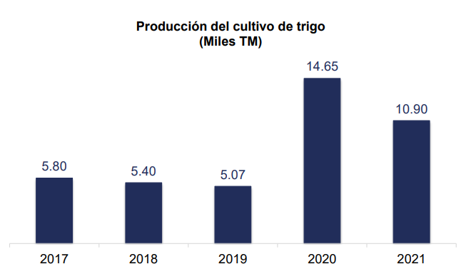
Source: National Institute of Statistics and Censuses – ESPAC 2021 Prepared by: Products and Services Analysis Sub-Management
Ecuador is a minor producer of wheat[2]. Only 1.13% of national demand comes from the Ecuadorian countryside. The rest is imported, mainly, from Canada, the United States and Argentina.
National wheat production in 2021 decreased by 26%. Likewise, it was observed that the province of Carchi leads 55% as a producing species and 39% in harvested area nationwide.
There are 694,000 tons that are demanded per year in Ecuador for various uses in milling, according to data from the Ministry of Agriculture. In Ecuador, 78% of imported wheat is used for milling to make flour, and of that segment, 55% is used to produce bread and 24% for pasta.
In 2021, Ecuador imported $589M in Wheat, becoming the 27th largest importer of Wheat in the world. In the same year, Wheat was the number 6 most imported product in Ecuador, mainly from: Canada ($406M), United States ($113M), and Argentina ($69.9M).
Ref: https://oec.world/es/profile/bilateral-product/wheat/reporter/ecu
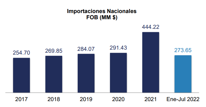
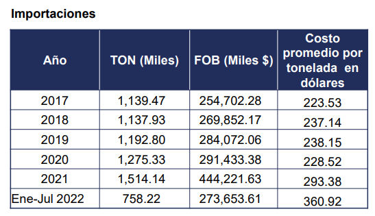
The import of wheat into Ecuador during 2021 was $444.22 MM FOB, 52% higher than in 2020.
According to the Ecuadorian temporary law, the importation of wheat is not subject to customs taxes. This tax exemption has been extended until December 31, 2024.
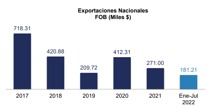
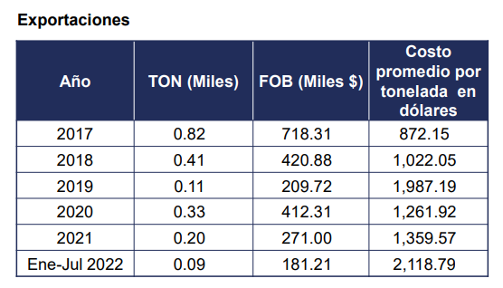
Source: National Institute of Statistics and Censuses – EPAC 2021 Prepared by: Products and Services Analysis Sub-Management
In 2021, the wheat sector exported $271 Thousand FOB, showing a drop of 34% compared to 2020. As of July 2022, exports were recorded for the value of $181.21 Thousand FOB, equivalent to 67% of what was reported in all year 2021.
Ecuadorian Association of Millers ASEMOL
The Ecuadorian Association of Millers “ASEMOL” brings together the main key companies in the sector.
- Molinos Miraflores, http://www.molinosmiraflores.com/
- Industrial Molinera, industrialmolinera.com
- Buenaño y Caicedo Cía. de Negocios Ciudadela Católica - Cuenca
- 593-7 234-1015
- Molinos San Luis, molinosanluis.com
- Grupo Superior, gruposuperior.com
- Industrias Catedral, industriascatedral.com
- Molinos Poultier, molinospoultier.com
- Industrias y Molinos Quito Cia. Ltda. Marca registrada http://molinosroyal.com/
- La Industria Harinera, santa-lucia.ec
- Fábrica de Alimentos, FALIMENSA https://falimensa.com/
- Moderna Alimentos S.A., moderna.com.ec
President of ASEMOL: Álvaro Fernando Sánchez, (Successors of J. Paredes M.S.A.)
Av. De La Prensa N56-87 and Pasaje Manuel Herrera. Quito, Ecuador
Telephones: (593-2) 2442519 (593-2) 2469369
The main companies dedicated to the industrialization of wheat are Molinera Miraflores de Ambato, Molinos San Luis de Carchi, Molinos E. Industrias de Quito, Industrial Molinera C.A. of Guayaquil, Industria Harinera S.A. de Santa Lucía (Industria Harinera S.A.), Wheat flour mill in Riobamba, Molinera Manta, Industria Catedral S.A., Impor-Export Castro, Agroange and Disprac: Distributor of wheat products.
For more information on milling company contact details, please see the following link: 4.6 Storage and Milling Companies Contact List.
[2] Few countries are self-sufficient in wheat: China is the world's largest producer of wheat, but it is also the world's largest importer.