2 Bolivia Logistics Infrastructure
Bolivia Logistics Infrastructure
In almost a decade (2004 - 2013), resources in the General State
Budget rose approximately 380% in construction; road maintenance,
650%; in the water sector, 780%; in energy, and the biggest public
investment was allocated to telecommunications, namely 40.000 %,
with the purchase, placing in orbit and construction of 3 satellite
earth stations, for communication.
The following information is extracted from the report by the
Confederation of Private Entrepreneurs of Bolivia, "Investment and
Growth" – 2013”:
Within the public investment in infrastructure, transport is the
area receiving more resources, related largely to road
construction. In geographical terms, departmental road networks
have shown the highest growth rate, with an increase in its
extension of more than 300%, while the basic road network roads
have had an increase of 120% and municipal roads of barely 50%.
Investment in water resources (mainly irrigation) has had a better
performance, because between 1990 and 2012 investment in this
sector has risen more than 19 times.
In recent years, investment in the productive sector has shown a
significant increase, especially by the high prices of minerals
with respect to their role in the economy, mainly in the mining and
hydrocarbons extraction area. In nominal terms, public investment
in mining has increased more than 46 times between 1990 and 2012,
and the hydrocarbons sector has grown 381, 9% in the same
period.
Social investment (which includes the health, education, housing
and basic sanitation sectors) generated a change in investment due
to the administrative decentralization in 1995. Housing and urban
development sector receives a greater amount of investment
resources, representing 32.6% of the total investment in that
period, while education accounted for 30.8%, health fell to 17.9%,
and basic sanitation accounted for 18.6%.
2.1 Bolivia Port Assessment
Bolivia Port Assessment

For information on Bolivia Ports, please see the following links:
2.1 Chile Port of Puerto Arica (English)
2.1.1 Peru Port of Matarani (English)
2.2 Bolivia Aviation
Bolivia Aviation

Dirección General de Aeronáutica Civil DGAC, is the Civil Aviation Authority in Bolivia, dependent of the Vice Ministry of Communications and Civil Aeronautics, responsible for the control, regulation of the civil aeronautical activities and the aero-commercial exploitation.
The agency responsible for the administration of public aerodromes of support services, air navigation protection and control of the airspace over national territory, is the Administradora de Aeropuertos y Servicios Auxiliares de la Navegación Aérea AASANA (Administrator of Airports and Auxiliary Services of Air Navigation), being in control of the total or partial concession of controlled airports, and of public use.
For information on Bolivia aviation Contact details, please see the following link:
4.5 Bolivia Airport Company Contact List
GLCSC LCA BOLIVIA Ground Companies CBBA 140930
GLCSC LCA BOLIVIA Ground Companies LPZ 140930
GLCSC LCA BOLIVIA Ground Companies SCZ 140930
Procedures for Foreign Registered Aircraft
Send a Request to the Executive Director of DGAC, mentioning the following information
- Name or trade name of the operator
- Commercial Address, Telephone and Fax of the Operator
- Type and Registration of the aircraft
- PBMD (MTOW) of the Aircraft
- Pilot (crew)
- Date of Entry
- Airport Entrance to Bolivia
- Exit Airport from Bolivia
- Last Landing Airport before entering Bolivia
- Flight Purpose
- Number of Passengers
- Type and load weight (if applicable)
- Date of Exit of Bolivia
With the authorization response, go to the offices of the Civil Aeronautic General Direction to proceed with the registration. After the arrival of the aircraft at the airport of entry, the DGAC personnel shall proceed to the corresponding inspection and verification of the documentation
The documentation to be submitted is as follows:
- Certificate of registration of the aircraft
- Certificate of existing airworthiness of the aircraft
- Insurance Policy of the Aircraft in effect, including geographic boundaries and the registration of the aircraft
- License and medical validity of the crew
If entry operations take place in "EL ALTO" airport of the city of La Paz, the Appendix on Operation in High Altitude shall be attached. (contained in the AFM of the aircraft)
2.2.1 Bolivia ALTO International Airport
Bolivia ALTO International Airport
Second busiest airport which is administered by AASANA, except management and services in land that is administered by El Servicio de Aeropuertos Bolivianos Sociedad Anonima SABSA, recently nationalized by the Bolivian Government.
|
Location Details |
|||
|---|---|---|---|
|
Country |
Bolivia |
Latitude |
-16.513334 |
|
Province / District |
Longitude |
-68.19226 |
|
|
Town or City (Closest) |
Ciudad El Alto |
Elevation (ft and m) |
13,325 ft 4,061 m |
|
Airfield Name |
El Alto |
IATA and ICAO Codes |
SLLP |
|
Open From (hours) |
00:00 |
Open To (hours) |
24:00 |
For further information, please see the following links:
Allmetsat Website for Bolivia Alto International Airport
4.5 Bolivia Airport Company Contact List
Runways
|
Runway #1 |
|
|---|---|
|
Runway Dimensions |
4,000 mtrs x 46 mtrs |
|
Orientation |
10-34 |
|
Surface |
Pavimento rígido |
Helicopter Pad(s)
In Bolivia there are no private helicopter transportation services. The FAB Bolivian Air Force, for its helicopters uses a landing platform of air operations, for military use.
For the specific case of humanitarian support in emergency situations, the following technical solutions are offered:
El Alto La Paz Airport, FAB’s aircraft operations apron is used.
Jorge Wilsterman Cochabamba Airport, FAB’s aircraft operations apron is used.
Tte. A. Jorge Henrich Trinidad Airport, the head 32 of the runway is used because it is strategically controlled by the FAB.
Other airports in the country use the commercial parking platform.
Airport Infrastructure Details
|
Customs |
Yes |
JET A-1 fuel |
Yes |
|---|---|---|---|
|
Immigration |
Yes |
AVGAS 100 |
Yes |
|
Terminal Building |
Yes |
Single Point Refueling |
Yes |
|
Passenger Terminal |
Yes |
Air Starter Units |
Yes |
|
Cargo terminal |
Yes |
Ground Power (mobile) |
Yes |
|
Pax transport to airfield |
No |
Ground Handling Services |
Yes |
|
Control Tower |
Yes |
Latrine Servicing |
Yes |
|
Weather Facilities |
Yes |
Fire Fighting Category (ICAO) |
Yes |
|
Catering Services |
Yes |
De-icing Equipment |
No |
|
Base Operating Room |
Yes |
Parking Ramp Lighting |
Yes |
|
Airport Radar |
Yes |
Approach & Runway Lights |
Yes |
|
NDB |
Yes |
VOR |
Yes |
|
ILS |
Yes |
|
Passenger and Cargo Performance Indicator
|
Performance for (April 2014) |
Annual Figures |
Monthly |
Daily |
|---|---|---|---|
|
Total aircraft movements |
n/a |
627 int 3,298 nat |
n/a |
|
Total passengers |
n/a |
94,418 int 358,158 nat |
n/a |
|
Total capacity of the airport (metric tonnes) |
Concession |
n/a | n/a |
|
Current activity of the airport (metric tonnes) |
Concession |
n/a | n/a |
|
Current use by Humanitarian flights (UNHAS) |
n/a |
n/a | n/a |
The Air Service Operators have storage areas with sufficient capacity for domestic cargo, which has restricted volume due to the cost of the service.
Airport Operating Details
|
Operating Details |
|||
|---|---|---|---|
|
Maximum sized aircraft which can be offloaded on bulk cargo: |
B757 |
||
|
Maximum sized aircraft that can be offloaded on pallet |
B757 |
||
|
Total aircraft parking area (m²) |
Principal 24,486 M2 Load 8,391 M2 (2 parking spaces) |
||
|
Storage Area (mt) |
1,679 M2 |
Cubic Meters (m³) |
n/a |
|
Cargo Handling Equipment Available (Yes / No) |
Yes Terciary service |
If "Yes" specify below |
|
|
Elevators / Hi Loaders (Yes / No) |
Yes |
Max Capacity (mt) |
7.0 |
|
Can elevators / hi loaders reach the upper level of a B747 (Yes / No) |
Yes |
||
|
Loading Ramps (Yes / No) |
Yes |
||
Storage Facilities
ALBO S.A. has the concession contract for the management services of customs warehouses and transit control through bidding GNAF No. 001/2002 called by the National Customs. Tariffs are as follows:
Logistics Service = 0.45% CIF value
Storage = General merchandise = 0.09 USD/KG (period of 15 days)
Hazardous = 1.50 USD/KG (período 15 days)
Container 20´ = 7.0 USD/cont. (de 1 a 15 días)
In Bulk = 0.05 USD/MT per day
Storage Insurance = 0.1% CIF value (period of 30 days)
Grants = 64% of the established tariffs.
Airfield Cost
Navigation Charges
National:
|
Aircraft Weight - MTOW (kg) |
Navigation (per journey) USD - $ |
Landing USD - $ |
Night Landing USD - $ |
Night Take-Off USD - $ |
Parking |
Handling Charges |
|
|---|---|---|---|---|---|---|---|
|
0 |
10.000 |
64.0 (fixed) |
113.91 (fixed) |
30% of landing |
30% of landing |
180 minutes at 24 hours and fraction = 20% landing |
Not quotted |
|
10.001 |
20.000 |
3.66 x Tn |
7.22 |
30% of landing |
30% of landing |
180 minutes at 24 hours and fraction = 20% landing |
Not quotted |
|
20.001 |
And over |
4.83 x Tn |
9.5 |
30% of landing |
30% of landing |
180 minutes at 24 hours and fraction = 20% landing |
Not quotted |
|
Note 1: Schedule of night landing is between 19:01-24:00 hours Note 2: Parking fees are for every 180 minutes to 24 hours or part of this Note 3: All these positions are administered by SABSA and are the same for all the international airports in Bolivia |
|||||||
International:
|
Aircraft Weight - MTOW (kg) |
Navigation (per journey) USD - $ |
Landing USD - $ |
Night Landing USD - $ |
Night Take-Off USD - $ |
Parking |
Handling Charges |
|
|
10.001 |
20.000 |
6.93 x Tn |
6.52 x Tn |
30% of landing |
30% of landing |
180 minutes at 24 hours and fraction = 20% landing |
Not quotted |
|
20.001 |
80,000 |
6.84 x Tn |
6.43 x Tn |
30% of landing |
30% of landing |
180 minutes at 24 hours and fraction = 20% landing |
Not quotted |
|
80,001 |
150,000 |
6.75 x Tn |
6.35 x Tn |
30% of landing |
30% of landing |
180 minutes at 24 hours and fraction = 20% landing |
Not quotted |
|
150,001 |
And over |
5.76 x Tn |
5.42 x Tn |
30% of landing |
30% of landing |
180 minutes at 24 hours and fraction = 20% landing |
Not quotted |
|
Note 1: Schedule of night landing is between 19:01-24:00 hours Note 2: Parking fees are for every 180 minutes to 24 hours or part of this Note 3: These charges are administered by SABSA and are the same for all the international airports in Bolivia |
|||||||
Fuel Services Charges
|
Price per Unit |
|
|---|---|
|
Jet A-1 |
National 1.48 usd/galon 0.39 usd/ltr International 3.58 usd/galon 0.95 usd/ltr |
|
Avgas |
0.68 usd/ltr |
Cargo Terminal Charges
|
Import |
Rate US$ / kg |
|---|---|
|
Handling Charge per kg |
N/A |
|
Break Bulk Fee |
N/A |
|
Diplomatic Mail |
None |
|
Strong Room – per consignment |
N/A |
|
Cold Storage Fee |
N/A |
|
Delivery outside normal working hours |
30% fees |
|
Preparation of substitute AOA – Invoice – Receipt |
12.0 usd/doc |
|
Storage per kg per day – Grace period? hours |
Period of 15 days 0.09 usd/kgr |
|
Export |
Rate US$ / kg |
|
Handling charges – Unpalletized cargo |
N/A |
|
International Air WayBill |
12.0 usd/doc |
|
Local Air WayBill |
12.0 usd/doc |
|
Air Way Bill Amendment - Cancellation |
15.0 usd/doc |
|
Air Way Bill Documentation |
12.0 usd/doc |
|
Diplomatic Mail |
Not subject to collection |
|
Storage charges per kg per day |
Period of15 days 0.09 usd/kgr |
Air-bridge Charges
CICLO DE OPERACION
|
MINUTES |
NATIONAL |
INTERNATIONAL |
|---|---|---|
|
00 - 90 |
40 |
60 |
|
91 - 120 |
48 |
72 |
|
121 - 150 |
56 |
84 |
|
151 - 180 |
64 |
96 |
|
181 - 210 |
72 |
108 |
|
211 - adelante |
80 |
120 |
Security
Good. Guaranteed by the different services provided by SABSA as airport operator in La Paz, Cochabamba and Santa Cruz (Viru Viru airport)
Companies Available
LLOYD AEREO BOLIVIANO (LAB)
Services provided:
- Air Starter
- Ground power unit (GPU)
- Stevedores in platform
- Motorized stair
- Sewage truck
- Water truck
- Tractor trailer
- Tow tractor
- Forklift truck
Information on some aviation service providers can be found at: Azfreight Website for Bolivia
For information on Bolivia aviation Contact details, please see the following link:
4.5 Bolivia Airport Company Contact List
|
|
2.2.2 Bolivia Viru Viru International Airport
Bolivia Viru Viru International Airport
First and busiest airport run by AASANA, except for the management and services in land which are run by the Servicio de Aeropuertos Bolivianos Sociedad Anónima SABSA, recently nationalized by the Bolivian State
|
Location Details |
|||
|---|---|---|---|
|
Country |
Bolivia |
Latitude |
-17.64476 |
|
Province or District |
|
Longitude |
-63.13536 |
|
Town or City (Closest) |
Santa Cruz de la Sierra |
Elevation (ft and m) |
1,225 ft 373 m |
|
Airfield Name |
Viru Viru |
IATA and ICAO Codes |
SLVR |
|
Open From (hours) |
00:00 |
Open To (hours) |
24:00 |
For further information, please see the following links:
Allmetsat Website for Viru Viru International Airport
4.5 Bolivia Airport Company Contact List
Runways
|
Runway #1 |
|
|---|---|
|
Runway Dimensions |
3,500 m x 45 m |
|
Orientation |
16-34 |
|
Surface |
Rigid pavement |
Helicopter Pad(s)
In Bolivia there are no private helicopter transport services. For its helicopters, the Bolivian Air Force (FAB) uses the aircraft operations apron, of military use.
For the specific case of humanitarian support in emergency situations, the following technical solutions are given:
El Alto-La Paz airport, FAB’s aircraft operations apron is used.
Jorge Wilsterman Cochabamba airport, FAB’s aircraft operations apron is used.
Lieutenant A. Jorge Henrich Airport Trinidad , head 32 of the runway is used, because it is strategically controlled by the FAB.
In the rest of the airports in the country, the commercial passenger apron is used.
Airport Infrastructure Details
|
Customs |
Yes |
Jet A-1 |
Yes |
|---|---|---|---|
|
Immigration |
Yes |
AVGAS 100 |
Yes |
|
Terminal Building |
Yes |
Single Point Refueling |
Yes |
|
Passenger Terminal |
Yes |
Air Starter Units |
Yes |
|
Terminal charge |
Yes |
Ground Power (mobile) |
Yes |
|
Pax transport to airfield |
No |
Ground Handling Services |
Yes |
|
Control Tower |
Yes |
Latrine Servicing |
Yes |
|
Weather Facilities |
Yes |
Fire Fighting Category (ICAO) |
Yes |
|
Catering Services |
Yes |
De-icing Equipment |
No |
|
Base Operating Room |
Yes |
Parking Ramp Lighting |
Yes |
|
Airport Radar |
Yes |
Approach & Runway Lights |
Yes |
|
NDB |
Yes |
VOR |
Yes |
|
ILS |
Yes |
|
Yes |
Passenger and Cargo Performance Indicator
|
Performance for (April 2014) |
Annual Figures |
Monthly |
Daily |
|---|---|---|---|
|
Total aircraft movements |
n/a |
627 int 3,298 nat |
n/a |
|
Total passengers |
n/a |
94,418 int 358,158 nat |
n/a |
|
Total capacity of the airport (metric tonnes) |
Concession |
n/a |
n/a |
|
Current activity of the airport (metric tonnes) |
Concession |
n/a |
n/a |
|
Current use by Humanitarian flights (UNHAS) |
n/a |
n/a |
n/a |
Air services companies have covered storage areas with sufficient capacity for domestic cargo, which has restricted volumes due to the cost of the service.
Airport Operating Details
|
Operating Details |
|||
|---|---|---|---|
|
Maximum sized aircraft which can be offloaded on bulk cargo: |
DC-10 |
||
|
Maximum sized aircraft that can be offloaded on pallet |
DC-10 / B757 |
||
|
Total aircraft parking area (m²) |
Main 72,750m2 Load 12,330 m2 |
||
|
Storage Area (mt) |
718,68 m2 |
Cubic Meters (m³) |
n/a |
|
Cargo Handling Equipment Available (Yes / No) |
Yes Service provided by third parties |
If "Yes" specify below below |
|
|
Elevators / Hi Loaders (Yes / No) |
Yes |
Max Capacity (mt) |
15.0 |
|
Can elevators / hi loaders reach the upper level of a B747? (Yes / No) |
Yes |
||
|
Loading Ramps (Yes / No) |
Yes |
||
Storage Facilities
ALBO S.A. has the concession contract for the management services of customs warehouses and transit control through bidding GNAF No. 001/2002 called by the National Customs. Tariffs are as follows:
Logistic service = 0.45% CIF value
Storage = General merchandise = 0.09 USD/KG (15 days)
Hazardous merchandise = 1.50 USD/KG (15 days)
Container 20´ = 7.0 USD/cont. (1 to 15 days)
Bulk = 0.05 USD/m per day
Storage insurance = 0.1% (period of 30 days) CIF value
Donations = 64% of the established fees.
Airfield Cost
Navigation Charges
National
|
Aircraft Weight - MTOW (kg) |
Navigation (per journey) USD - $ |
Landing USD - $ |
Night Landing USD - $ |
Night Take-Off USD - $ |
Parking |
Handling Charges |
|
|---|---|---|---|---|---|---|---|
|
0 |
10,000 |
64.0 (fixed) |
113.91(fixed) |
30% landing cost |
30% landing cost |
180 minutes to 24 hours and fraction = 20% landing |
Not listed |
|
10,001 |
20,000 |
3.66 x Tn |
7.22 |
30% landing cost |
30% landing cost |
180 minutes to 24 hours and fraction = 20% landing |
Not listed |
|
20,001 |
And over |
4.83 x Tn |
9.5 |
30% landing cost |
30% landing cost |
180 minutes to 24 hours and fraction = 20% landing |
Not listed |
|
Note 1: Night landing hours are between 19:01 – 24:00 h hours Note 2: Parking charges are for 180 minutes to 24 hours or part thereof Note 3: All of these charges are administered by SABSA and are the same for all international airports in Bolivia |
|||||||
International
|
Aircraft Weight - MTOW (max take-off weight)(kg) |
Navigation (per journey) USD $ |
Landing USD $ |
Night Landing USD $ |
Night Take-Off USD $ |
Parking |
Handling Charges |
|
|---|---|---|---|---|---|---|---|
|
0 |
10,000 |
48.0 usd (fixed) |
45.53 usd |
30% landing cost |
30% landing cost |
180 minutes to 24 hours and fraction = 20% landing |
Not listed |
|
10,001 |
20,000 |
6.93 x Tn |
6.52 x Tn |
30% landing cost |
30% landing cost |
180 minutes to 24 hours and fraction = 20% landing |
Not listed |
|
20,001 |
80.000 |
6.84 x Tn |
6.43 x Tn |
30% landing cost |
30% landing cost |
180 minutes to 24 hours and fraction = 20% landing |
Not listed |
|
80.001 |
150.000 |
6.75 x Tn |
6.35 x Tn |
30% landing cost |
30% landing cost |
180 minutes to 24 hours and fraction = 20% landing |
Not listed |
|
Note 1: Night landing hours are between 19:01 – 24:00 h hours Note 2: Parking charges are for 180 minutes to 24 hours or part thereof Note 3: All of these charges are administered by SABSA and are the same for all international airports in Bolivia |
|||||||
Fuel Services Charges
|
|
Price per Unit |
|---|---|
|
Jet A-1 |
National 1.48 usd/gallon 0.39 usd/lt International 3.58 usd/gallon 0.95 usd/lt |
|
Avgas |
0.68 usd/lt |
Cargo Terminal Charges
|
Import |
Rate US$ / kg |
|---|---|
|
Handling Charge per kg |
n/a |
|
Break bulk (MT) |
n/a |
|
Diplomatic Mail |
n/a |
|
Strong Room - per consignment |
n/a |
|
Cold Storage Fee |
n/a |
|
Delivery outside normal working hours |
n/a |
|
Preparation of substitute AOA - Invoice - Receipt |
12.0 usd/doc |
|
Storage per kg per day – Grace period? hours |
15 days period 0.09 usd/kg |
|
Export |
Rate US$ / kg |
|
Handling charges – Unpalletized cargo |
12.0 usd/doc |
|
International AirWay Bill |
12.0 usd/doc |
|
Local Air WayBill |
15.0 usd/doc |
|
Air Way Bill Amendment - Cancellation |
12.0 usd/doc |
|
Air Way Bill Documentation |
Not subject to collection |
|
Diplomatic Mail |
15 days period 0.09 usd/kg |
|
Storage charges per kg per day |
n/a |
Air-bridge Charges
OPERATIONS CYCLE
|
MINUTES |
NATIONAL |
INTERNATIONAL |
|---|---|---|
|
00 - 90 |
40 |
60 |
|
91 - 120 |
48 |
72 |
|
121 - 150 |
56 |
84 |
|
151 - 180 |
64 |
96 |
|
181 - 210 |
72 |
108 |
|
211 - on |
80 |
120 |
Security
Good, guaranteed by the different services provided by SABSA as airport operator in the airports of La Paz, Cochabamba and Santa Cruz (Viru Viru).
Companies Available
SABSA
Services provided:
- Approach bridge
- Ground power unit
- Conveyor
- Water truck
- Sewage truck
- Pallet lift
- Motorized stair
- Pull bar
- Luggage carrier
- Tractor tráiler
Information on some aviation service providers can be found at:
Azfreight website for Bolivia Viru Viru Airport
For information on Bolivia aviation Contact details, please see the following link:
4.5 Bolivia Airport Company Contact List
2.2.3 Bolivia Jorge Wilsterman National Airport
Bolivia Jorge Wilsterman National Airport
International Airport operable all year-round, routes distributor inside the country because of its geographical location, at the center of Bolivia. Because it is very close to the town, it has two runways. It has all the requirements of navigation aid and aircraft ground services.
Allmetsat Website information for Jorge Wilsterman Airport
For information on Bolivia aviation Contact details, please see the following link:
4.5 Bolivia Airport Company Contact List
|
Airport Details |
|||
|---|---|---|---|
|
Country |
Bolivia |
Latitude |
-17.41357 |
|
Province or District |
Cochabamba |
Longitude |
-66.17713 |
|
Airport Name |
Jorge Wilsterman |
Elevation (ft) |
8,360 ft 2,548 m |
|
IATA and ICAO Codes |
SLCB |
Surface |
Flexible pavement Flexible pavement |
|
Town or City (Closest) |
Cochabamba (capital) |
Runway Condition |
Operable throughout the year |
|
NGO / UN (on ground) |
N/A |
Passenger / Cargo Security Screening (Yes / No) |
Yes |
|
Runway Dimensions |
2,650 x 45 m 3,800 x 45 |
Ground Handling (Yes / No) |
Yes |
|
Refueling Capacity |
Yes, through pits |
Runway Lighting (Yes / No) |
Yes |
|
Runway Heading |
04 – 22 14 - 32 |
Fire Fighting Equipment (Yes / No) |
Yes |
|
Air Traffic Control (Yes / No) |
Yes |
(Yes / No) |
Yes |
|
Weather Information (Yes / No) |
Yes |
Aircraft Parking space (Yes / No) |
Yes |
|
Navigation Aids (Yes / No) |
Yes |
Perimeter fencing (Yes / No) |
Yes |
Fuel Services Charges
|
|
Price per Unit |
|---|---|
|
Jet A-1 |
National 1.48 usd/gallon 0.39 usd/l International 3.58 usd/gallon 0.95 usd/l |
|
Avgas |
0.68 usd/l |
Royalties / Non Objection Fees (NOFs)
Tariffs are regulated by the Superintendence of Transport of Bolivia and applicable to the airports managed by AASANA.
GLCSC LCA BOLIVIA Aeropuertos y Aer+¦dromos 140930
GLCSC LCA BOLIVIA Clasificacion aerodromos AASANA 140930
2.2.4 Bolivia Cap. Selin Zeitun Lopez National Airport
Bolivia Cap. Selin Zeitun Lopez
National Airport
National airport operable all year long, with connections to the north of the country because of its geographical location. It has all the requirements of navigation aid and small aircraft ground services.
Allmetsat Website for Cap. Selin Zeitun Lopez National Airport
For information on Bolivia aviation Contact details, please see the following link:
4.5 Bolivia Airport Company Contact List
|
Airport Details |
|||
|---|---|---|---|
|
Country |
Bolivia |
Latitude |
-11.01545 |
|
Province or District |
Riberalta |
Longitude |
-66.10371 |
|
Airport Name |
Selin Zeitun Lopez |
Elevation (ft) |
462 ft |
|
IATA and ICAO Codes |
SLRI |
Surface |
Flexible pavement |
|
Town or City (Closest) |
Ciudad de Riberalta (capital) |
Runway Condition |
Operable throughout the year |
|
NGO / UN (on ground) |
N/A |
Passenger / Cargo Security Screening (Yes / No) |
Yes |
|
Runway Dimensions |
1,800 x 30 m |
Ground Handling (Yes / No) |
Yes |
|
Refueling Capacity |
Yes |
Runway Lighting (Yes / No) |
Yes |
|
Runway Heading |
13 - 31 |
Fire Fighting Equipment (Yes / No) |
Yes |
|
Air Traffic Control (Yes / No) |
Yes |
(Yes / No) |
Yes |
|
Weather Information (Yes / No) |
Yes |
Aircraft Parking space (Yes / No) |
Yes |
|
Navigation Aids (Yes / No) |
Yes |
Perimeter fencing (Yes / No) |
Yes |
Fuel Services Charges
|
|
Price per Unit |
|---|---|
|
Jet A-1 |
National 1.48 usd/gallon 0.39 usd/l International 3.58 usd/gallon 0.95 usd/l |
|
Avgas |
0.68 usd/l |
Royalties / Non Objection Fees (NOFs)
Tariffs are regulated by the Superintendence of Transport of Bolivia and applicable to the airports managed by AASANA.
GLCSC LCA BOLIVIA Aeropuertos y Aerodromos 140930
GLCSC LCA BOLIVIA Clasificacion aerodromos AASANA 140930
2.2.5 Bolivia Jorge Henrich Arauz National Airport
Bolivia Jorge Henrich Arauz National Airport
National Airport operable all year-round, routes distributor to the North of the country because of its geographical location, at the southeast center of Bolivia. It has all the requirements of navigation aid and aircraft ground services.
Allmetsat Website for Jorge Henrich Arauz National Airport
For information on Bolivia aviation Contact details, please see the following link:
4.5 Bolivia Airport Company Contact List
|
Airport Details |
|||
|---|---|---|---|
|
Country |
Bolivia |
Latitude |
-14.82436 |
|
Province or District |
Trinidad |
Longitude |
-64.92368 |
|
Airport Name |
Jorge Henrich Arauz |
Elevation (ft) |
509 ft 155 m |
|
IATA and ICAO Codes |
SLTR |
Surface |
Flexible pavement |
|
Town or City (Closest) |
Ciudad de Trinidad (capital) |
Runway Condition |
Operable throughout the year |
|
NGO / UN (on ground) |
N/A |
Passenger / Cargo Security Screening (Yes / No) |
Yes |
|
Runway Dimensions |
2.400 x 30 m |
Ground Handling (Yes / No) |
Yes |
|
Refueling Capacity |
Yes |
Runway Lighting (Yes / No) |
Yes |
|
Runway Heading |
14 - 32 |
Fire Fighting Equipment (Yes / No) |
Yes |
|
Air Traffic Control (Yes / No) |
Yes |
(Yes / No) |
Yes |
|
Weather Information (Yes / No) |
Yes |
Aircraft Parking space (Yes / No) |
Yes |
|
Navigation Aids (Yes / No) |
Yes |
Perimeter fencing (Yes / No) |
Yes |
Fuel Services Charges
|
|
Price per Unit |
|---|---|
|
Jet A-1 |
National 1.48 usd/gallon 0.39 usd/l International 3.58 usd/gallon 0.95 usd/l |
|
Avgas |
0.68 usd/l |
Royalties / Non Objection Fees (NOFs)
Tariffs are regulated by the Superintendence of Transport of Bolivia and applicable to the airports managed by AASANA.
GLCSC LCA BOLIVIA Aeropuertos y Aerodromos 140930
GLCSC LCA BOLIVIA Clasificacin aerodromos AASANA 140930
2.3 Bolivia Road Network
Bolivia Road Network

GLCSC LCA BOLIVIA Mapa Red Vial Fundamental 140930
For information on Bolivia road network contact details, please see the following link:
4.2.1 Bolivia Government Contact List
The basic Road Network has an extension of 16.054,35 km and it
runs all over the country. Five main corridors constitute it: East
- West, North - South, West - North West - South and Central -
South.
The purpose of these corridors is to connect the national territory
and integrate the Bolivian population; but essentially push through
these economic, social and productive development of all and each
of the Bolivian regions.
The basic Road Network (RVF) is part of the National Highway System
and is under the responsibility of the Bolivian Road Administrator
(ABC).
Article 2 of the Supreme Decree No. 25134 establishes that the
routes that make up the RVF are those that connect the political
capitals of departments; they allow the international linkage,
connecting national highways with the main routes of neighboring
countries; connect two or more roads and comply with the conditions
of environmental protection laid down in national legislation.
|
Classification |
Road Description |
|---|---|
|
Type: Route 1, National |
From the border of Perú (Desaguadero) to the border of Argentina (Bermejo). 1,215 KM, paved 902 KM and 313 with ravel. It connects the capitals of the Departments of Oruro, Potosí and Tarija. Stable and open throughout the year. |
|
Type: Route 2, National |
From the border of Perú (Kasani) to El Alto La Paz. 155 KM paved. Stable and open throughout the year. |
|
Type: Route 3, National |
It connects the capitals of the Department of La Paz with Trinidad. 602 KM, 84 KM paved, 302 with ravel and 216 KM earth road. The stretch with the earth's surface is interrupted by flooding in the rainy season (December - April). |
|
Type: Route 4, National |
It connects the border of Chile (Tambo Quemado) the capitals of the West - East, La Paz, Cochabamba & Santa Cruz, until it gets to the border of Brazil (Arroyo Concepción).Total length 1,657 KM, 923 KM paved, 184 gravel and 550 KM earth road. Stable and open throughout the year on paved and gravel. The earth route is interrupted during rainy season (December – April). |
|
Type: Route 9, National |
From the border with Argentina (Pocitos) to the border of Brazil (Guayaramerín). 1,631 KM out of which 927 KM are paved, 197 KM with gravel and 506 KM earth road. The earth road is sometimes interrupted during rainy season. (December - April). |
|
Type: Route 12, National |
From the border with Chile (Pisiga) to Oruro. 279 KM, 84 KM paved and 195 KM gravel. Open all year long. It connects Oruro to all the capitals of Department |
|
Type: Route 14, National |
From the border of Argentina (Villazón) to Potosí (Cuchu Ingenio). 316 KM with gravel, stable and open all year long. From Potosí it connects all the capitals of the Department. |
|
Type: Route 19, National |
From the border with Chile (Charaña) to El Alto La Paz. 211 KM of gravel, open all year long. It connects El Alto La Paz to all the capitals of Department. |
Distance Matrix
|
DISTANCES FROM CAPITAL CITY TO MAJOR TOWNS (Km) |
||||||||
|---|---|---|---|---|---|---|---|---|
|
|
La Paz |
Oruro |
Potosí |
Sucre |
Tarija |
Cochabamba |
Santa Cruz |
Trinidad |
|
La Paz |
|
230 |
551 |
698 |
919 |
383 |
851 |
602 |
|
Oruro |
230 |
|
321 |
349 |
689 |
212 |
680 |
832 |
|
Potosi |
551 |
321 |
|
164 |
368 |
530 |
774 |
1153 |
|
Sucre |
698 |
349 |
164 |
|
480 |
366 |
610 |
1317 |
|
Tarija |
919 |
689 |
368 |
480 |
|
846 |
710 |
1685 |
|
Cochabamba |
383 |
212 |
530 |
366 |
846 |
|
468 |
1063 |
|
Santa Cruz |
851 |
680 |
774 |
610 |
710 |
468 |
|
595 |
|
Trinidad |
602 |
832 |
1153 |
1317 |
1685 |
1063 |
595 |
|
Travel Time Matrix
|
TRAVEL TIME FROM CAPITAL CITY TO MAJOR TOWNS (hours / Days) |
||||||||
|---|---|---|---|---|---|---|---|---|
|
|
La Paz |
Oruro |
Potosí |
Sucre |
Tarija |
Cochabamba |
Santa Cruz |
Trinidad |
|
La Paz |
|
3.0 |
7.0 |
9.0 |
12.0 |
6.0 |
11.0 |
17.0 |
|
Oruro |
3.0 |
|
5.0 |
7.0 |
9.0 |
3.0 |
8.0 |
14.0 |
|
Potosi |
7.0 |
5.0 |
|
2.0 |
5.0 |
8.0 |
13.0 |
19.0 |
|
Sucre |
9.0 |
7.0 |
2.0 |
|
7.0 |
10.0 |
15.0 |
21.0 |
|
Tarija |
12.0 |
9.0 |
5.0 |
7.0 |
|
13.0 |
18.0 |
24.0 |
|
Cochabamba |
6.0 |
3.0 |
8.0 |
10.0 |
13.0 |
|
5.0 |
11.0 |
|
Santa Cruz |
11.0 |
8.0 |
13.0 |
15.0 |
18.0 |
5.0 |
|
6.0 |
|
Trinidad |
17.0 |
14.0 |
19.0 |
21.0 |
24.0 |
11.0 |
6.0 |
|
Road Security
Conservation Road with Microenterprises Program - PROVIAL is in charge of the management and control of micro-enterprises who perform road maintenance activities, and aims at preventing premature deterioration of the roads.
Among its main activities are: cleaning of ditches, gutters, downspouts, clearing, repair and construction of walls and others.
Weighbridges and Axle Load Limits
Decree Supreme # 25629 of December 24th,1999, establishes the control regulation of weights and dimensions of vehicles travelling on the roads of the country
|
Axle load limits |
LCA Country |
Transit Country |
Transit Country |
|---|---|---|---|
|
Truck with 2 axles |
18,000 |
7 / 11 |
1RS-1RD |
|
Truck with 3 axles |
25,000 |
7 / 18 |
1RS-2RD |
|
Truck with 4 axles |
32,000 |
7 / 25 |
1RS-3RD |
|
Semi-trailer with 3 axles |
29,000 |
7 / 11 / 11 |
1RS-1RD-1RD |
|
Semi-trailer with 4 axles |
36,000 |
7 / 11 / 18 |
1RS-1RD-2RD |
|
Semi-trailer with 5 axles |
39,000 |
7 / 11 / 21 |
1RS-1RD-1RS-2RD |
|
Semi-trailer with 6 axles |
45,000 |
7 / 18 / 25 |
1RS-2RD-3RD |
|
Truck & drawbar trailer with 4 axles |
40,000 |
7 / 11 / 11 / 11 |
1RS-1RD-1RD-1RD |
|
Truck & drawbar trailer with 5 axles |
45,000 |
7 / 11 / 11 / 18 |
1RS-1RD-1RD-2RD |
|
Truck & drawbar trailer with 6 axles |
45,000 |
7 / 18 / 11 / 18 |
1RS-2RD-1RD-2RD |
|
Truck & drawbar trailer with 7 axles |
45,000 |
7 / 7 / 25 / 11 / 18 |
1RS-3RD-1RD-2RD |
GLCSC LCA BOLIVIA Limites de peso transporte Comunidad Andina 140930
GLCSC LCA BOLIVIA Tolerancia peso carreteras Chile 140930
Road Class and Surface Conditions
GLCSC LCA BOLIVIA Mapa Longitud RVF 140930
GLCSC LCA BOLIVIA Mapa Corredores RVF 140930
2.4 Bolivia Railway Assessment
Bolivia Railway Assessment

GLCSC LCA BOLIVIA Mapa ferroviario zona andina 140930
GLCSC LCA BOLIVIA Mapa Ferroviario zona oriental 140930
According to the current mode of operation, the State retains ownership of all routes and fixed installations, as well as perceives tax rates for the grant, license and rental of rolling stock; on its part the awarded company commits itself to manage services according to the requirements stipulated in the contract, fulfilling the regulations of the Superintendence of Transport.
The current railway system in Bolivia is managed by the private sector, according to contracts signed by the Bolivian Government
For information on Bolivia railway network contact details, please see the following link:
4.1 Bolivia Government Contact List
4.10 Bolivia Railway Company Contact List
Travel Time Matrix
|
Travel Time from Capital City to Major Towns (Hours / Days) |
||||||||
|---|---|---|---|---|---|---|---|---|
|
Oruro |
El Alto |
Viacha |
Potosí |
Uyuni |
Avaroa |
Villazón |
Charaña |
|
|
Oruro |
|
6 |
4 |
12 |
12 |
17 |
15 |
14 |
|
El Alto |
6 |
2 |
19 |
19 |
27 |
32 |
8 |
|
|
Viacha |
4 |
2 |
17 |
17 |
25 |
30 |
6 |
|
|
Potosí |
12 |
19 |
17 |
12 |
17 |
25 |
20 |
|
|
Uyuni |
12 |
19 |
17 |
12 |
5 |
13 |
23 |
|
|
Avaroa |
17 |
27 |
25 |
17 |
5 |
18 |
31 |
|
|
Villazón |
25 |
32 |
30 |
25 |
13 |
18 |
37 |
|
|
Charaña |
14 |
8 |
6 |
20 |
23 |
31 |
37 |
|
Railway Companies and Consortia
Andean Railway Company S.A. established in Bolivia, administered and operated by its own workers and executives, autonomous and private.
Freight rates as well as passenger rates are regulated and approved by the Superintendence of Transport. These have ranges according to the type of load, on the basis of the load classifier and directly based on the distance.
Freight rates are currently below the maximum reference rates approved by the Superintendence of Transport, due to land transport competition, looking for a better positioning of services, the type of product, tonnage, distance, regularity of service, rotation of the rolling stock and the uptake of larger volumes, which use other transportation means.
The strategy to compete with road transport, despite the comparative advantage of the transport door to door, its low fixed costs and its informality, is that FCA can move large volumes of load and search the flexibility to perform the bimodal transport.
They have the authorization of the Vice Ministry of Transport, enabling them as OTM (Multimodal Transport Operator) and the Foreign Trade Operator License issued by the National Customs.
Capacity Table
|
FCASA |
|
|---|---|
|
Operates on (lines) |
National |
|
Max train length and/or pulling capacity |
1,452 km |
|
Locomotives (electric/diesel/steam) |
18 diesel |
|
Freight Wagons (covered) / size |
614 m3 |
|
Freight Wagons (flat bed) / size |
20 max for 40 ft container |
|
Freight Wagons (high-sided)/size |
None |
|
Freight Wagons (drop-side)/size |
None |
Key Route Information
|
Route Villazon - Oruro |
Route Avaroa - Oruro |
Route Charaña – Oruro |
|
|---|---|---|---|
|
Track gauge |
1.0 mtr |
1.0 mtr |
1.0 mtr |
|
Ruling gradient |
5% |
3% |
3% |
|
Total track distance (single and/or double) |
602 |
486 |
412 |
|
Type of rail (weight and if welded or not) |
There isn’t another railway |
There isn’t another railway |
There isn’t another railway |
|
Type of sleeper and fastenings |
Rigid Fixations. Elastic Fixation |
Rigid Fixations. Elastic Fixation |
Rigid Fixations. Elastic Fixation |
|
Total track travel time |
15 |
17 |
14 |
|
Maintenance (Good, marginal, bad) |
Good |
Good |
Good |
|
Companies-consortiums operating on line |
None |
None |
None |
|
Traffic frequency (monthly/weekly/daily) |
weekly |
weekly |
weekly |
|
Security (Good, marginal, bad) |
good |
good |
Good |
|
Main stations (Add details below) |
Uyuni Tupiza |
Uyuni |
Viacha |
Rigid attachments - which get nailed or screwed into the sleeper/heavy beam.
Elastic fasteners-the Pandrol Clips consist of a sleeper anchor element and an elastic element that works under combined bending and torsion, manufactured of high quality steel bar.
The Clip is applied parallel to the rail and its placement and removal is done with a lag.
Uyuni Workshop: The main activity is oriented to the maintenance and repair of the equipment being towed from the Park of the company (in general cargo wagons).
Viacha Workshop: specializing in repair, maintenance and overhaul of locomotives, diesel, electric LDE
Key Stations
|
Key Station Information |
|||
|---|---|---|---|
|
Villazon |
Uyuni |
Charaña |
|
|
Location |
Villazon City– Borders with Argentina |
Uyuni City |
Charaña City – Borders with Chile |
|
Contact Information |
|||
|
Connections with other transport means (road/waterways/air) |
Highway: Northern Argentina, Tupiza |
Railroad: Avaroa Borders with Chile, Potosi, Tupiza |
Highway: Arica Chile Railroad Arica Chile |
|
Storage Capacity (square meters and cubic meters) |
n/a |
350 M2 |
n/a |
|
Handling Equipment |
n/a | n/a | n/a |
|
Handling Capacity: MT / Hour TEU / Hour |
n/a | n/a | n/a |
|
Other Comments |
n/a | n/a | n/a |
Empresa Ferroviaria Oriente S.A.
Ferroviaria Oriental S.A. operates in the East of Bolivia, connecting the city of Santa Cruz de la Sierra with Argentina via Yacuiba - Pocitos; with Brazil through Puerto Suárez - Quijarro - Corumbá; and with the North, Warnes and Montero. The railway network has a 1,244 kms of wide meter gauge, of which 643 km correspond to the Eastern sector, 539 kilometers to the Southern sector and 62 kilometers to the Northern Sector of the Department. The network allows access to the Eastern Atlantic ports of: Santos and Paranagua, in Brazil, by this sector through the routes of ALL (America Latina Logistics); and the ports of Buenos Aires and Rosario, in Argentina, by the Southern sector in connection with Belgrano Cargas. Furthermore, the Paraguay – Paraná Waterway, on the basis of an intermodal transportation system allows access to the same ports of Argentina and the port of Nueva Palmira, Uruguay. Finally, in the southern sector by the passage of Salta to Socompa in connection with the route of Belgrano Cargas, you can access the port of Antofagasta in Chile.
DEVELOPMENT PROJECTS- GE LOCOMOTIVES-in November of 2013, Ferroviaria Oriental purchased locomotives from General Electric; these are three C23EMP locomotives of latest generation which will be delivered by the end of 2014. The Units come equipped with a turbo diesel engine with electronic injection, microprocessor, remote synchronization system and events register camera.
PURCHASE OF WAGONS- As an investment, 80 flat carts were bought from the company Ferrocarriles Españoles de Via Estrecha - FEVE, and 100 containers of 40 feet each were transformed into removable grain wineries, with a fast download design for exclusive use in transportation of soybean grain, strengthening the loading capacity in 120,000 additional tons per year for the next management.
INFRASTRUCTURE- In 2013 there were improvements to the infrastructure in different parts of the network, covering works and projects in the Northern, Southern and Eastern sectors. Executed trail works included the placement of 36.196 sleepers of wood, the addition of 159.838 elastic fasteners (clips) and the incorporation of 20.902 m3 of ballast, thus eliminating deficient trail sections and sectors and continuing with the process of replacing the sections of track over land by others with ballast, thus improving the bearing track capacity and giving greater stability and drainage capacity.
The mechanized leveling of 170 Km was done in the Eastern sector, achieving substantial improvement of geometry (leveling and alignment) of the trail. In addition, there was an intensive improvement and maintenance of 88 km of the route in three sectors. The Change of Rails Project totaled 2.5 Km of change of rails of 90 pounds per yard, which replaced 65 lb/yd of rails. The program of aluminum thermal welding designed to provide comfort and security to the movement of trains, recorded a total of 10.6 Km.
General Information
Total Length = 1,244 km
Per branch:
North Sector: Santa Cruz – Montero = 62 km
South Sector: Santa Cruz – Yacuiba (border with Argentina) = 539 km
East Sector: Santa Cruz – Puerto Quijarro (border with Brasil) = 643 km
Stations:
South Sector: Santa Cruz – Abapo – Charagua – Boyuibe – Villa Montes – Yacuiba
East Sector: Santa Cruz – Tres Cruces – San Jose de Chiquitos – Robore – Puerto Suarez – Puerto Quijarro
2.5 Bolivia Waterways Assessment
Bolivia Waterways Assessment

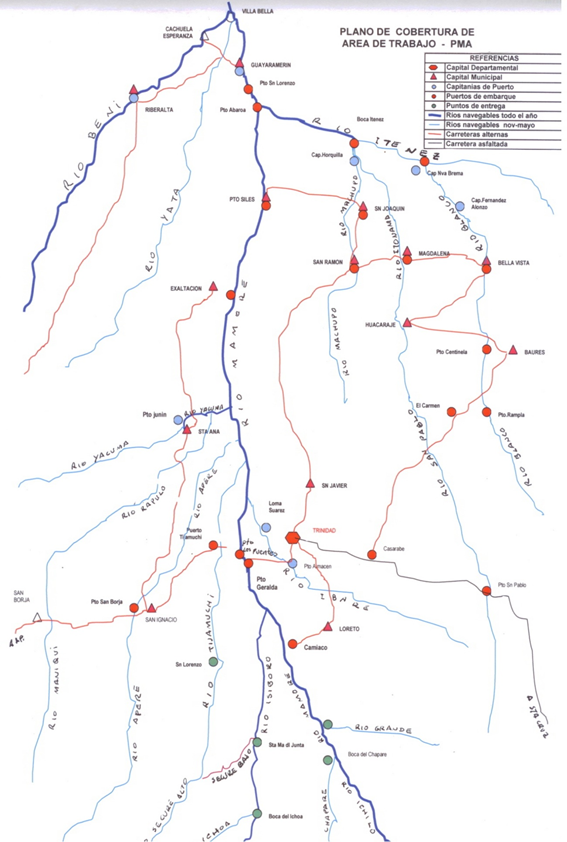
GLCSC LCA BOLIVIA Matriz Costo Transporte Fluvial 140930
For information on Bolivia waterways contact details, please see the following link:
4.4 Bolivia Port and Waterways Company Contact List
River Network System in the North West
The river network in this region is formed by rivers that connect with important populations in the area and international bonding points. The navigable rivers in the river network reach lengths close to 5,000 km, consisting of the following sections:
- Ríos Ichilo, Mamoré and Tributarios 2.023 Kms.
- Ríos Beni, Madre de Dios, Orthon and Tributarios 2.688 Kms
- TOTAL 4.711 Km
The corridor formed by the Ichilo - Mamore - Itenez rivers enables the connection of the northern region of the country with the highway system through Puerto Villarroel in Cochabamba. Among the important towns connected there are:
- Trinidad, capital of departamento of Beni
- Guayaramerín, border town located at the northern end of the department of Beni.
Both towns are important centers of production in the region where there is a significant flow of goods and people.
The river system Beni - Madre de Dios - Orthon (West of the Mamoré River) helps to connect the city of Riberalta (Northern part of Beni Department) with the highway system in Rurrenabaque (La Paz).
System of Paraguay River
The Paraguay River represents a very important connection for the foreign trade of the eastern region of the country, mainly by the large volumes of agricultural products. This system allows the connection with the ports of the Atlantic (Buenos Aires, Rosario, Nueva Palmira). It has an approximate length of 2771 Km.
This system, which is shared by five countries — Bolivia, Brazil, Paraguay, Argentina and Uruguay, has acquired significance for Bolivia at the beginning of the 1990s, due to the demand for larger volumes of cargo to be exported.
Access to this river today is via the Tamengo channel implying restrictions on permanent navigation, as well as the situation of dependency which means traversing a section which is located in Brazilian territory.
A solution to these disadvantage would be the construction of Puerto Busch connecting it with the so-called Punta Man Cesped, which would give Bolivia access to the waters of the Paraguay River.
The waterway can be divided into 5 stages: i) from Cáceres to Corumbá/Puerto Aguirre (Puerto Aguirre is where Bolivia peeps to Paraguay River); ii) from Puerto Aguirre to the Apa River, which is the border between Brasil and Paraguay; iii) from Apa River to Asunción; iv) from Asunción to Santa Fe, and v) finally from Santa Fe to Nueva Palmira and later the Río de la Plata,
The waterway by sectors:
- Section Puerto Cáceres – Corumba 672 KM, Section CORUMBA – APA River 603 KM, Section Río APA – Asunción 537 KM
- Section Asunción – Santa Fe 1.040 KM, Section Santa Fe - Nueva Palmira Buenos Aires 590 KM, Total WATERWAT Length 3.442 KM
The majority of goods transported by HPP are commodities, i.e. grains, cereal, wood, etc..
The main goods transported: grains 31,5 %, cereal 18,2 %, wood 17,7 %, heavy loads 12,3 %, fertilizers 9,4 %, Liquid fuel 6,7 %, gas fuels%.
Bolivian Ports
Bolivia in the stretch of the Paraguay River owns the following ports: a) Central Aguirre, located at Tamengo7 channel at 2 Kms from Puerto Quijarro, b) Puerto Tamengo or Gravetal , c) Puerto Busch, in the Man Césped corridor, which is innactive and d) Puerto Suárez, at Cáceres Lagoon, abandoned due to waterlogging.
External Ports
Bolivia has Access to the following external ports: i) Puerto de Rosario in Argentina, ii) Puerto Casado and Villeta in Paraguay, and, iii) Puerto Montevideo in Uruguay.
Puerto de Rosario, en 1969 Bolivia is granted the use of this port and also a free area of 54.667 m2 with the right to explote a Free zone in this place, where Bolivia can assign its own customs agents to dispense trade in transit (Orias, 2000). However this port has been little used and Bolivia has not worked in maintenance, equipment and operation of the springs, as stipulated in the agreement with the Argentina. Today, at this point the Bolivian goods in transit are transferred to or from the wagons of the train that connects to Santa Cruz.
Puerto Casado and Villeta, in the Peace Treaty of 1938 between Bolivia and Paraguay settles that Paraguay guarantees free transit through its territory and especially in the areas of Puerto Casado, with the right for Bolivia to install its customs agencies and build reservoirs and warehouses in the area of the port, also Paraguay has awarded the Villeta port - 37 km from Asunción - warehouse and storage area for the Bolivian load in transit.
Puerto Montevideo, Bolivia has access to the use of free zones of Nueva Palmira and Colonia and others that could be in Uruguayan territory, for traffic, storage, handling and fractionation of goods and raw materials of Bolivian origin destined for Uruguay, as well as the free use of a warehouse in the port of Montevideo (see Orias, 2000).
Zona Franca Puerto Aguirre, the first Bolivina port with sovereign sea coast through the waterway Paraguay Paraná, allows Bolivian export and import activities to be competitive from and to the world markets. It connects by land with Santa Cruz and by paved road with the interior of Brazil (Campo Grande, San Pablo, Paranagua, etc.). The airports of Puerto Suárez (Bolivia) and Corumbá (Brasil), both are at 10 km. from the Free Zone of Puerto Aguirre; they offer air transport services for passengers and cargo with daily Jet airplane flights.
Port for Containers and General
Cargo:
- Crane with a capacity for 150 tons
- 4500 m2 of warehouses.
- 1,5 linear kms railway detour
- Parking lot for Containers.
Services:
- Export of containers 20 and 40 feet
- Import of containers 20 and 40 feet
- Reexpediciones to third countries.
- Reexpediciones to interior Free Zones
- Storage of goods
Port for Grains and Oil:
- Conic Silo with a capacity for 18500 tons.
- Horizontal Silo with a capacitay for 22000 tons.
- Integral Network with conveyor belts.
- Firefighting Network
- Unloading capacity of trucks 160 tons/hour (6 trucks).
- Unloading capacity of railroad wineries 200 tons/hour(5 wineries).
- Unloading capacity of railway tanks 150 m³/hour (4 tanks railway).
- Loading capacity of grain barges 450 tons/hour (6 barges per day).
- Loading capacity of oil barges 200 tons/hour (3 barges per day).
- 3 linear kms of rail turnouts.
- Road Access.
Services:
- Export of grain and soybean flour.
- Export of soybean and sunflower oil.
- Import of wheat.
Company Information
In the stretch, Ichilo - Mamore tributaries, there are unions of general freight transport, with special boats with flatbeds with maximum capacity of 4,000 quintals. The transport of passengers is not regulated, nor the carriage of liquids (fuels), whose fleet is comprised of private tanker vessels, with a capacity of approximately 40,000 liters. They do not transport passengers because of the danger that that represents.
In the Beni River - Madre de Dios - Orthon stretch and tributaries, there are no private transportation companies, since it is a non-regulated stretch, heavily influenced by the weather. Practically it is navigable only between the months of November to February. In low water period, transport of goods is done by land
|
Passenger Carrying Capacity |
|||
|---|---|---|---|
|
COMPANY A |
COMPANY B |
COMPANY C |
|
|
Number of Passenger Vessels < 20 pax |
Transport of passengers is not regulated |
||
Travel Time Matrix
|
TRINIDAD Port |
SANTA ANA Port |
EXALTACION Port |
GUAYARAMERIN Port |
|
|---|---|---|---|---|
|
TRINIDAD Port |
n/a |
3 days |
4.5 days |
8.5 days |
|
SANTA ANA Port |
4 days |
n/a |
1.5 days |
5.5 days |
|
EXALTACION Port |
6.0 days |
1.5 days |
n/a |
4.0 days |
|
GUAYARAMERIN Port |
10.0 days |
7.0 days |
5.0 days |
n/a |
NOTE: Travel Time changes depending if the journey is downstream or upstream
Key Routes
|
From: Trinidad To: Guayaramerin |
From: Puerto Aguirre (BO) To:Puerto Villeta (PY) |
|
|---|---|---|
|
Total Distance (km) |
1,100 km |
2,770 Km |
|
Width (m): Broadest Narrowest |
Highly variable, not regulated, modified by climatic seasonality. Between December and March, greater width and depth, so the meanders are lost and the route is more direct |
Very variable in the cannel of Puerto Aguirre (Bolivia) to Corumba (Brasil), with 100 meters wide, which in some sections due to its rocky bed morphology is reduced up to 45 meters. There is no dredging agreement in the Bolivian-Parguayan section. |
|
River Flow (m³ / second) |
11.649 |
2.700 |
|
Seasonal Affects |
Very marked mostly between May and November, where the draught is reduced arising from sandbanks and Palisades |
Very marked during the dry seasons, the draught is below 6 feet, making it impossible to transport large barges that can move up to 12,000 TM by convoy |
|
Maximum Weight and Size of Vessels |
Only barges with the following characteristics: Length = 30 to 60 mtr Beam = 10 a 12 mtr Strut= 3.5 a 4.5 mtr Draught min = 2.4 a 3.5 mtr Propulsion = 3x1000 a 3x1800 HP Crew = 8 to10 people |
Barges of timber with the following characteristics: Length = 40 mtr Width = 26 mtr Draught min = 1.2 mtr Propulsion = 1x400 HP |
|
Regular Traffic Passenger / Cargo |
Yes, with caution during the dry seasons and reduction of cargo transportation, with the alternative of doing so by road in a shorter time |
Yes, with caution during the dry seasons and noticeable decrease in transport of load, up to 60% |
|
Companies Operating Along the Route |
Unipersonal general cargo companies and fuel transportation unions. |
Private companies in export of grains and minerals of iron and manganese |
|
Security Concerns (Yes / No) |
There are no signs on the way |
Not in the Bolivian stretch and with little signs in the Paraguayan stretch |
|
Main Ports |
There are only load and unload areas, which do not have a load assistance team, nor storage areas |
Puerto Aguirre (Bolivia), with all loading services Puerto Villeta (Paraguay), with all loading and shipping services. |
Port Information
|
Aguirre Port |
Villeta Port |
|
|---|---|---|
|
Location |
Aguirre Port |
Villeta, 37 km de Asuncion Paraguay |
|
Contact Information |
Aduana Nacional de Bolivia - Customs |
Administración Nacional de Navegacion y Puertos/National Administration of Navigation and Ports- ANNP www-annp-gov-py |
|
Connections with other transport means (road/waterways/air) |
Train to Santa Cruz By land to Santa Cruz |
By River to Rosario Argentina and Rosario Argentina |
|
Storage Capacity (square meters and cubic meters) |
4,500 m2 |
20,000 m3 |
|
Handling Equipment |
A 150-ton crane |
3 cranes of 12 Tn each |
|
Customs Clearance Available (Yes / No) |
Yes |
Yes |
2.6 Bolivia Storage Assessment
Bolivia Storage Assessment
For information on Bolivia storage contact details, please see the following link:
4.6 Bolivia Storage and Milling Company Contact List
GLCSC LCA BOLIVIA Private Storage 140930
Commercial Storage
Access Capacity to Storage Facilities, for lease contract.
|
Location |
Owner |
Available for Rent |
Capacity mt / m² / m³ |
Type * |
Access ** |
Condition *** |
|---|---|---|---|---|---|---|
|
Potosi |
FCA S.A. |
Yes |
800 |
Concrete |
Flat |
Good |
|
Oruro |
FCA S.A. |
Yes |
1,200 |
Concrete |
Flat |
Good |
|
Cochabamba |
FCA S.A. |
Yes |
6,000 |
Concrete |
Flat |
Good |
|
Viacha La Paz |
FCA S.A. |
Yes |
1,350 |
Concrete |
Flat |
Good |
[1] Warehouse Type: Open storage, container, rub-hall, silo, concrete, other, unspecified
[2] Warehouse Access: Raised-siding, flat
[3] Warehouse condition: Appears intact, appears damaged, under construction/repair
Storage Used by Humanitarian Organizations
Generally, humanitarian organizations have small to medium-sized storage areas in the national territory, spaces where they handle supplies they have committed to serve their regular activities. When their inventories increase to respond to emergencies, whether for local purchases or imports, they look for storage spaces in municipalities, local governments or they temporarily rent regional spaces, when they directly manage their facilities, so they do not have extra spaces to share.
The concept of Voucher is being applied lately, so the affected family can directly pick up products from pre-determined trade institutions, and avoid costs of storage and warehouse management outside from the Service Center of the organizations.
As organizations demand can be satisfied by local market, there is no large storage spaces for strategic goods.
Public Sector Storage
The Government has created 2 institutions to ensure the stabilization of prices in the market in the country, by investing in infrastructure, storage and collection. Currently WFP has signed a Cooperation Agreement with the Government, where la Empresa de Apoyo a la Producción Agropecuaria EMAPA e Insumos Bolivia (the Bolivia Company's Support to the Public Agricultural Production and Supplies) is part of the national counterpart.
Foodstuffs stored strategically are corn in grain, flour, rice and oil, which at a critical time as in an emergency, humanitarian organizations could have access to the purchase of such products from EMAPA.
|
Location |
Ministry / Agency |
Use Possibility (Yes / No) |
Capacity mt / m² / m³ |
Type* |
Access** |
Condition*** |
|---|---|---|---|---|---|---|
|
Santa Cruz |
EMAPA |
No |
100,000 TM |
Silo |
Flat |
Good |
|
La Paz |
EMAPA |
Yes |
700 M2 |
Concrete |
Flat |
Good |
|
Oruro |
EMAPA |
Yes |
595 M2 |
Concrete |
Flat |
Good |
|
Potosi |
EMAPA |
Yes |
300 M2 |
Concrete |
Flat |
Good |
|
Cochabamba |
EMAPA |
Yes |
310 M2 |
Concrete |
Flat |
Good |
|
Beni |
EMAPA |
Yes |
150 M2 |
Concrete |
Flat |
Good |
|
Sucre |
EMAPA |
Yes |
286 M2 |
Concrete |
Flat |
Good |
|
Tarija |
EMAPA |
Yes |
204 M2 |
Concrete |
Flat |
Good |
|
La Paz |
Insumos Bolivia |
Yes |
500 M2 |
Concrete |
Flat |
Good |
|
Cochabamba |
Insumos Bolivia |
Yes |
300 M2 |
Concrete |
Flat |
Good |
|
Oruro |
Insumos Bolivia |
Yes |
300 M2 |
Concrete |
Flat |
Good |
|
Tarija |
Insumos Bolivia |
Yes |
200 M2 |
Concrete |
Flat |
Good |
|
Santa Cruz |
Insumos Bolivia |
Yes |
300 M2 |
Concrete |
Flat |
Good |
GLCSC LCA BOLIVIA Almacenes EMAPA 140930
Cold Chain
In the country the cold chain is not fully implemented; the companies that market pharmaceutical products and meat have cold chambers according to the capacity of their activity, with reduced infrastructure and little ability to offer surplus spaces to share or rent.
The best offers are vehicles deployed with refrigeration systems, for national and international transport systems. There is also a range of logistics operator companies which have areas with facilities for refrigerated containers.
In the public sector, only the Ministry of Health has adequate infrastructure with control of temperature for the storage of strategic medicine and to supply to Hospitals and Health Centers, where it does not share spaces due to sector policies.
GLCSC LCA BOLIVIA Cold Transporters 140930
*Cold Room Positive, Cold Room Negative, Refrigerator,
Freezer,
**Compression, Absorption, Solar, Other, unspecified
**Warehouse condition: Appears intact, appears damaged, under
construction/repair
2.7 Bolivia Milling Assessment
Bolivia Milling Assessment
For information on contact details, please see the following link:
4.6 Bolivia Storage and Milling Company Contact List
The milling capacity in the country is determined by the sum of the individual capacities of each company.
The largest milling companies are registered with the Association of Industrial Millers (ADIM), which brings together companies in La Paz, Cochabamba, Potosi, Sucre and Santa Cruz.
Milling Company Sociedad Industrial Molinera S.A. SIMSA
|
Company Name & Address |
Contact Names & Email |
Telephone & Fax |
|---|---|---|
|
SIMSA Av. Chacaltaya Nº 774 La Paz |
Henry Ruiz Position: General Manager Email: Henry@princesa.com.bo Web: http://www.princesa.com.bo
|
Phone: (591 2) 2281343 Fax: (591 2) 2281641 |
|
Summary of Role and Services: Commercial company dedicated to milling and food production |
||
|
Facilities |
||
|---|---|---|
|
Parking area inside compound m² |
800 M2 |
|
|
Drainage (Good / Fair / Poor / Non Existent) |
Good |
|
|
Fire Fighting Equipment (Yes / No) |
Yes |
|
|
Number of Ventilators |
4 |
Screened |
|
Electricity Load (KVA) |
450 Kw |
|
|
Backup Generator (Yes / No / KVA) |
Yes |
KVA |
|
Milling Equipment |
|||
|---|---|---|---|
|
Origin of Machinery |
Year of Mfg |
Year of Mfg |
Condition |
|
Switzerland |
1984 |
1985 |
Good |
|
German |
1984 |
1985 |
Good |
|
Maintenance |
|||
|---|---|---|---|
|
Duration (hours / week) |
Week |
Type of maintenance |
Constant, with skilled personnel |
|
Other Equipment or Machinery Installed |
||||
|---|---|---|---|---|
|
Type of Equipment |
Yes/No |
Number |
Owned |
Comments |
|
Fortification Feeder |
Yes |
2 |
SIMSA |
Permanent use |
|
Bag Cleaning Plant |
No |
n/a |
n/a |
n/a |
|
Moisture Tester |
Yes |
1 |
SIMSA |
Permanent use |
|
De-stoning Plant |
Yes |
2 |
SIMSA |
Permanent use |
|
Metal Extractor |
Yes |
4 |
SIMSA |
Permanent use |
|
Staffing |
|
|---|---|
|
Number of full time skilled workers |
10 |
|
Number of full time laborers |
38 |
|
Weighbridge |
||||
|---|---|---|---|---|
|
Number |
2 |
Max Capacity (mt) |
Length (m) |
Type |
|
Within Compound |
40 |
9 x 3 |
weighbridge |
|
|
Building |
|||
|---|---|---|---|
|
|
Length (m) |
Width (m) |
Height (m) |
|
Building – Wheat Mill |
By design, the infrastructure has wide spaces, where the milling machinery is installed |
n/a |
n/a |
|
Building – Maize Mill |
Corn flour is not produced |
n/a |
n/a |
|
Walls |
Coated brick |
||
|
Roof |
Zinc calamine |
||
|
Floor |
Concrete slab |
||
|
Conditions & Cleanliness |
||
|---|---|---|
|
|
Outside |
Inside |
|
Cracks in walls or roof (Yes / No) |
No |
No |
|
Signs of rodent activity (Yes / No) |
No |
No |
|
Signs of rodent activity (Yes / No) |
Yes |
No |
|
Damaged gutters/drains(Yes / No) |
Yes |
Yes |
|
Signs of moisture (Yes / No) |
No |
No |
|
Adjacent Vegetation(Yes / No) |
No |
No |
|
Cleanliness (Good / Poor) |
Good |
Good |
|
Pest Control |
|||||
|---|---|---|---|---|---|
|
Fumigation |
Yes |
Frequency |
Biweekly |
Contracted (Yes / No) |
Yes |
|
Spraying |
Yes |
Frequency |
Biweekly |
Contracted (Yes / No) |
Yes |
|
Rodenticides |
Yes |
Frequency |
Biweekly |
Contracted (Yes / No) |
Yes |
|
Rodent Trapping |
Yes |
Frequency |
Biweekly |
Contracted (Yes / No) |
Yes |
|
Security |
|
|---|---|
|
Security (Good / Poor) |
Good |
|
Compound (Fenced / Not Fenced) |
Fenced |
|
Other Comments |
n/a |
|
Access |
|||
|---|---|---|---|
|
Distance from main town (km) |
From La Paz city center to the plant in El Alto 14 Km |
||
|
Travel time if not located in town (hours) |
1.0 hour |
||
|
Road condition to Mill |
Asphalted |
||
|
Road limitation (if any) Maximum Width and Max. Tonnage |
There are no limitations, since the mill is connected to an avenue 14 meters wide, between the plant and the road to the Road Network La Paz – Oruro |
||
|
Rail connections (Yes / No) |
Yes
|
||
|
On the railway from |
El Alto |
to |
Oruro |
|
Other Comments: n/a |
|||
|
Max Capacity (mt) |
||
|---|---|---|
|
Commodities |
Max Capacity (mt) |
Monthly Activity (mt) |
|
Wheat |
20 TM per day |
600 TM |
|
Maize |
N/A |
N/A |
|
Storage Capacity |
||
|---|---|---|
|
Storage in Metric Tonnes |
Wheat – Covered (mt) |
Flour – Covered (mt) |
|
Within the Compound |
1.000 |
1.000 |
|
Within the Compound |
N/A |
N/A |
|
Capacity to Blend |
|---|
|
n/a |
|
Loading & Discharge Rates |
|---|
|
1.50 Bs/bolsa |
|
Transport Capacity at Mill |
|---|
|
20 TM/day |
Milling Company CIC HNOS. VICENTE S.R.L.
|
Company Name & Address |
Contact Names & Email |
Telephone & Fax |
|---|---|---|
|
Compañía Industrial Comercial Hermanos Vicente S.R.L. |
Jose E. Vicente Position: General Manager Email: jevicente@famosa.com.bo Web: www.famosa.com.bo
|
Phone: (591 3) 3345999 Fax: (591 3) 3329905 |
|
Summary of Role and Services: Industrial milling company |
||
|
Facilities |
||
|---|---|---|
|
Parking area inside compound m² |
400 m2 |
|
|
Drainage (Good / Fair / Poor / Non Existent) |
Good |
|
|
Fire Fighting Equipment (Yes / No) |
Yes |
|
|
Number of Ventilators |
n/a |
Screened |
|
Electricity Load (KVA) |
400 |
|
|
Backup Generator (Yes / No / KVA) |
No |
KVA |
|
Milling Equipment |
|||
|---|---|---|---|
|
Origin of Machinery |
Year of Mfg |
Year of Mfg |
Condition |
|
BUHLER |
1988 – 1992 - 2005 |
1988 – 1992 - 2005 |
Good |
|
Maintenance |
|||
|---|---|---|---|
|
Duration (hours / week) |
Week |
Type of maintenance |
Constant, as per internal regulation |
|
Other Equipment or Machinery Installed |
||||
|---|---|---|---|---|
|
Type of Equipment |
Yes/No |
Number |
Owned |
Comments |
|
Fortification Feeder |
Yes |
3 |
Vicente |
n/a |
|
Bag Cleaning Plant |
No |
n/a |
n/a |
New bags are used |
|
Moisture Tester |
Yes |
1 |
Vicente |
n/a |
|
De-stoning Plant |
Yes |
3 |
Vicente |
n/a |
|
Metal Extractor |
Yes |
6 |
Vicente |
n/a |
|
Staffing |
|
|---|---|
|
Number of full time skilled workers |
147 |
|
Number of full time laborers |
100 |
|
Weighbridge |
||||
|---|---|---|---|---|
|
Number |
2 |
Max Capacity (mt) |
Length (m) |
Type |
|
Within Compound |
60 |
15 x 3 |
Digital weighbridge |
|
|
Building |
|||
|---|---|---|---|
|
|
Length (m) |
Width (m) |
Height (m) |
|
Building – Wheat Mill |
As an industrial complex, the surfaces of the facilities are variable with large spaces for the machinery |
n/a |
n/a |
|
Building – Maize Mill |
Corn flour is not produced |
n/a |
n/a |
|
Walls |
Coated brick |
||
|
Roof |
Zinc calamine |
||
|
Floor |
Concrete slab |
||
|
Conditions & Cleanliness |
||
|---|---|---|
|
|
Outside |
Inside |
|
Cracks in walls or roof (Yes / No) |
No |
No |
|
Signs of rodent activity (Yes / No) |
No |
No |
|
Signs of rodent activity (Yes / No) |
No |
No |
|
Damaged gutters/drains(Yes / No) |
Yes |
Yes |
|
Signs of moisture (Yes / No) |
No |
No |
|
Adjacent Vegetation(Yes / No) |
No |
No |
|
Cleanliness (Good / Poor) |
Good |
Good |
|
Pest Control |
|||||
|---|---|---|---|---|---|
|
Fumigation |
Yes |
Frequency |
periodic |
Contracted (Yes / No) |
Yes |
|
Spraying |
Yes |
Frequency |
periodic |
Contracted (Yes / No) |
Yes |
|
Rodenticides |
Yes |
Frequency |
periodic |
Contracted (Yes / No) |
Yes |
|
Rodent Trapping |
Yes |
Frequency |
periodic |
Contracted (Yes / No) |
Yes |
|
Security |
|
|---|---|
|
Security (Good / Poor) |
Good |
|
Compound (Fenced / Not Fenced) |
Fenced |
|
Other Comments |
n/a |
|
Access |
|||
|---|---|---|---|
|
Distance from main town (km) |
In the urban area - Industrial Park Santa Cruz |
||
|
Travel time if not located in town (hours) |
N/A |
||
|
Road condition to Mill |
Urban asphalted avenues and streets |
||
|
Road limitation (if any) Maximum Width and Max. Tonnage |
N/A |
||
|
Rail connections (Yes / No) |
No |
||
|
On the railway from |
n/a |
to |
n/a |
|
Other Comments n/a |
|||
|
Max Capacity (mt) |
||
|---|---|---|
|
Commodities |
Max Capacity (mt) |
Monthly Activity (mt) |
|
Wheat |
300 TM/day |
3,500 to 5,000 TM |
|
Maize |
n/a |
n/a |
|
Storage Capacity |
||
|---|---|---|
|
Storage in Metric Tonnes |
Wheat – Covered (mt) |
Flour – Covered (mt) |
|
Within the Compound |
60,000 TM |
60,000 TM |
|
Within the Compound |
N/A |
N/A |
|
Capacity to Blend |
|---|
|
N/A |
|
Loading & Discharge Rates |
|---|
|
2.0 Bs/bag |