Iran, Islamic Republic of - 2.3 Road Network
Iran Road Maintenance & Transportation Organization, under the supervision of the Ministry of Roads and Urban Development of Iran, is responsible for the construction, maintenance, and development of Iran's roads and also for developing the rules and regulations related to road transportation either for domestic movements or international transits. This organization also issues the work licences for Iranian road transporters and movement licences for international transporters. This organisation is also responsible for implementing the international road conventions such as TIR Carnet and CMR.
For more information on government contact details, please see the following link: 4.1 Government Contact List.
Distance Matrix
|
Distances from Capital City to Major Towns (km) |
||||||||
|---|---|---|---|---|---|---|---|---|
|
Tehran |
Bandar Abbas |
Bandar Anzali |
Bandar Imam |
Bazargan |
Taybad |
Piranshahr |
Milak |
|
|
Tehran |
1,276 |
364 |
907 |
902 |
1000 |
754 |
1,547 |
|
|
Bandar Abbas |
1,276 |
1,609 |
1,032 |
2,081 |
1,362 |
1,901 |
1,002 |
|
|
Bandar Anzali |
364 |
1,609 |
1,153 |
801 |
1,444 |
591 |
1,874 |
|
|
Bandar Imam |
907 |
1,032 |
1,153 |
1,536 |
1,639 |
1,182 |
1,639 |
|
|
Bazargan |
902 |
2,081 |
801 |
1,536 |
1,980 |
438 |
2,411 |
|
|
Taybad (Dogharoun BorderPoint to Afghanistan) |
1000 |
1,362 |
1,444 |
1,639 |
1,980 |
1,825 |
720 |
|
|
Piranshahr (Bashmagh border point To Iraq) |
754 |
1,901 |
591 |
1,182 |
438 |
1,825 |
2,278 |
|
|
Milak (Afghanistan Border) |
1,547 |
1,002 |
1,874 |
1,639 |
2,411 |
720 |
2,278 |
|
|
Travel Time from Capital City to Major Towns (hr) |
||||||||
|---|---|---|---|---|---|---|---|---|
|
Tehran |
Bandar Abbas |
Bandar Anzali |
Bandar Imam |
Bazargan |
Taybad |
Piranshahr |
Milak |
|
|
Tehran |
14.4 |
5 |
11.15 |
10.5 |
21.2 |
10 |
18 |
|
|
Bandar Abbas |
14.4 |
18.3 |
13.19 |
24 |
15.3 |
23 |
13 |
|
|
Bandar Anzali |
5 |
18.3 |
14 |
10.45 |
16.48 |
9.42 |
23.43 |
|
|
Bandar Imam |
11.15 |
13.19 |
14 |
19.1 |
21 |
16.2 |
21.3 |
|
|
Bazargan |
10.5 |
24 |
10.45 |
19.1 |
22 |
6.1 |
27 |
|
|
Taybad (Dogharoun BorderPoint to Afghanistan) |
21.2 |
15.3 |
16.48 |
21 |
22 |
22.18 |
9.35 |
|
|
Piranshahr (Bashmagh border point To Iraq) |
10 |
23 |
9.42 |
16.2 |
6.1 |
22.18 |
27 |
|
|
Milak (Afghanistan Border) |
18 |
13 |
23.43 |
21.3 |
27 |
9.35 |
27 |
|
Road Security
The road condition and security are at good level. The roads are maintained and supervised by the Ministry of Road and Transportation. There are speed control cameras set up on roads especially on the highways. The traffic police officers patrolling 24/7. There are security check points on the roads between most cities and villages.
Weighbridges and Axle Load Limits
|
Axle load limits |
LCA Country |
|---|---|
|
Truck with 2 axles |
18 mt |
|
Truck with 3 axles |
26 mt |
|
Truck with 4 axles |
34 mt |
|
Semi-trailer with 3 axles |
26 mt |
|
Semi-trailer with 4 axles |
32 mt |
|
Semi-trailer with 5 axles |
36 mt |
|
Semi-trailer with 6 axles |
40 mt |
|
Truck & drawbar trailer with 4 axles |
18 mt |
|
Truck & drawbar trailer with 5 axles |
18 mt |
|
Truck & drawbar trailer with 6 axles |
18 mt |
|
Truck & drawbar trailer with 7 axles |
18 mt |
The movement of vehicles whose dimensions and weights, without load, or after loading the cargo, exceed at least one of the following dimensions or weights, are subject to the provisions of the heavy load traffic instruction, and for their movement, a pass must be issued. Such vehicles are referred as traffic vehicles and their consignments will be considered as traffic consignments, and companies that have the necessary licenses for undertaking the transportation of such consignments are called traffic transport companies.
1- Width: 60/2 meters (two meters sixty centimeters)
2- Height: 50/4 meters (four and a half meters)
3- Length:
Two-axle truck 10 meters (ten meters)
Truck with a towbar of 12 meters (twelve meters)
-axle trailer with more than 16/50 meters (sixteen and a half meters)
4- Weight: 40 tons
Note: In some country’s roads, due to existing obstacles, the height restrictions might be less than 4.50 meters, in such cases the movement of vehicles with a height of less than 4.50 meters in the above axes are also subject to the provisions of this instruction.
Note: The maximum amount of cargo back protrusion from the centre of the last axis of the vehicle, in trucks, is 3 meters, and in trailers, 5 meters, the maximum amount of cargo side protrusion from the centre of the first axis of the vehicle is 1.50 meters. Under any circumstances, vehicles with a side protrusion or back protrusion of more than the above values are not allowed to travel on the roads of the country.
International transporters, which move traffic cargo, if they do not have a heavy traffic transport license, are obliged to transport the cargo in the territory of Iran in cooperation with a local traffic transport company that has the necessary license. In this case, an internal bill of lading is not required.
Traffic companies are required to check the transit route and existing weight and height restrictions, as well as the latest changes made to this instruction, and the weight and height restrictions, which are available on the website, before issuing a transit permit for the movement of traffic cargo. The transportation organization and terminals of the country will be updated, or through the general administrations, and the transportation organizations of the provincial terminals will be announced.
Permitted hours for traffic vehicles are from half an hour after sunrise to half an hour before sunset. Therefore, traffic transport companies should adjust the travel schedule of vehicles, with the exact time of departure, in different parts of the country, as well as in different months of the year, so that they stop at the right times and at specific stops. In the direction specified for movement.
Traffic companies can operate in cities where traffic is restricted during the day, or in villages where the movement of vehicles is dangerous due to crossing bridges, or the like, during the night, between 12 noon and midnight. 5 in the morning, cross the area.
Road Class and Surface Conditions
Iran has a total area of 1,648,195 km2 including 30 provinces. All provinces, capital and main cities, villages and urban areas are connected via roads. Iran roads are also connected to international roads via different borders at north, west and east of country. As per Iran Road Maintenance and Transportation Organization’s statistical yearbook, the total length of Iran’s road network excluding rural roads is 85,934 km in total, as elaborated below.
|
Road Type |
Freeway |
Highway |
Main Roads |
Arterial Roads |
Tranzit Roads |
Rural Roads |
|---|---|---|---|---|---|---|
|
Length (Km) |
2,813 |
20.312 |
26,012 |
34,633 |
25,329 |
134,243 |
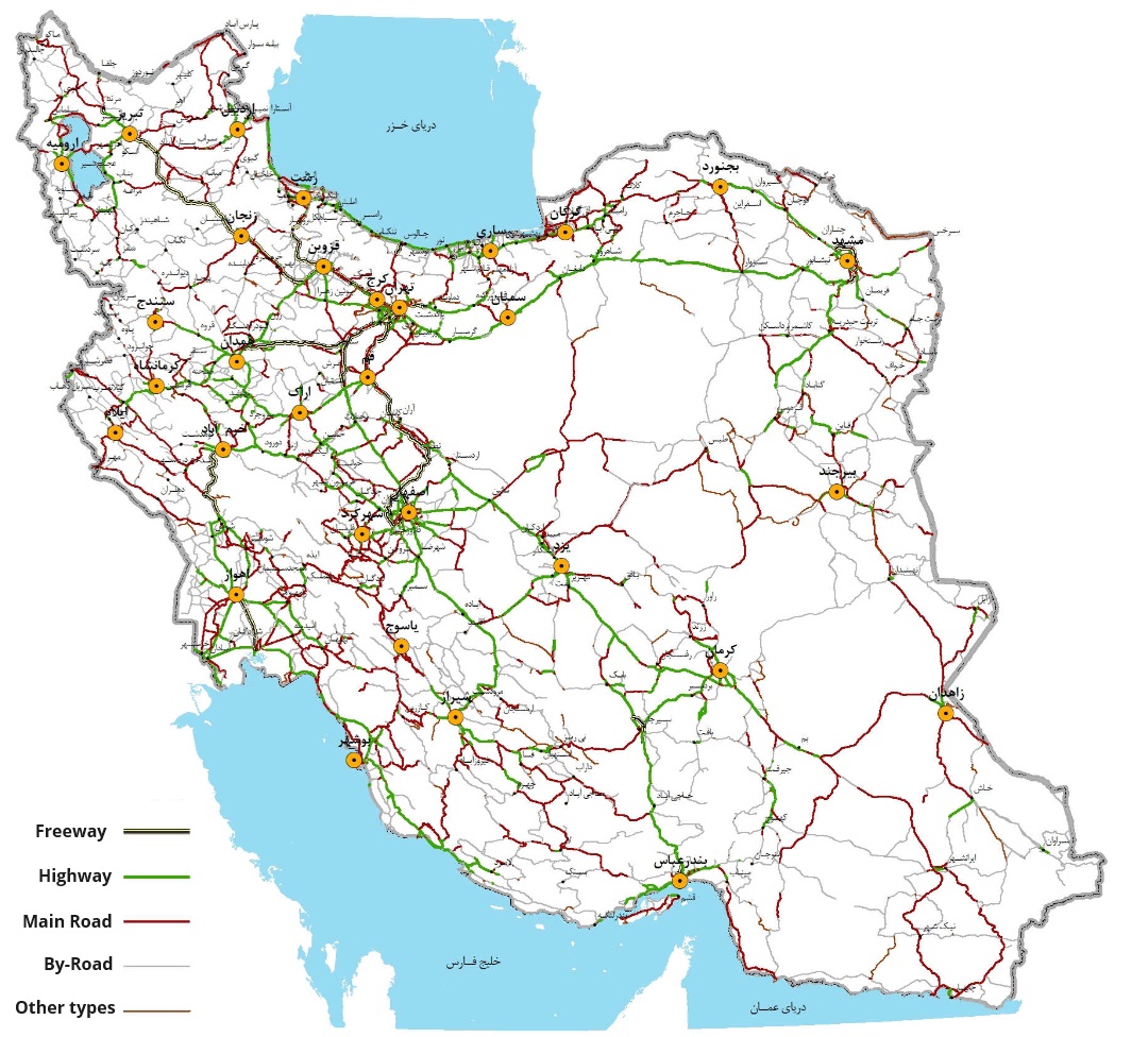
All freeways and highways are asphalted and surfaces are in good condition. Road marking and guard rails are under maintenance and supervision of Ministry of Roads & Construction. Other main roads are also asphalted, marking and guardrails are in good conditions as well as routine maintenances of surface and accessories. All roads are under control of Traffic Police and security wise are under control of Security Police Force.
In all highways, main roads and freeways the rules of speed control is under supervision of traffic police and all highways and freeways are equipped with speed-cameras. All trucks, transit trailers are equipped to GPS so that it is possible for traffic police to control location and speed of transit trucks.
Moreover, Iran has 391 tunnels with 221km length and 332,000 bridges with 1,063 toll stations.
Iran, Islamic Republic of - 2.3.1 Border Crossing of Bazargan
Overview
Iran has common borders with seven countries including Turkmenistan, Iraq, Pakistan, Turkey, Afghanistan, Armenia, Azerbaijan.
Iran's land border crossings are crucial entry and exit points for goods and travelers, facilitating international trade and regional connectivity. These crossings are equipped with various facilities to support customs, immigration, and transportation services. Common facilities include customs inspection areas, immigration checkpoints, cargo terminals, parking facilities, and administrative offices. Additionally, some crossings may have amenities such as rest areas, restaurants, and currency exchange services to cater to travelers' needs.
However, crossing Iran's land borders can pose challenges and obstacles for travelers and traders. Common issues include long wait times due to congestion, bureaucratic procedures, and security checks. Delays in processing paperwork and cargo inspections can also occur, leading to disruptions in trade flows and travel schedules. Moreover, language barriers and cultural differences may complicate interactions with border officials, particularly for international travelers.
|
Border Crossing Location and Contact |
|
|---|---|
|
Name of Border Crossing |
Iran: Bazargan Turkey: Gurbulak |
|
Province or District |
East Azarbaijan Province |
|
Nearest Town or City with Distance from Border Crossing |
Bazargan City 1km |
|
Latitude |
39.0369° N |
|
Longitude |
44.5136° E |
|
Managing Authority / Agency |
Boarder Guard Command (FARAJA) |
|
Contact Person |
|
|
Travel Times |
|
|---|---|
|
Nearest International Airport |
Tabriz International Airport 270 km Truck Travel Time: 5-6 hrs Car Travel time: 4 hrs |
|
Nearest Port |
Bandar-e Anzali Port 670 km Truck Travel Time: 12-14hrs Car Travel time: 10-11 hrs |
|
Nearest location with functioning wholesale markets, or with significant manufacturing or production capacity |
Tabriz City 278 km Truck Travel Time: 5-6 hrs Car Travel time: 4 hrs |
|
Other Information
|
Petrol station is available throughout the road path. |
Customs Clearance
For more information on customs, please see the following link: 1.3 Customs Information.
Other Relevant Information
For more information on government contact details, please see the following link: 4.1 Government Contact List.
Iran, Islamic Republic of - 2.3.2 Border Crossing of Bilasuvar
Overview
Bileh savar border crossing is in northeastern Ardabil province. This county is bordered by the Republic of Azerbaijan to the east, northeast, and southeast, with approximately 68 kilometers of common border. The center of this county is the city of Bileh Savar, and its climate is warm in summer and moderate in other seasons. Due to its proximity to the Caspian Sea and low altitude, it falls into the category of semi-humid regions.
The joint market between Bileh Savar Iran and Azerbaijan is semi-closed, but the customs market is active in three phases and attracts thousands of people from different areas to this country for trade every day. The main goods offered in this market are women's clothing, men's suits, and cosmetics and hygiene products.
|
Border Crossing Location and Contact |
|
|---|---|
|
Name of Border Crossing |
Iran: Bileh Savar Azerbaijan: Bilasuvar |
|
Province or District |
Ardabil Province |
|
Nearest Town or City with Distance from Border Crossing |
Bileh Savar City 1km |
|
Latitude |
39.38968° N |
|
Longitude |
48.36145° E |
|
Managing Authority / Agency |
Boarder Guard Command (FARAJA) |
|
Contact Person |
|
|
Travel Times |
|
|---|---|
|
Nearest International Airport |
Ardabil International Airport 177 km Truck Travel Time: 3-4 hrs Car Travel time: 2 hrs |
|
Nearest Port |
Bandar-e Anzali Port 297 km Truck Travel Time: 7-9 hrs Car Travel time: 5-6 hrs |
|
Nearest location with functioning wholesale markets, or with significant manufacturing or production capacity |
Ardabil City 169 km Truck Travel Time: 4-5 hrs Car Travel time: 3 hrs |
|
Other Information
|
|
Customs Clearance
For more information on customs, please see the following link: 1.3 Customs Information.
Other Relevant Information
For more information on government contact details, please see the following link: 4.1 Government Contact List.
Iran, Islamic Republic of - 2.3.3 Border Crossing of Dogharoun
Overview
Dogharoun Land Border Crossing is a significant international border crossing situated in the Khorasan Razavi Province of Iran, near the city of Taybad. It serves as a crucial link between Iran and Afghanistan, facilitating the movement of goods, people, and vehicles between the two countries. The border crossing plays a vital role in promoting trade, transportation, and cultural exchange between Iran and Afghanistan, contributing to regional connectivity and economic development. As an essential point of entry and exit, Dogharoun Land Border Crossing is equipped with customs, immigration, and security facilities to manage the flow of traffic effectively.
|
Border Crossing Location and Contact |
|
|---|---|
|
Name of Border Crossing |
Dogharoun |
|
Province or District |
Khorasan Razavi Province |
|
Nearest Town or City with Distance from Border Crossing |
Taybad City 6km |
|
Latitude |
34.4845° N |
|
Longitude |
60.3173° E |
|
Managing Authority / Agency |
Boarder Guard Command (FARAJA) |
|
Contact Person |
|
|
Travel Times |
|
|---|---|
|
Nearest International Airport |
Mashhad International Airport 271 km Truck Travel Time: 6-8 hrs Car Travel time: 3.5-4 hrs |
|
Nearest Port |
Chabahar Port 1440 km Truck Travel Time: 18-20hrs Car Travel time: 24-28 hrs |
|
Nearest location with functioning wholesale markets, or with significant manufacturing or production capacity |
Mashhdad City 270 km Truck Travel Time:5-6 hrs Car Travel time:3.5-4 hrs |
Customs Clearance
For more information on customs, please see the following link: 1.3 Customs Information.
Other Relevant Information
For more information on government contact details, please see the following link: 4.1 Government Contact List.
Iran, Islamic Republic of - 2.3.4 Border Crossing of Parviz Khan
Overview
Parviz Khan Border Crossing is one of the western border crossings of Iran with Iraq, located in the Qasr-e Shirin County in Kermanshah Province. It facilitates Iran's connection with the Kurdistan Region of Iraq. Iranian travelers and tourists can travel with their private vehicles from Parviz Khan Border Crossing in this county to various cities in the Kurdistan Region of Iraq. Parviz Khan Border Crossing Market is one of the economic hubs of the country, established and launched in 1997. Initially, its area was three hectares, but it has now expanded to 30 hectares and with the ongoing plans of the provincial authorities, the area of Parviz Khan Border Crossing Market is expected to increase to 400 hectares in the future.
|
Border Crossing Location and Contact |
|
|---|---|
|
Name of Border Crossing |
Parviz Khan |
|
Province or District |
Kermanshah Province |
|
Nearest Town or City with Distance from Border Crossing |
Qasr-e Shirin City 5km |
|
Latitude |
36.6754° N |
|
Longitude |
45.0759° E |
|
Managing Authority / Agency |
Boarder Guard Command (FARAJA) |
|
Contact Person |
|
|
Travel Times |
|
|---|---|
|
Nearest International Airport |
Kermanshah Airport 170 km Truck Travel Time: 3-5 hrs Car Travel time: 2.5-3 hrs |
|
Nearest Port |
Imam Khomeini Port 717 km Truck Travel Time: 12-14hrs Car Travel time: 8-10 hrs |
|
Nearest location with functioning wholesale markets, or with significant manufacturing or production capacity |
Kermanshah City 170 km Truck Travel Time:4-5 hrs Car Travel time:2-3 hrs |
Customs Clearance
For more information on customs, please see the following link: 1.3 Customs Information.
Other Relevant Information
For more information on government contact details, please see the following link: 4.1 Government Contact List.
Iran, Islamic Republic of - 2.3.5 Border Crossing of Mirjaveh
Overview
Mirjaveh Border Crossing, also known as Mile 72 Border Crossing, is the most important border crossing between Iran and Pakistan, located 12 kilometers from the city of Mirjaveh and adjacent to the town of Taftan in Pakistan, and 89 kilometers southeast of Zahedan. This border crossing connects Iran to Pakistan and the Indian subcontinent via railway. It is also the junction of Iran's Road 84 and Pakistan's N-40 highway. In Pakistan, this border is known as the Taftan Border.
|
Border Crossing Location and Contact |
|
|---|---|
|
Name of Border Crossing |
Mirjaveh |
|
Province or District |
Sistan and Baluchestan Province |
|
Nearest Town or City with Distance from Border Crossing |
Mirjaveh City 2km |
|
Latitude |
29.0121° N |
|
Longitude |
61.4607° E |
|
Managing Authority / Agency |
Boarder Guard Command (FARAJA) |
|
Contact Person |
|
|
Travel Times |
|
|---|---|
|
Nearest International Airport |
Zahedan International Airport 82 km Truck Travel Time: 2-3 hrs Car Travel time: 1.5-2 hrs |
|
Nearest Port |
Chabahar Port 735 km Truck Travel Time: 10-12hrs Car Travel time: 7-8 hrs |
|
Nearest location with functioning wholesale markets, or with significant manufacturing or production capacity |
Zahedan City 82 km Truck Travel Time:2-3 hrs Car Travel time: 1.5-2 hrs |
Customs Clearance
For more information on customs, please see the following link: 1.3 Customs Information.
Other Relevant Information
For more information on government contact details, please see the following link: 4.1 Government Contact List.
Iran, Islamic Republic of - 2.3.6 Border Crossing of Milak
Overview
The Milak Border Terminal, established in 2005 on a 12.5-hectare site, aims to facilitate passenger and transit cargo transport in southeastern Iran and promote regional, political, economic, social, and cultural development. The terminal's marketplace facilitates the export of various goods from Iran to Afghanistan, including food items, plastic products, machine-made carpets, cement, clothing, and hygiene products.
Additionally, the Silk Bridge was constructed adjacent to the Milak marketplace, with plans underway to launch a second bridge. The Silk Bridge serves as the primary link between Zaranj, Afghanistan, and the Milak border in Iran, with half of the bridge's territory belonging to Iran and the other half to Afghanistan.
|
Border Crossing Location and Contact |
|
|---|---|
|
Name of Border Crossing |
Milak |
|
Province or District |
Sistan and Baluchestan Province |
|
Nearest Town or City with Distance from Border Crossing |
Zabol City 40km |
|
Latitude |
29.6255° N |
|
Longitude |
61.2401° E |
|
Managing Authority / Agency |
Boarder Guard Command (FARAJA) |
|
Contact Person |
|
|
Travel Times |
|
|---|---|
|
Nearest International Airport |
Zahedan International Airport 260 km Truck Travel Time: 5-6 hrs Car Travel time: 2.5-3 hrs |
|
Nearest Port |
Chabahar Port 893 km Truck Travel Time: 11-13hrs Car Travel time: 9-10 hrs |
|
Nearest location with functioning wholesale markets, or with significant manufacturing or production capacity |
Zahedan City 255 km Truck Travel Time:5-7 hrs Car Travel time: 3-4 hrs |
Customs Clearance
For more information on customs, please see the following link: 1.3 Customs Information.
Other Relevant Information
For more information on government contact details, please see the following link: 4.1 Government Contact List.