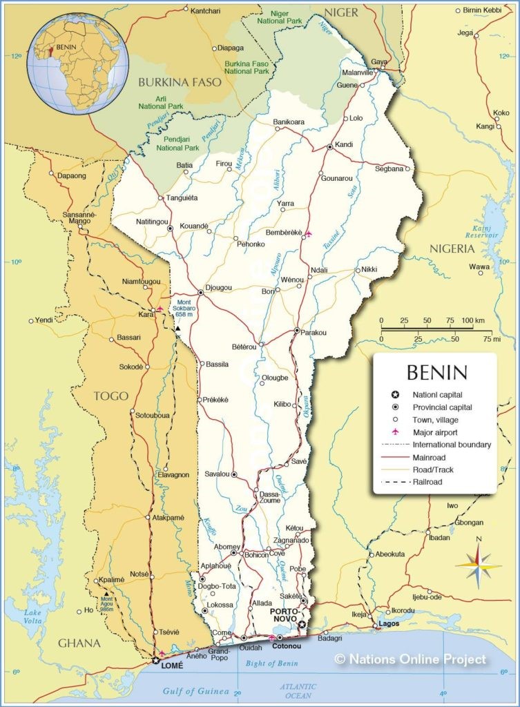
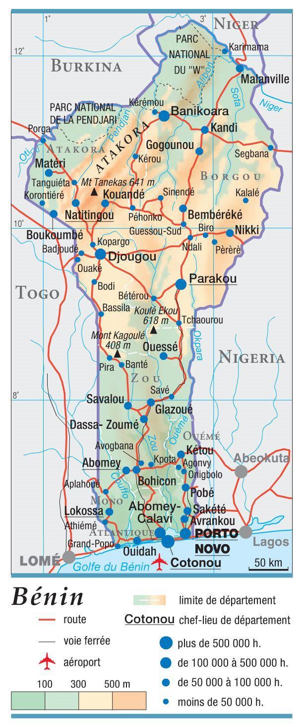
Benin - 2.3 Road Network
Road Network
|
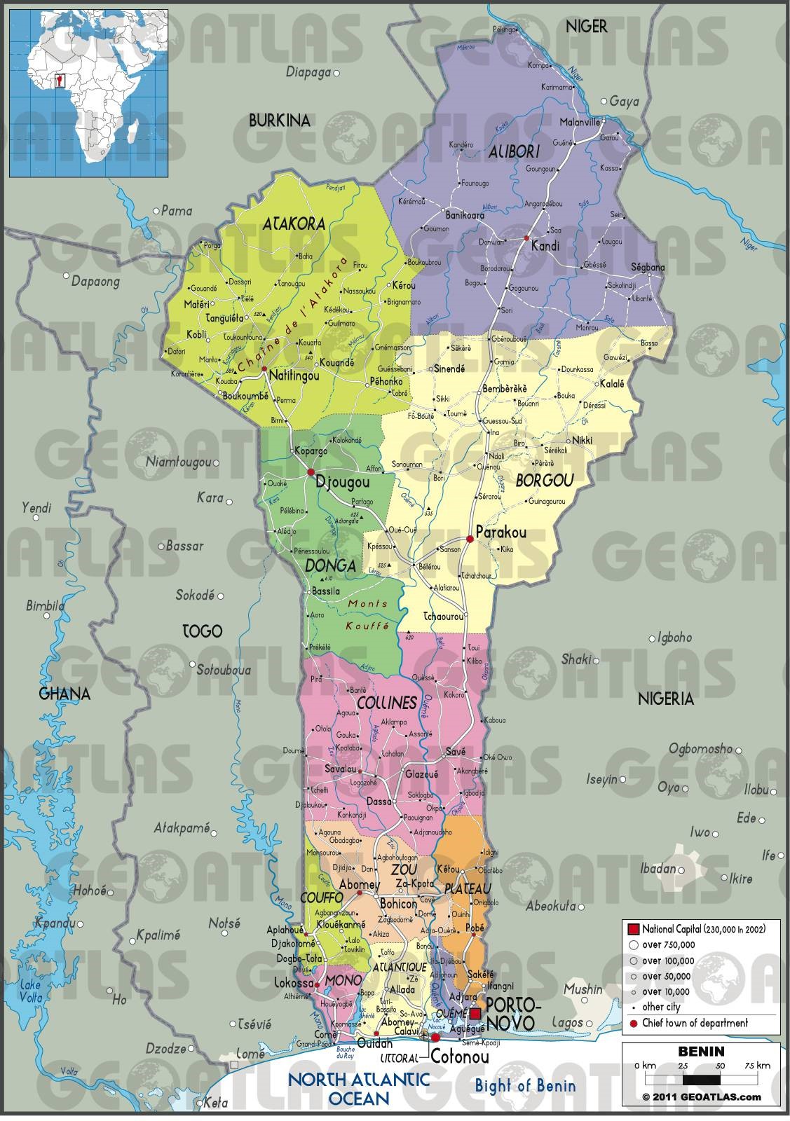
https://www.actualitix.com/carte-benin.html#routiere Lien List of the national road (Routes nationales) in Benin As the information indicated by the Ministry of transports officials, Benin National roads network represent about 16,000 km inventoried in the country. The Road is the main mode of transport inside the country. The transport department indicated that it could be about 10% to 11% increase per year of traffic on asphalted roads and about 6% to 7% on non-asphalted roads over the last 15 years (2003 -2018). About 11.25% of the primary roads in Benin are asphalted or paved. The paved stretch can be mostly found in the southern region (Zou, Littoral and Plateau) and the principal towns. The Secondary roads make up around 33% and consist of lateral and gravel roads. The roads network remained in poor condition despites some of them are under long plans of construction. There are different projects that the government intends to launch with the support of development partners. Benin’s geographical position makes it as a main corridor to other West African countries (including Niger and Burkina Faso).
The General Directorate of Land Transport is a technical structure of the Ministry of Public Works and Transport. In this capacity, she is responsible for the regulation of road and rail transport, the issuance and control of travel documents, transport authorizations and the coordination of road freight. Today, there is no doubt that the transportation sub-sector plays a significant strategic role in Benin national economy. It is then essential to follow its evolution, to analyse its performance in order to appreciate its efficiency and the quality of its service. The road projects contain a portfolio of 29 priorities of rehabilitations, Asphalts, estimated at 1.6 billion Euros (US $1.8 billion, FCFA 3.202 trillion). That includes some rehabilitations, modernizations and extensions of the national roads network for the period of 2016-2021, and Constructions of Hilaconji / Sanvéecondji Juxtaposed Control Stations for the period of 2016-2018, with a total cost of 19,946 million FCFA. Link
During the rainy season from mid-September to mid-November, muddy roads often become impassable. Transporters are faced to deploy accommodated lighter trucks with 4-wheels drive. Full spare tires and other useful safety equipments are required. Most of the rural roads require other types of lighter vehicles (Moto tricycles and 2-wheels, are often used. However, the old bridges on the rivers are in places, the crossings of these rivers become almost impassable. Roads cut, or flooding is frequent, and the canoes are used to reach the villages along the rivers. On the primary roads, the toll gates fees are applied and vary progressively from 150 XOF to 500 XOF.
Distance MatrixDistances from Capital City to Major Towns (km)
Travel Time from Capital City to Major Towns (km)
Road SecurityIn general, Benin roads are in bad condition. The road security was poor in the past few years due to the road conditions and absence of proper regulations of road safety implementation. Therefore, thieves (Bandits) were operating on primary roads connecting the principal towns to the land borders. Recently, the government took an excellent initiative to improve the roads security and safety by deploying the mobile police to different levels. The vehicle conditions, speeds limits and inspections are not respected in the country. Most of the drivers are driving without a minimum knowledge of road regulations, bad condition of vehicles no lights during the night and the overloading of trucks are all factors that impact the road security level in the country. In some regions, armed robberies might occur on certain roads. It is advisable not to travel during the night. Weighbridges and Axle Load LimitsIn Benin, there are Four (4) weighbridges at the Port Autonomous of Cotonou, installed at the trucks exit gates and the terminals for good exportations according to the standard norms of Verify Gross Mass (VGM). Despite this disposition in place, there are no real regulations on axle load limits in the Country. The remarks focused that the overloaded trucks accelerate the deterioration of the new roads constructed.
Road Class and Surface Conditions
|
|||||||||||||||||||||||||||||||||||||||||||||||||||||||||||||||||||||||||||||||||||||||||||||||||||||||||||||||||||||||||||||||||||||||||||||||||||||||||||||||||||||||||||||||||||||||||||||||||||||||||||||||||||||||||||
Benin - 2.3.1 Niger Malanville Border Crossing
Land Border Crossing Overview:
Located in the northeast of Benin, 732.4 km from Cotonou and within reach after a 12-hours’ drive via the RNIE2, the commune of Malanville extends over an area of 3016 km2. Its natural border is the Niger River and connected to the Republic of Niger by the Sota bridge, rebuilt by the Government of President Patrice TALON following its subsidence. Malanville is subdivided into 5 districts: Garou, Guéné, Madécali, Malanville and Tomboutou.
|
BORDER CROSSING LOCATION & CONTACT |
|
|---|---|
|
Name of Border Crossing: |
Juxtaposed Customs Post of Malanville |
|
Province or District: |
Malanville |
|
Nearest Town or City: (Nearest location with distance from port) |
Gaya (Niger) 10 km |
|
Latitude: |
|
|
Longitude: |
3° 23′ 00″ E |
|
Managing Authority/Agency: |
Benin/Niger Customs Authority |
|
Contact Person |
|
|
Travel Times |
|
|---|---|
|
Nearest International Airport: |
Cotonou International Airport 732.4 Km Truck: 2 days Car: 1 day |
|
Nearest Port: |
Cotonou Autonomous Port 732.4 Km Truck: 2 days Car: 1 day |
|
Nearest Major Market: (Nearest location with functioning wholesale markets, or with significant manufacturing or production capacity.) |
Malanville and Parakou Town Markets 0 and 320 Km Truck: 1 full day Car: 12 hours |
|
Other Information:
|
The weighing bridge is in Juxtaposed zone at the customs post. There is a bridge to cross River Niger. |
|
Hours of Operation |
|
|---|---|
|
MONDAYS |
24/24 Hours (7/7 Days) |
|
TUESDAYS |
24/24 Hours (7/7 Days) |
|
WEDNESDAYS |
24/24 Hours (7/7 Days) |
|
THURSDAYS |
24/24 Hours (7/7 Days) |
|
FRIDAYS |
24/24 Hours (7/7 Days) |
|
SATURDAYS |
24/24 Hours (7/7 Days) |
|
SUNDAYS |
24/24 Hours (7/7 Days) |
|
NATIONAL HOLIDAYS: |
Days off for Benin Customs as well. |
|
SEASONAL CONSTRAINTS: |
Rainy seasons, dry and winder (Harmattan periods Nov-Apr) |
Daily Capacity:
Malanville Border is an important crossing point to Niger Republic. It is one of the main borders in Benin with high flow of all sizes of transit goods trucks using this passage.
Customs Clearance:
The ECOWAS vehicle insurance and the laissez-passer are most important document. For humanitarian cargo, all documents should be prepared at the Customs Office in Cotonou. Once these documents are approved, copies of the documents should be detained by the Superintendent and truck drivers to the Malanville customs which will verify the goods and mention ‘seen’ on the documents. Then, there is also a simple need to transmit the documents to the point of exit/entry.
Other Relevant Information:
The border is secured by all units of both national Customs authorities (Benin and Niger). There is also a strong Benin subdivision military camp in Malanville. Passing goods and trucks are inspected.
Benin government Customs contact
List of the approved customs Commissioners
Benin - 2.3.2 Nigeria Nikki (Chicandou) Border Crossing
Land Border Crossing Overview:
Chicandou is the border small town of Nikki district in northeastern Benin, located in the department of Borgou, about twenty-three (23) kilometers from Nikki town at the border of Nigeria.
|
BORDER CROSSING LOCATION & CONTACT |
|
|---|---|
|
Name of Border Crossing: |
Post of Nikki-Chicandou |
|
Province or District: |
Nikki |
|
Nearest Town or City: (Nearest location with distance from port) |
Ndali (Benin) 3Km and Chikanda, Kwara State (Nigeria) 1Km. |
|
Latitude: |
9°50'11.8"N |
|
Longitude: |
3°21'34.7"E |
|
Managing Authority/Agency: |
Benin/Nigeria Custom Authorities |
|
Contact Person |
|
|
Travel Times |
|
|---|---|
|
Nearest International Airport: |
Cotonou International Airport 752 Km Truck: 2 days Car: 1 day |
|
Nearest Port: |
Cotonou Autonomous Port 752 Km Truck: 2 days Car: 1 day |
|
Nearest Major Market: |
Malanville, 339 Km Parakou,139 Km Truck: 1 days Car: 1 day |
|
Other Information:
|
The weighing bridge has been established in new constructed zone of Benin customs post. There is a bridge to cross River Mopi. |
|
Hours of Operation |
|
|---|---|
|
MONDAYS |
24/24 Hours (7/7 Days) |
|
TUESDAYS |
24/24 Hours (7/7 Days) |
|
WEDNESDAYS |
24/24 Hours (7/7 Days) |
|
THURSDAYS |
24/24 Hours (7/7 Days) |
|
FRIDAYS |
24/24 Hours (7/7 Days) |
|
SATURDAYS |
24/24 Hours (7/7 Days) |
|
SUNDAYS |
24/24 Hours (7/7 Days) |
|
NATIONAL HOLIDAYS: |
Days off for Benin Customs as well. |
|
SEASONAL CONSTRAINTS: |
Rainy seasons, dry and winder (Harmattan periods Nov-Apr) |
Daily Capacity:
Nikki-Chicandou Border is a crossing point to Nigeria Republic. It is also one of the main border used with flow of all sizes of transit goods trucks. It has been noted that Fuel smugglers and other transit of goods activity is still intense between Nigeria and Benin at that point.
Customs Clearance:
The ECOWAS vehicle insurance and the laissez-passer are the most important document.
For humanitarian cargo, all documents should be prepared at the Customs Office in Cotonou. Once these documents are approved, copies of the documents should be detained by the Superintendent and truck drivers to the Nikki-Chicandou customs which will verify the goods and mention ‘seen’ on the documents. Then, there is also a simple need to transmit the documents to the point of exit/entry.
Other Relevant Information:
The border of Chicandou is secured by all units of both national Customs authorities (Benin and Nigeria). There is also a sub tactical division of military unit in Nikki covering Chicandou and surroundings. Passing goods and trucks must be inspected by the National Police and custom agents.
LIST OF OFFICIALS APPOINTED CUSTOMS CLEARING AGENTS
Benin - 2.3.3 Nigeria Iloua Border Crossing
Land Border Crossing Overview:
Iloua is one of the Benin-Nigeria new border zone, localised in Northern East of Benin, the crossing point is under the department of Alibori, about thirty-nine (39) kilometers from Malanville town at the border of Niger. There was still a pending issue of border line indication between Nigeria and Benin.
|
BORDER CROSSING LOCATION & CONTACT |
|
|---|---|
|
Name of Border Crossing: |
Post of Iloua |
|
Province or District: |
Garou |
|
Nearest Town or City: (Nearest location with distance from port) |
Malanville(Benin) 33Km. |
|
Latitude: |
11°40'09.0"N |
|
Longitude: |
3°34'44.4"E |
|
Managing Authority/Agency: |
Benin/Nigeria Custom Authorities |
|
Contact Person |
|
|
Travel Times |
|
|---|---|
|
Nearest International Airport: |
Cotonou International Airport 759 Km Truck: 2 days Car: 1 day |
|
Nearest Port: |
Cotonou Autonomous Port 759 Km Truck: 2 days Car: 1 day |
|
Nearest Major Market: |
Malanville, 39.2 Km Kandi,127 Km Truck: 1 day Car: 1 day |
|
Other Information:
|
There is no weighing bridge established yet in customs post. |
|
Hours of Operation |
|
|---|---|
|
MONDAYS |
24/24 Hours (7/7 Days) |
|
TUESDAYS |
24/24 Hours (7/7 Days) |
|
WEDNESDAYS |
24/24 Hours (7/7 Days) |
|
THURSDAYS |
24/24 Hours (7/7 Days) |
|
FRIDAYS |
24/24 Hours (7/7 Days) |
|
SATURDAYS |
24/24 Hours (7/7 Days) |
|
SUNDAYS |
24/24 Hours (7/7 Days) |
|
NATIONAL HOLIDAYS: |
Days off for Benin Customs as well. |
|
SEASONAL CONSTRAINTS: |
Rainy seasons, dry and winter (Harmattan periods Nov-Apr) |
Daily Capacity:
Iloua Border is one of the new crossing points established in Benin Rep to Nigeria Republic. It is used with by all sizes of transit goods trucks. Fuel smugglers and other transit of goods activity has been noted between Nigeria and Benin.
Customs Clearance:
The ECOWAS vehicle insurance and the laissez-passer are the most important documents.
For humanitarian cargo, all documents should be prepared at the Customs Office in Cotonou. Once these documents are approved, copies of the documents should be detained by the Superintendent and truck drivers to the Iloua customs which will verify the goods and mention ‘seen’ on the documents. Then, there is also a simple need to transmit the documents to the point of exit/entry.
Other Relevant Information:
The border of Iloua is secured by the units of both national Customs authorities (Benin and Nigeria). There is no sub tactical division of military unit in Iloua. Passing goods and trucks must be inspected by the National Police and custom agents.
LIST OF OFFICIALS APPROVED CUSTOMS CLEARING AGENTS
Benin - 2.3.4 Togo Ouake (Djougou) Border Crossing
Land Border Crossing Overview:
Ouake is Benin-Nigeria border zone, localised in Northern west of Benin Rep (under the department of Donga). It is the crossing point to Togo Rep. Situated at about thirty-seven kilometers (40 min drive) from Djougou town.
|
BORDER CROSSING LOCATION & CONTACT |
|
|---|---|
|
Name of Border Crossing: |
Post of Ouake |
|
Province or District: |
Djougou |
|
Nearest Town or City: (Nearest location with distance from port) |
Malanville(Benin) 33Km. |
|
Latitude: |
9°40'18.8"N |
|
Longitude: |
1°21'49.3"E |
|
Managing Authority/Agency: |
Benin/Togo Custom Authorities |
|
Contact Person |
|
|
Travel Times |
|
|---|---|
|
Nearest International Airport: |
Cotonou International Airport 542 Km Truck: 1 or 2 days Car: 1 day |
|
Nearest Port: |
Cotonou Autonomous Port 542 Km Truck: 1 or 2 days Car: 1 day |
|
Nearest Major Market: |
Djougou, 36.7Km Ndali,162 Km Truck: 1 days Car: 1 day |
|
Other Information:
|
There is no weighing bridge established yet in customs post. |
|
Hours of Operation |
|
|---|---|
|
MONDAYS |
24/24 Hours (7/7 Days) |
|
TUESDAYS |
24/24 Hours (7/7 Days) |
|
WEDNESDAYS |
24/24 Hours (7/7 Days) |
|
THURSDAYS |
24/24 Hours (7/7 Days) |
|
FRIDAYS |
24/24 Hours (7/7 Days) |
|
SATURDAYS |
24/24 Hours (7/7 Days) |
|
SUNDAYS |
24/24 Hours (7/7 Days) |
|
NATIONAL HOLIDAYS: |
Days off for Benin Customs as well. |
|
SEASONAL CONSTRAINTS: |
Rainy seasons, dry and winder (Harmattan periods Nov-Apr) |
Daily Capacity:
Ouake Border is the elder crossing points, established between Benin Rep to Togo Republic. As well as it is used by all sizes of transit goods trucks. As per the information received from Benin Custom and police post Officers, Ouake border is also used by trucks from Lomé port to Niger, Burkina Faso, Nigeria up to Chad. Thus, these trucks are crossing Benin territory to the different destinations mentioned.
Customs Clearance:
The ECOWAS vehicle insurance and the laissez-passer are the most important documents.
For all cargoes, the documents should be prepared at the Customs Office in Cotonou. Once these documents are approved, copies of the documents should be detained by the Superintendent and truck drivers to the Ouake customs which will verify the goods and mention ‘seen’ on the documents. Then, there is also a simple need to transmit the documents to the point of exit/entry.
Other Relevant Information:
Djougou -Ouake border is secured by the units of both national Customs authorities (Benin and Togo). There is no sub tactical division of military unit in Ouake. Passing goods and trucks must be inspected by the National Police and custom agents.
LIST OF OFFICIALS APPOINTED CUSTOMS CLEARING AGENTS
Benin - 2.3.5 Nigeria Seme-Krake Border Crossing
Land Border Crossing Overview:
The Border Seme-Krake is between Benin and Nigeria, about 37 Km from Cotonou on the principal coastal road between Cotonou and Lagos (Nigeria). Seme is a part of Ouéme Department in Benin Republic.
At least by three times, in the 2005-2009 period, violence has broken out in the border town, with fatal consequences. It is reportedly a regular occurrence for both Benin and Nigerian officials, were harassing travellers for money at the border and checkpoints along the road leading from the border. Seme -Krake is a major crossing point for immigrants entering or leaving illegally in both countries and for several smugglers of cars, drogues (marijuana) and other illegal goods due to its porosity. Thus, it has been mentioned an important influx of substandard products.
On 23rd October 2018, the Juxtaposed zone has been inaugurated by the Presidents of both countries (Talon and Buhari). The 17-hectare site, funded European and multilateral contributions with Union 18.3 million euros, is equipped with state-of-the-art scanners to detect illicit goods. Customs and immigration officers have got their real offices, whereas they huddled up in makeshift huts or converted containers.
However, it has been admitted that Seme-Krake joint border is one of the busiest boundary lines not only in West Africa but the whole continent, daily recording the huge movement of persons, goods and services.
|
BORDER CROSSING LOCATION & CONTACT |
|
|---|---|
|
Name of Border Crossing: |
Post of Seme-Krake |
|
Province or District: |
Oueme |
|
Nearest Town or City: (Nearest location with distance from port) |
Cotonou (Benin) 37.2Km. Porto Novo (Benin), 24.2 Km |
|
Latitude: |
6°22'44.8"N |
|
Longitude: |
2°42'14.8"E |
|
Managing Authority/Agency: |
Benin/Nigeria Custom Authorities |
|
Contact Person |
|
|
Travel Times |
|
|---|---|
|
Nearest International Airport: |
Cotonou International Airport 37.2 Km Truck: 1 day Car: 1 day |
|
Nearest Port: |
Cotonou Autonomous Port 37.2 Km Truck: 1 day Car: 1 day |
|
Nearest Major Market: |
Cotonou (Benin), 37.2Km Lagos (Nigeria), 86 Km Truck: 1 day Car: 1 day |
|
Other Information:
|
There is no weighing bridge established yet in customs post. |
|
Hours of Operation |
|
|---|---|
|
MONDAYS |
24/24 Hours (7/7 Days) |
|
TUESDAYS |
24/24 Hours (7/7 Days) |
|
WEDNESDAYS |
24/24 Hours (7/7 Days) |
|
THURSDAYS |
24/24 Hours (7/7 Days) |
|
FRIDAYS |
24/24 Hours (7/7 Days) |
|
SATURDAYS |
24/24 Hours (7/7 Days) |
|
SUNDAYS |
24/24 Hours (7/7 Days) |
|
NATIONAL HOLIDAYS: |
24/24 Hours (7/7 Days) |
|
SEASONAL CONSTRAINTS: |
N/A |
Daily Capacity:
Seme- Krake Border is one of the major opened (24 hours, 7/7 days) crossing points established between Benin Rep and Nigeria Federal Republic. As well as it’s used by all sizes of transit goods and trucks. It is one of the economical lungs of Benin Customs system. As per the information received from Benin Custom and police post Officers, Seme-Krake border is also used by trucks which are crossing Benin territory to Nigeria.
Customs Clearance:
The ECOWAS vehicle insurance and the laissez-passer are the most important documents.
For all cargoes, the documents should be prepared at the Customs Office in Cotonou. Once these documents are approved, copies of the documents should be detained by the Superintendent and truck drivers to the Seme-Krake customs which will verify the goods and mention ‘seen’ on the documents. Then, there is also a simple need to transmit the documents to the point of exit/entry.
Other Relevant Information:
Seme-Krake border (Juxtaposed Zone) is secured by all units of both national Custom and Police authorities (Benin and Nigeria). There is no sub tactical division of military unit in passing goods and trucks must be inspected by the National Police and custom agents.
Benin - 2.3.6 Nigeria Segbana-Wara Border Crossing
Land Border Crossing Overview:
Situated at 116 Km from Kandi, Segbana -Wara border is in the Alibori which is a department in Northern East of Benin. Recently, after long discussions between Benin and Nigeria authorities, Segbana-Wara border line has been established for consideration to come one of the majors opened border for the traffic flows.
|
BORDER CROSSING LOCATION & CONTACT |
|
|---|---|
|
Name of Border Crossing: |
Post of Segbana-Wara |
|
Province or District: |
Alibori |
|
Nearest Town or City: (Nearest location with distance from port) |
Cotonou (Benin) 686 Km. |
|
Latitude: |
11°07'52.1"N |
|
Longitude: |
3°43'08.8"E |
|
Managing Authority/Agency: |
Benin/Nigeria Custom Authorities |
|
Contact Person |
|
|
Travel Times |
|
|---|---|
|
Nearest International Airport: |
Cotonou International Airport 690 Km Truck: 1 or 2 days Car: 1 day |
|
Nearest Port: |
Cotonou Autonomous Port 686 Km Truck: 1 or 2 days Car: 1 day |
|
Nearest Major Market: |
Cotonou (Benin), 689 Km Tsamia (Nigeria), 36 Km Truck: 1 or 2 days Car: 1 day |
|
Other Information:
|
Infrastructures are under construction. There is no weighing bridge established yet in customs post. |
|
Hours of Operation |
|
|---|---|
|
MONDAYS |
24/24 Hours (7/7 Days) |
|
TUESDAYS |
24/24 Hours (7/7 Days) |
|
WEDNESDAYS |
24/24 Hours (7/7 Days) |
|
THURSDAYS |
24/24 Hours (7/7 Days) |
|
FRIDAYS |
24/24 Hours (7/7 Days) |
|
SATURDAYS |
24/24 Hours (7/7 Days) |
|
SUNDAYS |
24/24 Hours (7/7 Days) |
|
NATIONAL HOLIDAYS: |
0600 – 1800. No closing during holidays. |
|
SEASONAL CONSTRAINTS: |
N/A |
Daily Capacity:
The border is informally closed for traffic between Benin and Nigeria. Private cars, persons and interested trucks with Goods loaded from Kandi, Segbana and other towns in Benin are the most important elements using this border.
Customs Clearance:
The ECOWAS vehicle insurance and the laissez-passer are the most important document.
However, to obtain a customs clearance, all the documents should be prepared and approved by the Customs authority in Cotonou, then transmitted to the department customs office respectively. A copy should be made available at the border post by the requester/transporter. The waybill and commercial invoice are the main documents requested by the customs at the border. There are no fees per truck, but trucks should have a laissez-passer and insurance card.
Other Relevant Information:
The government of Benin and its partners have deployed important funds for its road rehabilitation works from Kandi to Segbana-Wara border. But unfortunately, Nigeria side did not match their priority to the objective of that plan. No major traffic is implemented. The Benin customs office is under construction is visible as well as the work of bridge on river Wara did not start. Further details about customs process here.
LIST OF OFFICIALS APPROVED CUSTOMS CLEARING AGENTS
Benin - 2.3.7 Burkina Faso Porga Border Crossing
Land Border Crossing Overview:
Porga is a town situated at 104 Km of Natitingou, Big town in extreme Northwest of Benin Rep. The road is asphalted since long time ago. During the rainy season, some part can be deteriorated greatly. However, there is actually a rehabilitation project ongoing between Tanguieta - Porga.
|
BORDER CROSSING LOCATION & CONTACT |
|
|---|---|
|
Name of Border Crossing: |
Post of Porga |
|
Province or District: |
Atakora |
|
Nearest Town or City: (Nearest location with distance from port) |
Cotonou (Benin) 690 Km. |
|
Latitude: |
10°59'47.9"N |
|
Longitude: |
0°58'59.0"E |
|
Managing Authority/Agency: |
Benin/Burkina Faso Custom Authorities |
|
Contact Person |
|
|
Travel Times |
|
|---|---|
|
Nearest International Airport: |
Cotonou International Airport 690 Km Truck: 1 or 2 days Car: 1 day |
|
Nearest Port: |
Cotonou Autonomous Port 37.2 Km Truck: 1 day Car: 1 day |
|
Nearest Major Market: |
Cotonou (Benin), 37.2Km Lagos (Nigeria), 86 Km Truck: 1 or 2 days Car: 1 day |
|
Other Information:
|
There is no weighing bridge established yet in customs post. |
|
Hours of Operation |
|
|---|---|
|
MONDAYS |
24/24 Hours (7/7 Days) |
|
TUESDAYS |
24/24 Hours (7/7 Days) |
|
WEDNESDAYS |
24/24 Hours (7/7 Days) |
|
THURSDAYS |
24/24 Hours (7/7 Days) |
|
FRIDAYS |
24/24 Hours (7/7 Days) |
|
SATURDAYS |
24/24 Hours (7/7 Days) |
|
SUNDAYS |
24/24 Hours (7/7 Days) |
|
NATIONAL HOLIDAYS: |
0600 – 1800. No closing during holidays. |
|
SEASONAL CONSTRAINTS: |
N/A |
Daily Capacity:
The border is open at any time to the intense traffic between Benin and Burkina Faso. Private cars, persons and trucks with Goods loaded from Cotonou port are the most important elements using this border.
Customs Clearance:
The ECOWAS vehicle insurance and the laissez-passer are the most important documents.
However, to obtain a customs clearance, all the documents should be prepared and approved by the Customs authority in Cotonou, then transmitted to the department customs office respectively. A copy should be made available at the border post by the requester/transporter. The waybill and commercial invoice are the main documents requested by the customs at the border. There are no fees per truck, but trucks should have a laissez-passer and insurance card
Other Relevant Information:
An inspection is done on each truck. Only the Benin national Police officers are controlling the goods and the persons travelling.
Benin - 2.3.8 Nigeria Kétou (Ilara) Border Crossing
Land Border Crossing Overview:
The Ilara border is the most complicated point between Benin and Nigeria. Location is belonged to both Kétou District (Plateau Department) of Benin and the Imeko, Nigeria. This border is 16 Km from Kétou center of Benin.
|
BORDER CROSSING LOCATION & CONTACT |
|
|---|---|
|
Name of Border Crossing: |
Post of Kétou-Ilara |
|
Province or District: |
Plateau |
|
Nearest Town or City: (Nearest location with distance from port) |
Cotonou (Benin) 165 Km. |
|
Latitude: |
7°24'41.8"N |
|
Longitude: |
2°44'39.2"E |
|
Managing Authority/Agency: |
There is no Benin/Nigeria Custom Authorities |
|
Contact Person |
N/A |
|
Travel Times |
|
|---|---|
|
Nearest International Airport: |
Cotonou International Airport 165 Km Truck: 1 day Car: 1 day |
|
Nearest Port: |
Cotonou Autonomous Port 165 Km Truck: 1 day Car: 1 day |
|
Nearest Major Market: |
Cotonou (Benin), 165 Km Imeko (Nigeria), 15 Km Truck: 1 day Car: 1 day |
|
Other Information:
|
There is no weighing bridge established yet in customs post. No Post of Customs. Only a post of police exists at the point of crossing the border inside Ilara town. |
|
Hours of Operation |
|
|---|---|
|
MONDAYS |
24/24 Hours (7/7 Days) |
|
TUESDAYS |
24/24 Hours (7/7 Days) |
|
WEDNESDAYS |
24/24 Hours (7/7 Days) |
|
THURSDAYS |
24/24 Hours (7/7 Days) |
|
FRIDAYS |
24/24 Hours (7/7 Days) |
|
SATURDAYS |
24/24 Hours (7/7 Days) |
|
SUNDAYS |
24/24 Hours (7/7 Days) |
|
NATIONAL HOLIDAYS: |
0600 – 1800. No closing during holidays. |
|
SEASONAL CONSTRAINTS: |
N/A |
Daily Capacity:
The border is opened to any kind of the traffic between Benin and Nigeria. Private cars, persons, trucks with Goods are crossing in both directions.
Customs Clearance:
Nothing to recommend for llara border as well as no customs post has been established in place.
LIST OF OFFICIALS APPROVED CUSTOMS CLEARING AGENTS
Benin - 2.3.9 Togo Hilaconji Border Crossing
Land Border Crossing Overview:
The Hilaconji border is opened most to any kind of the traffic between Benin and Togo. Location is belonged to Grand Popo District (Mono Department) in Benin Rep and the Aného, Togo Rep. The border is located at 97 Km from Cotonou city center (Southwest). Road is practicable with a toll. The border itself is around 21 km from Grand Popo town.
|
BORDER CROSSING LOCATION & CONTACT |
|
|---|---|
|
Name of Border Crossing: |
Post of Hilaconji |
|
Province or District: |
Grand Popo |
|
Nearest Town or City: (Nearest location with distance from port) |
Cotonou (Benin) 97 Km. |
|
Latitude: |
6°14'26.5"N |
|
Longitude: |
1°37'44.7"E |
|
Managing Authority/Agency: |
There are Benin/Togo Custom Authorities |
|
Contact Person |
N/A |
|
Travel Times |
|
|---|---|
|
Nearest International Airport: |
Cotonou International Airport 97Km Truck: 1 day Car: 1 day |
|
Nearest Port: |
Cotonou Autonomous Port 97 Km Truck: 1 day Car: 1 day |
|
Nearest Major Market: |
Cotonou (Benin), 97 Km Imeko (Nigeria), 15 Km Truck: 1 day Car: 1 day |
|
Other Information:
|
There is no weighing bridge established yet in customs post. |
|
Hours of Operation |
|
|---|---|
|
MONDAYS |
24/24 Hours (7/7 Days) |
|
TUESDAYS |
24/24 Hours (7/7 Days) |
|
WEDNESDAYS |
24/24 Hours (7/7 Days) |
|
THURSDAYS |
24/24 Hours (7/7 Days) |
|
FRIDAYS |
24/24 Hours (7/7 Days) |
|
SATURDAYS |
24/24 Hours (7/7 Days) |
|
SUNDAYS |
24/24 Hours (7/7 Days) |
|
NATIONAL HOLIDAYS: |
No closing during holidays. |
|
SEASONAL CONSTRAINTS: |
N/A |
Daily Capacity:
The border is opened to any kind of the traffic between Benin and Togo. Private cars, persons, trucks with Goods are crossing in both directions.
Customs Clearance:
The speed of customs clearance and removal of goods requires transparency in the execution of these formalities.
This transparency requires the establishment of a customs clearance procedure which will eliminate the bottlenecks which destroy the efforts made to modernize the Customs Administration and improve performance.
This procedure manual is part of this vision. Import and export customs clearance operations can be summarized in three sentences:
-
Driving through customs
-
Customs clearance
-
Customs clearance itself.
For more detail about Hilla-Condji Border clearance process click here.
Required documents remained the ECOWAS travels and custom clearance papers. The waiting time for crossing might vary depending on the traffic. Goods are subject to some inspections by the different agencies operating at the post. Foreign cargo vehicles entering Benin must obtain Customs issues this document (laissez passer) at the border, which is valid for 30 days. If it expires, drivers must return with the vehicle to the same border entry to renew it. The maximum renewal period that may be granted is 90 days. Customs will require drivers to produce the following documents to process as follows: The international driver’s licence and the ECOWAS Brown Card.
Benin - 2.3.10 Togo Aplahoué Border Crossing
Land Border Crossing Overview:
The Aplahoué border is also opened to any kind of traffic between Benin and Togo. Location is belonged to Aplahoué District (Couffo Department) in Benin Rep and Togo Rep. This border allows access to Togo by Tohoun.
|
BORDER CROSSING LOCATION & CONTACT |
|
|---|---|
|
Name of Border Crossing: |
Post of Aplahoué |
|
Province or District: |
Couffo |
|
Nearest Town or City: (Nearest location with distance from port) |
Cotonou (Benin) 97 Km. |
|
Latitude: |
7°00'22.2"N |
|
Longitude: |
1°37'59.0"E |
|
Managing Authority/Agency: |
There are Benin/Togo Custom Authorities |
|
Contact Person |
N/A |
|
Travel Times |
|
|---|---|
|
Nearest International Airport: |
Cotonou International Airport 97Km Truck: 1 day Car: 1 day |
|
Nearest Port: |
Cotonou Autonomous Port 97 Km Truck: 1 day Car: 1 day |
|
Nearest Major Market: |
Cotonou (Benin), 97 Km Tohoun (Togo), 3 Km Truck: 1 day Car: 1 day |
|
Other Information:
|
There is no weighing bridge established yet in customs post. |
|
Hours of Operation |
|
|---|---|
|
MONDAYS |
24/24 Hours (7/7 Days) |
|
TUESDAYS |
24/24 Hours (7/7 Days) |
|
WEDNESDAYS |
24/24 Hours (7/7 Days) |
|
THURSDAYS |
24/24 Hours (7/7 Days) |
|
FRIDAYS |
24/24 Hours (7/7 Days) |
|
SATURDAYS |
24/24 Hours (7/7 Days) |
|
SUNDAYS |
24/24 Hours (7/7 Days) |
|
NATIONAL HOLIDAYS: |
No closing during holidays. |
|
SEASONAL CONSTRAINTS: |
N/A |
Daily Capacity:
The border is opened to any kind of traffic between Benin and Togo. Private cars, persons, trucks with Goods are crossing in both directions.
Customs Clearance:
Aplahoué is required documents remained the ECOWAS travels and custom clearance papers. The waiting time for crossing might vary depending on the traffic. Goods are subject to some inspections by the different agencies operating at the post. Foreign cargo vehicles entering Benin must obtain Customs issues this document (laissez passer) at the border, which is valid for 30 days. If it expires, drivers must return with the vehicle to the same border entry to renew it. The maximum renewal period that may be granted is 90 days. Customs will require drivers to produce the following documents to process as follows: The international driver’s licence and the ECOWAS Brown Card.
LIST OF OFFICIALS APPROVED CUSTOMS CLEARING AGENTS
Benin - 2.3.11 Togo Athiéme Border Crossing
Land Border Crossing Overview:
The Athième border is also opened to any kind of traffic between Benin and Togo. Location is belonging to Athiéme District (Mono Department) in Benin Rep and Togo Rep. This border allows to access to Togo by Agomè Glozoun at 1 Km distance from the border.
|
BORDER CROSSING LOCATION & CONTACT |
|
|---|---|
|
Name of Border Crossing: |
Post of Athiéme |
|
Province or District: |
Athuème |
|
Nearest Town or City: (Nearest location with distance from port) |
Cotonou (Benin) 117 Km |
|
Latitude: |
6°34'00.8"N |
|
Longitude: |
1°39'52.0"E |
|
Managing Authority/Agency: |
There are Benin/Togo Custom Authorities |
|
Contact Person |
N/A |
|
Travel Times |
|
|---|---|
|
Nearest International Airport: |
Cotonou International Airport 117Km Truck: 1 day Car: 1 day |
|
Nearest Port: |
Cotonou Autonomous Port 117 Km Truck: 1 day Car: 1 day |
|
Nearest Major Market: |
Cotonou (Benin), 117 Km Agomè Glozoun (Togo), 1 Km Truck: 1 day Car: 1 day |
|
Other Information:
|
There is no weighing bridge established yet in customs post. |
|
Hours of Operation |
|
|---|---|
|
MONDAYS |
24/24 Hours (7/7 Days) |
|
TUESDAYS |
24/24 Hours (7/7 Days) |
|
WEDNESDAYS |
24/24 Hours (7/7 Days) |
|
THURSDAYS |
24/24 Hours (7/7 Days) |
|
FRIDAYS |
24/24 Hours (7/7 Days) |
|
SATURDAYS |
24/24 Hours (7/7 Days) |
|
SUNDAYS |
24/24 Hours (7/7 Days) |
|
NATIONAL HOLIDAYS: |
No closing during holidays. |
|
SEASONAL CONSTRAINTS: |
N/A |
Daily Capacity:
The border is opened to any kind of traffic between Benin and Togo. Private cars, persons, trucks with Goods are crossing in both directions.
Customs Clearance:
Athiéme Border requires documents as the ECOWAS travels and custom clearance papers. The waiting time for crossing might vary depending on the traffic. Goods are subject to some inspections by the different agencies operating at the post. Foreign cargo vehicles entering Benin must obtain Customs issues this document (laissez passer) at the border, which is valid for 30 days. If it expires, drivers must return with the vehicle to the same border entry to renew it. The maximum renewal period that may be granted is 90 days. Customs will require drivers to produce the following documents to process as follows: The international driver’s licence and the ECOWAS Brown Card.