2 Bhutan Logistics Infrastructure
Bhutan has a population of about 750,000 people and the country is approximately the size of Switzerland. It is situated in the Himalayas and is bordered in the north by China and the south by India. As a comparison, nearby Nepal has a population of about 27 million people and is about 3.5 times the size of Bhutan.
The Government of Bhutan has been a constitutional monarchy since 18 July 2008. Between 1907 and the 1950s, Bhutan was an absolute monarchy. The King of Bhutan is head of state. Executive power is exercised by the Lhengye Zhungtshog, or council of ministers, headed by the Prime Minister. Legislative power is vested in the bicameral Parliament, both the upper National Council and the lower National Assembly. A royal edict issued on April 22, 2007 lifted the previous ban on political parties, ordering that they be created, in anticipation of National Assembly elections to be held the following year. In 2008, Bhutan adopted its first modern Constitution, codifying the institutions of government and the legal framework for a democratic multi-party system.
Bhutan is divided in 20 districts (dzongkhag, singular and plural), with regional government infrastructure.
Infrastructure developments are supported by the United Nations, international development banks and bilateral donors among which the government of India.
The roads and bridges infrastructure is discussed elsewhere but is vulnerable to earthquakes, floods and landslides due to the seismic geology of the country and high mountain Himalayan terrain.
2.1 Bhutan Port Assessment
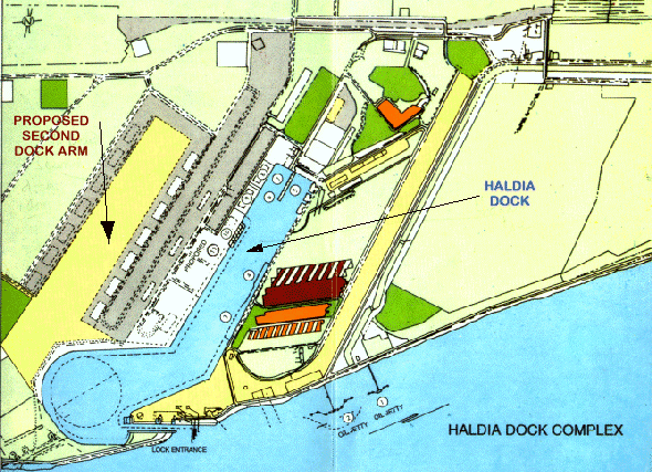
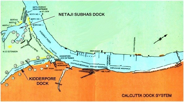
Bhutan is a land-locked country and relies on the Kolkata Port in India for handling practically all of its sea freight imports. Since the port of Kolkata is located some 700 km away from Bhutan, a detailed assessment was not possible, and the information for this LCA has been based on the Nepal LCA (conducted in 2016). The Kolkata Port Trust manages two separate dock agglomerations - the Kolkata Dock System (KDS) and the Haldia Dock Complex (HDC).
The Royal Government of Bhutan (RGOB) plans to construct one (mini-) dry port at Phuentsholing. The dry port is expected to be ready for operation by end 2019. This dry port is one of the three South Asia Sub-regional Economic Cooperation (SASEC) project components with the Phuentsholing Thromde (Municipality). The Asian Development Bank (ADB) is funding the project with a grant. Once the mini-dry port is operational, congestion at the current customs clearing space is expected to be eased as most trucks will then be diverted to the dry port. Traffic congestion in Phuentsholing town is also expected to be lessened. With the dry port ready, a cargo area that will be able to accommodate more than 45 trucks would be in place. Sufficient space for customs clearance and other works related to import and export will also be available. The dry port will be connected via the second gate from the Bau Bazaar area in Jaigaon, which is expected to be ready soon. A bypass dubbed the Northern Bypass will also be constructed through the port.
2.1.1 Bhutan Port of Kolkata (India)
Port Overview
Bhutan is a land-locked country and relies on the Kolkata Port in India for handling practically all of its sea freight imports. Kolkata Port is India's only riverine port with two dock systems – the Kolkata Dock System at Kolkata with the oil wharves at Baj Baj and a deep water dock system at Haldia Dock Complex for other seaborne trade. It has sophisticated port and extensive storage facilities for diverse cargo. The container terminal is computerized. Large volumes of humanitarian aid for Nepal passes through the Kolkata Port, such a WFP’s food.
The RGOB customs authorities have protocols in place with the Indian Government for all food aid items to be imported into Bhutan from the Port of Kolkata free of any duties or other charges.
Port website: http://kolkataporttrust.gov.in/
Key port information may also be found at:
http://www.maritime-database.com
|
Port Location and Contact |
|
|
Country |
India |
|
Province or District |
West Bengal |
|
Nearest Town or City with Distance from Port |
Kolkata |
|
Port's Complete Name |
Port of Kolkata |
|
Latitude |
22.54806 |
|
Longitude |
88.30139 |
|
Managing Company or Port Authority |
Kolkata Port Trust |
|
Management Contact Person |
Chairman: |
|
Nearest Airport and Airlines with Frequent International Arrivals/Departures |
Netaji Subhas Chandra Bose International Airport (IATA: CCU, ICAO: VECC) |
Port Picture
Description and Contacts of Key
Companies
For more information on port contacts, please see the following link:
Nepal LCA Port and Waterways Companies Contact List
Customs and Clearance Agents in Kolkata
World Port Source Port of Kolkata
Port of Kolkata Wikipedia Information
Port Performance
During 2008-09, Kolkata Port (KoPT) handled 54 million mt of traffic, compared to 57 million mt handled in 2007-08. The decline in traffic is due to the transfer of POL (crude oil) through the Paradip-Haldia Pipeline, and a decline in iron ore traffic due to the volatile iron ore market and global economic crisis. During 2008-09, KoPT ranked 5thamongst all Indian Major Ports in respect of volume of traffic handled (1st: Kandla – 72 million mt; 2nd: Visakhapatnam - 64 million mt; 3rd: Chennai – 57 million mt, 4th: JNPT – 57 million mt). KoPT ranked second among Indian major ports in coke coal handling during 2008-09; the port handled 5.93 million tons and registered a growth of 8.3 percent, higher than the average growth (7.13 percent) registered by Indian major ports. KoPT handled 429,417 TEUs in 2008-09 compared to 425,405 TEUs in 2007-08. Kolkata Port ranked third among Indian Major Ports in respect to containerized cargo handled. By handling 41,379 TEUs, KoPT surpassed its earlier record of 40,220 TEUs handled in February 2008. In August 2008, the Kolkata Dock System handled an all-time traffic record. By handling 28,128 TEUs it surpassed its earlier record of 27,562 TEUs handled in August 2007.
Customs Guidance
For more information on customs in Nepal, please see the following link: 1.3 Nepal Customs Information
For all other details on Kolkata Port, please refer to Nepal LCA (2016).
2.2 Bhutan Aviation

Key airport information may also be found at: http://worldaerodata.com/
Bhutan has only one international Airport at Paro and three domestic airports (Bumthang, Gelephu and Yonphula). Out of these three, only Bumthang domestic airport is presently operating and the other two are being improved and are likely functional from August 2017 onwards. There are two airlines, Drukair and Bhutan Airlines operating international and one airline, Drukair, operating domestic. The international airport in Badgora, India is also near in travel time to Phuentsholing.
The Bhutan Civil Aviation Authority (BCAA) regulates the overall aviation sector in Bhutan and the Department of Air Transport (DOAT) oversees the day to day operation. Bhutan Air Services (BAS) is the authorized private clearing agent responsible for assisting and co-coordinating in cleaning all the private Aircraft’s and Helicopters flying in and out of Bhutan.
Current planned enhancement of Paro International Airport include the construction of a parallel taxiway, modification of the departure terminal, construction of the an cargo terminal and construction of additional apron.
For more information on government agency and airport company contact information, please see the following links:
4.5 Bhutan Airport Companies Contact List
4.1 Bhutan Government Contact List
Procedures for Foreign Registered Aircraft
Any foreign registered aircraft, other than aircraft operating on scheduled commercial flights to Bhutan entering into Bhutan airspace, shall seek prior permission of the Bhutan Civil Aviation Authority (BCAA). BCAA has appointed, Bhutan Air Service (BAS), an authorized private clearing agent who deals with the foreign aircraft and the documentation issues.
Application (how and where to obtain it): Application for landing clearance needs to be filed at least 10 days before the scheduled flight. All applications need to be routed through BAS. A copy of the application form is attached to this LCA and it can be obtained by emailing to bhutanair@yahoo.com or bhutanair@hotmail.com or fax 00975-2-324918 (Thimphu, Head Office) 00975-8-272053 (branch office, Paro International Airport). It is to be noted that BCAA doesn’t entertain direct application to them and all application needs to be channelled through BAS.
Registration and Safety Requirements: Copy of certificate of airworthiness and registration need to be submitted to BAS along with the application. Paro International Airport is a Category ‘C’ day VFR operations. Therefore, having a navigator from Druk Air or Bhutan Airlines to assist to fly the aircraft into Paro International Airport is the requirement. The Navigator will be arranged by Bhutan Air Service. Due to wind curfew in the afternoon, it is always advisable to plan landing into Paro Airport (VQPR) before noon.
Operator, Aircraft and Crew Documentation: following documents are required at the time of filing the application.
- Details of the aircraft, registration/serial number and type of aircraft.
- Crew passport (clear original scanned copy) for visa processing
- Valid Copy of both Pilots License & Medical certificates and last page logbook copy of PIC
- A copy of the Certificate of Insurance for the Aircraft and all its occupants
- Certificate of Airworthiness and Registration copy
Other comments such as process timeline, common issues, etc.: Process timeline normally takes 6-8 working days. Fuel Jet A1 is available and the price is approximately USD 0.75 per liter (subject to change) and requires to be paid in cash (USD) for all foreign registered aircraft. All payment advisable in cash due to non-availability of credit card facilities, however an operator can also wire transfer the payment. Flight cancellation charge USD 600.00 is applicable if the flight is cancelled less than 05 days prior to arrival OR after permit approval.
2.2.1 Bhutan Paro International Airport
Airport Overview
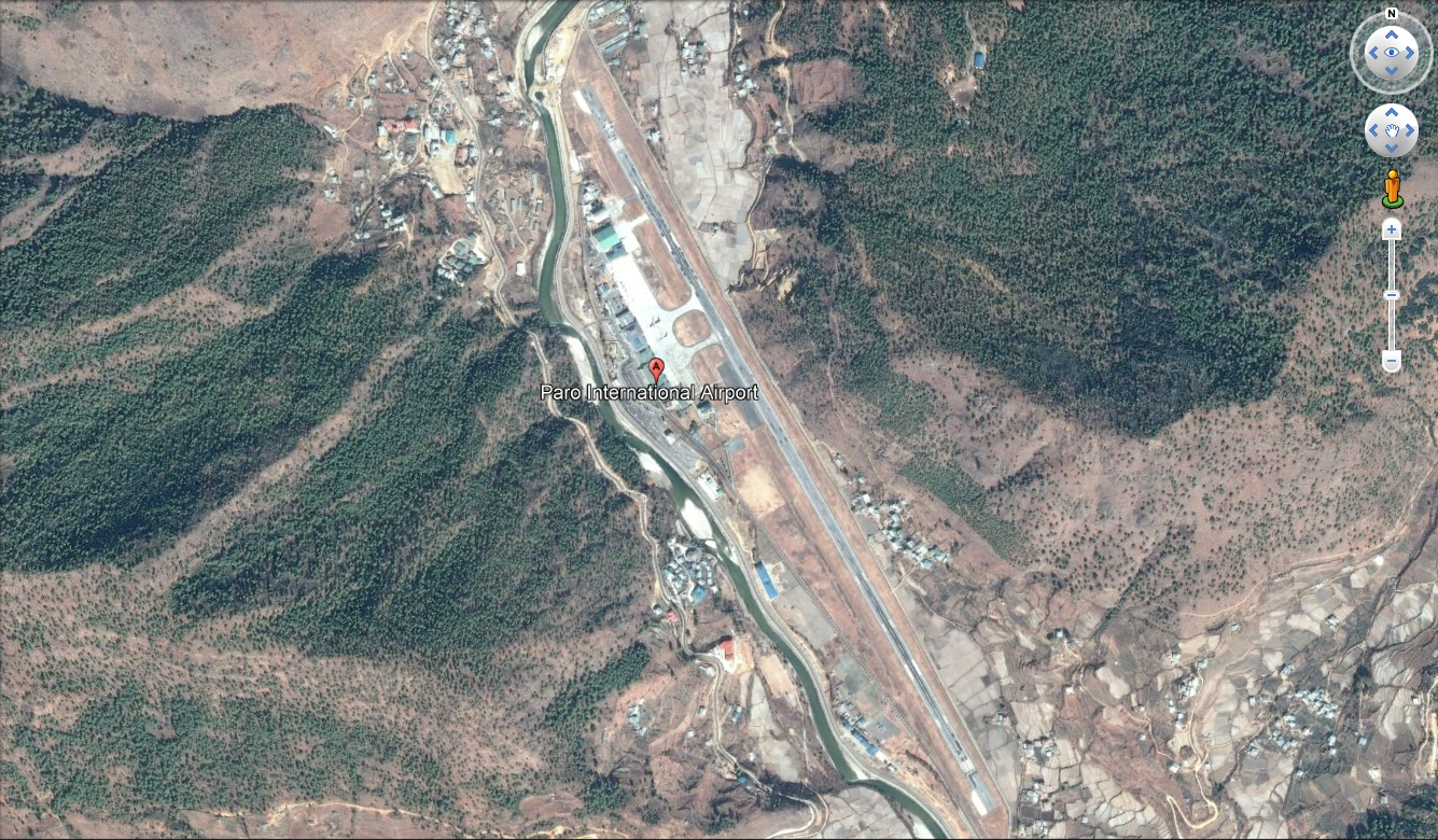
Paro is the only international airport in Bhutan. It is located in a deep valley at an elevation of 2,243 metres (7300 feet) above sea level. It is 6 km from Paro town and 55 km from the capital city, Thimphu. With surrounding peaks as high as 5,500 metres (18,000 feet), it is considered one of the world's most challenging airports to negotiate. Therefore, only with the help of a certified pilot, foreign aircraft can land at Paro. Flights to and from Paro are allowed under visual meteorological conditions only and are restricted to daylight hours from sunrise to sunset.
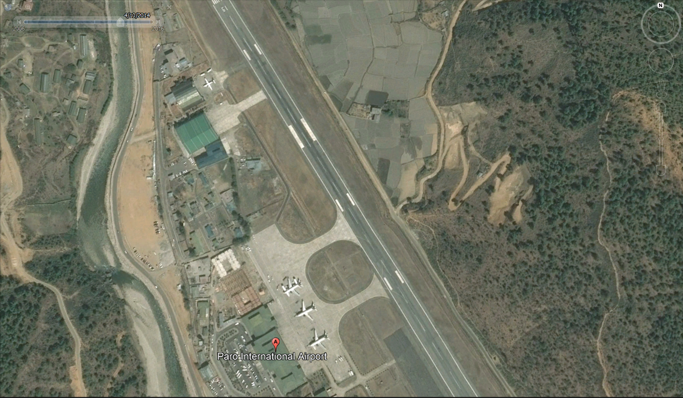
The Airport has very limited spaces for parking on the apron and can accommodate only up to five Airbus 319s. There are two airlines operating from Paro, Drukair and Bhutan Airlines. DrukaAir has three Airbus 319s and one ATR-42, while Bhutan Airlines has two Airbus 319’s. Drukair is planning to replace the A 319s with A320s – the maximum size aircraft that the airport can accommodate.
|
Airport Location and Contact |
|
|
Country |
Bhutan |
|
Province or District |
Paro |
|
Nearest Town or City |
Paro Town Distance 6 km |
|
Airport’s Complete Name |
Paro International Airport |
|
Latitude |
27o 24’11.23359” N |
|
Longitude |
89o 25’11.45278” E |
|
Elevation (feet and m) |
7,360 feet / 2,243.7 m |
|
IATA Code |
PBH |
|
ICAO Code |
VQPR |
|
Managing Company or Airport Authority |
Bhutan Civil Aviation Authority (BCAA) |
|
Management Contact Person |
Karma Wangchuk, Director |
|
Open From (hours) |
05:00 (Sunrise) |
|
Open To (hours) |
17:00 (Sunset) |
Airport Picture
Description and Contacts of Key Companies
Bhutan Air Services
Bhutan Air Services is a private organization responsible for assisting and co-coordinating in cleaning all private aircraft and helicopters flying in and out of Bhutan. All the private aircraft and helicopters visiting Bhutan should contact Bhutan Air Services for the following services:
- For any enquiries on clearance of private aircraft and helicopters visiting Bhutan;
- Obtaining Landing clearance from DCA;
- Arrangement of ground handling services;
- Arrangement of Navigator / Guide Pilot to fly the aircraft into Paro Intl. Airport;
- Arrangement of Aircraft re-fueling;
- Processing of crew visa clearance;
- Co-ordination at the airport;
- Arrangement of VIP lounge for passengers;
- Arrangement of crew hotel / transport / catering;
- Aircraft and Helicopter charter service to Bhutan;
- Obtain permission from RBA for chartered helicopters to fly to other parts of the country.
Drukair
Drukair is a Royal Government of Bhutan Owned Airline run by the Investment Wing, Druk Holding and Investments (DHI). The national Airline of the Kingdom of Bhutan operates a schedule network within the South Asian region from its headquarters at Paro.
Drukair began operations on February 11, 1983, from Paro. At the time, Paro had a little airstrip servicing helicopter operations. Drukair commenced services with a 18-seat Dornier 228-200 that made its first touch down at Paro airport on January 14, 1983. Today Drukair has three Airbus 319’s and one ATR-42-500 and flies to five South East Asian countries and nine different destinations. The table below shows Drukair's air operations.
|
Country |
City |
Airport |
|
Bangladesh |
Dhaka |
Hazrat Shahjalal International Airport |
|
India |
Bagdogra |
Bagdogra Airport |
|
Delhi |
Indira Gandhi International Airport |
|
|
Gaya |
Gaya Airport |
|
|
Kolkata |
Netaji Subash Chandra Bose International Airport |
|
|
Guwahati |
Lokpriya Gopinath Bordoloi International Airport |
|
|
Nepal |
Kathmandu |
Tribhuvan International Airport |
|
Thailand |
Bangkok |
Suvarnabhumi International Airport |
|
Singapore |
Singapore |
Changi Airport |
|
Bhutan |
Paro |
Paro International Airport (International & Domestic) |
|
Bumthang |
Bumthang Airport (Domestic) |
Bhutan Airlines
BHUTAN AIRLINES - Tashi Air Pvt. Ltd, Bhutan’s first Private Airline came into existence after the Tashi Group of Companies outbid other joint venture companies and won the license to operate Airline Service both on Domestic and International Sectors. Bhutan Airlines began its first commercial flight Paro - Bangkok on the 10th of October 2013 followed by daily scheduled flights to Kolkata on the 16th of December 2013. Today Bhutan Airline operates seven days a week flight from Bangkok to Paro via Kolkata, India and Return and 6 flights (Except on Friday) to Kathmandu and return. Table below provides Bhutan Airlines operation destinations.
|
Country |
City |
Airport |
|
India |
Delhi |
Indira Gandhi International Airport |
|
Kolkata |
Netaji Subash Chandra Bose International Airport |
|
|
Nepal |
Kathmandu |
Tribhuvan International Airport |
|
Thailand |
Bangkok |
Suvarnabhumi International Airport |
For more information on airport contacts, please see the following link:
4.5 Bhutan Airport Companies Contact List
Information on some aviation service providers can be found at: http://www.azfreight.com/
Passenger and Cargo Performance Indicator
A total of 6,328 flights and 284,074 passengers arrived and departed from Paro International Airport in 2016. The Department of Air Transport is currently working on expansion of the apron, which is expected to be completed by June 2018. With the new apron, a total of 8 mid-sized aircrafts can be accommodated.
|
Performance for 2016 |
|||
|
Per Year |
Per Month |
Per Day |
|
|
Total Aircraft Movements |
6,328 |
530 |
12 |
|
Total Passengers |
284,074 |
33,220 |
800 |
|
Total Capacity of the Airport (mt) |
1500 mt |
125 mt |
NA |
|
Current Activity of the Airport (mt) |
614 mt |
50 mt |
NA |
|
Current use by Humanitarian Flights (UNHAS) |
No |
||
Currently there is no separate cargo terminal at Paro International Airport. DOAT is constructing a new cargo terminal which is likely to be completed by June 2018. It will be 240 sqm (80 m x 30m) with a storage capacity of approximately 1,200 mt.
Runways
The runway has been lengthened on several occasions since construction and today stands at 2,165m and is asphalted. The maximum size aircraft that can land is Airbus 320/B737. There are no cargo aircraft in Bhutan. However, the airport officials advise that an Indian Air Force C-130 has landed at this airport and an Il-76 should be able to land without problems.
This is a very important point to note for delivery of air cargo in a national emergency.
|
Runway #1 |
|
|
Runway Dimensions |
Length (2,165m) x Width (30m) |
|
Orientation |
15/33 |
|
Surface |
Asphalt |
Helicopter Pads
There are two helipads within Paro International Airport which are under the management of Royal Bhutan Helicopter Services Limited. The helipads can accommodate two helicopters landing at a time. It is asphalted and in good condition.
|
Helipads |
|
|
Present |
Yes |
|
Largest helicopter that can Land |
MI-26 |
|
Width and Length (m) |
80 metres (L) X 60 metres (W) |
|
Surface |
Asphalt |
Airport Infrastructure Details
|
Customs |
Yes |
JET A-1 fuel |
Yes |
|
Immigration |
Yes |
AVGAS 100 |
NA |
|
Terminal Building |
Yes |
Single Point Refuelling |
Yes |
|
Passenger Terminal |
Yes |
Air Starter Units |
NO |
|
Cargo terminal |
No |
Ground Power (mobile) |
Yes |
|
Pax Transport to Airfield |
No |
Ground Handling Services |
Yes |
|
Control Tower |
Yes |
Latrine Servicing |
Yes |
|
Weather Facilities |
Yes |
Fire Fighting Category (ICAO) |
Yes |
|
Catering Services |
Yes |
De-icing Equipment |
No |
|
Base Operating Room |
Yes |
Parking Ramp Lighting |
No |
|
Airport Radar |
Yes |
Approach & Runway Lights |
No |
|
NDB |
No |
VOR |
Yes |
|
ILS |
No |
Airport Operating Details
|
Operating Details |
|||
|
Maximum Sized Aircraft that can be Offloaded on Bulk Cargo |
Airbus A319 / A320 |
||
|
Maximum Sized Aircraft that can be Offloaded on Pallet |
NA |
||
|
Total Aircraft Parking Area (m²) |
Presently there is parking space for five Airbus 319 (128 metres X 45 metres), additional apron is being constructed that will have 126 X 52 m. |
||
|
Storage Area |
200 MT |
||
|
Handling Equipment |
|||
|
Elevators / Hi Loaders |
No |
Max Capacity (MT) |
|
|
Max Height (m) |
|
||
|
Loading Ramps |
Yes |
||
|
Other Comments |
|
||
Customs Guidance
No major issues with customs clearance. Office within airport arrival terminal.
Contact: Mr. Ugyen Thinley, +975-17625627
For more information on customs in Bhutan, please see the following link:
1.3 Bhutan Customs Information
Storage Facilities
Currently there are no proper storage facilities at the airport. A temporary storage is used which can accommodate around 200 mt. However, plans are in place to construct a new cargo terminal that will have storage facilities of around 350 mt.
Airfield Costs
NAVIGATION CHARGES
The civil aviation act of Bhutan stipulates that ‘there is no navigation charges for foreign military aircraft and aircraft used solely for the transportation of the representatives of foreign States or of United Nations personnel.” However, navigation charges are levied for all other types of aircraft landing at Paro International Airport. Navigation charges are provided in the table below;
Regarding payment, except as approved by DOAT, all fees except the passenger service charge shall be paid by the commander of the aircraft or agent without demand before the aircraft departs from the aerodrome. All payments of fees are to be made in US Dollar or Bhutanese Currency. Fees shall be paid to the Bhutan Air Service, clearing agent and if not so paid shall be made to the CAA jointly and severally from the owner or agent and the commander of the aircraft in respect of which the fees are payable.
In addition to navigation, landing, parking and handling charges, there are other fees payable, viz. Navigator arrangement charges amounts to USD 500 per aircraft, passenger service fee of USD 14 (Airport tax/PSF) and VIP lounge charge of USD 50 per person (during peak tourist season) and USD 25 per person (during low season).
|
Charges |
Aircraft Weight - MTOW (kg) |
||
|
0 - 7,000 |
7,001 - 136,000 |
136,001 and over |
|
|
Navigation (per journey) USD - $ |
USD10 |
USD 20 |
USD 30 |
|
Landing USD - $ |
USD 124 |
USD 124 |
USD 124 |
|
Night Landing USD - $ |
NA |
NA |
NA |
|
Night Take-Off USD - $ |
NA |
NA |
NA |
|
Parking |
USD 10 |
USD 10 |
USD 10 |
|
Handling Charges |
USD 750 (for turnaround within 3 hr) USD 850 (for over 3 hr and night stop) |
USD 1,100 (for turnaround within 3 hr) USD 1,250 (for over 3 hr and night stop) |
USD 1,700 (for turnaround within 3 hr) USD 1,950 (for over 3 hr and night stop) |
FUEL SERVICES CHARGES
Bhutan Oil Corporation provides the Jet A1 fuel to all aircrafts at Paro International Airport. The price of fuel is regulated and fixed by the Department of Trade under the Ministry of Economic Affairs.
|
Price per Litre USD - $ |
|
|
Jet A-1 |
USD 0.75 |
|
Avgas |
NA |
CARGO TERMINAL CHARGES
Presently there is no functional cargo terminal at Paro International Airport. Construction of a new cargo terminal is on-going and is expected to be completed by June 2018. The New terminal will have storage capacity of around 1,200 MT and 240 m2 (80 m x 30 m).
|
Import Charges |
||
|
Type of Charge |
Rate USD - $ per kg |
Comments |
|
Handling Charge |
NA |
|
|
Break Bulk Fee |
NA |
|
|
Diplomatic Mail |
NA |
|
|
Strong Room – per consignment |
NA |
|
|
Cold Storage Fee |
NA |
|
|
Delivery Outside Normal Working Hours |
NA |
|
|
Preparation of substitute AOA – Invoice – Receipt |
NA |
|
|
Storage per Day |
NA |
|
|
Export |
||
|
Handling Charges – Un-palletized Cargo |
NA |
|
|
International Air Waybill |
NA |
|
|
Local Air Waybill |
NA |
|
|
Air Way Bill Amendment - Cancellation |
NA |
|
|
Air Way Bill Documentation |
NA |
|
|
Diplomatic Mail |
NA |
|
|
Storage Charges per Day |
NA |
|
AIR-BRIDGE CHARGES
There are no air bridges available at Paro International Airport.
Security
The DOAT has its own arrangement for the security of the interior part of the Airport while the Royal Bhutan Army (RBA) manages the external security. Currently DOAT has around 70 security personnel.
2.2.2 Bhutan Gelephu Domestic Airport
Airport Overview
The airport is located on the border of Bhutan and India in the south central part of the country. The airport is likely to be operational by end July 2017.
|
Airport Location and Contact |
|
|
Country |
Bhutan |
|
Province or District |
Sarpang |
|
Nearest Town or City |
Gelephu 5 km |
|
Airport’s Complete Name |
Gelephu Domestic Airport |
|
Latitude |
N 26o 53’ 15.93” |
|
Longitude |
E 90o27’27.043” |
|
Elevation (feet and metres) |
705 ft / 215 m |
|
IATA Code |
GEL |
|
ICAO Code |
VQGP |
|
Managing Company or Airport Authority |
Depart of Air Transport, Ministry of Information and Communication |
|
Management Contact Person |
Mr. Sonam Phuntsho |
|
NGO and/or UN Presence at Airport? |
No |
Runway
|
Runway |
|
|
Runway Dimensions |
1500 (m) X 30 (m) |
|
Runway Orientation |
11/29 |
|
Runway Surface |
Asphalt |
|
Runway Condition |
Good |
Airport Infrastructure Details
|
Infrastructure |
|||
|
Passenger / Cargo Security Screening |
Yes |
Runway Lighting |
No |
|
Refuelling Capacity |
No |
Ground Handling Services |
No |
|
Air Traffic Control |
Yes |
Fire Fighting Equipment |
Yes |
|
Weather Information |
Yes |
Aircraft Parking Space |
No |
|
Navigation Aids |
No |
Perimeter Fencing |
Yes |
|
Windsock |
Yes |
|
|
Fuel Services Charges
|
Price per Litre USD - $ |
|
|
Jet A-1 |
No (soon to be established) |
|
Avgas |
No |
Royalties / Non Objection Fees (NOFs)
Not applicable
2.2.3 Bhutan Yonphula Domestic Airport
Airport Overview
Landing only possible from vector 12 and departure from vector 30. Airport likely to be completed in August 2017 and operational from September 2017.
There are no helipad facilities, Helicopters can land on the runway and park on the apron as designated by the ATC.
Airport can land ATR 42’s but number of passengers restricted to 24 due to high elevation (2,559m).
Only taxi links to the airport are available.
|
Airport Location and Contact |
|
|
Country |
Bhutan |
|
Province or District |
Trashigang |
|
Nearest Town or City |
Kanglung 9 km |
|
Airport’s Complete Name |
Yonphula Domestic Airport |
|
Latitude |
N 27o 15’ 33.83” |
|
Longitude |
E 91o30’34.55” |
|
Elevation (ft and m) |
8,359 feet / 2,559 metres |
|
IATA Code |
YON |
|
ICAO Code |
VQTY |
|
Managing Company or Airport Authority |
Depart of Air Transport, Ministry of Information and Communication |
|
Management Contact Person |
Mr. Tshiltrim Drakpa |
|
NGO and/or UN Presence at Airport? |
No |
Runway
|
Runway |
|
|
Runway Dimensions |
1200 (m) X 30 (m) |
|
Runway Orientation |
12/30 |
|
Runway Surface |
Asphalt |
|
Runway Condition |
Good |
Airport Infrastructure Details
|
Infrastructure |
|||
|
Passenger / Cargo Security Screening |
Yes |
Runway Lighting |
No |
|
Refuelling Capacity |
No |
Ground Handling Services |
No |
|
Air Traffic Control |
Yes |
Fire Fighting Equipment |
Yes |
|
Weather Information |
Yes |
Aircraft Parking Space |
Yes |
|
Navigation Aids |
Yes |
Perimeter Fencing |
Yes |
|
Windsock |
Yes |
|
|
Fuel Services Charges
|
Price per Litre USD - $ |
|
|
Jet A-1 |
No (soon to be established) |
|
Avgas |
No |
Royalties / Non Objection Fees (NOFs)
No landing fees charged at the moment.
2.2.4. Bhutan Bumthang/Bathpalathang Domestic Airport
Airport Overview
Also called Bathpalathang Airport, it is located beside a river and landing and take-off can be carried out from either end of the airport. The airport is mainly used for tourist purposes and the maximum usual size aircraft are ATR 42s. The A319 can land there but ATR 42 is the regular size. The maximum number of passengers in the ATR 42 is 32, due to meteorological and topographical factors.
There is sufficient asphalted parking area on the apron and this could be used for landing helicopters and temporary warehousing could be constructed in the event of an emergency.
The airport and control tower are fully operational for day light operations barring extreme inclement weather. The approach road to the airport is very narrow and has dirt surface in sections.
Operations started December 17 2011. Elevation difference is 0.83%. There is one daily flight from Paro. As per the schedule, only 3 flights a week.
|
Airport Location and Contact |
|
|
Country |
Bhutan |
|
Province or District |
Bumthang |
|
Nearest Town or City |
Chamkhar, 2 KMS |
|
Airport’s Complete Name |
Bumthang Domestic Airport |
|
Latitude |
N 270 33’43.92’ |
|
Longitude |
E 90o44’49.72’ |
|
Elevation (feet and m) |
8,464 feet / 2580 metres |
|
IATA Code |
BUT |
|
ICAO Code |
VQBT |
|
Managing Company or Airport Authority |
Department of Air Transport, Ministry of Information and Communication |
|
Management Contact Person |
Ms. Tashi Lhamo |
|
NGO and/or UN Presence at Airport? |
No |
Runway
|
Runway |
|
|
Runway Dimensions |
1200 m X 30 m |
|
Runway Orientation |
14/32 |
|
Runway Surface |
Asphalt |
|
Runway Condition |
Good |
One asphalt parking available for ATR and a helicopter off main runway.
Soon planning to equip the airport with fuel refuelling.
Airport Infrastructure Details
|
Infrastructure |
|||
|
Passenger / Cargo Security Screening |
Yes |
Runway Lighting |
No |
|
Refuelling Capacity |
No (potentially to be fitted in the near future) |
Ground Handling Services |
No |
|
Air Traffic Control |
Yes |
Fire Fighting Equipment |
Yes |
|
Weather Information |
Yes |
Aircraft Parking Space |
Yes |
|
Navigation Aids |
Yes |
Perimeter Fencing |
Yes |
|
Windsock |
Yes |
|
|
Fuel Services Charges
No refuelling services at present, potentially soon to be
established.
Royalties / Non Objection Fees (NOFs)
Not applicable
2.3 Bhutan Road Network

Overview
The Department of Roads (DoR), under Ministry of Works and Human Settlement is responsible for the construction and maintenance of the road network in the country. As Bhutan is a landlocked country, road transport is the dominant mode of transportation for passengers and freight within the country and to the neighbouring states (Assam and West Bengal) of India. At present, Bhutan has a total of 12,000 km of motorable roads. The Border Roads Organization (BRO) under project DANTAK, a subdivision of the Indian Army Corps of Engineers, has been operating in Bhutan since May 1961. Since then Project DANTAK has been responsible for the construction and maintenance of over 680 km of roads and bridges, Paro Airport and the airfield at Yangphula, heliports and other infrastructure. While these serve India's strategic defence needs, they are also an obvious economic benefit for the people of Bhutan
Out of the total road network of around 12,000 km, which are composed of the 2,000 km of primary national highways, 650 km of secondary national highways, 350 km of Thromde (a third-level administrative division in Bhutan similar to a municipality under a Mayor) roads and remaining as farm, feeder and access roads. Some 2,500 km of roads are under DoR, about 680 km under Project Dantak, and the balance of remaining roads are under municipal (Thromde), Dzongkhag (national administration districts) and the Ministry of Agriculture and Forest (MoAF).
The Department of Roads (DoR) carries out road routine maintenance works through using national workforce dedicated for the purpose. The approach adopted for the execution of routine maintenance is input based where a fixed number of workforces are dedicated for the maintenance of a given section of the road using a maintenance work norm of 1 workforce per 1 km for national highway, 1 workforce per 1.5 km for district road and 1 workforce per 2 km for feeder road.
Due to its mountainous terrain and fragile topography, roads in Bhutan often get blocked by landslides and mud slides especially during the monsoon season that spans from May to August. Most of the roads are narrow, except some primary highways that are double lane, and large vehicles and trailers cannot pass through. Sea containers are offloaded at the border town, Phuentsholing and cargo transhipped into smaller trucks for further transportation to the interior of the country.
Except for Thimphu-Phuentsholing, Paro-Thimphu and Thimphu-Wangduephodrang primary national highways, all other roads are only single lane. DoR with assistance from the Government of India and other donors is presently expanding the east–west and Samdrupjongkhar-Trashigang highways. Bypasses are also being constructed at a number of places to shorten the distance of highways. Notable bypasses include:
a) Damchu-Chukha bypass which will reduce the distance between Thimphu and Phuentsholing by around 19 km.
b) Chumey-Ura bypass
c) Wangdigang-Tingtibi bypass.
For more information on government contact details, please see the following link:
4.1 Bhutan Government Contact List
Distance Matrix
|
Distances from Capital City to Major Towns (km) |
||||||||
|
Thimphu |
Phuentsholing |
Paro |
Punakha |
Mongar |
Trashigang |
Gelephu |
Samdrup Jongkhar |
|
|
Thimphu |
172 |
55 |
72 |
450 |
551 |
256 |
731 (520*) |
|
|
Phuentsholing |
172 |
165 |
234 |
622 |
713 |
195* |
348* |
|
|
Paro |
55 |
165 |
117 |
495 |
601 |
306 |
513* |
|
|
Punakha |
72 |
234 |
117 |
412 |
503 |
208 |
582* |
|
|
Mongar |
450 |
622 |
495 |
412 |
91 |
505 (504*) |
271 |
|
|
Trashigang |
551 |
713 |
601 |
503 |
91 |
596 (413*) |
180 |
|
|
Gelephu |
256 |
195* |
306 |
208 |
505 (504*) |
596 (413*) |
233* |
|
|
Samdrup Jongkhar |
731 |
348* |
513* |
582* |
271 |
180 |
233* |
|
* Route through Indian road.
|
Travel Time from Capital City to Major Towns (hours or days) |
||||||||
|
Thimphu |
Phuentsholing |
Paro |
Punakha |
Mongar |
Trashigang |
Gelephu |
Samdrup Jongkhar |
|
|
Thimphu |
5 hr |
1 hr |
2 hr |
1.5 days |
2 days |
8 hr |
3 days |
|
|
Phuentsholing |
5 hr |
6 hr |
8 hr |
2 days |
3 days |
6 hr |
10 hr |
|
|
Paro |
1 hr |
6 hr |
3 hr |
1.5 days |
2 days |
7 hr |
3 days |
|
|
Punakha |
2 hr |
8 hr |
3 hr |
1.5 days |
2 days |
6 hr |
3 days |
|
|
Mongar |
1.5 days |
2 days |
1.5 days |
1.5 day |
4 hr |
2 days |
1 day |
|
|
Trashigang |
2 days |
3 days |
2 days |
2 days |
4 hr |
2 days |
7 hrs |
|
|
Gelephu |
8 hr |
6 hr |
7 hr |
6 hr |
2 days |
2 days |
1 day |
|
|
Samdrup Jongkhar |
3 days |
1 day |
3 days |
3 days |
1 day |
7 hr |
1 day |
|
Road Security
Generally, there are no security threats related to roads within Bhutan; however roads that pass through Indian borders, especially through the Indian states of Assam and West Bengal can sometimes pose security threats due to demonstrations and strikes. Between 2003-2008, the Government of India used to provide military escort to all Bhutanese vehicles plying these roads due to security threats from ULFA and BODO militants. These escorts were in use up to around 2013, though their use has been reduced or stopped due to the reduction of the threat.
The Royal Government of Bhutan has accorded high priority to safety, reliability and efficiency of the road transport system; the existing highways are being widened to allow two vehicles (at least one heavy and one light) to cross each other, safety measures such as crash barriers and reflectors are being installed along accident prone sections of various highways, and sections of existing highways are being realigned to shorten the travel distance and also to avoid landslide prone areas. Existing highway bridges are also being strengthened and replaced with permanent steel or reinforced concrete bridges. DoR has placed machines at strategic locations to clear the road in case of blocks due to landslides and mudslides.
However, general road conditions beyond national highways are poor, and emergency services generally are not available. Because of the mountainous terrain, roads tend to have steep drop-offs and blind curves.
Weighbridges and Axle Load Limits
Department of Revenue and Customs, under the Ministry of Finance operates weighbridges at the border towns. Weighbridges are located at Phuentsholing, Gelephu, Samdrup Jongkhar and Gomtu. There are no privately owned weighbridges in the country. All trucks carrying goods to Bhutan have to be checked at these weighbridges and get at report. These reports are checked and analysed by the Road Safety and Transport Authority (RSTA). Load limits for various kinds of trucks are mentioned below.
|
Axle Load Limits |
LCA Country (BHUTAN) |
Transit Country #1 (INDIA) |
|
Truck with 2 Axles |
10 mt |
10 mt |
|
Truck with 3 Axles |
15 mt |
NA |
|
Truck with 4 Axles |
18 mt |
NA |
|
Semi-trailer with 3 Axles |
NA |
NA |
|
Semi-trailer with 4 Axles |
NA |
NA |
|
Semi-trailer with 5 Axles |
NA |
NA |
|
Semi-trailer with 6 Axles |
||
|
Truck & Drawbar Trailer with 4 Axles |
||
|
Truck & Drawbar Trailer with 5 Axles |
||
|
Truck & Drawbar Trailer with 6 Axles |
||
|
Truck & Drawbar Trailer with 7 Axles |
Road Class and Surface Conditions
INSERT RELEVANT maps (as needed) from the WFP GIS Team.
2.3.1. Bhutan Border Crossing of Gelephu
Overview
Gelephu is located on the border between Bhutan and India. There is a regional airport 5 km west of Gelephu which is described elsewhere in this LCA. While Gelephu is a major community with a mayor (Thrompon), the location is not an ideal entry or exit point between Bhutan and India because of the very poor condition of the road between the border and Highway 31 in India.
|
Border Crossing Location and Contact |
|
|
Name of Border Crossing |
NA |
|
Province or District |
Sarpang |
|
Nearest Town or City with Distance from Border Crossing |
Santabari in India on Highway 31 About 43 km |
|
Latitude |
26°52′14″N |
|
Longitude |
90°29′08″E |
|
Managing Authority / Agency |
Customs and Immigration |
|
Contact Person |
NA |
|
Travel Times |
|
|
Nearest International Airport |
Paro 242.4 km via Wangdue - Tsirang Highway Truck Travel Time: 9 hours Car Travel time: 7 hours |
|
Nearest Port |
Kolkata (India) Distance 830 km Truck Travel Time: 19 hours |
|
Nearest location with functioning wholesale markets, or with significant manufacturing or production capacity |
NA |
|
Other Information
|
NA |
|
Hours of Operation |
|
|
Mondays |
0900 – 1700 Summer 0900 – 1600 Winter |
|
Tuesdays |
0900 – 1700 Summer 0900 – 1600 Winter |
|
Wednesdays |
0900 – 1700 Summer 0900 – 1600 Winter |
|
Thursdays |
0900 – 1700 Summer 0900 – 1600 Winter |
|
Fridays |
0900 – 1700 Summer 0900 – 1600 Winter |
|
Saturdays |
0900 – 1700 Summer 0900 – 1600 Winter |
|
Sundays |
0900 – 1700 Summer 0900 – 1600 Winter |
|
National Holidays
|
All government departments are closed for national holidays |
|
Seasonal Constraints |
During the monsoon season, the crossing area is subject to frequent flooding as in low lying area on the border with a large river flowing through to India |
Daily Capacity
This is a busy border crossing with small commercial shops on either side of the border. Asphalt surface on Bhutan side and a mixture of asphalt and unsealed on the Indian side of the border. Maximum two lanes and no information on traffic flow except to say quite slow. Cars and trucks not provided with separate lanes
Customs Clearance
No details for private commerce however food aid items can cross the border with customs clearance on production of the usual documentation.
For more information on government contact details, please see the following links:
2.3.2 Bhutan Border Crossing of Samdrup Jongkhar
Overview
This is a busy border town between Bhutan and India. The town is located at the south-eastern part of Bhutan and borders the Indian state of Assam. it is one of the most importanttrading towns for the eastern districts of Bhutan. There is a very good asphalt road between the border and Rangia on Indian National Highway 31.
|
Border Crossing Location and Contact |
|
|
Name of Border Crossing |
Not applicable |
|
Province or District |
Samdrup Jongkhar |
|
Nearest Town or City with Distance from Border Crossing |
Trashigang 180km by road |
|
Latitude |
26°48′02″N |
|
Longitude |
91°30′18″E |
|
Managing Authority / Agency |
Customs and Immigration |
|
Contact Person |
Not applicable |
|
Travel Times |
|
|
Nearest International Airport |
Guwahati in Asam, India - 98 km by road Truck Travel Time: 3-4 hours Car Travel time: 2.5 hours Paro International Airport 513 km by road Truck Travel Time: 12 hours Car Travel time: 10 to 11 hours |
|
Nearest Port |
Kolkata (India) Distance 967 km via NH 31 Truck Travel Time: 21 Hours Car Travel time: 19 hours |
|
Nearest location with functioning wholesale markets, or with significant manufacturing or production capacity |
Samdrup Jongkhar is a significant market town and the principal commercial location in south eastern Bhutan. There is a large farmers’ auction for selling vegetables into the Indian market. The nearest large wholesale market is Guwahati, capital of the Indian state of Assam, some 160 km from the border or 3-4 hours driving time. |
|
Other Information
|
No weighbridges or major fuel depots. Many individual petrol stations |
|
Hours of Operation |
|
|
Mondays |
0900 – 1700 Summer 0900 – 1600 Winter |
|
Tuesdays |
0900 – 1700 Summer 0900 – 1600 Winter |
|
Wednesdays |
0900 – 1700 Summer 0900 – 1600 Winter |
|
Thursdays |
0900 – 1700 Summer 0900 – 1600 Winter |
|
Fridays |
0900 – 1700 Summer 0900 – 1600 Winter |
|
Saturdays |
0900 – 1700 Summer 0900 – 1600 Winter |
|
Sundays |
0900 – 1700 Summer 0900 – 1600 Winter |
|
National Holidays
|
All government departments are closed during national holidays |
|
Seasonal Constraints |
During Monsoon season, subject to frequent flooding as situated in a low lying area |
Daily Capacity
This is a busy border crossing with small commercial shops on either side of the border. Asphalt surface on Bhutan side and a very good asphalt road to the Indian town of Rangia (Assam state) situated on NH 31 – the distance is about 55 km.
NH 31 is mainly a 4 lane highway and it is the road of preference to travel between the major southern towns of Bhutan namely, Samdrup Jongkhar in the east, Gelephu in the centre and Phuentsholing in the east.
In rating the capacity to handle trucks and a good road surface, Samdrup Jongkhar rates second to Phuentsholing and ahead of Gelephu.
Customs Clearance
No details for private commerce however food aid items can cross the border with customs clearance on production of the usual documentation.
For more information on government contact details, please see the following links:
2.3.3 Bhutan Border Crossing of Phuentsholing
Overview
Phuntsholing is a border town in southern Bhutan in Chukha District. Phuentsholing adjoins the Indian town of Jaigon, and cross-border trade has resulted in a thriving local economy.
Whereas Thimphu is the political capital of Bhutan, Phuentsholing is certainly the commercial capital where the offices and depots of the major oil wholesalers, major merchants and major transporters are located.
South of the border, there is an excellent 2 lane asphalt road (which is being widened to 4 lanes) to Hasimara on NH 31 – a distance of about 17 km. Hasimara is a major commercial town on the highway with train service east and west. It is also home to a military airport of the Indian Airforce.
Plans to join the rail link up to the border with Bhutan have been under discussions for many years but are yet to be materialized due to extensive problems arising from the need to acquire the necessary land for building the railway tracks. Any progress in this regard should not be expected in the near future.
North of Phuentsholing, the national highway maintained by Dantak joins both Paro and Thimphu.
|
Border Crossing Location and Contact |
|
|
Name of Border Crossing |
Bhutan: Phuentsholing |
|
Province or District |
Chukha |
|
Nearest Town or City with Distance from Border Crossing |
Paro Distance 165 km Thimphu Distance 172 km |
|
Latitude |
26°51'37.05"N |
|
Longitude |
89°23'37.65"E |
|
Managing Authority / Agency |
Customs and Immigration |
|
Contact Person |
NA |
|
Travel Times |
|
|
Nearest International Airport |
Paro (Bhutan); Bagdora (India) Distance 165 km (Paro) ; 158 km (Bagdora) Truck Travel Time: 4 – 6 hours (Paro); 3-4 hours (Bagdora) Car Travel time: 4 hours (Paro); 2.5-3 hours (Bagdora) |
|
Nearest Port |
Kolkota Distance 707 km via NH 12 Truck Travel Time: 15 – 20 hours Car Travel time: 14 hours |
|
Nearest location with functioning wholesale markets, or with significant manufacturing or production capacity |
Name: Siliguru (West Bengal, India) Distance in km: 155 km Truck Travel Time: 5-6 hr Car Travel time: 3-4 hr |
|
Other Information
|
Not applicable, route not traversed |
|
Hours of Operation |
|
|
Mondays |
0900 – 1700 Summer 0900 – 1600 Winter |
|
Tuesdays |
0900 – 1700 Summer 0900 – 1600 Winter |
|
Wednesdays |
0900 – 1700 Summer 0900 – 1600 Winter |
|
Thursdays |
0900 – 1700 Summer 0900 – 1600 Winter |
|
Fridays |
0900 – 1700 Summer 0900 – 1600 Winter |
|
Saturdays |
0900 – 1700 Summer 0900 – 1600 Winter |
|
Sundays |
0900 – 1700 Summer 0900 – 1600 Winter |
|
National Holidays
|
All government departments closed on national holidays. Private companies remain open. |
|
Seasonal Constraints |
The river Ammo which flows from the district of Haa is subject to flooding in the estuary which adjoins Phuentsholing. Major works are being carried out to divert the river to the west of Phuentsholing and reclaim land for further expansion. |
Daily Capacity
This border crossing is the major commercial hub and entry / exit point between Bhutan and India. The actual border crossing is quite narrow and can result in hold ups for both trucks and cars. Dry port facilities in Phuentsholing are limited at present but major expansion is in the planning to accommodate a major dry port where larger quantities of containers can be stripped and cleared by customs. There is a functional weighbridge in the centre of the town.
Customs Clearance
There is a major customs office in Phuentsholing and the management is acutely aware that Phuentsholing is the principal land entry and exit point for Bhutan.
Facilities are being improved on a regular basis
For more information on government contact details, please see the following link:
2.4 Bhutan Railway Assessment
Bhutan has no railway system and it is highly unlikely that any railways system would be constructed in Bhutan due to the highly mountainous nature of the topography and instability of the terrain due to frequent mud slides and the risks of earthquakes.
There are proposals to link the Indian railway network from Hasimara to Phuentsholing – a distance of some 17 km – though this is not expected to materialise in the near future.
2.5 Bhutan Waterways Assessment

The river system throughout the country is so fast flowing that there is no possibility of using the rivers for transport of food or non-food items during a crisis.
The rivers (excepting the Manas and Lhobhrak) flow from the side of the Great Himalayas through the narrow defiles at the foot of the mountains, emerging into the Duar and eventually draining into the Brahmaputra River.
There are no flood problems in the mountain regions but serious threats of floods exist in the plains, although the alluvium makes the soil there fertile.
The total length of rivers, with their tributaries, in Bhutan is about 7,200 km. The principal rivers are, from west to east: Amo Chu or Torsa, Wong Chu or Raidak, Mo Chu or Sankosh and Manas.
2.6 Bhutan Storage Assessment
Overview
The Food Corporation of Bhutan Ltd. (FCBL) has the largest network of warehouses throughout the country. It has 47 warehouses and transit stores across 20 districts of Bhutan with total storage capacity of 19,000 MT. Furthermore, it has currently 119 farm shops, each with minimum storage capacity of 5 mt, located in the remote corners of country, which can be used as mini storage if needed. There is a plan to expand to a total of 205 farm shops across the country. Although some of the warehouses are not up to standard, in terms of storage of food items, WFP considers that Bhutan has adequate capacity.
On the flipside, there are no identified warehouses for storage of non-food items except for very few district and central stores. Furthermore, there are not many commercial storage facilities available in Bhutan. During emergencies, one possibility could to use school auditoriums as warehouses since schools are located in each and every districts and sub-districts and furthermore, during emergencies, classes might be empty and thus could be converted into temporary emergency stores. This is however not a preferred option as it would delay the return to normal functioning of schools for their education roles.
FCBL maintains the "National Food Security Reserve” held in strategic warehouses throughout the country. This was established originally with assistance from WFP in 1991. The food stock consists of some 1,400 mt of rice, 200 mt of sugar and 58 mtof cooking oil. The table below provides the locations where these reserves are held. However, considering the population growth, the CEO of FCBL projects that Bhutan presently might require around 4,150 mt (3,500 mt Rice, 300 mt Oil, 250 mt Sugar and 100 mt Salt) to provide for the needs of some 12 percent (poverty index based on 2012 figures) of the population for three months. The distribution across the country might also need a review once the data of the latest sensus are available.
National Food Security Reserve Stock Level
|
Commodities |
Locations and quantities of reserve (mt) |
|||||||
|
P/ling |
Thimphu |
Trongsa |
S/Jong |
Khangma |
Trashiang |
Mongar |
Total |
|
|
Rice |
220 |
300 |
80 |
350 |
225 |
25 |
200 |
1,400 |
|
Sugar |
30 |
80 |
10 |
40 |
20 |
5 |
15 |
200 |
|
Oil |
20 |
14 |
4 |
10 |
5 |
1 |
4 |
58 |
|
Total |
270 |
394 |
94 |
400 |
250 |
31 |
219 |
1,658 |
For more information on storage company contact details, please see the following link:
4.6 Bhutan Storage and Milling Companies Contact List
Commercial Storage
Commercial storage facilities are almost non-existent in Bhutan except a handful of them located in Phuentsholing. Notable commercial storage are as follows:
|
Location |
Owner |
Available for Rent |
Capacity (MT / m² / m³) |
Type [1] |
Access [2] |
Condition [3] |
|
Near Norgay hall, Phuentsholing |
Choden Tshongkhang |
Yes |
500 mt |
Concrete |
Flat |
Appears intact |
|
Yarkay Complex, P/ling |
Yarkey Group of Companies |
Yes |
1000 mt |
Concrete |
Raised-Siding |
Appears intact |
|
Near Truck Parking, Phuentsholing |
Druk Norlah |
Yes |
200 mt |
Concrete |
Flat |
Appears intact |
|
Karma Feeds Complex, Phuentsholing |
Karma Feeds |
Yes |
500 mt |
Concrete |
Flat |
Appears intact |
[1] Warehouse Type: Open storage, container, rub-hall, silo, concrete, other, unspecified
[2] Warehouse Access: Raised-siding, flat
[3] Warehouse condition: Appears intact, appears damaged, under construction/repair
Storage Used by Humanitarian Organizations
The World Food Programme Country Office in Bhutan uses the Food Corporation of Bhutan Ltd (FCBL) warehouses to store its food and non-food items. FCBL has three main warehouses at Phuentsholing, Gelephu and Samdrup Jongkhar and many other transit warehouses all over Bhutan. FCBL is amenable when it comes to sharing the warehouse space with other humanitarian agencies provided they get prior approval from their management. The table below shows various warehouses used by WFP and UNICEF.
|
Location |
Organization |
Sharing Possibility |
Capacity (MT / m² / m³) |
Type [1] |
Access [2] |
Condition [3] |
|
Phuentsholing |
WFP |
Yes |
200 mt |
Concrete |
Raised -siding |
appears intact |
|
Phuentsholing |
WFP |
Yes |
1,100 mt |
Concrete |
Raised -siding |
appears intact |
|
Gelephu |
WFP |
Yes |
800 mt |
Concrete |
Raised -siding |
appears intact |
|
Gelephu |
WFP |
Yes |
200 mt |
Rub- hall |
Raised -siding |
appears intact |
|
Samdrup Jongkhar |
WFP |
Yes |
1,520 mt |
Concrete |
Raised -siding |
appears intact |
|
Khangma, Trashigang |
WFP |
Yes |
400 mt |
Concrete |
Flat |
appears intact |
|
Khangma, Trashigang |
WFP |
Yes |
200 Mmt |
Rub- hall |
Raised -siding |
appears intact |
|
Rangjung, Trashigang |
WFP |
Yes |
55 mt |
Concrete |
Raised -siding |
appears intact |
|
Gorgoan, Lhuntse |
WFP |
Yes |
55 mt |
Concrete |
Raised -siding |
appears intact |
|
Nanglam, Samdrup Jongkhar |
WFP |
Yes |
80 mt |
Concrete |
Raised -siding |
appears intact |
|
Daifarm, Samdrup Jongkhar |
WFP |
Yes |
40 mt |
Concrete |
Flat |
appears intact |
|
Samtse |
WFP |
Yes |
250 mt |
Concrete |
Raised -siding |
appears intact |
|
Wamrong, Trashigang |
WFP |
Yes |
20 mt |
Concrete |
Flat |
appears intact |
|
Wangduephodrang |
WFP |
Yes |
50 mt |
Rub- hall |
Flat |
appears intact |
|
Central Store, Phuentsholing |
UNICEF |
Yes |
|
Concrete |
Raised -siding |
appears intact |
|
RWSS Central Store, Phuentsholing |
UNICEF |
Yes |
|
Concrete |
Flat |
appears intact |
|
Medical Supply Depot, Phuentsholing |
UNICEF |
Yes |
|
Concrete |
Flat |
appears intact |
|
Regional Central Store, Trashigan |
UNICEF |
Yes |
|
Concrete |
Flat |
appears intact |
|
Regional Central Store, Gelephu |
UNICEF |
Yes |
|
Concrete |
Flat |
appears intact |
|
Drugs Vaccine Equipment Division, Thimphu |
WHO |
Yes |
|
Concrete |
Flat |
appears intact |
[1] Warehouse Type: Open storage, container, rub-hall, silo, concrete, other, unspecified
[2] Warehouse Access: Raised-siding, flat
[3] Warehouse condition: Appears intact, appears damaged, under construction/repair
Public Sector Storage
Most of public warehouses in Bhutan are those owned by the Food Corporation of Bhutan Ltd. The Ministry of Health and Ministry of Education have some central stores located in a few places to store essential school stationery and medicines, but they are very few in number and grossly inadequate. The Department of Disaster Management (DDM), with assistance from UNICEF have issued some emergency kits to all the districts which are stored, in small rooms, at the respective district headquarters. The table below provides the details of various public warehouses.
|
Location |
Ministry / Agency |
Use Possibility |
Capacity (MT / m² / m³) |
Type [1] |
Access [2] |
Condition [3] |
|
Central Store, Phuentsholing |
MOE |
Yes |
140 m2 |
Concrete |
Raised -siding |
appears intact |
|
RWSS Central Store, Phuentsholing |
MOE |
Yes |
100 m2 |
Concrete |
Flat |
appears intact |
|
Medical Supply Depot, Phuentsholing |
MOH |
Yes
|
120 m2 |
Concrete |
Flat |
appears intact |
|
Regional Central Store, Trashigang |
MOE |
Yes
|
140 m2 |
Concrete |
Flat |
appears intact |
|
Regional Central Store, Gelephu |
MOE |
Yes
|
150 m2 |
Concrete |
Flat |
appears intact |
|
Drugs Vaccine Equipment Division, Thimphu |
MOH |
Yes
|
160 m2 |
Concrete |
Flat |
appears intact |
|
Bumthang |
FCBL |
Yes |
100 mt |
Concrete |
Raised Sliding |
appears intact |
|
Tsirang |
FCBL |
Yes |
200 mt |
Concrete |
Raised Sliding |
appears intact |
|
Gelephu |
FCBL |
Yes |
1100 mt |
Concrete |
Raised Sliding |
appears intact |
|
Gorgoan |
FCBL |
Yes |
50 mt |
Concrete |
Raised Sliding |
appears intact |
|
Haa |
FCBL |
Yes |
150 mt |
Concrete |
Raised Sliding |
appears intact |
|
Khangma |
FCBL |
Yes |
1420 mt |
Concrete |
Raised Sliding |
appears intact |
|
Mongar |
FCBL |
Yes |
800 mt |
Concrete |
Raised Sliding |
appears intact |
|
Nanglam |
FCBL |
Yes |
200 mt |
Concrete |
Raised Sliding |
appears intact |
|
Paro |
FCBL |
Yes |
250 mt |
Concrete |
Raised Sliding |
appears intact |
|
Pemagatshel |
FCBL |
Yes |
50[p2] |
Concrete |
Raised Sliding |
appears intact |
|
Phuentsholing |
FCBL |
Yes |
5100 mt |
Concrete |
Raised Sliding |
appears intact |
|
Punakha |
FCBL |
Yes |
150 mt |
Concrete |
Raised Sliding |
appears intact |
|
Rangjung |
FCBL |
Yes |
50 mt |
Concrete |
Raised Sliding |
appears intact |
|
Samdrup Jongkhar |
FCBL |
Yes |
2270 mt |
Concrete |
Raised Sliding |
appears intact |
|
Samtse |
FCBL |
Yes |
670 mt |
Concrete |
Raised Sliding |
appears intact |
|
Sarpang |
FCBL |
Yes |
1270 mt |
Concrete |
Raised Sliding |
appears intact |
|
Sibsoo |
RBA |
Yes |
250 mt |
Concrete |
Flat |
appears intact |
|
Thimphu |
FCBL |
Yes |
940 mt |
Concrete |
Raised Sliding |
appears intact |
|
Trashigang |
FCBL |
Yes |
210 mt |
Concrete |
Raised Sliding |
appears intact |
|
Trongsa |
FCBL |
Yes |
400 mt |
Concrete |
Raised Sliding |
appears intact |
|
Wamrong |
FCBL |
Yes |
50 mt |
Concrete |
Raised Sliding |
appears intact |
|
Khuruthang |
FCBL |
Yes |
300 mt |
Concrete |
Raised Sliding |
appears intact |
[1] Warehouse Type: Open storage, container, rub-hall, silo, concrete, other, unspecified
[2] Warehouse Access: Raised-siding, flat
[3] Warehouse condition: Appears intact, appears damaged, under construction/repair
Cold Chain
Currently WHO and UNICEF do not have cold chain storage facilities in Bhutan. However, the Ministry of Health (MOH) has a limited cold chain network across the country for storage of essential vaccines and medicines. FCBL on the other hand has three cold chain networks located at Phuentsholing, Samdrup Jongkhar and Thimphu with total storage capacity of 550 MT. The table below provides the details of cold storage facilities within the country:
|
Location |
Organization / Owner |
Type [1] |
Cooling / Power [2] |
Quantity |
Total Capacity (m³) |
Condition |
|
Phuentsholing |
Army Welfare Project |
Cold room Positive |
5X12000 kcal/hr |
1 |
290 |
appears intact |
|
DRA, Thimphu |
MOH |
Cold Room Negative |
5X12000 Kcal/hr |
1 |
50 |
appears intact |
|
Phuentsholing |
FCB |
Cold room Positive |
5X12000 kcal/hr |
1 |
60 |
appears intact |
|
Phuentsholing |
FCB |
Cold room Negative |
5X12000 kcal/hr |
2 |
50 |
appears intact (plastic crates) |
|
Phuentsholing |
FCB |
Freezer |
5X12000 kcal/hr |
1 |
20 |
appears intact (Storing butter) |
|
Samdrup Jongkhar |
FCB |
Cold room Negative |
5X12000 kcal/hr |
1 |
100 |
appears intact |
|
Thimphu (Wangsisina) |
FCB |
Cold room Negative |
5X12000 kcal/hr |
1 |
350 |
appears intact |
[1] Cold Room Positive, Cold Room Negative, Refrigerator, Freezer,
[2] Compression, Absorption, Solar, Other, unspecified
Disclaimer: Inclusion of company information in the LCA does not imply any business relationship between the supplier and WFP / Logistics Cluster, and is used solely as a determinant of services, and capacities.
Please note: WFP / Logistics Cluster maintain complete impartiality and are not in a position to endorse, comment on any company's suitability as a reputable service provider.
2.7 Bhutan Milling Assessment
There are only a limited number of milling facilities in Bhutan and during the gathering of information for this LCA, only two facilities were visited. Both these facilities have limited production.
The facility at Chuzargang is in an isolated location only reachable by non-sealed road in the Sarpang district. The second facility was at a central location in Phuentsholing.
4.6 Bhutan Storage and Milling Companies Contact List
Milling Company Chuzargang Rice Mill
|
Company Name and Address |
Contact Names and Email |
Telephone and Fax |
|
Chuzargang Rice Mill, Chuzargang Geog, Sarpang Bhutan |
Name: Trulku Norjen Title: Mill Operator Email:tnorgen09@gmail.com Web:- |
Tel:+975-17758144 Fax: |
|
Summary of Role and Services |
||
|
Rice milling, separation from foreign materials, stone remover, metal remover, husking, polishing, packaging and bag stitching. |
||
|
Facilities |
||
|
Parking Area Inside Compound (m²) |
Yes, can cater around 5 trucks. |
|
|
Drainage |
Good |
|
|
Fire Fighting Equipment |
No |
|
|
Number of Ventilators (screened) |
8 exhaust fans |
|
|
Electricity Load (KVA) |
63 KVA |
|
|
Backup Generator(s) |
NO |
|
|
Milling Equipment |
|||
|
Origin of Machinery |
Year of Mfg |
Year of Installation |
Condition |
|
India |
2008 |
2009 |
Good |
|
Maintenance |
|||
|
Duration |
Once in a month |
Type of Maintenance |
Preventive regular maintenance |
|
Other Equipment or Machinery Installed |
||||
|
Type of Equipment |
Available |
Number |
Owned |
Comments |
|
Fortification Feeder |
No |
|||
|
Bag Cleaning Plant |
No |
|||
|
Moisture Tester |
Yes |
2 |
2 |
1 non functional |
|
De-stoning Plant |
Yes |
1 |
1 |
|
|
Metal Extractor |
Yes |
1 |
1 |
|
|
Staffing |
|
|
Number of Full Time Skilled Workers |
2 |
|
Number of Full Time Labourers |
8 |
|
Weighbridge |
||||
|
None |
|
Building |
|||
|
Length (m) |
Width (m) |
Height (m) |
|
|
Building – Rice Mill |
50 |
20 |
6 |
|
Building – Maize Mill |
NA |
||
|
Walls |
Concrete |
||
|
Roof |
CGI sheet, Good |
||
|
Floor |
Concrete floor |
||
|
Conditions & Cleanliness |
||
|
|
Outside |
Inside |
|
Cracks in Walls or Roof |
Yes |
Yes |
|
Signs of Rodent Activity |
Yes |
Yes |
|
Signs of Birds Entry |
Yes |
No |
|
Damaged Gutters/Drains |
No |
No |
|
Signs of Moisture |
No |
No |
|
Adjacent Vegetation |
No |
Yes |
|
Cleanliness |
Good |
Good |
|
Pest Control |
|||||
|
Fumigation |
No |
Frequency |
NA |
Contracted |
No |
|
Spraying |
No |
Frequency |
NA |
Contracted |
No |
|
Rodenticides |
No |
Frequency |
NA |
Contracted |
No |
|
Rodent Trapping |
No |
Frequency |
Contracted |
No |
|
|
Security |
|
|
Security |
Good |
|
Compound |
Fenced |
|
Other Comments |
|
|
Access |
|||
|
Distance from Main Town (km) |
25 km |
||
|
Travel Time if not Located in Town (hours) |
1.5 hr |
||
|
Road Condition to Mill |
Bad (not asphalt) |
||
|
Road Limitations (if any) |
Only 4 X 4 and 6 X 6 can travel this road. |
||
|
Rail Connections |
No |
||
|
On the Railway From |
NA |
To |
|
|
Other Comments |
|
||
|
Milling Capacity |
||
|
Commodities |
Daily Capacity (MT) |
Monthly Activity (MT) |
|
Rice |
6 MT |
180 MT |
|
Maize |
NA |
NA |
|
Storage Capacity |
||
|
Storage in Metric Tons |
Rice – Covered (MT) |
Flour – Covered (MT) |
|
Within the Compound |
100 MT |
NA |
|
Outside the Compound |
NA |
NA |
|
Capacity to Blend |
|
No |
|
Loading & Discharge Rates |
|
10 mt takes around 2 hrs. Max 4 x trucks a day. |
|
Transport Capacity at Mill |
|
No capacity but FCBL Gelephu will send trucks as and when required. |
Milling Company CHHARU TSHONGDEL Rice Mill
CHHARU TSHONGDEL Rice Mill is located around 2 km from the centre of Phuentsholing town and is the country’s biggest milling company. It is owned as a partnership between by Ms. Dechen Pelden and Mr. Tashi Wangchuk and operated by Mr. Wangchuk as a managing partner. Daily milling capacity is 16 MT and monthly capacity averages 250 MT. The mill also fortifies rice for the WFP School Feeding Programme and in future plans to cater to RGOB school feeding.
|
Company Name and Address |
Contact Names and Email |
Telephone and Fax |
|
CHHARU TSHONGDEL Rice Mill, Dhamdara Indusrial Area, Phuentsholing Thromde |
Name: Tashi Wangchuk Title: Manager Email:Tashiwangchuk@chharu.com Web:- |
Tel:+975-17792772/+975-5-251673 Fax: |
|
Summary of Role and Services |
||
|
Rice milling, rice fortification, packaging, colour sorter, stone remover, metal remover, husking, polishing and bagging. |
||
|
Facilities |
||
|
Parking Area Inside Compound (m²) |
Yes, can cater around 6 trucks. 400 m2 |
|
|
Drainage |
Good |
|
|
Fire Fighting Equipment |
No |
|
|
Number of Ventilators (screened) |
6 X ventilators, 10 screens. |
|
|
Electricity Load (KVA) |
180 KVA |
|
|
Backup Generator(s) |
NO |
|
|
Milling Equipment |
|||
|
Origin of Machinery |
Year of Mfg |
Year of Installation |
Condition |
|
China |
2014 |
2015 |
Good |
|
Maintenance |
|||
|
Duration |
Once in a week |
Type of Maintenance |
Preventive regular maintenance |
|
Other Equipment or Machinery Installed |
||||
|
Type of Equipment |
Available |
Number |
Owned |
Comments |
|
Fortification Feeder |
Yes |
1 |
Yes |
In Good condition |
|
Bag Cleaning Plant |
No |
Uses only new bags |
||
|
Moisture Tester |
Yes |
1 |
1 |
In Good condition |
|
De-stoning Plant |
Yes |
1 |
1 |
In Good condition |
|
Metal Extractor |
Yes |
1 |
1 |
Magnets installed in all machines |
|
Staffing |
|
|
Number of Full Time Skilled Workers |
4 |
|
Number of Full Time Labourers |
6 |
|
Weighbridge/Portable weighing scale |
||||
|
Number |
|
Capacity (MT) |
Length (m) |
Type |
|
Within Compound |
0.300 mt |
0.60 m |
Digital |
|
|
Within Compound |
0.070 mt |
0.40 m |
Digital |
|
|
Building |
|||
|
Length (m) |
Width (m) |
Height (m) |
|
|
Building – Rice Mill |
35 m |
24 m |
7 m |
|
Building – Maize Mill |
NA |
||
|
Walls |
7 metres concrete |
||
|
Roof |
CGI sheet, Good |
||
|
Floor |
Concrete floor |
||
|
Conditions & Cleanliness |
||
|
|
Outside |
Inside |
|
Cracks in Walls or Roof |
No |
No |
|
Signs of Rodent Activity |
Yes |
Yes |
|
Signs of Birds Entry |
Yes |
Yes |
|
Damaged Gutters/Drains |
No |
No |
|
Signs of Moisture |
No |
No |
|
Adjacent Vegetation |
Yes |
No |
|
Cleanliness |
Good |
Good |
|
Pest Control |
|||||
|
Fumigation |
Yes |
Frequency |
Monthly |
Contracted |
Yes |
|
Spraying |
Yes |
Frequency |
Monthly |
Contracted |
Yes |
|
Rodenticides |
No |
Frequency |
NA |
Contracted |
No |
|
Rodent Trapping |
Yes |
Frequency |
Monthly |
Contracted |
No |
|
Security |
|
|
Security |
Good |
|
Compound |
Fenced |
|
Other Comments |
|
|
Access |
|||
|
Distance from Main Town (km) |
2 km |
||
|
Travel Time if not Located in Town (hours) |
5 minutes |
||
|
Road Condition to Mill |
Good |
||
|
Road Limitations (if any) |
Max 10 wheelers (18 mt). Not possible for trailers. |
||
|
Rail Connections |
No |
||
|
On the Railway From |
NA |
To |
|
|
Other Comments |
NA |
||
|
Milling Capacity |
||
|
Commodities |
Daily Capacity (mt) |
Monthly Activity (mt) |
|
Rice |
10 mt |
250 mt |
|
Maize |
NA |
NA |
|
Storage Capacity |
||
|
|
Rice – Covered (mt) |
Flour – Covered (mt) |
|
Within the Compound |
400 MT |
NA |
|
Outside the Compound |
NA |
NA |
|
Capacity to Blend |
|
Yes, 300 mt a month |
|
Loading & Discharge Rates |
|
120 MT a day, loading and offloading |
|
Transport Capacity at Mill |
|
The mill does not own their own trucks but hires from private transporters. |
Disclaimer: Inclusion of company information in the LCA does not imply any business relationship between the supplier and WFP / Logistics Cluster, and is used solely as a determinant of services, and capacities.
Please note: WFP / Logistics Cluster maintain complete impartiality and are not in a position to endorse, comment on any company's suitability as a reputable service provider.