2.3 Cameroon Road Network
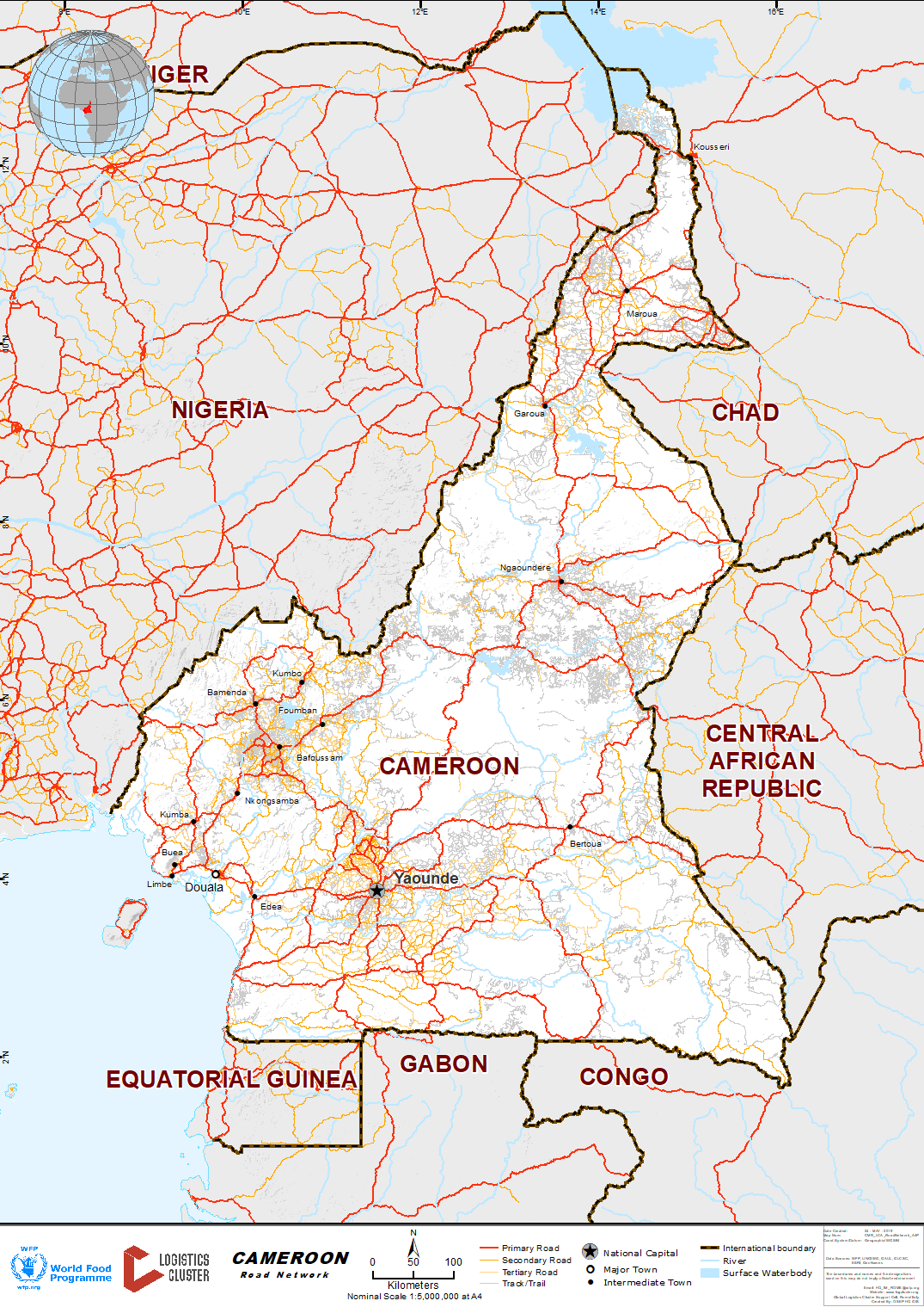
Overview
According to official statistics, there are about 50,000 km of roads in Cameroon, of which 5,000 km are paved. The road network, both paved and unpaved, is poorly maintained.
|
Road |
Distance (km) |
|
|
Cameroon Road Network |
Paved |
5,133 |
|
Unpaved |
12,799 |
|
|
Tracks |
59,657 |
|
|
Total |
77,589 |
|
Classification |
Administering Agency |
Network Length |
|
National Roads |
Road Fund Cameroon |
7041 km |
|
Provincial Roads |
Road Fund Cameroon |
5616 km |
|
Departmental Roads |
Road Fund Cameroon |
8075 km |
|
Rural Roads (classified) |
Road Fund Cameroon |
12843 km |
|
Rural Roads (non-classified) |
Road Fund Cameroon |
16100 km |
The country’s road density is estimated at 7 km for each 1,000 km2. During the wet season, only paved roads remain passable. Traffic on unpaved roads may be restricted by rain barriers. Trucks can therefore be stopped for many hours. On many bridges the traffic of trucks is not allowed. Trucks must use deviations through rivers, but during the rainy season when the waters are high, passing through rivers bank may be impossible.
The Road Fund of Cameroon was created in 1996 in order to implement the government policy on the road sector. Government efforts to improve the state/condition of Cameroonian roads are focused on a network of 27,000 km and the process is being undertaken.
At N’Gaoundere, on the N1 to Garoua, the tarring process is ongoing. On the same road but from Maroua to Kousseri, repairs started in March 2018 are ongoing.
Further road works on the new highway from Kribi to Yaoundé and from Yaoundé airport to the capital were planned but are currently stopped.
The Banque Africaine de Développement (BAD) has provided a loan of 18 million euro in November 2018 for the rehabilitation of a portion of 365 km in North-West, covering five of the seven districts. This portion is part of a 255 million euro project designated to redo the Yaounde-Bafoussam-Bamenda axis. The project is scheduled to run until 2024.
For more information on government contact details, please see the following link: 4.1 Cameroon Government Contact List

Road Security
Cases of carjacking and highway banditry are reportedly frequent, especially on the unpaved road stretches. Military escorts may be required on secondary roads in the northern part of the country.
Axle Load Limits
Vehicles’ payload in Cameroon must not exceed:
- Axle load limits:
- Simple axle : 13 mt
- Double axle : 21 mt
- Triple axle : 27 mt
- Maximum Authorized Load (PTAC): 28 mt maximum axle load authorized.
- Size: width 2.5 m / height 4 m
With the introduction of authorized load legislation and weigh bridges, the maximum tonnage a truck can load is limited to 28 mt. The weight limitation has had an impact on the availability of trucks.
|
Axle load limits |
CAMEROON |
Transit CAR |
Transit CHAD |
|
Truck with 2 axles |
21MT |
21MT |
21MT |
|
Truck with 3 axles |
27MT |
27MT |
27MT |
Bridges
On the paved roads, all bridges are built in concrete material. However, traffic on some of these bridges could be restricted for heavy trucks, especially when there is a risk of collapse.
On unpaved roads, there are some wooden bridges, especially on the ‘West’ road from Douala to Ngaoundéré via Bafoussam. It is advisable to know the state of these bridges before sending trucks from Douala to Ngaoundéré using the ‘West’ road.
Road Class and Surface Conditions
|
Classification |
Road Description |
|
Class: National Roads |
Link the national capital Yaoundé to all 10 provincial capitals. It links also Cameroon to neighbouring countries. |
|
Class: Provincial Roads |
Link, inside the provinces, all division/departmental capitals to the provincial capital. |
|
Class: Departmental Roads |
Link, inside the division/department, all sub-divisions to the departmental capital. |
|
Class: Rural Roads (classified) |
Link main agricultural production areas to main markets in the concerned regions. |
|
Class: Rural Roads (non-classified) |
Managed by development companies or decentralized local collectivises. |
|
Provinces |
Superficie |
population |
Routes |
Routes en |
Routes en |
Routes |
Routes |
Total |
|
Adamaoua |
64 000 |
700 000 |
441 |
1350 |
651 |
605 |
1208 |
4255 |
|
Centre |
69 000 |
2 400 000 |
921 |
1555 |
1532 |
3725 |
3303 |
11036 |
|
Est |
110 000 |
750 000 |
346 |
1590 |
1455 |
868 |
715 |
4974 |
|
Extreme- Nord |
34 000 |
2 650 000 |
589 |
1011 |
1088 |
1195 |
1501 |
5384 |
|
Nord |
66 000 |
1 200 000 |
645 |
1044 |
1084 |
867 |
1147 |
4787 |
|
Littoral |
20 000 |
2 150 000 |
478 |
773 |
302 |
708 |
718 |
2979 |
|
Nord- |
16 000 |
1 800 000 |
205 |
841 |
67 |
1231 |
2160 |
4504 |
|
Sud-Ouest |
25 000 |
1 200 000 |
260 |
942 |
173 |
740 |
876 |
2991 |
|
Ouest |
13 000 |
1 950 000 |
459 |
983 |
355 |
1473 |
1121 |
4391 |
|
Sud |
47 000 |
520 000 |
574 |
1512 |
735 |
698 |
982 |
4501 |
|
TOTAL |
466 000 |
15 292 000 |
4918 |
11601 |
7442 |
12110 |
13731 |
49802 |
Distance Matrix
The distance matrix for the Cameroon Road Network can be found here: Annex 8 - Travel Distances Matrix (English)
Attachment - Travel Distances from Major Towns to Neighbouring Countries
Source: Catalogue Road 2011 published by the Centre de Traitement de l’Information Numérique
Transport corridors
The Douala corridor, used by WFP, other UN agencies and most NGOs, provides the main route for aid commodities ex-Cameroon to CAR and Chad.
CAR
According to the conventions between Cameroon and CAR of December 22nd 1999, legal roads to/from CAR are:
In Cameroon
Roads:
- Douala – Yaoundé – Naga/Eboko – Bertoua – Garoua Boulai
- Douala – Yaoundé – Abong/Mbang – Bertoua – Batouri Kentzou
- Douala – Yaoundé – Bertoua – Batouri Yakadouma Ngoka Border
Combined roads (rail – road):
- Douala – Belabo – Bertoua – Garoua Boulai
- Douala – Belabo – Bertoua – Batouri – Kentzou
- Douala – Nagoundere – Meiganga – Garoua Boulai
In CAR
Roads:
- Bangui – Bouar – Baboua – Beloko
- Bangui – Camot – Berberati – Gamboula
- Bangui – Bossangoa – Pende – N’Dim – Bouar – Beloko
- Nola – Tomori Border
Corridor Douala - CAR
- Check-Point 1 in Yassa (Douala exit)
- Check-Point 2 in Bertoua
- Check-Point 3 Border office in Garoua Boulai at the border (PK0)
with CAR (Beloko Road (PK2) Bouar-Bangui).
- Check-Point 3’ Border office in Bombé (5km of the border (PK0)
with CAR (Gamboula Road (PK30 –Berberati-Bangui).
Chad
According to the conventions between Cameroon and Chad of April 13th, 1999, legal roads to/from Chad are:
In Cameroon
Roads:
- Douala – Yaoundé – Nanga-Eboko – Bertoua – Garoua-Boulai - Meiganga – Ngaoundere – Garoua – Maroua – Kousseri – Border
- Douala – Yaoundé – Abong/Mbang – Bertoua – Garoua-Boulai – Ngaoundere – Garoua – Figuil – Border
- Douala – Yaoundé – Abong/Mbang – Bertoua – Garoua-Boulai – Ngaoundere – Touboro
- Douala – Yaoundé – Abong/Mbang – Bertoua – Garoua-Boulai – Ngaoundal – Border
Combined roads (rail-road):
- Douala – Ngaoundere (rail)
- Ngaoundere – Garoua – Figuil – Border
- Ngaoundere – Garoua – Maroua – Kousseri – Border
- Ngaoundere – Touboro – Border
- Douala – Ngaoundere (rail)
- Ngaoundal – Meiganga – Border
In Chad
Roads:
- Ngueli – Ndjamena
- Lere – Moundou – Sarh
- Larmanaye – Moundou – Sarh
- Gadjibian – Doba – Moundou
Corridor Ngaoundéré - Chad
- Check-Point 1 in Dang (Ngaoundere exit)
- Check-Point 2 inKollé (Figuil north)
- Check-Point 2’ Border office in Delelé (border with Chad)
- Check-Point 3 Border Office in Kousseri (border with Chad and
Ndjamena).
Please see the annexes page at the following link for further information about the overland transport corridors, including information on weight bridges and checkpoints (annex 9) and information on penalties for infractions of timelines and rules for transit cargo (annex 10): 5 Cameroon Annexes
Road from Douala to Ngaoundéré
Ngaoundéré is the final station of the main railways line from Douala Port. Presently, there are two main road corridors from Douala to Ngaoundéré:
- The main road via Garoua-Boulaï at the border with CAR, which is the legal/customs road.
- The road via Bafoussam, also called the ‘west’ road, which should not be used for goods in transit to neighbouring countries, unless prior authorization is obtained from customs.
1) The road from Douala Port to Ngaoundéré via Garoua-Boulaï
|
Location Details |
Origin |
Destination |
|
Town or city (closest) |
Douala |
Ngaoundéré |
|
Total Route (distance in km) |
1,114 |
|
|
Road characteristics (over full distance) |
|||||||||||||
|
|
Jan |
Feb |
Mar |
Apr |
May |
Jun |
Jul |
Aug |
Sep |
Oct |
Nov |
Dec |
|
|
Total route time 4x4 (Days) |
2 |
2 |
2 |
2 |
2 |
2 |
3 |
3 |
3 |
2 |
2 |
2 |
|
|
Passable by (over full distance) |
Car |
Yes |
Yes |
Yes |
Yes |
Yes |
Yes |
Yes |
Yes |
Yes |
Yes |
Yes |
Yes |
|
4X4 |
Yes |
Yes |
Yes |
Yes |
Yes |
Yes |
Yes |
Yes |
Yes |
Yes |
Yes |
Yes |
|
|
Truck (rigid) |
Yes |
Yes |
Yes |
Yes |
Yes |
Yes |
Yes |
Yes |
Yes |
Yes |
Yes |
Yes |
|
|
Trailer |
Yes |
Yes |
Yes |
Yes |
Yes |
Yes |
Yes |
Yes |
Yes |
Yes |
Yes |
Yes |
|
|
Total route time for truck and trailers (Days) |
3 |
3 |
3 |
3 |
3 |
4 |
5 |
5 |
5 |
3 |
3 |
3 |
|
| Note: It should be mentioned that the road is passable at all seasons, although some stretches may be extremely difficult for trucks, especially during the wet season from June to September. | |||||||||||||
|
Stretch 1: From Douala Port to Yaoundé |
|||
|
Distance from origin at start of stretch - km |
0 |
||
|
Distance from origin at end of stretch - km |
267 |
||
|
Route time on this stretch (4X4) – Hours |
3 |
||
|
Town or city (closest) |
Douala |
||
|
Class of road |
Highway |
||
|
Surface |
Asphalt |
||
|
Passable by |
Car, 4X4, Truck and Trailer |
||
The road from Douala Port to Yaoundé is the busiest highway in Cameroon, with many trucks, especially timber trucks.
The road is narrow and accidents are frequent.
The entrance of Douala and Yaoundé is often congested.
|
Stretch 2: From Yaoundé to Ayos |
|||
|
Distance from origin at start of stretch - km |
267 |
||
|
Distance from origin at end of stretch - km |
407 |
||
|
Route time on this stretch (4X4) – Hours |
1.5 |
||
|
Town or city (closest) |
Yaoundé |
||
|
Class of road |
Highway |
||
|
Surface |
Asphalt |
||
|
Passable by |
Car, 4X4, Truck and Trailer |
||
|
Stretch 3: From Ayos to Bertoua |
|||
|
Distance from origin at start of stretch - km |
407 |
||
|
Distance from origin at end of stretch - km |
597 |
||
|
Route time on this stretch (4X4) – Hours |
3.5 |
||
|
Town or city (closest) |
Ayos |
||
|
Class of road |
Highway |
||
|
Surface |
Dirt |
||
| Possible weather conditions | Mud | ||
|
Passable by |
Car, 4X4, Truck and Trailer |
||
| Nature of change to next stretch | Improving - newly built road | ||
|
Stretch 4: From Bertoua to Garoua-Boulaï |
||||||
|
Distance from origin at start of stretch - km |
597 |
|||||
|
Distance from origin at end of stretch - km |
843 |
|||||
|
Route time on this stretch (4X4) – Hours |
2.5 |
|||||
|
Town or city (closest) |
Bertoua |
|||||
|
Class of road |
Highway |
|||||
|
Surface |
Asphalt |
|||||
|
Passable by |
Car, 4X4, Truck and Trailer |
|||||
|
Nature of change to next stretch |
Getting worse |
|||||
| Note: Garoua-Boulaï is the border town with the Central African Republic. | ||||||
|
Stretch 5: From Garoua-Boulaï to Ngaoundéré |
|||||
|
Distance from origin at start of stretch - km |
843 |
||||
|
Distance from origin at end of stretch - km |
1,114 |
||||
|
Route time on this stretch (4X4) – Hours |
5 |
||||
|
Town or city (closest) |
Garoua-Boulaï |
||||
|
Class of road |
Highway |
||||
|
Surface |
Dirt |
||||
|
Possible weather conditions |
Mud |
||||
|
Passable by |
Car, 4X4, Truck and Trailer |
||||
| Note: This stretch of the road was paved recently. It is now good in all seasons. | |||||
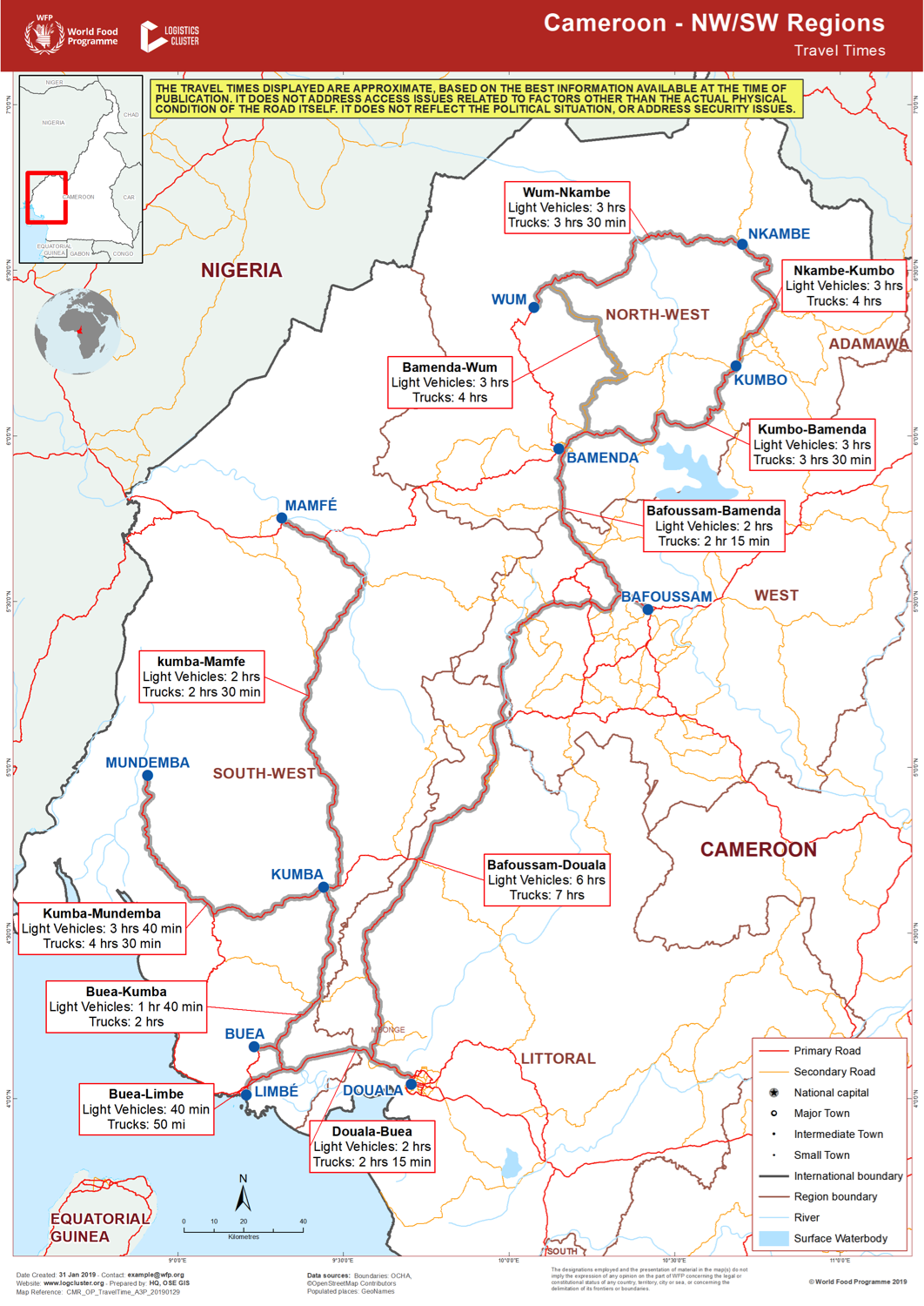
2) The road from Douala Port to Ngaoundéré via Bafoussam (the ‘West’ road)
Organizations sometimes request the authorization of the Customs to use the ‘West’ road up from Douala port to Ngaoundéré. This normally happens during the months of February to May, in view of the upcoming wet season when many roads are closed in that country.
It should be mentioned that Chad-bound cargo from Douala Port should normally be loaded on wagons unless previous authorization.
|
Stretch 1: From Douala Port to Bafoussam |
||||||
|
Distance from origin at start of stretch - km |
0 |
|||||
|
Distance from origin at end of stretch - km |
238 |
|||||
|
Route time on this stretch (4X4) – Hours |
3 |
|||||
|
Town or city (closest) |
Douala |
|||||
|
Class of road |
Highway |
|||||
|
Surface |
Asphalt |
|||||
|
Passable by |
Car, 4X4, Truck and Trailer |
|||||
|
Nature of change to next stretch |
Getting Worse |
|||||
|
Stretch 2: From Bafoussam to Tibati |
||||||
|
Distance from origin at start of stretch - km |
238 |
|||||
|
Distance from origin at end of stretch - km |
636 |
|||||
|
Route time on this stretch (4X4) – Hours |
10 |
|||||
|
Town or city (closest) |
Bafoussam |
|||||
|
Class of road |
Secondary |
|||||
|
Surface |
Dirt |
|||||
|
Possible weather conditions |
Mud, Flooding |
|||||
|
Passable by |
Car, 4X4, Truck and Trailer |
|||||
|
Nature of change to next stretch |
Getting Worse |
|||||
| Note: During the wet season, some parts of this road may be very difficult and even impassable for trucks. There are many rain barriers. | ||||||
|
Stretch 3: From Tibati to Ngaoundéré |
||||||
|
Distance from origin at start of stretch - km |
636 |
|||||
|
Distance from origin at end of stretch - km |
917 |
|||||
|
Route time on this stretch (4X4) – Hours |
7 |
|||||
|
Town or city (closest) |
Tibati |
|||||
|
Class of road |
|
|||||
|
Surface |
Dirt |
|||||
|
Possible weather conditions |
Mud, Flooding |
|||||
|
Passable by |
Car, 4X4, Truck and Trailer |
|||||
|
Nature of change to next stretch |
Restriction - many rain barriers during the rainy season. Heavy trucks should therefore wait until the road becomes sufficiently dried. |
|||||
|
Road Security |
|
|
Security |
Rated as Good |
| It should be mentioned that cases of carjacking and highway banditry are frequent in Cameroon, especially on the unpaved road stretches. | |
Road from Ngaoundéré to Kousseri
Ngaoundéré is the end station of the railroad from Douala Port. The government has established a dry port in this town, as cargo loaded on wagons is transhipped there onto trucks directly to final destinations in northern Cameroon and Chad.
Due to security constraints in the region, the Touboro crossing point is now regularly used instead of Kousseri. Nevertheless this corridor is still active when it comes to carrying local bought products into Chad.
Logistical infrastructures in Ngaoundéré include many warehouses and a container terminal managed by Bollore. More details can be found in page 2.4 Cameroon Railway Assessment.
|
Location Details |
||
|
|
Origin |
Destination |
|
Town or city (closest) |
Ngaoundéré |
Kousseri |
|
Total Route (distance in km) |
750 |
|
|
Road characteristics (over full distance) |
|||||||||||||
|
|
Jan |
Feb |
Mar |
Apr |
May |
Jun |
Jul |
Aug |
Sep |
Oct |
Nov |
Dec |
|
|
Total route time 4x4 (Days) |
1 |
1 |
1 |
1 |
1 |
1 |
1 |
1 |
1 |
1 |
1 |
1 |
|
|
Passable by (over full distance) |
Car |
Yes |
Yes |
Yes |
Yes |
Yes |
Yes |
Yes |
Yes |
Yes |
Yes |
Yes |
Yes |
|
4X4 |
Yes |
Yes |
Yes |
Yes |
Yes |
Yes |
Yes |
Yes |
Yes |
Yes |
Yes |
Yes |
|
|
Truck (rigid) |
Yes |
Yes |
Yes |
Yes |
Yes |
Yes |
Yes |
Yes |
Yes |
Yes |
Yes |
Yes |
|
|
Trailer |
Yes |
Yes |
Yes |
Yes |
Yes |
Yes |
Yes |
Yes |
Yes |
Yes |
Yes |
Yes |
|
|
Total route time for truck and trailers (Days) |
1.5 |
1.5 |
1.5 |
1.5 |
1.5 |
1.5 |
1.5 |
1.5 |
1.5 |
1.5 |
1.5 |
1.5 |
|
|
Stretch 1: From Ngaoundéré to Garoua |
||||||
|
Distance from origin at start of stretch - km |
0 |
|||||
|
Distance from origin at end of stretch - km |
275 |
|||||
|
Route time on this stretch (4X4) – Hours |
3.5 |
|||||
|
Town or city (closest) |
Ngaoundéré |
|||||
|
Class of road |
Highway |
|||||
|
Surface |
Asphalt |
|||||
|
Passable by |
Car, 4X4, Truck and Trailer |
|||||
|
Nature of change to next stretch |
Getting Worse. The road is deteriorating. Rehabilitation works are planned by the government. |
|||||
|
Stretch 2: From Garoua to Maroua |
||||||
|
Distance from origin at start of stretch - km |
275 |
|||||
|
Distance from origin at end of stretch - km |
484 |
|||||
|
Route time on this stretch (4X4) – Hours |
3 |
|||||
|
Town or city (closest) |
Garoua |
|||||
|
Class of road |
Highway |
|||||
|
Surface |
Asphalt |
|||||
|
Passable by |
Car, 4X4, Truck and Trailer |
|||||
|
Nature of change to next stretch |
Improving |
|||||
| The road is newly rehabilitated from the beginning to the end. All bridges are concrete | ||||||
|
Stretch 3: From Maroua to Kousseri |
||||||
|
Distance from origin at start of stretch - km |
484 |
|||||
|
Distance from origin at end of stretch - km |
750 |
|||||
|
Route time on this stretch (4X4) – Hours |
3 |
|||||
|
Town or city (closest) |
Maroua |
|||||
|
Class of road |
Highway |
|||||
|
Surface |
Asphalt |
|||||
|
Passable by |
Car, 4X4, Truck and Trailer |
|||||
|
Nature of change to next stretch |
Getting Worse |
|||||
| Note: Maintenance work are under process on road N1 from Maroua to Kousseri. If the portion Maroua-Mora should be completed within the next few weeks, the remaining part between Mora and Kousseri seems in stand-by. It currently affect time travel to N’Djamena. | ||||||
Road from Ngaoundéré to Touboro
As noted above this route is now used partially instead of the Kousseri border route.
|
Location Details |
||
|
|
Origin |
Destination |
|
Town or city (closest) |
Ngaoundéré |
Touboro / Bogdibo |
|
Total Route (distance in km) |
280 |
|
|
Road characteristics (over full distance) |
|||||||||||||
|
|
Jan |
Feb |
Mar |
Apr |
May |
Jun |
Jul |
Aug |
Sep |
Oct |
Nov |
Dec |
|
|
Total route time 4x4 (Days) |
1 |
1 |
1 |
1 |
1 |
1 |
1 |
1 |
1 |
1 |
1 |
1 |
|
|
Passable by (over full distance) |
Car |
Yes |
Yes |
Yes |
Yes |
Yes |
Yes |
Yes |
Yes |
Yes |
Yes |
Yes |
Yes |
|
4X4 |
Yes |
Yes |
Yes |
Yes |
Yes |
Yes |
Yes |
Yes |
Yes |
Yes |
Yes |
Yes |
|
|
Truck (rigid) |
Yes |
Yes |
Yes |
Yes |
Yes |
Yes |
Yes |
Yes |
Yes |
Yes |
Yes |
Yes |
|
|
Trailer |
Yes |
Yes |
Yes |
Yes |
Yes |
Yes |
Yes |
Yes |
Yes |
Yes |
Yes |
Yes |
|
|
Total route time for truck and trailers (Days) |
1 |
1 |
1 |
1 |
1 |
1 |
1 |
1 |
1 |
1 |
1 |
1 |
|
|
Stretch 1: From Ngaoundéré to Garoua |
||||||
|
Distance from origin at start of stretch - km |
0 |
|||||
|
Distance from origin at end of stretch - km |
280 |
|||||
|
Route time on this stretch (4X4) – Hours |
4 |
|||||
|
Town or city (closest) |
Ngaoundéré |
|||||
|
Class of road |
Highway |
|||||
|
Surface |
Asphalt |
|||||
|
Passable by |
Car, 4X4, Truck and Trailer |
|||||
|
Nature of change to next stretch |
Getting Worse. The road is deteriorating. Rehabilitation works are planned by the government. |
|||||
|
Road Security |
|
|
Security |
The security level in this stretch is 2. |
| Traffic of trucks is high on this road. | |
2.3.1 Cameroon Border Crossing of Touboro (Chad border)
Due to security constraints on the north corridor, the Touboro crossing is being used partially in place of the Kousseri entry point. The distances on the route are:
- Ngaoundéré to Touboro (Cameroonian territory - 280 km);
- Touboro to Bogdibo (Cameroon border town with Chad) 25 km;
- Koutere (first border town in Chadian territory) – Moundou 110 km;
- Moundou - Ndjamena 490 km.
|
BORDER CROSSING LOCATION & CONTACT |
|
|
Name of Border Crossing: |
Touboro / Bogdibo Entry Point |
|
Province or District: |
North Province / Touboro |
|
Nearest Town or City: (Nearest location with distance from port) |
Touboro 25 km |
|
Latitude: |
07°46’06.80’’ N |
|
Longitude: |
15°20’46.90’’ E |
|
Managing Authority/Agency: |
Cameroon Customs Authority |
|
Contact Person |
Chef de bureau Douanes Touboro: Henri Boza Toutou (+237 662 942 496 Customs Controller at Bogdibo: Penn Donald Mofor |
|
Travel Times |
|
|
Nearest International Airport: |
Ngaoundéré - 280km Truck: 1 day. Car: half day. |
|
Nearest Port: |
Ngaoundéré Dry-Port - 280km Truck: 1 day Car: half day |
|
Nearest Major Market: |
Ngaoundéré Dry-Port - 280km Truck: 1 days Car: half day |
|
Hours of Operation |
|
|
MONDAYS |
From 07H30 – 15H30 (nonstop work) |
|
TUESDAYS |
From 07H30 – 15H30 (nonstop work) |
|
WEDNESDAYS |
From 07H30 – 15H30 (nonstop work |
|
THURSDAYS |
From 07H00 – 15H30 (nonstop work) |
|
FRIDAYS |
From 07H00 – 15H30 (nonstop work) |
|
SATURDAYS |
Closed |
|
SUNDAYS |
Closed |
|
NATIONAL HOLIDAYS: |
1 January, 11 February, 20 May, 25 December, etc. |
|
SEASONAL CONSTRAINTS: |
None |
2.3.2 Cameroon Border Crossing of Kousseri (Chad border)
Overview
This was the usual corridor to Chard prior to recent insecurity. The Touboro crossing point has now partially replaced it as the usual corridor.
Note: There is no escort requirement on this axe anymore. But daily patrols are done by multinational and national forces to ensure security of the road. Furthermore, truck drivers prefer to travel in convoy in case of incidents.
|
Border Crossing Location and Contact |
|
|---|---|
|
Name of Border Crossing |
Kousseri Entry Point |
|
Province or District |
Far North Province / Kousseri |
|
Nearest Town or City with Distance from Border Crossing |
Maroua 224km |
|
Latitude |
12 05’12.60’’ N |
|
Longitude |
15 00’52.74’’ E |
|
Managing Authority / Agency |
Cameroon Customs Authority |
|
Contact Person |
Mr Bidje Celestin, Head Customs Far-North Mob: (+237) 699 575 589 |
|
Travel Times |
|
|---|---|
|
Nearest International Airport |
Maroua 224km Truck Travel Time: Planned the whole day, due to poor road |
|
Nearest Port |
Ngaoundéré Dry-Port |
|
Nearest location with functioning wholesale markets, or with significant manufacturing or production capacity |
Garoua, Maroua 435km, 224 km Truck Travel Time: 2 days from Garoua |
|
Hours of Operation |
|
|---|---|
|
Mondays |
From 07H30 – 15H30 (nonstop work) |
|
Tuesdays |
From 07H30 – 15H30 (nonstop work) |
|
Wednesdays |
From 07H30 – 15H30 (nonstop work) |
|
Thursdays |
From 07H30 – 15H30 (nonstop work) |
|
Fridays |
From 07H30 – 15H30 (nonstop work) |
|
Saturdays |
Closed |
|
Sundays |
Closed |
|
National Holidays |
1 January, 11 February, 20 May, 25 December, etc. |
|
Seasonal Constraints |
Rainy reason (June to September) as the road is poorly maintained. |
Customs Clearance
For more information on customs in Cameroon, please see the following link: 1.3 Cameroon Customs Information
Other Relevant Information
Information can be obtained from the following sources:
- Ministry of Territorial Administration and Decentralization
For more information on government contact details, please see the following link: 4.1 Cameroon Government Contact List
Cameroon - 2.3.3 Cameroon Border Crossing of Garoua-Boulaï (CentralAfrican Republic border)
Garoua-Boulaï is the border town with the Central African Republic. At time of writing, there is no need for escort, although cases of armed banditry, without any casualties, are reported in the area near the border check point during the end of year’s festivities. Many check points are installed along the road by the national forces (Gendarmerie, Police and Custom).
The road is well done, though there are continuous bends throughout the 597km of distance and traffic of heavy trucks is dense.
|
Border Crossing Location and Contact |
|
|---|---|
|
Name of Border Crossing |
Garoua-Boulai Entry Point |
|
Province or District |
East Province / Garoua-Boulai |
|
Nearest Town or City with Distance from Border Crossing |
Bertoua 252km |
|
Latitude |
05 53’25.67’’ N |
|
Longitude |
14 32’52.37’’ E |
|
Managing Authority / Agency |
Cameroon Customs Authority |
|
Travel Times |
|
|---|---|
|
Nearest International Airport |
Yaoundé - 588km Truck: 12Hrs Car: 5Hrs |
|
Nearest Port |
Douala Port - 823km Truck: 1 day Car: 9hrs |
|
Nearest location with functioning wholesale markets, or with significant manufacturing or production capacity |
Bertoua, Yaoundé 588km and 252km Truck: 1 day Car: 9hrs |
|
Hours of Operation |
|
|---|---|
|
Mondays |
From 07H30 – 15H30 (nonstop work) |
|
Tuesdays |
From 07H30 – 15H30 (nonstop work) |
|
Wednesdays |
From 07H30 – 15H30 (nonstop work) |
|
Thursdays |
From 07H30 – 15H30 (nonstop work) |
|
Fridays |
From 07H30 – 15H30 (nonstop work) |
|
Saturdays |
Closed |
|
Sundays |
Closed |
|
National Holidays |
1 January, 11 February, 20 May, 25 December, etc. |
|
Seasonal Constraints |
N/A The road is good from the port of Douala to Garoua-Boulaî |
2.3.4 Cameroon Border Crossing of Bitam (Gabon border)
Bitam is the end station of the road 25 km away from the town of Ambam. Customs authorities and security corps (Gendarmerie and Police) have offices which are functioning 7 days a week from 07H00 to 18H00. Many check points are open on the way. Most of the trucks crossing the border contain mainly food produced in Cameroon to supply the markets of Gabon. Passenger transport by Cameroonian cars or bus is not allowed to enter in Gabon.
Only the Gabonese public transport is allowed to cross the border with passengers in respect to the Gabonese immigration law. Any logistical activities other than trucks delivering food to Gabon are not available. There are not fuel stations between Ambam to Bitam border entry point to the Republic of Gabon.
|
Border Crossing Location and Contact |
|
|---|---|
|
Name of Border Crossing |
Bitam Entry Point |
|
Province or District |
South Region / Bitam |
|
Nearest Town or City with Distance from Border Crossing |
Ebolowa - 139km |
|
Latitude |
02 04’40.11’’ N |
|
Longitude |
11 29’40.26’’ E |
|
Managing Authority / Agency |
Cameroon Customs Authority |
|
Travel Times |
|
|---|---|
|
Nearest International Airport |
Yaoundé Truck Travel Times: 8 Hours Car Travel Times: 4 Hours |
|
Nearest Port |
Douala Port or Kribi Port Truck Travel Times: 1 day Car Travel Times: 8 Hours |
|
Hours of Operation |
|
|---|---|
|
Mondays |
From 07H30 – 15H30 (nonstop work) |
|
Tuesdays |
From 07H30 – 15H30 (nonstop work) |
|
Wednesdays |
From 07H30 – 15H30 (nonstop work) |
|
Thursdays |
From 07H30 – 15H30 (nonstop work) |
|
Fridays |
From 07H30 – 15H30 (nonstop work) |
|
Saturdays |
Closed |
|
Sundays |
Closed |
|
National Holidays |
1 January, 11 February, 20 May, 25 December, etc. |
|
Seasonal Constraints |
|
Customs Clearance
For more information on customs in Cameroon, please see the following link: 1.3 Cameroon Customs Information
Other Relevant Information
For more information on government contact details, please see the following link: 4.1 Cameroon Government Contact List
Cameroon - 2.3.5 Cameroon Border Crossing of Kye-Ossi (Gabon andEquatorial Guinea borders)
Overview
Kye-Ossi is the end station of the road 38 km away from the town of Ambam. Customs authorities and security corps (Gendarmerie and Police) have offices which are functioning 7 days a week from 07H00 to 18H00. Many check points are open on the way. Most of the trucks crossing the border contain mainly food produced in Cameroon to supply the markets of Equatorial Guinea.
Transport vehicles for passengers between Cameroon and Equatorial Guinea are not allowed to cross the border on both side. From the side of Cameroon passengers are required to cross by foot with their effects, usually local food products to take the vehicles waiting in the Guinea landscaped parking. Concerning Cameroonian trucks transporting food products to supply the Guinean market, there isn’t any restriction after the payment of the CEMAC Circulation Certificate.
|
Border Crossing Location and Contact |
|
|---|---|
|
Name of Border Crossing |
Kye-Ossi Entry Point |
|
Province or District |
South Region /Bitam and Kye-Ossi |
|
Nearest Town or City with Distance from Border Crossing |
Ebolowa and Yaoundé |
|
Latitude |
02°10’18.68’’ N |
|
Longitude |
11°20’36.01’’ E |
|
Managing Authority / Agency |
Cameroon Customs Authority |
|
Travel Times |
|
|---|---|
|
Nearest International Airport |
Yaoundé Truck travel time: 8 hrs |
|
Nearest Port |
Douala Truck Travel Time: 1 day |
|
Nearest location with functioning wholesale markets, or with significant manufacturing or production capacity |
Yaoundé, Ebolowa |
|
Hours of Operation |
|
|---|---|
|
Mondays |
From 07H30 – 15H30 (nonstop work) |
|
Tuesdays |
From 07H30 – 15H30 (nonstop work) |
|
Wednesdays |
From 07H30 – 15H30 (nonstop work) |
|
Thursdays |
From 07H30 – 15H30 (nonstop work) |
|
Fridays |
From 07H30 – 15H30 (nonstop work) |
|
Saturdays |
Closed |
|
Sundays |
Closed |
|
National Holidays |
1 January, 11 February, 20 May, 25 December, etc. |
|
Seasonal Constraints |
No constraints. The road is good from Douala to Kye-Ossi |
Customs Clearance
For more information on customs in Cameroon, please see the following link: 1.3 Cameroon Customs Information
Other Relevant Information
For more information on government contact details, please see the following link: 4.1 Cameroon Government Contact List
Cameroon - 2.3.6 Cameroon Border Crossing of Mora-Amchide (Nigeriaborder)
This road cannot be used during raining season from June to October.
|
BORDER CROSSING LOCATION & CONTACT |
|
|
Name of Border Crossing: |
Amchide Entry Point. |
|
Province or District: |
Far North Region / Mora |
|
Nearest Town or City: |
Mora - 30km |
|
Latitude: |
11°02’24.45’’ N |
|
Longitude: |
14°09’09.54’’ E |
|
Managing Authority/Agency: |
Cameroon Customs Authority |
|
Contact Person |
Mr Bidje Celestin, Chief Customs Far-North Mob: (+237) 699 575 589 |
|
Travel Times |
|
|
Nearest International Airport: |
Maroua - 104km Truck: Planned 2 days, due to poor road. Car: At least 20 hrs, due to poor road |
|
Nearest Port: |
Ngaoundéré Dry Port - 557km Truck: 5 days at minimum Car: 4 days |
|
Nearest Major Market: |
Maroua - 104km Truck: Planned 2 days, due to poor road. Car: At least 20 Hrs, due to poor road |
|
Hours of Operation |
|
|
MONDAYS |
From 07H30 – 15H30 (nonstop work) |
|
TUESDAYS |
From 07H30 – 15H30 (nonstop work) |
|
WEDNESDAYS |
From 07H30 – 15H30 (nonstop work) |
|
THURSDAYS |
From 07H30 – 15H30 (nonstop work) |
|
FRIDAYS |
From 07H30 – 15H30 (nonstop work) |
|
SATURDAYS |
Closed |
|
SUNDAYS |
Closed |
|
NATIONAL HOLIDAYS: |
1 January, 11 February, 20 May, 25 December, etc. |