2 Belize Logistics Infrastructure
Despite notable progress in the last decade, the extent and quality of transport infrastructure in Belize still lags behind other countries in the Latin American and Caribbean (LAC) region (IDB, 2013). Connectivity with neighboring countries in Central America such as Guatemala and Mexico is limited. Moreover, access to extensive areas of land in the country’s interior is impeded, particularly in the South and during the rainy season.
Belize's road network is 3,281 km long and requires adequate routine and periodic maintenance to keep it in a stable, durable condition, particularly due to the country’s vulnerability to natural disasters.
The National Sustainable Tourism Plan (NSTMP) of Belize 2030 addresses the need for transportation infrastructure improvements, such as for highways and roads, increasing regional and international airport safety and capacity and upgrading seaport and pier facilities.
2.1 Belize Port Assessment

There are two primary ports, both of which are privately owned: Port of Belize City, owned by Port of Belize Limited, and Port of Big Creek, owned by the Big Creek Group. The port in Belize City is primarily a container port, while the Big Creek port concentrates more on agricultural products (bananas, fruit concentrates, sugar, etc.) and bulk cargo. Both ports have limitations with draught and berthing, and limited loading and unloading capacity. A third port, the port at Harvest Caye is a private port, dedicated exclusively to cruise ships.
2.1.1 Belize Port of Belize
Port Overview
The Port of Belize City was originally established in 1978. In 2002, the government of Belize agreed to sell the Port of Belize to Port of Belize Limited (PBL), including the license to operate, manage and provide port-related services. The license was granted for a duration of 30 years and sets out the specific responsibilities and duties of PBL. More recently , discussions between PBL and the government of Belize are ongoing to modernize the port facilities by constructing a new bulk terminal to serve the growing needs of the export sector.
Port website: Port of Belize Website
Key port information may also be found at http://www.maritime-database.com
|
Port Location and Contact |
|
|---|---|
|
Country |
Belize |
|
Province or District |
Belize |
|
Nearest Town or City with Distance from Port |
Belize City (0.5 km) |
|
Port's Complete Name |
Port of Belize |
|
Latitude |
17.47368 |
|
Longitude |
-88.20073 |
|
Managing Company or Port Authority |
Port of Belize Limited |
|
Management Contact Person |
Kenrick M. Rirchards /Cargo Operations Manager |
|
Nearest Airport and Airlines with Frequent International Arrivals/Departures |
Airport Name: Philip Goldson International Airport Belize Airlines: United, American, Delta, Southwest and Avianca |
Port Picture
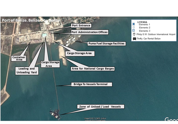
- Port Entrance from Belize City
- Puma Fuel Storage Facilities (Fuel Supplier for Belize) - 189,270 litre (50,000 gallons) storage capacity
- Storage Warehouse 1,950 m2
- Loading/Unloading Areas 2,400 m2 and 790 m2
- Pier Length to Dock (+/- 700 meters)
- Containers Yards 9,290 m2 and 5,850 m2
Description and Contacts of Key Companies
For more information on key companies at the Port of Belize City, see the following link:4.4 Belize Port and Waterways Companies Contact List
Port Performance
The Port of Belize City faces several access constraints and bottlenecks. The one lane trestle and pier head create a severe bottleneck due to its small size and sharp turning angles. As a result, this leads to limited movement and activity on the pier head itself. Likewise, the width of the pier head restricts vessel operations to one at a time, and restricts efficient use of either shore cranes or ship cranes. This adds significant costs to the port's operations.
The shallow depths in the channel, turning basin and pier head restrict the size of vessels that can operate at the port, while restricting the possibility of economies of scale, in particular for bulk commodities. The substandard design and condition of crane equipment at the pier head causes bottlenecks and additional costs, in particular with wider and larger vessels, resulting in excessive re-shifting and sorting of containers.
|
Seasonal Constraints |
||
|---|---|---|
|
Occurs |
Time Frame |
|
|
Rainy Season |
Yes |
June to November |
|
Major Import Campaigns |
Yes |
March to December |
|
Other Comments |
N/A |
|
|
Handling Figures for 2016 |
|
|---|---|
|
Vessel Calls |
201 |
|
Container Traffic (TEUs) |
46,040 |
|
Handling Figures Bulk and Break Bulk for 2016 |
|
|---|---|
|
Bulk (MT) |
910,805 |
|
Break bulk (MT) |
730,300 |
Berthing Specifications
|
Type of Berth |
Quantity |
Length (m) |
Maximum Draft (m) |
|---|---|---|---|
|
Conventional Berth |
1 |
25 |
8 |
|
Container Berth |
1 |
25 |
8 |
|
Silo Berth |
N/A | ||
|
Berthing Tugs |
1 |
8 |
|
|
Water Barges |
1 |
8 |
General Cargo Handling Berths
|
Cargo Type |
Berth Identification |
|---|---|
|
Imports - Bagged Cargo |
1st Berth |
|
Exports - Bagged Cargo |
1st Berth |
|
Imports and Exports - RoRo |
N/A |
|
Other Imports |
N/A |
Port Handling Equipment
In 2002, the port of Belize was privatized and has been managed by Port of Belize Limited since then.
|
Equipment |
Available |
Total Quantity and Capacity Available |
Comments on Current Condition and Actual Usage |
|---|---|---|---|
|
Dockside Crane |
Yes |
150 mt, 155 mt |
Operational |
|
Container Gantries |
Yes |
Operational |
|
|
Mobile Cranes |
Yes |
55 mt, 60 mt |
Operational |
|
Reachstacker |
Yes |
49.5 mt |
Operational |
|
RoRo Tugmaster (with Trailer) |
No |
||
|
Grain Elevator with Bagging Machines |
No |
||
|
Transtainer |
No |
50 mt, 25 mt |
Operational |
|
Forklifts |
Yes |
5 mt |
Operational |
Container Facilities
|
Facilities |
20 ft |
40 ft |
|---|---|---|
|
Container Facilities Available |
9290 m² |
5850 m² |
|
Container Freight Station (CFS) |
1 |
1 |
|
Refrigerated Container Stations |
72 |
|
|
Other Capacity Details |
N/A |
N/A |
|
Daily Take Off Capacity |
N/A |
N/A |
|
Number of Reefer Stations |
12 |
12 |
|
Emergency Take-off Capacity |
N/A |
N/A |
|
Off take Capacity of Gang Shift |
N/A |
N/A |
Customs Guidance
All documentation needs to be put online which can be done from anywhere in the country. All duties are paid to the Bank Care of Government of Belize. Customs declaration are then taken to the customs office. It takes about one hour to complete the procedures. Working hours of customs offices are from Monday to Friday, 08:00 to 17:00. On weekends, appointments need to be coordinated individually.
For more information on customs in Belize, please see the following link: 1.3 Belize Customs Information
Terminal Information
Multipurpose Terminal
Quay of 67 m and RoRo Berth of 25 m. Pier (230 m² (2,500 ft²)) is currently not in use. The RoRo ramp was never operational due to design flaws and due to a lack of water depth for RoRo vessels on the windward side of the pier head.
Grain And Bulk Handling
Break bulk cargo is being discharged by using vessel cranes. The Port of Belize Limited conducts all these operations. There is no bulk handling facility in Belize to meet the growing need for bulk commodity movements.
Main Storage Terminal
The size of the working area of the port is 2,400 m² (25,800 ft²). The storage warehouses have a total capacity of 1,950 m² (21,000 ft²). Two container yards are available, one of 9,290 m² (100,000 ft²) and of 5,850 m² (63,000 ft²)
|
Storage Type |
Number of Storage Facilities |
Area (m2) |
|---|---|---|
|
Bagged Cargo |
0 |
N/A |
|
Refrigerated Cargo |
1 |
72 Containers |
|
General Cargo |
1 |
Stevedoring
Port services provided by the Port of Belize Limited include the following:
- 24-hour Port Operation
- Pilotage
- Heavy Lift (crane)
- Storage
- Loading and Unloading
- Stripping of Containers
- Re-stuffing of Containers
- 24 Reefer Plugs for Reefer Container
- Warehouse for Cargo Consolidation
- Receiving and Delivery of Cargo/Containers
- Rental of Property (24-hour security)
Hinterland Information
Containers can be loaded on trucks chassis/flatbeds by container handles/crane to move cargo along the Belize road network.
Port Security
The port operates under ISPS level 1. Most of the port areas are kept under 24-hour surveillance by cameras. Additionally, all port facilities are watched by security guards.
|
Security |
|
|---|---|
|
ISPS Compliant |
Yes |
|
Current ISPS Level |
Level 1 |
|
Police Boats |
Yes (Belize Coast Guard) |
|
Fire Engines |
Yes |
Disclaimer: Inclusion of company information in the LCA does not imply any business relationship between the supplier and WFP / Logistics Cluster, and is used solely as a determinant of services, and capacities.
Please note: WFP / Logistics Cluster maintain complete impartiality and are not in a position to endorse, comment on any company's suitability as a reputable service provider.
2.1.2 Belize Port of Big Creek
Port Overview
The Port of Big Creek is located in the south of Belize and is owned and managed by Banana Enterprises Limited (BEL). Its principal activities are tug and barge services, property rental, stevedoring, ship agency, port services, and fertilizer and agro-chemical imports. BEL contracts and provides its own pilot and security services.
The port was established in 1990 to facilitate the export of bananas. Today, mainly bananas, citrus and crude oil are exported through the Port of Big Creek. It is fully equipped and has a cold storage facility with a 24-hour standby power supply. The Big Creek Port is the first privately-owned port in Belize where the vessels are docked alongside the mainland.
Port website: Port of Big Creek Website
Key port information may also be found at http://www.maritime-database.com
|
Port Location and Contact |
|
|---|---|
|
Country |
Belize |
|
Province or District |
Stann Creek |
|
Nearest Town or City With Distance From Port |
Dangrai 87 km |
|
Port's Complete Name |
The Port of Big Creek |
|
Latitude |
16.51416667 |
|
Longitude |
-88.40444444 |
|
Managing Company or Port Authority |
Banana Enterprises Limited |
|
Management Contact Person |
Mr. Gustavo Carrillo |
|
Nearest Airport and Airlines with Frequent International Arrivals/Departures |
Airport Name: Philip Goldson International Airport Belize Airlines: United, American, Delta, Southwest and Avianca |
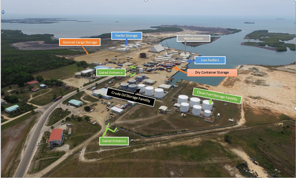
Port Picture
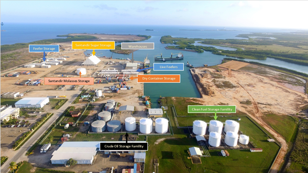
The facilities cover an area of 30 acres including:
- 10.7 acre (~) container yard (1,200 TEUs)
- 12 acre (~) break-bulk terminal
- 59,000 barrel liquid bulk storage area (14 tanks)
- 1,603 m² warehouse (palletized bananas)
- 762.42 m² warehouse (palletized banana boxes)
- 890 m² warehouse (fertilizer and petrochemicals)
- 669 m² warehouse (fertilizer and petrochemicals)
Description and Contacts of Key Companies
For more information on port contacts, please see the following link: 4.4 Belize Port and Waterways Companies Contact List
Port Performance
The Port of Big Creek is fully equipped with a backup power supply to handle refrigerated containers, break bulk cargo, grain and dry containers.
|
Seasonal Constraints |
||
|---|---|---|
|
Occurs |
Time Frame |
|
|
Rainy Season |
Yes |
June to November |
|
Major Import Campaigns |
Yes |
March to December |
|
Other Comments |
N/A |
|
|
Handling Figures for 2016 |
|
|---|---|
|
Vessel Calls |
138 |
|
Container Traffic (TEUs) |
6,634 |
|
Handling Figures Bulk and Break Bulk for 2016 |
|
|---|---|
|
Bulk (MT) |
48,308 |
|
Break bulk (MT) |
43,266 |
Discharge Rates and Terminal Handling Charges
For information on port rates and charges, please see the following link: Belize Port Tariffs.
Berthing Specifications
|
Type of Berth |
Quantity |
Length (m) |
Maximum Draft (m) |
|
Conventional Berth |
1 & 2 |
305 |
6.5 |
|
Container Berth |
3 |
213 |
6.5 |
|
Silo Berth |
N/A |
||
|
Berthing Tugs |
1 |
N/A |
6.5 |
|
Water Barges |
1 |
N/A |
6.5 |
The channel has been dredged to a minimum depth of 7 m for the first 1.5 km and thereafter to a minimum of 6.7 m. A channel width of 67 m has been created at the fully dredged depth to permit single-way ship movements. Maximum vessel LOA is 155 m and maximum safe draft is 6.5 m.
Efforts are ongoing to dredge the existing channel and widen the turning basin area. The turning area will then be able to accommodate a vessel of 250 m. The channel will dredge to a minimum depth of 11 m and a width of 105 m.
General Cargo Handling Berths
|
Cargo Type |
Berth Identification |
|
Imports - Bagged Cargo |
2nd Berth |
|
Exports - Bagged Cargo |
2nd Berth |
|
Imports and Exports - RoRo |
3nd Berth |
|
Other Imports |
N/A |
Port Handling Equipment
The port is privately owned and managed by Banana Enterprises Limited.
|
Equipment |
Available |
Total Quantity and Capacity Available |
|
Dockside Crane |
Yes |
200 mt |
|
Container Gantries |
No |
|
|
Mobile Cranes |
Yes |
60 mt, 110 mt, 200 mt |
|
Reachstacker |
Yes |
32 mt |
|
RoRo Tugmaster (with Trailer) |
No |
|
|
Grain Elevator with Bagging Machines |
No |
|
|
Transtainer |
No |
|
|
Forklifts |
Yes |
5 mt, 3 mt |
Container Facilities
|
Facilities |
20 ft |
40 ft |
|
Container Facilities Available |
8,000 |
4,000 |
|
Container Freight Station (CFS) |
1 |
1 |
|
Refrigerated Container Stations |
120 |
120 |
|
Other Capacity Details |
N/A |
N/A |
|
Daily Take Off Capacity |
N/A |
N/A |
|
Number of Reefer Stations |
3 |
3 |
|
Emergency Take-off Capacity |
N/A |
N/A |
|
Off take Capacity of Gang Shift |
N/A |
N/A |
Customs Guidance
All documentation need to be put online which can be done from anywhere in country. All duties are paid to the Bank Care of Government of Belize. Customs declaration are then taken to the customs office. It takes about 1 hour to complete the procedures. Working hours of customs offices are from Monday to Friday, 08:00 to 17:00, on weekends, on call.
For more information on customs in Belize, please see the following link: 1.3 Belize Customs Information.
Terminal Information
Multipurpose Terminal
Two berths (1 and 2) of a total length of 305 m with a depth of 10 meters. As of September 2017, a third berth of 213 m with a depth of 10 m is under construction.
Grain And Bulk Handling
Facilities to handle grain and break bulk cargo are available. Conveyors from shore to vessels can load grain cargo. Break bulk cargo is discharged by vessel cranes.
Main Storage Terminal
List of available storage facilities:
- 59,000 barrels for liquid bulk cargo (clean fuel)
- 59,000 barrels for liquid bulk cargo (crude oil)
- 1,603 m² warehouse (palletized bananas)
- 762.42 m² warehouse (palletized banana boxes)
- 890 m² warehouse (fertilizer and petrochemicals)
- 669 m² warehouse (fertilizer and petrochemicals)
|
Storage Type |
Number of Storage Facilities |
Area (m2) |
|---|---|---|
|
Bagged Cargo |
NIL |
N/A |
|
Refrigerated Cargo |
1 |
120 plugs |
|
General Cargo |
1 |
Stevedoring
As of today, Banana Enterprises Limited manages over 60 stevedores at the Port of Big Creek.
Hinterland Information
Containers are loaded on trucks chassis/flatbeds by container handles/crane. Those trucks move cargo along the Belize road network.
Port Security
The port is operating under ISPS level 1. The port areas are under 24-hour surveillance by cameras. Additionally, security guards patrol around the port compound (inside and outside).
|
Security |
|
|---|---|
|
ISPS Compliant |
Yes |
|
Current ISPS Level |
Level 1 |
|
Police Boats |
Yes (Coast Guards) |
|
Fire Engines |
Yes |
Disclaimer: Inclusion of company information in the LCA does not imply any business relationship between the supplier and WFP / Logistics Cluster, and is used solely as a determinant of services, and capacities.
Please note: WFP / Logistics Cluster maintain complete impartiality and are not in a position to endorse, comment on any company's suitability as a reputable service provider.
2.2 Belize Aviation

Key airport information may also be found at: http://worldaerodata.com/
The Department of Civil Aviation is the regulatory and oversight body in all civil aviation matters in Belize. The Director of Civil Aviation as established in the Belize Civil Aviation Act heads this Department. He or she is responsible for all civil aviation matters in the country. The main functions of the Department are to ensure the safety of air navigation and to promote and encourage the safe, orderly and economic development of civil aviation locally, regionally and internationally.
For more information on government agency and airport company contact information, please see the following links:
4.1 Belize Government Contact List
4.5 Belize Airport Companies Contact List
Procedures for Foreign Registered Aircraft
Entry requirements and permits for Belize
The following is extracted from the Belize Aeronautical Information Publication (AIP), Gen 1.2, Entry, Transit And Departure of Aircraft:
1. GENERAL
1.1 All flights into, from or over the territory of Belize and landing in such territory shall be carried out in accordance with the Belize Civil Aviation Regulations in force.
1.2 Aircraft landing in or departing from the territory of Belize must first land at or finally depart from the Philip S.W. Goldson International Airport. ICAO Location Indicator MZBZ.
1.3 The intent to enter Belize must be a written request addressed to the Director of Civil Aviation detailing flight itinerary (ies), statement if aircraft desires to conduct internal flights and the area which flights are intended and purpose of the visit. Request or application can be sent via fax to (501) 225-2533 or to contact details appearing on the website: www.civilaviation.gov.bz
2. SCHEDULED FLIGHTS
2.1 GENERAL
2.1.1 For international scheduled flights operated by foreign airlines, applications shall be made to the Air Transport Licensing Authority (ATLA) in writing using the following address:
Air Transport Licensing Authority
c/o Director of Civil Aviation
Department of Civil Aviation
P.O. Box 367
Belize City, Belize
2.1.2 Applications should be accompanied by authenticated copies of Air Operators Certificates and Licenses or Permits to operate Public Transport Services issued by the Country of Registry and Copies of Insurance Certificates covering liability for carriage of passengers, luggage and freight and damage to Third Parties for the territory of Belize. These operators are required to appoint a Ground-Handling agent in Belize.
2.1.3 Applications for Charter Permits, should be sent to the Director of Civil Aviation at least 48 hours in advance, and must contain the following information:
- Name and Address of Operator
- Air carrier Operating Certificate (AOC)
- Type of Aircraft
- Nationality and Registration Marks
- Name of Pilot-in-Command
- Point of Origin and Destination
- Number of Passengers and/or Weight and Type of Cargo
- Name of Consignee (Cargo Flights)
- Purpose of Visit
- Proposed Dates and Times of Arrivals and Departures in Belize
- Route
- Name of Handling Agent (Compulsory)
Applications may be made by AFS to MZBZYAYX or by telefax on (501) 225-2533 or by e-mail to bzeais@yahoo.com or gtorres@civilaviation.gov.bz. The pertinent form appears on the website in FORMS.
Documentary requirements for clearance of aircraft
2.1.4 It is necessary that under mentioned aircraft documents be submitted by airline operators for clearance on entry or departure of their aircraft to and from Belize. All documents listed below must follow the ICAO standard format as set forth in the relevant appendices to ICAO Annex 9 (Facilitation) and are acceptable when furnished in English or Spanish and completed in legible writing.
2.1.5 Aircraft documents required (arrival/departure) TOTAL OF NINE
|
Required by manifest |
General Declaration |
Passenger Manifest |
Cargo |
|
Customs |
6 |
2 |
6 |
|
Immigration |
2 |
1 |
1 |
|
Health |
1 |
|
1 |
|
Quarantine |
|
|
1 |
|
Department of Civil Aviation |
|
1 |
1 |
The Department of Civil Aviation also requires:
- Certificate of Airworthiness of aircraft
- Certificate of Registration of aircraft
- Pilot's License and Pilot's Medical Certificate
- Insurance documents of aircraft stating coverage for the territory of Belize
- Passport details of the crew and passengers (to include name, nationality, date of birth, issue date and expiry date).
2.1.6 Carriage of weapons and ammunitions for war and dangerous goods.
No aircraft will be permitted to carry into or out of Belize dangerous goods except with permission, for which application must be made to the Director of Civil Aviation in writing. Such carriage must be in compliance with provisions contained in ICAO Document 9284 - Technical Instructions for the safe Transport of Goods by the Air, and other instructions or conditions contained in the permit.
3. NON-SCHEDULED FLIGHTS (CHARTER FLIGHTS)
3.1 PROCEDURES
3.1.1 If an operator intends to carry out one or more non-scheduled flights(s), in transit across, or making non-traffic stops in, the territory of Belize, it is necessary for the operator to obtain prior permission.
3.1.2 If an operator intends to perform a (series of) non-scheduled flight(s) into Belize for the purpose of taking on or discharging passengers, cargo or mail, it is necessary for the operator to apply to the Director -Department of Civil Aviation, P.O. Box 367, Belize City, Belize, for permission to carry out such operations not less than FORTY EIGHT hours in advance of the intended landing. The application must include the following information in the order shown hereunder:
- Name of operator and Air Carrier Operating Certificate (AOC);
- Type of aircraft
- Nationality and registration marks of the aircraft;
- Date and time of arrival at and departure from P.S.W. Goldson International Airport including origin;
- Place or places of embarkation or disembarkation abroad, as the case may be, of passengers and/or freight;
- Purpose of flight and number of passengers and/or nature and amount of freight; and
- Type of freight;
- **Passport details as per table below (CREW AND PASSENGER DETAILS);
- Name, address and business of charterer, if any.
- Name of handling agent (compulsory)
- Additional documents which include:
- Certificate of Airworthiness of aircraft
- Certificate of Registration of aircraft
- Pilot's License and Pilot's Medical Certificate
- Insurance documents of aircraft stating coverage for the territory of Belize
- Passport details of the crew and passengers (to include name, nationality, date of birth, issue date and expiry date).
** CREW AND PASSENGER DETAILS
|
NAME OF CREW |
NATIONALITY |
PLACE AND DATE OF BIRTH |
PASSPORT NUMBER |
ISSUE DATE OF PASSPORT |
EXPIRY DATE OF PASSPORT |
|
|
|
|
|
|
|
|
|
|
|
|
|
|
|
NAME OF PASSENGER(S) |
|
|
|
|
|
|
|
|
|
|
|
|
|
|
|
|
|
|
|
Documentary requirements for clearance of aircraft
3.1.3 Same requirements as for SCHEDULED FLIGHTS as indicated above.
4. ADDITIONAL ENTRY, TRANSIT AND DEPARTURE OF AIRCRAFT
4.1. GENERAL
4.1.1 An Aircraft Clearance Certificate (ACC) must be completed upon landing which will require the stamps of all entry and exit facilitation agencies at MZBZ.
4.1.2 For local flights, THE AIRCRAFT CLEARANCE CERTIFICATE - SUPPLEMENT must also be completed. This can be obtained at the Belize Air Traffic Services Reporting Office on the First Floor of the Airport Terminal Building.
5. PRIVATE FLIGHTS (FIXED AND ROTOR WING – HELICOPTERS)
5.1 ADVANCE NOTIFICATION OF ARRIVAL
5.1.1 The information contained in the flight plan is necessary and must be filed at last point of departure. The information contained in 1. General and also in 3.1.2 which is also repeated below, must be transmitted so that it will be received at the Belize Department of Civil Aviation at least twenty four hours in advance of arrival. The Belize Department of Civil Aviation will subsequently issue a clearance number.
5.1.2 It must be ensured that the following original documents for the aircraft and flight crew are submitted well in advance, especially if there are plans to fly internally in Belize. This includes the following:
- Certificate of Airworthiness of aircraft
- Certificate of Registration of aircraft
- Pilot's Licence and Medical Certificate
- Third Party Insurance covering Belizean territory
- Crew and passenger details as described below:
CREW AND PASSENGER DETAILS
|
NAME OF CREW |
NATIONALITY |
PLACE AND DATE OF BIRTH |
PASSPORT NUMBER |
ISSUE DATE OF PASSPORT |
EXPIRY DATE OF PASSPORT |
|
|
|
|
|
|
|
|
|
|
|
|
|
|
|
NAME OF PASSENGER(S) |
|
|
|
|
|
|
|
|
|
|
|
|
|
|
|
|
|
|
|
5.1.3 The aforementioned documents can be sent via fax to (501) 225-2533 or scanned and sent via e-mail to bzeais@yahoo.com and copied to giltorres65@gmail.com
5.1.4 As to the services of handlers at MZBZ, the only authorized agency is Belize Aero Dispatch Services. (Tel: (501-225-2163).
5.1.5 Passport details for the crew and passengers must be submitted together with the crew and aircraft documents at least 24 hours in advance.
5.1.6 Upon arrival pilot needs to present the Aircraft Clearance Certificate together with the General Declaration Forms to all Facilitation agencies as indicated, at the Philip S. W. Goldson International Airport.
5.1.7 Clearance to conduct domestic flights within Belize must be obtained at the Air Traffic Services Reporting Office. Authorization may be given once all requirements have been met. The additional form known as the Supplementary Aircraft Clearance Certificate will need to be filled out.
For more information on procedures for foreign registered aircraft, please see the following links:
http://www.icao.int/RASGPA/Pages/default.aspx
2.2.1 Belize Phillip S.W. Goldson International Airport
Airport Overview
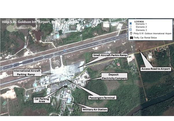
Philip S.W. Goldson International Airport (PGIA) is an airport that serves the Belize's largest city, Belize City, along the eastern coast of Central America. The airport was originally constructed in 1943 and was privatized in 2004.
Today PGIA has a runway of 2,950 m and 68,350 m2 of parking area. There is a full Crash Fire and Rescue Department and the airport is designated as a Category 8 in accordance with ICAO Annex 14. The management and operation is under the Belize Airport Concession Company, a consortium of Belizean investors that took over the administration and management in April 2004.
PGIA is at an elevation of 5 m (16 ft.) above the sea level. Due to its low elevation and coastal location both the airport and the entirety of Belize City are at risk of serious flooding. For this reason, Belize's capital has been moved to Belmopan while Philip S. W. Goldson International Airport remains the largest and busiest in the country.
The best way to get to and from the city center is via taxi. Although an airport bus service is in place, it is very infrequent and unreliable.
|
Airport Location and Contact |
|
|---|---|
|
Country |
Belize |
|
Province or District |
Ladyville |
|
Nearest Town or City |
Belize City (16 km) |
|
Airport’s Complete Name |
Phillip S.W. Goldson International Airport |
|
Latitude |
17.5391666667 |
|
Longitude |
-88.3080555556 |
|
Elevation (ft. and m) |
16 ft. / 5 m |
|
IATA Code |
BZE |
|
ICAO Code |
MZBZ |
|
Managing Company or Airport Authority |
Belize Airport Concession Company |
|
Management Contact Person |
Enrique Hoare – Manager of Operations |
|
Open From (hours) |
06:00 |
|
Open To (hours) |
18:00 |
Airport Picture
Description and Contacts of Key Companies
For more information on airport contacts, please see the following link: 4.5 Belize Airport Companies Contact List.
Information on some aviation service providers can be found at: http://www.azfreight.com/
Passenger and Cargo Performance Indicator
The airport terminal building has a total surface of 10,220 m2 (110,000 ft.2). It contains two terminals, international arrival and departure halls, a domestic arrival hall, restaurants, snack outlets, duty free and duty paid shops, a bank, and various other services.
There is a 1,115 m2 (12,000 ft.2) air cargo terminal building located on the northern section of the airport and accessible from the old airport road. There are eight cargo operators: Amerijet, Aero Dispatch, FedEx, DHL, E-Zone, AeroPost, Belize Post Office, and Sidasheari.
The PGIA is designated as a Category 8 Airport in accordance with ICAO Annex 14.
|
Performance for 2016 |
|||
|---|---|---|---|
|
Per Year |
Per Month |
Per Day |
|
|
Total Aircraft Movements |
30,414 |
2,535 |
85 |
|
Total Passengers |
867,796 |
72,330 |
2,400 |
|
Total Capacity of the Airport (MT) |
|||
|
Current Activity of the Airport (MT) |
|||
|
Current use by Humanitarian Flights (UNHAS) |
|||
Runways
Philip Goldson International Airport has only one airstrip with an extension of 2,950 x 46 m, which is in a good condition. There is a taxiway going from the west side of the airport to the head of the runway.
|
Runway #1 |
|
|---|---|
|
Runway Dimensions |
2950 x 46 m (9678 x 150 ft.) |
|
Orientation |
07/25 |
|
Surface |
Hard Asphalt - PCN 061FCWU |
Helicopter Pad(s)
Philip Goldson Airport does not have heliports or helipads. Helicopters need to use the same parking ramp as other aircrafts.
Airport Infrastructure Details
According to a concession agreement with the Belizean government, the concessionaire of the airport PGIA pursues an investment program that includes the modernization of the airport and its services. Investments to improve all airport services are foreseen to be finalized until 2020.
PGIA is also looking for funding to modernize the central building and to have access sleeves for passengers in addition to all boarding and disembarkation gates for passengers.
|
Customs |
Yes |
JET A-1 fuel |
Yes |
|---|---|---|---|
|
Immigration |
Yes |
AVGAS 100 |
Yes |
|
Terminal Building |
Yes |
Single Point Refueling |
Yes |
|
Passenger Terminal |
Yes |
Air Starter Units |
Yes |
|
Cargo terminal |
Yes |
Ground Power (mobile) |
Yes |
|
Pax Transport to Airfield |
No |
Ground Handling Services |
Yes |
|
Control Tower |
Yes |
Latrine Servicing |
Yes |
|
Weather Facilities |
Yes |
Fire Fighting Category (ICAO) |
Yes |
|
Catering Services |
Yes |
De-icing Equipment |
No |
|
Base Operating Room |
Yes |
Parking Ramp Lighting |
Yes |
|
Airport Radar |
Yes |
Approach & Runway Lights |
Yes |
|
NDB |
Yes |
VOR |
Yes |
|
ILS |
No |
LCN |
69 |
Airport Operating Details
The PGIA is equipped with three taxiways: Alpha, Bravo and Charlie. All three are 23 m (75 ft.) wide. Alpha is 750 m (2,470 ft.) long with 7.5 m (25 ft.) wide non-load bearing shoulders, while Bravo and Charlie are 150 m (484 ft.) long with no shoulders.
The parking apron at the PGIA is 514,220 m2 (615,800 ft.2) with a declared strength of 86 LCN. There are seven parking slots available for nose parking.
The following visual markings are available: visual markings on the runway, thresholds and designation markings, center lines, runway edge larkings and fixed distance markings.
The following lighting systems are in place: runway edge lights, threshold lights, taxiway edge lights, PAPI lights (left hand side of the runway) and stop way lights.
The following navigational aid is available: DVOR (Doppler VHF Omni-Directional Radar), DME (Distance Measuring Equipment), DRDF (Digital Readout Directional Finder and NDB (Non-directions beam).
|
Operating Details |
||
|---|---|---|
|
Maximum Sized Aircraft that can be Offloaded on Bulk Cargo |
L-10-20 or C-130 |
|
|
Maximum Sized Aircraft that can be Offloaded on Pallet |
Airbus A300 & A310 |
|
|
Total Aircraft Parking Area (m²) |
68,358 |
|
|
Storage Area (m2) |
1,115 |
|
|
Handling Equipment |
||
|
Elevators / Hi Loaders |
Yes |
Max Capacity (MT) |
|
Max Height (m) |
||
|
Loading Ramps |
Yes |
|
Customs Guidance
To clear the cargo all procedures have to be completed according to the customs regulations of Belize. The working hours of the customs offices are from Monday to Friday from 8:00 to 16:00
For more information on customs in Belize, please see the following link: 1.3 Belize Customs Information.
Storage Facilities
PGIA has roofed storage facilities for both import and export air cargo of 1,115 m2.
Fuel Service Charges
Puma Energy is the only operator of fuel supply for aircrafts.
|
|
Price per Litre USD - $ |
|---|---|
|
Jet A-1 |
2.90 |
|
Avgas |
5.20 |
Security
A project to strengthen airport security funded by the Inter-American Development Bank is currently ongoing. It consists of the following components: Regulatory strengthening of the DCA to meet new ICAO standards, provision of equipment for the Philip S.W. Goldson International Airport in support of the regulatory reform and training components, and training for specialized areas of airport security and the training of trainers.
In addition, the PGIA receives technical support to improve and update the security system.
2.2.3 Belize Hector Silva Airstrip
Airport Overview
Hector Silva Airstrip is in Belmopan, Belize. It was expanded by the British Army in 2002, in order to accept larger planes such as the Lockheed C-130 Hercules. The airstrip has a small terminal. The runways are not marked. Belize Defence Forces uses the airstrip for temporary landing facilities for their aircrafts.
|
Airport Location and Contact |
|
|---|---|
|
Country |
Belize |
|
Province or District |
Cayo District |
|
Nearest Town or City |
Belmopan City |
|
Airport’s Complete Name |
Hector Silva Airstrip |
|
Latitude |
17.26944444 |
|
Longitude |
-88.776111110 |
|
Elevation (ft and m) |
185 ft. / 56 m |
|
IATA Code |
BCV |
Runway
|
Runway #1 |
|
|---|---|
|
Runway Dimensions |
1067 x 18 m (3500 x 60 ft.) |
|
Runway Orientation |
11/29 |
|
Runway Surface |
Chip Seal Asphalt |
2.2.4 Belize Matthew Spain Airport
Airport Overview
|
Airport Location and Contact |
|
|---|---|
|
Country |
Belize |
|
Province or District |
Cayo District |
|
Nearest Town or City |
Central Farm |
|
Airport’s Complete Name |
Matthew Spain Airport |
|
Latitude |
17.18588889 |
|
Longitude |
-89.00972222 |
|
Elevation (ft and m) |
180 ft. / 55 m |
|
IATA Code |
SQS |
Runway
|
Runway #1 |
|
|---|---|
|
Runway Dimensions |
695 x 10 m (2280 x 35 ft.) |
|
Runway Orientation |
08/26 |
|
Runway Surface |
Chip Seal Asphalt |
2.2.5 Belize Caye Caulker Airport
Airport Overview
|
Airport Location and Contact |
|
|---|---|
|
Country |
Belize |
|
Province or District |
Belize District |
|
Nearest Town or City |
Caye Caulker Village |
|
Airport’s Complete Name |
Caye Caulker Airport |
|
Latitude |
17.73500000 |
|
Longitude |
-88.02944444 |
|
Elevation (ft and m) |
5 ft. \ 1.5 m |
|
IATA Code |
CUK |
Runway
|
Runway #1 |
|
|---|---|
|
Runway Dimensions |
860 x 12 m (2825 x 40 ft.) |
|
Runway Orientation |
09/27 |
|
Runway Surface |
Chip Seal Asphalt |
2.2.6 Belize Punta Gorda Airport
Airport Overview
Punta Gorda Airport is an airport serving Punta Gorda, a town located in Toledo District in Southern Belize.
|
Airport Location and Contact |
|
|---|---|
|
Country |
Belize |
|
Province or District |
Toledo District |
|
Nearest Town or City |
Punta Gorda Town |
|
Airport’s Complete Name |
Punta Gorda Airport |
|
Latitude |
16.10222222 |
|
Longitude |
-88.80805556 |
|
Elevation (ft and m) |
60 ft. / 18 m |
|
IATA Code |
PND |
Runway
|
Runway #1 |
|
|---|---|
|
Runway Dimensions |
747 x 7.6 m (2450 x 25 ft.) |
|
Runway Orientation |
06/24 |
|
Runway Surface |
Chip Seal Asphalt |
2.2.7 Belize Orange Walk Airport
Airport Overview
Orange Walk Airport or Alfredo Martinez Chan Pine Ridge Airstrip is a public airport located southwest of Orange Walk Town, Orange Walk District, Belize. The airstrip was refurbished with asphalt in 2014.
|
Airport Location and Contact |
|
|---|---|
|
Country |
Belize |
|
Province or District |
Orange Walk District |
|
Nearest Town or City |
Orange Walk Town (1.9 km) |
|
Airport’s Complete Name |
Orange Walk Airport |
|
Latitude |
18.04611111 |
|
Longitude |
-88.58361111 |
|
Elevation (ft and m) |
68 ft. / 21 m |
|
IATA Code |
ORZ |
Runway
|
Runway #1 |
|
|---|---|
|
Runway Dimensions |
700 x 18 m (2300 x 60 ft.) |
|
Runway Orientation |
10/28 |
|
Runway Surface |
Hot Mix Asphalt |
2.2.8 Belize Sartaneja Airstrip
Airport Overview
|
Airport Location and Contact |
|
|---|---|
|
Country |
Belize |
|
Province or District |
Corozal District |
|
Nearest Town or City |
Sartaneja Village |
|
Airport’s Complete Name |
Sartaneja Airstrip |
|
Latitude |
18.35555556 |
|
Longitude |
-88.13083333 |
|
Elevation (ft and m) |
55 ft. / 17 m |
|
IATA Code |
SJX |
Runway
|
Runway #1 |
|
|---|---|
|
Runway Dimensions |
762 x 11 m (2500 x 36 ft.) |
|
Runway Orientation |
10/28 |
|
Runway Surface |
Chip Seal Asphalt |
2.2.9 Belize Privacion Airstrip
Airport Overview
|
Airport Location and Contact |
|
|---|---|
|
Country |
Belize |
|
Province or District |
Cayo District |
|
Nearest Town or City |
Mountain Pine Ridge |
|
Airport’s Complete Name |
Privacion Airstrip |
|
Latitude |
17.03750000 |
|
Longitude |
-88.95861111 |
|
Elevation (ft and m) |
1500 ft. / 457 m |
|
IATA Code |
PRV |
Runway
|
Runway #1 |
|
|---|---|
|
Runway Dimensions |
1067 x 18 m (3500 x 60 ft.) |
|
Runway Orientation |
06/24 |
|
Runway Surface |
Compacted Sand |
2.2.10 Belize John Greif III Airport
Airport Overview
John Greif II Airport is an airport that serves San Pedro and Ambergris Caye, Belize. The airport has maintenance and terminal facilities as well as a paved and marked runway. The airport was renamed from San Pedro Airport to John Greif II Airport in 2010.
|
Airport Location and Contact |
|
|---|---|
|
Country |
Belize |
|
Province or District |
Ambergris Caye |
|
Nearest Town or City |
San Pedro Town |
|
Airport’s Complete Name |
John Greif III Airport |
|
Latitude |
17.91388889 |
|
Longitude |
-87.97111111 |
|
Elevation (ft and m) |
4 ft. / 1.2 |
|
IATA Code |
SPR |
Runway
|
Runway #1 |
|
|---|---|
|
Runway Dimensions |
1067 x 18 m (3500 x 60 ft.) |
|
Runway Orientation |
06/24 |
|
Runway Surface |
Hot Mix Asphalt |
2.2.11 Belize Dangriga Airport
Airport Overview
Dangriga Airport is a public airport located north of Dangriga, Stann Creek District, Belize.
|
Airport Location and Contact |
|
|---|---|
|
Country |
Belize |
|
Province or District |
Stann Creek District |
|
Nearest Town or City |
Dangriga Town (1 km) |
|
Airport’s Complete Name |
Dangriga Airport |
|
Latitude |
16.98250000 |
|
Longitude |
-88.23111111 |
|
Elevation (ft and m) |
10ft. / 3 m |
|
IATA Code |
DGA |
Runway
|
Runway #1 |
|
|---|---|
|
Runway Dimensions |
863 x 9 m (2830 x 30 ft.) |
|
Runway Orientation |
09/27 |
|
Runway Surface |
Hot Mix Asphalt |
2.2.12 Belize Melinda Airport
Airport Overview
Melinda Airport is a public airport located 9 km northwest of Melinda, Stann Creek District, Belize.
|
Airport Location and Contact |
|
|---|---|
|
Country |
Belize |
|
Province or District |
Stann Creek District |
|
Nearest Town or City |
Melinda (9 km) |
|
Airport’s Complete Name |
Melinda Airport |
|
Latitude |
17.00444444 |
|
Longitude |
-88.30416667 |
|
Elevation (ft and m) |
60 ft. / 18 m |
|
IATA Code |
MDB |
Runway
|
Runway #1 |
|
|---|---|
|
Runway Dimensions |
634 x 8 m (2080 x 25 ft.) |
|
Runway Orientation |
09/27 |
|
Runway Surface |
Chip Seal Asphalt |
2.2.13 Belize Placencia Airport
Airport Overview
Placencia Airport is an airport that serves Placencia, Belize. It has a paved strip and crosses the peninsula from East to West.
Due to the typical sea breeze, takeoffs and landings are typically done east-bound. Private flights are allowed. Parking should be coordinated with Tropic Air or Maya Island Air.
Common traffic advisory frequency (CTAF) is 122.8 MHz.
|
Airport Location and Contact |
|
|---|---|
|
Country |
Belize |
|
Province or District |
Stann Creek District |
|
Nearest Town or City |
Placencia Village |
|
Airport’s Complete Name |
Placencia Airport |
|
Latitude |
16.53722222 |
|
Longitude |
-88.36111111 |
|
Elevation (ft and m) |
25 ft. / 7.5 m |
|
IATA Code |
PLJ |
Runway
|
Runway #1 |
|
|---|---|
|
Runway Dimensions |
650 x 7.5 (2135 x 25 ft.) |
|
Runway Orientation |
07/25 |
|
Runway Surface |
Chip Seal Asphalt |
2.2.14 Belize Corozal Airport
Airport Overview
Corozal Airport is an airport that serves Corozal, Belize. It is located at the south entrance of Corozal, in Ranchito Village, and is therefore also known as Ranchito Airport.
|
Airport Location and Contact |
|
|---|---|
|
Country |
Belize |
|
Province or District |
Corozal District |
|
Nearest Town or City |
Ranchito Village |
|
Airport’s Complete Name |
Corozal Airport |
|
Latitude |
18.38166667 |
|
Longitude |
-88.41166667 |
|
Elevation (ft and m) |
12 ft. / 3.5 m |
|
IATA Code |
CZH |
Runway
|
Runway #1 |
|
|---|---|
|
Runway Dimensions |
670 x 9m (2200 x 30 ft.) |
|
Runway Orientation |
07/25 |
|
Runway Surface |
Hot Mix Asphalt |
2.3 Belize Road Network

The road network in Belize consists of 3,281 km of which approximately 601 km are paved and 2680 km are unpaved.
The following roads constitute the four main road networks. They consist of asphalt-paved two-lane roads. Due to continuous maintenance they are in good condition for transportation:
- Philip Goldson Highway (formerly Northern Highway), between Belize City and the Mexican border north of Corozal, about 95 miles or 153 km (Referred in the map as “N”)
- George Price Highway (formerly Western Highway), between Belize City and the Guatemalan border near Benque Viejo del Carmen, about 81 miles or 130 km(Referred in the map as “W”)
- Hummingbird Highway, from Belmopan to Dangriga, about 55 mile or 89 km (Referred in the map as “H”)
- Southern Highway, from Dangriga to Punta Gorda (Referred in the map as “S”), 157.3 km
Most maps also include the Old Northern Highway, which provides access to the Altun Ha ruins. This single-lane road is partly paved, but deteriorates dramatically just north of the access road to the ruins.
The Coastal Highway, also known as the Manatee Highway or the Shortcut, connects the Western Highway (48 km west of Belize City) with the Stann Creek Valley near Dangriga. This highway is all gravel and may wash out during heavy rains.
The Ministry of Public Works is responsible for planning, construction and maintenance of the country’s roads and bridges, as well as some roads, drains and waterways in cities. There are serious shortfalls in the resources to meet the repair demand of the highways, with nearly all streets having areas of disrepair. Road infrastructure is financed by the national government, as well as by grants and loans from bilateral and multilateral sources, all implemented by the Ministry of Public Works.
For more information on government contact details, please see the following link:
4.1 Belize Government Contact List.
Distance Matrix
|
Distances from Capital City to Major Towns (km) |
||||||||
|---|---|---|---|---|---|---|---|---|
|
Belmopan |
Belize City |
San Ignacio |
Benque Viejo |
Corozal |
Santa Elena |
Dangriga |
Punta Gorda |
|
|
Belmopan |
88 |
118 |
130 |
228 |
238 |
89 |
246 |
|
|
Belize City |
88 |
118 |
218 |
153 |
163 |
177 |
334 |
|
|
San Ignacio |
118 |
206 |
12 |
359 |
369 |
207 |
364 |
|
|
Benque Viejo |
130 |
218 |
12 |
358 |
368 |
219 |
376 |
|
|
Corozal |
228 |
153 |
359 |
371 |
10 |
317 |
474 |
|
|
Santa Elena |
238 |
163 |
356 |
368 |
10 |
327 |
484 |
|
|
Dangriga |
89 |
177 |
207 |
219 |
317 |
327 |
335 |
|
|
Punta Gorda |
246 |
334 |
364 |
376 |
474 |
484 |
335 |
|
|
Travel Time from Capital City to Major Towns (hours’ minutes”) |
||||||||
|---|---|---|---|---|---|---|---|---|
|
Belmopan |
Belize City |
San Ignacio |
Benque Viejo |
Corozal |
Santa Elena |
Dangriga |
Punta Gorda |
|
|
Belmopan |
1’25” |
1’55” |
2’10” |
3’25” |
3’35” |
1’25” |
3’50” |
|
|
Belize City |
1’25” |
2’55” |
2’10” |
2’18” |
2’32” |
2’52” |
4’35” |
|
|
San Ignacio |
1’55” |
2’55” |
17” |
5’12” |
5’08” |
2’55” |
5”20” |
|
|
Benque Viejo |
2’10” |
3’02” |
17” |
5’30” |
5’25” |
“3’12” |
5’37” |
|
|
Corozal |
3’25” |
2’18” |
5’12” |
5’30” |
14” |
4’32” |
6’55” |
|
|
Santa Elena |
3’35” |
2’32” |
5,08” |
5’25” |
14” |
4’32” |
7’15” |
|
|
Dangriga |
1’25” |
2’52” |
2’55” |
3’12 |
4’32” |
4’42” |
4’51” |
|
|
Punta Gorda |
3’50” |
4’35” |
‘5’20” |
5’37” |
6’55” |
7’15” |
4”51” |
|
Road Security
There is very little control on the roads by the police or the state authorities. Traffic signals and speed limits are not much respected. While in villages and along roads, presence of public authorities is weak, the frequency of controls increases close to large cities. Frequent accidents include frontal accidents on the highway between Belize City and Belmopan.
On overland transports, weight indication for trucks is not specified. Equally, bridges are not marked with the maximum weight or the number of axes allowed and technical Management is not available.
2.3.1 Belize Benque Viejo Border Crossing
Overview
The Border Management Agency is the responsible administrative entity for the management of Belize’s border complex, including immigration, police, customs, the Pan American Health Organisation (PAHO) and Free Zone areas. Major border movement to Guatemala is related to crossing of pedestrians. The Free Zone area is active but less frequented than at the northern entrance points to Mexico. Administration of the Free Zone is under shared responsibility of a Belizean private group and governmental agencies.
|
Border Crossing Location and Contact |
|
|---|---|
|
Name of Border Crossing |
Belize: Benque Viejo del Carmen |
|
Province or District |
Cayo District |
|
Nearest Town or City with Distance from Border Crossing |
Benque Viejo del Carmen (1 km) |
|
Latitude |
17.05777778 |
|
Longitude |
-89.15500000 |
|
Managing Authority / Agency |
Border Management Agency |
|
Contact Person |
Mr Rolando Leon |
|
Travel Times |
|
|---|---|
|
Nearest National Airfield |
Maya Flats (3 km) Truck Travel Time: 10 minutes Car Travel time: 10 minutes |
|
Nearest Port |
Belize City (112 km) Truck Travel Time: 3 hours Car Travel time: 3 hours |
|
Nearest location with functioning wholesale markets, or with significant manufacturing or production capacity |
Spanish Lockout (30 km) Truck Travel Time: 30 minutes Car Travel time: 30 minutes |
|
Other Information
|
Road from Belmopan (main city of Belize) is in good condition, with fuel stations in Benque Viejo. The free zone area to Guatemala is very active in terms of commerce. Storage capacity of approx. 923 m2 (10,000 ft.2) is available in the Free Zone area for exports to Guatemala. |
|
Hours of Operation |
|
|---|---|
|
Mondays |
24 hours |
|
Tuesdays |
24 hours |
|
Wednesdays |
24 hours |
|
Thursdays |
24 hours |
|
Fridays |
24 hours |
|
Saturdays |
24 hours |
|
Sundays |
24 hours |
The opening hours of customs offices are from Monday to Friday 8:00 to 17:00.
Daily Capacity
Customs capacities to deal with cars is limited and becomes critical from 30 cars/hour due to the small border crossing. Trucks are not affected since they use different routes. The entrance to free zones involves different procedures which makes it is less vulnerable to traffic issues.
Customs Clearance
Trucks are charged with a parking fee per day. The price is relative to the size of the vehicle and starts from USD$ 30, which is the only additional charge raised by the border authority. Import duties are relative to the value of the goods imported. All importation paperwork can be done and clearance can be obtained within one day at the customs offices at the border. All vehicles are inspected before getting customs clearance.
For more information on customs in Belize, please see the following link: 1.3 Belize Customs Information.
For more information on government contact details, please see the following link: 4.1 Belize Government Contact List.
2.3.2 Belize Santa Elena Border Crossing
Overview
The Border Management Agency is the responsible administrative entity for the management of Belize’s border complex, including immigration, police, customs, the Pan American Health Organisation (PAHO) and free zone areas. Mayor border movement to Mexico is related to crossing of pedestrians. The Free Zone is active and more frequented than the one located at the western entrance point to Guatemala. Administration of the Free Zone is under shared responsibility of a Belizean private group and governmental agencies.
|
Border Crossing Location and Contact |
|
|---|---|
|
Name of Border Crossing |
Belize: Santa Elena |
|
Province or District |
Corozal District |
|
Nearest Town or City with Distance from Border Crossing |
Corozal (10 km) |
|
Latitude |
18.48555556 |
|
Longitude |
-88.39916667 |
|
Managing Authority / Agency |
Border Management Agency |
|
Contact Person |
Misses Naivi Campos |
|
Travel Times |
|
|---|---|
|
Nearest National Airfield |
Aeropuerto Corozal (Ranchito) (13 km) Truck Travel Time: 18 minutes Car Travel time: 18 minutes |
|
Nearest Port |
Belize City (120 km) Truck Travel Time: 3 ¼ hours Car Travel time: 3 ¼ hours |
|
Nearest location with functioning wholesale markets, or with significant manufacturing or production capacity |
Orange Walk (50 km) Truck Travel Time: 1hour Car Travel time: 1 hour |
|
Other Information
|
Road in good condition from Belmopan (main city of Belize), with fuel stations in Corozal and Santa Elena. The Free Zone area to Mexico is very active in terms of commerce. Storage capacity of approx. 2,322 m2 (25,000 ft.2) in the Free Zone area is available for exports to Mexico. |
|
Hours of Operation |
|
|---|---|
|
Mondays |
24 hours |
|
Tuesdays |
24 hours |
|
Wednesdays |
24 hours |
|
Thursdays |
24 hours |
|
Fridays |
24 hours |
|
Saturdays |
24 hours |
|
Sundays |
24 hours |
Opening hours of customs offices are from Monday to Friday 8:00 to 17:00.
Daily Capacity
Due to the existing free zone, there is a lot a traffic during the weekends from people coming more from the Mexican side. Most of these people stay during the weekend. Belizeans are excluded from the free zone but have a separate entrance where they do not affect the normal transit to customs facilities and border offices.
Customs Clearance
Trucks are charged with a parking fee per day. The price is relative to the size of the vehicle and starts from USD 30, which is the only additional charge made by the border authority. Importation duties are relative to the value of the goods imported. All importation paperwork can be done and clearance can be obtained within one day at the customs offices at the border. All vehicles are inspected before getting customs clearance.
For more information on customs in Belize, please see the following link: 1.3 Belize Customs Information.
For more information on government contact details, please see the following link: 4.1 Belize Government Contact List.
2.4 Belize Railway Assessment
There is no railway network available in Belize.
2.5 Belize Waterways Assessment

The rivers of Belize are not used for cargo or passenger transportation.
In coastal areas, maritime transport is available as both international maritime transportation for bulk and container shipping and local maritime transportation provided by fishing vessels, freight barges and recreational boats. Several water taxi operators run formal and informal services, largely linked to tourism, to the islands and offshore destinations. Some operators have boats with a capacity of more than 100 passengers.

For more information on government contact details, please see the following link:
4.1 Belize Government Contact List.
Company Information
Companies offering services of water taxi include the following:
- Caye Caulker Water Taxi Association
- San Pedro Belize Express Water Taxi
- Ocean Ferry Belize
- Tropic Ferry
- Nautilus Express Water Taxi
- Thunderbolt Water Taxi
- Coastal Express
|
Passenger Carrying Capacity |
|||
|---|---|---|---|
|
Caye Caulker |
San Pedro |
Ocean Ferry |
|
|
Number of Passenger Vessels < 50 Passengers |
2 |
1 |
3 |
|
Number of Passenger Vessels > 100 Passengers |
2 |
3 |
2 |
|
Passenger Carrying Capacity |
|||
|---|---|---|---|
|
Caye Caulker |
San Pedro |
Ocean Ferry |
|
|
Boats |
|||
|
Number of Boats |
4 |
4 |
5 |
|
Tonnage / Volume Carrying Capacity (MT / m3) |
Up to 100 pax |
Up to 114 pax |
Up to 140 pax |
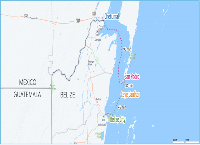
Travel Time Matrix
Schedules that indicate arrival and departure times from water taxi operators are largely respected. Water taxis are mainly used for commuting and transporting cargo (41%), touristic visits to the islands (30%) and general transportation (29%). Most of the water taxi operators have their own port facilities in Belize City and North Front Street.
|
Travel Time from Belize City to other major Destinations on Water Taxi Boat |
||||
|---|---|---|---|---|
|
Belize City |
Caye Caulker |
San Pedro |
Chetumal |
|
|
Belize City |
45 minutes |
90 minutes |
180 minutes |
|
|
Caye Caulker |
45 minutes |
45 minutes |
135 minutes |
|
|
San Pedro |
90 minutes |
45 minutes |
90 minutes |
|
|
Chetumal |
180 minutes |
135 minutes |
90 minutes |
|
Key Routes
|
Key Route Information Domestic / International |
|||
|---|---|---|---|
|
From: Belize City To: San Pedro |
From: Belize City To: Caye Caulker |
From: Belize City To: Chetumal |
|
|
Total Distance (km) |
90 km |
45 km |
130 km |
|
Width (m) |
Broadest: 25 m |
Broadest: 25 m |
Broadest: 25 m |
|
Seasonal Effects |
No |
No |
No |
|
Regular Traffic Passenger / Cargo |
Yes |
Yes |
Yes |
|
Companies Operating Along the Route |
Several |
Several |
Several |
|
Security Concerns |
No |
No |
No |
|
Main Ports |
No |
No |
No |
Port Information
|
Key Port Information |
|||
|---|---|---|---|
|
Belize City |
San Pedro |
Caye Caulker |
|
|
Location |
Belize City |
San Pedro |
Caye Caulker |
|
Contact Information |
Each Operator |
Each Operator |
Each Operator |
|
Connections with Other Transport Means |
Road and by air |
Only by air |
Only by air |
|
Storage Capacity (m2 and m3) |
10 m2 |
15 m2 |
10 m2 |
|
Handling Equipment |
No |
No |
No |
|
Customs Clearance Available |
No |
No |
No |
|
Other Comments |
Small port facilities for passengers |
Small port facilities for passengers |
Small port facilities for passengers |
Disclaimer: Inclusion of company information in the LCA does not imply any business relationship between the supplier and WFP / Logistics Cluster, and is used solely as a determinant of services, and capacities.
Please note: WFP / Logistics Cluster maintain complete impartiality and are not in a position to endorse, comment on any company's suitability as a reputable service provider.
2.6 Belize Storage Assessment
Storage facilities are located along the two landborders (Mexico and Guatemala) and at the two seaports, Belize City and Big Greek Port. Additionally, five warehouses of the National Emergency Management Organization (NEMO) are located throughout the country in strategic points and in high areas to avoid flooding.
The storage capacity of the border with Guatemala (Benque Viejo Border) is 930 m2 (10,000 ft.2). In case of a natural disaster, all of these warehouses can be made available to support the emergency response in coordination with NEMO.
For the northern border with Mexico, the Border Management Agency has a storage capacity of 9,290 m2 (100,000 ft.2). In case of a natural disaster the border can be used as an entry point for humanitarian assistance to Belize through road transportation.
For more information on storage company contact details, please see the following link: 4.6 Belize Storage and Milling Companies Contact List
Commercial Storage
The majority of warehouses available are for private use and not for rent. In case of emergency, NEMO is in charge of establishing warehouses.
Storage Used by Humanitarian Organizations
NEMO has five storage facilities in good condition installed in Belize, from which emergencies have been managed during the last six years. The warehouses are located far from the coast to avoid damage by floods.
|
Location |
Organization |
Sharing Possibility |
Capacity (Sq. ft.) |
Type [1] |
Access [2] |
Condition [3] |
|---|---|---|---|---|---|---|
|
Belize City |
NEMO |
Yes |
2,000 |
Concrete |
Good Raised-Siding |
Appears Intact |
[1] Warehouse Type: Open storage, container, rub-hall, silo, and concrete, other, unspecified
[2] Warehouse Access: Raised-siding, flat
[3] Warehouse condition: Appears intact, appears damaged, under construction/repair
Public Sector Storage
No warehouses or deposits of any state entity could be identified.
Cold Chain
The cold chain for ocean shipments is ensured through refrigerated containers at both ports.
|
Location |
Organization / Owner |
Type [1] |
Cooling / Power [2] |
Quantity |
Total Capacity (m³) |
Condition |
|---|---|---|---|---|---|---|
|
Big Creek Port |
Big Creek Group |
Freezer Container |
Compression |
120 |
7,884 |
Good |
|
Port of Belize |
Port of Belize Limited |
Freezer Container |
Compression |
72 |
4,248 |
Good |
[1] Cold Room Positive, Cold Room Negative, Refrigerator,
Freezer,
[2] Compression, Absorption, Solar, Other, unspecified
2.7 Belize Milling Assessment
For more information on milling company contact details, please see the following link: 4.6 Belize Storage and Milling Companies Contact List
Milling Company Belize Sugar Industries Ltd. (BSI)
Belize Sugar Industries Ltd. (BSI) was founded in 1963 and has been producing sugar in the northern town of Orange Walk since 1967. BSI grinds 1.3 million mt of sugarcane each year with an average daily milling throughput of 6,800 mt.
|
Company Name and Address |
Telephone and Fax |
|---|---|
|
Belize Sugar Industries Ltd. (BSI) Tower Hill Street Orange Walk Town Belize |
Tel: (501) 322-2150
|
Disclaimer: Inclusion of company information in the LCA does not imply any business relationship between the supplier and WFP / Logistics Cluster, and is used solely as a determinant of services, and capacities.
Please note: WFP / Logistics Cluster maintain complete impartiality and are not in a position to endorse, comment on any company's suitability as a reputable service provider.