2 Egypt Logistics Infrastructure

The transportation sector is one of the main drivers of economic development and growth in Egypt, linking production and consumption markets. Egypt’s unique geographic location combined with an expanding infrastructure base is enhancing the country’s position as a key global logistics hub. Egypt is currently embarking on a host of transportation projects in metros and tunnels, railways, ports, and roads.
Roads
Roads play a key role in Egypt transport network, with 94% of Egypt’s freight using roads. Egypt has climbed from the 118th in 2014 in the global road’s quality ranking to 75th in 2018.
Egypt's government spent LE 22.5 billion to build 5,000 km of new roads and renovate and develop others. 2018 saw the new roads significantly reduce the traffic accidents in Egypt. In September 2018, the Egyptian President inaugurated road projects worth LE 7 billion; six over-the-Nile bridges have been completed and another ten are still under construction.
At a cost of LE 36 billion, Egypt will increase its roads in km from 24,000 to about 29,000. Most prominently, the government has focused on highways. It is expected that all road developments within this project will be complete by 2020; the roads established as a result of this project will constitute about 20% of all roads in Egypt.
The government plans a series of road upgrades, including:
- Egypt MOT - The National Roads Project - Phase 1 - Ahmad Hamdi Tunnel Link.
- Egypt MOT - The National Roads Project - Phase 1 - Assiut/Sohag/Red Sea Road.
- Egypt MOT - The National Roads Project - Phase 1 - Cairo to Suez Road Enhancement.
- Egypt MOT - The National Roads Project - Phase 1 - Eastern Circular Sector Road.
- Egypt MOT - The National Roads Project - Phase 1 - Eastern Ring Road.
- Egypt MOT - The National Roads Project - Phase 1 - Faiyum/Wahat Road.
- Egypt MOT - The National Roads Project - Phase 1 - Farafra/Ain Dallah Road.
- Egypt MOT - The National Roads Project - Phase 1 - Khashm El Raqba Road.
- Egypt MOT - The National Roads Project - Phase 1 - Minya/Ras Gharib Road.
- Egypt MOT - The National Roads Project - Phase 1 - Qena to Safaga Road.
- Egypt MOT - The National Roads Project - Phase 1 - Regional Ring Road.
- Egypt MOT - The National Roads Project - Phase 1 - Sheikh Fadl to Ras Gharib Road.
- Egypt MOT - The National Roads Project - Phase 1 - Shubra to Banha Road.
- Egypt MOT - The National Roads Project - Phase 1 - Shubra to Banha Road Expansion - Sector 2.
- Egypt MOT - The National Roads Project - Phase 1 - Sohag to Al Ghardaqa.
- Egypt MOT - The National Roads Project - Phase 1 - Wadi Al Natrun to Al Alamein Road
- Egypt MOT - The National Roads Project - Phase 3 - Cairo/Western Assiut Road.
- Egypt MOT - The National Roads Project - Phase 3 Suez to Ahmad Hamdi Tunnel Road.
- Egypt MOT - The National Roads Project - Phase 3 Wahat Road/6th October.
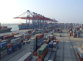
Ports
The government is reported to be planning to triple trade handled by ports in Egypt and has drafted a long-term plan to raise ports capacity from 120 million tonnes to 370 million tonnes by 2030.
The Red Sea Ports Authority (RSPA) manages nine ports in the Red Sea: Portawfik, Petroleum Basin Port, Adabeya, Sukhna, Hurghada, Safaga, El-Tur, Sharm El-Sheikh and Nweiba. The RSPA is responsible for constructing and periodically maintaining the marine quays of all nine ports, and for servicing the ships using these ports.
The RSPA announced plans to construct dry bulk, container and mixed-use terminals along the nine ports managed by the authority. RSPA has planned 15 projects with an average value of US$ 60 million; and eight projects with an average value of US$ 400 million.
The most notable projects will take place in Soukhna Port, which lies south of Suez and forms part of the Suez Canal Area Development Project (SCADP)
Constructing, operating and managing a Liquid Bulk Terminal
- Capacity: 15 million tonnes of oils per year
- Quay: 2,000 m long; 14 - 17 m deep
- Land area: 900,000 m2
- Estimated Capex: US$ 650 million
https://egyptoil-gas.com/news/liquid-bulk-terminal-to-receiver-500m-in-financing/
Constructing, operating and managing a Dry Bulk Terminal
- Capacity: 12 million tonnes per year
- Quay: 1700 m long; 17 m deep
- Land area: 720,000 m2
- Capex: US$ 500 million
Constructing, operating and managing an Agricultural Crops Terminal
- Capacity: 8 million tonnes per year
- Quay: 1,100 m long; 14 - 17 m deep
- Land area: 580,000 m2
- Capex: US$ 360 million
Constructing, operating and managing a Second Containers Terminal
- Capacity: 5 million equivalent containers per year
- Quay: 2,200 m long; 17 m deep
- Land area: 2,000,000 m2
- Capex: US$ 650 million
Constructing, operating and managing Dry Bulk Terminal No. 2
- Capacity: 8 million tonnes per year
- Quay: 1,100 m long; 17 m deep
- Land area: 510,000 m2
- Capex: US$ 287 million
Constructing, operating and managing a Third Container Terminal
- Capacity: 6 million equivalent containers per year
- Quay: 2,500 m long; 17 m deep
- Land area: 1,700,000 m2
- Capex: US$ 715 million
Constructing, Operating and Managing Multi-purpose Terminal (1)
- Capacity: 2 million tonnes per year
- Quay: 580 m long; 17 m deep
- Land area: 400,000 m2
- Capex: US$ 143 million
Constructing, Operating and Managing Multi-purpose Terminal (2)
- Capacity: 2 million tonnes per year
- Quay: 750 m long; 17 m deep
- Land area: 370,000 m2
- Capex: US$ 173 million
Railways
The co-chairman of the Egyptian National Railways (ENR) announced a US$ 10 billion investment over 10 years to upgrade and maintain the antiquated railways network; with US$ 2.2 billion coming from the World Bank. The investment will upgrade the rolling stock, rail Infrastructure, as well as training and knowledge transfer. Egypt has plans to expand and upgrade its rail network. There are plans to connect Luxor and Hurghada by a railway line, and to build light rail to connect Cairo with its two main satellite cities: 6th October in the west and New Cairo in the east. However, the most notable railway project is the High-Speed Rail (HSR) from Alexandria to Aswan. HSR is a new railway alignment dedicated for the high-speed train between Alexandria and Aswan through Cairo, Assiut and Luxor. The line is planned to be built in three phases:
Phase I: Cairo - Alexandria
A pre-feasibility study has been conducted by an Italian company, and indicated the following key parameters:
- Line length: 202 km
- The running speed: 300-350km/h
- Execution duration: 5 years
- Trip time: 60 minutes non-stop
- Expected passengers: from 10 to 18 million/year
- Capex estimate: US$ 3.5 billion
Phase II: Cairo - Luxor
The development of the tender document and TOR for the feasibility study is ongoing. The basic data of the line are:
- Line length: 680 km
- The running speed: 300-350 km/h
- Execution duration: 8 years
- Expected passengers: 25 to 30 million/year
Phase III: Luxor - Aswan
The development of the tender document and TOR for the feasibility study is ongoing. The basic data of the line are:
- Line length: 210 km
- The running speed: 300 -350km/h
- Expected passengers: 25 to 30 million/year
In 2018 with the successful implementation of the country’s largest project to improve railway efficiency and infrastructure came at a cost of LE 12.5 billion. The results of the project will be presented next year, along with the purchase of 1,300 coaches at a cost of LE21 billion alongside 100 locomotives. The ministry has already completed the largest and most difficult part of investment, which is investing in infrastructure such as with a new project to electrify train signals in accordance with international standards, allowing trains to go up to 140 km/hour.
2.1 Egypt Port Assessment
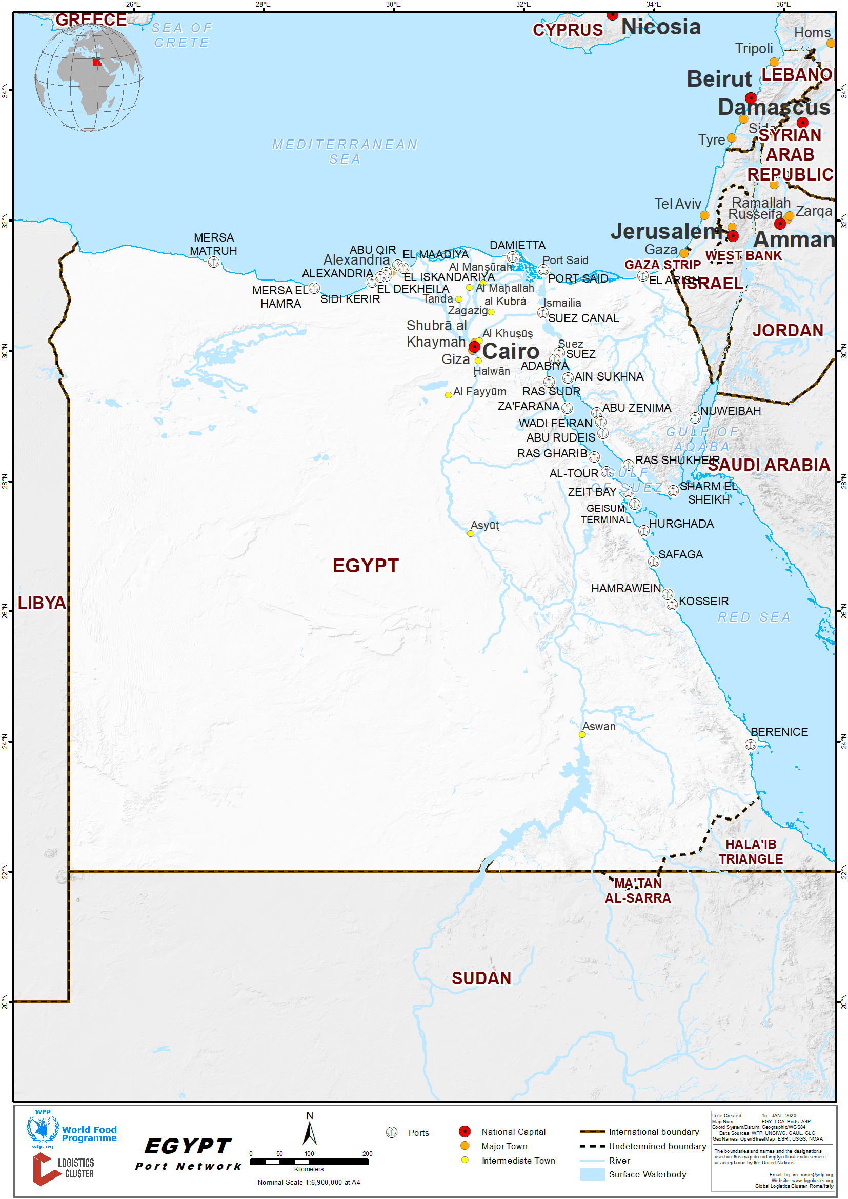
Egypt’s geographical location leads an important aspect to the maritime transport sector as it overlooks both the Mediterranean and Red Sea, linked by the Suez Canal. The Suez Canal remains a huge asset as it is the main trade route between Europe and Asia, accounting for roughly 7.5% of world sea trade. Any disruption on the narrow passage could cause major delays and cause a spike in transport costs. Most importantly, the Suez Canal is one of the world’s five ‘strategic chokepoints’, defined as narrow sea passages or straits, through which the overwhelming majority of the world’s oil flows.
Egypt has 40 sea ports, of which 12 are commercial ports; six mining ports; six fishing ports; five marinas; and 10 oil-shipping ports. Among the most important ports are Alexandria, the biggest port in Egypt, and the Port of Dekheila, which is a natural extension to the Port of Alexandria.
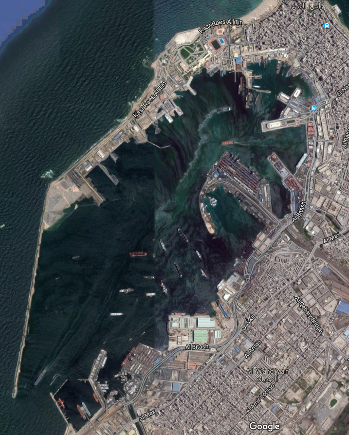
2.1.1 Egypt Port of Alexandria
Port Overview
Key port information can also be found at: Website of the Maritime Database on the Port of Alexandria
The Port of Alexandria contains two harbours separated by a peninsula. The East harbour is too shallow for navigation, and the West harbour is used for commercial shipping and trade. The Port of Alexandria has two navigation channels. Pilotage is required for all vessels entering or leaving the Port of Alexandria. The Port of Alexandria covers a total area of 10.2 km2, including 2 km2 of land and 8.5 km2 of water.
Port website: Alexandria sea port webpage
|
Port Location and Contact |
|
|
Country |
Egypt |
|
Province or District |
Alexandria |
|
Nearest Town or City with Distance from Port |
Name: Alexandria |
|
Port's Complete Name |
Alexandria Sea Port |
|
Latitude |
31° 11' 36.9492" North |
|
Longitude |
29° 52' 34.5252" East |
|
Managing Company or Port Authority |
General Authority for Alexandria Port |
|
Management Contact Person |
Admiral / TARIK SHAHIN |
|
Nearest Airport and Airlines with Frequent International Arrivals/Departures |
Airport Name: Borj El Arab Airlines: EgyptAIR |
Port Picture
Description and Contacts of Key Companies
For more information on port contacts, please see the following link: 4.4 Egypt Port and Waterways Companies Contact List
Port Performance
General analysis of port operating status during 2017.
Alexandria Terminal
The present throughput capacity for Alexandria container terminal Is 500,000 TEU, while the design capacity was 160,000 TEU.
The Alexandria Terminal has:
- Special Depot for Stripping L.C.L.
- Special Yard for Stuffing Exported Cargo In Containers.
|
Terminal Area |
163,000 m2 |
|
Storage Capacity |
15,500 TEU |
|
Container Quay Length |
531m |
|
Water Depth |
12m |
|
Ro / Ro Quay Length |
164m |
|
Ro / Ro Slide Width |
50m |
|
Reefer Connections |
1000 Connection |
El-Dekheilla Terminal
The present throughput capacity for EL-Dekheilla Terminal is 1 million TEU.
EL Dekheilla Terminal has a depot for storing cargo received in L.C.L. & Hazardous Cargo Containers.
|
Terminal Area |
406,000 m2 |
|
Storage Capacity |
27,000 TEU |
|
Container Quay Length |
1040m |
|
Water Depth |
12-14m |
|
Ro / Ro Quay Length |
Part of the Main Quay |
|
Ro / Ro Slide Width |
50m |
|
Reefer Connections |
1000 Connection |
Ships and cargo Status in Alexandria (2017 Annual Report)
Total number of ships was 4232, with the following details:
- General goods: 1220 ships
- Tankers: 641 ships
- Containerised: 1274 vessels
- Break Bulk: 661 ships
- Ferries: 240 ships
- Pax (tourism ): 8 ships
Total Quantity Handled Cargo: 56,648,662 ton, consisting of:
- Total Handled tonnage - 44,101,054 MT (78%)
- Total Quantity Exported Cargo - 12,547,608 MT (22%)
Total Handled Containerised cargo: 1,612,740 TEU STC 3,706,138 ton, split as follows:
- Total Imported Containers 826,994 TEU STC 2,285,355 tons (62% of total)
- Total Exported Containers 785,746 TEU STC 1,420,783 tons ( 38% of total )
Total non-containerised cargo: 42,124,770 MT, out of which:
- Imported cargo: 35,396,530 MT
- Exported cargos: 6,728,240 MT
Handled Food Commodities:
- Wheat: 1,857,901 (50% )
- Corn: 1,530,705 mt (42%)
- Soya bean: 293,946 (8%)
|
Seasonal Constraints |
||
|
|
Occurs |
Time Frame |
|
Rainy Season |
Yes |
From October to February |
|
Major Import Campaigns |
No |
N/a |
|
Other Comments |
N/a |
|
|
Handling Figures for 2017 |
|
|
Vessel Calls |
4232 |
|
Container Traffic (TEUs) |
1,612,740 |
|
Handling Figures Bulk and Break Bulk for 2017 |
|
|
Bulk (MT) |
|
|
Break bulk (MT) |
42,124,770 |
Berthing Specifications
|
Type of Berth |
Quantity |
Length (m) |
Maximum Draft (m) |
Comments |
|
Conventional Berth |
48 |
6532 |
12.81 |
|
|
Container Berth |
4 |
732 |
12.49 |
|
|
Silo Berth |
3 |
695 |
10.00 |
|
|
Berthing Tugs |
68 |
N/a |
N/a |
|
|
Water Barges |
NA |
N/a |
N/a |
|
See this
link for further narrative about
berths available on the Port of Alexandria website.
General Cargo Handling Berths
|
Cargo Type |
Berth Identification |
|
Imports - Bagged Cargo |
1/5-2/5-3/5-4/5-9-10- 11-12-13-14-25-26-27- 28-35-36-37-38-39-40- 41-42-43-44-82 |
|
Exports - Bagged Cargo |
Same as above |
|
Imports and Exports - RoRo |
25/26 M |
|
Other Imports |
3 |
Port Handling Equipment
Port equipment is managed by the government.
|
Equipment |
Available |
Total Quantity and Capacity Available |
Comments on Current Condition and Actual Usage |
|
Dockside Crane |
Yes |
9 Panamax 6 super post Panamax |
With twin spreader
|
|
Container Gantries |
Yes |
29 |
|
|
Mobile Cranes |
Yes |
27 |
|
|
Reach stacker |
Yes |
8 |
|
|
RoRo Tugmaster (with Trailer) |
Yes |
75 |
|
|
Grain Elevator with Bagging Machines |
Yes |
N/a |
|
|
Transtainer |
Yes |
16 |
|
|
Forklifts |
Yes |
15 |
|
Container Facilities
|
Facilities |
20 ft |
40 ft |
|
Container Facilities Available |
Yes |
Yes |
|
Container Freight Station (CFS) |
Yes |
Yes |
|
Refrigerated Container Stations |
Yes |
Yes |
|
Other Capacity Details |
||
|
Daily Take Off Capacity (Containers per Day) |
2200 TEU |
|
|
Number of Reefer Stations (Connection Points) |
2000 |
|
|
Emergency Take-off Capacity |
N/A |
N/A |
|
Off take Capacity of Gang Shift (Containers per Shift) |
N/A |
N/A |
Customs Guidance
The Customs Department is one of the interests of the Ministry of Finance and extends its role from the collection of fees and taxes to control the movement of goods imported to the country and goods imported from the country.
The core functions of the Customs can be determined as follows:
- The collection of fees and taxes and other receipts paid by importers and exporters according to the Customs Tariff Act and other relevant laws.
- Protect state revenues, and that by preventing the evasion of duties and ensure payment of fees and taxes due
- Control of warehouses in ports and marine air, and follow-up of raw materials exempted from customs duties
- Supervision on the movement of the stock of goods in the stores of public and private warehouses authorized to store imported goods
- Commitment to implement the decisions and rules and standards issued by the ministries and government departments other in the country such as the Ministry of Agriculture and the Ministry of Commerce and the Ministry of Culture and the Ministry of the Interior, and also the interest of the veterinary quarantine and quarantine, and the Drug Enforcement Administration and management of the inspection of weapons and explosive materials, Ministry of management and internal control over artistic works and publications.
- Of functions that are specific to the Customs Department is to combat smuggling, either to the inside or outside the country through customs, either sea or air, or land. Customs and focus its efforts in following up on all the ports that are expected to occur through smuggling activities taking place in order to avoid paying duties and taxes or to enter drug and prohibited materials into the country, or breach of customs legislation.
- And the customs with the help of other regulatory bodies
to tighten control over the incoming or
outgoing goods or prohibited.
Examples of such Bodies:
- Ministry of Communications and Information
- Department of Health
- Ministry of the Interior
- Department of State
- Department of Defense
- Drug Enforcement Administration
- Industrial Control Authority
- interest quarantine
- Department of censorship and Publication
- Environmental Protection Agency
- and other
- And Customs is working to enhance the performance of customs tariff in various sectors, and through the introduction of new techniques such as pre-release and also the application of risk management techniques widely in various areas of customs.
And all disclosures and inspection of the goods, whether imported or exported by the customs, those goods are dealt with according to special rules for testing adhered to by staff in the departments of customs examination.
For more information on customs in Egypt, please see the following link: 1.3 Egypt Customs Information
Terminal Information
MULTIPURPOSE TERMINAL
Approximately 27 terminals operative to handle the conventional cargo. They vary from 70m to 360m length and 5m to 11m draft.
GRAIN AND BULK HANDLING
There are nine terminals to handle the grain and flour. They vary from 60m to 210m length and 6m to 11m draft.
MAIN STORAGE TERMINAL
|
Storage Type |
Number of Storage Facilities |
Area (m2) |
|
Bagged Cargo |
N/a |
N/a |
|
Refrigerated Cargo |
N/a |
Approx. 3,760 m2 |
|
General Cargo |
N/a |
Approx. 86,136 m2 |
Hinterland Information
Containers and bulk cargo are being transported outbound mainly by Road (Inland transportation) to other ports or to final consignee, however part of the cargo is being moved by railway to Damietta and Port Said.
Port Security
|
Security |
|
|
ISPS Compliant |
Yes |
|
Current ISPS Level (Level 1 = Normal, Level 2 = Heightened, Level 3 = Exceptional) |
1 |
|
Police Boats |
N/A |
|
Fire Engines |
N/A |
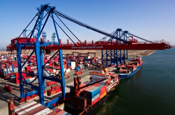
2.1.2 Egypt Port of Port Said
Port Overview
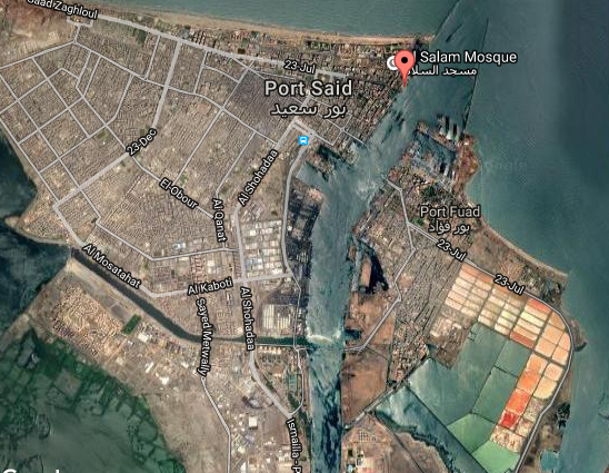
Port Said port is considered one of the most important Egyptian ports on the Mediterranean sea due to its geographical site where it is located on the eastern entrance of the Suez canal, and also on the entrance of the biggest global navigational channel (the Suez Canal) and at the mid of the biggest commercial navigational channel linking Europe with the East and it is also considered biggest crossing traffic port in the world. It is an artificial harbour, well sheltered by breakwaters.
Information on Anchorage, Pilotage, Radio frequencies of the port management and weather conditions of the Port can be found in the following document: Egypt Port Said Additional Information.docx
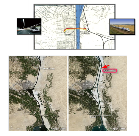
Suez Tunnel Project:
Project of constructing a tunnel under Port Said Suez Canal, consists of 3 tunnels for cars and trains, to achieve a direct link between the east and west of canal and supports the development strategy in Sinai. The project preliminary designs take into account the development, transport and logistics needs of the region for a period of at least twenty years, including the linkage with international roads and the integrated development scheme for axis Suez Canal.
The Suez Canal Authority announced that seven new tunnels will be dug to connect the Sinai Peninsula to the Egyptian homeland. Three tunnels will be dug in Port Said (two for cars and one for railways) and four will be dug in Ismailia (two for cars, one for railways, and one for other special uses). The tunnels will cost 4.2 billion dollars (approximately about 30 billion Egyptian pounds). The first three tunnels will cost 18 billion Egyptian pounds, Arab Contractors Company, Orascom and the armed forced are the main key players in the implementation.
Floating bridge
The Al-Nasr floating bridge to enable people to easily travel back and forth between Port Said and Port Fouad was built successfully and inaugurated in late 2016. The bridge extends from opposite banks, with the help of tugboats that push both parts until they connect to form a bridge that can be traversed by cars. It is 420 meters long. This was an important step towards the efficient movement of equipment and manpower.
Key port information can also be found at: Website of the Maritime Database on the Port Said
Port website: Port Said sea port webpage
|
Port Location and Contacts |
|
|
Country |
Egypt |
|
Province or District |
n/a |
|
Town or City (Closest location) with Distance (km) |
Name: Port Said Distance: 8km |
|
Port's Complete Name |
Port Said Port |
|
Latitude |
31° 15' N |
|
Longitude |
32° 18' E |
|
Managing Company or Port Authority (If more than one operator, break down by area of operation) |
Port Said Port Authority |
|
Management Contact Person |
n/a |
|
Closest Airport and Frequent Airlines to / from International Destinations |
Airport Name: El Arish International Airport (92.7 miles / 149.2 km) Cairo International Airport (94.3 miles / 151.7 km) El Nouzha Airport (138.2 miles / 222.5 km) Borg El Arab Airport (155.1 miles / 249.6 km) |
Port Picture
Description and Contacts of Key Companies
For more information on Contacts and key companies click here for the website of the Egypt Maritime Transport Sector (MTS).
For more information on port contacts, please see the following link: 4.4 Egypt Port and Waterways Companies Contact List
Port Performance
|
Weather |
Mild |
|
Water Density |
1.025 g/cm3 |
|
Raining Season |
winter |
|
Tidal range and flow |
0.3 m |
|
Total Area |
72.10 km2 (72.100.000 m2) |
|
Water Area |
1.5 km2(1.500.000 m2) |
|
Land Area |
70.6 km2 (70.600.000 m2) |
|
Total Customs Zone |
33.5 km2 (33.500.000 m2) |
|
Total Yards Area |
0.6 km2 (600.000 m2) |
|
Maximum Port Length |
10 km (western port boundary) |
|
Maximum Port Width |
8 km (southern boundary) |
|
Seasonal Constraints |
||
|
|
Occurs |
Time Frame |
|
Rainy Season |
No |
|
|
Major Import Campaigns |
No |
|
|
Other Comments |
||
|
Handling Figures for 2017 |
|
|
Vessel Calls |
1233 |
|
Container Traffic (TEUs) |
800,000 |
Discharge Rates and Terminal Handling Charges
For information on port rates and charges, please see the following link at the MTS website: http://www.mts.gov.eg/ar/agencies/default/index/1-22-Tariff-Services-Agency
Berthing Specifications
|
Berth Type |
Number Berths |
Auxiliary Berths |
Length (m) |
Depth (m) |
|
|
From |
To |
||||
|
Tourist |
3 |
1,2,3 |
400 |
9.6 |
11.3 |
|
General Cargo |
7 |
13,14,16,15,19,20,21 |
910 |
5 |
8.2 |
|
Container |
3 |
23,24,25 |
341 |
13.2 |
13.2 |
|
Grain |
2 |
17,18 |
508 |
12.7 |
12.7 |
|
Multi-Purpose |
5 |
26,27,28, 29,30 |
606 |
13.2 |
13.2 |
|
Petroleum services |
3 |
31,32,33 |
575 |
3.6 |
3.6 |
|
buying (services) |
2 |
11,12 |
245 |
3.6 |
3.6 |
|
Barge and Tug |
4 |
7,8,9,10 |
415 |
3.6 |
3.6 |
|
RORO |
1 |
22 |
40 |
8.2 |
8.2 |
|
Salt Shipping and services |
1 |
34 |
260 |
8.2 |
8.2 |
|
services |
1 |
6 |
100 |
3.6 |
3.6 |
|
Total |
32 |
|
4400 |
|
|
Click here for further narrative about berths available, from the Maritime Transport Sector website.
General Cargo Handling Berths
Maximum Capacity: 6 million ton/year as follows:
- Berth length: 2.4 km - first phase: 1200m + second phase 1200m
- Containerised cargo: 6 million tons
- Containers: 2.2 million TEUs, the volume of containers handled after the completion of the second phase reached 5.1 million TEU
- Ship of depth up to 14.5m is the maximum ship size that can be accommodated.
- Working Hours: throughout 24 Hours.
Port Handling Equipment
The port equipment is managed by the government.
|
Equipment |
Available |
Total Quantity and Capacity Available |
Comments on Current Condition and Actual Usage |
|
Dockside Crane |
Yes |
2 - 1 x 5 t
1 x 7.5 m 1 x 12 t |
n/a |
|
Container Gantries |
n/a |
n/a |
n/a |
|
Mobile Cranes |
Yes |
8 - 2 x 20 t 2 x 12.5 t 2 x 12 t 1 x 24 t 1 x 21 t |
max. reach of 20 m |
|
Reachstacker |
n/a |
n/a |
n/a |
|
RoRo Tugmaster (w/ Trailer) |
n/a |
n/a |
n/a |
|
Grain Elevator w/ Bagging Machines |
n/a |
n/a |
n/a |
|
Transtainer |
n/a |
n/a |
n/a |
|
Forklifts |
n/a |
n/a |
n/a |
Floating cranes with 500 tons lifting capacity on the main hook.
|
MAIN SPECIFICATIONS |
KHALIFA |
BAHGAT/BADAWI |
EMLAK |
ENRAZ |
|
Max. lifting capacity |
40 t |
100 t |
200 t |
500 t |
|
Max. lifting height |
38 m |
40 m |
35 m |
60 m |
|
Outreach: |
15,5 m |
10 m |
8.8 m |
15 m |
|
Main hook |
30 m |
30 m |
28.8 m |
40 m |
|
Aux. Hook |
|
|
|
|
Container Facilities
Customs Guidance
The Customs Department is one of the interests of the Ministry of Finance, and extends its role from the collection of fees and taxes to control the movement of goods imported to the country and goods imported from the country.
The core functions of the Customs can be determined as follows:
- The collection of fees and taxes and other receipts paid by importers and exporters according to the Customs Tariff Act and other relevant laws.
- Protect state revenues, and that by preventing the evasion of duties and ensure payment of fees and taxes due
- Control of warehouses in ports and marine air, and follow-up of raw materials exempted from customs duties
- Supervision on the movement of the stock of goods in the stores of public and private warehouses authorised to store imported goods
- Commitment to implement the decisions and rules and standards issued by the ministries and government departments other in the country such as the Ministry of Agriculture and the Ministry of Commerce and the Ministry of Culture and the Ministry of the Interior, and also the interest of the veterinary quarantine and quarantine, and the Drug Enforcement Administration and management of the inspection of weapons and explosive materials, Ministry of management and internal control over artistic works and publications.
- Of functions that are specific to the Customs Department is to combat smuggling, either to the inside or outside the country through customs, either sea or air, or land. Customs and focus its efforts in following up on all the ports that are expected to occur through smuggling activities taking place in order to avoid paying duties and taxes or to enter drug and prohibited materials into the country, or breach of customs legislation.
- And the customs with the help of other regulatory bodies
to tighten control over the incoming or
outgoing goods, or prohibited.
Examples of such Bodies:
- Ministry of Communications and Information
- Department of Health
- Ministry of the Interior
- Department of State
- Department of Defense
- Drug Enforcement Administration
- Industrial Control Authority
- interest quarantine
- Department of censorship and Publications
- Environmental Protection Agency
- And Customs is working to enhance the performance of customs tariff in various sectors, and through the introduction of new techniques such as pre-release and also the application of risk management techniques widely in various areas of customs.
And all disclosures and inspection of the goods, whether imported or exported by the customs, those goods are dealt with according to special rules for testing adhered to by staff in the departments of customs examination
For more information on customs in Egypt, please see the following link: 1.3 Egypt Customs Information
Terminal Information
MULTIPURPOSE TERMINAL
Latest performance:
- Containerized cargo: 4,735 million tons.
- The number of TEU: 800,000 TEUs.
- Passenger: 0.03 million passengers.
- Container Voiding Rate: 25 containers/hrs.
- Max. Ship Size: 13.2m draft-vessels.
- Working Hours 24 hour daily
GRAIN AND BULK HANDLING
The port is equipped with 12 warehouses for inbounded grain with total space capacity of 17,500 m2 .
MAIN STORAGE TERMINAL
For further information on storage please see the following link on the MTS website:http://www.mts.gov.eg/ar/agencies/default/index/1-22-Tariff-Services-Agency
Hinterland Information
Containers and bulk cargo are being transported outbound mainly by Road (Inland transportation) to other ports or to final consignee, however part of the cargo is being moved by railway to Damietta and Port Said.
Port Security
|
Security |
|
|
ISPS Compliant |
Yes |
|
Current ISPS Level (Level 1 = Normal, Level 2 = Heightened, Level 3 = Exceptional) |
Normal |
|
Police Boats |
yes |
|
Fire Engines |
Yes |
2.1.3 Egypt Port of Damietta
Port Overview
Damietta Port geographical position:
- Damietta port is located 10 km to the west of the Nile River (Damietta Branch), 70 km to the west of port said and 200 km from Alexandria Port.
- Total port area: 11.8 million m2
- Water area: 3.9 million m2, will be increased to 4.3 million m2
- Land area: about 7.9 million m2, will be increased to 8.6 million m2
- Water area to total port area is 1:3
Key port information can also be found at: Website of the Maritime Database on the Port of Damietta
Port website: Damietta sea port webpage
|
Port Location and Contact |
|
|
Country |
Egypt |
|
Province or District |
Damietta |
|
Nearest Town or City with Distance from Port |
Name: Damietta - 10 km |
|
Port's Complete Name |
Damietta Port |
|
Latitude |
31d 29 north |
|
Longitude |
45d 31 east |
|
Managing Company or Port Authority |
General Authority for Damietta Port |
|
Management Contact Person |
Admiral / Ayman Saleh |
|
Nearest Airport and Airlines with Frequent International Arrivals/Departures |
|
Port Picture

Description and Contacts of Key Companies
For more information on Contacts and key companies click here for the relevant page on the Damietta port website.
For more information on port contacts, please see the following link: 4.4 Egypt Port and Waterways Companies Contact List
Port Performance
For more information please see the following attachment: Egypt Damietta Port Additional Information.pdf
|
Seasonal Constraints |
||
|
|
Occurs |
Time Frame |
|
Rainy Season |
Yes |
From (December ) to (February ) |
|
Major Import Campaigns |
No |
N/A |
|
Other Comments |
N/A |
|
|
Handling Figures for 2017 |
|
|
Vessel Calls |
2832 |
|
Container Traffic (TEUs) |
1,131,226 |
|
Handling Figures Bulk and Break Bulk for 2017 |
|
|
Bulk (MT) |
16,664,133 |
|
Break bulk (MT) |
4,651,033 |
Discharge Rates and Terminal Handling Charges
For information on port rates and charges, please see the following link for the port website: https://www.dpa.gov.eg/
Berthing Specifications
For information see attachment 2017 Yearly Report Damietta Port
Click here for further narrative about berths available on the port website.
General Cargo Handling Berths
For information click here
Port Handling Equipment
For information click here
Container Facilities
Customs Guidance
For more information on customs in Egypt , please see the following link: 1.3 Egypt Customs Information
Terminal Information
MULTIPURPOSE TERMINAL
For information click here
GRAIN AND BULK HANDLING
For information click here
MAIN STORAGE TERMINAL
For information click here
Hinterland Information
The port is connected to the main transportation network:
- Railways (Damietta – Almansoura)
- Roads (HighWay-Damietta-Almansoura)
- Rivers (The river nile is connected to the port via navigational barge channel)
Port Security
|
Security |
|
|
ISPS Compliant |
Yes |
|
Current ISPS Level (Level 1 = Normal, Level 2 = Heightened, Level 3 = Exceptional) |
1 |
|
Police Boats |
Yes |
|
Fire Engines |
Yes |
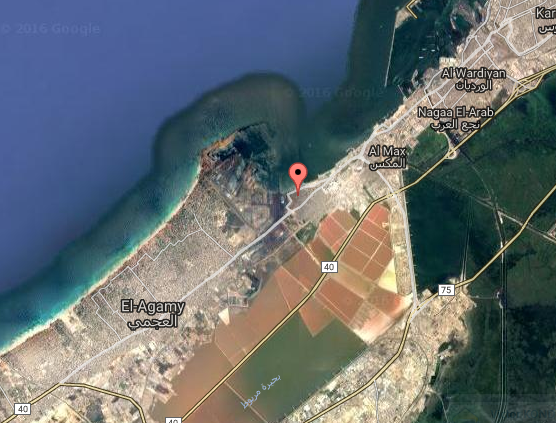
2.1.4 Egypt Port of Dekheila
Port Overview
Alexandria Maritime Port occupies the leading position in the ports of the Arab Republic of Egypt with regard to the volume of trade movement, through which about 60% of Egypt’s foreign trade is traded. Alexandria is located on the western edge of the Nile between the Mediterranean Sea and Lake Mariout. Alexandria is the second most important city in the Arab Republic of Egypt and its main port.
Dekheila port is a natural extension to Alexandria Port; constructions started in 1980 and the port operated partially in 1986 by operation of minerals berth. El-Dekheila port takes the place of the former Dekheila airport westward Alexandria port with 7 km. from sea and 10 km.
Key port information can also be found at: Website of the Maritime Database on the Port of Dekheila
Port website: http://newapa.alexandria-port.com/en/page/eldekhila-port-details/
|
Port Location and Contacts |
|
|
Country |
Egypt |
|
Province or District |
Delta |
|
Town or City (Closest location) with Distance (km) |
Name: Alexandria km: 8 |
|
Port's Complete Name |
El-Dekheila |
|
Latitude |
31° 11' 36.9492" North |
|
Longitude |
29° 52' 34.5252" East |
|
Managing Company or Port Authority (If more than one operator, break down by area of operation) |
Dekheila Port Authority |
|
Management Contact Person |
Tel: +20 3 440 8395 Fax: +20 3 480 8397 |
|
Closest Airport and Frequent Airlines to / from International Destinations |
Airport Name: Borg El Arab Airlines: Egypt Air |
Port Picture
Description and Contacts of Key Companies
For more information on Contacts and key companies click here for the website of the General Authority of Alexandria Port
For more information on port contacts, please see the following link: 4.4 Egypt Port and Waterways Companies Contact List
Port Performance
|
Seasonal Constraints |
||
|
|
Occurs |
Time Frame |
|
Rainy Season |
Yes |
From December to February |
|
Major Import Campaigns |
No |
N/A |
|
Other Comments |
Wind direction north west with velocity in summer 2-3 on beaufort scale and 3-4 in winter |
|
|
Handling Figures for 2017 |
|
|
Vessel Calls |
4232 |
|
Container Traffic (TEUs) |
1 million |
|
Handling Figures Bulk and Break Bulk for 2017 |
|
|
Bulk (MT) |
6.41 million |
|
Break bulk (MT) |
|
For further structural information of El-Dekheila Port please the following attachment: Additional information - Port of Dekheila.docx
Discharge Rates and Terminal Handling Charges
For information on port rates and charges, please see the following link on the port website: LINK TO PORT RATES/TARIFFS PAGE on the port authority website.
Berthing Specifications
|
Type of Berth |
Quantity |
Length (m) |
Maximum Draft (m) |
Comments |
|
Conventional Berth |
48 |
6532 |
12.81 |
|
|
Container Berth |
4 |
732 |
12.49 |
|
|
Silo Berth |
3 |
695 |
10.00 |
|
|
Berthing Tugs |
68 |
Na |
Na |
|
|
Water Barges |
NA |
Na |
Na |
|
Click
here for further narrative about
berths available on the port website.
General Cargo Handling Berths
|
Cargo Type |
Berth Identification |
|
Imports - Bagged Cargo |
1/5-2/5-3/5-4/5-9-10- 11-12-13-14-25-26-27- 28-35-36-37-38-39-40- 41-42-43-44-82 |
|
Exports - Bagged Cargo |
Same as above |
|
Imports and Exports - RoRo |
25/26 M |
|
Other Imports |
3 |
Port Handling Equipment
The port equipment is managed by the government.
Alexandria Container Handling Company (ACH) and operating companies in this field. The total area of the container terminal is 163,000 m2, total capacity 230,000 containers. It is possible to increase the capacity to reach up to 300,000 when a 5 tera stacking system is adopted. The terminal is equipped with huge handling and stevedoring equipment
Container Facilities
Customs Guidance
For more information on customs in Egypt, please see the following link: 1.3 Egypt Customs Information
Terminal Information
MULTIPURPOSE TERMINAL
For more information click here for the port website.
GRAIN AND BULK HANDLING
For more information click here or the port website.
MAIN STORAGE TERMINAL
For more information click here or the port website.
Port Security
|
Security |
|
|
ISPS Compliant |
Yes |
|
Current ISPS Level (Level 1 = Normal, Level 2 = Heightened, Level 3 = Exceptional) |
1 |
|
Police Boats |
Yes |
|
Fire Engines |
Yes |
2.1.5 Egypt Port of Suez
Port Overview
The port is located on the northern part of Suez Gulf on the southern gate of Suez Canal. it is bordered by an imaginary line extending from Ras Masala to Ras El-Sadat. It includes the northern coast until Suez Canal entrance. Bordered by an imaginary line extending 140 degrees from the extremity of the eastern breakwater until the western breakwater. It consists of three sections:
- Suez Port
- Adabya Port
- Petroleum dock
Port website: Suez sea port webpage
Key port information can also be found at: https://www.maritime-database.com/
For more information aboutSuez Port please see the following attachment
|
Port Location and Contacts |
|
|
Country |
Egypt |
|
Province or District |
Suez |
|
Town or City (Closest location) with Distance (km) |
Suez - 8km |
|
Port's Complete Name |
Suez Port |
|
Latitude |
29° 58' N |
|
Longitude |
32° 33' E |
|
Managing Company or Port Authority |
Red Sea Port Authority |
|
Management Contact Person |
n/a |
|
Closest Airport and Frequent Airlines to / from International Destinations |
Airport Name: Cairo Int Airport - 120 km |
Port Picture
Description and Contacts of Key Companies
For more information on Contacts and key companies click here for the Suez Canal website.
For more information on port contacts, please see the following link: 4.4 Egypt Port and Waterways Companies Contact List
Port Performance
|
Water Area |
158 km2 - Including Suez, Adabiya, and Petroleum Dock |
|
Land Area |
2.3 km2 |
|
Total Warehouses Area |
23,976 m2 |
|
Total Yards Area |
500 m2 |
|
Navigation channels length |
1,000 m |
|
Navigation channels depth |
12 m |
Maximum Capacity :
- 6.6 million tons (general cargo) yearly
- 1.5 million Passenger yearly
- Maximum Ship Received Vessels with draft 8 m
- Working Hours: throughout 24 hours (in 3 shifts)
Navigation:
Approach Area - vessels usually berth at the dwelling area. Dredging of the fairway at new Sakhra port and the coastal cape has rendered water depth consistent, estimated at 11.28 m. During tide, vessels up to 11.25 m. draft can approach the harbour during the flow taking the consideration that the draft not exceeding 12.19 m
Pilotage - Pilotage is compulsory, and it is monitored though radio (VHF – H/F) and electronic equipment (Radar Beacon). Senior Pilots - 6; Second Pilotage - 1; Third Pilotage - 2.
For further information please see the following attachment: Egypt Suez Port Additional Information
|
Seasonal Constraints |
||
|
|
Occurs |
Time Frame |
|
Rainy Season |
Yes |
From (December) to (February ) |
|
Major Import Campaigns |
NO |
|
|
Other Comments |
||
|
Handling Figures for 2018 |
|
|
Vessel Calls |
2137 |
|
Container Traffic (TEUs) |
N/A |
|
Handling Figures Bulk and Break Bulk for 2018 |
|
|
Bulk (MT) |
18,670,000 |
|
Break bulk (MT) |
Included in above figure |
Discharge Rates and Terminal Handling Charges
For information on port rates and charges, please see the following link: LINK TO PORT RATES/TARIFFS PAGE
Berthing Specifications
|
Type of Berth |
Quantity |
Length (m) |
Maximum Draft (m) |
Comments |
|
Conventional Berth |
48 |
6532 |
12.81 |
|
|
Container Berth |
4 |
732 |
12.49 |
|
|
Silo Berth |
3 |
695 |
10.00 |
|
|
Berthing Tugs |
68 |
N/a |
N/a |
|
|
Water Barges |
N/a |
N/a |
N/a |
|
Berths Information according to their types
|
Berth Type |
Number of Berths |
Length (m.) |
Depth (m.) |
|
|
From |
To |
|||
|
Passenger |
5 |
750 |
8.00 |
8.00 |
|
Passenger / cargo |
7 |
1320 |
7.50 |
7.50 |
|
Total |
12 |
2070 |
- |
- |
Click
here for further narrative from the
Maritime Transport Sector (MTS) website about berths
available.
General Cargo Handling Berths
|
Cargo Type |
Berth Identification |
|
Imports - Bagged Cargo |
1/5-2/5-3/5-4/5-9-10- 11-12-13-14-25-26-27- 28-35-36-37-38-39-40- 41-42-43-44-82 |
|
Exports - Bagged Cargo |
Same as above |
|
Imports and Exports - RoRo |
25/26 M |
|
Other Imports |
3 |
Port Handling Equipment
Port equipment is managed by the government.
Cranes: Floating cranes with lifting capacity up to 500 tons on the main hook, and up to 1400 tons on the boat davit, two cranes of 70 tons, eleven of 10-30 tons, more than 50 forklifts of 4 tons and 2 of 25 tons. 2 derricks - 60 tons and 120 tons.
Provisions: ISSA members available
|
Equipment |
Available |
Total Quantity and Capacity Available |
Comments on Current Condition and Actual Usage |
|
Dockside Crane |
Yes |
500 mt |
|
|
Container Gantries |
Yes |
2x 70 tom 11x 10l30 tons |
|
|
Mobile Cranes |
Yes |
Not available |
|
|
Reach stacker |
Yes |
2 ( 50 / 120 ton) |
|
|
RoRo Tugmaster (with Trailer) |
Yes |
Not available |
|
|
Grain Elevator with Bagging Machines |
Yes |
N/a |
Available in the local market for rentals |
|
Transtainer |
Yes |
N/a |
|
|
Forklifts |
Yes |
50 |
|
Capacity of CFS: 620,000 TEUs/ year
Container Facilities
|
Facilities |
20 ft |
40 ft |
|
Container Facilities Available |
No |
No |
|
Container Freight Station (CFS) |
No |
No |
|
Refrigerated Container Stations |
No |
No |
|
Other Capacity Details |
N/a |
N/a |
|
Daily Take Off
Capacity |
N/a |
N/a |
|
Number of Reefer
Stations |
N/a |
N/a |
|
Emergency Take-off Capacity |
N/a |
N/a |
|
Off take Capacity of Gang
Shift |
N/a |
N/a |
Terminal Information
GRAIN AND BULK HANDLING
|
Number of Berths |
Type |
Draft |
|
1 |
Grains |
42 Ft |
|
3 |
General Cargo |
36 Ft |
|
1 |
General Cargo /Cement |
36 Ft |
|
1 |
Grains |
36 Ft |
|
1 |
Lighters |
27 Ft |
|
1 |
General Cargo |
33 Ft |
|
1 |
General Cargo/Cement |
42 Ft |
MAIN STORAGE TERMINAL
Sheds Storage Areas of 17,767 m2 as follows:
|
Cement |
5,472 m2 |
|
Tobacco |
2,180 m2 |
|
General Cargo |
10,115 m2 |
|
Open Storge Area |
23,000 m2 |
|
Areas For Containers |
5,000 m2 approximately |
|
Areas For Cars |
2,500 m2 approximately |
|
Storage Type |
Number of Storage Facilities |
Area (m2) |
|
Bagged Cargo |
|
18615 |
|
Refrigerated Cargo |
|
N/A |
|
General Cargo |
|
280000 |
Port Security
|
Security |
|
|
ISPS Compliant |
Yes |
|
Current ISPS Level (Level 1 = Normal, Level 2 = Heightened, Level 3 = Exceptional) |
1 |
|
Police Boats |
Yes |
|
Fire Engines |
Yes |
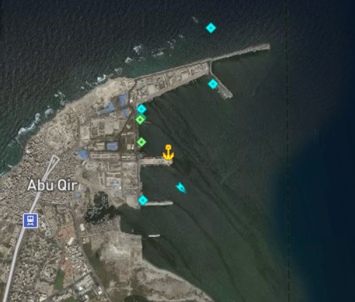
2.1.6 Egypt Port of Abu Qir
Port Overview
Located at the very east side of Alexandria city, situated approx. 20 km NE of Alexandria. Admiralty chart: 2681 Admiralty Pilot: 49 Approach: Vessels proceeding to Abu Kir Bay from a westerly direction should keep well to the north of Sultan Shoal and Culloden Reef. Anchorages: Anchorages for large vessels can be obtained in Abu Kir Bay about 1,5 miles off the southern extremity of Geziret Disuqi (Nelson Island) bearing 270 degrees, in a depth of 15 m. Accommodation: Five quays with a total length of 1500 m and depth alongside of 5 m. Large vessels unloading grain are handled in Abu Kir Bay. Bulk Cargo facilities: Grain silo, converted from a bulk carrier, permanently moored at the quayside in the harbor. Equipment includes conveyor belts, cranes and an automatic packaging system for cereals.
Terminals: Mainly used for food products, urea, petroleum offshore activities and some project cargoes also and a lot of citrus exporting activities.
Port website: Abu Qir sea port webpage
Key port information can also be found at: Website of the Maritime Database on the Port of Alexandria
|
Port Location and Contacts |
|
|
Country |
Egypt |
|
Province or District |
Delta |
|
Town or City (Closest location) with Distance (km) |
Name: Delta km: n/a |
|
Port's Complete Name |
n/a |
|
Latitude |
31° 19' N |
|
Longitude |
30° 04' E |
|
Managing Company or Port Authority (If more than one operator, break down by area of operation) |
Alexandria Port Authority |
|
Management Contact Person |
n/a |
|
Closest Airport and Frequent Airlines to / from International Destinations |
|
Port Picture
Description and Contacts of Key Companies
For more information on Contacts and key companies clickhere for the Alexandria Port website.
For more information on port contacts, please see the following link: 4.4 Egypt Port and Waterways Companies Contact List
Port Performance
|
Seasonal Constraints |
||
|---|---|---|
|
Occurs |
Time Frame |
|
|
Rainy Season |
Yes |
From December to February |
|
Major Import Campaigns |
No |
n/a |
Discharge Rates and Terminal Handling Charges
For information on port rates and charges, please see the following link: LINK TO PORT RATES/TARIFFS PAGE .
Berthing Specifications
Click here for further narrative about berths available at the Marine Traffic website.
Port Handling Equipment
The port equipment is managed by the government.
Customs Guidance
For more information on customs in Egypt, please see the following link: 1.3 Egypt Customs Information
Terminal Information
MULTIPURPOSE TERMINAL
Primarily used by naval vessels, commercial activity includes the handling of dry bulk, metals and foodstuffs.
Hinterland Information
Common mean of transportation is by land.
Port Security
|
Security |
|
|
ISPS Compliant |
Yes |
|
Current ISPS Level (Level 1 = Normal, Level 2 = Heightened, Level 3 = Exceptional) |
1 |
|
Police Boats |
No |
|
Fire Engines |
Yes |
2.1.7 Egypt Port of Sidi Kerir
Port Overview
Situated 27km south-west of Alexandria, tanker terminal at north end of Suez Mediterranean pipeline. Admiralty chart: 3325 Admiralty pilot: 49 Pilotage: Compulsory Radio Information: All messages to be sent via Alexandria/Port Said radio stations Sidi Kerir has an HF long range Radio working on 2182 and 4142,5khz. VHF ch. 16 and 78. Accommodation: Five berths for tankers at SBM can accommodate tankers up to 150000 dwt and 15.8 m max. draft, and two SBM can accommodate tankers up to 400000 dwt and 22.9 m max. d. All buoys are equipped with deballasting sea lines leading to a water treatment system onshore. Storage: Onshore facilities include (15) Double - Deck floating roof welded steel storage tanks, total storage cap. of 1,500,000 m³. Bunkers: Not available. Towage: Available.
Key port information can also be found at: Website of the Maritime Database on the Sidi Kerir Terminal
|
Port Location and Contacts |
|
|
Country |
Egypt |
|
Province or District |
Delta |
|
Town or City (Closest location) with Distance (km) |
Name: Alexandria km: n/a |
|
Port's Complete Name |
n/a |
|
Latitude |
31° 06' N |
|
Longitude |
29° 37' E |
|
Managing Company or Port Authority (If more than one operator, break down by area of operation) |
SUMED - Arab Petroleum Pipelines Co |
|
Management Contact Person |
Tel: +20 3 586 6723 Fax: +20 3 586 1295 |
|
Closest Airport and Frequent Airlines to / from International Destinations |
|
Port Picture
Port Performance
Sidi Kerir terminal consists of 30 floating roof storage tanks of 3.3 million m3 total capacity:
- 15 tanks of 103,000 m3 each.
- 15 tanks of 117,000 m3 each.
The crude oil loading system comprises of five
pumping stations, each pump
station consists of 3 pump units and is designated to one group of
tanks. The loading system is designed to simultaneously load four
crude oil grades on five vessels at maximum flow rates. Five
turbine meter banks and dual automatic sampler systems are
downstream of the pumping stations for the custody transfer
measurement. Crude is delivered to the tankers via six SBMs capable
of accommodating tankers of up to 400,000 dead weight
tons:
- 1 buoy up to
400,000 dead weight tons.
- 2
buoys up to 350,000 dead weight
tons.
- 3 buoys up to 150,000
dead weight tons.
Description and Contacts of Key Companies
4.4 Egypt Port and Waterways Companies Contact List
Customs Guidance
2.1.8 Egypt Port of Abu Zenima
Port Overview
Situated on eastern shore of the Gulf of Suez, 104 km SE of Suez.
Largest vessel: 152 m length, 20,40 m wide, 7,62 m draft. Height from water line to top of hatch or rail should not exceed 9,75 m.
Vessels may lie alongside pier head for bowhawsers, a screwpile pier extends 133,5 m SSE from shore. A concrete pier with a shore crane eastward of pier. Situated on eastern shore of the Gulf of Suez, 104 km SE of Suez. Admiralty chart: 753Admiralty Pilot: 64Approach: Abu Zenima bay is entered between Ras Abu Zenima and Cairn Point and has a draft of over 18.3 m. A sand bank extends off shore about 1295 m from Ras Abu Zenima, marked by a conical buoy; on east side, edge of bank is about 185 m from pier head.
Key port information can also be found at: Website of the Maritime Database on Abu Zenima Port
|
Port Location and Contacts |
|
|
Country |
Egypt |
|
Province or District |
Delta |
|
Town or City (Closest location) with Distance (km) |
Name: Cairo km: n/a |
|
Port's Complete Name |
n/a |
|
Latitude |
29° 02' N |
|
Longitude |
33° 07' E |
|
Managing Company or Port Authority (If more than one operator, break down by area of operation) |
Sinai Manganese Co SAE |
|
Management Contact Person |
n/a |
|
Closest Airport and Frequent Airlines to / from International Destinations |
Airport Name: n/a Airlines: n/a |
Description and Contacts of Key Companies
4.4 Egypt Port and Waterways Companies Contact List
Customs Guidance
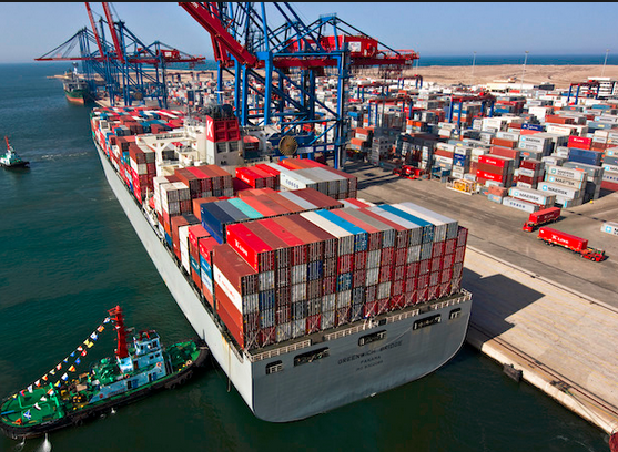
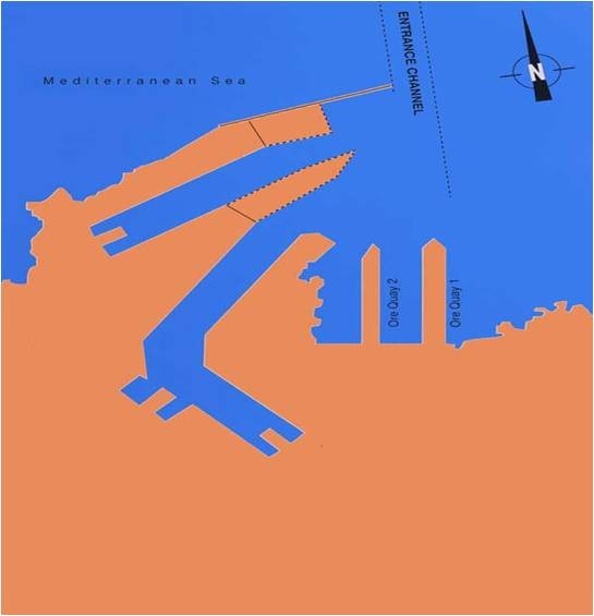
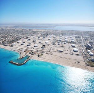
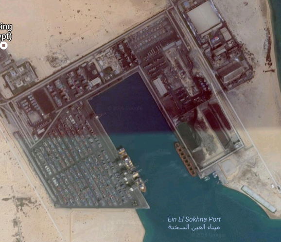
2.1.9 Egypt Port of Al Sokhna
Port Overview
Ain Sokhna is located about 40 km south of Suez on the Red Sea. The port is built at an excellent location on the coast of the gulf of Suez, with Cairo located some 130 km to the west.
The Egyptian government has allocated 9,000 hectares of land for economic and industrial development. This area is referred to as the Suez Special Economic Zone (S.S.E.Z.).
Operations in the port started in 2002. To be able to meet the cargo handling demands in the future, a Masterplan has been developed that shows the development of the Sokhna port up to 2020.
Port website: Website of the Al Sokhna Port
Key port information can also be found at: Website of the Maritime Database on Al Sokhna Port
|
Port Location and Contacts |
|
|
Country |
Egypt |
|
Province or District |
Red Sea |
|
Town or City (Closest location) with Distance (km) |
Name: Cairo km: 120 |
|
Port's Complete Name |
Ain Sokhna |
|
Latitude |
29° 35' N |
|
Longitude |
32° 20' E |
|
Managing Company or Port Authority (If more than one operator, break down by area of operation) |
DP WORLD |
|
Management Contact Person |
Dahlia Galal |
|
Closest Airport and Frequent Airlines to / from International Destinations |
Airport Name: Cairo Airlines: Egyptair |
Port Picture
Port Performance
|
Seasonal Constraints |
||
|
|
Occurs |
Time Frame |
|
Rainy Season |
No |
N/a |
|
Major Import Campaigns |
No |
N/a |
|
Other Comments |
N/a |
|
Berthing Specifications
|
Berth Type |
Number of Berths |
Length (m) |
Width (m) |
depth (m) |
|
Ro Ro |
2 |
200 |
30 |
17 |
|
Bulk & General |
1 |
750 |
30 |
17 |
|
Container |
1 |
750 |
30 |
17 |
|
Tug Craft |
1 |
200 |
- |
5.5 |
|
Assisting units |
1 |
100 |
- |
5.5 |
|
Third dock |
1 |
350 |
- |
17 |
|
Total |
7 |
2350 |
- |
- |
Container Storage Area:
- Container terminal yard space is 41 ha
- Ground slot 4,600 TEU
- Full Containers capacity are 17,000 TEU
- Empty Containers capacity are 7,000 TEU
- 216 Reefer plug points
- CFS Warehouse space is 4,000 m²
For more information on Sokhna Port please see the following attachment: additional information - Sokhna Port.docx
For more information on contact details (container vessels): https://www.dpworldsokhna.com/contactus.htm
Description and Contacts of Key Companies
4.4 Egypt Port and Waterways Companies Contact List
Customs Guidance
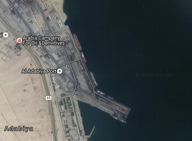
2.1.10 Egypt Port of Adabiya
Port Overview
Situated on the western shore of Suez by, 9 - 6 km south-west of Port Tewfik (Suez Docks). Admiralty chart: 3214 Admiral pilot: 64 Pilotage: Compulsory Largest vessel: 200 m LOA, 12 - 2 m max. D. Accommodation: Consists of ten berths : One used for cement, six Quays for general cargo, and one Quay for small craft. The LOA of berths 100 m - 220 m with draft ranging from 8.23 m - 12.21 m. Cranes: Two 15 t Quay cranes, one 10 t mobile crane, and one 8 t floating crane. Water and provisions: Available. Bunkers: Available. Towage: Available.
Further information in the following document: Egypt Port of Adabiya Additional Information
Key port information can also be found at: Website of the Maritime Database on the Port of Adabiya
|
Port Location and Contacts |
|
|
Country |
Egypt |
|
Province or District |
Suez |
|
Town or City (Closest location) with Distance (km) |
Name: Suez km: n/a |
|
Port's Complete Name |
n/a |
|
Latitude |
29° 52' N |
|
Longitude |
32° 28' E |
|
Managing Company or Port Authority (If more than one operator, break down by area of operation) |
Red Sea Ports Authority |
|
Management Contact Person |
n/a |
|
Closest Airport and Frequent Airlines to / from International Destinations |
Airport Name: Cairo |
Description and Contacts of Key Companies
4.4 Egypt Port and Waterways Companies Contact List
Customs Guidance
Port Security
|
Security |
|
|---|---|
|
ISPS Compliant |
Yes |
|
Current ISPS Level (Level 1 = Normal, Level 2 = Heightened, Level 3 = Exceptional) |
1 |
|
Police Boats |
Yes |
|
Fire Engines |
Yes |
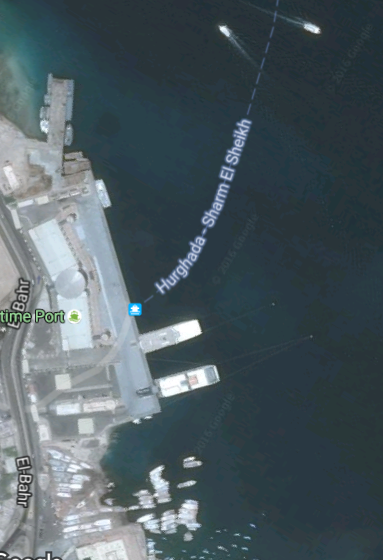
2.1.11 Egypt Port of Hurghada
Port Overview
The port is situated on the western coast of Red Sea near the Gulf of Suez entrance and 370 km. south Suez.
Situated 0.5 miles south west of Franken Point. Admiralty chart: 3043 Admiralty Pilot: 64 Approach: Gifatin channel is entered from the north between Franken Point and the reef, 1.5 km east south east and from the south between Sha'b El-Lug and Umm-Agawish El-Kerir. Min depth in channel 7.3 m. Anchorage: Anchorage is obtainable in 16-18 m. Weather: Strong north winds can create considerable sea. Largest vessel: 100 m LOA and 7.32 m maximum draft.
The significant role of Hurghada port is a result of its distinctive location and the service it provides for international tourism and yacht tourism in Red Sea area as well as serving cruise vessels and shipping lines transporting tourists and passengers from Saudi Arabia and Gulf countries to Sharm El Sheikh Port.
Information on passenger facilities, Approach, Anchorages and Radio frequencies can be found in the following document: Egypt Port of Hurghada Additional Information
Key port information can also be found at: Website of the Maritime Database on the Port of Hurghada
|
Port Location and Contacts |
|
|---|---|
|
Country |
Egypt |
|
Province or District |
Red Sea |
|
Town or City (Closest location) with Distance (km) |
Hurghada |
|
Port's Complete Name |
Port of Hurghada |
|
Latitude |
27° 15' N |
|
Longitude |
33° 49' E |
|
Managing Company or Port Authority (If more than one operator, break down by area of operation) |
Red Sea Port Authority |
|
Closest Airport and Frequent Airlines to / from International Destinations |
Abu Rudeis - 5 km |
Port Picture
Two piers with a hauling off buoy south of it. North pier is wooden with a T shaped head. South is 150 m long with depth of 12 m alongside its head. Vessels berth alongside with an anchor south east and a hawser from the stern to the hauling off buoy. Provisions: Available. Water: Available. Tanker terminals: Tankers normally berth at the north pier and the south pier is connected by pipelines to the oil tanks. Medical facilities: Available. Airports: Available.
Description and Contacts of Key Companies
4.4 Egypt Port and Waterways Companies Contact List
Port Handling Equipment
Single buoy mooring connected to the shore by submarine pipelines. Depth at berth is 35 m.berthing of vessels takes place during daylight hours, unberthing any time. Vessels must be equipped with 10 t. cap. Cranes. Loading rate 5000 t/h via 16'' hoses. Ballast facility is available.
There is a service jetty protected by breakwaters, for vessels of up to 6.5 md.
Provisions and water: Not available.
Bunkers: Available.
Towage: Available.
Medical facilities: Available.
Customs Guidance
2.1.12 Egypt Port of Ras Gharib
Port Overview
A natural port situated on the west shore of the Gulf of Suez.
Admiralty chart: 753
Admiralty Pilot: 64
Anchorages: Vessels can safely anchor in depth of over 9 m.
Pilotage: Compulsory
Radio Frequency/Information: VHF Ch 16, 4 and 2
Weather: North winds most of the year and occasionally short South gales making anchorage impossible.
Key port information can also be found at: Website of the Maritime Database on the Port of Ras Gharib
|
Port Location and Contacts |
|
|
Country |
Egypt |
|
Province or District |
Delta |
|
Town or City (Closest location) with Distance (km) |
Name: Cairo km: n/a |
|
Port's Complete Name |
n/a |
|
Latitude |
28° 21' N |
|
Longitude |
33° 07' E |
|
Managing Company or Port Authority (If more than one operator, break down by area of operation) |
Egyptian General Petroleum Co |
|
Management Contact Person |
n/a |
|
Closest Airport and Frequent Airlines to / from International Destinations |
Airport Name: n/a Airlines: n/a |
Description and Contacts of Key Companies
4.4 Egypt Port and Waterways Companies Contact List
Berthing Specifications
Tanker terminal sheltered by a cape and a chain of reefers. Three loading piers for crude oil. Northern pier, depth alongside 8.23 m, max permissible length of vessel 137 m, max draft 7.32 m, loading rate of 650 t/h. Central pier, depth alongside 10.97 m max. loa 183 m, max draft 9.75 m, loading rate 1200 t/h.
Berthing and unberthing during daylight hours only. Ballast facility is available
Southern pier, depth alongside 23.71 m, max loa 299 m, max draft 16.75 m, loading rate 2000 t/h. The diameter of the crude oil loading lines at the three berths are 18 inches, 18 inches and 30 inches respectively.
Provisions and Fresh Water: Available.
Towage: Not required.
Customs Guidance
2.1.13 Egypt Ras Shukheir Port
Port Overview
Situated on the West shore of the Gulf of Suez. Admiralty chart: 2374 Admiralty pilot: 64 Approach: Vessels may only approach from the (E) and if necessary, anchor (SE) of the sea berth. Under no circumstances should vessels anchor (N) of the sea berth.
Anchorages: Tankers should only anchor in the Ras Shukheir anchorage area which is defined as position 28 16' 25'' N, 33 33' 00''E, in a depth of 66 m. Pilotage is compulsory.
Key port information can also be found at: Website of the Maritime Database on the Port of Ras Shukheir
|
Port Location and Contacts |
|
|
Country |
Egypt |
|
Province or District |
Delta |
|
Town or City (Closest location) with Distance (km) |
Cairo |
|
Port's Complete Name |
n/a |
|
Latitude |
28° 08' N |
|
Longitude |
33° 17' E |
|
Managing Company or Port Authority (If more than one operator, break down by area of operation) |
Egyptian General Petroleum Co |
|
Management Contact Person |
n/a |
|
Closest Airport and Frequent Airlines to / from International Destinations |
Airport Name: N of Ras Shukheir - 101 km |
Port Picture
Description and Contacts of Key Companies
4.4 Egypt Port and Waterways Companies Contact List
Berthing Specifications
Ras Shukheir consists of two sea berths:
- is located approx. 1707 m offshore in water Depth of approx. 25.6 m and can accommodate vessels up to 350 m LOA.
- is located 0.5 mile (S) of No. 1 in water depth of 27.4 m and can accommodate vessels up to 305 m LOA.
Max crude oil loading rate at berth No1 is approx. 55000 bph and at No.2 is 51000 bph. Berthing takes place during daylight, unberthing anytime. There is a ballast facility available. Tankers must have at least 150 fathoms of anchor chain as minimum. Vessels leaving Ras Shukheir oil terminal should time their departure to avoid impeding the navigation of ships approaching in the southbound lane.
Provisions and water: Not Available.
Bunkers: Not Available.
Liquefied Gas Terminals: One berth for loading Gas By pump.
Towage: Available.
Medical facilities: Available.
Customs Guidance
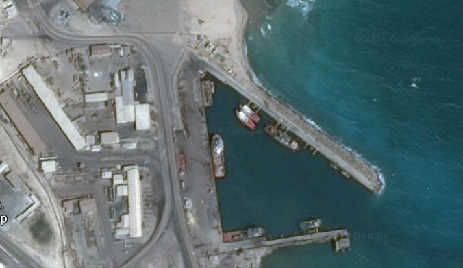
2.1.14 Egypt Safaga Port
Port Overview
The port is located in the Red Sea Governorate on the western coast of the Red Sea. It is a broad bay (natural gulf) on a distance of 60 km south of Hurgada and on a distance of 225 nm south of Suez port. This broad bay is naturally protected from the east and the north sides by Safaga Island, and protected from the prevailing western winds by mountains. Yet, for a brief interval, it is affected by south winds (El-Azeeb) which causes disturbances and waves inside the port. The port drafts are deep, thus enabling the accommodation of large vessels.
Admiralty chart: 3043. Admiralty pilot: 64
Pilotage: Compulsory
Weather: Wind light in the morning, gains strength during day, making tying up more difficult.
Largest vessels: 200 m LOA, 12,2 m max. D.
Provisions and water: Water and provisions available.
Ship repairs: Minor repairs possible.
Towage: Available.
Further generic information can be found in the following document: Egypt Safaga Port Additional Information
Key port information can also be found at: Website of the Maritime Database on Safaga Port
|
Port Location and Contacts |
|
|
Country |
Egypt |
|
Province or District |
Suez |
|
Town or City (Closest location) with Distance (km) |
Name: Suez km: n/a |
|
Port's Complete Name |
n/a |
|
Latitude |
26° 44' N |
|
Longitude |
33° 56' E |
|
Managing Company or Port Authority (If more than one operator, break down by area of operation) |
Red Sea Port Authority |
|
Management Contact Person |
n/a |
|
Closest Airport and Frequent Airlines to / from International Destinations |
Airport Name: n/a Airlines: n/a |
Port Picture
Description and Contacts of Key Companies
4.4 Egypt Port and Waterways Companies Contact List
Port Specifications
|
Total Port Area |
57 km2 (56968000 m2) |
|
Water Area |
56.5 km2 (56490000 m2 ) |
|
Land Area |
0.5 km2 (478000 m2) |
|
Total Warehouses Area |
15000 sq. m. |
|
Total Yards Area |
160000 sq. m. |
Maximum Capacity 6.37 million tons/year as follows:
- 2.2 million tons (General Cargo)
- 4.17 .million tons (dry bulk)
- 750000 passengers
- Max Ship Depth that can be accommodated reaches 14m.
- Working Hours:Throughout 24 hours
Berthing Specifications
Consists of five quays : one used for phosphate, two for g/cargo and passenger ferries, one for grain, and one for rock phosphate. Rock phosphate and ground phosphate are loaded at this port for shipment all over the world. Rock phosphate loaded (1000 t/day) from elevator and phosphate in bags by ship's gear. The loading of bulk phosphate is carried out at the company's pier, depth 8.39 m. Grain terminal at depth a/side of 14 m. Silo capacity of 100000 t.
Detailed Berths Information
|
Berth Number |
Length (m.) |
Depth (m.) |
Number of Bollards |
|
Passenger and Cargo |
|||
|
Berth 2 and 3 |
440 |
10 |
- |
|
Bulk |
|||
|
Grain |
290 |
14 |
- |
|
Aluminum Berth |
|||
|
Aluminum Berth |
238 |
10 |
- |
|
Total |
|||
|
4 Berths |
968 |
- |
- |
Further information on Berthing Specifications can be found in the following document: Egypt Safaga Port Additional Information
Customs Guidance
Egypt - 2.1.15 Port of Al-Arish
Updated Assessment as of January 2024
In January 2024, the Logistics Cluster together with the WFP conducted an assessment of Al-Arish Port. Please find the assessment, along with information on relevant Stevedoring Companies at this following links:
Al-Arish Port Assessment (01/24)
Stevedoring Companies Assessment (01/24)
Port Overview
El-Arish port is the only Mediterranean port at the north of Sinai. Until 1982, it was merely a fishing vessel berth. Since 1987, developments were made to protect the port seawards, and to adapt it for fishing activities as well as cargo traffic and transits, crop exportation and different maritime sports, after executing the port development works.
Generic information on the port can be found in the following document: Egypt Arish Port Additional Information
Key port information on the port could be found at: https://www.maritime-database.com/
|
Port Location and Contacts |
|
|
Country |
Egypt |
|
Province or District |
n/a |
|
Town or City (closest location) with Distance (km) |
Name: El Arish; km: n/a |
|
Port's Complete Name |
n/a |
|
Latitude |
31 o 09 / N |
|
Longitude |
33 o 49 / E |
|
Managing Company or Port Authority (If more than one operator, break down by area of operation) |
El Arish Port Authority |
|
Management Contact Person |
n/a |
|
Closest Airport and Frequent Airlines to / from International Destinations |
Airport Name: Cairo Airlines: Egyptair |
Port Picture

Detailed Berths Information
|
Berth Number |
Length (m) |
Depth (m) |
Breadth (m) |
Year of Construction |
Number of Bollards |
|
Dry Bulk |
|||||
|
1 |
242 |
7-8 |
10 |
1984 |
10 |
|
Services and Launches |
|||||
|
2 |
122 |
3-4 |
5 |
1984 |
5 |
|
Total |
|||||
|
2 Berth |
364 |
3-8 |
|
|
|
Port Specifications
|
Total Area |
230,000 m2 |
|
Water Area |
180,000 m2 |
|
Land Area |
50,000 m2 |
|
Total Yards Area |
34,000 m2 |
1.2 million tons / year, including:
- General Cargo: 1.2 million tons/year.
- Max. Ship Size: 8 m. draft-vessels
- Working Hours: 24 hrs. divided to 3 shifts
Description and Contacts of Key Companies
4.4 Egypt Port and Waterways Companies Contact List
Customs Guidance
2.1.16 Egypt Port of Al Tour
Port Overview
Generic information on the port can be found in the following document: Egypt Al Tour Port Additional Information
Key port information can also be at the Maritime Database
|
Port Location and Contacts |
|
|
Country |
Egypt |
|
Province or District |
|
|
Town or City (Closest location) with Distance (km) |
|
|
Port's Complete Name |
Al-Tour Port |
|
Latitude |
28 o 14 / N |
|
Longitude |
33 o 37 / E |
|
Managing Company or Port Authority (If more than one operator, break down by area of operation) |
|
|
Management Contact Person |
|
|
Closest Airport and Frequent Airlines to / from International Destinations |
Airport Name: Sharm el Sheikh Airlines: 82 km |
Port Picture
Description and Contacts of Key Companies
4.4 Egypt Port and Waterways Companies Contact List
Customs Guidance
2.1.17 Egypt Port of Sharm El Sheikh
Port Overview
Key port information can also be found at: Website of the Port of Sharm El Sheikh
|
Port Location and Contacts |
|
|
Country |
Egypt |
|
Province or District |
South Sinai |
|
Town or City (Closest location) with Distance (km) |
Sharm El-Sheikh |
|
Port's Complete Name |
n/a |
|
Latitude |
27 o 51.2 N |
|
Longitude |
34 o 17 E |
|
Managing Company or Port Authority (If more than one operator, break down by area of operation) |
Sharm El-Sheikh Port |
|
Management Contact Person |
n/a |
|
Closest Airport and Frequent Airlines to / from International Destinations |
Airport Name: Sharm el Sheikh Airport Airlines: Egyptair |
Port Picture
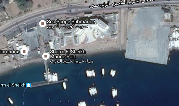
Description and Contacts of Key Companies
4.4 Egypt Port and Waterways Companies Contact List
Customs Guidance
2.1.18 Egypt Port of Nuweibah
Port Overview
Situated on the west shore of the Gulf of Aqaba.
Admiralty chart: 3595.
Admiralty Pilot: 64.
Pilotage: Compulsory.
Towage: Available.
Range of tide: 0.9m.
Berthing and unberthing can be carried out at any time of the day.
Largest vessel:
- 120 m LOA
- 7.32 m Maximum draft
Accommodation:
- Berth No. 1 92 m long and 7.93 m wide
- Berth No. 2 42 m long and 7.83 m wide
- Berth No. 3 120 m long and 7.93 m wide
- Berths 1 and 2 are used by passenger ferries.
- Berth 3 is used by general cargo vessels.
Storage:
- Warehouse of 1,000 m²
- Open yard of 60,000 m².
Further generic information on the port can be found in the following attachment: Egypt Port of Nuweibah Additional Information
Key port information can also be found at: Website of the Maritime Database on the Port of Nuweibah
|
Port Location and Contacts |
|
|
Country |
Egypt |
|
Province or District |
Suez |
|
Town or City (Closest location) with Distance (km) |
Name: Nuweibah km: n/a |
|
Port's Complete Name |
n/a |
|
Latitude |
28° 58' N |
|
Longitude |
34° 38' E |
|
Managing Company or Port Authority (If more than one operator, break down by area of operation) |
Port Authority of Nuweibah |
|
Management Contact Person |
Tel: +20 69 520364 Fax: +20 69 520368 |
|
Closest Airport and Frequent Airlines to / from International Destinations |
Airport Name: Sharm El Sheikh Airlines: Egypt Air |
Port Picture
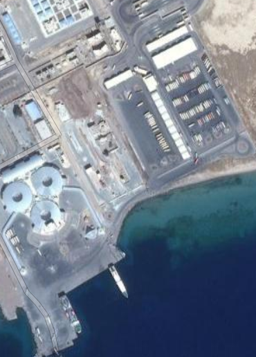
Description and Contacts of Key Companies
4.4 Egypt Port and Waterways Companies Contact List
Customs Guidance
2.1.19 Egypt Petroleum Dock Port
Port Overview
The port is located on the Eastern part of Suez Port on the northern side of Suez Gulf at the southern entrance of Suez Canal.
Maximum capacity:
- Working hour: 24 hours daily
- Liquefied Bulk: 4.14 million tons
For further generic information on the port, please select the following attachment: Egypt Petroleum Dock Additional Information
|
Port Location |
|
|---|---|
|
Country |
Egypt |
|
Province or District |
Suez |
|
Port's Complete Name |
Petroleum Dock Port |
|
Latitude |
29° 57.2' N |
|
Longitude |
32° 31.8' E |
|
Closest Airport and Frequent Airlines to / from International Destinations |
Cairo Airport Airlines: Egyptair |
Description and Contacts of Key Companies
For more information on port company contact details, please see the following link: 4.4 Egypt Port and Waterways Companies Contact List
Discharge Rates and Terminal Handling Charges
For information on the charges for tug and mooring services, port and harbour dues as well as for information on the rates for hiring labour and equipment, please select the following document: Egypt Petroleum Dock Additional Information
Customs Guidance
2.1.20 Egypt Suez Canal
Port Overview
The Suez Canal (In Arabic: Qanat as-Suways), is an artificial sea-level waterway running north to south across the Isthmus of Suez in Egypt to connect the Mediterranean Sea and the Red Sea. The canal separates Africa from Asia, and it provides the shortest maritime route between Europe and the lands lying around the Indian and western Pacific oceans. It is one of the world's most heavily used shipping lanes. The Suez Canal is one of the most important waterways in the world. The canal is extensively used by modern ships, as it is the fastest crossing from the Atlantic Ocean to the Indian Ocean. Tolls paid by the vessels represent an important source of income for the Egyptian Government.
Railway and a sweet water canals run on the west bank parallel to the Suez Canal. The Canal runs between Port Said harbor and the Gulf of Suez, through soils which vary according to the region. At Port Said and the surrounding area, the soil is composed over thousands of years of silt and clay sedimentations deposited by the Nile waters drifted by Damietta branch. This formation extends to Kantara, 40 km to the south of Port Said, where silt mixes with sand. The central region of the Canal between Kantara and Kabret consists of fine and coarse sands, while the southern region contains dispersed layers of rocks, varying in texture from soft sand to some calcium rocks, The side gradient of the water cross section differs according to the nature of the soil, which is 4:1 in the north and 3:1 in the south.
The Suez Canal is a sea level canal and the height of water level differs slightly and the extreme tidal range is 65 cm in the north and 1.9 m in the south. The banks of the canal are protected against the wash and waves, generated by the transit of ships, by revetments of hard stones and steel sheet piles corresponding to the nature of soil in every area. On both sides of the Canal, there are mooring bollards every 125 m for the mooring of vessel in case of emergency, and kilometric sign posts helping locate the position of ships in the waterway. The navigable channel is bordered by light and reflecting buoys as navigational aids to night traffic.
|
Location and Contacts |
|
|---|---|
|
Country |
Egypt |
|
Province or District |
Suez |
|
Town or City (Closest location) with Distance (km) |
Suez -7 km |
|
Complete Name |
Suez Canal |
|
Latitude |
0° 27' 17.99" N |
|
Longitude |
32° 20' 59.99" E |
|
Managing Company or Port Authority (If more than one operator, break down by area of operation) |
Canal Suez Authority |
|
Management Contact Person |
General: Mohab Memesh |
Main Objectives of the New Suez Canal project:
-
Achieving a greater proportion of the duplication of the Suez Canal and increase by 50% of the length of the waterway
-
Reducing transit time to be 11 hours instead of 18 hours for the north convoy
-
Reducing waiting time for ships to be 3 hours in the worst conditions, rather than to be (8 to 11 hours), which is reflected on reducing the cost of the voyage of the ship owners and raising the degree of valuation of Suez
-
Contributing to the increased demand for the use of the Canal corridor major global navigation and increase the degree of classification
-
Increasing the capacity of the passage of ships in the channel to meet the expected growth of the volume of world trade in the future.
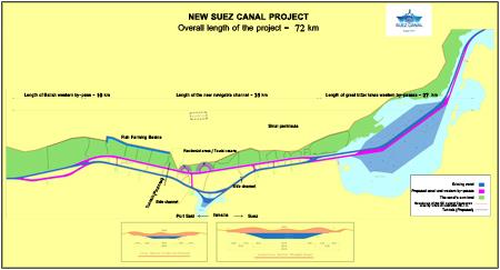
Contributing to the increased demand for the use of the Canal corridor major global navigation and increase the degree of classification. Increasing the capacity of the passage of ships in the channel to meet the expected growth of the volume of world trade in the future. In addition, the project aims to reduce the value of thought in alternative and competitive channels and also raises the degree of confidence in the willingness of Egypt for the successful development of the Suez Canal Area. As a sustainable development driver, the project will provide direct access to the largest number of job opportunities for young people and the creation of new communities.
Operationally, the project aims to increasing the capacity of the channel to be a record 97 ships in 2023 instead of the 49 ships in 2014, achieving direct transit without interruption for 45 vessels in both directions with the possibility of allowing for the transit vessels up to 66 feet in all parts of the channel, and increase the Suez Canal return of 259% in 2023 to be 13,226 billion dollars, compared to the current returns $ 5.3 billion resulting in a direct positive reflection on the Egyptian national income of hard currency.
Description and Contacts of Key Companies
4.4 Egypt Port and Waterways Companies Contact List
Customs Guidance
2.1.21 Egypt Port of East - Port Said
Port Overview
East Port Said Port has a distinguished location east of the northern entrance of the Suez Canal, at the confluence of three continents, and at the crossroad of the most important world sea trade route between the east and the west. The port is bordered from the North by the Mediterranean Sea, from South by the industrial zone, from East by El-Malaha Lake, and from the Western verge of Suez Canal inside the frontiers of Port Said Province
Port information: http://www.worldportsource.com/ports/EGY_Port_Said_135.php
Key port information may also be found at: https://www.maritime-database.com/
|
Port Location and Contact |
|
|
Country |
Egypt |
|
Province or District |
Port Said |
|
Nearest Town or City with Distance from Port |
Port Said - 7 km |
|
Port's Complete Name |
East Port Said Port |
|
Latitude |
31 o 13 / N |
|
Longitude |
32 o 21 / E |
|
Managing Company or Port Authority |
Suez Canal Authority |
|
Management Contact Person |
066/3230836 - 3230826 - 3230821 - 3230813 - 3230822 |
|
Nearest Airport and Airlines with Frequent International Arrivals/Departures |
Cairo International Airport ( 150 KM) El Arish International Airport ( 151 KM) Egypt Air |
Port Picture
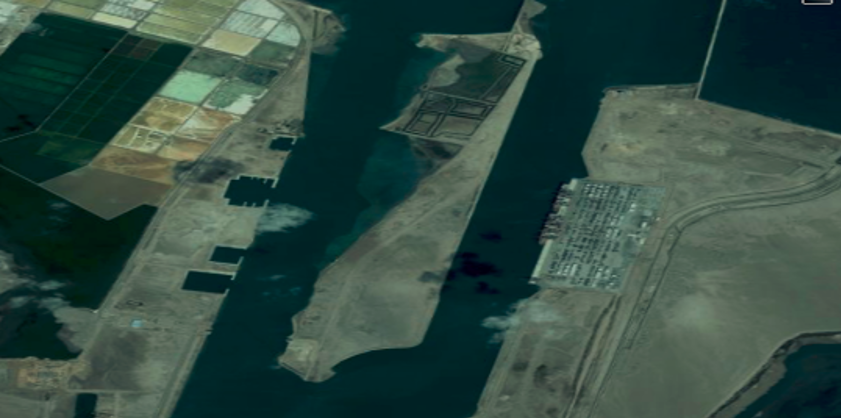
Description and Contacts of Key Companies
For more information on port contacts, please see the following link: 4.4 Egypt Port and Waterways Companies Contact List
Port Performance
Port Specifications
|
Total Area |
72.10 km2 (72,100,000 m2) |
|
Water Area |
1.5 km2 (1.500.000 m2) |
|
Land Area |
70.6 km2 (70.600.000 m2) |
|
Total Customs Zone |
33.5 km2 (33.500.000 m2) |
|
Total Yards Area |
0.6 km2 (600.000 m2). |
|
Maximum Port Length |
10 km (western port boundary) |
|
Maximum Port Width |
8 km (southern boundary) |
|
Seasonal Constraints |
||
|
|
Occurs |
Time Frame |
|
Rainy Season |
Yes |
From December to March |
|
Major Import Campaigns |
No |
All year |
|
Other Comments |
NA |
|
|
Handling Figures for YEAR |
|
|
Vessel Calls |
1735 |
|
Container Traffic (TEUs) |
2.7 million |
|
Handling Figures Bulk and Break Bulk for YEAR |
|
|
Bulk (MT) |
12.2 million |
|
Break bulk (MT) |
6 million |
Berthing Specifications
|
Type of Berth |
Quantity |
Length (m) |
Maximum Draft (m) |
Comments |
|
Conventional Berth |
N/a |
|
|
|
|
Container Berth |
3 |
1200 |
14.5 |
Width 35m / 19 Bollards |
|
Silo Berth |
N/a |
|
|
|
|
Berthing Tugs |
1 |
|
|
Available |
|
Water Barges |
|
|
|
|
Port Handling Equipment
|
Equipment |
Available |
Total Quantity and Capacity Available |
Comments on Current Condition and Actual Usage |
|
Dockside Crane |
Yes |
18 |
|
|
Container Gantries |
Yes |
94 |
|
|
Mobile Cranes |
Yes |
5 |
|
|
Reachstacker |
Yes |
36 |
|
|
RoRo Tugmaster (with Trailer) |
Yes |
2 |
|
|
Grain Elevator with Bagging Machines |
Yes |
N/a |
|
|
Transtainer |
Yes |
2 |
|
|
Forklifts |
Yes |
3 |
|
Container Facilities
|
Facilities |
20 ft |
40 ft |
|
Container Facilities Available |
Yes |
Yes |
|
Container Freight Station (CFS) |
Yes |
Yes |
|
Refrigerated Container Stations |
Yes |
Yes |
|
Other Capacity Details |
Import Local Yards F.C.L & L.C.L |
|
|
Daily Take Off
Capacity |
141.000 |
|
|
Number of Reefer
Stations |
650 |
650 |
|
Emergency Take-off Capacity |
Yes |
Yes |
|
Off take Capacity of Gang
Shift |
|
|
Customs Guidance
For more information on customs in Egypt, please see the following link: 1.3 Egypt Customs Information
Terminal Information
MAIN STORAGE TERMINAL
|
Storage Type |
Number of Storage Facilities |
Area (m2) |
|
Bagged Cargo |
2 |
1,200,000 |
|
Refrigerated Cargo |
NA |
|
|
General Cargo |
|
|
Stevedoring
Click here for information on stevedoring from the website of the Port Said Container and Cargo Handling Company (PSCCHC).
Port Security
|
Security |
|
|
ISPS Compliant |
Yes |
|
Current ISPS Level (Level 1 = Normal, Level 2 = Heightened, Level 3 = Exceptional) |
1 |
|
Police Boats |
Yes |
|
Fire Engines |
Yes |
2.2 Egypt Aviation
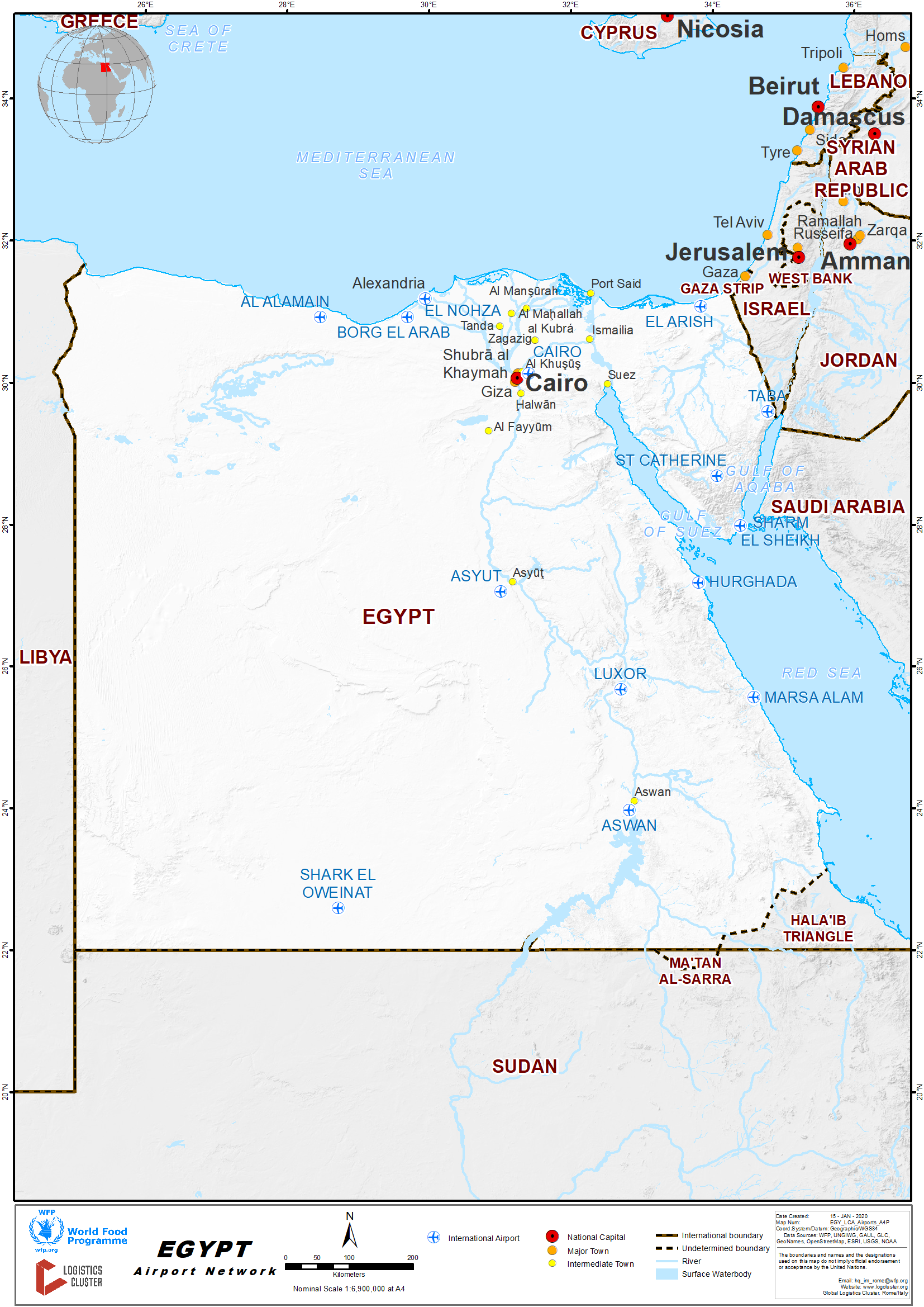
Key airport information may also be found at: http://worldaerodata.com/
For more information on government agency and airport company contact information, please see the following links:
4.1 Egypt Government Contact List
4.5 Egypt Airport Companies Contact List
|
Civil airports |
ICAO |
IATA |
Airport name |
|
6th of October |
HESX |
SPX |
Sphinx International Airport |
|
Abou Redis |
|
AUE |
Abu Rudeis Airport |
|
Abu Simbel |
HEBL |
ABS |
Abu Simbel Airport |
|
Alexandria |
HEAX |
ALY |
Alexandria International Airport |
|
Alexandria / Borg El Arab |
HEBA |
HBE |
Borg El Arab Airport |
|
Almaza |
HEAZ |
|
Almaza Air Base |
|
Assiut |
HEAT |
ATZ |
Assiut Airport |
|
Aswan |
HESN |
ASW |
Aswan International Airport |
|
Cairo |
HECA |
CAI |
Cairo International Airport |
|
Dakhla Oasis |
HEDK |
DAK |
Dakhla Oasis Airport |
|
El Arish |
HEAR |
AAC |
El Arish International Airport |
|
El Dabaa |
HEAL |
DBB |
El Alamain International Airport |
|
El Gouna |
HEGO |
|
El Gouna Airport |
|
El Gora |
HEGR |
EGH |
El Gora Airport |
|
El Kharga |
HEKG |
UVL |
El Kharga Airport |
|
El Tor |
HETR |
ELT |
El Tor Airport |
|
Giza |
HEEM |
|
Embaba Airport (closed) |
|
Hurghada |
HEGN |
HRG |
Hurghada International Airport |
|
Luxor |
HELX |
LXR |
Luxor International Airport |
|
Marsa Alam |
HEMA |
RMF |
Marsa Alam International Airport |
|
Marsa Matrouh |
HEMM |
MUH |
Marsa Matruh Airport |
|
Port Said |
HEPS |
PSD |
Port Said Airport |
|
Ras Shokeir |
|
|
Ras Shokeir New Airport |
|
Sharq El Owainat |
HEOW |
GSQ |
Sharq El Owainat Airport |
|
Sharm El Sheikh |
HESH |
SSH |
Sharm El Sheikh International Airport |
|
Sohag |
HEMK |
HMB |
Sohag International Airport |
|
St. Catherine |
HESC |
SKV |
St. Catherine International Airport |
|
Taba |
HETB |
TCP |
Taba International Airport |
Procedures for Foreign Registered Aircraft
Detailed information on procedures for foreign registered aircraft can be found in the following document:
Egypt Airport Assessment Additional Information
2.2.1 Egypt Cairo International Airport
Airport Overview
Cairo International Airport is located in Heliopolis, 18.3km (11.37 miles) northeast of central Cairo and 40km (24.9 miles) from the Giza Pyramids.
In 1963 Cairo International Airport replaced the old airport located in Heliopolis area with better facilities to have a capacity of 5 million passengers a year.
During the seventies, several halls were constructed adding to the passenger capacity of the airport. In the eighties, a second terminal was built to serve an additional 3.5 million passengers per year.
A development plan is going underway to modernise the facilities and increase the airport passenger capacity to 22 million. Currently Cairo airport consists of 3 terminals built at the highest standards equipped with the latest technological devices to offer its passengers high quality aviation services.
|
Airport Location and Contact |
|
|
Country |
Egypt |
|
Province or District |
Cairo |
|
Nearest Town or City with Distance from Airport |
Cairo, 22 km |
|
Airport’s Complete Name |
Cairo International Airport |
|
Latitude |
30° 7′ 19″ N |
|
Longitude |
31° 24′ 20″ E |
|
Elevation (ft and m) |
382 ft, 116.434m |
|
IATA Code |
CAI |
|
ICAO Code |
HECA |
|
Managing Company or Airport Authority |
Cairo Airport Company |
|
Management Contact Person |
Eng. Ahmad Fawzy abdel Azeem Tel: (202) 22655355 / +20 222 655 000 Fax. :(202) 22680891 |
|
Open From (hours) |
00:00 |
|
Open To (hours) |
00:00 |
Airport Picture
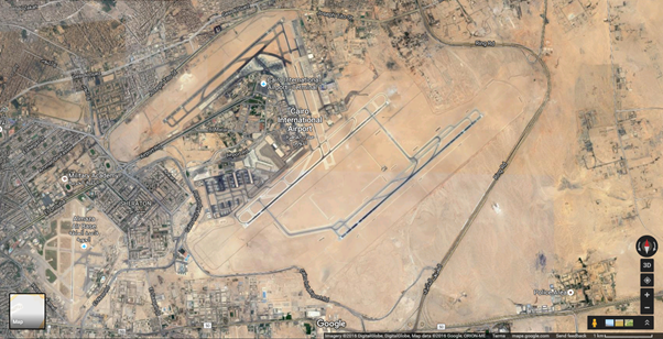
Companies Available
For more information on airport contacts, please see the following link: 4.5 Egypt Airport Companies Contact List
Information on some aviation service providers can be found at: Website of Azfreight on Cairo International Airport
Passenger and Cargo Performance Indicator
|
Performance for 2017 |
|||
|
|
Per Year |
Per Month |
Per Day |
|
Total Aircraft Movements |
19,619 |
|
|
|
Total Passengers |
30,000,000 |
|
|
|
Total Capacity of the Airport (MT) |
120,000 |
|
|
|
Current Activity of the Airport (MT) |
|
|
|
|
Current use by Humanitarian Flights (UNHAS) |
N/A |
|
|
Runways
|
Runway #1 |
|
|
Runway Dimensions |
3,300m x 82m |
|
Orientation |
05C/23R |
|
Surface |
Asphalt |
|
Runway #2 |
|
|
Runway Dimensions |
3,999m x 82m |
|
Orientation |
05C/23C |
|
Surface |
Asphalt |
|
Runway #3 |
|
|
Runway Dimensions |
4,000m x 89m |
|
Orientation |
05R/23L |
|
Surface |
Asphalt |
Helicopter Pad(s)
|
Helipad #1 |
|
|
Present |
Yes |
|
Largest Helicopter that can Land |
No restriction |
|
Width and Length (m) |
No restriction |
|
Surface |
Concrete |
Airport Infrastructure Details
|
Customs |
Yes |
JET A-1 fuel |
Yes |
|
Immigration |
Yes |
AVGAS 100 |
Yes |
|
Terminal Building |
Yes |
Single Point Refuelling |
Yes |
|
Passenger Terminal |
Yes |
Air Starter Units |
Yes |
|
Cargo terminal |
Yes |
Ground Power (mobile) |
Yes |
|
Pax Transport to Airfield |
Yes |
Ground Handling Services |
Yes |
|
Control Tower |
Yes |
Latrine Servicing |
Yes |
|
Weather Facilities |
Yes |
Fire Fighting Category (ICAO) |
Yes |
|
Catering Services |
Yes |
De-icing Equipment |
Yes |
|
Base Operating Room |
Yes |
Parking Ramp Lighting |
Yes |
|
Airport Radar |
Yes |
Approach & Runway Lights |
Yes |
|
NDB |
Yes |
VOR |
Yes |
|
ILS |
Yes |
|
|
Airport Operating Details
|
Operating Details |
|||
|
Maximum Sized Aircraft that can be Offloaded on Bulk Cargo |
No Restrictions |
||
|
Maximum Sized Aircraft that can be Offloaded on Pallet |
No Restrictions |
||
|
Total Aircraft Parking Area (m²) |
n/a |
||
|
Storage Area (m3 and MT) |
n/a |
||
|
Handling Equipment |
|||
|
Elevators / Hi Loaders |
n/a |
Max Capacity (MT) |
n/a |
|
Max Height (m) |
n/a |
||
|
Loading Ramps |
n/a |
||
|
Other Comments |
n/a |
||
Airfield Costs
Information on Handling Charges, Freighter Aircraft, Equipment Charges, Navigational Charges and Aircraft Handling Charges can be found in the following document: Alternative Ground Handling Information
2.2.2 Eypt Hurghada International Airport
Airport Overview
The airport is located inland, 5 km (3 miles) southwest of the downtown of the city of Hurghada (El Dahar district). It serves Hurghada, the centre of Red Sea Governorate of Egypt, seaport city Safaga and a lot of Red Sea beach resorts: Al Quseir, Sharm El Naga, El Gouna, Al-Mahmya, Soma Bay and Makadi Bay.
The route network of Hurghada consists of scheduled passenger services to Cairo and direct connections to several European destinations. More than 40 airlines perform seasonable charter flights to the cities in Western and Eastern Europe, Scandinavia, Russia and the CIS countries. Nowadays the airport has undergone massive renovations to accommodate dramatically rising leisure traffic.
There is only one terminal in the Hurghada airport and car parking is located just outside the terminal. It is possible to get to the city or to the hotels by taxi or public transport (minibuses).
For additional information on services provided in and around Hurghada International Airport please see the following attachment: Egypt Hurghada International Airport Additional Information.docx
|
Airport Location and Contact |
|
|
Country |
Egypt |
|
Province or District |
Hurghada |
|
Nearest Town or City with Distance from Airport |
Hurghada: 5km |
|
Airport’s Complete Name |
Hurghada international airport |
|
Latitude |
27.180381 |
|
Longitude |
33.807683 |
|
Elevation (ft and m) |
16m |
|
IATA Code |
HRG |
|
ICAO Code |
HEGN |
|
Managing Company or Airport Authority |
Ministry of Transport & Aviation |
|
Management Contact Person |
Gnr, Sadik El Showra |
|
Open From (hours) |
24/7 |
|
Open To (hours) |
24/7 |
Airport Picture
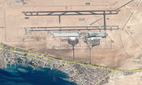
Description and Contacts of Key Companies
Hurghada Airport phone number: +20 65 443 976, fax number: +20 65 443 976.
For more information on airport contacts, please see the following link: 4.5 Egypt Airport Companies Contact List
Information on some aviation service providers can be found at: http://www.azfreight.com/
Passenger and Cargo Performance Indicator
|
Performance for 2017 |
|||
|
|
Per Year |
Per Month |
Per Day |
|
Total Aircraft Movements |
41,595 |
|
|
|
Total Passengers |
7,500,000 |
|
|
|
Total Capacity of the Airport (MT) |
N/A |
|
|
|
Current Activity of the Airport (MT) |
N/A |
|
|
|
Current use by Humanitarian Flights (UNHAS) |
N/A |
|
|
Runways
|
Runway #1 |
|
|
Runway Dimensions |
4,000m x 45m |
|
Orientation |
16/34L |
|
Surface |
Asphalt |
|
Runway #2 |
|
|
Runway Dimensions |
4,000m x 45m |
|
Orientation |
16/34R |
|
Surface |
Asphalt |
Helicopter Pad(s)
|
Helipad #1 |
|
|
Present |
No |
|
Largest Helicopter that can Land |
No |
|
Width and Length (m) |
No |
|
Surface |
No |
Airport Infrastructure Details
|
Customs |
Yes |
JET A-1 fuel |
Yes |
|
Immigration |
Yes |
AVGAS 100 |
No |
|
Terminal Building |
Yes |
Single Point Refuelling |
Yes |
|
Passenger Terminal |
Yes |
Air Starter Units |
Yes |
|
Cargo terminal |
No |
Ground Power (mobile) |
Yes |
|
Pax Transport to Airfield |
Yes |
Ground Handling Services |
Yes |
|
Control Tower |
Yes |
Latrine Servicing |
Yes |
|
Weather Facilities |
Yes |
Fire Fighting Category (ICAO) |
Yes |
|
Catering Services |
Yes |
De-icing Equipment |
Yes |
|
Base Operating Room |
Yes |
Parking Ramp Lighting |
Yes |
|
Airport Radar |
Yes |
Approach & Runway Lights |
Yes |
|
NDB |
Yes |
VOR |
Yes |
|
ILS |
Yes |
|
|
Customs Guidance
For more information on customs in Egypt, please see the following link: 1.3 Egypt Customs Information
Airfield Costs
FUEL SERVICES CHARGES
|
|
Price per Litre USD - $ |
|
Jet A-1 |
0.36 |
|
Avgas |
N/A |
AIR-BRIDGE CHARGES
N/a
2.2.3 Egypt Sharm El-Sheikh International Airport
Airport Overview
|
Location Details |
|||
|
Country |
Egypt |
Latitude |
27°5838N |
|
Province / District |
South Sinai |
Longitude |
34°2341E |
|
Town or City (Closest) |
Sharm El Sheikh |
Elevation (ft and m) |
150 ft |
|
Airfield Name |
Sharm El Sheikh International Airport |
IATA and ICAO Codes |
SSH & HESH |
|
Open From (hours) |
n/a |
Open To (hours) |
n/a |
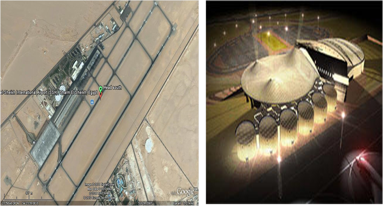
Runways
|
Runway #1 |
|
|
Runway Dimensions |
3,081m x 50m |
|
Orientation |
04L/22R |
|
Surface |
Asphalt |
|
Runway #2 |
|
|
Runway Dimensions |
3,081m x 50m |
|
Orientation |
04R/22L |
|
Surface |
Asphalt |
For more information on airport contacts, please see the following link: 4.5 Egypt Airport Companies Contact List
Information on some aviation service providers can be found at: http://www.azfreight.com/
2.2.4 Egypt Borg El Arab International Airport
Airport Overview
Borg El Arab Airport is an airport serving Alexandria, Egypt. It is located about 40 km (25 mi) southwest of Alexandria, in Borg El Arab . The airport also serves the nearby areas of the Nile Delta. In 2009, the airport served 371,605 passengers (+96.5% vs. 2008). Borg El Arab is the principal airport of Alexandria.
Borg El Arab Airport had a major expansion in terms of the airport's passenger and cargo handling capacity in response to growing demand. The airport consists of a new passenger building and an administration building. The passenger terminal is designed in the shape of a boat and consists of three floors. The ground floor is allocated for checking in and luggage handling.
|
Location Details |
|||
|
Country |
Egypt |
Latitude |
30°5504N |
|
Province / District |
Alexandria Governorate |
Longitude |
29°4147E |
|
Town or City (Closest) |
Alexandria |
Elevation (ft and m) |
177 ft |
|
Airfield Name |
Borg El Arab Airport |
IATA and ICAO Codes |
HBE & HEBA |
|
Open From (hours) |
|
Open To (hours) |
|
Airport Picture
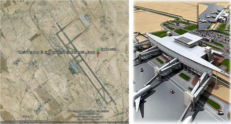
Runways
|
Runway #1 |
|
|
Runway Dimensions |
3,400m x 50m |
|
Orientation |
14/32 |
|
Surface |
Asphalt |
|
Runway #2 |
|
|
Runway Dimensions |
3,400m x 50m |
|
Orientation |
14/33 |
|
Surface |
Asphalt |
For more information on airport contacts, please see the following link: 4.5 Egypt Airport Companies Contact List
2.2.5 Egypt Luxor International Airport
Airport Overview
Luxor International Airport is the main airport serving the city of Luxor, Egypt. It is located four miles (6km) east of the city. Many charter airlines use the airport, as it is a popular tourist destination for those visiting the River Nile and the Valley of the Kings. Facilities for passengers include 48 check-in desks, 8 gates, 5 baggage claim belts, a post office, a bank, a Bureau de Change, an auto exchange machine (CIB), restaurants, cafeterias, a VIP Lounge, a duty free shop, a newsagent/tobacconist, a chemist shop, a gift shop, a travel agent, a tourist help desk, car rental, first aid, a baby/parent Room, disabled access/facilities and a business centre. Facilities for cargo include refrigerated storage, animal quarantine, livestock handling, health officials, X-Ray equipment, and fumigation equipment.
The cargo terminal handling agent for the airport is EgyptAir Cargo. Contacts: Tel: +20 (0)95 237 4655.
|
Location Details |
|||
|
Country |
Egypt |
Latitude |
25°4015N |
|
Province / District |
Luxor Governorate |
Longitude |
32°4223E |
|
Town or City (Closest) |
Luxor |
Elevation (ft and m) |
294 ft |
|
Airfield Name |
Luxor International Airport |
IATA and ICAO Codes |
LXR & HELX |
|
Open From (hours) |
00 |
Open To (hours) |
00 |
Airport Picture

Runways
|
Runway #1 |
|
|---|---|
|
Runway Dimensions |
3,000m x 50m |
|
Orientation |
02/20 |
|
Surface |
Asphalt |
Companies Available
4.5 Egypt Airport Companies Contact List
Information on some aviation service providers can be found at: Website of Azfreight on Luxor International Airport
2.2.6 Egypt Marsa Alam International Airport
Airport Overview
Marsa Alam is an international airport in Egypt and is the first airport in aviation history operating under a complete BOT system. EMAK Marsa Alam for Management & Operation of Airports SAE, a subsidiary of the M.A. Al-Kharafi Group of Kuwait, had successfully negotiated the 40-year BOT concession agreement with the Egyptian Civil Aviation Authority. The new airport is operated under a separate agreement by Aeroports de Paris. The 3,240 meter runway can accommodate Boeing 737 - 757 - 767, Airbus 320 - 310 - 300 jets and similar aircrafts; whilst the taxi-ways permit easy and quick access to the terminal building.
All services and aids necessary for safe operation are incorporated, including rescue services, fully equipped control tower, navigational aids and support facilities. The terminal has a modular design, which can be easily expanded to accommodate up to 4 million passengers a year. All areas, including the secure "check-in" hall, are fully air-conditioned and a number of restaurants, duty-free shops, and other retail outlets are provided for passengers.
| Location Details | |||
|---|---|---|---|
| Country |
Egypt |
Latitude | 25° 33′ 25″ N |
| Province / District | Red Sea Governorate | Longitude | 34° 35′ 1″ E |
| Town or City (Closest) | Marsa Alam town | Elevation (ft and m) | 251 ft. |
| Airfield Name | Marsa Alam International Airport | IATA and ICAO Codes | RMF, HEMA |
Runways
|
Runway #1 |
|
|---|---|
|
Runway Dimensions |
3,200m x 50m |
|
Orientation |
15/33 |
|
Surface |
Asphalt |
Helicopter Pad(s)
Information on helicopter pads can be found in the following document:
Egypt Marsa Alam International Airport Additional Document
Airport Infrastructure Details
Airport facilities:
- Internet Café;
- VIP / Private Aircraft Lounge;
- Police Station;
- First-Aid Clinic;
- Daedalus Lounge;
- Airlines and Tourist Offices;
- Bank and ATM Machines;
- Duty-Free Shop
Airfield Cost
Information on fees and charges can be found in the following document:
Egypt Marsa Alam International Airport Additional Document
Companies Available
4.5 Egypt Airport Companies Contact List
Information on some aviation service providers can be found at:
2.2.7 Egypt Sohag International Airport
Airport Overview
The facility is built to handle approximately 3.5 million passengers per year. The passenger terminal comprises of an international halls for arrivals and departures, a VIP hall, duty-free shops, and security facilities. The airport has its own electricity, water, sewage, and communication stations. There is parking for 400 vehicles and 25 buses.
The airport's single runway is 3 kilometres (1.9 mi) long and 45 metres wide. The airport can receive aircraft as large as the Airbus A320 and Boeing 737. The apron is designed to handle 6 aircraft, with plans to expand this to accommodate 14 aircraft.
The new airport is the fifth international airport in Upper Egypt after Luxor, Aswan, Assiut, and Abu Simbel. The airport primarily caters to domestic travel and traffic between Sohag/Upper Egypt and the Gulf states including Kuwait, Saudi Arabia and the United Arab Emirates.
|
Airport Details |
|||
|
Country |
Egypt |
Latitude |
26°20′25″N |
|
Province / District |
Sohag Governorate |
Longitude |
31°44′20″E |
|
Airport Name |
Sohag Airport |
Elevation (ft) |
859 ft / 262 m |
|
IATA & ICAO codes |
HMB / HESG |
Surface |
Paved |
|
Town or City (closest) |
Sohag |
Runway Condition |
Asphalt |
|
NGO / UN (on ground) |
n/a |
Passenger / Cargo Security Screening (Yes / No) |
Yes |
|
Runway Dimension |
3 km |
Ground Handling (Yes / No) |
Yes |
|
Refueling Capacity |
Yes |
Runway Lighting (Yes / No) |
Yes |
|
Runway Heading |
15/33 |
Fire Fighting Equipment (Yes / No) |
Yes |
|
Air Traffic Control (Yes /No) |
Yes |
Windsock (Yes / No) |
Yes |
|
Weather Information (Yes/ No) |
Yes |
Aircraft Parking space (Yes / No) |
Yes |
|
Navigation Aids (Yes / No) |
Yes |
Perimeter fencing (Yes / No) |
Yes |
Runway
|
Direction |
Length |
Surface |
|
|
m |
ft |
||
|
15/33 |
3,000 |
9,843 |
Asphalt |
2.2.8 Egypt Sphinx International Aiport
Airport Overview
Sphinx International Airport is a public airport, serving the city of Giza, on the western side of Cairo, Egypt. The airport is adjacent to and shares some infrastructure with the Cairo West Air Base.
The single runway is 2 km (1.2 mi) west of the Cairo West runway complex. The aircraft parking ramp and terminal facilities are on the west side of the runway.
|
Airport Details |
|||
|
Country |
Egypt |
Latitude |
30°06′35″N |
|
Province / District |
Giza Governate |
Longitude |
30°53′40″E |
|
Airport Name |
Sphinx Airport |
Elevation (ft) |
553 ft / 169 m |
|
IATA & ICAO codes |
IATA: SPX ICAO: HESX |
Surface |
Paved |
|
Town or City (closest) |
6 of October |
Runway Condition |
Asphalt |
|
NGO / UN (on ground) |
n/a |
Passenger / Cargo Security Screening (Yes / No) |
Yes |
|
Runway Dimension |
2 km (1.2 mi) |
Ground Handling (Yes / No) |
n/a |
|
Refueling Capacity |
n/a |
Runway Lighting (Yes / No) |
Yes |
|
Runway Heading |
n/a |
Fire Fighting Equipment (Yes / No) |
Yes |
|
Air Traffic Control (Yes / No) |
n/a |
Windsock (Yes / No) |
n/a |
|
Weather Information (Yes / No) |
n/a |
Aircraft Parking space (Yes / No) |
n/a |
|
Navigation Aids (Yes / No) |
n/a |
Perimeter fencing (Yes / No) |
n/a |
Runway
|
Direction |
Length |
Surface |
|
|
m |
ft |
||
|
16/34L |
2,000 |
6,561 |
Asphalt |
2.2.9 Egypt Arish International Airport
Airport Overview
|
Airport Details |
|||
|
Country |
Egypt |
Latitude |
31°04′24″N |
|
Province / District |
El Arish Governorate |
Longitude |
31°04′24″N |
|
Airport Name |
El Arish Airport |
Elevation (ft) |
121 ft / 37 m |
|
IATA & ICAO codes |
AAC / HEAR |
Surface |
Paved |
|
Town or City (closest) |
El Arish |
Runway Condition |
Asphalt |
|
NGO / UN (on ground) |
n/a |
Passenger / Cargo Security Screening (Yes / No) |
Yes |
|
Runway Dimension |
3 km |
Ground Handling (Yes / No) |
Yes |
|
Refueling Capacity |
Yes |
Runway Lighting (Yes / No) |
Yes |
|
Runway Heading |
16/34 |
Fire Fighting Equipment (Yes / No) |
Yes |
|
Air Traffic Control (Yes / No) |
Yes |
Windsock (Yes / No) |
Yes |
|
Weather Information (Yes / No) |
Yes |
Aircraft Parking space (Yes / No) |
Yes |
|
Navigation Aids (Yes / No) |
Yes |
Perimeter fencing (Yes / No) |
Yes |
Runway
|
Direction |
Length |
Surface |
|
|
m |
ft |
||
|
16/34 |
3,019 |
9,905 |
Asphalt |
2.2.10 Egypt El Alamein International Airport
Airport Overview
|
Airport Details |
|||
|
Country |
Egypt |
Latitude |
30°55′28″N |
|
Province / District |
El Alamein Governorate |
Longitude |
28°27′41″E |
|
Airport Name |
El Alamein Airport |
Elevation (ft) |
143 ft / 44 m |
|
IATA & ICAO codes |
DBB / HEAL |
Surface |
Paved |
|
Town or City (closest) |
El Alamein |
Runway Condition |
Asphalt |
|
NGO / UN (on ground) |
n/a |
Passenger / Cargo Security Screening (Yes / No) |
Yes |
|
Runway Dimension |
3.5 km |
Ground Handling (Yes / No) |
Yes |
|
Refueling Capacity |
Yes |
Runway Lighting (Yes / No) |
Yes |
|
Runway Heading |
13/31 |
Fire Fighting Equipment (Yes / No) |
Yes |
|
Air Traffic Control (Yes / No) |
Yes |
Windsock (Yes / No) |
Yes |
|
Weather Information (Yes / No) |
Yes |
Aircraft Parking space (Yes / No) |
Yes |
|
Navigation Aids (Yes / No) |
Yes |
Perimeter fencing (Yes / No) |
Yes |
Runway
|
Direction |
Length |
Surface |
|
|
m |
ft |
||
|
13/31 |
3,499 |
11,479 |
Asphalt |
2.2.11 Egypt Taba International Airport
Airport Overview
The airport is located 13 km from Taba and 30 km from Taba Heights, near El Nakb, and adjacent with Eilat, Israel. The airport was named El Nakb Airport. A new terminal building and night lighting was added, and the airport was then renamed Taba International Airport in November 2000.
|
Airport Details |
|||
|
Country |
Egypt |
Latitude |
29°35′16″N |
|
Province / District |
Taba Governorate |
Longitude |
34°46′41″E |
|
Airport Name |
Taba Airport |
Elevation (ft) |
2415 ft / 736 m |
|
IATA & ICAO codes |
TCP / HETB |
Surface |
Paved |
|
Town or City (closest) |
South Sinai |
Runway Condition |
Asphalt |
|
NGO / UN (on ground) |
n/a |
Passenger / Cargo Security Screening (Yes / No) |
Yes |
|
Runway Dimension |
RW1: 4 km RW2: 4 km |
Ground Handling (Yes / No) |
Yes |
|
Refueling Capacity |
Yes |
Runway Lighting (Yes / No) |
Yes |
|
Runway Heading |
RW1: 04L/22R RW2: 04R/22L |
Fire Fighting Equipment (Yes / No) |
Yes |
|
Air Traffic Control (Yes /No) |
Yes |
Windsock (Yes / No) |
Yes |
|
Weather Information (Yes/ No) |
Yes |
Aircraft Parking space (Yes / No) |
Yes |
|
Navigation Aids (Yes / No) |
Yes |
Perimeter fencing (Yes / No) |
Yes |
Runways
|
Direction |
Length |
Surface |
|
|
m |
ft |
||
|
04L/22R |
4,000 |
13,123 |
Asphalt |
|
04L/22L |
4,000 |
13,123 |
Asphalt |
2.2.12 Egypt St. Catherine International Airport
Airport Overview
Saint Catherine city is in the South Sinai Governorate of Egypt. The airport is located about 20 km (12 mi) northeast of the city, which is near Mount Sinai.
|
Airport Details |
|||
|
Country |
Egypt |
Latitude |
28°41′07″N |
|
Province / District |
St.Catherine Governorate |
Longitude |
034°03′45″E |
|
Airport Name |
St. Catherine Airport |
Elevation (ft) |
4368 ft / 1331 m |
|
IATA & ICAO codes |
SKV / HESC |
Surface |
Paved |
|
Town or City (closest) |
South Sinai |
Runway Condition |
Asphalt |
|
NGO / UN (on ground) |
n/a |
Passenger / Cargo Security Screening (Yes / No) |
Yes |
|
Runway Dimension |
2 km |
Ground Handling (Yes / No) |
Yes |
|
Refueling Capacity |
Yes |
Runway Lighting (Yes / No) |
Yes |
|
Runway Heading |
17/35 |
Fire Fighting Equipment (Yes / No) |
Yes |
|
Air Traffic Control (Yes / No) |
Yes |
Windsock (Yes / No) |
Yes |
|
Weather Information (Yes / No) |
Yes |
Aircraft Parking space (Yes / No) |
Yes |
|
Navigation Aids (Yes / No) |
Yes |
Perimeter fencing (Yes / No) |
Yes |
Runways
|
Direction |
Length |
Surface |
|
|
m |
ft |
||
|
17/35 |
2,115 |
6,939 |
Asphalt |
2.2.13 Egypt Abu Simbel Airport
Airport Overview
|
Airport Details |
|||
|
Country |
Egypt |
Latitude |
22°22′33.3″N |
|
Province / District |
Aswan Governate |
Longitude |
31°36′41.9″E |
|
Airport Name |
Abu Simbel Airport |
Elevation (ft) |
616 ft / 188 m |
|
IATA & ICAO codes |
ABS - HEBL |
Surface |
Paved |
|
Town or City (closest) |
Aswan |
Runway Condition |
Asphalt |
|
NGO / UN (on ground) |
n/a |
Passenger / Cargo Security Screening (Yes / No) |
Yes |
|
Runway Dimension |
3 km |
Ground Handling (Yes / No) |
Yes |
|
Refueling Capacity |
Yes |
Runway Lighting (Yes / No) |
Yes |
|
Runway Heading |
15/33 |
Fire Fighting Equipment (Yes / No) |
Yes |
|
Air Traffic Control (Yes / No) |
Yes |
Windsock (Yes / No) |
Yes |
|
Weather Information (Yes / No) |
Yes |
Aircraft Parking space (Yes / No) |
Yes |
|
Navigation Aids (Yes / No) |
Yes |
Perimeter fencing (Yes / No) |
Yes |
Runway
|
Direction |
Length |
Surface |
|
|
m |
ft |
||
|
15/33 |
3,000 |
9,843 |
Asphalt |
2.2.14 Egypt Assiut Airport
Airport Overview
|
Airport Details |
|||
|
Country |
Egypt |
Latitude |
27°02′47″N |
|
Province / District |
Assiut Governate |
Longitude |
31°00′43″E |
|
Airport Name |
Assiut Airport |
Elevation (ft) |
772 ft / 231 m |
|
IATA & ICAO codes |
ATZ / HEAT |
Surface |
Paved |
|
Town or City (closest) |
Assiut |
Runway Condition |
Asphalt |
|
NGO / UN (on ground) |
n/a |
Passenger / Cargo Security Screening (Yes / No) |
Yes |
|
Runway Dimension |
3 km |
Ground Handling (Yes / No) |
Yes |
|
Refueling Capacity |
Yes |
Runway Lighting (Yes / No) |
Yes |
|
Runway Heading |
13/31 |
Fire Fighting Equipment (Yes / No) |
Yes |
|
Air Traffic Control (Yes / No) |
Yes |
Windsock (Yes / No) |
Yes |
|
Weather Information (Yes / No) |
Yes |
Aircraft Parking space (Yes / No) |
Yes |
|
Navigation Aids (Yes / No) |
Yes |
Perimeter fencing (Yes / No) |
Yes |
|
Direction |
Length |
Surface |
|
|
m |
ft |
||
|
13/31 |
3,019 |
9,905 |
Asphalt |
2.2.15 Egypt El Gouna Airport
Airport Overview
|
Airport Details |
|||
|
Country |
Egypt |
Latitude |
27°22′00″N |
|
Province / District |
El Gouna Governorate |
Longitude |
33°40′05″E |
|
Airport Name |
El Gouna Airport |
Elevation (ft) |
56 ft / 17 m |
|
IATA & ICAO codes |
N.A / HEGO |
Surface |
Paved |
|
Town or City (closest) |
Hurghada |
Runway Condition |
Asphalt |
|
NGO / UN (on ground) |
n/a |
Passenger / Cargo Security Screening (Yes / No) |
Yes |
|
Runway Dimension |
1.6 km |
Ground Handling (Yes / No) |
Yes |
|
Refueling Capacity |
Yes |
Runway Lighting (Yes / No) |
Yes |
|
Runway Heading |
16/34 |
Fire Fighting Equipment (Yes / No) |
Yes |
|
Air Traffic Control (Yes / No) |
Yes |
Windsock (Yes / No) |
Yes |
|
Weather Information (Yes / No) |
Yes |
Aircraft Parking space (Yes / No) |
Yes |
|
Navigation Aids (Yes / No) |
Yes |
Perimeter fencing (Yes / No) |
Yes |
|
Direction |
Length |
Surface |
|
|
m |
ft |
||
|
16/34 |
1,605 |
5,265 |
Asphalt |
2.2.16 Egypt Wadi Al Jandali Airport
Airport Overview
|
Airport Details |
|||
|---|---|---|---|
|
Country |
Egypt |
Latitude |
30.049500 | 30 2.969971 N | N30 02 58 |
|
Province / District |
Cairo Governate |
Longitude |
31.839701 | 31 50.382042 E | E031 50 22 |
|
Airport Name |
Wadi Al Jandali Airport |
Elevation (ft) |
816 ft |
|
IATA & ICAO codes |
n/a |
Surface |
Paved |
|
Runway Dimension |
Runway 1: 10,600 x 130 ft / 3,231 x 40 m Runway 2: 11,000 x 130 ft / 3,353 x 40 m |
Ground Handling (Yes / No) |
n/a |
2.2.17 Egypt Aswan Airport
Airport Overview
|
Airport Details |
|||
|
Country |
Egypt |
Latitude |
23°57′51″N |
|
Province / District |
Aswan Governate |
Longitude |
32°49′11″E |
|
Airport Name |
Aswan Airport |
Elevation (ft) |
662 ft /198 m |
|
IATA & ICAO codes |
ASW / HESN |
Surface |
Paved |
|
Town or City (closest) |
Aswan |
Runway Condition |
Asphalt |
|
NGO / UN (on ground) |
n/a |
Passenger / Cargo Security Screening (Yes / No) |
Yes |
|
Runway Dimension |
3.4 km |
Ground Handling (Yes / No) |
Yes |
|
Refueling Capacity |
Yes |
Runway Lighting (Yes / No) |
Yes |
|
Runway Heading |
17/35 |
Fire Fighting Equipment (Yes / No) |
Yes |
|
Air Traffic Control (Yes / No) |
Yes |
Windsock (Yes / No) |
Yes |
|
Weather Information (Yes / No) |
Yes |
Aircraft Parking space (Yes / No) |
Yes |
|
Navigation Aids (Yes / No) |
Yes |
Perimeter fencing (Yes / No) |
Yes |
Runway
|
Direction |
Length |
Surface |
|
|
m |
ft |
||
|
17/35 |
3402 |
11161 |
Asphalt |
2.2.18 Egypt Dakhla Oasis Airport
Airport Overview
|
Airport Details |
|||
|
Country |
Egypt |
Latitude |
25°24′40″N |
|
Province / District |
New Valley Governorate |
Longitude |
29°00′10″E |
|
Airport Name |
Dakhla Airport |
Elevation (ft) |
613ft / 187 m |
|
IATA & ICAO codes |
DAK / HEDK |
Surface |
Paved |
|
Town or City (closest) |
Dakhla Oasis |
Runway Condition |
Asphalt |
|
NGO / UN (on ground) |
n/a |
Passenger / Cargo Security Screening (Yes / No) |
Yes |
|
Runway Dimension |
2.47 km |
Ground Handling (Yes / No) |
Yes |
|
Refueling Capacity |
Yes |
Runway Lighting (Yes / No) |
Yes |
|
Runway Heading |
15/33 |
Fire Fighting Equipment (Yes / No) |
Yes |
|
Air Traffic Control (Yes / No) |
Yes |
Windsock (Yes / No) |
Yes |
|
Weather Information (Yes / No) |
Yes |
Aircraft Parking space (Yes / No) |
Yes |
|
Navigation Aids (Yes / No) |
Yes |
Perimeter fencing (Yes / No) |
Yes |
Runway
|
Direction |
Length |
Surface |
|
|
m |
ft |
||
|
15/33 |
2475 |
8125 |
Paved |
2.3 Egypt Road Network
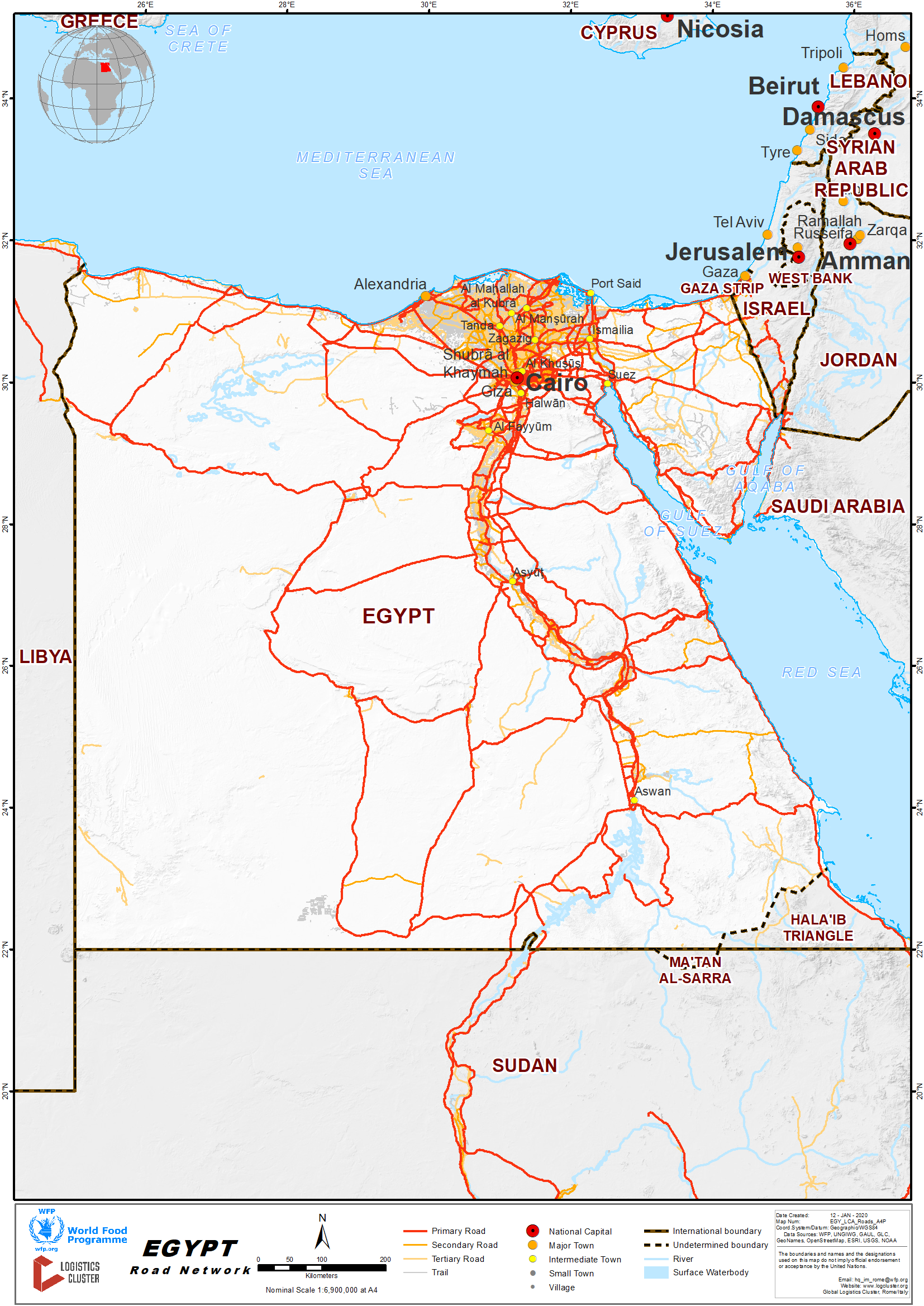
Egypt has a huge road network of 65,050km (of which 48,000km paved and 17,050km unpaved). Egypt has built a network of highways covering the country and extending around 18,000km. Two highways connect Cairo with Alex. Other highways connect Cairo to Port-Said, Suez, and El Fayoum. The total length of highways is 18,000km.
Egypt also boasts a network of bridges, which contributes to smoothing the flow of traffic. So far, 181 bridges stand throughout the country: 36 of which are straddling the Nile; 85 suspended. Egypt has recently witnessed a great interest in enhancing and upgrading the highway and main road networks to cover all the country. Their length increased to 48,000 km.
For more information on government contact details, please see the following link: 4.1 Egypt Government Contact List
Distance Matrix
|
Distances from Capital City to Major Towns (km) |
||||||||||||||||||||
|
|
Alex |
Aswan |
Cairo |
El Fayoum |
El Minya |
Edfu |
Ismailia |
Luxor |
Port Said |
Sharm El Sheikh |
Hurghada |
Nuweiba |
Rafah |
|||||||
|
Alex |
|
1133 |
216 |
295 |
459 |
1,025 |
250 |
915 |
273 |
716 |
761 |
567 |
494 |
|||||||
|
Aswan |
|
|
926 |
838 |
674 |
112 |
1,038 |
229 |
1,118 |
1,492 |
580 |
1373 |
1280 |
|||||||
|
Cairo |
|
|
|
105 |
252 |
818 |
112 |
708 |
192 |
503 |
548 |
447 |
354 |
|||||||
|
El Fayoum |
|
|
|
|
164 |
730 |
217 |
620 |
297 |
608 |
581 |
552 |
459 |
|||||||
|
El Minya |
|
|
|
|
|
565 |
314 |
335 |
444 |
755 |
452 |
693 |
806 |
|||||||
|
Edfu |
|
|
|
|
|
|
930 |
112 |
1,010 |
1,321 |
392 |
1265 |
1172 |
|||||||
|
Ismailia |
|
|
|
|
|
|
|
550 |
80 |
456 |
501 |
387 |
242 |
|||||||
|
Luxor |
|
|
|
|
|
|
|
|
300 |
1212 |
282 |
1155 |
1062 |
|||||||
|
Port Said |
|
|
|
|
|
|
|
|
|
536 |
581 |
467 |
254 |
|||||||
|
Sharm El Sheikh |
|
|
|
|
|
|
|
|
|
|
781 |
165 |
528 |
|||||||
|
Hurghada |
|
|
|
|
|
|
|
|
|
|
|
226 |
464 |
|||||||
|
Nuweiba |
|
|
|
|
|
|
|
|
|
|
|
|
674 |
|||||||
|
Rafah |
|
|
|
|
|
|
|
|
|
|
|
|
|
|||||||
|
Safaga |
|
|
|
|
|
|
|
|
|
|
|
|
|
|||||||
|
Travel Time from Capital City to Major Towns (Hour) |
||||||||||||||||||||
|
|
Alex |
Aswan |
Cairo |
El Fayoum |
El Minya |
Edfu |
Ismailia |
Luxor |
Port Said |
Sharm El Sheikh |
Hurghada |
Nuweiba |
Rafah |
|||||||
|
Alex |
|
14 |
3 |
4 |
6 |
13 |
3 |
11 |
3 |
9 |
10 |
7 |
6 |
|||||||
|
Aswan |
|
|
12 |
10 |
8 |
1 |
13 |
3 |
14 |
18 |
7 |
17 |
16 |
|||||||
|
Cairo |
|
|
|
1 |
3 |
10 |
1 |
9 |
2 |
6 |
7 |
6 |
4 |
|||||||
|
El Fayoum |
|
|
|
|
2 |
9 |
3 |
8 |
4 |
8 |
7 |
7 |
6 |
|||||||
|
El Minya |
|
|
|
|
|
7 |
4 |
4 |
6 |
9 |
6 |
9 |
10 |
|||||||
|
Edfu |
|
|
|
|
|
|
12 |
2 |
13 |
17 |
5 |
16 |
15 |
|||||||
|
Ismailia |
|
|
|
|
|
|
|
7 |
1 |
6 |
6 |
5 |
3 |
|||||||
|
Luxor |
|
|
|
|
|
|
|
|
4 |
15 |
4 |
14 |
13 |
|||||||
|
Port Said |
|
|
|
|
|
|
|
|
|
7 |
7 |
6 |
3 |
|||||||
|
Sharm El Sheikh |
|
|
|
|
|
|
|
|
|
|
10 |
2 |
7 |
|||||||
|
Hurghada |
|
|
|
|
|
|
|
|
|
|
|
3 |
6 |
|||||||
|
Nuweiba |
|
|
|
|
|
|
|
|
|
|
|
|
8 |
|||||||
|
Rafah |
|
|
|
|
|
|
|
|
|
|
|
|
|
|||||||
|
Safaga |
|
|
|
|
|
|
|
|
|
|
|
|
|
|||||||
Road Security
Road accidents are common and police estimate that road accidents kill over 6,000 people in Egypt each year.
International driving licence can be used in Egypt up to six months. In case of intention to stay more than six months in Egypt, an application for an Egyptian driving licence should be submitted.
Weighbridges and Axle Load Limits
|
Axle Load Limits |
LCA Country (Egypt) |
Transit Country #1 (Kingdom of Saudi Arabia ) |
|
Truck with 2 Axles |
16 |
19 |
|
Truck with 3 Axles |
22 |
26 |
|
Truck with 4 Axles |
32 |
39 |
|
Semi-trailer with 3 Axles |
26 |
39 |
|
Semi-trailer with 4 Axles |
32 |
40 |
|
Semi-trailer with 5 Axles |
42 |
N/A |
|
Semi-trailer with 6 Axles |
48 |
N/A |
|
Truck & Drawbar Trailer with 4 Axles |
36 |
N/A |
|
Truck & Drawbar Trailer with 5 Axles |
42 |
N/A |
|
Truck & Drawbar Trailer with 6 Axles |
48 |
N/A |
|
Truck & Drawbar Trailer with 7 Axles |
N/A |
N/A |
2.3.1 Egypt Border Crossing of Rafah
Overview
This land port is located in the North Sinai Governorate on the borders of the Arab Republic of Egypt with the Occupied Palestinian Territory, and considered as the eastern gate of Egypt linking with the East Arab countries and the rest of the countries in both Asia and Europe. Rafah Crossing Point is the sole crossing point between Egypt and the Gaza Strip and between Egypt and the Occupied Palestinian Territory. It is located on the Gaza–Egypt border, which was recognized by the 1979 Israel–Egypt Peace Treaty. The original crossing point was named Rafah land port. Only passage of persons takes place through the Rafah Border Crossing. All traffic of goods is diverted to the Kerem Shalom border crossing.
|
Border Crossing Location and Contact |
|
|---|---|
|
Name of Border Crossing |
Rafah |
|
Province or District |
North Sinai |
|
Nearest Town or City with Distance from Border Crossing |
Rafah - 49 Km |
|
Latitude |
31.2473372 |
|
Longitude |
34.254056 |
|
Managing Authority / Agency |
General Authority for Land and Dry Ports |
|
Travel Times |
|
|---|---|
|
Nearest International Airport |
Name: Arish Airport Distance in km: 50 Truck Travel Time: 1 hr. Car Travel time: 0.5 hrs. |
|
Nearest Port |
Name: Arish Port Distance in km: 50 Truck Travel Time: 1 hr. Car Travel time: 0.5 hrs. |
|
Nearest location with functioning wholesale markets, or with significant manufacturing or production capacity |
Name: Suez Distance in km: 295 Truck Travel Time: 5 hrs. Car Travel time: 3 hrs. |
|
Hours of Operation |
|
|---|---|
|
Mondays |
Irregular – based on needs / humanitarian aid |
|
Tuesdays |
Irregular – based on needs / humanitarian aid |
|
Wednesdays |
Irregular – based on needs / humanitarian aid |
|
Thursdays |
Irregular – based on needs / humanitarian aid |
|
Fridays |
Irregular – based on needs / humanitarian aid |
|
Saturdays |
Irregular – based on needs / humanitarian aid |
|
Sundays |
Irregular – based on needs / humanitarian aid |
|
National Holidays |
Irregular – based on needs / humanitarian aid |
|
Seasonal Constraints |
Winter time / heavy rain |
Port Capacity
Total area: 72,000 m2.
Renewal of the port: the port was developed entirely in 2005, a modern pharonic style was built at a cost of about 46 million pounds.
The port capacity building is sufficient to accommodate with the movement of goods and passengers.
Customs Clearance
For more information on customs in Egypt, please see the following link:
Other Relevant Information
For more information on government contact details, please see the following link:
2.3.2 Egypt Land Border Crossing of El Oga
Overview
This land port was established in 1982 on an area of 45,000 m2 and was under the administration of the province of North Sinai. Since it has been attached to the General Authority of Land and Dry Ports in 1996, it has been developed and expanded in different phases to increase its capacity building and the number of trucks crossing. The port is dedicated for the movement of goods only, with the ability to be used in the future for the movement of people. Nitsana Cross is on the other side.
|
Border Crossing Location and Contact |
|
|
Name of Border Crossing
|
Oga |
|
Province or District |
North Sinai |
|
Nearest Town or City with Distance from Border Crossing |
Town Name: Arish Distance in km: 82 |
|
Latitude |
30.882861 |
|
Longitude |
34.391208 |
|
Managing Authority / Agency |
General Authority for Land and Dry Ports |
|
Contact Person |
|
|
Travel Times |
|
|
Nearest International Airport |
Name: Al Arish Distance in km: 70 Truck Travel Time: hrs 1.30 Car Travel time: 45 mins |
|
Nearest Port |
Name: Arish Distance in km: 80 Truck Travel Time: hrs 1.45 Car Travel time: hrs 1 |
|
Nearest location with functioning wholesale markets, or with significant manufacturing or production capacity |
Name: Suez Distance in km: 280 Truck Travel Time: hrs 5 Car Travel time: hrs 3 |
|
Other Information |
N/A |
|
Hours of Operation |
|
|
Mondays |
Irregular |
|
Tuesdays |
Irregular |
|
Wednesdays |
Irregular |
|
Thursdays |
Irregular |
|
Fridays |
Irregular |
|
Saturdays |
Irregular |
|
Sundays |
Irregular |
|
National Holidays |
Irregular |
|
Seasonal Constraints |
Heavy rain - Few days in winter |
Daily Capacity
N/A
Customs Clearance
For more information on customs in Egypt, please see the following link: 1.3 Egypt Customs Information
Other Relevant Information
For more information on government contact details, please see the following link: 4.1 Egypt Government Contact List
2.3.3 Egypt Land Border Crossing of Taba
Overview
The port is located in the area of Taba in the South Sinai Governorate, on the Gulf of Aqaba, 8km from the northern head of the Gulf. It is bordered to the north gate with Israel and south with Taba city, bordered to the east of Aqaba Bay Beach and Hilton Taba, and bounded on the west with the hills overlooking the Taba land port.
|
Border Crossing Location and Contact |
|
|
Name of Border Crossing
|
Taba |
|
Province or District |
South Sinai |
|
Nearest Town or City with Distance from Border Crossing |
Town Name: Nuweibaa Distance in km: 74 |
|
Latitude |
29.492085 |
|
Longitude |
34.900753 |
|
Managing Authority / Agency |
General Authority for Land and Dry Ports |
|
Contact Person |
|
|
Travel Times |
|
|
Nearest International Airport |
Name: Taba International Airport Distance in km: 37 Truck Travel Time: hrs 1 Car Travel time: 30 mins |
|
Nearest Port |
Name: Nuaibaa Sea Port Distance in km : 84 Truck Travel Time: hrs 1.45 Car Travel time: hrs 1 |
|
Nearest location with functioning wholesale markets, or with significant manufacturing or production capacity |
Name: Suez Distance in km: 300 Truck Travel Time: hrs 5 Car Travel time: hrs 3 |
|
Other Information |
N/A |
|
Hours of Operation |
|
|
Mondays |
24/7 |
|
Tuesdays |
24/7 |
|
Wednesdays |
24/7 |
|
Thursdays |
24/7 |
|
Fridays |
24/7 |
|
Saturdays |
24/7 |
|
Sundays |
24/7 |
|
National Holidays |
24/7 |
|
Seasonal Constraints |
Heavy rain - Few days in winter |
Daily Capacity
Due to its geographic location, the Terminal's area is limited to a narrow strip, 45m wide and 200m long. Approximately one million passengers and 70,000 vehicles pass through every year.
Customs Clearance
For more information on customs in Egypt, please see the following link: 1.3 Egypt Customs Information
Other Relevant Information
For more information on government contact details, please see the following link: 4.1 Egypt Government Contact List
2.3.4 Egypt Land Border Crossing of Qustul
Overview
The port is 45 km of Qstol-Halfa. It allows the cargo trucks to transport freight to the importing country and returning loaded with goods to the other end, as to increase the benefit of the fleet between both countries according to the cooperation protocol signed by Egypt and Sudan. The port's total area is 60,000 m2.
|
Border Crossing Location and Contact |
|
|
Name of Border Crossing
|
Egypt: Qustul |
|
Province or District |
Red Sea |
|
Nearest Town or City with Distance from Border Crossing |
Town Name: Aswan Distance in km: 400 |
|
Latitude |
22.003058 |
|
Longitude |
31.513452 |
|
Managing Authority / Agency |
General Authority for Land and Dry Ports |
|
Contact Person |
|
|
Travel Times |
|
|
Nearest International Airport |
Name: Aswan International Airport Distance in km: 406 Truck Travel Time: hrs 6 Car Travel time: hrs 4 |
|
Nearest Port |
Name : NA Distance in km: NA Truck Travel Time: hrs 1.45 Car Travel time: hrs 1 |
|
Nearest location with functioning wholesale markets, or with significant manufacturing or production capacity |
Name : Aswan Distance in km : 400 Truck Travel Time: hrs 6 Car Travel time: hrs 4 |
|
Other Information |
N/A |
|
Hours of Operation |
|
|
Mondays |
9 am to 3pm in winter, and from 9 am to 4pm at summer according to the working hours of Nasser Lake that operates during the day light only. |
|
Tuesdays |
9 am to 3pm in winter, and from 9 am to 4pm at summer according to the working hours of Nasser Lake that operates during the day light only. |
|
Wednesdays |
9 am to 3pm in winter, and from 9 am to 4pm at summer according to the working hours of Nasser Lake that operates during the day light only. |
|
Thursdays |
9 am to 3pm in winter, and from 9 am to 4pm at summer according to the working hours of Nasser Lake that operates during the day light only. |
|
Fridays |
9 am to 3pm in winter, and from 9 am to 4pm at summer according to the working hours of Nasser Lake that operates during the day light only. |
|
Saturdays |
9 am to 3pm in winter, and from 9 am to 4pm at summer according to the working hours of Nasser Lake that operates during the day light only. |
|
Sundays |
9 am to 3pm in winter, and from 9 am to 4pm at summer according to the working hours of Nasser Lake that operates during the day light only. |
|
National Holidays |
9 am to 3pm in winter, and from 9 am to 4pm at summer according to the working hours of Nasser Lake that operates during the day light only. |
|
Seasonal Constraints |
Heavy rain - Few days in winter |
Daily Capacity
NA
Customs Clearance
For more information on customs in Egypt, please see the following link: 1.3 Egypt Customs Information
Other Relevant Information
For more information on government contact details, please see the following link: 4.1 Egypt Government Contact List
2.3.5 Egypt Land Border Crossing of El Salloum
Overview
El Salloum is a village on the northern coast of Egypt, near the Mediterranean Sea, east of the border with Libya, and around 145 km (90 mi) from Tobruk. El Salloum is a regional trading centre.
|
Border Crossing Location and Contact |
|
|
Name of Border Crossing
|
Egypt: El
Salloum |
|
Province or District |
Matrouh |
|
Nearest Town or City with Distance from Border Crossing |
Town Name: Matrouh Distance in km: 300 |
|
Latitude |
22.003058 |
|
Longitude |
31.513452 |
|
Managing Authority / Agency |
General Authority for Land and Dry Ports |
|
Contact Person |
|
|
Travel Times |
|
|
Nearest International Airport |
Name: Matrouh airport Distance in km: 300 Truck Travel Time: hrs 6 Car Travel time: hrs 4 |
|
Nearest Port |
Name: N/a Distance in km: N/a Truck Travel Time: hrs 1.45 Car Travel time: hrs 1 |
|
Nearest location with functioning wholesale markets, or with significant manufacturing or production capacity |
Name: Matrouh Distance in km: 300 Truck Travel Time: hrs 6 Car Travel time: hrs 4 |
|
Other Information |
N/a |
|
Hours of Operation |
|
|
Mondays |
Working till 15:00 PM |
|
Tuesdays |
Working till 15:00 PM |
|
Wednesdays |
Working till 15:00 PM |
|
Thursdays |
Working till 15:00 PM |
|
Fridays |
Day off |
|
Saturdays |
Day off |
|
Sundays |
Working till 15:00 PM |
|
National Holidays |
Working till 15:00 PM |
|
Seasonal Constraints |
Heavy rain in winter |
Daily Capacity
N/A
Customs Clearance
For more information on customs in Egypt, please see the following link: 1.3 Egypt Customs Information
Other Relevant Information
For more information on government contact details, please see the following link: 4.1 Egypt Government Contact List
2.4 Egypt Railway Assessment
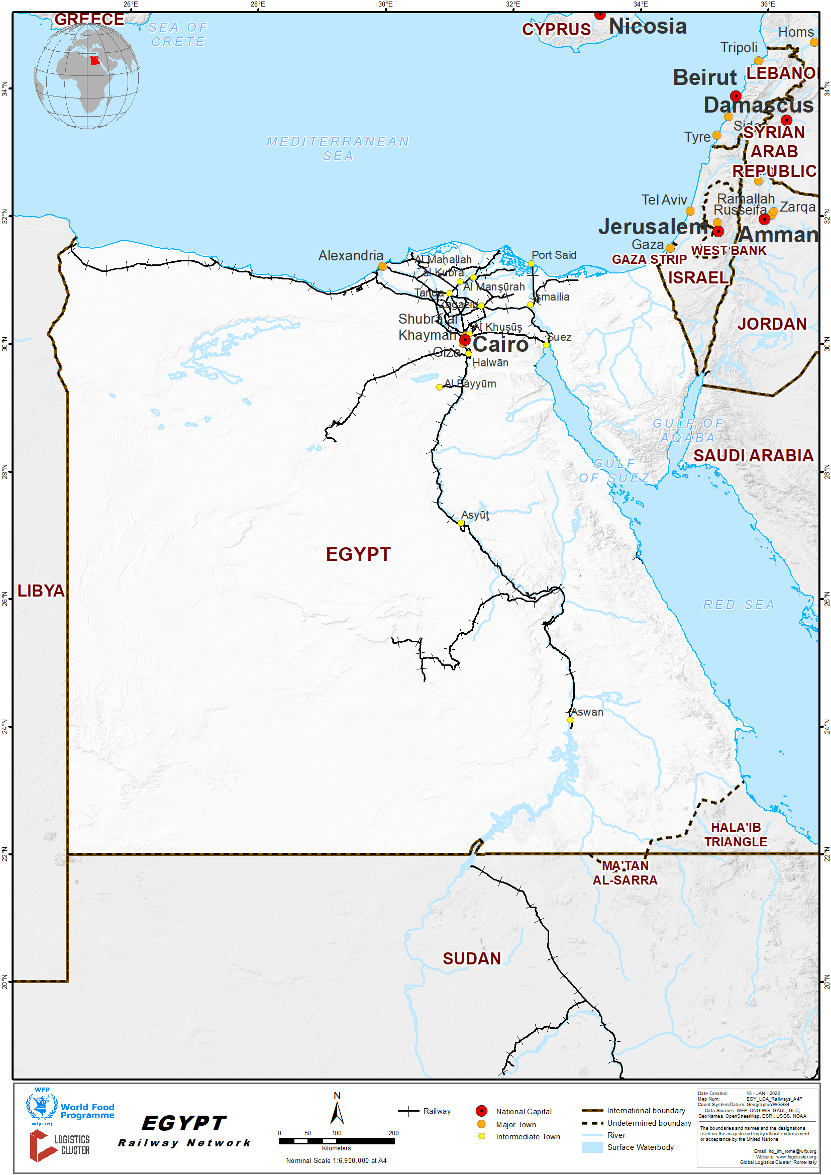
Egyptian National Railway is one of the largest economic institutions in Egypt and the Arab world, and is the oldest in the area of transport services (passengers and goods). It's considered the backbone of passenger transport in Egypt, where the volume of railway passengers and goods transport is:
- Passengers transport: 500 million passengers annually (about 1.4 million passengers a day).
- Goods transport: 6 million tons annually.
The total length of network is 9570 km.
- Paths of quadripartite lines - 20 km
- Paths of double lines - 1466 km
- Paths of single line - 3667 km
Railway's yards, workshops and warehouses
Signals system on the heavy lines of movement to achieve the safety factors on them
- Lines working by electrical signals 15%
- Lines working by mechanical signal 85%
The total number of stations is 705 major, sub and medium-stations, including:
- Main stations - 22
- Central stations - 59
- Medium stations - 60
- Small stations - 564
Number of Bridges and Tunnels - 885
- Railway bridges on the Nile and waterways, 511
- Bridges above the Railway for cars, 58
- Tunnels for cars and pedestrians, 137
- Bridges overhead for pedestrians, 137
- 342 German locomotive, capacity 2475 hp
- 45 Canadian locomotive, capacity 2475 hp
- 30 U.S. locomotive, capacity 1850 hp
- 253 Canadian locomotive, capacity 1650 hp
- 30 locomotive maneuver Spanish, capacity 1200 hp
- 80 new U.S. locomotive GE, capacity 4000 HP
- 40 new U.S. locomotive EMD, capacity 3245 hp
The fleet of passenger transport coaches is 3500 including 850 air-conditioned coaches the passenger transport service on the ENR of different qualities, ranging in speed from 90 to 120 km/h Fast sleep trains, and first and second AC luxury Special trains Renovated trains Suburban trains, with average speed of 90 km/h.
The Egyptian Ministry of Transportation (MOT) has recently modified the railway law allowing private sector participation and operation of railway projects. There is significant local demand for railway parts in the Egyptian market.
For information please select the following document: Egypt Railway Assessment Additional Information.docx
For more information on government contact details, please see the following link: 4.1 Egypt Government Contact List
Travel Time Matrix
| Unit of measurement - km | |||||||||||||
|
|
Alex |
Aswan |
Cairo |
El |
El |
Edfu |
Ismailia |
Luxor |
Port |
Sharm |
Hurghada |
Nuweiba |
Rafah |
|
Fayoum |
Minya |
Said |
El |
||||||||||
|
|
|
|
Sheikh |
||||||||||
|
Alex |
|
1133 |
216 |
295 |
459 |
1,025 |
250 |
915 |
273 |
716 |
761 |
567 |
494 |
|
Aswan |
|
|
926 |
838 |
674 |
112 |
1,038 |
229 |
1,118 |
1,492 |
580 |
1373 |
1280 |
|
Cairo |
|
|
|
105 |
252 |
818 |
112 |
708 |
192 |
503 |
548 |
447 |
354 |
|
El |
|
|
|
|
164 |
730 |
217 |
620 |
297 |
608 |
581 |
552 |
459 |
|
Fayoum |
|||||||||||||
|
El Minya |
|
|
|
|
|
565 |
314 |
335 |
444 |
755 |
452 |
693 |
806 |
|
Edfu |
|
|
|
|
|
|
930 |
112 |
1,010 |
1,321 |
392 |
1265 |
1172 |
|
Ismailia |
|
|
|
|
|
|
|
550 |
80 |
456 |
501 |
387 |
242 |
|
Luxor |
|
|
|
|
|
|
|
|
300 |
1212 |
282 |
1155 |
1062 |
|
Port Said |
|
|
|
|
|
|
|
|
|
536 |
581 |
467 |
254 |
|
Sharm El |
|
|
|
|
|
|
|
|
|
|
781 |
165 |
528 |
|
Sheikh |
|||||||||||||
|
Hurghada |
|
|
|
|
|
|
|
|
|
|
|
226 |
464 |
|
Nuweiba |
|
|
|
|
|
|
|
|
|
|
|
|
674 |
| Unit of measurement - hours | |||||||||||||
|
|
Alex |
Aswan |
Cairo |
El |
El |
Edfu |
Ismailia |
Luxor |
Port |
Sharm |
Hurghada |
Nuweiba |
Rafah |
|
Fayoum |
Minya |
Said |
El |
||||||||||
|
|
|
|
Sheikh |
||||||||||
|
Alex |
|
14 |
3 |
4 |
6 |
13 |
3 |
11 |
3 |
9 |
10 |
7 |
6 |
|
|
|||||||||||||
|
Aswan |
|
|
12 |
10 |
8 |
1 |
13 |
3 |
14 |
18 |
7 |
17 |
16 |
|
|
|||||||||||||
|
Cairo |
|
|
|
1 |
3 |
10 |
1 |
9 |
2 |
6 |
7 |
6 |
4 |
|
|
|||||||||||||
|
El |
|
|
|
|
2 |
9 |
3 |
8 |
4 |
8 |
7 |
7 |
6 |
|
Fayoum |
|||||||||||||
|
El Minya |
|
|
|
|
|
7 |
4 |
4 |
6 |
9 |
6 |
9 |
10 |
|
|
|||||||||||||
|
Edfu |
|
|
|
|
|
|
12 |
2 |
13 |
17 |
5 |
16 |
15 |
|
|
|||||||||||||
|
Ismailia |
|
|
|
|
|
|
|
7 |
1 |
6 |
6 |
5 |
3 |
|
|
|||||||||||||
|
Luxor |
|
|
|
|
|
|
|
|
4 |
15 |
4 |
14 |
13 |
|
Port Said |
|
|
|
|
|
|
|
|
|
7 |
7 |
6 |
3 |
|
Sharm El |
|
|
|
|
|
|
|
|
|
|
10 |
2 |
7 |
|
Sheikh |
|||||||||||||
|
Hurghada |
|
|
|
|
|
|
|
|
|
|
|
3 |
6 |
|
Nuweiba |
|
|
|
|
|
|
|
|
|
|
|
|
8 |
|
Rafah |
|
|
|
|
|
|
|
|
|
|
|
|
|
|
Safaga |
|
|
|
|
|
|
|
|
|
|
|
|
|
Railway Companies and Consortia
The railway industry is operated by the government through the Ministry of Transport.
Key Route Information
- The total length of network is 9570 km
- Paths of quadripartite lines 20 km
- Paths of double lines 1466 km
- Paths of single line 3667 km
- Railway's yards, workshops and warehouses
Key Stations
|
Key Station Information |
|||
|
|
Station Name |
Station Name |
Station Name |
|
Location |
Cairo |
Giza |
Alexandria |
|
Contact Information |
117 +2022573555 |
+20235717318 |
+2033922883 |
|
Connections with Other Transport Means |
Road |
Road |
Road |
|
Storage Capacity |
N/A |
N/A |
N/A |
|
Handling Equipment |
N/A |
N/A |
N/A |
|
Handling Capacity |
N/A |
N/A |
N/A |
|
Other Comments |
N/A |
N/A |
N/A |
2.5 Egypt Waterways Assessment
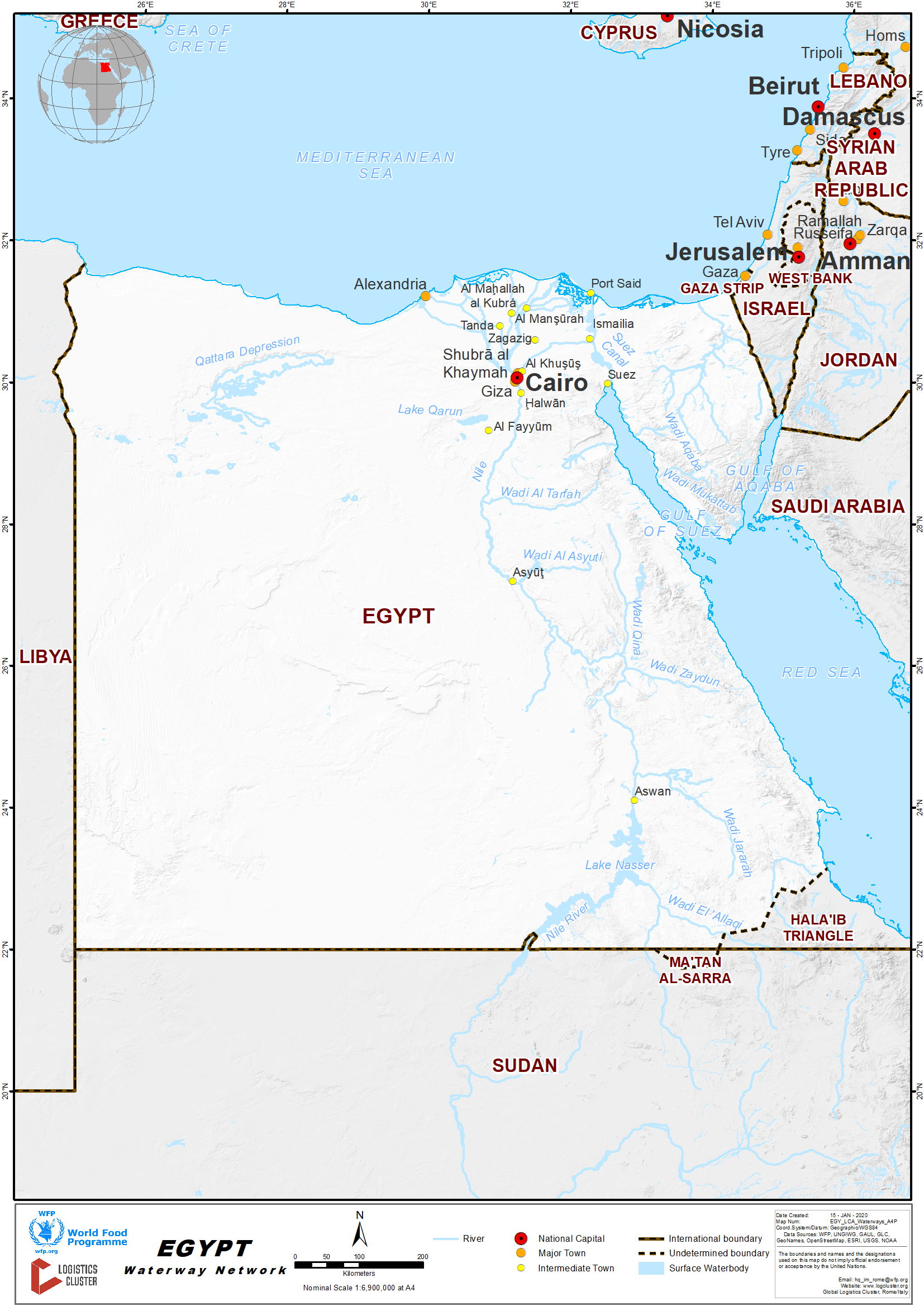
The main waterway is the Nile River part crossing Egypt with total length estimated 3,500km. This length includes Nile River, Lake Nasser, Alexandria-Cairo Waterway, and numerous smaller canals in delta; Suez Canal (193.5 km including approaches) navigable by oceangoing vessels drawing up to 17.68 m.
The Nile River is passable by barges, passengers cruises in some parts of areas within Egypt. Those areas are mainly Abu Sambel – Aswan Luxor. In addition to some northern parts especially Asyout – Minya- Cairo
For more information on government contact details, please see the following link: 4.1 Egypt Government Contact List
2.6 Egypt Storage Assessment
Commercial Storage
|
Location |
Owner |
Available for Rent |
Capacity (MT / m² / m³) |
Type [1] |
Access [2] |
Condition [3] |
|
6 of October City |
Agility |
Yes |
154, 000 m2 |
Open/covered |
Flat |
Intact |
|
6 of October City |
6 of October for storage and distribution |
Yes |
243,600 m2 |
Concrete |
Flat |
Intact |
|
6 of October City |
Sosdi Dry Port |
Yes |
15000 m2 |
Concrete |
Flat |
Intact |
[1] Warehouse Type: Open storage, container, rub-hall, silo, concrete, other, unspecified
[2] Warehouse Access: Raised-siding, flat
[3] Warehouse condition: Appears intact, appears damaged, under construction/repair
2.7 Egypt Milling Assessment
Egypt has over 130 mills of which almost all of them are using fortification technology.
Milling Company - Banha Cylinders Mill
|
Company Name & Address |
Contact Names & Email |
Telephone & Fax |
|
Banha Cylinders Mill Middle&West Mill Comp |
Name: Eng Sobhy Abdelsatar Ali Title: General Manager |
Tel: +201 2425 6670 Fax: +201 3322 5319 |
|
Summary of Role and Services: Public sector company managed and partially owned by the Food Industry Holding Company, a Government Company belong to the Ministry of Investment. |
||
| Facilities | |
| Parking area inside compound m² |
500 m² |
|
Drainage |
Good |
|
Fire Fighting Equipment (Yes / No) |
Yes |
|
Number of Ventilators (screened) |
Sufficient number |
|
Electricity Load (KVA) |
1200 |
|
Backup Generator (Yes / No / KVA) |
No |
|
Milling Equipment |
|||
|
Origin of Machinery |
Year of Mfg |
Year of Installation |
Condition |
|
MMW Germany |
1970 |
1971, renovated in 1990 |
Good |
|
Maintenance |
|||
|
Duration |
Twice a month |
Type of Maintenance |
NA |
|
Other Equipment or Machinery Installed |
||||
|
Type of Equipment |
Available |
Number |
Owned |
Comments |
|
Fortification Feeder |
Yes |
2 |
n/a |
n/a |
|
Bag Cleaning Plant |
No |
- |
- |
- |
|
Moisture Tester |
No |
- |
- |
- |
|
De-stoning Plant |
Yes |
3 |
n/a |
n/a |
|
Metal Extractor |
Yes |
6 |
n/a |
n/a |
|
Staffing |
|
|
Number of Full Time Skilled Workers |
8 |
|
Number of Full Time Labourers |
120 |
|
Weighbridge |
||||
|
Number |
n/a |
Capacity (MT) |
Length (m) |
Type |
|
Within Compound |
100 |
15 |
Pescol |
|
|
Building |
|||
|
|
Length (m) |
Width (m) |
Height (m) |
|
Building – Wheat Mill |
80 |
19 |
24 |
|
Building – Maize Mill |
n/a |
n/a |
n/a |
|
Walls |
|
n/a |
|
|
Roof |
|
n/a |
|
|
Floor |
|
n/a |
|
|
Conditions & Cleanliness |
||
|
|
Outside |
Inside |
|
Cracks in walls or roof |
No |
No |
|
Signs of rodent activity |
No |
No |
|
Signs of birds entry (Yes / No) |
No |
No |
|
Damaged gutters/drains (Yes / No) |
No |
No |
|
Signs of moisture (Yes / No) |
No |
No |
|
Adjacent Vegetation (Yes / No) |
No |
No |
|
Cleanliness (Good / Poor) |
Good |
Good |
|
Pest Control |
|||
|
Fumigation |
Yes |
Frequency |
Every Year |
|
Spraying |
Yes |
Frequency |
Every three months |
|
Rodenticides |
No |
Frequency |
- |
|
Rodent Trapping |
Yes |
Frequency |
Permanently |
|
Security |
|
|
Security |
Good |
|
Compound (Fenced / Not Fenced) |
Fenced |
|
Other Comments |
n/a |
|
Access |
|||
|
Distance from main town (km) |
Within town |
||
|
Travel time if not located in town (hours) |
n/a |
||
|
Road condition to Mill |
Asphalted |
||
|
Road limitation (if any) |
Maximum width: 15; maximum tonnage: 50 mt |
||
|
Rail connections (Yes / No) |
Yes |
||
|
On the railway from |
Rail is connected directly to mill premises |
to |
Rail is connected directly to mill premises |
|
Commodities |
Daily Capacity (mt) |
Monthly Activity (mt) |
|
Wheat |
400 |
12,000 |
|
Maize |
n/a |
70 mt is milled for 4-6 months period |
|
Storage Capacity |
||
|
Storage in Metric Tonnes |
Wheat – Covered (mt) |
Flour – Covered (mt) |
|
Within the Compound |
5,000 |
750 |
|
Outside the Compound |
20,000 |
n/a |
|
Capacity to Blend |
|
Maize flour is blended to wheat flour 10% : 90% --- 40 mt : 400 mt |
Milling Company - Middle and West Delta Mill Company
|
Company Name & Address |
Contact Names & Email |
Telephone & Fax |
|
Middle & West Delta Mill Comp |
Name: Eng Mohamed Abd El Ghaffar Title: Production Manager |
Tel: +204 1927 0419 Tel2: +204 7257 7330 Fax: +204 7256 2058 |
|
Summary of Role and Services: Public sector company managed, and partially owned by the Food Industry Holding Company, a Government Company belong to the Ministry of Investment. |
||
|
Facilities |
||
|
Parking area inside compound m² |
12,000 m² |
|
|
Drainage |
Good |
|
|
Fire Fighting Equipment (Yes / No) |
Yes |
|
|
Number of Ventilators |
60 |
Screened |
|
Electricity Load (KVA) |
320 |
|
|
Backup Generator |
No |
KVA |
|
Staffing |
|
|
Number of full time skilled workers |
20 |
|
Number of full time labourers |
140 |
|
Weighbridge |
||||
|
Number |
n/a |
Capacity (mt) |
Length (m) |
Type |
|
Within Compound |
100 |
15 |
Pescol |
|
|
Security |
|
|
Security (Good / Poor) |
Good |
|
Compound (Fenced / Not Fenced) |
Fenced |
|
Other Comments |
n/a |
|
Building |
|||
|
|
Length (m) |
Width (m) |
Height (m) |
|
Building – Wheat Mill |
160 |
50 |
15 |
|
Building – Maize Mill |
n/a |
n/a |
n/a |
|
Walls |
|
n/a |
|
|
Roof |
|
n/a |
|
|
Floor |
|
n/a |
|
|
Conditions & Cleanliness |
||
|
|
Outside |
Inside |
|
Cracks in walls or roof (Yes / No) |
No |
No |
|
Signs of rodent activity (Yes / No) |
No |
No |
|
Signs of birds entry (Yes / No) |
Yes |
No |
|
Damaged gutters/drains (Yes / No) |
No |
No |
|
Signs of moisture (Yes / No) |
No |
No |
|
Adjacent Vegetation (Yes / No) |
Yes, Uncut |
n/a |
|
Pest Control |
|||||
|
Fumigation |
Yes |
Frequency |
Once a year |
Contracted (Yes / No) |
n/a |
|
Spraying |
No |
Frequency |
- |
Contracted (Yes / No) |
- |
|
Rodenticides |
Yes |
Frequency |
When required |
Contracted (Yes / No) |
n/a |
|
Rodent Trapping |
Yes |
Frequency |
When required |
Contracted (Yes / No) |
n/a |
| Access | |||
|---|---|---|---|
| Distance from main town (km) | 1 km | ||
| Travel time if not located in town (hours) | 10 minutes | ||
|
Road condition to Mill |
n/a |
||
|
Road limitation (if any) |
Max width: 6; Max tonnage: 60 mt |
||
|
Rail connections (Yes / No) |
No |
||
|
On the railway from |
- |
to |
- |
|
Milling Capacity (Mt) |
||
|
Commodities |
Daily Capacity (mt) |
Monthly Activity (mt) |
|
Wheat |
400 |
12,000 |
|
Maize |
50 |
1,500 |
|
Storage Capacity |
||
|
Storage in Metric Tonnes |
Wheat – Covered (mt) |
Flour – Covered (mt) |
|
Within the Compound |
5,000 |
360 |
|
Capacity to Blend |
|
400 mt can be blended to 50 mt maize per day |
|
Loading & Discharge Rates |
|
360 mt /day |
|
Transport Capacity at Mill |
|
Fleet owned by mill company |
Milling Company - Upper Egypt Mill Company
|
Company Name & Address |
Contact Names & Email |
Telephone & Fax |
|
Upper Egypt Mill Company |
Name: Eng Ashraf Morsy |
Tel: +201 2703 2224 Fax: +209 3480 0775 |
|
Summary of Role and Services: Public sector company managed, and partially owned by the Food Industry Holding Company, a Government Company belong to the Ministry of Investment. |
||
|
Facilities |
||
|
Parking area inside compound m² |
No |
|
|
Drainage |
Good |
|
|
Fire Fighting Equipment (Yes / No) |
Yes |
|
|
Number of Ventilators |
40 |
Screened |
|
Electricity Load (KVA) |
320 |
|
|
Backup Generator (Yes / No / KVA) |
No | |
|
Milling Equipment |
|||
|
Origin of Machinery |
Year of Mfg |
Year of Installation |
Condition |
|
Turkey |
2001 |
2002 |
Good |
|
Maintenance |
|||
|
Duration (hours / week) |
8 hours / week |
Type of maintenance |
Preventative |
|
Other Equipment or Machinery Installed |
||||
|
Type of Equipment |
Yes/No |
Number |
Owned |
Comments |
|
Fortification Feeder |
Yes |
2 |
Yes |
n/a |
|
Bag Cleaning Plant |
Yes |
1 |
Yes |
n/a |
|
Moisture Tester |
No |
- |
- |
- |
|
De-stoning Plant |
Yes |
10 |
Yes |
n/a |
|
Metal Extractor |
Yes |
3 |
Yes |
n/a |
|
Staffing |
|
|
Number of full time skilled workers |
50 |
|
Number of full time labourers |
120 |
|
Building |
|||
|
|
Length (m) |
Width (m) |
Height (m) |
|
Building – Wheat Mill |
40 |
25 |
15 |
|
Building – Maize Mill |
n/a |
n/a |
n/a |
|
Walls |
|
n/a |
|
|
Roof |
|
n/a |
|
|
Floor |
|
n/a |
|
|
Conditions & Cleanliness |
||
|
|
Outside |
Inside |
|
Cracks in walls or roof (Yes / No) |
No |
No |
|
Signs of rodent activity (Yes / No) |
No |
No |
|
Signs of birds entry (Yes / No) |
No |
No |
|
Damaged gutters/drains (Yes / No) |
No |
No |
|
Signs of moisture (Yes / No) |
No |
No |
|
Adjacent Vegetation (Yes / No) |
n/a |
n/a |
|
Cleanliness (Good / Poor) |
n/a |
n/a |
|
Pest Control |
|||||
|
Fumigation |
Yes |
Frequency |
Every 3 months |
Contracted (Yes / No) |
n/a |
|
Spraying |
No |
Frequency |
- |
Contracted (Yes / No) |
- |
|
Rodenticides |
Yes |
Frequency |
Whenrequired |
Contracted (Yes / No) |
- |
|
Rodent Trapping |
No |
Frequency |
- |
Contracted (Yes / No) |
- |
|
Security |
|
|
Security (Good / Poor) |
Good |
|
Compound (Fenced / Not Fenced) |
Fenced |
|
Other Comments |
n/a |
|
Access |
|||
|
Distance from main town (km) |
1 km |
||
|
Travel time if not located in town (hours) |
5 minutes |
||
|
Road condition to Mill |
Asphalted |
||
|
Road limitation (if any) |
Max width: 12; Max tonnage: 60 |
||
|
Rail connections (Yes / No) |
No |
||
|
On the railway from |
- |
to |
- |
|
Milling Capacity (Mt) |
||
|
Commodities |
Daily Capacity (mt) |
Monthly Activity (mt) |
|
Wheat |
450 |
13,500 |
|
Maize |
50 |
1,500 |
|
|
Storage Capacity |
|
|
Storage in Metric Tonnes |
Wheat – Covered (mt) |
Flour – Covered (mt) |
|
Within the Compound |
n/a |
2,000 |
|
Outside the Compound |
20,000 |
n/a |
|
Capacity to Blend |
|
450 mt wheat flour blended to 50 mt maize flour 4-6 months per year |
|
Loading & Discharge Rates |
|
400 mt |
|
Transport Capacity at Mill |
|
Fleet belong to the mother company |
Milling Company - Middle & West Delta Mill Company (Kafr El-Dawar)
The mill is located in Kafr El-Dawar, Behera Governorate, 150 km north of Cairo.
|
Company Name & Address |
Contact Names & Email |
Telephone & Fax |
|
Middle & West Delta Mill Company |
Name: Eng. Hamdy Mohamed Title: Production specialist |
Tel: +204 5223 5262 Tel2: +201 8594 9557 Fax: +204 5223 5262 |
|
Summary of Role and Services: Public sector company managed , and partially owned by the Food Industry Holding Company, a Government Company belong to the Ministry of Investement. |
||
|
Facilities |
||
|
Parking area inside compound m² |
1500 m |
|
|
Drainage (Good / Fair / Poor / Non Existent) |
Good |
|
|
Fire Fighting Equipment (Yes / No) |
Yes |
|
|
Number of Ventilators |
Enough |
Screened |
|
Electricity Load (KVA) |
380 |
|
|
Backup Generator (Yes / No / KVA) |
No |
KVA |
|
Milling Equipment |
|||
|
Origin of Machinery |
Year of Mfg |
Year of Installation |
Condition |
|
MWW Germany |
2003 |
2004 |
Good |
|
Maintenance |
|||
|
Duration (hours / week) |
16 hours / week |
Type of maintenance |
Regular, twice a month |
|
Other Equipment or Machinery Installed |
||||
|
Type of Equipment |
Yes/No |
Number |
Owned |
Comments |
|
Fortification Feeder |
Yes |
1 |
Yes |
n/a |
|
Bag Cleaning Plant |
Yes |
5 |
Yes |
n/a |
|
Moisture Tester |
No |
- |
- |
- |
|
De-stoning Plant |
Yes |
5 |
Yes |
n/a |
|
Metal Extractor |
Yes |
5 |
Yes |
n/a |
|
Staffing |
|
|
Number of full time skilled workers |
34 |
|
Number of full time labourers |
175 |
|
Weighbridge |
||||
|
Number |
1 |
Capacity (mt) |
Length (m) |
Type |
|
Within Compound |
100 |
15 |
Pescol |
|
|
Building |
|||
|
|
Length (m) |
Width (m) |
Height (m) |
|
Building – Wheat Mill |
50 |
30 |
20 |
|
Building – Maize Mill |
n/a |
n/a |
n/a |
|
Walls |
|
n/a |
|
|
Roof |
|
n/a |
|
|
Floor |
|
n/a |
|
|
Conditions & Cleanliness |
||
|
|
Outside |
Inside |
|
Cracks in walls or roof (Yes / No) |
No |
No |
|
Signs of rodent activity (Yes / No) |
No |
No |
|
Signs of birds entry (Yes / No) |
Yes |
Yes |
|
Damaged gutters/drains(Yes / No) |
No |
No |
|
Signs of moisture (Yes / No) |
No |
No |
|
Adjacent Vegetation(Yes / No) |
No |
No |
|
Cleanliness (Good / Poor) |
Good |
Good |
|
Pest Control |
|||||
|
Fumigation |
Yes |
Frequency |
Every twelve weeks |
Contracted (Yes / No) |
n/a |
|
Spraying |
Yes |
Frequency |
Every four weeks |
Contracted (Yes / No) |
n/a |
|
Rodenticides |
Yes |
Frequency |
Permanently |
Contracted (Yes / No) |
n/a |
|
Rodent Trapping |
No |
Frequency |
n/a |
Contracted (Yes / No) |
n/a |
|
Capacity to Blend |
|
3-6 months/year depend on availability, wheat flour is blended with Maize flour (10-15%). Maize flourline produces 125 mt, and wheat flouer line 500 mt. |
|
Storage Capacity |
||
|
Storage in Metric Tonnes |
Wheat – Covered (mt) |
Flour – Covered (mt) |
|
Within the Compound |
3,200 |
20,000 |
|
Outside the Compound |
27,000 |
|
|
Milling Capacity (Mt) |
||
|
Commodities |
Daily Capacity (mt) |
Monthly Activity (mt) |
|
Wheat |
flour |
18,000 flour |
|
Maize |
|
|
|
Security |
|
|
Security (Good / Poor) |
Good |
|
Compound (Fenced / Not Fenced) |
Fenced |
|
Other Comments |
n/a |
|
Access |
|
|
Distance from main town (km) |
1 km from Kafr El Dawar City |
|
Travel time if not located in town (hours) |
n/a |
|
Road condition to Mill |
Good - Asphalted |
|
Road limitation (if any) |
Max width: 10; Max tonnage: 50 mt |
|
Rail connections (Yes / No) |
No |
Milling Company - Middle & West Delta Mill Company (Sers El-Lian)
This mill is also called Sers El-Lian mill, located in Monofia Governorate, 100 km north of Cairo Public Sector Company
|
Company Name & Address |
Contact Names & Email |
Telephone & Fax |
|
Middle & West Delta Mill Company |
Name: Eng Ali Saleh Ali Title: Mill Manager |
Tel: +201 0917 1230 Tel: +204 8335 0717 Fax: +204 8335 0717 |
|
Summary of Role and Services: Public sector company managed, and partially owned by the Food Industry Holding Company, a Government Company belong to the Ministry of Investment. |
||
|
Facilities |
||
|
Parking area inside compound m² |
4000 m² |
|
|
Drainage (Good / Fair / Poor / Non Existent) |
Good |
|
|
Fire Fighting Equipment (Yes / No) |
Yes |
|
|
Number of Ventilators |
84 |
Screened |
|
Electricity Load (KVA) |
3,000 |
|
|
Backup Generator (Yes / No / KVA) |
No |
KVA |
|
Weighbridge |
||||
|
Number |
n/a |
Capacity (mt) |
Length (m) |
Type |
|
Within Compound |
100 |
15 |
30 |
|
|
Building |
|||
|
|
Length (m) |
Width (m) |
Height (m) |
|
Building – Wheat Mill |
40 |
30 |
30 |
|
Building – Maize Mill |
n/a |
n/a |
n/a |
|
Walls |
|
n/a |
|
|
Roof |
|
n/a |
|
|
Floor |
|
n/a |
|
|
Conditions & Cleanliness |
||
|
|
Outside |
Inside |
|
Cracks in walls or roof (Yes / No) |
No |
No |
|
Signs of rodent activity (Yes / No) |
No |
No |
|
Signs of birds entry (Yes / No) |
No |
No |
|
Damaged gutters/drains (Yes / No) |
No |
No |
|
Signs of moisture (Yes / No) |
No |
No |
|
Adjacent Vegetation(Yes / No) |
n/a |
n/a |
|
Cleanliness (Good / Poor) |
Good |
n/a |
|
Milling Equipment |
|||
|
Origin of Machinery |
Year of Mfg |
Year of Installation |
Condition |
|
MWW Germany |
2004 |
2005 |
Very Good |
|
Other Equipment or Machinery Installed |
||||
|
Type of Equipment |
Yes/No |
Number |
Owned |
Comments |
|
Fortification Feeder |
Yes |
2 |
Yes |
n/a |
|
Bag Cleaning Plant |
Yes |
10 |
Yes |
n/a |
|
Moisture Tester |
No |
- |
- |
- |
|
De-stoning Plant |
Yes |
10 |
Yes |
n/a |
|
Metal Extractor |
Yes |
4 |
Yes |
n/a |
|
Fumigation |
Yes |
Frequency |
Every 3 months |
Contracted (Yes / No) |
n/a |
|
Spraying |
Yes |
Frequency |
Daily |
Contracted (Yes / No) |
n/a |
|
Rodenticides |
Yes |
Frequency |
Every 3 months |
Contracted (Yes / No) |
n/a |
|
Rodent Trapping |
No |
Frequency |
- |
Contracted (Yes / No) |
- |
|
Access |
|||
|
Distance from main town (km) |
in town |
||
|
Travel time if not located in town (hours) |
n/a |
||
|
Road condition to Mill |
Asphalted |
||
|
Road limitation (if any) |
Max width: 10; Max tonnage: 80 mt |
||
|
Rail connections (Yes / No) |
No |
||
|
On the railway from |
- |
to |
- |
|
Milling Capacity (Mt) |
||
|
Commodities |
Daily Capacity (mt) |
Monthly Activity (mt) |
|
Wheat |
470 flour |
14,000 |
|
Maize |
50 flour |
1,500 |
|
Storage Capacity |
||
|
Storage in Metric Tonnes |
Wheat – Covered (mt) |
Flour – Covered (mt) |
|
Within the Compound |
3,700 |
1,600 |
|
Outside the Compound |
No |
No |
|
Capacity to Blend |
|
470 mt of wheat flour is blended daily to 50 mt maize flour, 4-6 months per year. |
|
Loading & Discharge Rates |
|
1200 mt daily |
|
Transport Capacity at Mill |
|
Transport fleet belong to the mill company, and is available to the mill |
|
Staffing |
|
|
Number of full time skilled workers |
45 |
|
Number of full time labourers |
130 |
Disclaimer: Inclusion of company information in the LCA does not imply any business relationship between the supplier and WFP / Logistics Cluster, and is used solely as a determinant of services, and capacities.
Please note: WFP / Logistics Cluster maintain complete impartiality and are not in a position to endorse, comment on any company's suitability as a reputable service provider.