
Port Overview
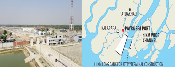
Payra Sea Port is the 3rd seaport of Bangladesh located in general area in between latitude 21.9890 North and longitude 90.2792 East on the bank of Rabnabad Channel under Kalapara, a sub district of Patuakali. In order to increase the economic activities in the central zone and meet the future demand, Payra Sea Port Act 2013 was passed in National Parliament on 10 November 2013. Honourable Prime Minister Sheikh Hasina inaugurated country’s 3rd seaport named as “Payra Sea Port” at Rabnabad Channel at Patuakhali district on 19 November 2013.
Government has taken Short, Mid & Long-Term Plan to develop a state of art modern seaport. As Short-Term Plan, Payra Port Authority is set operate the port activities by offloading cargos from motherships at outer/inner anchorage and transported to the hinterlands through river routes. All the necessary preparations like Custom Clearance Facilities, VHF communication, Banking, enlistment of Ship handling operators, C&F, Shipping agent, Channel Marking with Laying of Buoys at River and approach channel, Marking of Payra inner and outer Anchorage area, Implementation of ISPS code, UN Locator Code, and port security including a Bangladesh Coastguard station with high speed vessel and manpower etc have been completed.
Under Long Term Plan, by 2023 the port would be fully operational with a 16 m channel where minimum 10 km container & other terminals with all other associated facilities like establishing EEZ, Airport, Port city, Dockyard/Shipyard, Echo Tourism etc centring to the port. The Port authority has taken a mega budget estimate under the Long-term plan by phases to complete the envisioned infrastructural facilities and make the port fully operational by 2015.
Presently the port users are using River Route connecting to Dhaka and other districts of the country. In the river route, vessels more than 4-meter draught with bulk cargo are plying day and night irrespective of tide. Various commodities including food grain, cement, fertilizer and other bulk are transported from Payra to Dhaka and other destinations through internal waterways.
PPA’S objective focuses mainly on providing necessary services and facilities to the port users efficiently and effectively at competitive price. Though PPA started its Ltd scale port operations by offloading bulk cargoes at inner/outer anchorage, with the passage of time PPA is going to handle maximum volume of container and bulk cargoes of Bangladesh using the geographical advantages, good hinterland connectivity
Port website: http://ppa.gov.bd/
|
Port Location and Contact |
|
|---|---|
|
Country |
Bangladesh |
|
Province or District |
Patuakhali |
|
Nearest Town or City with Distance from Port |
Kalapara 5 km |
|
Port's Complete Name |
Port of Payra |
|
Latitude |
21.9890 N |
|
Longitude |
90.2792 E |
|
Managing Company or Port Authority |
Payra Port Authority |
Port Picture
List of Officers- PPA
|
Sl |
Name |
Designation |
Contact Details |
|---|---|---|---|
|
1 |
Commodore M Jahangir Alam, (E), NUP, ndc, psc, BN |
Chairman |
+88029348421 Fax:+88029349175 |
|
2 |
Commodore Md. Ashraful Haque Chowdhury, psc, BN |
Member (Harbour & Marine) |
|
|
3 |
Captain M. Muniruzzaman, (E), BN |
Member (Engineering and Development) |
02-9350125 |
|
4 |
Commander M Rafiul Hassain (TAS) psc, BN, (Rtd.) |
Member (Admin & Finance) |
02-9349175 |
|
5 |
Mohiuddin Ahmed Khan (Joint Secretary) |
Director (Administration) |
|
|
6 |
Md. Elias Reja |
Chief financial and accounting officer |
|
|
7 |
Quazi Wasif Ahmad |
Chief Engineer |
|
|
8 |
Commander Haider Jahan Khon Emon (H-1), psc, BN |
Chief Hydrographer |
|
|
9 |
Md. Nasir Uddin |
Deputy Ch. Engineer (Jetty & Harbour) |
|
|
10 |
Captain SM Sharifur Rahaman |
Dock Master |
|
|
12 |
Md. Saifur Rahman |
Joint Chief Planning |
|
|
13 |
Tayebur Rahman |
Deputy Director (Admin) |
|
|
14 |
Azizur Rahman |
Deputy Director (Traffic) |
|
|
15 |
Captain Asif Ahmed |
Pilot |
|
|
16 |
Mohammad Soadrul Amin |
Deputy Director, MIS |
|
|
17 |
Mostafa Ashique Ali |
Executive Engineer (Jetty) |
|
|
18 |
Md. Abul Kalam Azad Molla |
Executive Engineer (Harbour) |
|
|
19 |
Azizur Rahman |
Assistant Director (Admin) |
|
|
20 |
Md. Rajibul Hasan |
Assistant Director (Accounts) |
|
|
21 |
Md. Sohel Mir |
Assistant Director (Security) |
|
|
22 |
Md. Sajidul Islam Sobuj |
Assistant Secretary (Coordination) |
|
|
23 |
Md. Asadulla Ashik |
Assistant Engineer (Electrical) |
|
|
24 |
S M Imties Islam |
Superintendent (Light and Mooring) |
|
|
25 |
Md. Aminul Haque |
Assistant Chief (Prog) |
01515201401 |
|
26 |
Anup Kumar Sarker |
Medical Officer |
|
|
27 |
Delwar Hosen |
Personal Secretary |
|
|
28 |
Md. Rokibul Islam |
Security Officer |
Port Facilities and Infrastructure
Present Facilities of Port
As the port is under construction and lot of development works are going on to enrich the capacity and facilities of the port. However, some of the existing facilities are shown below:
|
Jetty |
ONE jetty (80M) to be used as service Jetty for own use and Cargo handling usage in small scale. |
|---|---|
|
Draught |
Maximum allowable draught of ships at Jetty is 6 M only |
|
Storage |
One Transit shed of 1,00,000 Sq. Ft |
|
Infrastructure |
Office/Admin building, Officer’s BOQ, Staff Accommodation, Multi-purpose Complex, Generator, Sub-station and some other small buildings and Shades have been constructed. |
|
Handling Equipment |
|
Port General Information
|
Port various Data
|
Hydrographic Data |
|
|---|---|
|
Salinity |
Salinity at Rabnabad Channel varies from 0.1 gms/1000c.c at low water to 0.2gms/ 1000c.c at high water during monsoons and from 2.5gms/1000c.c at low water to 16.5gms/1000c.c at high water during dry season. Salinity at Kajal river varies from 0.15gms/1000c.c at low water to 3.3gms/1000c.c at high water during monsoon and from 10gms/1000cc at low water to 27 gms/1000cc at high water during dry season. |
|
Width of Channel |
The width of the navigational channel (5.0m. contour) varies from place to place. From fairway to the mouth of Rabnabad Channel there is no restriction of Navigational width. A minimum of 250 m Channel width is maintained in Kajal- Tetulia route. |
|
Wind Velocity |
The weather in Bangladesh is largely governed by the monsoon. The prevailing wind directions are from South to South East during the months of April through September. After taking easterly direction for a while the wind turns to the northerly and north-easterly directions, the later prevail from November to January. During the months of February and March, winds turn via westerly direction back to the Southerly to South Easterly. In excess of 20 Knots/ Beaufort wind scale 5 prevails for 6 percent to time while those in excess of 30 Knots/Beaufort wind scale 7 persists for about 0.1 percent of the time during cyclones i.e. During the transition between monsoon and dry seasons in May, October, and November. The area of Payra port experienced four severe Cyclonic water surges during the last 44 years. In 1960 & 1963 speeds recorded were 125 Knots Max. In 1970 and 1991 speeds were recorded 138 Knots max. and 180 Knots max. respectively. |
|
Tidal Ranges |
The tides are important for navigations as determining the possibility of crossing the shallow area between Payra Fairway and the Meghna entrance at Hizla point and the Bars within Port Limit. The tides are semi-diurnal with prominent diurnal effect. The approx. Tidal Ranges at Rabnabad Channel and Amirganj (Meghna juncture) from Chart Datum (ISLWL – Indian Spring Low Water Level which is 1.673m below mean sea level) are as follows: At Rabnabad Channel: 0.8m.-3.5m. (above ISLWL) At Amirganj (Meghna juncture): 0.7m-2.8m. (above ISLWL). |
|
Night Navigation |
The entire channel is demarcated by let- buoys. There is no limitation for night navigation for entering/leaving harbour. |
|
Waves |
The waves are generally low shown distinct relation with the wind. Maximum wave heights over 2m were recorded only on a few days during the small parts of days. The wave periods vary between 3-4 seconds of waves of about 0.5m and about six seconds for waves of 2m. These are from an observation made by NEI (Netherlands Economic Institute) 1972–1977. During the months May to October freshets are expected, Freshets are caused by the normal velocity of flow of ebb tide augmented by the flow of an additional volume of water that drains into the river from the catchment area. Freshets are expected when rainfall intensity reaches 200mm in 24 hours. The density of water varies at each turn of the tide. Masters are advised to obtain the Circular from the local agents and follow the instructions closely. |
|
Anchorage |
A wide anchorage is established at the outer and inner Anchorage of PPA: LONGITUDE/LATITUDE
|
Port Performance
Before being fully operational the port has started its activities. Since Nov 2013 till Mar 2019 the port has managed following 32 ships:
|
Sl |
Name of Vessel |
Flag |
DWT |
L x B |
Draught |
D.O.A |
Quantity |
|---|---|---|---|---|---|---|---|
|
1 |
Banglar Mamata |
Bangladesh [BD] |
15,877 |
154.16m × 22.26m |
6.95m |
15-Nov-13 |
|
|
2 |
Fortune Bird |
Hong Kong [HK] |
55,640 |
189.99m × 32.26m |
6.80m |
1-Aug-16 |
20810MT |
|
3 |
FS Beach |
Vietnam [VN] |
8,215 |
136.4m × 20.2m |
7.00m |
14-Aug-16 |
12502MT |
|
4 |
Battang Hari 30 |
Indonesia [ID] |
1,630 |
95m × 19m |
5.00m |
6-Sep-16 |
1 unit |
|
5 |
Matsumae |
Panama [PA] |
9,998 |
124.56m × 21.2m |
5.00m |
27-Sep-16 |
106Pckg |
|
6 |
Kulsamut |
Thailand [TH] |
12,665 |
140.5m × 20.8m |
7.50m |
7-Oct-16 |
8000 MT |
|
7 |
Teng Hang |
Hong Kong [HK] |
35,023 |
179.88m × 28.4m |
7.30m |
17-Oct-16 |
26000 MT |
|
8 |
Combi Dock 1 |
Antigua Barbuda |
10,480 |
169.4m × 25.73m |
6.20m |
30-Oct-16 |
1 Unit |
|
9 |
Zealand Rotterdam |
Netherlands [NL] |
57,157 |
190m × 32.26m |
7.30m |
30-Jan-17 |
21195 MT |
|
10 |
Desert Unity |
Marshall Is [MH] |
54,043 |
189.99m × 32.26m |
7.30m |
2-Feb-17 |
14700 MT |
|
11 |
Canary |
Marshall Is [MH] |
57,825 |
189.99m × 32.3m |
6.60m |
14-Mar-17 |
17500 MT |
|
12 |
Safesea Neha II |
Liberia [LR] |
53,389 |
189.99m × 32.26m |
7.40m |
2-Oct-17 |
21300 MT |
|
13 |
Wish Way |
Panama [PA] |
21,243 |
156m × 36m |
7.00m |
25-Nov-17 |
1 Unit |
|
14 |
Dubai Ambassador |
Panama [PA] |
56,060 |
189.99m × 32.26m |
5.80m |
17-Dec-17 |
12000 MT |
|
15 |
Zhen Hua 15 |
Hong Kong [HK] |
46,671 |
233.3m × 42m |
8.30m |
4-Jan-18 |
6547.16 MT |
|
16 |
KSL Lake Hill |
Panama [PA] |
3,375 |
81m × 13.6m |
5.50m |
17-Jan-18 |
3000 MT |
|
17 |
Icarius |
Marshall Is [MH] |
55,921 |
189.99m × 32.26m |
7.05m |
10-Feb-18 |
20000 MT |
|
18 |
Kyriakos |
Panama [PA] |
29,926 |
171.45m × 27.02m |
6.95m |
26-Feb-18 |
14800 MT |
|
19 |
NK Khaleda |
Togo [TG] |
2,594 |
83.78m × 12.7m |
5.40m |
1-Mar-18 |
2400 MT |
|
20 |
Yin Fu |
China [CN] |
48,909 |
190m × 32.26m |
6.60m |
13-Apr-18 |
20000 MT |
|
21 |
Tan Binh 136 |
Vietnam [VN] |
29,887 |
170.7m × 27m |
7.20m |
19-Apr-18 |
17000 MT |
|
22 |
Knossos |
Malta [MT] |
56,763 |
189.99m × 32.26m |
7.30m |
12-Aug-18 |
22000 MT |
|
23 |
Development Way |
Panama [PA] |
31,287 |
215.00mx34.04m |
12.30m |
16-Oct-18 |
|
|
24 |
Sabada |
Moldova [MD] |
6,507 |
102.79mx17.03m |
7.15m |
12-Nov-18 |
6000 MT |
|
25 |
Equinox Agnandoussa |
Cayman Island [KY] |
58,680 |
197.00mx32.26m |
12.90m |
20-Nov-18 |
56810 MT |
|
26 |
Maria |
Marshall Is [MH] |
57,070 |
189.99mx32.26m |
12.10m |
30-Nov-18 |
50000 MT |
|
27 |
Tiger Hebei |
Hong Kong [HK] |
63,483 |
199.9m × 32.32m |
13.50m |
19-Dec-18 |
62,290 MT |
|
28 |
Mimi Selmer |
Marshall Is [MH] |
55,711 |
189.99m × 32.3m |
12.30m |
23-Jan-19 |
51,922 MT |
|
29 |
Xin Chen Hai Yang |
China [CN] |
24,242 |
153.46m × 38.6m |
6.00m |
31-Jan-19 |
4 Unit |
|
30 |
Sabada |
Moldova [MD] |
6,507 |
102.79mx17.03m |
6.93m |
19-Feb-19 |
6000 MT |
|
31 |
Sabada |
Moldova [MD] |
6,507 |
102.79mx17.03m |
6.95m |
17-Mar-19 |
6000 MT |
|
32 |
Ocean Bao |
Hong Kong [HK] |
63,577 |
199.9m × 32.26m |
12.80m |
27-Mar-19 |
58,306 MT |
Important News of the PPA
|
Sl |
Title |
|
1 |
|
|
2 |
|
|
3 |
List of Future development Projects
|
Sl |
Project Name |
|---|---|
|
1 |
Developing Infrastructure Support Facilities (DISF) |
|
2 |
PPA Master Plan |
|
3 |
Payra Port First Terminal (PPFT) |
|
4 |
Rabnabad Channel Capital and Maintenance Dredging of Payra Port |
|
5 |
Coal/Bulk Terminal (CBT) |
|
6 |
Multipurpose Terminal (MPT) |
