
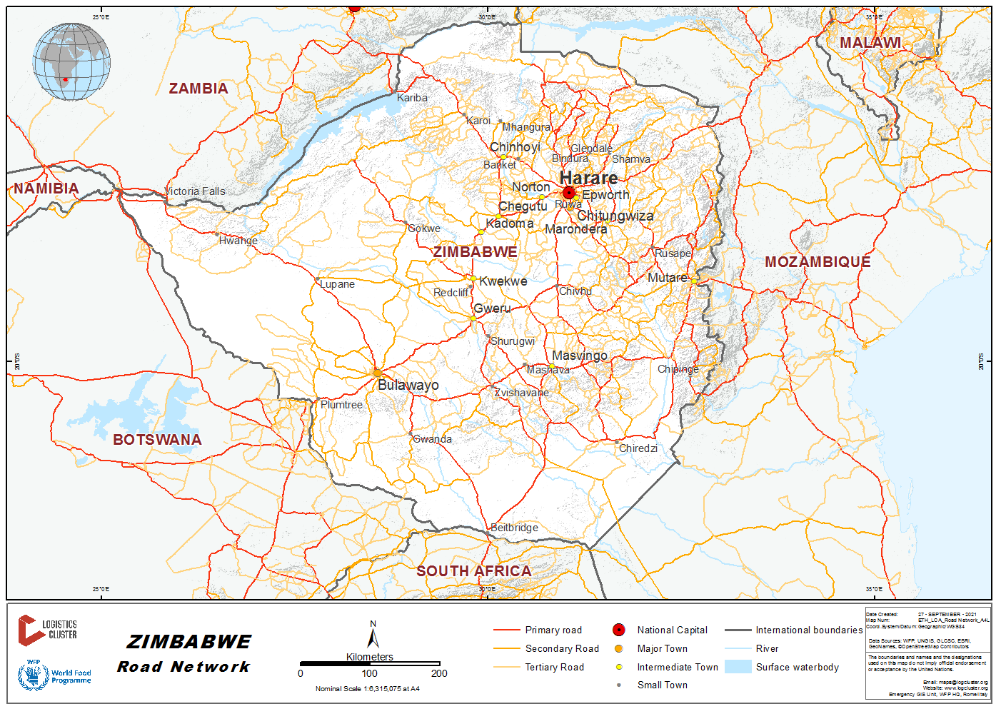
Road transport is the dominant means of transport in Zimbabwe. Most of the traffic and trade (80% by volume) is transported by road. More than 70% of Zimbabwe regional trunk roads and primary roads were built in the 1960's and early 70's and most of them have exceeded their 20 year design life. Lack of financial resources to reconstruct or rehabilitate the aging road network and the unavailability of good quality gravel is compounding the problem.
Zimbabwean roads are managed, maintained and operated by the Zimbabwe National Road Administration (ZINARA). ZINARA is responsible for managing the Road Fund and disbursing to the following road authorities: Department of Roads in the Ministry of Transport and Infrastructure Development, responsible for trunk roads; Rural District and Urban Councils, responsible for urban roads; and the District Development Fund, responsible for rural roads. The country's national highways are currently undergoing dualisation albeit at a slow pace due to funding constraints. Large requirements in support of road maintenance have necessitated the introduction of toll gate fees to complement the limited national budget resources. The introduction of toll fees has provided additional resources for the maintenance and rehabilitation of the Zimbabwean road network. Paved roads link the major urban and industrial centres, but the condition of urban roads and the unpaved rural road network has deteriorated significantly over the years for lack of maintenance.
The country has a lot of haulage trucks that are readily available for lease and use by UN, NGOs, the private sector as well as government. WFP and partners have databases for such service providers. Seasonal demands and supply variations have little effects on the transport rates. Fuel price hike has a knock on effect on the transport charges.
For contact information for the relevant government authorities, please see the following link: 4.1 Zimbabwe Government Contact List.
For more information on the Zimbabwe road network, please see the following attachment: Additional Zimbabwe Road Network Information
Distance Matrix
|
Distances from Capital City to Major Towns (km) |
||||||||
|---|---|---|---|---|---|---|---|---|
|
Harare |
Bulawayo |
Gweru |
Mutare |
Chinhoi |
Masvingo |
Beitbridge |
Vic Falls |
|
|
Harare |
439 |
275 |
263 |
115 |
292 |
580 |
878 |
|
|
Bulawayo |
439 |
164 |
577 |
425 |
280 |
321 |
439 |
|
|
Gweru |
275 |
164 |
405 |
261 |
164 |
403 |
603 |
|
|
Mutare |
263 |
577 |
405 |
378 |
297 |
585 |
1,016 |
|
|
Chinhoyi |
115 |
425 |
261 |
378 |
407 |
664 |
864 |
|
|
Masvingo |
292 |
280 |
164 |
297 |
407 |
288 |
719 |
|
|
Beitbridge |
580 |
321 |
403 |
585 |
664 |
288 |
760 |
|
|
Victoria Falls |
878 |
439 |
603 |
1,016 |
864 |
719 |
760 |
|
Travel Time Matrix
|
Travel Time from Capital City to Major Towns (Hrs) |
||||||||
|---|---|---|---|---|---|---|---|---|
|
Harare |
Bulawayo |
Gweru |
Mutare |
Chinhoi |
Masvingo |
Beitbridge |
Victoria Falls |
|
|
Harare |
5 hrs |
3 hrs |
3 hrs |
1.2 hrs |
3 hrs |
6 hrs |
10 hrs |
|
|
Bulawayo |
5 hrs |
2 hrs |
6 hrs |
5 hrs |
3 hrs |
3 hrs |
5 hrs |
|
|
Gweru |
3 hrs |
2 hrs |
4 hrs |
3 hrs |
1.5 hrs |
4 hrs |
6 hrs |
|
|
Mutare |
3 hrs |
6 hrs |
4 hrs |
4 hrs |
3 hrs |
6 hrs |
11 hrs |
|
|
Chinhoyi |
1.2 hrs |
5 hrs |
3 hrs |
4 hrs |
4 hrs |
7 hrs |
9 hrs |
|
|
Masvingo |
3 hrs |
3 hrs |
1.5 hrs |
3 hrs |
4 hrs |
3 hrs |
8 hrs |
|
|
Beitbridge |
6 hrs |
3 hrs |
4 hrs |
6 hrs |
7 hrs |
3 hrs |
8 hrs |
|
|
Victoria Falls |
10 hrs |
5 hrs |
6 hrs |
11 hrs |
9 hrs |
8 hrs |
8 hrs |
|
Road Security
The road security in Zimbabwe is classified as Good.
Weighbridges and Axle Load Limits
Weighbridges can be found across the country but those that affect road transport can be found at each border crossing. Here the V.I.D. will inspect trucks and those they assess to be overweight are weight at their respective depots.
|
Axle load limits (kg) |
|
|---|---|
|
Gross Vehicle Mass (in any case) |
56,000 |
|
Truck with 1 axle |
8,000 |
|
Truck with 2 axles |
18,000 |
Road Class and Surface Conditions
Road Classifications
By Use there are four classes of roads:
- Regional Trunk Road Network-Provides vital links to provincial capitals and connects Zimbabwe to its neighbouring countries
- Primary Road-Provides links to urban centres and provincial centres
- Secondary Road-Provides link between service centre, growth points and primary roads
- Feeder Road-These are inter-district and provide links to rural service centres
Total road lengths in Zimbabwe come to 97,267 km. Paved roads make up 18,481 km (20.4% surfaced, 14% gravel), and unpaved roads amount to 78,786 km (65.6% earth roads). The following table shows distribution of roads by authority:
|
Road Authority |
Surfaced (km) |
Gravel (km) |
Earth (km) |
Total (km) |
|
|---|---|---|---|---|---|
|
Department of Roads |
8,900 |
7,577 |
1,985 |
18,462 |
|
|
Urban Councils |
8,164 |
26 |
4 |
8,194 |
|
|
Rural District Councils |
356 |
2,133 |
33,988 |
36,477 |
|
|
District Development Fund |
2,161 |
19,914 |
22,075 |
||
|
TOTALS |
17,420 |
11,897 |
55,891 |
7,577 |
|
| Classification | Administering Agency |
|---|---|
| Regional Roads | Department of Roads (Ministry of Transport) |
| Primary Roads | Department of Roads (Ministry of Transport) |
| Secondary Roads | Department of Roads (Ministry of Transport) |
| Tertiary Roads | Rural District Councils |
| Urban Roads | Municipalities or Rural District Councils |
There are 88,100 km of classified roads in Zimbabwe, 17,400 km of which are paved. About 5% of the network is classified as primary roads and has some of the most trafficked arterials that link Zimbabwe with its neighbours. A portion of the Pan-Africa Highway passes through Zimbabwe. This part of the road network plays a major role in the movement of the country’s imports and exports as well as transit freight.
Some 14% of the network is classified as secondary roads that link the main economic canters within the country, enabling internal movement of people and goods. The primary and secondary roads are collectively referred to as the trunk road system; they carry over 70% of the vehicular traffic (measured in vehicle kilometres) and they are managed by the Department of Roads (DoR). A little more than 70% of the network is made up of tertiary feeder and access roads that link rural areas to the secondary road network. These are managed by the District Development Fund (DDF) and by the District Councils (DC).
The tertiary access roads, together with the unclassified tracks, typically with traffic volumes below 50 vehicles per day, provide for the intra-rural access movements. They link rural communities to social economic amenities, such as schools, health centres, and markets, and enable government services to reach rural areas. The remaining 9% of the network are urban roads managed by urban councils. The road density in Zimbabwe is about 0.23 km per square km. This is high compared with many developing countries; it is comparable to that of the high income, non-OECD countries and lower middle-income countries. Only OECD countries have a substantially higher road density than Zimbabwe.
The implication is that a relatively high proportion of the population has access to the road network of the country. Moreover, Zimbabwe has a very substantial road network relative to its gross domestic product (GDP). The replacement value of the road network asset is estimated at about $10 billion, equivalent to almost three times the current level of GDP. This ratio is high in comparison with many developing countries, and it gives some insight into the current large economic burden of maintaining the road network.
The Department of National Parks and Ministry of Lands have roads within their jurisdiction, but these are considered as private since they are not declared roads.
The Department of Roads design surfaced roads for a 20-year Design Life; however, many roads have outlived their design life. The Department of Roads classifies its roads by surface type, by estimated traffic during its design life and use. By surface type the following classes apply:
|
Wide Mat Surfaced Shoulders (WMSS) |
12 m surfacing width with 12 m formation width |
|---|---|
|
Wide Mart Gravel Shoulders (WMGS) |
10 m surfacing width with 12 m formation width |
|
Narrow Mart (NM) |
7 m surfacing width with 10 m formation width |
|
Gravel (GR) |
no surfacing with 8 m formation width |
|
Earth (ER) |
- |
The other type of classification is by Estimated Traffic based on
Equivalent Standard Axles of 10 tons per axle during the
20-year design life of the road:
|
Class |
Meaning |
Cost (based on last recorded figures |
|---|---|---|
|
3M |
3 million standard axles over twenty years |
20 |
|
1M |
1 million standard axles over twenty years |
15 |
|
0.3M |
3 hundred thousand standard axles over twenty years |
12.5 |
|
0.1M |
1 hundred thousand standard axles over twenty years |
7.5 |
Following is a table showing distribution by surface type and respective Province (km):
|
Province |
WMSS |
WMGS |
NM |
GR |
ER |
TOTAL |
|---|---|---|---|---|---|---|
|
Manicaland |
507.4 |
707.1 |
71.4 |
1,178 |
283.1 |
2,747 |
|
Mashonaland central |
102.8 |
531.9 |
231.2 |
844.2 |
83 |
1,793.1 |
|
Mashonaland east |
143.1 |
626.3 |
195.9 |
654.3 |
194.3 |
1,813.9 |
|
Mashonaland west |
307.7 |
717.8 |
295.5 |
1,037.7 |
17 |
2,375.7 |
|
Masvingo |
177.2 |
863.1 |
74 |
938.9 |
82.7 |
2,135.9 |
|
Matabeleland North |
51.8 |
777.3 |
464.6 |
1,256.4 |
406.9 |
2,957 |
|
Matabeleland South |
221.9 |
618.9 |
100.2 |
866.9 |
425.7 |
2,233.6 |
|
Midlands |
188 |
758.1 |
167 |
800.7 |
492.7 |
2,406.5 |
|
TOTAL KMS |
1,699.9 |
5,600.5 |
1,599.8 |
7,577.1 |
1,985.4 |
18,462.7 |
The Regional Trunk Road Network (RTRN) has a total of 3,174.9 km, of which 2,573.9 km (81%) have outlived the 20 year design life but have maintained a good condition due to spot rehabilitation where necessary. The following table shows trunk road network:
|
Road |
Linking Neighbouring Country |
Distance (km) |
Age (years) |
|---|---|---|---|
|
Harare-Chirundu |
Zambia |
352.1 |
30 |
|
Harare-Nyamapanda |
Mozambique |
237.5 |
32 |
|
Harare-Mutare |
Mozambique |
262.8 |
49 |
|
Harare-Masvingo |
South Africa |
292.3 |
54 |
|
Harare-Gweru* |
Internal |
275.3 |
52 |
|
Mvuma-Gweru* |
Internal |
82.8 |
23 |
|
Masvingo-Beitbridge |
South Africa |
282.4 |
32 |
|
Gweru-Bulawayo* |
Internal |
164 |
50 |
|
Bulawayo-Beitbridge |
South Africa |
321.7 |
50 |
|
Bulawayo-Plumtree |
Botswana |
110.4 |
52 |
|
Bulawayo-Victoria Falls |
Zambia/Botswana |
438.8 |
52 |
|
Mutare-Forbes border |
Mozambique |
8.3 |
32 |
|
Rutenga-Boli-Sango |
Mozambique |
150 |
>25 |
|
Chivhu-Nyazura* |
Internal |
196.6 |
25 |
NB: * implies roads linking provincial capitals.
Bridges
Bridges built within the primary road network are full operational throughout the year. One bridge on the route between Chiredzi and Tanganda Holt crossing the Save River is low enough for water to flood the road in an event of a flash flood. Secondary roads regularly succumb to flooding in the wet months. The Victoria Falls, Birchenough, Otto Beit (Chirundu) and Beit (Beitbridge) bridges have stood the test of time but are closed when there is a need for maintenance. Security is very tight on all bridges by both the host country i.e. Zimbabwe and the neighbouring nations.
Transport Corridors
Transport corridors correspond to the international corridors as described below.
- Beitbridge –Harare
- Beitbridge –Bulawayo
- Beitbridge – Mutare
- Mutare –Harare
- Plumtree –Bulawayo
- Plumtree –Harare
- Chirundu –Harare
- Harare – Nyamapanda
More information on Zimbabwe road classifications, transport corridors, bridges, weighbridges, etc., please see the following attachment: Additional Zimbabwe Road Network Information
