
Overview
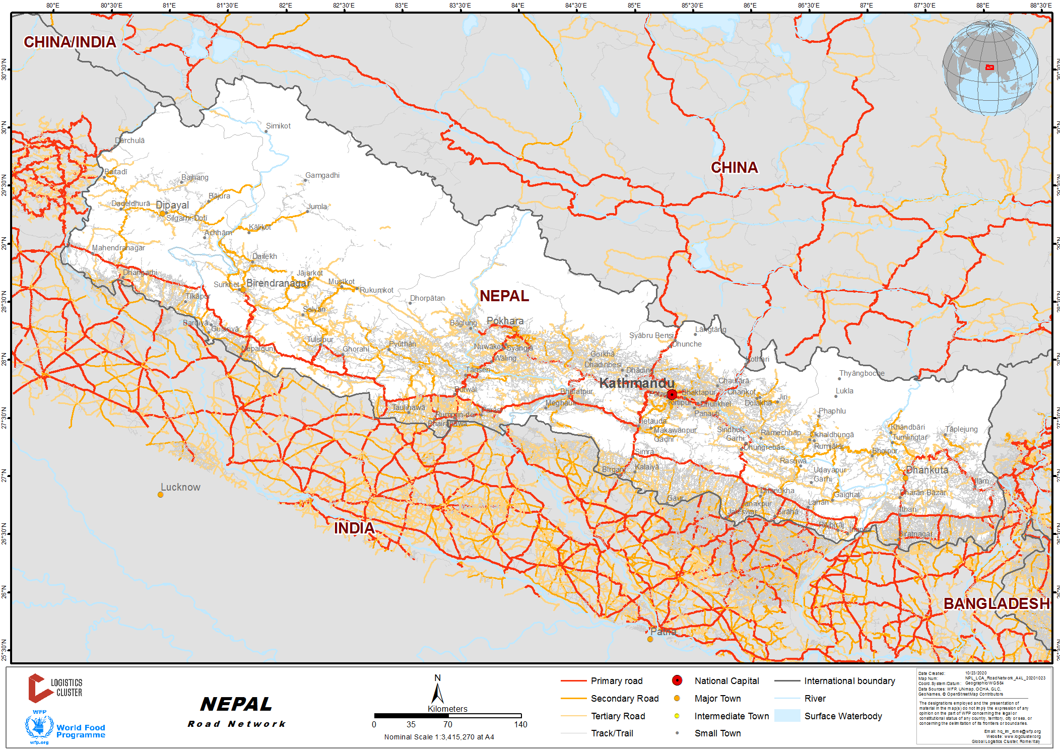
Roads are the predominant mode of transport in Nepal. Road network of Nepal is categorized into the strategic road network (SRN), which comprises of highways and feeder roads, and the local road network (LRN), comprising of district roads and Urban roads. Nepal’s road network consists of about 64,500 km of roads. Of these, about 13,500 km belong to the SRN, the core network of national highways and feeder roads connecting district headquarters.

(Picture : Nepal Road Standard 2070)
The network density is low, at 14 kms per 100 km2 and 0.9 km per 1,000 people. 60% of the road network is concentrated in the lowland (Terai) areas. A Department of Roads (DoR’s) survey shows that 50% of the population of the hill areas still must walk two hours to reach an SRN road. Two of the 77 district headquarters, namely Humla, and Dolpa are yet to be connected to the SRN.
(Source: Sector Assessment [Summary]: Road Transport)
Primary Roads in Nepal
|
S.N. |
Rd. Ref. No. |
Name of Highway |
Length (km) |
Node Feature |
Remarks |
|
|---|---|---|---|---|---|---|
|
Start Point |
End Point |
|||||
|
1 |
H01 |
Mahendra Highway |
1027.67 |
Mechi Bridge, Jhapa Border |
Gadda chowki Border, Kanchanpur |
East to West of Country |
|
2 |
H02 |
Tribhuvan Highway |
159.66 |
Tribhuvan Statue, Tripureshwor |
Sirsiya Bridge, Birgunj Border |
Connects biggest Customs to Capital |
|
3 |
H03 |
Arniko Highway |
112.83 |
Maitighar Junction, KTM |
Friendship Bridge, Kodari Border |
Connects Chinese border to Capital |
|
4 |
H04 |
Prithvi Highway |
173.43 |
Naubise (TRP) |
Prithvi Chowk, Pokhara |
Connects Province 3 to Province 4 |
|
5 |
H05 |
Narayanghat - Mugling Highway |
36.16 |
Pulchowk, Naryanghat (PRM) |
Mugling |
Naryanghat to Mugling |
|
6 |
H06 |
Dhulikhel Sindhuli Bhittamod Highway |
198 |
Bhittamod border, Jaleshwor |
Dhulikhel (ARM) |
135.94 Km. completed, Major route to eastern part of Country |
|
7 |
H07 |
Mechi Highway |
268.06 |
Kechana Border, Bhadrapur |
Taplejung |
|
|
8 |
H08 |
Koshi Highway |
111.46 |
Rani Border, Biratnagar |
Hile |
|
|
9 |
H09 |
Sagarmatha Highway |
265 |
Kadmaha, Saptari (MRM) |
Solusalleri Solukhumbu |
53.97 km. completed |
|
10 |
H010 |
Siddhartha Highway |
181.22 |
Sunauli Border |
Prithvi Chowk, Pokhara |
|
|
11 |
H011 |
Rapti Highway |
196 |
Ameliya, Dang (MRM) |
Musikot, Rukum |
168.54 km Completed |
|
12 |
H012 |
Ratna Highway |
113.08 |
Jamuniya Border, Nepalgunj |
Bangesimal, Surkhet |
|
|
13 |
H013 |
Karnali Highway |
220 |
Surkhet, Bangesimal |
Jumla, Kalikot |
113 km Completed |
|
14 |
H014 |
Mahakali Highway |
320 |
Mohana Bridge, Dhangadhi Border |
Darchula |
307.76 km Completed |
|
15 |
H015 |
Seti Highway |
65.96 |
Syaule, Dadeldhura |
Samuwagad - In Safe Road |
Completed |
|
16. |
H017 |
Postal Highway |
1792 |
Kechana Kawal |
Dodhara |
Alternative road to H01, east to west in Terai, ongoing project |
|
17. |
|
KTM-Terai Fast Track (Expressway) |
|
Nijgarh, Bara |
Khokana, Lalitpur |
Prioritized Mega highway project |
|
18. |
H018 |
Pushpa Lal Highway |
1,776 |
Chiyabhanjyang, Panchthar |
Jhulalghat, Baitadi |
Alternative road to H01, east to west in mid-hills, ongoing project |
(Source: List of Strategic Road Network – National Highway Roads)
Major Road Construction Projects
Kathmandu Terai/Madhesh Expressway
The Expressway will be constructed by Nepali Army (NA). The Expressway consists of a dual carriageway with double lane high design speed highway. The overall 76.2 km (proposed) length stretches from Khokana (Lalitpur) to Nijgadh (Bara) interconnecting Kathmandu and Makwanpur district in between. The project has started and is planned to complete by May 2024.
(Source: Fast Track Road Project)
SASEC Road Connectivity Project
The South Asia Sub-Regional Economic Cooperation (SASEC) Road Connectivity Project is building alternative routes between the districts of Sunsari and Saptari to create year-round passable conditions along the East West Highway, especially across the Koshi River. The project is upgrading 73 km of bypass and border roads along the East-West Highway to two lanes and improving 114 km of another strategic roadway.
(Source: Nepal: South Asia Sub-regional Economic Cooperation Road Connectivity Project )
Construction of Major Highways Connecting East to West of Country
- Pushpa Lal (Mid Hill) Highway Project: Pushpalal Highway’s (H18) proposed length 1776 km would be the longest highway of Nepal once completed. 850 km of the 1776 km has been blacktopped. The government has aimed to accomplish the Mid-Hill Highway by the fiscal year 2022/2023.
- Madan Bhandari Inner Terai Highway: Inner Terai highway, an ongoing project once completed would extend 1200 km from east to west. The highway would run parallel to Mid Hill highway to the North and Mahendra Highway to the south.
- East-West Postal Highway: The East-West Postal Highway, popularly known as Hulaki Marga, connects 20 districts in the southern Terai belt. The highway extends 975 km from east to west. The project also includes another 817 kms of roads that will connect all Tarai districts. Construction work has started on the road sections in Province 2. The progress has been slow.
These projects once completed would relieve pressure on Mahendra Highway by being alternative routes to traverse east to west of the country.
|
Ministry in Charge |
Contact Names, Address & Email |
Telephone & Fax |
||
|---|---|---|---|---|
|
Ministry of Physical Infrastructure & Transport |
Mr. Shiva Hari Sapkota, Deputy Director General /Speaker Department of Roads Chakupat, Patan |
T: +977-1-5529075 F: +977-1-5529106 |
||
|
Summary of Role and Services DOR is responsible for management of motorized surface transport infrastructure i.e. road transport regarding planning, designing, construction and maintenance activities of Strategic Road Network (SRN). Thus, maintenance of roads is one of the major tasks of Department of Roads. Also, it continuously develops and expands existing SRN to improve existing access to District Headquarters. |
||||
| Ministry in Charge |
Contact Names, Address & Email |
Telephone & Fax |
||
|
Ministry of Physical Infrastructure & Transport |
Ram Prasad Gauli, Info Officer/ Office Secretary Roads Board Nepal N.K. Singh Marga, Minbhawan, Kathmandu Nepal Email: info@rbn.org.np Web: rbn.org.np |
T: +-977-1-4493515 F: +-977-1-4493542 |
||
|
Summary of Role and Services RBN is a self-governing, self-sustaining and organized entity based on Public-Private Partnership [PPP] model. The major function of RBN is to collect, manage and allocate fund for road maintenance to the Road Agencies. Board Requests Annual Road maintenance plan (ARMP) from Road Agencies to consolidate the report into one Integrated Annual Road maintenance plan (IARMP) to better allocate the fund. |
||||
For more information on government contact details, please see the following link: 4.1 Government Contact List.
Distance Matrix
|
Distances from Capital City to Province Capitals (km) |
||||||||
|---|---|---|---|---|---|---|---|---|
|
Kathmandu |
Hetauda |
Janakpur |
Biratnagar |
Bhairahawa |
Pokhara |
Birendranagar |
Dhangadhi |
|
|
Kathmandu |
|
82 |
244 |
373 |
261 |
202 |
584 |
656 |
|
Hetauda |
82 |
|
165 |
317 |
194 |
205 |
516 |
588 |
|
Janakpur |
244 |
165 |
|
201 |
449 |
367 |
678 |
751 |
|
BIratnagar |
373 |
317 |
201 |
|
508 |
519 |
803 |
903 |
|
Bhairahawa |
261 |
194 |
449 |
508 |
|
179 |
333 |
406 |
|
Pokhara |
202 |
205 |
367 |
519 |
179 |
|
478 |
551 |
|
BIrendranagar |
584 |
516 |
678 |
803 |
333 |
478 |
|
243 |
|
Dhangadhi |
656 |
588 |
751 |
903 |
406 |
551 |
243 |
|
|
Travel Time from Capital City to Province Capitals (hours) |
||||||||
|---|---|---|---|---|---|---|---|---|
|
Kathmandu |
Hetauda |
Janakpur |
Biratnagar |
Bhairahawa |
Pokhara |
Birendranagar |
Dhangadhi |
|
|
Kathmandu |
|
3.25 |
6.75 |
8.75 |
7.50 |
5.50 |
13.25 |
14.50 |
|
Hetauda |
3.25 |
|
3.75 |
6.50 |
4.5 |
5 |
11.25 |
12.50 |
|
Janakpur |
6.75 |
3.75 |
|
4.25 |
10 |
8.50 |
14.75 |
16 |
|
BIratnagar |
8.75 |
6.50 |
4.25 |
|
11 |
11.50 |
17.75 |
18.75 |
|
Bhairahawa |
7.50 |
4.5 |
10 |
11 |
|
5.50 |
7.25 |
8.50 |
|
Pokhara |
5.50 |
5 |
8.50 |
11.50 |
5.50 |
|
11.75 |
12.75 |
|
BIrendranagar |
13.25 |
11.25 |
14.75 |
17.75 |
7.25 |
11.75 |
|
5.75 |
|
Dhangadhi |
14.25 |
12.5 |
16 |
18.75 |
8.5 |
12.75 |
5.75 |
|
Road Security
The risk posed by the treacherous slope of mountains, the narrow width of the lanes, sharp corners and negligence and inexperience of drivers lead to approximately 4,622 annual traffic fatalities. Nepal’s fatality rate16 per 100K people and 400 per 100k registered vehicle is one of the highest rates in the continent and the world (WHO:2018). Road quality and frequent construction projects partially act as a control mechanism to limit speeding. Motorcycle accidents are frequent.
General strikes, or Bandhs, can involve blockage and shutdown of major roads. It is advisable to avoid travel during these strikes. The link provides the live data on fatality on the roads of Nepal
WHO 2018: Deaths on the Road.and Global Status Report On Road Safety 2018
Weighbridges and Axle Load Limits
The Department of Transport Management (DoTM) is mandated to control vehicle overloading in Nepal. A basic policy of vehicle overloading control has been included in National Transport Policy (2002) by the Government of Nepal, Ministry of Physical Infrastructure and Transport. However, no weighbridges are installed and operated by DoTM at present. The Federation of Truck Transport Entrepreneurs Nepal (FTTEN) is operating fifteen (15) weighbridges in major freight routes.
Medium-sized trucks (seven to ten-ton payload) operate over two-lane asphalt roads at relatively low average speeds, in the range of 200 to 400 km per day. The movement of containers on the Nepal roadways is limited due to the terrain and condition of the roads. Most of the trucks used in cross-border movements are 2-3 axle (six or ten wheel) trucks carrying payloads up to 18 MT. Trucks carrying bulk cargo are generally overloaded, causing additional damage to roads.
(Source: Road Transport Safety and Axle Load Control Study in Nepal)
|
Axle Load Limits (MT) |
Nepal |
India |
|---|---|---|
|
Truck with 2 Axles (4 wheeled) |
12 |
|
|
Truck with 2 Axles (6 wheeled) |
16.2 |
19 |
|
Truck with 3 Axles |
25 |
28.5 |
|
Truck with 4 Axles (12-Wheeled) |
31 |
36 |
|
Tridem with 3 Axle (12 wheeled) |
24 |
|
|
Semi-trailer with 4 Axles |
30 |
40 |
|
Semi-trailer with 5 Axles |
40.2 |
46 |
|
Semi-trailer with 6 Axles |
55 |
|
|
Truck & Drawbar Trailer with 4 Axles |
42 |
|
|
Truck & Drawbar Trailer with 5 Axles |
51.5 |
|
|
Truck & Drawbar Trailer with 6 Axles |
55 |
|
|
Truck & Drawbar Trailer with 7 Axles |
(Source: https://www.dotm.gov.np/MainData/ProcedureCodeofConduct)
Road Class and Surface Conditions
Road Functional Class
- Class-I roads: Have a divided carriageway and access control (Expressways) with Average Daily Traffic (ADT) of 20,000 Passenger Car Unit (PCU) or more in 20 yrs. perspective period. Design speed in plain terrain is 120 km/h.
- Class-II (arterial roads): Have ADT of 5,000-20,000 PCU in 20 yrs. perspective period. Design speed of this class of roads in plain terrain is 100 km/h.
- Class-III (collector roads): Have ADT of 2,000-5,000 PCU in 20 yrs. perspective period. Design speed of this class of roads in plain terrain is 80 km/h.
- Class-IV (local roads): Have ADT of less than 2,000 PCU in 20 yrs. perspective period. Design speed of this class of roads in plain terrain is 60 km/h.
Approximate correlation can be established between the administrative and functional classifications of the roads as follows
|
|
Plain and Rolling Terrain |
Mountainous and steep terrain |
|---|---|---|
|
National Highway |
I, II |
II, III |
|
Feeder Roads |
II, III |
III, IV |
(Source: Nepal Road Standard 2070)
Surface / Road conditions
Factors influencing road driving conditions in Nepal are:
- Construction quality: Many roads constructed have design flaws (narrow width lane, lack of safety barriers, lane markings or drainage systems, thin or low-quality surfacing). Increased vehicles traffic, heavy trucks and monsoon rains lead to quick deterioration and surface cracks and pot-holes.
- Maintenance: The Road Board Nepal oversees the maintenance of roads by respective Road Agencies. However, for many roads maintenance and repair is not carried out regularly.
- Weather: During rainy season the risk of landslides or floods that may block roads, is significantly increased. This affects immediate transportation and wreaks havoc on the longevity of the infrastructure.
- Ratna Highway is two-lane, black-topped highway in good condition.
- Karnali Highway is a vital transport link between two provinces in Nepal. This highway links the towns of Jumla, the Karnali capital, and Surkhet. Karnali Province is the largest, remotest and the least developed Province in Nepal. In general, the highway has two-lanes; the highway is both black-topped and earthen, and construction is still under progress.
- Feeder Roads (Nagma to Gamgadhi): Earthen, Work in Progress, Rocky Terrain
- Bhimdutta Highway (Dhangadi – Dadeldhura): Blacktopped, Good condition.
- Mechi Highway (H06) is two-lane highway with the length of 268 km. It is blacktopped and is in good condition. On its hilly section, the problem of landslides especially during rainy season should be considered.
- Koshi Highway (H08) is 390 km road envisioned as shortest north south corridor to connect China and India via Nepal. The road section from Biratnagar (India-Nepal Border) to Khandbari is blacktopped but beyond Khandbari to Kimanthanka (China-Nepal Border) the construction is ongoing. Hilly section of the highway faces the issue of landslides during rainy season.
- Araniko Highway (H03) is 115 km blacktopped highway connecting Kathmandu with Kodari (China-Nepal border). This highway is among the difficult highways of Nepal to navigate during rainy season.
- Siddhartha Highway (H10) is 181 km long blacktopped highway connecting Nepal India border at Siddharthanagar to Pokhara, a major city in Gandaki Province. Butwal-Palpa section at the hilly region of the highway consists of rocky terrain. Rockfalls and debris deposition are common. Landslides is frequent during rainy season.
- Mahendra Highway which traverses east to west of country, Prithivi Highway which connects Kathmandu with Pokhara, major tourist destination, Araniko highway which connects Kathmandu with Kodari, a town bordering China, Tribhuvan Highway which connects Kathmandu with Birgunj, a major business hub bordering India and Siddhartha Highway which connects Siddharthanagar, a town bordering India with Pokhara are the five busiest highways of Nepal.
- Nepal Access Constraints Maps : The National Logistics Cluster updates Road Access constraints maps periodically in the monsoon season, during flood/landslide emergencies.
Traffic capacity (Heavy, Heavy with trailer, Light vehicle, Motorbike) and any seasonal variations
The maximum dimensions of vehicles considered for design of roads in Nepal are as follows:
Maximum Width, m 2.50
Maximum Height, m 4.75
Maximum Length, m 18.00
Maximum single axle load, kilo Newton (kN) 100
Province 1
All the districts of Province No. 1 are connected by road, although some roads in high altitudes are not blacktopped and conditions of those roads worsen during the rainy season. Major highways of the province which connects plain land of Terai to high altitude regions are as follows:
- Mechi Highway: 268 km long two lanes freeway which connects Jhapato Taplejung. The main destinations along the highway include Prithivinagar, Bhadrapur, Duhagadhi, Budhabare, Kanyam, and Phikkal.
- Koshi Highway: Two lanes of road and 159 km long, starts from Biratnagarand connects Myanglung with it. Itahari, Dharan, Dhankuta, Bhedetar, Hile are the destinations along with highway.
- Sagarmatha Highway: Two lanes, 265 km long highway starts from Kadmaha of Province No. 2and connects Solukhumbu with it. Gaighat, Saune etc. are the destinations along with highway.
- Mahendra HighwayThe major East-West Highway of Nepal starts from Kakarbhitta of Province No. 1.
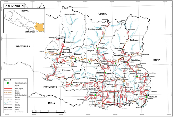
Road network in Province 1
|
Distances from Province 1 Capital to Major Towns (km) |
||||||||
|---|---|---|---|---|---|---|---|---|
|
Biratnagar |
Itahari |
Dharan |
Mechinagar |
Gaighat |
Birtamod |
Damak |
Suryodaya |
|
|
BIratnagar |
|
25 |
42 |
108 |
134 |
91 |
58 |
143 |
|
Itahari |
25 |
|
17 |
92 |
122 |
75 |
42 |
123 |
|
Dharan |
42 |
17 |
|
108 |
87 |
92 |
59 |
143 |
|
Mechinagar |
108 |
92 |
108 |
|
213 |
19 |
52 |
56 |
|
Gaighat |
134 |
122 |
87 |
213 |
|
230 |
164 |
248 |
|
Birtamod |
91 |
75 |
92 |
19 |
230 |
|
37 |
54 |
|
Damak |
58 |
42 |
59 |
52 |
164 |
37 |
|
87 |
|
Suryodaya |
143 |
123 |
143 |
56 |
248 |
54 |
87 |
|
|
Travel Time from Province 1 Capital City to Major Towns (hours) |
||||||||
|---|---|---|---|---|---|---|---|---|
|
Biratnagar |
Itahari |
Dharan |
Mechinagar |
Gaighat |
Birtamod |
Damak |
Suryodaya |
|
|
BIratnagar |
|
1 |
1.50 |
3 |
3 |
2.50 |
2 |
4 |
|
Itahari |
1 |
|
0.50 |
2.25 |
2.50 |
1.75 |
1 |
3.25 |
|
Dharan |
1.5 |
0.5 |
|
2.50 |
2.25 |
2.25 |
1.50 |
3.75 |
|
Mechinagar |
3 |
2.25 |
2.5 |
|
4.75 |
0.50 |
1.25 |
1.75 |
|
Gaighat |
3 |
2.5 |
2.25 |
4.75 |
|
5.25 |
3.50 |
5.75 |
|
Birtamod |
2.5 |
1.75 |
2.25 |
0.5 |
5.25 |
|
1 |
1.75 |
|
Damak |
2 |
1 |
1.50 |
1.25 |
3.50 |
1 |
|
2.50 |
|
Suryodaya |
4 |
3.25 |
3.75 |
1.75 |
5.75 |
1.75 |
2.5 |
|
Province 2
The East-West Highway runs longitudinally across the Province 2. All major cities of the province are connected to the highway. Janakpurdham, Rajbiraj , Birgunj and Gaur lie 25, 10, 24 and 42 km south of the Mahendra Highway, respectively. The Tribhuvan Highway is an important to link as it connects the province to Kathmandu and to India. The starting point of Tribhuvan Highway i.e. Birgunj is the most important international gateway and trade way for this province and the entire country and hence as the Tribhuvan Highway is also referred to as "The Gateway of Nepal". Birendra highway which is connected to Mahendra highway from headquarter of Rautahat district Gaur to the Chandranigahpur (the largest city of Rautahat) is 42km in length. However, to access the capital of Province 2, Janakpur city from Kathmandu the fastest suggested route is the Bisheshwor Prasad Koirala (BP) highway till Bardibas, Mahottari and then 1 h 12 min (43.9 km) via E - W Hwy/AH2 and Dhulikhel Sindhuli Bhittamod Rajmarg.
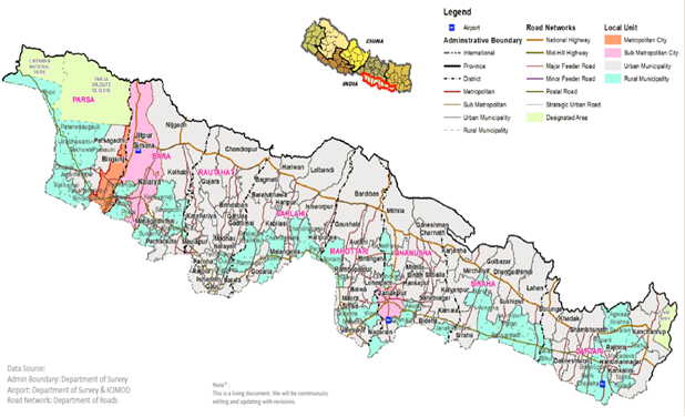
Strategic Road Network of Province-2 and Administrative division
Source: reliefweb.int
Distance Matrix (Province 2)
|
Distances from Province 2 Capital to Major Towns (km) |
||||||||
|---|---|---|---|---|---|---|---|---|
|
Janakpur |
Birgunj |
Kalaiva |
Gaur |
Malangawa |
Jaleshower |
Siraha |
Rajbira |
|
|
Janakpur |
|
157 |
143 |
136 |
91 |
20 |
83 |
120 |
|
Birgunj |
1.57 |
|
20 |
105 |
115 |
117 |
195 |
230 |
|
Kalaiva |
143 |
20 |
|
125 |
135 |
199 |
215 |
250 |
|
Gaur |
136 |
105 |
125 |
|
55 |
155 |
175 |
210 |
|
Malangawa |
91 |
115 |
135 |
55 |
|
45 |
130 |
165 |
|
Jaleshower |
20 |
117 |
199 |
155 |
45 |
|
90 |
125 |
|
Siraha |
83 |
195 |
215 |
175 |
130 |
90 |
|
82 |
|
Rajbiraj |
120 |
230 |
250 |
210 |
165 |
125 |
82 |
|
|
Distances from Province 2 Capital to Major Towns (hours) |
||||||||
|---|---|---|---|---|---|---|---|---|
|
Janakpur |
Birgunj |
Kalaiva |
Gaur |
Malangawa |
Jaleshower |
Siraha |
Rajbira |
|
|
Janakpur |
|
4 |
3.5 |
3 |
2 |
1 |
2 |
2.5 |
|
Birgunj |
4 |
|
0.5 |
2.5 |
3 |
4 |
4.5 |
5 |
|
Kalaiva |
3.5 |
0.5 |
|
3 |
3.5 |
4.5 |
5 |
5.5 |
|
Gaur |
3 |
2.5 |
3 |
|
1.5 |
2.5 |
3.5 |
4 |
|
Malangawa |
2 |
3 |
3.5 |
1.5 |
|
1 |
3 |
3.5 |
|
Jaleshower |
1 |
4 |
4.5 |
2.5 |
1 |
|
2 |
3 |
|
Siraha |
2 |
4.5 |
5 |
3.5 |
3 |
2 |
|
2 |
|
Rajbiraj |
2.5 |
5 |
5.5 |
4 |
3.5 |
3 |
2 |
|
Bagmati Province
All 13 districts of Bagmati Province are connected by roads. However, people living in the high altitude regions of Rasuwa, Sindhuplachok and Dolakha experience difficulty accessing roadways perennially. Major highways of the province are as follows:
- Tribhuvan Highway: Tribhuvan Highway (H02) which is also part of Asian Highway 42 (AH42) connects the capital city with Birgunj, a major business hub in Province 2 bordered with India.
- Araniko Highway: Araniko Highway (H03) which is also part of AH42 connects capital city with Kodari on the Nepal-China border.
- Prithivi Highway: Prithivi Highway (H04) connects capital city via Naubise, Dhading with Pokhara in Gandaki Province. This landslide-prone and heavily congested highway passes through five districts: Kathmandu, Dhading, Chitwan, Tanahuand Kaski.
- BP Koirala Highway: The BP Highway, also known as the Banepa- Bardibas Highway, links Kathmandu Valley with Province 2 and connects with eastern Nepal.
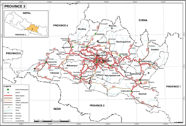
Road Network in Bagmati Province
|
Distances from Bagmati Province Capital City to Major Towns (km) |
|||||||
|---|---|---|---|---|---|---|---|
|
Hetauda |
Kathmandu |
Ratnanagar |
Bhimeshowr |
Bidur |
Dhunche |
Chautara |
|
|
Hetauda |
|
87 |
63 |
282 |
135 |
186 |
175 |
|
Kathmandu |
87 |
|
159 |
129 |
76 |
127 |
73 |
|
Ratnagar |
63 |
159 |
|
343 |
140 |
191 |
236 |
|
Bhimeshowr |
282 |
129 |
343 |
|
205 |
256 |
136 |
|
Bidur |
135 |
76 |
140 |
205 |
|
53 |
122 |
|
Dhunche |
186 |
127 |
191 |
256 |
53 |
|
204 |
|
Chautara |
175 |
73 |
236 |
136 |
122 |
204 |
|
|
Travel Time from Bagmati Province Capital City to Major Towns (hours) |
|||||||
|---|---|---|---|---|---|---|---|
|
Hetauda |
Kathmandu |
Ratnanagar |
Bhimeshowr |
Bidur |
Dhunche |
Chautara |
|
|
Hetauda |
|
3.50 |
1.25 |
7.50 |
5 |
7.25 |
7 |
|
Kathmandu |
3.50 |
|
4.25 |
4.75 |
2.50 |
4.75 |
3.75 |
|
Ratnagar |
1.25 |
4.25 |
|
8.75 |
3.75 |
6 |
8.25 |
|
Bhimeshowr |
7.50 |
4.75 |
8.75 |
|
7 |
9.25 |
5.50 |
|
Bidur |
5 |
2.50 |
3.75 |
7 |
|
2.50 |
6.25 |
|
Dhunche |
7.25 |
4.75 |
6 |
9.25 |
2.5 |
|
8.75 |
|
Chautara |
7 |
3.75 |
8.25 |
5.5 |
6.25 |
8.75 |
|
Gandaki Province
9 out of 11 districts of Gandaki Province are connected via blacktopped road. Road connection to Mustang and Manang although navigable are earthen and graveled and can pose serious issues during rainy season.
- Siddhartha Highway: Siddhartha Highway (H10) connects Province 5 to Gandaki Province. The highway starts at Nepal-India Border in Siddharthanagar and terminates at Prithivi chowk, Pokhara. The major settlements on the highway are Siddharthanagar, Butwal, Tansen, Waling, Putalibazar, Syangja and Pokhara.
Road Network in Gandaki Province
|
Distances from Gandaki Province Capital City to Major Towns (km) |
||||||||
|---|---|---|---|---|---|---|---|---|
|
Pokhara |
Vyas |
Gaindakot |
Baglung |
Gorkha |
Beshisahar |
Chame |
Jomsom |
|
|
Pokhara |
|
50 |
139 |
76 |
106 |
106 |
168 |
155 |
|
Vyas |
50 |
|
91 |
126 |
58 |
58 |
120 |
205 |
|
Gaindakot |
139 |
91 |
|
214 |
80 |
113 |
175 |
294 |
|
Baglung |
76 |
126 |
214 |
|
182 |
182 |
244 |
102 |
|
Gorkha |
106 |
58 |
80 |
182 |
|
81 |
143 |
262 |
|
Besisahar |
106 |
58 |
113 |
182 |
81 |
|
67 |
262 |
|
Chame |
168 |
120 |
175 |
244 |
143 |
67 |
|
323 |
|
Jomsom |
155 |
205 |
294 |
102 |
262 |
262 |
323 |
|
|
Travel Time from Gandaki Province Capital City to Major Towns (hours) |
||||||||
|---|---|---|---|---|---|---|---|---|
|
Pokhara |
Vyas |
Gaindakot |
Baglung |
Gorkha |
Beshisahar |
Chame |
Jomsom |
|
|
Pokhara |
|
1.50 |
4 |
2.75 |
2.75 |
3 |
6 |
6.75 |
|
Vyas |
1.5 |
|
2.75 |
4 |
1.50 |
1.75 |
4.75 |
8.25 |
|
Gaindakot |
4 |
2.75 |
|
6.50 |
2.50 |
3.50 |
6.50 |
10.75 |
|
Baglung |
2.75 |
4 |
6.50 |
|
5.25 |
5.75 |
8.75 |
5 |
|
Gorkha |
2.75 |
1.50 |
2.50 |
5.25 |
|
2.25 |
5.50 |
9.50 |
|
Besisahar |
3 |
1.75 |
3.50 |
5.75 |
2.25 |
|
3.50 |
10 |
|
Chame |
6 |
4.75 |
6.5 |
8.75 |
5.5 |
3.5 |
|
13 |
|
Jomsom |
6.75 |
8.25 |
10.75 |
5 |
9.5 |
10 |
13 |
|
Province 5
All 12 districts of Province 5 are connected via blacktopped road. Major highways of the province are as follows:
- Rapti Highway: Rapti Highway (H11) starts from Ameliya, Dang and terminates at Musikot West Rukum. This highway makes hilly regions of Rolpa, Salyan West Rukum and east Rukum accessible.
- Ratna Highway: Ratna Highway (H12) connects Province 5 to Karnali Province. It starts at Nepal- India border in Nepalgunj and terminates at Birendranagar, Surkhet. The highway transition into Karnali Highway system from the point it terminates.
- Mahendra highway: Mahendra highway traverses districts of Bardiya, Banke, Dang, Kapilvastu, Rupandehi, Parasi latitudinally. It connects Province 5 to Province 3 to east and Province 7 to the west.
Road Network in Province 5
|
Distances from Province 5 Capital City to Major Towns (km) |
|||||||
|---|---|---|---|---|---|---|---|
|
Butwal |
Ghorahi |
Nepalgunj |
Kapilvastu |
Rajapur |
Bhairahawa |
Ramgram |
|
|
Butwal |
|
148 |
249 |
49 |
266 |
29 |
41 |
|
Ghorahi |
148 |
|
153 |
120 |
169 |
161 |
188 |
|
Nepalgunj |
249 |
153 |
|
221 |
47 |
262 |
289 |
|
Kapivastu |
49 |
120 |
221 |
|
238 |
42 |
89 |
|
Rajapur |
266 |
169 |
47 |
238 |
|
279 |
306 |
|
Bhairahawa |
29 |
161 |
262 |
42 |
279 |
|
25 |
|
Ramgram |
41 |
188 |
289 |
89 |
306 |
25 |
|
|
Travel Time from Province 5 Capital City to Major Towns (hours) |
|||||||
|---|---|---|---|---|---|---|---|
|
Butwal |
Ghorahi |
Nepalgunj |
Kapilvastu |
Rajapur |
Bhairahawa |
Ramgram |
|
|
Butwal |
|
3.25 |
5 |
1 |
5.25 |
0.75 |
1 |
|
Ghorahi |
3.25 |
|
3 |
2.75 |
3.25 |
3.75 |
4.25 |
|
Nepalgunj |
5 |
3 |
|
4.25 |
1.25 |
5.50 |
5.75 |
|
Kapivastu |
1 |
2.75 |
4.25 |
|
4.75 |
1 |
2 |
|
Rajapur |
5.25 |
3.25 |
1.25 |
4.75 |
|
5.75 |
6 |
|
Bhairahawa |
0.75 |
3.75 |
5.50 |
1 |
5.75 |
|
0.75 |
|
Ramgram |
1 |
4.25 |
5.75 |
2 |
6 |
0.75 |
|
Karnali Province
The East-West Highway (EWH, 1,024 km) is the main traffic artery in the country but does not traverse Karnali province. The juncture with the EWH at Kohalpur along Ratna Rajmarg is 87 km away from Karnali Province’s capital, Birendranagar.
The last 40 km of the Ratna Highway from the border at Bheriganga Municipality, Surkhet with Bardiya district joins Province 5 with Karnali Province’s capital. The Karnali Highway (233km) traverses Surkhet, Dailekh, Kalikot, and Jumla crossing Mid Hill EW Highway at Sahijyula, Dailkeh. The Mid-hill EW highway which is 1,776 km long extending from Panchthar to Baitadi is the parallel highway which will provide an alternative to EW highway through hills. 278 km of Midhill highway traverses Dailekh (125 km), Jajarkot (83 km) and West Rukum (70 km) from Sahijyula, Dailekh to Ghorkhani in West Rukum. 176 km of Rapti Highway connects Salyan and West Rukum with EWH in Ameliya, Dang of that 124 km traverses Salyan and West Rukum from Salyan district border with Dang district till Musikot. At Musikot it meets Midhill EWH.
Road Network in Karnali Province
Distance Matrix (Karnali Province)
|
Distances from Karnali Province capital, Birendranagar to Major Towns (km) |
|||||||||||
|---|---|---|---|---|---|---|---|---|---|---|---|
|
|
Surkhet |
Chhinchu |
Dullu |
Dailekh |
Manma |
Nagma |
Jumla |
Gamgadhi |
Jajarkot |
Rukum |
Salyan |
|
Surkhet |
|
29 |
86 |
95 |
160 |
210 |
243 |
252 |
105 |
135 |
90 |
|
Chhinchu |
29 |
|
112 |
121 |
186 |
236 |
269 |
328 |
76 |
106 |
61 |
|
Dullu |
86 |
112 |
|
24 |
83 |
132 |
165 |
224 |
190.8 |
221 |
176 |
|
Dailekh |
95 |
121 |
24 |
|
107 |
172 |
205 |
264 |
200 |
230 |
185 |
|
Manma |
160 |
186 |
83 |
106.5 |
|
50 |
83 |
175 |
265 |
295 |
250 |
|
Nagma |
210 |
236 |
132 |
172 |
50 |
|
33 |
92 |
315 |
345 |
300 |
|
Jumla |
243 |
269 |
165 |
205 |
83 |
33 |
|
125 |
348 |
378 |
333 |
|
Gamgadhi |
252 |
328 |
224 |
264 |
175 |
92 |
125 |
|
407 |
437 |
392 |
|
Jajarkot |
105 |
76 |
191 |
200 |
265 |
315 |
348 |
407 |
|
60 |
105 |
|
Rukum |
135 |
106 |
221 |
230 |
295 |
345 |
378 |
437 |
60 |
|
45 |
|
Salyan |
90 |
61 |
176 |
185 |
250 |
300 |
333 |
392 |
105 |
45 |
|
|
Travel Time from Birendranagar, Surkhet to Major Towns (hours) |
|||||||||||
|---|---|---|---|---|---|---|---|---|---|---|---|
|
|
Surkhet |
Chhinchu |
Dullu |
Dailekh |
Manma |
Nagma |
Jumla |
Gamgadhi |
Jajarkot |
Rukum |
Salyan |
|
Surkhet |
|
1.25 |
4 |
4.5 |
6.5 |
7.75 |
9 |
14.25 |
5.5 |
6.75 |
3.75 |
|
Chhinchu |
1.25 |
|
5.5 |
5 |
7.75 |
9 |
10.25 |
15.50 |
4 |
5.5 |
2.5 |
|
Dullu |
4 |
5.5 |
|
2 |
4.5 |
7 |
6.5 |
13.5 |
9.5 |
10.75 |
7.75 |
|
Dailekh |
4.5 |
5 |
2 |
|
5.5 |
7 |
8 |
11 |
10 |
11.25 |
8 |
|
Manma |
6.5 |
7.75 |
4.5 |
5.5 |
|
2.5 |
3.5 |
8 |
12 |
13.25 |
10.25 |
|
Nagma |
7.75 |
9 |
7 |
7 |
2.5 |
|
1.5 |
6.5 |
13.25 |
14.5 |
11.5 |
|
Jumla |
9 |
10.25 |
6.5 |
8 |
3.5 |
1.5 |
|
8 |
14.5 |
15.75 |
12.75 |
|
Gamgadhi |
14.25 |
15.50 |
13.5 |
11 |
8 |
6.5 |
8 |
|
19.75 |
21 |
18 |
|
Jajarkot |
5.5 |
4 |
9.5 |
10 |
12 |
13.25 |
14.5 |
19.75 |
|
6 |
9 |
|
Rukum |
6.75 |
5.5 |
10.75 |
11.25 |
13.25 |
14.5 |
15.75 |
21 |
6 |
|
3 |
|
Salyan |
3.75 |
2.5 |
7.75 |
8 |
10.25 |
11.5 |
12.75 |
18 |
9 |
3 |
|
Known obstacles and bridges in Karnali province
Construction of Bridge on Karnali Highway on the way to Manma.
Construction of bridges on the lengths of highways could delay the movement but are not a hindrance. Numerous bridges are being constructed.
The district of Humla is not yet connected with road network. A project to link the Humla with Karnali Highway is under progress in Kalikot district. A special travel arrangement could be made in the form of the ferry to carry vehicles across the Karnali river but that is not possible during the rainy season.
Dolpa is also not accessible through a connecting road. The government is attempting to link the roadway to Dolpa, Dunai. The road is linked to Rukum, Jajarkot districts. The road is 118 km long, of which 73 km road construction has been completed.
Sudurpashchim Province
The East-West highway is the lifeline to all 9 districts in Sudurpashchim Province. The road networks joining province capitals Kailali and district headquarter, Kanchanpur, south of the East-West highway and other seven districts headquarter with north of East-west highway are accessible but the problem of inundation in Terai and frequent landslide often pose severe access constraints during the monsoon season. Puspalal Mid hill Highways is in the construction process but at a slow pace.
Strategic Road Network of Sudurpaschim Province
Source: Road Network Data (DoR)
Distance Matrix (Sudurpashchim Province)
|
Distances from Sudurpaschim Province capital, Dhangadi to Major Towns (km) |
|||||||||
|---|---|---|---|---|---|---|---|---|---|
|
Kailali |
Kanchanpur |
Dadeldhura |
Baitadi |
Darchula |
Bajhang |
Doti |
Bajura |
Achham |
|
|
Kailali |
|
64 |
155 |
182 |
328 |
280 |
200 |
340 |
306 |
|
Kanchanpur |
64 |
|
203 |
221 |
368 |
320 |
240 |
380 |
346 |
|
Dadeldhura |
155 |
203 |
|
37 |
174 |
116 |
45 |
185 |
151 |
|
Baitadi |
182 |
221 |
37 |
|
157 |
102 |
71 |
221 |
177 |
|
Darchula |
328 |
368 |
174 |
157 |
|
249 |
281 |
358 |
324 |
|
Bajhang |
280 |
320 |
116 |
102 |
249 |
|
161 |
301 |
267 |
|
Doti |
200 |
240 |
45 |
71 |
281 |
161 |
|
140 |
106 |
|
Bajura |
340 |
380 |
185 |
221 |
358 |
301 |
140 |
|
52 |
|
Achham |
306 |
346 |
151 |
177 |
324 |
267 |
106 |
52 |
|
|
Distances from Sudurpaschim Province capital, Dhangadi to Major Towns (km) |
|||||||||
|---|---|---|---|---|---|---|---|---|---|
|
Kailali |
Kanchanpur |
Dadeldhura |
Baitadi |
Darchula |
Bajhang |
Doti |
Bajura |
Achham |
|
|
Kailali |
|
2 |
5 |
7 |
10 |
9 |
7 |
12 |
10 |
|
Kanchanpur |
2 |
|
7 |
7 |
12 |
11 |
8 |
13 |
12 |
|
Dadeldhura |
5 |
7 |
|
2 |
6 |
4 |
2 |
7 |
6 |
|
Baitadi |
7 |
7 |
2 |
|
5 |
4 |
3 |
8 |
7 |
|
Darchula |
10 |
12 |
6 |
5 |
|
9 |
10 |
12 |
11 |
|
Bajhang |
9 |
11 |
4 |
4 |
9 |
|
6 |
10 |
9 |
|
Doti |
7 |
8 |
2 |
3 |
10 |
6 |
|
5 |
4 |
|
Bajura |
12 |
13 |
7 |
8 |
12 |
10 |
5 |
|
2 |
|
Achham |
10 |
12 |
6 |
7 |
11 |
9 |
4 |
2 |
|
Known obstacles and bridges in Sudurpashchim province
Rocky section of F154 in Bumramadichaur joining Nagma to Gamgadhi, Mugu
The SRN connecting districts of Karnali Province are relatively unobstructed by landslides. But numerous bridge building activities have diverted roads into small rivulets, which can delay traffic and can be temporarily obstructed during the monsoon season.
Landslide and flood-prone area in a different location throughout the Sudurpashchim province
|
Address |
GR/Map sheet |
Latitude |
Longitude |
Hazard and Risk |
Remark |
|---|---|---|---|---|---|
|
Kakada |
46709130 |
N29° 47'08'' |
E80° 26'09'' |
Landslide |
Mahakali highway |
|
Kimtadi |
53559990 |
N29° 49'32'' |
E80° 30'07'' |
Landslide |
Mahakali highway |
|
Khaulchaura |
46879012 |
N29° 44'01'' |
E80° 27'05'' |
Landslide |
Mahakali highway |
|
Terselake |
50759012 |
N29° 44'20'' |
E80° 29'09'' |
Landslide |
Mahakali highway |
|
Dudhali Gard |
52578957 |
N29° 46'28'' |
E80° 30'48'' |
Landslide |
Mahakali highway |
|
Baitadi |
NA |
N29° 39'158'' |
E80° 31'229'' |
Landslide |
Baitadi Road |
|
Baitadi -Bangabagar |
NA |
N29. 664634' |
E80.545070' |
Flash flood |
Mahakali Highway |
|
Bajura-Dwari, Kailashmandu |
NA |
N 29.399555 |
E81.393506 |
Landslide |
Bajura Road |
|
Lalmatiya Bhaluwang- Dang |
NA |
N27.837510 |
E82.763178 |
Road damage- east-west highway |
Due to irrigation project |
