Ecuador - 1.1 Humanitarian Background
Disasters, Conflicts and Migration
Ecuador is exposed to extreme weather conditions and frequent natural hazards such as earthquakes, floods, tsunamis and volcanic eruptions that affect both local populations and migrants living in the country. Ecuador is also located in an area of intense seismic activity and, in 2016, Ecuador was hit by an earthquake that affected the coastal areas of the provinces of Manabí and Esmeraldas, killing 670 people and leaving more than 30,000 people homeless. In addition to the aforementioned, Ecuador is regularly affected by El Niño, the consequences are major floods and landslides in several areas of the country. Currently, Ecuador is facing heavy rains that are affecting cities in different regions of the country.
The wet season (high temperatures and abundant rain) is recorded between December and April-May due to the presence of the warm El Niño current and the Intertropical Convergence Zone. The dry season, characterized by low temperatures and little rain, lasts from June to November or December
There is a weak culture of risk prevention in the country, so many people do not know how to act if a disaster occurs; Therefore, the development of capacities in aspects related to the prevention and response to natural disasters is imperative in Ecuador.
Floods and earthquakes have caused the greatest socioeconomic impact and human losses in the country. The most recurring threats in the territory are: floods and landslides in winter while forest fires are recorded in summer.
Source: Global Crisis Response Platform Humanitarian and Crisis Transition Activities. https://crisisresponse.iom.int/response/ecuador-crisis-response-plan-2020
El Niño Phenomenon 2023-2024, El Niño Southern Oscillation (ENSO)
According to the authorities, the El Niño phenomenon is expected to settle on the coasts of Ecuador in the last quarter of 2023, starting in October or November. For now, the probability that the event will occur on these dates is 84%. In Ecuador, El Niño would affect almost the entire country, but mainly the provinces in the coastal zone: Esmeraldas, Manabí, Los Ríos, Guayas and El Oro.
Fenómeno El Niño Ecuador 2023-2024 El Niño Oscilación Sur (ENOS)
Among the most important actions included in the plan are: identifying existing capacities and gaps in preparation and response actions; validate institutional plans; demonstrate the articulation and flow of information between the different State institutions, and finally verify the application of the national and international humanitarian assistance mechanisms, their protocols, procedures, operational and administrative management. All these aspects will allow analysis and decision-making in the different phases of: prevention, mitigation, preparation, response and reconstruction on a national scale.
Sendai Framework for Disaster Risk Reduction 2015-2030
Ecuador adopted the Sendai Framework for Disaster Risk Reduction 2015-2030* and is firmly committed to its application, as a guide to improve all efforts for the future.
It is a planning instrument with a short, medium and long-term perspective, to guide State actions at all levels, through the actors of the National Decentralized Risk Management System.
This new, far-reaching post 2015 – 2030 framework for disaster risk reduction contains seven goals and four priorities for action.
1: Understanding disaster risk,
2: Strengthen disaster risk governance to manage disaster risk,
3: Invest in disaster risk reduction for resilience,
4: Strengthen disaster preparedness for effective response and to “Build Back Better” in recovery, rehabilitation and reconstruction.
United Nations Office for Disaster Risk Reduction www.unisdr.org
(*) https://www.eird.org/americas/docs/43291_spanishsendaiframeworkfordisasterri.pdf
Security, Current Situation in Ecuador
Ecuador's geographical location and other environmental characteristics have long provided incentives for transnational organized crime, which takes advantage of the country as a narcotics transshipment point and as a logistical refuge. The diverse transnational criminal landscape in Ecuador, dominated by South American insurgent and criminal groups, in addition to drug cartels, has made it a growing focus of organized crime.
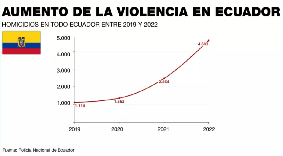
The different criminal gangs in the country have become more sophisticated and organized. They have gained control over a wide range of criminal economies, including micro-trafficking. The gangs control many of the country's prisons and have strengthened connections with major international criminal organizations, acting as intermediaries through Ecuador's huge ports to Europe, the United States and even Australia.
|
Natural Disasters |
||
|---|---|---|
|
Type |
Occurs |
Comments / Details |
|
Drought |
Yes, from June to December |
Yes, from June to December Droughts constitute one of the dangerous events that has become more severe and recurrent in recent years, causing important impacts mainly for the agricultural and livestock sector, with consequences of low agricultural production, population migration to urban areas. , increase in forest fires due to prolonged periods of lack of rain. |
|
Earthquakes |
Yes |
Ecuador is subject to intense and continuous geological activity due to its proximity to several geological faults created by the movements of the Nazca and South American Continental oceanic tectonic plates, which generates a constant threat of earthquakes of various magnitudes. Earthquakes occur frequently, although many are not felt. Generally, there are between 100 and 200 notable earthquakes (4 and above on the Richter scale) per year throughout Ecuador and most occur in coastal regions. |
|
Epidemics |
Yes |
Covid 19 consulte: Información interactiva sobre la respuesta operativa del Equipo Humanitario País en Ecuador.
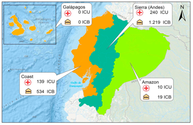
ICUs and beds in Ecuador national health system Courtesy of Pablo Galarza, United Nations Office for the Coordination of Humanitarian Affairs (OCHA)
HIV/AIDS in Ecuador, see the UNAIDS website: : ONU SIDA In the country, endemic diseases are reported that have caused health crises or that in disasters, have occurred as a side effect, aggravating the conditions of humanitarian assistance. Between that stand out: • Dengue • Zika • Malaria • Measles (2011) • A H1N1 • Leptospirosis There have also been focused crises of meningitis, EDA and ARI; as well as regional crises among others. Dengue In 2019-2020, a large dengue epidemic occurred in Guayaquil, Ecuador; The CDC estimated that at least 420,000 people were infected during the epidemic, but there were very few deaths. The 2019-2020 period includes a new increase in cases and one of the largest dengue outbreaks in the region with nearly 3 million cases, 8,416 of them in Ecuador. Chikungunya In Ecuador, Chikungunya was reported for the first time at the end of 2014 and now both arboviral diseases are public health priorities mainly in five locations in 4 provinces: Esmeraldas, Guayas, El Oro and Galapagos (Santa Cruz and San Cristóbal). Cholera In 1991, the first wave of cholera (seventh pandemic on the South Pacific coast) was characterized by a very high attack rate and a low mortality rate (compared to Africa), and the unexpected participation of populations living in the Andean plateau. It is probable, based on the results collected in Ecuador, that cholera will become endemic in Latin America. The 1991 cholera epidemic affected 46,320 people and killed 565. Aphtose fever A large-scale foot-and-mouth disease epidemic on an unprecedented scale swept through Ecuador's countryside in 2002, affecting cattle, pigs, sheep and goats. |
|
Extreme Temperatures |
Yes |
El fenómeno climático de El Niño expone zonas del Ecuador a los riesgos del cambio climático. Estos cambios han provocado temperaturas extremadamente frías en Carchi, Cotopaxi, Chimborazo, Cañar y Azuay, y han resultado en un clima más cálido en todas las demás partes del Ecuador. |
|
Flooding |
Yes |
In Ecuador, floods are part of the dynamics of hydrographic basins. Due to El Niño from March 1972 to February 1973, the provinces of Guayas, Esmeraldas and Los Ríos, and from August 1982 to November 1983 in the provinces of Manabí, Guayas, El Oro and Los Ríos, were severely impacted by The phenomenon. , which represented 15% of the national coastal territory. The El Niño phenomenon from October 1997 to June 1998 severely impacted the provinces of Guayas, Manabí, Esmeraldas, El Oro, Los Ríos, Chimborazo, Azuay and Cañar, affecting 10% of the gross domestic product (GDP). ) national. Floods are being recorded not only in the coastal area but also in the Andean mountain range.
Estimated Floods due to the El Niño Southern Oscillation “ENSO” Phenomenon 2023, see Annex B page. 34: https://www.gestionderiesgos.gob.ec/wp-content/uploads/2023/08/Plan-para-enfrentar-el-ENOS-01-08-2023-compressed.pdf |
|
Insect Infestation |
Yes |
Aedes aegypti reported in five locations in 4 provinces of Ecuador: Esmeraldas, Guayas, El Oro and Galápagos (Santa Cruz and San Cristóbal).
“Grylloidea” crickets were observed in 2020 in Guayas in notable volumes. Crickets proliferate due to climatic conditions, in this case, the rains in the coastal area of Ecuador. It is considered a winter pest and does not bite or transmit viruses or diseases with the sole exception of food being contaminated by the excrement and fragments of this animal. |
|
Mudslides |
Yes, from December to June |
The most vulnerable areas are the provinces of Morona Santiago, Loja, Napo, Santo Domingo de los Tsáchilas and Orellana El Oro. Many main roads linking these provinces are affected by landslides. |
|
Volcanic Eruptions |
Yes |
With 84 volcanoes, of which 24 are active, Ecuador is located in a subduction zone between the Nazca and South American tectonic plates that cause intense seismic activity, which is why it forms the Pacific Ring of Fire. In addition, the active geological faults expose the population to a high vulnerability due to volcanic and seismic risk |
|
High Waves / Surges |
Si |
Tsunami occur rarely in Ecuador. There have only been 4 tsunamis since 1906 and a total of 4 people have died as a result. Although Tsunami are not recorded frequently (last 500 years), it is one of the phenomena that could have the greatest impact along the Ecuadorian coastal profile because more than 50% of the population of coastal cities and settlements are located. in high exposure areas. |
|
Wildfires |
Yes, From June to December |
En el Ecuador, desde el año 2010 al 2022 se registraron 22.022 incendios forestales que han causado la pérdida de más de 213.157,23 mil hectáreas de páramos, bosques secos y montanos, entre otros. En lo que va del año, hasta este 20 de agosto, se han registrado un total de 664,83 ha. de vegetación afectada por incendios forestales en Azuay y en Cañar se han afectado un total de 70,47 ha. |
|
High Winds |
||
|
Other Comments |
UN, (Naciones Unidas). (2019). Objetivos de Desarrollo Sostenible 2030. https://www.un.org/sustainabledevelopment/es/objetivos-de-desarrollo-sostenible/ UNDRR, (UN Office for Disaster Risk Reduction). (2015). Marco de Sendai. https://www.undrr.org/publication/sendai-framework-disaster-risk-reduction-2015-2030 |
|
|
Man-Made Issues |
||
|
Civil Strife |
No |
|
|
International Conflict |
No |
|
|
Internal Conflict |
Yes |
Estado de Emergencia y conflicto interno del Ecuador In January 2024, President Daniel Noboa declared a state of emergency and internal conflict in Ecuador, in order to put an end to the insecurity that remains of great concern to the civilian population. The decree of state of internal armed conflict allows the joint action of the military and police both in the streets and in prisons, controlled by criminal gangs, to this end, the President orders the mobilization and intervention of the Armed Forces and National Police in the national territory to guarantee sovereignty and territorial integrity against transnational organized crime, terrorist organizations and belligerent non-state actors. The Decree orders the Armed Forces to carry out military operations, under international humanitarian law and respecting rights, to neutralize the groups identified therein.
Decreto de Estado de Excepción The Constitutional Court of Ecuador unanimously declared on 03/01/2024 the legal validity of the state of emergency decreed by President Daniel Noboa to confront organized crime, after the wave of violence and attacks by criminal gangs that occurred at the beginning of January
On April 21, 2024, Ecuador will return to the polls to say 'yes' or 'no' to the questions of the popular consultation and referendum promoted by the President, in addition to a constitutional amendment question. Voters will decide on issues such as: the participation of the military in arms control, the increase in penalties for crimes linked to organized crime and the possibility of public forces using weapons seized from criminals. Other proposals from the Executive are to allow the extradition of Ecuadorians, recognize international arbitration in commercial disputes and allow hourly work.
|
|
Internally Displaced Persons |
No |
|
|
Migrants |
Sociopolitical problems in Venezuela have caused migration to Ecuador. In September 2019, approximately 4.3 million people left Venezuela. 80 percent emigrated to Latin America and the main receiving countries have been Colombia, Peru and Ecuador. At the beginning of the Venezuelan exodus, Ecuador was characterized as a transit country to Peru or other countries in the southern cone such as Chile and Argentina. However, between 2015 and September 2019, almost 400,000 Venezuelans decided to settle in the country. With almost half a million Venezuelan nationals, Ecuador is home to the third largest population of migrants from that country in the world, after Colombia and Peru. The majority of these migrants do not have adequate documentation. Many are transients heading to other South American nations, such as Peru and Chile. |
|
|
Landmines / UXO Present |
No |
|
|
Other Comments |
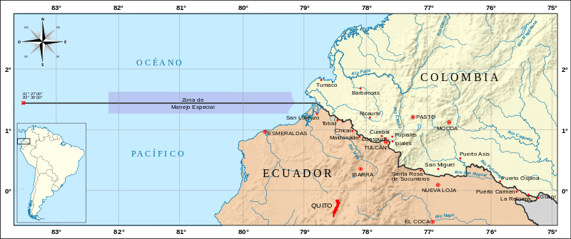
The Ecuador-Colombia land border has a length of close to 586 kilometers3. The demobilized Revolutionary Armed Forces of Colombia (FARC) had a long presence in the country, dedicated to the production of narcotics and illegal mining along the border, although some factions of the ex-FARC guerrilla—dissidents of the first group—are still present in the territory.
https://it.m.wikipedia.org/wiki/File:Mapa_de_la_frontera_Colombia-Ecuador.svg
(3) The border between Colombia and Ecuador is an international boundary that separates the territories of both countries. It consists of two sections, one land and the other maritime, well defined
|
|
|
|
|
|
For a more detailed database on disasters by country, please see the Centre for Research on Epidemiology of Disasters Country Profile. https://www.emdat.be/
Seasonal Effects on Logistics Capacities
|
Seasonal Effects on Transport |
||
|---|---|---|
|
Transport Type |
Time Frame |
Comments / Details |
|
Primary Road Transport |
Seasonal changes occur in two periods:
Rainy season from December to June. Dry season from June to December. |
In the rainy season, landslides and obstructions affect both primary and secondary roads. Cleaning roads usually takes considerable time. Landslides blocking roads cause shortages of local products in local markets and, in turn, can cause food prices to rise. Although the seasons can vary constantly in Ecuador, periods of rain generate problems of landslides, floods and closures, also due to the poor state of the infrastructure. |
|
Secondary Road Transport |
Temporada de lluvias de diciembre a junio. Temporada seca de junio a diciembre. |
Same as the main road but the effects on secondary roads are significantly bigger. |
|
Rail Transport |
The biggest challenge present in Ecuador is the amount of rain in certain seasons of the year, so retaining walls are essential to control that these rains do not cause landslides or collapses on the railway tracks. With 4 regions: coast, mountains, east and island, these regions are separated by mountains, which makes road communication between these regions difficult, it also has a large number of rivers, streams, so adequate maintenance, prevention and rapid debris removal reaction is essential. of the railway in these sections. |
|
|
Air Transport |
Airport operations can be affected by ash from volcanic eruptions and earthquakes. Due to the climatic variation in the country, the probability of changes in weather, wind direction, speed, visibility, weather events such as fog, haze, thunderstorms, heavy rain, temperature and atmospheric pressure is high.
Flooded trails, poor drainage networks and fog obstruct the visibility of the limited signage.
In such circumstances, infrequently used airports and military airports will be used for domestic or international air operations. |
|
|
Waterway Transport |
Seasonal changes occur in two periods: • Rainy from December to June known as "Winter" or rainy season. "Summer" or dry season, with less rainfall that extends from June to December |
Lower water levels affect transportation on major waterways. During the dry season: sedimentation, sharp rocks and low channels affect the service. The high rainfall generated an uncontrolled riverbed, which does not allow adequate navigation. |
|
Seasonal Effects on Storage and Handling |
||
|---|---|---|
|
Activity Type |
Time Frame |
Comments / Details |
|
Storage |
From October to April |
The biggest problem is the effect of the rainy season on the roads that provide access to the warehouses. Additionally, some roofs of government warehouses are negatively affected by rains. The government has warehouses in some strategic locations, from where humanitarian aid items can be distributed to support local emergencies. |
|
Handling |
N/A |
|
|
Other |
N/A |
The wet season (high temperatures and abundant rain) is recorded between December and April-May due to the presence of the warm El Niño current and the Intertropical Convergence Zone. The dry season, characterized by low temperatures and little rain, lasts from June to November or December |
Capacity and Contacts for In-Country Emergency Response
GOVERNMENT
Based on the Ecuadorian Constitution of 2008, the Government of Ecuador assumed leadership in emergency preparedness and response actions, reorganizing what until then was known as Civil Defense, and creating a new organization: the Risk Management Secretariat ( SGR) Gestión de Riesgos In a joint effort with provincial governments, the SGR became the organization responsible for developing a Decentralized National Risk Management System (SNDGR), supporting people and communities that are negatively affected by natural and/or disasters caused by the man. The SGR is responsible for establishing policies and directives to ensure a coordinated Emergency Preparedness and Response (EPR) system by promoting the development and improvement of capabilities aimed at: 1) identifying, preventing and mitigating risks; 2) respond and assist during emergency situations; 3) apply recovery and reconstruction actions after the occurrence of a disaster.
Risk management is part of the general security of the country and is the direct responsibility of each public and private sector entity within its geographical scope; Risk management will operate continuously as a normal part of planning and management. The risks will be managed under the principle of subsidiary decentralization, which will imply direct responsibility of the institutions within their geographical scope. When an entity's risk management capabilities are insufficient, other territories with greater financial and technical capacity can provide the necessary support, without being relieved of their own responsibilities. The general objective, mandated by the Constitution, is to minimize vulnerability.
The SNDGR is made up of the governing body; the risk management units of all public and private entities at the local, regional and national level; scientific entities that study threats and vulnerabilities; and coordination mechanisms, among others. All state ministries and UN agencies present in Ecuador are part of the SNDGR.
The Emergency Operations Committees Manual (COE) Manual del COE establishes that the Armed Forces are part of the Operational Group responsible for logistical support (in addition to managing external security).
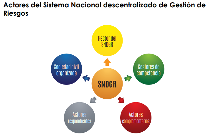
Source: National Risk and Emergency Management Service. Actors of the National Decentralized Risk Management System.
For more information on government contact details, please see the following link: 4.1 Government Contact List.
HUMANITARIAN COMMUNITY
Ecuador has had a Humanitarian Country Team (EHP) since 2014, whose leader is the Resident Coordinator. The EHP is assisted by UN agencies, national and international humanitarian organizations and donors. The EHP supported Ecuador in the April 16 earthquake, including in the activation and organization of emergency groups. The Logistics Cluster was active during the emergency until May 30.
The Ecuadorian Red Cross is present throughout the country. Many NGOs are present at the local level and work directly with communities on preparedness, development and protection.
For more information on humanitarian agency contact details, please see the following link: 4.2 Humanitarian Agency Contact List.
|
Ecuador - Ministries and UN Agencies Liaison |
||
|---|---|---|
|
Sector |
Ministry |
UN Agency |
|
Agriculture and Food Security |
Ministry of Agriculture and Livestock
Ministry of Economy and Social Inclusion
Risk Management Secretariat |
FAO, WFP |
|
Health, Nutrition |
Ministry of Public Health |
PAHO UNICEF |
|
Education |
Ministry of Education |
UNICEF |
|
Potable Water |
Ministry of Public Health National Water Secretariat |
UNICEF |
|
Transport Logistics and Communications |
Ministry of Defence |
WFP |
|
Protection of Women & Children |
Ministry of Justice |
IOM, FICR |
|
Coordination and Evaluation |
Risk Management Secretariat |
OCHA |