2.3 Afghanistan Road Network
Overview
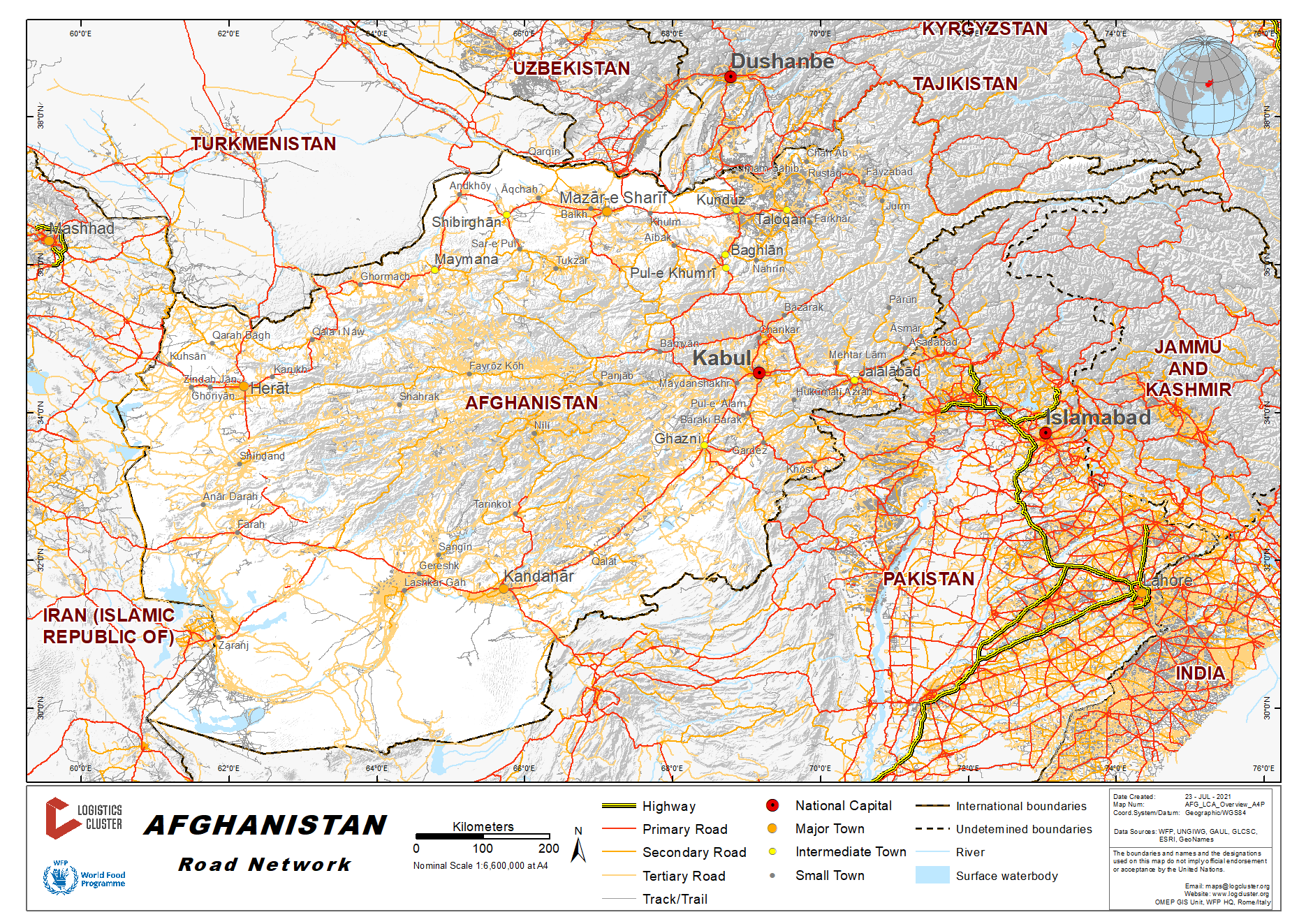

The Ministry of Public Works (MPW) and Ministry of Rural Rehabilitation and Development (MRRD) are generally responsible for development, management and maintenance of Afghanistan roads.
|
Road Classification |
Length (km) |
|---|---|
|
National Highways |
3,363 km |
|
Regional Highways |
4,884 km |
|
Provincial Roads |
9,656 km |
|
Rural Roads (unpaved) |
17,000 km |
As a result of decades of conflict, the road network was largely
destroyed. Since 2002, Afghanistan has launched major programmes
for improving its road network with the help of various
international partners: the National Emergency Rural Access Project
(NERAP) and National Rural Access Programme (NRAP) among
others.
Highway 1 or A01, formally called the Ring Road, is a 2,200 kilometre two-lane road network circulating inside Afghanistan connecting the following major cities (clockwise): Mazar, Kabul, Ghazni, Kandahar, Farah and Herat. It has extensions that also connect Jalalabad, Lashjkar Gah, Delaram, Islam Qala and several other cities. It is part of AH1, the longest route of the Asian Highway Network.
Part of Highway 1 has been refurbished since late 2003, particularly the Kabul-Kandahar, with funds provided by the USA, KSA and others. Most work on that stretch was done by Turkish, Indian and local companies. Japanese companies were also involved near the southern Afghan province of Kandahar. In the west, Iran participated in the two-lane road construction between Islam Qala and the western Afghan city of Herat. Pakistan rebuilt the Jalalabad – Kabul road.
Road Security
|
Road Security Issue |
Comments |
|---|---|
|
Mines |
Vehicles face the potential danger of encountering land mines that may have been planted on or near roadways. Land mines, large quantities of unexploded ordnance and insurgents exist throughout the countryside and alongside roads, posing a danger to travelers. |
|
Crimes |
Robbery and kidnappings, are a potential hazard on highways outside main cities. |
|
General Road Safety |
The transportation system in Afghanistan is marginal. Vehicles are poorly maintained, often overloaded, and traffic laws are not enforced. Vehicular traffic is chaotic and must contend with numerous pedestrians, bicyclists, and animals. Many urban streets have large potholes and are not well lit. Rural roads are not paved. With congested roads and abundant pedestrian traffic, vehicle accidents are a serious concern and can escalate into violent confrontations. |
|
Commercial Transport Availability |
Commercial transporters sometimes decline to provide services to insecure areas. |
Weighbridges and Axle Load Limits
The newly built highways are constructed according to the norm and standards of vehicles’ capacity. Their axial contain four wheel tires and each axial is computed as (12) tons. Those axial with their own weights containing two tires are evaluated and practiced as (6) tons which means each tire has the capacity of (3) tons.
Road Class and Surface Conditions
Generally, road transport is the major means of transportation in Afghanistan. Roads are very important in a country like Afghanistan, which is landlocked and does not have adequate marine, air and rail transport. Majority of the roads in the Southern Region of Afghanistan were destroyed during the prolonged civil war. Some new roads were constructed and the old ones were reconstructed. Blockages caused by security are to be considered.
Afghanistan Road Network Regional Information
|
Region |
Comments |
Seasonal Constraints |
|---|---|---|
|
Southwestern Region - Kandahar Province |
The road condition to all districts is generally good during the dry season. |
During the summer season the road condition to all the provinces is generally good. However, in winter and spring seasons some provinces are blocked because of snowfall, heavy rain and flooding. Road to all districts in Kandahar province are generally good during the dry season while in rainy season the roads to Nesh, Maineshin, Ghorak, Maruf, Shorawak, and Reg districts become impassable. |
|
Southwestern Region - Uruzgan Province |
Mountainous area characterized by steep and narrow roads that makes transportation very difficult in winter especially to districts like, Gezab, Khas-Uruzgan, Dehrawad, Chinarto, Char-Chino and Chora. |
Khas-Uruzgan is one of the worst heavy snowfall affected areas but can be accessed with smaller trucks but prolonged delays can be expected. |
|
Southwestern Region - Nimroz Province |
Plain land, mostly dusty and sandy and the road from Dilaram to Zaranj City is asphalted. The roads to other FDPs in the province are not paved, but they are generally good in summer. |
During March, April and May water level increases in Helmand River result in trucks being unable to cross Sarshila (the crossing point on the river to Kang district) of Nimroz province. However, cargo and truck may be loaded on a Ferry in order to cross the river and then continue the trip to the final destination in Kang district centre. |
|
Southwestern Region - Hilmand Province |
Roads are mostly graveled and compacted, while still some areas have very sandy and unpaved roads that are passable only with small vehicles such as Garamser district. |
Most roads to districts in Hilmand Province are passable throughout the year except few districts like Musa-qala, Baghran, Nawzad, Washir, Deshoo and Khanashin, which are not accessible in the rainy season. |
|
Southwestern Region - Zabul Province |
Mountainous area and it is not easy for transportation except for Qalat (the capital city of Zabul) and Shar-i-safa District and Shahjoy, which are located on the main Kandahar-Kabul highway. |
Zabul Province is usually badly affected by the heavy snow fall in the winter. The road condition during dry season is good in all districts, whereas the roads to Arghnadab, Daychoopan, Nwabahar, Shinkay, Shamalzai and Atghar districts are impassable in the rainy season. |
|
Eastern Region |
Roads in Nuristan and Kunar provinces are mostly in the mountains area, however, roads in Nangarhar and Laghman provinces are not mountainous except 2-3 districts. Roads to district centres are mostly paved but roads leading to villages are not paved with some that are very narrow making transport very difficult. At some areas, trucks should be loaded less than their capacity to be able to cross the bridges or go up to the hills. Transportation of goods to Nuristan and some other villages in eastern region requires secondary transportation as trucks cannot pass the narrow and unpaved roads. As a result, there is specific type of vehicles for specific routes to fulfil the market requirement. |
Transport capacity in the Eastern Region is hardly affected by the seasons, particularly because; most of the commodities grown in the region are consumed locally (i.e. fruits, vegetables) and not transported to other parts of the country. In eastern region, heavy snowfall is not common but rainfall is quite natural. During the winter period (December – February) effects are seen on transportation of commodities to some parts of Laghman, Kunar, & Nuristan provinces where areas prone to flood, rock falls, snow, become hardly accessible by road. For Nuristan province in particular, the roads are usually accessed by smaller vehicles (pick-ups) but become hardly accessible in the winter when the roads become muddy. Roads temporarily get blocked by landslide or rock fall, people will clean the road with support of government. |
|
Northern Region |
The main roads in the region are narrow. There is only one main tarmac road connecting Kabul with Maimana through Mazar with junction to Hairaton (northern border). Mazar City to Hairaton District-Uzbekistan Border (86 kms) The road from Mazar to Hairaton is asphalt road. This road is passable to all kind of trucks with different tonnage capacity. This road is the main transit road to cargo from Uzbekistan to Afghanistan. Mazar City to Shiberghan-Jawzjan province (136kms) The road from Mazar to Shiberghan is asphalted road. This is the only road connecting Mazar to Faryab and Sar I Pul through Shiberghan. This road can be travelled by all kind of trucks. Through this road, several districts like Balkh, Charbolak, Aqcha,Faizabad and many more are connected to each other. Shiberghan to Ankhoi/Aqina (110 kms) The road from Shiberghan to Andkhoi is asphalted. This road can be travelled by any type of vehicle with some seasonal restrictions. The road from Andkhoi to Aqina (northern border) is usually muddy and bumpy. Andkhoi to Maimana city-Faryab (81 kms) Road is asphalted and passable by all types of vehicles throughout the year. Mazar City to Samangan-Aybak District (135 kms) The road to Samangan is passing the Khulm Valley and the condition of this road is good and passable throughout the year for all kind of trucks with different capacities. This road is the highway connecting the Northern region to Kabul. Mazar City to Kabul (425 kms) This is the asphalted highway connecting the Northern Region and the capital Kabul and central Afghanistan. The road is passable throughout the year when snowfall does not block the Salang tunnel. |
In general, transportation in Northern provinces is mostly hindered due to heavy winter especially in those places where snowfall and rain start early. In areas prone to landslide and flooding, delivery may be delayed due to temporary road blocks. There are some remote areas like Lawlash and Bandar of Faryab province, Cheras of SAR I Pul province where there is no means of access once the snow starts to fall. It is therefore necessary to pre-position required stocks in these districts prior to commencement of winter. Mazar City to Shiberghan-Jawzjan province (136kms) The small roads to the villages are muddy/hilly and bumpy. Most of them are impassable during the winter time. Shiberghan to Ankhoi/Aqina (110 kms) Roads from Andkhoi to Aqina border is muddy and bumpy and during the rainy weather it is hardly passable. Mazar to kabul The Salang pass/tunnel restricts transportation towards Kabul or from Kabul towards Mazar as it is prone to heavy snow fall and/or avalanches during the winter season. |
|
North Eastern Region |
There are varying road conditions in the Northeast region of Afghanistan. Some parts are in the mountains other are in valleys. Road are narrow, winding and steep, with altitudes between 1,000 and 4,500 meters above sea level. In Badakshan, there is only one road (main road) from Faizabad heading to the east and to the west. There are some secondary roads to the. All the roads are exposed to landslide, fog, mudslide, flood, rain, and snow and impassable to the vehicles with harsh weather conditions. Majority of districts still unreachable for all types of vehicles. Pack animals have been the best means of reaching these areas. The main road network in Faizabad is based on the following corridors: Faizabad City to Kishim district (102 kms) From Faizabad to Kishim paved road, the road is often flooded during the rainy season and the road is passable to 6x4 or 6x6 trucks with a maximum capacity of 45mt; average transit time 4-5 hours for loaded trucks. From the center of Kishim to its villages, the roads are passable to trucks with the capacity between 8mt to 15mt. The roads are exposed to flood, landslide, mudslide, fog, rain, and snow. Kishim district to Kalafgan district (24 kms) The road from Kishim to Kalafgan is proved road, the road is passable to 6x4 or 6x6 trucks with a maximum capacity of 45mt; average transit time of 1hrs for loaded truck. From the centre of Kalafgan to its villages, the roads are passable to trucks with the capacity between 10mt to 15mt. The roads are at risk to flood, landslide, mudslide, fog, rain, and snow. Kalafgan district to Taloqan district (36 kms) The road from Kalafgan to Taloqan is proved road and passable to trucks with a size of 16mt to 45mt. The average transit time is 2 hrs for loaded trucks. And from the center of Taloqan to its villages, the passable size of trucks is between 12mt to 15mt capacity. The road is exposed to flood, landslide, fog, rain, and snow. Taloqan district to Kunduz City (84 kms) The road from Taloqan to Kunduz is tarmac and passable throughout the year, the road is passable for all sizes of trucks, average transit time of 2½ hrs for loaded truck. The road is exposed to flood, fog, rain and snow. Kunduz city to Baghlan province (111 kms) The road from Kunduz to Baghlan is primary tarmac and passable throughout the year. The road is passable for all sizes of trucks and the average transit time 3 hrs for loaded truck. The road is at risk of flood, fog, rain and snow. Kunduz city to Shirkhan Bandar (to the border of Tajikistan) (64 kms) The road from Kunduz to Shirkhan Bandar is primary tarmac and passable throughout the year, the road is passable for all sizes of trucks, average transit time of 2 hrs for loaded truck. The road is at risk of Flood, fog, rain, snow and sand storm. Kunduz city to Kabul (316 kms) The road from Kunduz to Kabul is primary tarmac and passable for all sizes of trucks with an average transit time of 1 day for loaded trucks, the road is at risk of landslide, mudslide, fog, rain and snow. Faizabad City to Baharak district (42 kms) The road from Faizabad to Baharak is paved road. The road is often flooded during the rainy season. The road is passable to 6x4 or 6x6 trucks with a capacity of 12mt – 45mt, average transit time of 3 hours for loaded truck. From the center of Baharak to its villages, the road is passable to the size of 6mt to 10mt capacity. The road is at risk of flood, landslide, mudslide, fog, rain and snow. Baharak district to Warduj district (24 kms) The road from Baharak to Warduj proved road. The road is often flooded during the rainy season and road is passable to 6x4 or 6x6 trucks with a capacity of 10mt to 45mt and with an average transit time of 1hrs for loaded truck. From the center of Warduj to its villages, the passable size of truck is between 6mt to 10mt capacity. The road is at risk of flood, landslide, mudslide, fog, rain and snow. Warduj district to Zebak district (59 kms) The road from Warduj to Zebak is proved road. The road is passable to 6x4 or 6x6 trucks with a capacity between 10mt to 45mt and an average transit time of 2 hrs for loaded truck. From the center of Zebak to its villages, the passable size of truck is between 6mt to 12mt capacity. The road is at risk of flood, landslide, mudslide, fog, rain and snow. Zebak district to Ishkhasim district (35 kms) The road from Zebak to Ishkhashim is proved road. The road is passable to 6x4 or 6x6 trucks with a capacity of 10mt to 45mt with an average transit time of 1½ hrs for loaded truck. From the center of Ishkhashim to its villages, the passable size of truck is between 10mt to 14mt capacity. The road is exposed to flood, landslide, mudslide, fog, rain, and snow. |
Generally, transportation in Northeastern provinces is hampered due to rain, snow and flood, combined with the deteriorated condition of the road, the lack of maintenance, the trucks' overloading and the increased traffic over the years. Particularly the bridges in Badakshan that have been washed-away (to date not yet repaired), creating serious transport delays. An earth by-pass road has been created to facilitate the flow of traffic and some traffic passing through the rivers. The road becomes impassable for heavy trucks, particularly in Badakshan area. Smaller trucks also face difficulties resulting in long transit time delays. In addition to the general bad condition, most of the roads get blocked by snow during winter, and the ones in low-lying areas are prone to blockage by landslides and destruction by floods during the rainy periods. From Faizabad to Kishem from Kishem to Kalafgan from Faizabad to Baharak and From Baharak to Warduj all are asphalted roads with few damages especially between keshim and Faizabad, this road experiences flooding during spring season. |
|
Central Region |
Most of central and central highland region roads run through mountainous areas. However, there are some narrow and flat roads with some paved roads to few provinces. During winter, the road conditions become muddy and icy and access is impossible. Route to Jalalabad (via Maheepar, Sorobi). Mostly open, the road is asphalted. If inaccessible for any reason there is another route called lataband. This road is not asphalted and longer in distance hence not preferred, it can be used as an alternative route. Routes from Jalalabad city to other districts and Peshawar are mostly accessible (as depicted in below map to Kunar, Sorkhroad, Kama, Shinwar, Kunar, etc), but due to insecurity some southern districts are restricted for movement and sometimes are also inaccessible by commercial trucks. |
The winter affects the passes and makes the accessibility really difficult in central and central highland regions. The roads get totally cut off to most part of central highland for the heavy snow i.e. Daikundi, Waras, Lal center of Ghor and Saighan. Transportation in Central region is mostly delayed due to heavy winter especially in those places where snowfall and rain starts early. In addition the heavy snow fall results in an increase in the water level and causes flood and roads to be washed off in spring. |
|
Western Region |
Asphalted ring road is the main road connecting Hirat Province to Farah and Kandahar Provinces. Roads connecting Hirat to Islam Qala border, Turghundi to Turkmenistan border Hirat to Qala-have been restored. All other roads are in bad condition. Some river beds can serve as roads during the summer and winter seasons, but are turned into rivers during spring. Roads in Badghis province are partially asphalted while in Ghor province are not asphalted. Heavy snow fall makes them impassable during winter seasons. Bridges are non-existent in most areas, with vehicles driving across rivers during the dry summer and winter. With the onset of spring, these crossing points are made impassable by rising water levels from the melting snow. Roads to Badghis and Ghor centers lead to the following mountain passes:
|
Transport capacity in the western region is hardly affected by the seasons, particularly because, most of the commodities grown in the region are consumed locally (i.e. fruits) and not transported to other parts of the country. In addition, the Iranian border and Torgundi serves as one of the main entry points for most goods entering Afghanistan (through the port of Bandar Abbas) attracting many truckers and resulting in sufficient transport capacity. |
Primary Roads
|
Legs |
Distance in km |
Road surface condition |
Terrain |
Weather Limitations |
Gross Tare Weight |
Classification |
Remarks |
|
Herat-Kandahar |
593 |
Asphalt |
Flat |
All weather |
35 MT max |
Good |
|
|---|---|---|---|---|---|---|---|
|
Herat-Islam Qala |
123 |
Asphalt |
Flat |
All weather |
35 MT max |
Good |
|
|
Herat-Torgundi |
120 |
Asphalt |
Flat |
All weather |
35 MT max |
Good |
|
|
Herat-Farah provincial centre |
280 |
Asphalt |
Flat |
All weather |
35 MT max |
Good |
Supply route to Districts are all in bad conditions particularly in winter. |
|
Hirat-Ghor provincial capital (Chaghcharan) |
386 |
Murram |
Mountainous, steep and narrow |
mostly constrained by snow and partially by rain & mud. |
30 MT during summer & 25 MT in winter |
Bad road |
Supply routes to Districts are all mountainous and inaccessible due to heavy snow and mud usually during January-April. In some parts, the roads are vanished in winter. |
|
Badghis Provincial center (Qala-e Naw) |
153 |
Asphalt |
Flat |
Partially constrained by snow in Sabzak bypass in winter. |
25 MT during summer & 20 MT during winter |
Good |
Supply routes to Bala Murghab and Jawand districts are roughly accessible in winter due to snow, rain and mud. |
2.3.2 Afghanistan Land Border Crossing of Chaman (Pakistan)
Overview
Kandahar is the centre of the South Western Region. It is located in proximity of Pakistan border. Spinboldak in Afghanistan and Chaman in Pakistan are the two border cities. The Pakistani border (Chaman) serve as the main entry point for most goods entering to the South Western Region through the port of Karachi in Pakistan. As per Afghanistan regulation foreign trucks cannot travel in the country and the cargo needs to be transshipped to nationally registered trucks. The transshipment is done at customs office premises, at Spinboldak.
|
Border Crossing Location and Contact |
|
|---|---|
|
Name of Border Crossing |
Pakistan: Chaman Afghanistan: Spinboldak |
|
Province or District |
Kandahar |
|
Nearest Town or City with Distance from Border Crossing |
Spinboldak City (5km) |
|
Latitude |
31.011078 |
|
Longitude |
66.393589 |
|
Managing Authority / Agency |
Spinobldak Customs Department |
|
Contact Person |
Aimal Bassam Customs Supervisor 0093(0)708842206 |
|
Travel Times |
|
|---|---|
|
Nearest International Airport |
Kandahar International Airport (96 km) Truck Travel Time: 4 hrs Car Travel time: 1.5 hrs |
|
Nearest Port |
N/A |
|
Nearest location with functioning wholesale markets, or with significant manufacturing or production capacity |
Kandahar (109 km) Truck Travel Time: 5 hrs Car Travel time: 2 hrs |
|
Other Information
|
There are several fuelling stations en route from Spinboldak to Kandahar. Weigh bridge available at each entrance of Spinboldak and Kandahar City. Accommodation and food are available in hotels and restaurants close to Spinboldak, |
|
Hours of Operation |
|
|---|---|
|
Mondays |
8 am to 5 pm |
|
Tuesdays |
8 am to 5 pm |
|
Wednesdays |
8 am to 5 pm |
|
Thursdays |
8 am to 5 pm |
|
Fridays |
8 am to 12 pm with a prayer break until 3 pm to 5 pm |
|
Saturdays |
8 am to 5 pm |
|
Sundays |
8 am to 5 pm |
|
National Holidays
|
(*) Days are reliant on Lunar calendar and observed as per Government Official announcements. The offices are closed and there is no operation on these days. |
|
Seasonal Constraints |
The road from Spinboldak to Kandahar is paved and flat. No seasonal constraints either in winter months or rainy season. |
Daily Capacity
Congestion is ordinary at the border crossing due to high number of heavy and light vehicles transiting both sides of the border. Cars are provided a separate lane. Security checks slow down the operation.
Customs Clearance
Custom Clearance Documents: Exemption Certificate, packing list, invoice, WB.
Trucks are security checked by the border Police or AFs. Average clearing time is at least two days to complete the clearing process.
For more information on Afghanistan
Customs, please see the following
link: 1.3
Afghanistan Customs Information.
Afghanistan - 2.3.1 Land Border Crossing and Humanitarian FreightCorridors
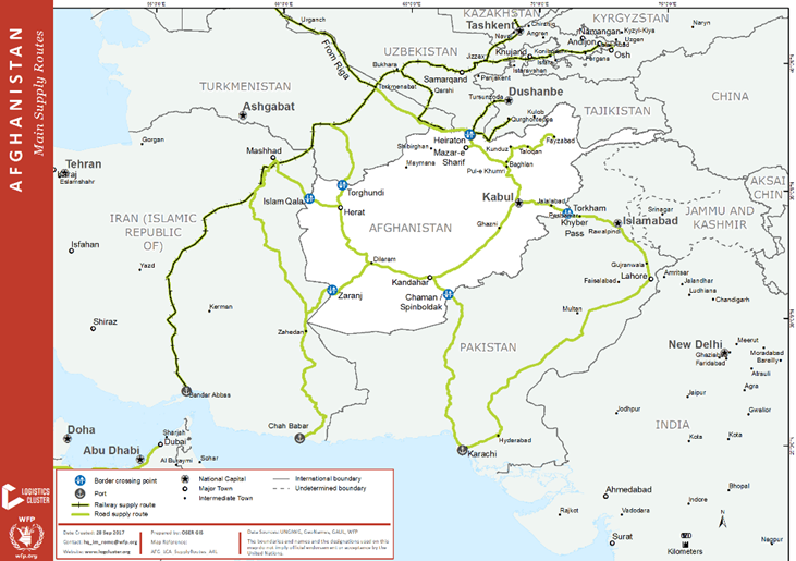
Overview
Afghanistan is a landlocked mountainous country. It is bounded by Iran (921 km 572 mi), Turkmenistan (804 km – 500 mi), Uzbekistan (144 km – 89 mi), Tajikistan (1357 km – 843 mi), China (91 km – 57 mi) and Pakistan (2670 km – 1660 mi).
Main regional freight routes and entry points through the national land border crossings are particularly significant to the humanitarian context. The geopolitical complexity of the region, the internal volatile security and the seasonal constraints on road accessibility have oriented the main humanitarian agencies operating in Afghanistan to investigate mitigation options against supply disruptions. Planning and developing potential alternative freight routes is considered a necessary precaution measure.
Most of humanitarian incoming sea-bound freight have traditionally used Pakistan Karachi and Port Qasim harbours as the main route, being the most cost effective and shortest route to the ocean.
Challenges represented by unpredictable accessibility of the traditional border points through Pakistan, and the complexity of the humanitarian logistics milieu have oriented some of the main humanitarian agencies operating in the Country (HCR, UNICEF and WFP), to assess alternative supply routes, as a contingency planning option for non-disrupted humanitarian goods streaming.
In consideration of the fact that transnational supply route necessarily entails developing consolidated information on custom procedures, and contracting with transporters and customs clearing agents, it is essential to have information on a perspective that exceed the country boundaries.
Main regional trade routes and existing and planned Infrastructure
Land
The main northern corridor links with cargo flow on the principal horizontal freight axis Kyrgyzstan/Kazakhstan/Uzbekistan/Turkmenistan, that reach Russia and China network eastbound, and reach European countries and Baltic sea ports, westbound. The network consists of road and railway infrastructures. The main entry points for this option are Torghundi and Hairaton.
The Trans-Asian Railway Network, flanked by the Trans Asian Road network, is partially planned or under construction. The below links are indicative of the Trans Asian existing and planned networks.
Maps: https://sites.google.com/site/indianoceancommunity1/trans-asian-highway
Info: https://en.wikipedia.org/wiki/Trans-Asian_Railway
Sea
Main sea-bound freight, alternative to Pakistan routes, is Iran Bandar Abbas port.
Bandar Abbas is connected through road and railway with Mashhad, Iran. Mashhad is road connected to Afghanistan through entry point Islam Qala to nearest city Herat. Mashhad it is connected via railway to Afghanistan Hairaton border crossing.
Cargo reaching Mazar-i-Sharif, through the Heiraton border preferably use the railway infrastructure from Bandar Abbas to train terminal in Heiraton.
Cargo with destination Herat use the faster road option through Zaranj/Islam Qala border.
2.3.3 Afghanistan Land Border Crossing of Torkham (Pakistan)
Overview
Torkham is one of the major international border crossings between Pakistan and Afghanistan. It connects Afghanistan's Nangarhar province with Pakistan's Federally Administered Tribal Areas (FATA) and Khyber Pakhtunkhwa. It is the busiest port of entry between the two countries, serving as a major transporting, shipping, and receiving site. Torkham is the entry point for most goods entering to the Central and Eastern Regions through the port of Karachi in Pakistan. Pakistan has completed the construction of a border gate, crossing terminal, and other associated infrastructure on its side of Torkham border in July 2016. The border gate is called Bab-i-Pakistan and the crossing terminal is called the Shaheed Major Ali Jawad Changezi Terminal.
|
Border Crossing Location and Contact |
|
|---|---|
|
Name of Border Crossing |
Torkham Border |
|
Province or District |
Mohmandra District of Nangarhar |
|
Nearest Town or City with Distance from Border Crossing |
Jalalabad City (72.8 km) |
|
Latitude |
34.122267 |
|
Longitude |
71.093725 |
|
Managing Authority / Agency |
Afghanistan Custom Department |
|
Contact Person |
Torkham Border Manager |
|
Travel Times |
|
|---|---|
|
Nearest International Airport |
Jalalabad International Airport (75.1 km) Truck Travel Time: 2 hr 30 minutes Car Travel time: 1 hr 30 minutes |
|
Nearest Port |
Karachi Port. Pakistan (1425 km) |
|
Other Information |
En route to the Torkham border to Jalalabad there are many fueling stations, hotels, and only one weighing bridge. |
|
Hours of Operation |
|
|---|---|
|
Mondays |
24 hrs |
|
Tuesdays |
24 hrs |
|
Wednesdays |
24 hrs |
|
Thursdays |
24 hrs |
|
Fridays |
24 hrs |
|
Saturdays |
24 hrs |
|
Sundays |
24 hrs |
|
National Holidays
|
21 March (Nawroz) 6 – 8 July (Eid-ul-Fitr) 18 August (Independence Day) 10 – 12 September (Eid-ul-Adha) 11 October (10th of Muharam) 12 December (Prophet’s Birthday) |
|
Seasonal Constraints |
Climate is hot desert. It receives six to eight inches (152 to 203 mm) of rainfall per annum, which are limited to winter and the months of spring. Frosts are not common, and during the summer, the mercury can reach a maximum of 120°F (49°C). The roads are fully accessible during the all season of year. Climate/seasonal constrains are not affecting the road accessibility. |
Daily Capacity
The Jalalabad-Torkham road is very important trade and transport links with Pakistan. A significant share of Afghanistan's export and import trade is carried over this road. According to the traffic count survey, the average daily traffic volume on Torkham border link road is 1390 passages, out of which 79% are trucks. Buses and private vehicles represent the remaining. After years of conflict, Afghanistan’s customs and border management infrastructure and capacity have suffered severe setbacks. Today, a large group of bilateral and multilateral donors are involved in strengthening the capacity of the Government to effectively manage its borders. This joint effort has resulted in:
- reducing customs clearance time for trucks from 428 minutes to around 90 minutes
- increasing trade volumes by 300% from USD 2 billion to USD 8 billion, according to World Bank estimates
- enhancing customs revenue collection almost 700% from USD 50 million to nearly USD 400 million
Customs Clearance
Due to lack of space the customs clearance formalities are currently executed in Jalalabad.
Incoming trucks must present a stamped document (T1 form, formerly known as Ilmo Khabar) to the Border Police before going through customs clearance. The T1 form is a cargo declaration required when importing goods into Afghanistan. It is issued by the Ministry of Finance and distributed by the Department of Customs in Afghanistan and/or Trade Commission Secretariat in Peshawar. It contains the importer's name, place of arrival and destination, desired location of customs clearance and cargo type and weight.
The Transit Permit is a mandatory document. Afghan trucks entering Pakistan must obtain the transit permit from Pakistan embassy in Kabul and Pakistani trucks entering Afghanistan must obtain a road pass at the Afghan Trade Representative in Peshawar.
Challenges and waiting time are represented by the numerous controls at the border.
At each port, consignments are often delayed up to one week before it can be declared. Container shipments from a third country moving across the Pakistan-Afghan border is dictated by the Afghan Trade and Transport Agreement (ATTA) which has many shortcomings, including monopoly of the Pakistan railway and the inspection of goods and facilities for Afghan trucks. An Afghan Trade and Transit Invoice (ATTI) is needed in addition to the T1 form to pass through border posts and obtain clearance at ICDs. Road pass authorization is also needed from the Afghan Embassy.
The following is a step-by-step description of the Border Procedures at Torkham:
- Immigration: Passport, visa and vehicle documents check for foreign vehicles.
- Weighing: Record weight on a weight slip: Total weight, less tare weight = Cargo weight. Procedure may lead to importing extra traffic unofficially by mis-declaring the tare weight.
- Registration: T1 form and invoice. Customs check documents and record the details in two registers and writing the vehicle registration on both documents.
- Physical Examination: T1 form, Invoice, Packing list and weight slip. (Visual check of goods).
- Transit Document Verification: Documents of transit cargo stamped and signed and transit document issued clearing vehicle to proceed.
- Fees Payment: Bank invoice and the stamped Form.
- Director/Deputy stamp and signature.
- Release of Goods Transit to Jalalabad or Kabul: Customs issue a note to indicate that payment has been made to avoid requests for further payment at later checkpoints.
Currently, the daily capacity of custom clearance is from 100 – 300 trucks per day.
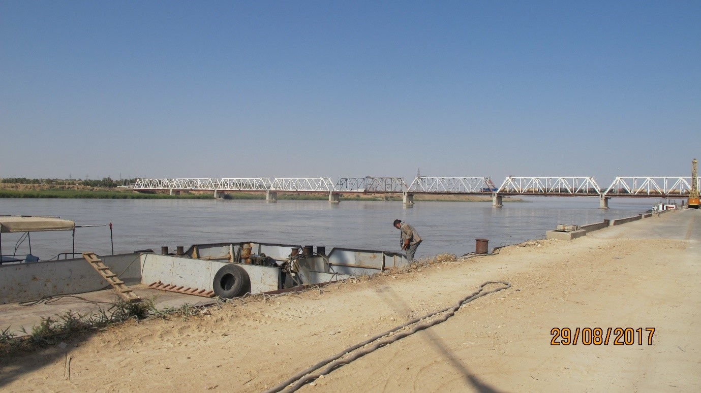
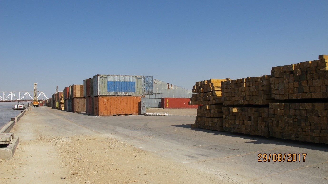
Afghanistan - 2.3.4 Afghanistan Land Border Crossing of Hairaton(Uzbekistan)
Overview
Hairaton is the main entry border point with Uzbekistan. It is an important modular hub, reached by road and railway through the Friendship Bridge, and through river crossing barges across the river Amu Darya.
Mazar is the main city in the district. The distance between Hairaton and Mazar is 76 km on a well-paved road.
|
Border Crossing Location and Contact |
|
|---|---|
|
Name of Border Crossing |
Afghanistan: Hairaton Border Crossing Uzbekistan: |
|
Province or District |
Surxondaryo Region, Uzbekistan Balkh Province, Afghanistan |
|
Nearest Town or City with Distance from Border Crossing |
Mazar (76 km) |
|
Latitude |
37.222409 |
|
Longitude |
67.430467 |
|
Managing Authority / Agency |
ASTRAS (a semi government entity in-charge for all imports whether barges, trucks or wagons). |
|
Contact Person |
|
Daily Capacity
Railway
The railway reaches Mazar Airport. It was built to be the used for supplying the NATO-ISAF mission in Afghanistan (2001 – 2014). Currently the cargo terminal is in Hairaton.
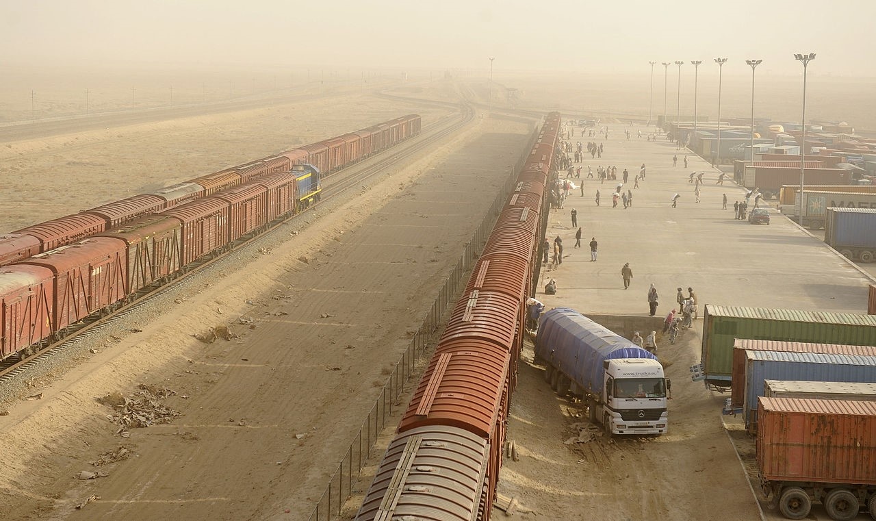
Road
The Friendship Bridge is crossed by an average of 100 trucks/day. The Customs offices are at Hairaton. Foreign trucks are requested driver’s visa.
Barges
A fleet of four barges with 200 to 400 MT capacity is available. They can carry bulk cargo. There is no Ro-Ro capacity. The barges are used mainly because cost effective in comparison to the truck fees for through the bridge.
Transshipment and Storage
Transshipment facilities are present at the barge terminal. There are 2 government owned warehouses with a total of 4000 m2 at the terminal.
Customs Clearance
All border crossing points, including Kabul Airport, Hairaton, Torkham, Islamqala, and Spinboldak follow the same customs procedures to allow cargo to enter into Afghanistan. The procedure is to provide the complete set of approved documents from the Customs and Revenue Department main office in Kabul to each entry point upon which access will be granted.
For more information on Customs in Afghanistan, please see the following link: 1.3 Afghanistan Customs Information.
2.3.5 Afghanistan Land Border Crossing of Islam Qala (Iran)
Overview
Islām Qala is a border town in the western Herat province of Afghanistan near the border with Iran. It is the official port of entry from neighboring Taybad, Iran. Islam Qala is part of the Kohsan District in Herat Province and is linked to the city of Herat via the Islam Qala-Herat Highway.
|
Border Crossing Location and Contact |
|
|---|---|
|
Name of Border Crossing |
Islam Qala |
|
Province or District |
Kohsan |
|
Nearest Town or City with Distance from Border Crossing |
Islam Qala Town (10 km) |
|
Managing Authority / Agency |
General Director of Islam Qala Border |
|
Contact Person |
Said Farid Hashimi +93 (0)796206060 |
|
Travel Times |
|
|
Nearest International Airport |
Herat Airport (135 km) Truck Travel Time: 7-8 hrs Car Travel time: 3-4 hrs |
|
Nearest Port |
Torghundi Border (230 km) Truck Travel Time: 14-15 hrs Car Travel time: 5-6 hrs |
|
Nearest location with functioning wholesale markets, or with significant manufacturing or production capacity |
Herat City (120 km) Truck Travel Time: 6-7 hrs Car Travel time: 2-3 hrs |
|
Other Information
|
Weighing Bridges are available in Islam Qala Road, 2 km to Customs. |
|
Hours of Operation |
|
|---|---|
|
Mondays |
8:00 AM to 4:00 PM |
|
Tuesdays |
8:00 AM to 4:00 PM |
|
Wednesdays |
8:00 AM to 4:00 PM |
|
Thursdays |
8:00 AM to 12:00 AM |
|
Fridays |
Off |
|
Saturdays |
8:00 AM to 4:00 PM |
|
Sundays |
8:00 AM to 4:00 PM |
|
National Holidays |
Off |
|
Seasonal Constraints |
Heavy flooding rarely results in road blockage in one point only. The border operation is never affected by weather conditions. |
Daily Capacity
Both trucks and small cars are crossing border to and from Afghanistan and Iran using one lane. An average of 130 trucks/day transit through this border. The average custom clearance processing timeis 3-4 days/truck.
Customs Clearance
Documents needed for the custom clearance:
- Tax Exemption Letter
- WB
- License
- T1 document will be provided by the forwarding agent.
Truck’s fee including the commission is around 85 USD.
Note:
Customs clearing has two steps. The initial step is at the border customs office introducing a consignment to Herat main Customs Department where customs clearing is processed and finalised for the imported goods.
2.3.6 Afghanistan Land Border Crossing of Torghundi
Overview
Torghundi is a border town in northern Herat province of Afghanistan. It is the first border crossing between Afghanistan and Turkmenistan while Aqina is the second one. The town of Serhetabat in Turkmenistan is located just a short drive from the border crossing. Torghundi is about 120 km from Herat City.
Torghundi is connected by a road plus a 1,520 mm gauge railroad with Serhetabat. The railroad was originally built in 1960 as a single track and was upgraded in 2017. Torghundi is the starting point of the Lapis Lazuli international transit route opened in 2018 linking Afghanistan to Turkey via Turkmenistan, Azerbaijan and Georgia.
|
Border Crossing Location and Contact |
|
|---|---|
|
Name of Border Crossing |
Afghanistan: Torghundi Turkmenistan: Serhetabat |
|
Province or District |
Herat Province |
|
Nearest Town or City with Distance from Border Crossing |
Herat (120 km) Elevation: 2,224 ft (678 m) |
|
Latitude |
35.257066 |
|
Longitude |
62.281585 |
|
Managing Authority / Agency |
Ministry of Commerce & Ministry of Finance |
|
Contact Person |
|
|
Travel Times |
|
|---|---|
|
Nearest International Airport |
Herat International Airport (130 km) Truck Travel Time: 5 hrs Car Travel time: 2 hrs |
|
Nearest Port |
|
|
Nearest location with functioning wholesale markets, or with significant manufacturing or production capacity |
Herat Industrial Parks (130 km) Truck Travel Time: 5 hrs Car Travel time: 2 hrs |
|
Other Information |
There are fuel stations and weighbridges on this route. |
|
Hours of Operation |
|
|---|---|
|
Mondays |
08:00 AM – 04:00 PM |
|
Tuesdays |
08:00 AM – 04:00 PM |
|
Wednesdays |
08:00 AM – 04:00 PM |
|
Thursdays |
08:00 AM – 04:00 PM |
|
Fridays |
Closed |
|
Saturdays |
08:00 AM – 04:00 PM |
|
Sundays |
08:00 AM – 04:00 PM |
|
National Holidays |
|
|
Seasonal Constraints |
|
Daily Capacity
The Torghundi Border Crossing is used mainly for railway and truck movements. There is no reliable information about exact capacity in a day but the estimated capacity is 5,000 MT of food in a day.
Customs Clearance
Customs clearing takes place at the border upon entry of goods but the rate is different for every consignment as per the rules and regulations.
For more information on customs in Afghanistan, please see the following link: 1.3 Customs Information.
Other Relevant Information
For more information on government contact details, please see the following link: 4.1 Government Contact List.