2 Sierra Leone Logistics Infrastructure
2.1 Sierra Leone Port of Freetown

Port Overview
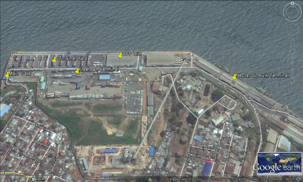
The Port of Freetown, the principal commercial port in Sierra Leone, is the most important entry gate for trade and commerce to the country. The Freetown Port (Queen Elizabeth II Quay) is located within the busy and congested eastern end of the city. It serves as the major logistics hub for Sierra Leone’s imports and exports. As an essential component of the country’s economic prosperity, this land is valuable in terms of its limited area and the need to maximize its efficiency.
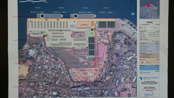
Freetown Port has one of the finest natural harbours on the West African Coast, with a well-protected anchorage, a draft at berth of 7-10 meters, a length of quay of 1,067 meters consisting of 6 berths, and sizable and fenced land area allocated for the port.
The main port for International trade is located in the city of Freetown in Sierra Leone. Freetown has many small ports for boats (Queen Elizabeth II Quay, Cline Town Government Warf, Kissy Ferry Terminal, Kissy Oil Terminal and Tagrin Ferry Terminal), Oil Tankers, Fishing Vessels and Ferries. A concession agreement was entered into on 25 November 2010 between the Sierra Leone Port Authority, the Government, and the National Commission for Privatization, Bolloré Ports, and the Freetown Terminal Limited. This agreement was in relation to the concession of the Container Terminal (berth 3-6) which came into effect as of March 2011, to use, manage, operate and maintain berths 3-6 and all surrounding areas along with the fixed assets. In September 2015 Nectar Sierra Leone Bulk Terminal concluded agreements for berths 1 & 2.
Key port information can also be found at:
|
Port Location and Contacts |
|
|---|---|
|
Country |
Sierra Leone |
|
Province or District |
Western Area |
|
Town or City (Closest location) with Distance (km) |
Name: Freetown km: 0 |
|
Port's Complete Name |
Freetown Port |
|
Latitude |
8.493228 |
|
Longitude |
-13.21312 |
|
Managing Company or Port Authority (If more than one operator, break down by area of operation) |
|
|
Management Contact Person |
|
|
Closest Airport and Frequent Airlines to / from International Destinations |
Airport Name: Lungi International Airport Airlines: Brussels Airlines, Air France, Royal Air Maroc |
Port Picture
Description and Contacts of Key Companies
The key companies and their duties within the port include Sierra Leone Port Authority, considered as the landowner of the port. Freetown Terminal Ltd manages berths 3 to 6 which include the container yard, RoRo and break bulk cargoes. Nectar Sierra Leon Bulk Terminal manages berths 1 and 2 for bulk and break bulk cargoes. The transportation by road is provided by the Indigenous Transport Owners Association (ITOA). The security is provided by Protec for Freetown Terminal Ltd and Leone International Security for the Bulk Terminal. Holland Shipyards Sierra Leone Ltd. undertakes new building, repair and conversion of small and medium-sized vessels. Cargo tracking is done by TPMS (Transport and Port Management System), also in charge of tracking and the security of cargo and containers at the Port. Port Stevedore Labour Company and Leon Duck Labour company are also operating at the port.
To access the key port companies contact list, please click on the following link: 4.4 Sierra Leone Port and Waterways Company Contact List
Port Performance
Six vessels can be berthed and operated at the same time. The cargo Handling MTs includes container volume. The channel draft is 11 meters; the longest vessel size should not be more than 236 meters. The port is not congested. There is no established priority for humanitarian cargo. The average waiting time between arrival and berthing is 0.6 day per Freetown Terminal Ltd.
|
Seasonal Constraints |
Yes / No |
From <month> to <month> |
|---|---|---|
|
Rainy Season |
Yes |
June to October |
|
Major Import Campaigns |
Yes |
November to December |
|
Other; Ramadan |
Yes |
During the month of Ramadan |
|
Handling Figures: Freetown Terminal Ltd |
Year: 2014 |
|---|---|
|
Vessel Calls |
192 |
|
Container Traffic (TEUs) |
84,665 |
|
Handling Figures: Sierra Leone Port Authority |
Year: 2014 |
| Vessel Calls | 559 |
| Container Traffic (TEUs) | 83,419 |
|
Handling Figures Bulk and Break Bulk |
Year: 2014 |
|---|---|
|
Bulk (MT) |
214,298 |
| Break Bulk (MT) | 579,730 |
Discharge Rates and Terminal Handling Charges
There is no website containing the rates and tariffs. However, it is possible to find all the discharge rates and terminal handling charges in the following annexes:
Annex I: Sierra Leone Freetown Port Clearing Tariffs for Containers
Annex II: Sierra Leone Freetown Port Port Authority Tariffs
Annex III: Sierra Leone Freetown Port Transportation Tariffs for Containers
Annex IV: Sierra Leone Freetown Terminal Port Operation Charges
Berthing Specifications
|
Type of Berth |
Quantity |
Length (m) |
Maximum Draft (m) |
|---|---|---|---|
|
Conventional Berth |
3 |
320 |
9.5 |
|
Container Berth |
2 |
380 |
10.0 |
|
Silo Berth |
No |
||
|
Berthing Tugs |
1 not functioning |
||
|
Water Barges |
No |
For more information on the berths available at the Port of Freetown please check the following websites:
www.bollore-africa-logistics.com
General Cargo Handling Berths
From berths 1-2 is 400 meters length and berths 3 – 6 is 713 meters in length. The total length overall is 1,113 meters. Berths 1 – 3 is usually reserved for break bulk vessels and general cargoes, whiles berths 4 – 6 is considered for container vessels as that is the area where you will find the container stacking yards.
|
Cargo Type |
Berth Identification |
|---|---|
|
Imports - Bagged Cargo |
All |
|
Exports - Bagged Cargo |
All |
|
Imports and Exports - RoRo |
3 - 6 |
|
Other Imports |
All |
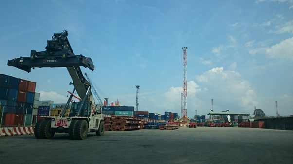
Port Handling Equipment
The Port handling equipment is managed privately by the two companies Freetown Terminal and Nectar.
The equipment here below represents the equipment of Freetown Terminal only.
|
Equipment |
Available |
Total Quantity & |
Comments on Current
Condition |
|---|---|---|---|
|
Dockside Crane |
No |
N/A | N/A |
|
Container Gantries |
No |
N/A | N/A |
|
Mobile Cranes |
Yes |
2 (3 by end of 2015) 100 mt & 125 mt |
Built in 2012 and 2015 |
|
Reachstacker |
Yes |
9 of 45 mt |
Built from 2011 to 2014 |
|
RoRo Tugmaster (w/ Trailer) |
Yes |
13 of 60 mt |
Built from 2011 to 2014 |
|
Grain Elevator w/ Bagging Machines |
No |
N/A | N/A |
|
Transtrainer |
No |
N/A | N/A |
|
Forklifts |
Yes |
6 (1x32 mt, 4x16 mt, 1x12mt, 2x4mt) |
Less than 4 years old. |
Container Facilities
The 20-year concession includes plans to renovate and modernize the container terminal. Bolloré Africa Logistics, which now employs hundreds of people at the terminal, has started a wide range of developments, including refurbishment of the container wharf, introduction of secured, computerized management, delivery of appropriate modern handling equipment. Bolloré Africa Logistics plans to pursue its investment to ensure that its customers enjoy optimal service, while doubling the volumes handled within the next five years.
|
Facilities |
20 ft |
40 ft |
|---|---|---|
|
Container Facilities Available |
Yes |
Yes |
|
Container Freight Station (CFS) |
No |
No |
|
Refrigerated Container Stations |
Yes |
Yes |
|
Other Capacity Details |
||
|
Daily Take Off Capacity (Containers per day) |
~250 TEU |
|
|
Number of Reefer Stations (connection points) |
72 |
|
|
Emergency Take-off Capacity (Give an indication) |
Normal capacity 2768 TEU + 25% |
|
|
Off take capacity of gang shift (in Containers per shift) |
380 moves |
N/A |
Customs Guidance
All containers should be scanned through the scanning machine available at the Customs in the port. The capacity of scanning is between 100 – 120 containers per day. This limits the number of containers that can be delivered from the Port.
For more information on customs at the Port of Freetown, please see the following links:
1.3 Sierra Leone Customs Information
Terminal Information
Multipurpose Terminal
Freetown Terminal is considered as multipurpose terminal.
Grain and Bulk Handling
Construction of the quay began in 1953 on what was once called Fourah Bay and was finally completed 7 years later in 1960 when it was opened by Her Majesty Queen Elizabeth II. Berths 1, 1A and 2 are designated as bulk and breakbulk specific berths and in September 2015 Nectar Sierra Leone Bulk Terminal took over control of the terminal from the Sierra Leone Port Authority (the Port Landlord). The terminal has an assortment of storage sheds for through cargo enabling safe discharge of product 24 hours per day. Direct bagging from ship discharge is possible. Nectar Group Ltd has signed a 10-year license agreement with the Government of Sierra Leone to operate the Freetown Bulk terminal located at QEII Terminal, Freetown. The new venture is named 'Nectar Sierra Leone Bulk Terminal' or NSBT. Operations started at the beginning of October 2015.
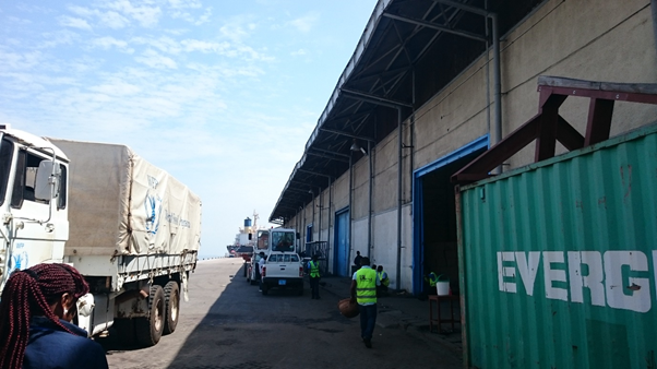
Main Storage Terminal
Limited warehousing capacity in the Port which obliges the direct delivery for bulk cargoes.
|
Storage Type |
Number of Storage Facilities |
Area (square meters) |
|---|---|---|
|
Bagged Cargo |
Yes for WFP |
5,000 |
|
Refrigerated Cargo |
No |
No |
|
General Cargo |
Yes |
5,000 |
Stevedoring
Freetown Terminal Ltd provides the stevedoring for berths 3 to 6 while Nectar Bulk Terminal provides the services to the berths 1 and 2.
Hinterland Information
The Indigenous Transport Owners Association provide the trucks to transport materials at the Port. For deliveries inside the city of Freetown, the trucks can only leave the port after 8 PM. The cost of transportation can be found in the following annex:
Annex III: Sierra Leone Freetown Port Transportation Tariffs for Containers
Port Security
Each concessionaire is responsible of the security of its concession. Freetown Terminal has subcontracted Protec Security to ensure security in its terminal while Nectar has subcontracted Leon International Security Company. CCTV have been installed in the Freeport.
|
Security |
||
|---|---|---|
|
ISPS Compliant (Yes / No) |
Yes |
|
|
Current ISPS Level |
1 |
Level 1 = Normal, Level 2 = Heightened, Level 3 = Exceptional |
|
Police Boats |
1 |
|
|
Fire Engines |
2 |
2.2 Sierra Leone Aviation

The Sierra Civil Leone Civil Aviation Authority (SLCAA), established in 2008, is charged with the following functions among others:
- To licence and regulate Civil Aviation in accordance with the obligations of Sierra Leone under the applicable International agreements so as to meet the international and domestic demands for air transportation and air cargo services including oversight in the provision, operation and maintenance of aerodromes and related facilities for aviation and to advise government on the efficient development of the aviation industry;
- To promote and develop safety in aviation, including oversight in aircraft operation, air navigation facilities and services, air traffic control, meteorological services and facilities to combat hazards to air navigation;
- To licence and register aircraft and ensure safety of air navigation.
- To licence and regulate air transport;
- To coordinate search and rescue operations;
- To certify and regulate the operations of air travel agents, etc.
The Sierra Leone Airport Authority manages Lungi International airport and all the other national airfields. Currently there is no national carrier and only UNHAS flies domestically in Sierra Leone. A private chartered company called Versatile Air Services offers domestic flights for passengers and cargo.
Sierra Leone appears on the EU list of prohibited countries with regard to the certification of airlines, which means that no airline that is Sierra Leone registered can fly into the European Union.
For more information, please see the following links:
4.1 Sierra Leone Government Contact List
4.5 Sierra Leone Airport Company Contact List
Procedures for Foreign Registered Aircraft
The following requirements need to be applied, presented and approved before preposition of foreign registered aircraft:
- Applications for permit/clearance for regular international scheduled flights and non-scheduled flights operated by foreign airlines into or in transit must be made to the Director of Civil Aviation and must be submitted at least 120 hours in advance of the intended landing.
- For private flights, a flight plan is acceptable once transmitted two hours in advance of arrival.
The application to the DCA must include:
- the name of operator
- type of aircraft
- registration marks
- certificate of airworthiness
- insurance
- information of passengers
- freight requirements
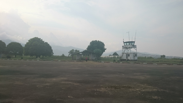
2.2.1 Sierra Leone Freetown - Lungi International Airport
Freetown Lungi International Airport is an international airport located in the coastal town of Lungi, Sierra Leone. It serves as the primary airport for domestic and international travel to and from Sierra Leone. The Sierra Leone River Separates Lungi International Airport from Freetown, the capital city of Sierra Leone. The Airport is connected to the main city through ferry and water taxi services. The road way to the city is paved and takes about 3 hours.
Sierra Leone Airports Authority is the statutory body that manages the efficient operations of the country’s Freetown International Airport, Hastings Airstrip and all Airfields and Helipads in Sierra Leone.
| Location Details | |||
|---|---|---|---|
| Country | Sierra Leone | Latitude | 8.616444 |
| Province / District | Port Loko District | Longitude | -13.19549 |
| Town or City (Closest) | Lungi | Elevation (ft and m) | 84 ft / 24 m |
| Airfield Name | Freetown Lungi International Airport | IATA and ICAO Codes | FNA/GFLL |
| Open From (hours) | 00:00 | Open To (hours) | 24:00 |
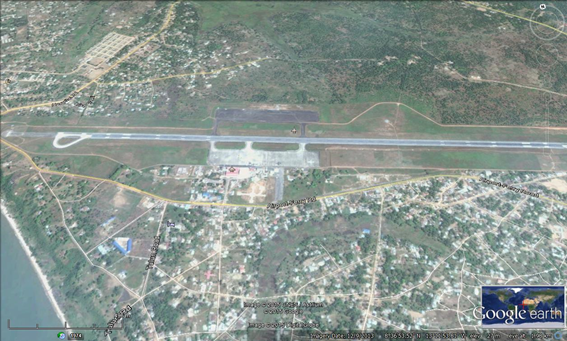
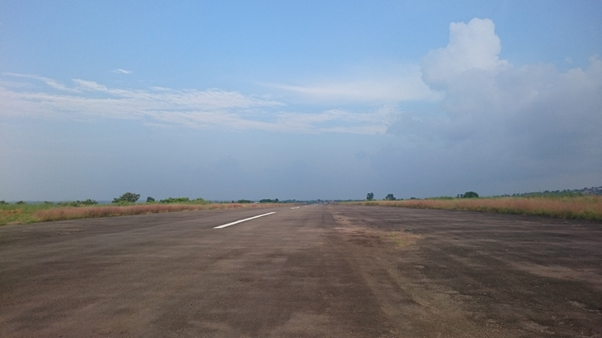
Runways
There is only one runway available at the airport.
|
Runway #1 |
|
|---|---|
|
Runway Dimensions |
3,200 m x 45.72 m (10,500 ft x 150 ft) |
|
Orientation |
12 / 30 |
|
Surface |
Asphalt |
Helicopter Pad(s)
There aren’t official helicopter pads in the international airport. Nevertheless, helicopters can land in the airport on the parking area.
Airport Infrastructure Details
The National Airport Authority has launched a project to rehabilitate the runway and to construct a taxi way to improve the airport performances.
|
Customs |
Yes |
JET A-1 fuel |
Yes |
|---|---|---|---|
|
Immigration |
Yes |
AVGAS 100 |
No |
|
Terminal Building |
Yes |
Single Point Refueling |
Yes |
|
Passenger Terminal |
Yes |
Air Starter Units |
Yes |
|
Cargo terminal |
Yes |
Ground Power (mobile) |
Yes |
|
Pax transport to airfield |
Yes |
Ground Handling Services |
Yes |
|
Control Tower |
Yes |
Latrine Servicing |
Yes |
|
Weather Facilities |
Yes |
Fire Fighting Category (ICAO) |
8 |
|
Catering Services |
Yes |
De-icing Equipment |
No |
|
Base Operating Room |
Yes |
Parking Ramp Lighting |
Yes |
|
Airport Radar |
No |
Approach & Runway Lights |
Yes |
|
NDB |
Yes |
VOR |
Yes |
|
ILS |
Yes |
Passenger and Cargo Performance Indicator
There is one terminal at the airport and 2 cargo buildings including a new one which was constructed this year and still not operational. At the departure terminal, there are 11 check-in counters, 4 customs boxes and 2 scanning machines. Additional services available include banks, exchange offices, restaurants and duty free shops.
|
Performance for 2013 |
Annual Figures |
Monthly |
Daily |
|---|---|---|---|
|
Total aircraft movements |
3,003 |
250 |
8 |
|
Total passengers |
227,649 |
18,970 |
623 |
|
Total capacity of the airport (metric tonnes) |
3,000 |
250 |
8 |
|
Current activity of the airport (metric tonnes) |
n/a |
n/a |
n/a |
|
Current use by Humanitarian flights (UNHAS) |
n/a |
n/a |
n/a |
The privatization of the handling services at the airport was a boost to improve the quality of services and to renew the handling equipment at the airport.
Airport Operating Details
| Operating Details | |||
|---|---|---|---|
| Maximum sized aircraft which can be offloaded on bulk cargo: | AN 124, Dreamliner | ||
| Maximum sized aircraft that can be offloaded on pallet | AN 72; DHL cargo of 23 mt | ||
| Total aircraft parking area (m²) | n/a | ||
| Storage Area (mt) | n/a | Cubic Meters (m³) | n/a |
| Cargo Handling Equipment Available | Yes | If "Yes" specify below | |
| Elevators / Hi Loaders | Yes | Max Capacity (mt) | n/a |
| Can elevators / hi loaders reach the upper level of a B747 | Yes | ||
| Loading Ramps | Yes | ||
Storage Facilities
There is only one hangar being used at the time being as storage facilities by SHP. The Sky Handling Partner has constructed an additional hangar to be used as a new cargo warehouse with cold chain facilities and the provision of vehicles parking facilities, but this is still not operational.
Airfield Cost
Navigation Charges
In addition to below; there are approach control charges of USD $2.50 per mt /operation and a security charge of USD $39 per departing passenger and infrastructural development charges of USD $20 per departing passenger. Lists of navigation charges and other charges can be found in the following annexes:
Annex V: Sierra Leone Freetown Airport Charges
Annex VI: Liberia Roberts Airport Charges
|
Aircraft Weight - MTOW (kg) |
Landing USD - $ |
Night Landing USD - $ |
Parking |
|
|---|---|---|---|---|
|
0 |
8,000 |
$35 flat rate |
25% surcharge between 18:01 and 19:30 50% surcharge between 19:31 and 23:30 75% surcharge between 23:31 and 07:59 |
$0.50 per hour per mt |
|
8,001 |
25,000 |
$4.625 per mt |
25% surcharge between 18:01 and 19:30 50% surcharge between 19:31 and 23:30 75% surcharge between 23:31 and 07:59 |
$0.50 per hour per mt |
|
25,001 |
50,000 |
$6.605 per mt |
25% surcharge between 18:01 and 19:30 50% surcharge between 19:31 and 23:30 75% surcharge between 23:31 and 07:59 |
$0.50 per hour per mt |
|
50,001 |
150,000 |
$8.273 per mt |
25% surcharge between 18:01 and 19:30 50% surcharge between 19:31 and 23:30 75% surcharge between 23:31 and 07:59 |
$0.50 per hour per mt |
|
150,001 |
200,000 |
$9.622 per mt |
25% surcharge between 18:01 and 19:30 50% surcharge between 19:31 and 23:30 75% surcharge between 23:31 and 07:59 |
$0.50 per hour per mt |
|
200,001 |
And over |
$9.385 per mt |
25% surcharge between 18:01 and 19:30 50% surcharge between 19:31 and 23:30 75% surcharge between 23:31 and 07:59 |
$0.50 per hour per mt |
|
Note 1: Night landing hours are between 1831 - 0759 hours Note 2: Parking charges are for each 2 hours or part thereof Note 3: All of these charges are administered by the SL Airports Authority. |
||||
Fuel Services Charges
The fuel services are provided by Total SL Ltd. There are four fixed points for refueling.
|
Price per Unit USD - $ |
|
|---|---|
|
Jet A-1 |
$1.2 per litre |
|
Avgas |
n/a |
Cargo Terminal Charges
The cargo terminal is managed by a private company called Sky Handling Partner (SHP). It carries out freight transport, operations, ramp services and passenger services for all its airline customers in Freetown. The cargo rates here below include a 15% concession fee paid to SLAA and GST at current rates of 15% will be added to these rates. For transactions outside normal working hours as well as Sunday/bank holidays, a 50% surcharge will be applicable (18:00 – 08:00). All rates published in USD and may be paid in USD or LE equivalent.
|
Import |
Rate USD - $ / kg |
|---|---|
|
Handling Charge per kg |
1 kg to 50 kg: $8 51 kg to 100 kg: $15 101 kg and above: $0.15 per kg + $8 processing fees |
|
Break Bulk Fee |
1 kg to 50 kg: $8 51 kg to 100 kg: $15 101 kg and above: $0.15 per kg + $8 processing fees |
|
Diplomatic Mail |
n/a |
|
Strong Room – per consignment |
n/a |
|
Cold Storage Fee |
Not operational |
|
Delivery outside normal working hours |
50% surcharge will be applicable (18:00 Hrs – 08:00Hrs) |
|
Preparation of substitute AOA – Invoice – Receipt |
$10 |
|
Storage per kg per day – Grace period? hours |
5 days grace period. Excluding Sundays and Public Holidays from 6th day it is $2 / kg X number of days |
|
Export |
Rate USD - $ / kg |
|
Handling charges – Unpalletized cargo |
1 kg to 50 kg: $8 51 kg to 100 kg: 5% of freight charges |
|
International Air WayBill |
$15 |
|
Local Air WayBill |
$15 |
|
Air Way Bill Amendment - Cancellation |
n/a |
|
Air Way Bill Documentation |
$10 Customs documentation; preparation of Export Proforma Entry C31 and C32 |
|
Diplomatic Mail |
n/a |
|
Storage charges per kg per day |
$2 kg X number of days |
Air-bridge Charges
There isn’t any air-bridge available at the Lungi International Airport.
Security
The security in the airport is ensured by Westminster Aviation Security Services Ltd., an internationally focused security organisation, providing fire, safety, security and defense solutions. There are two scanning machines, a walk-through metal detector at the departure terminal. Due to the Ebola outbreak, a temperature screening has been put on place. The installation of CCTV has helped in improving the security at the airport.
Companies Available
4.5 Sierra Leone Airport Company Contact List
Information on some aviation service providers can be found at: http://www.azfreight.com/
2.2.2 Sierra Leone Kenema National Airfield
Kenema is the third largest city in Sierra Leone and the largest city in the Eastern Province. The city is a major trade centre and is the capital and largest city of Kenema District. This airfield is being used only by UNHAS during the Ebola Response as a Helipad. The airfield is situated next to main paved national road leading to Mano Junction. There is a small taxi way and there are no trees obstructing.
|
Airfield Details |
|||
|---|---|---|---|
|
Country |
Sierra Leone |
Latitude |
7.897222 |
|
Province / District |
Eastern Province |
Longitude |
-11.17361 |
|
Airfield Name |
Kenema |
Elevation (ft) |
110 ft |
|
IATA & ICAO codes |
KEN & GFKE |
Surface |
Gravel |
|
Town or City (closest) |
Kenema |
Runway Condition |
Bad, holes present |
|
NGO / UN (on ground) |
WFP |
Passenger / Cargo Security Screening (Yes / No) |
No |
|
Runway Dimension |
1,100 m X 20 m |
Ground Handling (Yes / No) |
No |
|
Refueling Capacity |
No |
Runway Lighting (Yes / No) |
No |
|
Runway Heading |
No |
Fire Fighting Equipment (Yes / No) |
No |
|
Air Traffic Control (Yes / No) |
No |
Windsock (Yes / No) |
No |
|
Weather Information (Yes / No) |
No |
Aircraft Parking space (Yes / No) |
No |
|
Navigation Aids (Yes / No) |
No |
Perimeter fencing (Yes / No) |
No |
Fuel Services Charges
There is no commercial fuel available at the airfield.
Royalties / Non Objection Fees (NOFs)
No royalties charges are applicable at the airfield.
2.2.3 Sierra Leone Bo National Airfield
Bo, also commonly referred to as Bo Town, is the second largest city in Sierra Leone and the largest city in the Southern Province. The city serves as the capital and administrative center of Bo District in the Southern Province. The airfield was used only by UNHAS as a helipad during the Ebola Response. There is a tower at one of the extremities. There are no trees obstructing. A small taxi way is available.
|
Airfield Details |
|||
|---|---|---|---|
|
Country |
Sierra Leone |
Latitude |
7.943889 |
|
Province / District |
Southern Province / Bo District |
Longitude |
-11.76167 |
|
Airfield Name |
Bo |
Elevation (ft) |
328 ft |
|
IATA & ICAO codes |
KBS / GFBO |
Surface |
Gravel |
|
Town or City (closest) |
Bo |
Runway Condition |
Potholes |
|
NGO / UN (on ground) |
n/a |
Passenger / Cargo Security Screening (Yes / No) |
No |
|
Runway Dimension |
1,300 m X 20 m |
Ground Handling (Yes / No) |
No |
|
Refueling Capacity |
No |
Runway Lighting (Yes / No) |
No |
|
Runway Heading |
No |
Fire Fighting Equipment (Yes / No) |
No |
|
Air Traffic Control (Yes / No) |
No |
Windsock (Yes / No) |
No |
|
Weather Information (Yes / No) |
No |
Aircraft Parking space (Yes / No) |
No |
|
Navigation Aids (Yes / No) |
No |
Perimeter fencing (Yes / No) |
No |
Fuel Services Charges
No fuel services available at the airfield.
Royalties / Non Objection Fees (NOFs)
No royalties applicable at the airfield.
2.2.4 Sierra Leone Kumala National Airfield
The Kumala Airfield was used as helipad by UNHAS during the Ebola Response.
|
Airfield Details |
|||
|---|---|---|---|
|
Country |
Sierra Leone |
Latitude |
9.066667 |
|
Province / District |
Northern Province / Koinadugu District |
Longitude |
-11.4 |
|
Airfield Name |
Kumala |
Elevation (m) |
355 m |
|
IATA & ICAO codes |
n/a |
Surface |
Gravel and grass |
|
Town or City (closest) |
Kumala |
Runway Condition |
Fair |
|
NGO / UN (on ground) |
n/a |
Passenger / Cargo Security Screening (Yes / No) |
No |
|
Runway Dimension |
70 m X 70 m |
Ground Handling (Yes / No) |
No |
|
Refueling Capacity |
No |
Runway Lighting (Yes / No) |
No |
|
Runway Heading |
No |
Fire Fighting Equipment (Yes / No) |
No |
|
Air Traffic Control (Yes / No) |
No |
Windsock (Yes / No) |
No |
|
Weather Information (Yes / No) |
No |
Aircraft Parking space (Yes / No) |
No |
|
Navigation Aids (Yes / No) |
No |
Perimeter fencing (Yes / No) |
No |
Fuel Services Charges
No fuel services available at site.
Royalties / Non Objection Fees (NOFs)
No royalties nor landing fees applicable at the site.
2.2.5 Sierra Leone Kabala National Airfield
Kabala is the capital and largest town of Koinadugu District in the Northern Province of Sierra Leone. Kabala airfield was used as helipad by UNHAS during the Ebola Response. House and trees are within a radius of 200 m.
|
Airfield Details |
|||
|---|---|---|---|
|
Country |
Sierra Leone |
Latitude |
9.583333 |
|
Province / District |
Northern Province / Koinadugu District |
Longitude |
-11.55 |
|
Airfield Name |
Kabala |
Elevation (ft) |
1,450 ft |
|
IATA & ICAO codes |
KBA / GFKB |
Surface |
Gravel and grass |
|
Town or City (closest) |
Kabala |
Runway Condition |
n/a |
|
NGO / UN (on ground) |
n/a |
Passenger / Cargo Security Screening (Yes / No) |
No |
|
Runway Dimension |
100 m X 60 m |
Runway Lighting (Yes / No) |
No |
|
Refueling Capacity |
No |
Fire Fighting Equipment (Yes / No) |
No |
|
Runway Heading |
No |
Windsock (Yes / No) |
No |
|
Air Traffic Control (Yes / No) |
No |
Aircraft Parking space (Yes / No) |
No |
|
Weather Information (Yes / No) |
No |
Perimeter fencing (Yes / No) |
No |
|
Navigation Aids (Yes / No) |
No |
|
|
Fuel Services Charges
No fuel services at the site.
Royalties / Non Objection Fees (NOFs)
No royalties nor landing fees applicable.
2.2.6 Sierra Leone Kailahun National Airfield
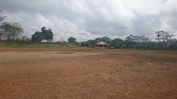
This is a temporary helipad used by UNHAS during the Ebola Response. The location is situated in Kailahun mini stadium.
|
Airfield Details |
|||
|---|---|---|---|
|
Country |
Sierra Leone |
Latitude |
8.266667 |
|
Province / District |
Eastern Province / Kailahun district |
Longitude |
-10.55 |
|
Airfield Name |
Kailahun |
Elevation (m) |
300 m |
|
IATA & ICAO codes |
n/a |
Surface |
Grass |
|
Town or City (closest) |
Kailahun |
Runway Condition |
Fair |
|
NGO / UN (on ground) |
WFP |
Passenger / Cargo Security Screening (Yes / No) |
No |
|
Runway Dimension |
100 m X 50 m |
Ground Handling (Yes / No) |
No |
|
Refueling Capacity |
No |
Runway Lighting (Yes / No) |
No |
|
Runway Heading |
No |
Fire Fighting Equipment (Yes / No) |
No |
|
Air Traffic Control (Yes / No) |
No |
Windsock (Yes / No) |
No |
|
Weather Information (Yes / No) |
No |
Aircraft Parking space (Yes / No) |
No |
|
Navigation Aids (Yes / No) |
No |
Perimeter fencing (Yes / No) |
No |
Fuel Services Charges
No fuel services available at site.
Royalties / Non Objection Fees (NOFs)
No royalties or landing fees applicable.
2.2.7 Sierra Leone Kambia National Airfield
A temporary helipad used by UNHAS during the Ebola Response. The location is situated inside the Kambia Military Base.
|
Airfield Details |
|||
|---|---|---|---|
|
Country |
Sierra Leone |
Latitude |
9.1 |
|
Province / District |
Northern Province / Kambia District |
Longitude |
-12.91667 |
|
Airfield Name |
Kambia |
Elevation (m) |
50 m |
|
IATA & ICAO codes |
n/a |
Surface |
Gravel and grass |
|
Town or City (closest) |
Kambia |
Runway Condition |
Fair |
|
NGO / UN (on ground) |
WFP |
Passenger / Cargo Security Screening (Yes / No) |
No |
|
Runway Dimension |
150 m X 150 m |
Ground Handling (Yes / No) |
No |
|
Refueling Capacity |
No |
Runway Lighting (Yes / No) |
No |
|
Runway Heading |
No |
Fire Fighting Equipment (Yes / No) |
No |
|
Air Traffic Control (Yes / No) |
No |
Windsock (Yes / No) |
No |
|
Weather Information (Yes / No) |
No |
Aircraft Parking space (Yes / No) |
No |
|
Navigation Aids (Yes / No) |
No |
Perimeter fencing (Yes / No) |
No |
Fuel Services Charges
No fuel services available at the site.
Royalties / Non Objection Fees (NOFs)
No royalties or landing fees applicable.
2.2.8 Sierra Leone Koidu National Airfield
Koidu Airfield is a temporary helipad used by UNHAS during the Ebola Response.
|
Airfield Details |
|||
|---|---|---|---|
|
Country |
Sierra Leone |
Latitude |
8.65 |
|
Province / District |
Eastern Province / Kono District |
Longitude |
-10.95 |
|
Airfield Name |
Koidu |
Elevation (ft) |
1,246 ft |
|
IATA & ICAO codes |
n/a |
Surface |
Gravel and grass |
|
Town or City (closest) |
Koidu |
Runway Condition |
Fair |
|
NGO / UN (on ground) |
n/a |
Passenger / Cargo Security Screening (Yes / No) |
No |
|
Runway Dimension |
80 m X 50 m |
Ground Handling (Yes / No) |
No |
|
Refueling Capacity |
No |
Runway Lighting (Yes / No) |
No |
|
Runway Heading |
No |
Fire Fighting Equipment (Yes / No) |
No |
|
Air Traffic Control (Yes / No) |
No |
Windsock (Yes / No) |
No |
|
Weather Information (Yes / No) |
No |
Aircraft Parking space (Yes / No) |
No |
|
Navigation Aids (Yes / No) |
No |
Perimeter fencing (Yes / No) |
No |
Fuel Services Charges
No fuel services available at site.
Royalties / Non Objection Fees (NOFs)
No royalties at site.
2.2.9 Sierra Leone Makeni National Airfield
Makeni Airfield is temporary helipad used by UNHAS during the Ebola Response. The location is a football field in the Makeni military base.
|
Airfield Details |
|||
|---|---|---|---|
|
Country |
Sierra Leone |
Latitude |
8.866667 |
|
Province / District |
Northern Province / Bombali District |
Longitude |
-12.01667 |
|
Airfield Name |
Makeni |
Elevation (ft) |
400 ft |
|
IATA & ICAO codes |
n/a |
Surface |
Gravel and grass |
|
Town or City (closest) |
Makeni |
Runway Condition |
Fair |
|
NGO / UN (on ground) |
WFP |
Ground Handling (Yes /
No)
|
No |
|
Runway Dimension |
300 ft X 150 ft |
Runway Lighting (Yes / No) |
No |
|
Refueling Capacity |
No |
Fire Fighting Equipment (Yes / No) |
No |
|
Runway Heading |
No |
Windsock (Yes / No) |
No |
|
Air Traffic Control (Yes / No) |
No |
Aircraft Parking space (Yes / No) |
No |
|
Weather Information (Yes / No) |
No |
Perimeter fencing (Yes / No) |
No |
|
Navigation Aids (Yes / No) |
No |
|
|
Fuel Services Charges
No fuel services available at site.
Royalties / Non Objection Fees (NOFs)
No royalties at site.
2.2.10 Sierra Leone Yengema National Airfield
Trees may pose obstructions in the approach and take off. The runway has potholes.
|
Airfield Details |
|||
|---|---|---|---|
|
Country |
Sierra Leone |
Latitude |
8.6 |
|
Province / District |
Eastern Province / Kono District |
Longitude |
-11.03333 |
|
Airfield Name |
Yengema |
Elevation (m) |
70 m |
|
IATA & ICAO codes |
WYE / GFYE |
Surface |
Concrete/Asphalt |
|
Town or City (closest) |
Yengema |
Runway Condition |
Potholes |
|
NGO / UN (on ground) |
n/a |
Passenger / Cargo Security Screening (Yes / No) |
No |
|
Runway Dimension |
1,300 ft x 50 ft |
Ground Handling (Yes / No) |
No |
|
Refueling Capacity |
No |
Runway Lighting (Yes / No) |
No |
|
Runway Heading |
No |
Fire Fighting Equipment (Yes / No) |
No |
|
Air Traffic Control (Yes / No) |
No |
Windsock (Yes / No) |
No |
|
Weather Information (Yes / No) |
No |
Aircraft Parking space (Yes / No) |
No |
|
Navigation Aids (Yes / No) |
No |
Perimeter fencing (Yes / No) |
No |
Fuel Services Charges
No fuel services available at site.
Royalties / Non Objection Fees (NOFs)
No royalties at site.
2.2.11 Sierra Leone Port Loko National Airfield
Port Loko Airfield is a temporary helipad used only by UNHAS during the Ebola Response. The helipad is located in the premises of the Main Logistics Base of Port Loko.
|
Airfield Details |
|||
|---|---|---|---|
|
Country |
Sierra Leone |
Latitude |
8.766667 |
|
Province / District |
Northern Province / Port Loko district |
Longitude |
-12.76667 |
|
Airfield Name |
Port Loko |
Elevation (ft) |
160 ft |
|
IATA & ICAO codes |
n/a |
Surface |
Gravel and Grass |
|
Town or City (closest) |
Port Loko |
Runway Condition |
Fair |
|
NGO / UN (on ground) |
WFP |
Passenger / Cargo Security Screening (Yes / No) |
No |
|
Runway Dimension |
100 m x 100 m |
Ground Handling (Yes / No) |
No |
|
Refueling Capacity |
No |
Runway Lighting (Yes / No) |
No |
|
Runway Heading |
n/a |
Fire Fighting Equipment (Yes / No) |
No |
|
Air Traffic Control (Yes / No) |
No |
Windsock (Yes / No) |
No |
|
Weather Information (Yes / No) |
No |
Aircraft Parking space (Yes / No) |
No |
|
Navigation Aids (Yes / No) |
No |
Perimeter fencing (Yes / No) |
Yes |
Fuel Services Charges
No commercial Fuel services available at the airfield.
Royalties / Non Objection Fees (NOFs)
No royalties at site.
2.2.12 Sierra Leone Hastings National Airfield
Hastings is a town in the Rural District in the Western Area of Sierra Leone. The town has a population of 15,054 and lies approximately 15 miles east of Freetown. The Hasting Airfield is an abandoned airfield with a paved runway and a helipad which was used by the different UN missions in Sierra Leone.
|
Airfield Details |
|||
|---|---|---|---|
|
Country |
Sierra Leone |
Latitude |
8.394444 |
|
Province / District |
Western Area / Rural District |
Longitude |
-13.12833 |
|
Airfield Name |
Hastings |
Elevation (ft) |
110 ft |
|
IATA & ICAO codes |
HGS & GFHA |
Surface |
Tarmac |
|
Town or City (closest) |
Freetown |
Runway Condition |
Fair |
|
NGO / UN (on ground) |
n/a |
Passenger / Cargo Security Screening (Yes / No) |
No |
|
Runway Dimension |
960 m x 20 m |
Ground Handling (Yes / No) |
No |
|
Refueling Capacity |
No |
Runway Lighting (Yes / No) |
No |
|
Runway Heading |
08/26 |
Fire Fighting Equipment (Yes / No) |
No |
|
Air Traffic Control (Yes / No) |
No |
Windsock (Yes / No) |
No |
|
Weather Information (Yes / No) |
No |
Aircraft Parking space (Yes / No) |
No |
|
Navigation Aids (Yes / No) |
No |
Perimeter fencing (Yes / No) |
No |
Fuel Services Charges
No fuel services at site.
Royalties / Non Objection Fees (NOFs)
No royalties nor landing fees applicable.
2.2.13 Sierra Leone Cockerill National Airfield
The Cockerill Airfield is located in a military base in Freetown. The helipad used by UNHAS during the Ebola Response.
|
Airfield Details |
|||
|---|---|---|---|
|
Country |
Sierra Leone |
Latitude |
8.4739906 |
|
Province / District |
Western Area Urban District |
Longitude |
-13.2776427 |
|
Airfield Name |
Cockerill |
Elevation (m) |
355 m |
|
IATA & ICAO codes |
n/a |
Surface |
Concrete/Asphalt |
|
Town or City (closest) |
Freetown |
Runway Condition |
Good |
|
NGO / UN (on ground) |
n/a |
Passenger / Cargo Security Screening (Yes / No) |
n/a |
|
Runway Dimension |
35 m (circular shape) |
Ground Handling (Yes / No) |
n/a |
|
Refueling Capacity |
n/a |
Runway Lighting (Yes / No) |
n/a |
|
Runway Heading |
n/a |
Fire Fighting Equipment (Yes / No) |
n/a |
|
Air Traffic Control (Yes / No) |
n/a |
Windsock (Yes / No) |
Yes |
|
Weather Information (Yes / No) |
n/a |
Aircraft Parking space (Yes / No) |
n/a |
Fuel Services Charges
No commercial fuel services at the site
Royalties / Non Objection Fees (NOFs)
No royalties nor landing fees applicable.
2.3 Sierra Leone Road Assessment

Road transport is the most dominant mode of transport and
represents about 85% of the entire transport system in Sierra
Leone. 95% of the inland transport of passengers and goods is
carried out on roads. Sierra Leone has a public road network of
about 11,700 kilometres of which 8,700 km are functionally
classified in the National Road System. The other 3,000 km consists
of local roads and unclassified roads and tracks. The Sierra Leone
Roads Authority (SLRA) manages the national roads. Ministry of
Transport and Aviation (MoTA) provides the policy and regulatory
framework for transport management in Sierra Leone. It is the
overall body responsible for policy formulation in the area of road
safety in the country. The Ministry has the mandate to draft and
table amendments of traffic regulations to Parliament. The Ministry
of Works, Housing and Infrastructure (MOWHI) oversees the policy
guidance and execution of the Road, Housing and Infrastructure
sectors in the country. It is in charge of the construction,
reconstruction, rehabilitation and overall maintenance of the road
sector infrastructure. It took on the management of the feeder
roads a few years ago.
|
Classification |
Description |
Network Length |
Paved |
Surface Condition |
|---|---|---|---|---|
|
A |
Primary roads connect the capital with the three provincial capitals, as well as with the district Centres, and also include international routes |
2,332 km |
925 km |
Good in general |
|
B |
Secondary roads connect the District Centres, serve as regional
main roads and are connectors between primary roads and other
secondary roads |
2,091 km |
46 km |
Bad during the rainy season |
|
C |
Feeder roads |
4,277 km |
0 km |
Inaccessible during the rainy season |
|
|
Urban roads |
3,000 km |
80 km |
|
Approximately 11,000 km of public
road network; Approx. 8,000 Km classified in National Road System
(NRS); Approx. 3,000 Km local network and unclassified roads and
tracks.
To access the Road Network Government Contact List, please click on the following link: 4.1 Sierra Leone Government Contact List
Distance Matrix
To access the detailed Road Distance Matrix, please see the following annex: Annex VII: Sierra Leone Road Distance Matrix
To view access constraints in Sierra Leone, please see the following annex: Annex VIII: Sierra Leone National Road Condition
Road Security
The road safety situation in Sierra Leone is serious and has deteriorated over the past years, mainly due to the growing numbers of vehicles and ineffective implementation of the road safety interventions. There are currently no routine regular road safety audits in place on the entire road network and no compliance regimes. Local drivers do not follow general road safety rules.
Weighbridges and Axle Load Limits
There aren’t any weighbridges and axle load limits in Sierra Leone even though it is requested by ECOWAS regulations. This lack of limits control affects the roads and their maintenance as most of the trucks are over loaded.
2.3.1 Sierra Leone Border Crossing of Baidu
Overview
Baidu border crossing is an international crossing between Sierra Leone and Liberia. The following services have their agents at the post:
- Health
- Customs
- Immigration
- Security
- Police
- Army
- Interpol
- Intelligence
|
BORDER CROSSING LOCATION & CONTACT |
|
|---|---|
|
Name of Border Crossing:
|
Baidu [Sierra Leone] Mendekoma [Liberia] |
|
Province or District: |
Kailahun |
|
Nearest Town or City: |
Koindu |
|
Latitude: |
8.4715 |
|
Longitude: |
-10.27694 |
|
Managing Authority/Agency: |
NRA |
|
Contact Person |
Mohammad Duckry, Collector, Tel. +23278628965 Mr Ansumana Borbor, Public Health Aide, Port Health Office Baidu tel. +2327755628 |
|
Travel Times |
|
|---|---|
|
Nearest International Airport: |
Lungi International Airport Distance: 515 km Truck: 2 days Car: 8 hours |
|
Nearest Port: |
Freetown Port Distance: 455 km Truck: 2 days Car: 8 hours |
|
Nearest Major Market: |
Kenema Distance: 165 km Truck: 6 Car: 3 |
|
Other Information: |
No fueling station available nor weighing bridges. |
|
Hours of Operation |
|
|---|---|
|
MONDAYS |
0800 - 1800 |
|
TUESDAYS |
0800 - 1800 |
|
WEDNESDAYS |
0800 - 1800 |
|
THURSDAYS |
0800 - 1800 |
|
FRIDAYS |
0800 - 1800 |
|
SATURDAYS |
0800 - 1800 |
|
SUNDAYS |
0800 - 1800 |
|
NATIONAL HOLIDAYS: |
0800 - 1800 |
|
SEASONAL CONSTRAINTS: |
The rainy season affects the accessibility to the post from the Sierra Leone side. |
Daily Capacity
In average 10 persons per day pass the border. One 8-wheeled truck loaded with fish from Freetown passes by every month (dry and rainy season) to sell the fish at Foya market. The Foya market opens on Saturdays while the Koindu market opens on Thursdays. Saturdays are the busiest day of the week as a van (with 6 wheels) does the trip between the two towns carrying passengers and goods.
Customs Clearance
There is a custom office at the border point with a computer to issue the relevant documents. Unfortunately, there is no electricity available at the post so all the documents are hand written. Inspections are carried out on the cargoes to verify their content and quantity in conformity with the manifest.
Other Relevant Information
There is no electricity at the border post and no fuel for the generator, which also needs maintenance. The water system is poor and the drinking water pump is damaged. The nearest health facility is in Koindu.
For more information, please see the following
link: 4.1 Sierra
Leone Government Contact List
2.3.2 Sierra Leone Border Crossing of Gbalamuya
Overview
This joint border post can be found in the Kambia district and in Gbalamuya Town along the Republics of Sierra Leone and Guinea. It was constructed with funds from the European Union in order to facilitate and promote trade. The road from Freetown to Gbalamuya is paved and in good condition.
|
BORDER CROSSING LOCATION & CONTACT |
|
|---|---|
|
Name of Border Crossing: |
Gbalamuya [Sierra Leone] Pamelap [Guinea] |
|
Province or District: |
Kambia |
|
Nearest Town or City: |
Kambia |
|
Latitude: |
9.175333 |
|
Longitude: |
-12.96219 |
|
Managing Authority/Agency: |
National Revenue Authority (NRA) |
|
Contact Person |
Customs: Denis Bola Godwin, Collector, tel. +23230971123 Immigration: Musa S. Kargbo, Assistant Immigration Officer, tel. +23276682582 and +23288922132 Gbalamuya Border Post Office Kambia: 23222292734, 23222290544 info@nra.gov.sl |
|
Travel Times |
|
|---|---|
|
Nearest International Airport: |
Lungi International Airport Distance: 115 km Truck: 3 hours Car: 2 hours |
|
Nearest Port: |
Freetown International Airport Distance: 185 km Truck: 5 hours Car: 3 hours |
|
Nearest Major Market: |
Port Loko Distance: 61 km Truck: 2 hours Car: 1 hours |
|
Other Information:
|
There are fueling stations along the road but there aren’t any weighing bridges. |
|
Hours of Operation |
|
|---|---|
|
MONDAYS |
0700 - 1900 |
|
TUESDAYS |
0700 - 1900 |
|
WEDNESDAYS |
0700 - 1900 |
|
THURSDAYS |
0700 - 1900 |
|
FRIDAYS |
0700 - 1900 |
|
SATURDAYS |
0700 - 1900 |
|
SUNDAYS |
0700 - 1900 |
|
NATIONAL HOLIDAYS: |
0700 - 1900 |
|
SEASONAL CONSTRAINTS: |
None |
Daily Capacity
Private cars are provided a separate lane. The level of traffic is still low due to the Ebola outbreak. Most of the traffic is composed of small cars or vans. Around 20 trucks per month pass the border post.
Customs Clearance
In order to obtain customs clearance, it is necessary to contact a clearing agent. The clearing agent will establish a manifest document detailing the goods' description, quantity and value. It is the only document needed at the border. It must be submitted first to Anti-Smuggling Unit (ASU), which will verify and inspect the goods then stamp and sign the manifest. (An Examining Officer will go out to verify the description and quantity of the items mentioned on the manifest.) The document then is submitted to the Collector for valuation purpose. After the valuation, the items are entered into Asycuda system. After inputting, the clearing agent takes the document to the bank available in the same building and makes the necessary payment. After the payment, the document goes to In-gate section which will check to ensure that the correct Harmonized System (HS) code is used. The In-gate officer triggers the activity. The system will send the document to an examining officer at the border who will examine the vehicle and the cargo to ensure it is consistent with the declaration on the manifest. If the cargo is not consistent, then payment of additional fees must occur. After the examining officer establishes the inspection act (electronic description in the system). The ASU unit validates it after assessment and checks the inspection act. If correct, they assess the document, which will be submitted to the collector who will print a release copy attached to the document for the collector’s signature and stamp. The release and the bank receipt will be given to the importer for him to go with the goods. This process takes approximately 30 minutes.
Other Relevant Information
It takes around 30 minutes to cross the border. If customs at the border does not clear an imported car, it will be escorted to the Customs yard in Freetown where it will be parked until the importer finalizes the importation documents.
For more information, please see the following link: 4.1 Sierra Leone Government Contact List
2.3.3 Sierra Leone Border Crossing of Yenga
Overview
At this crossing point, there are representatives from the Security, Customs, Phytosanitary, and Immigration. The phytosanitary agents inspect all medical goods and food. There is no bridge to cross the Moa river, therefore the use of the ferry is obligatory. The ferry is managed by the Guineans. On the Guinean side, the National Road n. 16 leads to Guékedou.
|
BORDER CROSSING LOCATION & CONTACT |
|
|---|---|
|
Name of Border Crossing: |
Yenga [Sierra Leone] Nongoa [Guinea] |
|
Province or District: |
Eastern Province / Kailahun |
|
Nearest Town or City: |
Koindu |
|
Latitude: |
8.49975 |
|
Longitude: |
-10.33156 |
|
Managing Authority/Agency: |
NRA / Joint Security Force |
|
Contact Person |
Yenga Border Post Office Mustafa M. Bockarie, Border Patrol Assistant, tel. 076173277 and 077403099 Jonathan T. Gborie, Customs Vigilantee, tel. +23288603858 and +23278693882 |
|
Travel Times |
|
|---|---|
|
Nearest International Airport: |
Lungi International Airport Distance: 507 km Truck: 2 days Car: 8 hours |
|
Nearest Port: |
Freetown Port Distance: 455 km Truck: 2 days Car: 8 hours |
|
Nearest Major Market: |
Kailahun Distance: 41 km Truck: 4 hours Car: 2 hours |
|
Other Information:
|
There are no fueling stations or weighing bridges en-route. |
|
Hours of Operation |
|
|---|---|
|
MONDAYS |
0600 - 1800 |
|
TUESDAYS |
0600 - 1800 |
|
WEDNESDAYS |
0600 - 1800 |
|
THURSDAYS |
0600 - 1800 |
|
FRIDAYS |
0600 - 1800 |
|
SATURDAYS |
0600 - 1800 |
|
SUNDAYS |
0600 - 1800 |
|
NATIONAL HOLIDAYS: |
0600 - 1800 |
|
SEASONAL CONSTRAINTS: |
During the rainy season, the access to the border becomes difficult due to the bad condition of the road but the post is always open. |
Daily Capacity
The daily traffic is usually 20 persons in majority on motorbikes. There is only 1 trailer per year but trucks of 10 mt are more frequent. In order to cross to the Guinean side, the use of the ferry is obligatory. The ferry can take up to a 20 mt truck. The vehicles should have a laisser-passer from Freetown endorsed by the immigration. In case a person arrives without a visa then he will be escorted to Kenema office where he can obtain the visa for 30 days. Only one motorbike is available. It takes 20 minutes to finish the clearing formalities.
Customs Clearance
The goods passing through this post are mostly composed of local products. A manifest is prepared by the drivers and checked by the customs. Depending on the quantity and the type of product, the custom duty is estimated and should be paid cash according to a receipt. For any transit, the documents should be prepared at Freetown and escorted by the customs officials. In case a transit truck arrives at the border, it will be escorted to the main customs office which is located in Baidu. There are 36 crossing points but only two are international borders; the Yenga and Baidu posts.
Other Relevant Information
The goods are inspected by the officials at the border point.
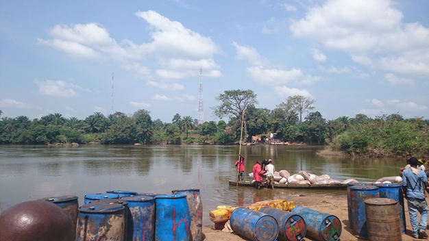
The ferry at the Guinean side and the canoes used to cross the Moa River.
For more information, please see the following link: 4.1 Sierra Leone Government Contact List
2.3.4 Sierra Leone Border Crossing of Bo-Waterside
Overview
Bo-Waterside is an international border crossing post between Sierra Leone and Liberia. The road from Kenema to the border point is very bad and during the rainy season it becomes more difficult to access and might take few days to go through due to the traffic and potholes along the road.
|
BORDER CROSSING LOCATION & CONTACT |
|
|---|---|
|
Name of Border Crossing:
|
Bo-Waterside [Sierra Leone] Gendema [Liberia] |
|
Province or District: |
Southern Province / Pujehun District |
|
Nearest Town or City: |
Zimmi |
|
Latitude: |
7.019222 |
|
Longitude: |
-11.377 |
|
Managing Authority/Agency: |
NRA |
|
Contact Person |
Tel. 23222292734 Tel. 23222290544 |
|
Travel Times |
|
|---|---|
|
Nearest International Airport: |
Lungi International Airport via Masiaka-Yonibana Highway Distance: 426 km Truck: 2 days Car: 8 hours |
|
Nearest Port: |
Freetown Port Distance: 386 km Truck: 2 days Car: 8 hours |
|
Nearest Major Market: |
Pujehun Distance: 112 km Truck: 1 day Car: 4 hours |
|
Other Information:
|
There are some fueling stations along the road. There are not weighing bridges. |
|
Hours of Operation |
|
|---|---|
|
MONDAYS |
0800 - 1700 |
|
TUESDAYS |
0800 - 1700 |
|
WEDNESDAYS |
0800 - 1700 |
|
THURSDAYS |
0800 - 1700 |
|
FRIDAYS |
0800 - 1700 |
|
SATURDAYS |
0800 - 1700 |
|
SUNDAYS |
0800 - 1700 |
|
NATIONAL HOLIDAYS: |
No National Holidays |
|
SEASONAL CONSTRAINTS: |
Rainy season due to the road condition. |
Daily Capacity
N/A
Customs Clearance
There are no fees on trucks or vehicles leaving the country. They need to have a laissez-passer obtained from Freetown Customs.
Other Relevant Information
The trucks are subject to physical inspection to ensure that the quantity and content of the cargoes correspond to what mentioned in the Manifest.
For more information, please see the following link: 4.1 Sierra Leone Government Contact List
2.4 Sierra Leone Railway Assessment

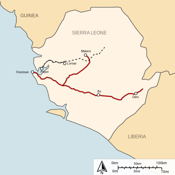
The national railway system was closed down in 1975 after a recommendation from the UN special fund. Volumes were low and maintenance costs high. At its height the narrow gauge railway lines stretched from Freetown to Pendembu in the east and from Freetown to Makeni – a total of 458 km. There was also a private mine railway (from Lunsar to Pepel) and a Mountain Railway in Freetown. There are 84 kilometres of railway in Sierra Leone, all of which is private and of a narrow gauge, 1,067 mm (3 ft 6 in). Sierra Leone no longer has any common carrier railroads, as the 762 mm (2 ft 6 in) gauge Sierra Leone Government Railway from Freetown through Bo to Kenema and Daru, with a branch to Makeni, closed in 1974. The country does not share rail links with adjacent countries, Guinea and Liberia. The existing railway between the port of Pepel and the Marampa iron ore mine is being refurbished by African Minerals PLC. This is a common carrier railway, but will be used predominantly for transporting iron ore. African Minerals is also constructing a new standard gauge railway from the Tonkolili iron ore mine to a new port at Tagrin Point.
For more information, please see the following link: 4.1 Sierra Leone Government Contact List
2.5 Sierra Leone Waterways Assessment

Maritime transport services are managed by the Sierra Leone Port Authority, Sierra Leone Maritime Authority and Sierra Leone Maritime Administration. There is only a limited river transport system (270 km) during the rainy season. Major ports of Sierra Leone include: Bonthe, Freetown and Pepel. Queen Elizabeth II Quay in Freetown represents the country's only deep water port facility capable of berthing large-hulled cargo or military vessels.
For more information, please see the following link: 4.1 Sierra Leone Government Contact List
Company Information
For more information, please see the following link: 4.4 Sierra Leone Port and Waterways Company Contact List
2.6 Sierra Leone Storage Assessment
Storage facilities are limited in Sierra Leone. It is possible to find them in Freetown but it becomes more difficult to locate inside the country. During the Ebola Response, WFP established different warehousing facilities in the country with Port Loko as the main hub. These storage facilities were to be used by all the humanitarian actors in the frame of the Ebola Response.
For more information, please see the following link: 4.6 Sierra Leone Storage and Milling Company Contact List
Commercial Storage
|
Location |
Owner |
Available for Rent |
Capacity |
Type [1] |
Access [2] |
Condition [3] |
|---|---|---|---|---|---|---|
|
Kenema |
Tropical Farms Limited |
Yes for 400 m² (1,600 m² rented to Red Cross) |
2,000 m² |
Concrete |
Flat |
Appears intact |
|
Freetown - Cline Town |
JIL |
Service only |
|
Container |
Flat |
Appears intact |
|
Freetown - Cline Town |
JIL |
Service only |
Open Storage |
Flat |
Appears intact |
|
|
Freetown - Cline Town |
JIL |
Service only |
450 m² |
Concrete |
Flat |
Appears intact |
|
Freetown - Cline Town |
JIL |
Service only |
200 m² |
Concrete |
Flat |
Appears intact |
|
Freetown - Cline Town |
JIL |
Service only |
170 m² |
Concrete |
Flat |
Appears intact |
|
Kenema |
JIL |
Service only |
750 m² |
Concrete |
Flat |
Appears intact |
|
Kenema |
JIL |
Service only |
750 m² |
Concrete |
Flat |
Under Construction/repair |
|
Freetown – Cline Town |
JIL |
n/a |
13,700 m³ |
Concrete |
Flat |
Under Construction/repair |
|
Freetown - Goderitch |
Mohamed Wurie |
Yes |
500 m² |
Concrete |
Flat |
Appears intact |
|
Freetown - Brookfields |
Mohamed Wurie |
Yes |
800 m³ |
Concrete |
Flat |
Appears intact |
|
Freetown - Kingtom |
Simon Wilson |
Yes |
1,533 m³ |
Concrete |
Flat |
Appears intact |
|
Freetown - DownTown |
Simon Wilson |
Yes |
504 m³ |
Concrete |
Flat |
Appears intact |
|
Freetown – Cline Town |
Simon Wilson |
Yes |
3,360 m³ |
Concrete |
Flat |
Under Construction/repair |
|
Freetown - Kissy |
Simon Wilson |
Yes |
6,300 m³ |
Concrete |
Flat |
Appears intact |
|
Kenema |
Fawaz Building Materials |
Yes |
2,700 m² |
Concrete |
Flat |
Appears intact |
|
Freetown - No 6 Main Motor Road Waterloo |
Gibrill Sheriff Kamara |
Yes |
125 mt / 111 m² 271 m³ |
Concrete |
Flat |
Appears intact |
|
Freetown - Palm Kernel Oil Mill, Wellington Industrial Area, opposite PMB junction |
Sierra Leone Insurance company and Sign Africa |
Yes |
1,769 m² |
Concrete |
Flat |
Appears intact |
[1] Warehouse Type: Open storage, container,
rub-hall, silo, concrete, other, unspecified
[2] Warehouse Access: Raised-siding,
flat
[3] Warehouse condition: Appears intact,
appears damaged, under construction/repair
Storage Used by Humanitarian Organizations
The major humanitarian organizations store their items in Freetown. The main preference is to run their own facilities. The largest organization storing items in the country is WFP. During the Ebola Crisis, WFP provided storage facilities to both the humanitarian organizations and the different government entities. The lack of adequate commercial and public storage facilities was surmounted by providing Mobile Storage Unit (Wiikhalls/Rub halls).
|
Location |
Organization |
Sharing
Possibility |
Capacity |
Type [1] |
Access [2] |
Condition [3] |
|---|---|---|---|---|---|---|
|
Portshed IV |
WFP |
Yes (upon available space) |
5,000 mt / 2500 m² |
concrete |
flat |
Good |
|
Portshed IVA |
WFP |
Yes (upon available space) |
5,000 mt / 2500 m² |
concrete |
flat |
Good |
|
Kissy -1 |
WFP |
Yes (upon available space) |
450 mt / 325 m² |
Concrete |
Flat |
Good |
|
Kissy -2 |
WFP |
Yes (upon available space) |
450 mt / 655 m² |
Concrete |
Raised-siding |
Good |
|
Kissy -3 |
WFP |
Yes (upon available space) |
500 mt / 787 m² |
Concrete |
Flat |
Good |
|
Kissy |
WFP |
Yes (upon available space) |
1,950 mt / 720 m² |
Rub-hall |
Raised-siding |
Appears damaged |
|
Makeni |
WFP |
Yes (upon available space) |
3,000 mt / 1700 m² |
Rub-hall |
Raised-siding |
Good |
|
Makeni |
WFP |
Yes (upon available space) |
500 mt / 320 m² |
Rub-hall |
Raised-siding |
Appears damaged |
|
Port Loko |
WFP |
Yes (upon available space) |
1,500 mt / 787 m² |
Concrete |
Flat |
Appears intact |
|
Kenema |
WFP |
Yes (upon available space) |
2,300 mt / 525 m² |
Concrete |
Raised-siding |
Appears intact |
|
Kenema |
WFP |
Yes (upon available space) |
2,600 mt / 960 m² |
Rub-hall |
Raised-siding |
Appears intact |
|
Freetown |
UNICEF |
Yes (upon available space) |
5,583 m² |
Concrete |
Flat |
Appears intact |
|
Kenema |
UNICEF |
Yes (upon available space) |
52 mt / 56 m² / 135 m³ |
Container |
Flat |
Appears intact |
|
Makeni |
UNICEF |
Yes (upon available space) |
52 mt / 56 m² / 135 m³ |
Container |
Flat |
Appears intact |
|
Freetown |
Handicap |
n/a |
26 mt / 23 m² / 67 m³ |
Container |
Flat |
Appears intact |
|
Freetown |
IOM |
n/a |
26 mt / 23 m² / 67 m³ |
Container |
Flat |
Appears intact |
[1] Warehouse Type: Open storage,
container, rub-hall, silo, concrete, other, unspecified
[2] Warehouse Access: Raised-siding,
flat
[3] Warehouse condition: Appears intact,
appears damaged, under construction/repair
Public Sector Storage
|
Location |
Ministry / Agency |
Use
Possibility |
Capacity |
Type [1] |
Access [2] |
Condition [3] |
|---|---|---|---|---|---|---|
|
Freetown |
EPI |
n/a |
150 m³ |
Container |
Flat |
Appears intact |
[1] Warehouse Type: Open storage, container,
rub-hall, silo, concrete, other, unspecified
[2] Warehouse Access: Raised-siding, flat
[3] Warehouse condition: Appears intact, appears
damaged, under construction/repair
Cold Chain
The main option for cold chain lies with the Expanded Programme for Immunization (EPI). EPI has sufficient cold chain storage capacity on a national level to store the vaccines and different medicines, but lacks normal adequate facilities to store medicine and other materials. For the moment they use containers as storage facilities. The main challenge in cold chain resides in the districts and peripheries due mostly to the lack of stable electricity supply. Ideally, EPI would plan to build 2 walk-in cold rooms in Bo to cover the southern region and in Makeni to cover the eastern region, but without any continuity plan and the shortage in electricity supplies, makes it impossible to launch such a needed project. More than 50% of the solar refrigerators disseminated in the country are not functioning.
2.7 Sierra Leone Milling Assessment
Sierra Leone Milling Assessment
Seaboard West Africa Limited (SWAL) is the only wheat flour milling operation in Sierra Leone. Was established in 1966 with initial shareholding of: 60% by Seaboard Inc. of Kansas USA, (later transferred to Seaboard Trading and Shipping Limited - STS), and 40% by GoSL (Government of Sierra Leone)
Milling Company - Sea Board West Africa Limited
This mill is located adjacent to the Port. The proximity to the Port provides the opportunity discharge their grains by means of conveyors thus reducing transport cost.
It produces flour for the entire country and also exports.
|
Company Name & Address |
Contact Names & Email |
Telephone & Fax |
|---|---|---|
|
SWAL Seaboard West Africa Limited (SWAL) Cline Town, Freetown |
Name: Daniel Awani Title: CFO Email: dan-awani@seaboardcorp.com Web: www.seaboardcorp.com |
Tel: +232 76601845 Fax: n/a |
|
Summary of Role and Services: n/a
|
||
|
Facilities |
||||
|---|---|---|---|---|
|
Parking area inside compound m² |
300 |
|||
|
Drainage (Good / Fair / Poor / Non Existent) |
Good | |||
|
Fire Fighting Equipment (Yes / No) |
Yes | |||
|
Number of Ventilators |
2 |
Screened |
||
|
Electricity Load (KVA) |
n/a |
|||
|
Backup Generator (Yes / No / KVA) |
No |
|
KVA: 650 |
|
|
Milling Equipment |
|||
|---|---|---|---|
|
Origin of Machinery |
Year of Mfg |
Year of Installation |
Condition |
|
OCRIM |
2005 |
2005 |
Good |
|
Maintenance |
|||
|---|---|---|---|
|
Duration (hours / week) |
1 Day |
Type of maintenance |
Weekly |
|
Other Equipment or Machinery Installed |
||||
|---|---|---|---|---|
|
Type of Equipment |
Yes/No |
Number |
Owned |
Comments |
|
Fortification Feeder |
- |
- |
- |
- |
|
Bag Cleaning Plant |
- |
- |
- |
- |
|
Moisture Tester |
Yes |
Yes |
n/a |
n/a |
|
De-stoning Plant |
Yes |
Yes |
n/a |
n/a |
|
Metal Extractor |
Yes |
Yes |
n/a |
n/a |
|
Staffing |
|
|---|---|
|
Number of full time skilled workers |
30
|
|
Number of full time laborers |
40 |
|
Weighbridge |
||||
|---|---|---|---|---|
|
Number |
1 |
Capacity (mt) |
Length (m) |
Type |
|
Within Compound |
50 |
18 |
Electric |
|
|
Building |
|||
|---|---|---|---|
|
|
Length (m) |
Width (m) |
Height (m) |
|
Building – Wheat Mill |
30 |
15 |
6 |
|
Building – Storage |
18 |
15 |
5 |
| Building – Storage | 10 | 6 | 4 |
|
Walls |
Brick |
||
|
Roof |
Metal |
||
|
Floor |
Concrete |
||
|
Conditions & Cleanliness |
||
|---|---|---|
|
|
Outside |
Inside |
|
Cracks in walls or roof (Yes / No) |
- |
- |
|
Signs of rodent activity (Yes / No) |
Yes | - |
|
Signs of birds entry (Yes / No) |
Yes | - |
|
Damaged gutters/drains(Yes / No) |
- | - |
|
Signs of moisture (Yes / No) |
Yes |
- |
|
Adjacent Vegetation(Yes / No) |
No |
- |
|
Cleanliness (Good / Poor) |
Good |
Good |
|
Pest Control |
|||||
|---|---|---|---|---|---|
|
Fumigation |
Done |
Frequency | n/a |
Contracted (Yes / No) |
n/a |
|
Spraying |
Done |
Frequency | n/a |
Contracted (Yes / No) |
n/a |
|
Rodenticides |
Done |
Frequency | n/a |
Contracted (Yes / No) |
n/a |
|
Rodent Trapping |
Done |
Frequency | n/a |
Contracted (Yes / No) |
n/a |
|
Security |
||
|---|---|---|
|
Security (Good / Poor) |
Good |
|
|
Compound (Fenced / Not Fenced) |
Fenced | |
|
Access |
||||||
|---|---|---|---|---|---|---|
|
Distance from main town (km) |
2km
|
|||||
|
Travel time if not located in town (hours) |
n/a |
|||||
|
Road condition to Mill |
Difficult |
|||||
|
Road limitation (if any) Maximum Width and Max. Tonnage |
n/a |
|||||
|
Rail connections (Yes / No) |
n/a
|
|||||
|
On the railway from |
- |
to |
- |
|||
|
Milling Capacity (Mt) |
||
|---|---|---|
|
Commodities |
Daily Capacity (mt) |
Monthly Activity (mt) |
|
Wheat |
n/a |
n/a |
|
Maize |
150 |
2000 |
|
Storage Capacity |
||
|---|---|---|
|
Storage in Metric Tonnes |
Wheat – Covered (mt) |
Flour – Covered (mt) |
|
Within the Compound |
n/a |
n/a |
|
Outside the Compound |
15,000 |
n/a |
|
Capacity to Blend |
|---|
|
The miller indicated their ability to blend and fortify flour with other milled produce and mineral additives. |
|
Loading & Discharge Rates |
|---|
|
Grains are transported by means of conveyors (from vessel to Factory) at a rate of 50 mtn per hour. |
|
Transport Capacity at Mill |
|---|
|
Flour loading 112 mtn per day |