2.3 Nigeria Road Network
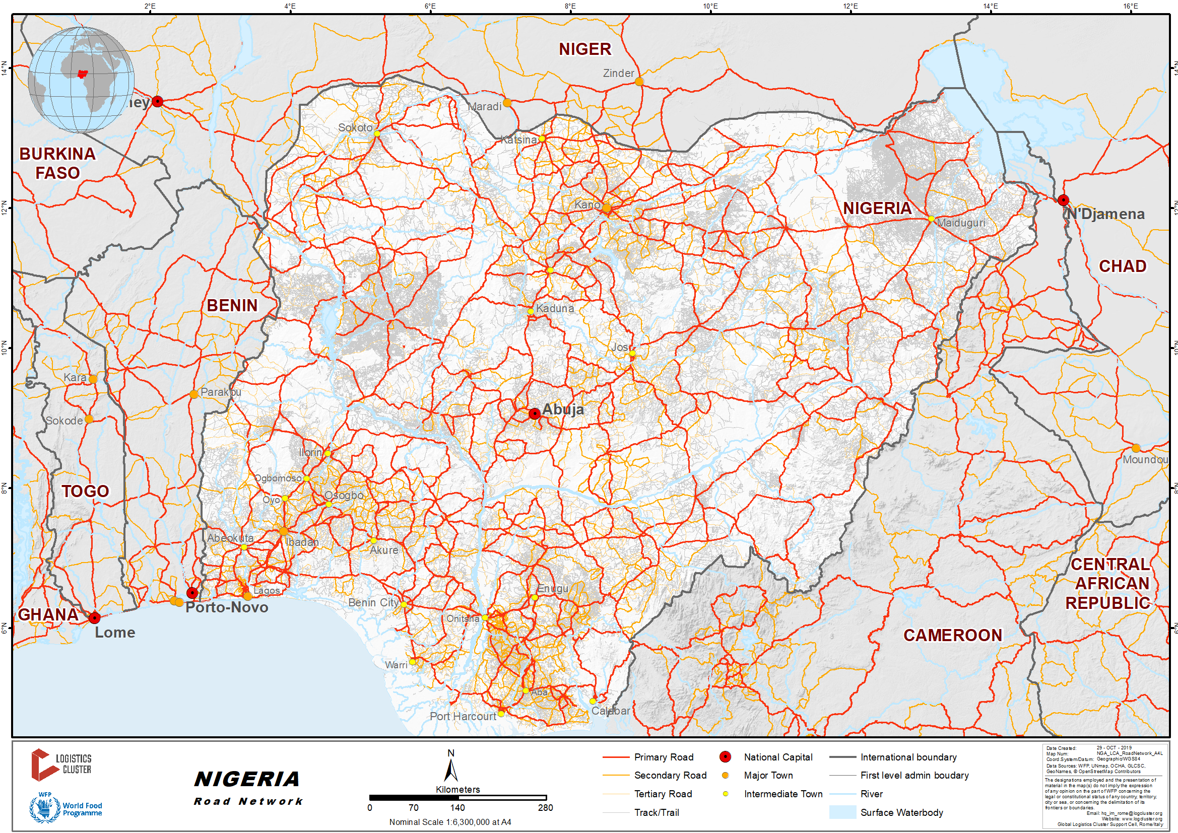
Nigeria has the largest road network in West Africa. According to the Government Infrastructure Concession Regulatory Commission, Nigeria has about 195,000 km of road network of which about 60,000 km are paved (2019).
Most of the major road networks were constructed in the 80s and early 90s. As a result of poor maintenance and low-quality materials used for repairs, the condition of roads is deteriorating. Travelling is very difficult, and sometimes almost impossible in many areas on secondary roads during the raining season due to potholes and eroded, uneven surfaces.
Nigeria’s most important highways run from South to North and were designed to bring produce from the hinterlands to the coast for export and to link the economies of old Northern and Southern Nigeria. These highways are labelled the A1, A2, A3 and A4. All other major roads in the country originate from these four.
In its 2018 budget the Government allocated N295 billion ($ 819mil) for road capital works and maintenance so there are ongoing programs to upgrade and maintain these main thoroughfares.
For more information on government contact details, please see the following link: 4.1 Nigeria Government Contact List
Distance Matrix
|
Distances from Capital City to Major Towns (km) |
||||||||
|
|
Abuja |
Lagos |
Port Harcourt |
Enugu |
Kaduna |
Kano |
Maiduguri |
Bauchi |
|
Abuja |
|
747 |
647 |
475 |
188 |
445 |
853 |
462 |
|
Lagos |
747 |
|
616 |
560 |
897 |
1130 |
1698 |
1206 |
|
Port Harcourt |
647 |
616 |
|
227 |
789 |
1022 |
1367 |
917 |
|
Enugu |
475 |
560 |
227 |
|
614 |
847 |
1142 |
756 |
|
Kaduna |
188 |
897 |
789 |
614 |
|
235 |
804 |
402 |
|
Kano |
445 |
1130 |
1022 |
847 |
235 |
|
564 |
319 |
|
Maiduguri |
853 |
1698 |
1367 |
1142 |
804 |
564 |
|
412 |
|
Bauchi |
462 |
1206 |
917 |
756 |
402 |
319 |
412 |
|
Source: www.distance-cities.com
|
Travel Time from Capital City to Major Towns (Hours) |
||||||||
|
|
Abuja |
Lagos |
Port Harcourt |
Enugu |
Kaduna |
Kano |
Maiduguri |
Bauchi |
|
Abuja |
|
11 |
11 |
7 |
2.5 |
7 |
12 |
7 |
|
Lagos |
11 |
|
9 |
8 |
13 |
15 |
23 |
18 |
|
Port Harcourt |
11 |
9 |
|
4 |
12 |
15 |
21 |
15 |
|
Enugu |
7 |
8 |
4 |
|
8 |
11 |
17 |
11 |
|
Kaduna |
3 |
13 |
12 |
9 |
|
3 |
10 |
6 |
|
Kano |
7 |
15 |
15 |
11 |
3 |
|
8 |
5 |
|
Maiduguri |
12 |
23 |
21 |
17 |
10 |
8 |
|
6 |
|
Bauchi |
7 |
18 |
15. |
11 |
6 |
5 |
6 |
|
Source: www.distancesfrom.com
Road Security
There is a high level of insecurity on Nigerian roads once outside metropolitan areas, with many reports of armed criminals stopping travellers resulting in robbery and kidnappings. The risk is particularly high after dark and on secondary roads where traffic is forced to slow down as a result of poor surface conditions.
Local risk status should be checked with trusted official security forces before attempting road travel and armed escorts are required in many areas as a result of criminal activity.
There is a constant risk of collision as a result of poor road conditions and repair works that result in traffic changing lanes without warning and turning single lane expressways into 2-way traffic at any time.
Numerous police checkpoints can add considerably to travel times and all documentation relating to vehicles and passengers should be in order and carried to avoid further delays at these checkpoints.
Weighbridges and Axle Load Limits
|
Axle Load Limits |
Nigeria |
ECOWAS Transit countries |
|
Truck with 2 Axles |
18 Tons |
18 Tons |
|
Truck with 3 Axles |
26 Tons |
26 Tons |
|
Truck with 4 Axles |
31 Tons |
31 Tons |
|
Semi-trailer with 3 Axles |
26 Tons |
26 Tons |
|
Semi-trailer with 4 Axles |
38 Tons |
38 Tons |
|
Semi-trailer with 5 Axles |
43 Tons |
43 Tons |
|
Semi-trailer with 6 Axles |
51 Tons |
51 Tons |
|
Truck & Drawbar Trailer with 4 Axles |
38 Tons |
38 Tons |
|
Truck & Drawbar Trailer with 5 Axles |
46 Tons |
46 Tons |
|
Truck & Drawbar Trailer with 6 Axles |
59 Tons |
59 Tons |
|
Truck & Drawbar Trailer with 7 Axles |
64 Tons |
64 Tons |
It should be noted that weighbridges are rarely used and trucks are often overloaded.
Road Class and Surface Condition
|
Classification |
|
|
Class: TR |
TRUNK ROADS (A = Federal, B = State and C = Local govt. roads resp.) |
|
Class: BR |
BRANCH ROUTES |
|
Class: BS |
BORDER SPUR |
|
Class: SR |
SECONDARY ROUTES |
|
Class: (A/C) |
ASPHALTIC CONCRETE ROADS |
|
Class: (E/R) |
EARTH ROADS |
|
Class: (S/D) |
SURFACE DRESSED ROADS |
Trunk Road “A”
Trunk Road “A” forms the skeleton of the national road grid. It cuts across regional boundaries in the country. This class of road is constructed, maintained and financed by the Federal Government through the Federal Ministry of Works and Housing.
Trunk Road “B”
Trunk Road “B” is the second category of main roads in Nigeria. It links the major cities within States. These roads are financed by the State governments. They are tarred roads.
Trunk Road “C”
Trunk Road “C” are local feeder roads constructed and maintained by the Works Department of local government authorities in Nigeria. This class of road is usually untarred and seasonal in nature.
2.3.1 Nigeria Seme Land Border Crossing
Overview
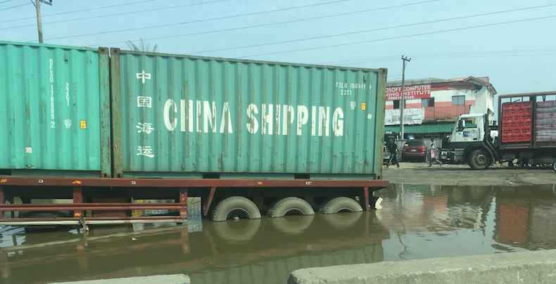
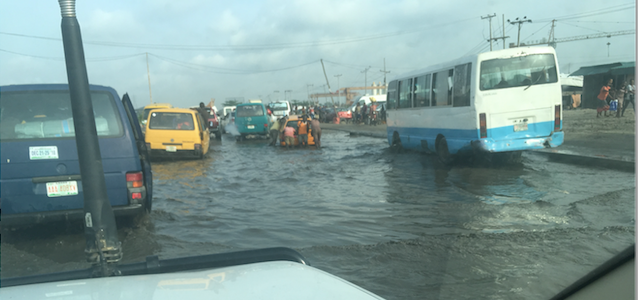
There are no particular obstacles at the border, however sections of the road to Lagos are very bad with deep potholes, muddy and flooded sections and frequently, stuck and broken-down trucks, buses and cars that result in gridlock.
|
Border Crossing Location and Contact |
|
|
Name of Border Crossing
|
Nigeria: Seme Benin: Kreke |
|
Province or District |
Badagry LGA, Lagos State |
|
Nearest Town or City with Distance from Border Crossing |
Badagry 15 km |
|
Latitude |
6 22’ 55’’ N |
|
Longitude |
2 43’20’’ E |
|
Managing Authority / Agency |
Nigeria Customs Services |
|
Contact Person |
|
|
Travel Times |
|
|
Nearest International Airport |
Murtalla Mohamed Int’l Airport, Ikeja 33 km Truck Travel Time: subject to traffic congestion, poor road conditions and multiple check points: up to half day (5 hrs+) Car Travel time: Approximately 4 hours |
|
Nearest Port |
Apapa 55 km Truck Travel Time: subject to traffic congestion, poor road conditions and multiple check points: half day (6 hrs+) Car Travel time: 3 – 5 hours |
|
Nearest location with functioning wholesale markets, or with significant manufacturing or production capacity |
Lagos |
|
Other Information
|
There are fuel stations on the route, no weigh bridges (or need for them). The road is very rough and crowded on the Nigeria side, much better condition on the Benin side. |
|
Hours of Operation |
|
|
Mondays |
24/7 |
|
Tuesdays |
24/7 |
|
Wednesdays |
24/7 |
|
Thursdays |
24/7 |
|
Fridays |
24/7 |
|
Saturdays |
24/7 |
|
Sundays |
24/7 |
|
National Holidays |
24/7 |
|
Seasonal Constraints |
During peak rainy season (June, July, August) an already difficult access road from Lagos may becomes almost impassable |
Daily Capacity
Trucks and cars use the same lane. Trucks generally park and wait in a separate layby lane until dark when Nigerian truck drivers prefer to travel. Daily average for trucks through the border is 55 trucks (50 Benin to Nigeria, 5 Nigeria to Benin). There is little formality for cars or pedestrians crossing the border and most inspections of cars entering Nigeria are carried out on the many formal and informal checkpoints present for the first 15 km on the road to Lagos.
Customs Clearance
Importation of humanitarian goods: For more information on customs in Nigeria, please see the following link: 1.3 Nigeria Customs Information
Exportation of humanitarian goods: the requirements are Packing list, Commercial Invoice, Waybill and Export Permit from Customs. Some Items may also require approval from the Presidency.
Other Relevant Information
For trucks leaving Nigeria, provided all papers are in order, waiting time is generally less than 1 hour to obtain clearance to cross the border into Benin.
For trucks entering Nigeria, Customs operate an electronic scanner that will facilitate clearance in less than an hour. In the event it is not operating manual inspections may take up to 2 hours. There is no delay on the Benin side.
While trucks attract official attention, cars and pedestrians cross the border at will with little or no attention from customs or immigration.
For more information on government contact details, please see the following link: 4.1 Nigeria Government Contact List
Photos of Lagos-Seme road:
2.3.2 Nigeria Ngala Land Border Crossing
Overview
The border is busy with no particular obstacles. It is operated by the Nigeria Customs Service. Updates on road conditions and accessibility should be obtained from the local office of the National Union of Road Transport Workers (NURTW). At time of writing (June 2019) all trucks to the border were required to travel the road from Maiduguri to the border in escorted convoy with an overnight stopover in Gajibo before travelling to the border, where the commercial trucks enter a bonded area and their Pre-Arrival Assessment Report (PAAR) issued by customs in Maiduguri are checked by the military before travelling the remaining short distance to cross the border. Trucks carrying humanitarian cargo go through a similar process.
There is no fuel available at the border or en route. There is very little secure storage available at the border.
Accommodation may be available for registered humanitarian agencies at the UN humanitarian Hub: www.humanitarianbooking.wfp.org
|
Border Crossing Location and Contact |
|
|
Name of Border Crossing
|
Nigeria: Ngala Cameroon: Fotokol |
|
Province or District |
Borno State, Gomboru Ngala Local Government Area (LGA) |
|
Nearest Town or City with Distance from Border Crossing |
Gambaru, on the border |
|
Latitude |
12.372742 |
|
Longitude |
14.207570 |
|
Managing Authority / Agency |
Nigeria Customs Service (NCS) |
|
Contact Person |
Ayomide Adisa Contact: 0706 59 8525 |
|
Travel Times |
|
|
Nearest International Airport |
Maiduguri 200 km Truck Travel Time: 8 (dry season) - 16 (wet season) Car Travel time 6 hrs |
|
Nearest Port |
Lagos 1700 km Truck Travel Time: 40hrs (dry season) - 50 (rain) Car Travel time: 30 hrs |
|
Nearest location with functioning wholesale markets, or with significant manufacturing or production capacity |
Kano 730 km Truck Travel Time: 20 hrs (dry) - 30 hrs (rain) Car Travel time: 15 hrs |
|
Other Information
|
Road between Maiduguri and border requires travel permit for cargo and may require escort due to hostilities. |
|
Hours of Operation |
|
|
Mondays |
0800 – 1800 |
|
Tuesdays |
0800 – 1800 |
|
Wednesdays |
0800 – 1800 |
|
Thursdays |
0800 – 1800 |
|
Fridays |
0800 – 1200 |
|
Saturdays |
0800 – 1200 |
|
Sundays |
0800 – 1200 |
|
National Holidays |
May be closed on public holidays. Confirmation should be obtained from local office (contact details above) |
|
Seasonal Constraints |
August, September, October rain season renders the parts of the road from Maiduguri to the border impassable. Transport of goods should not be planned during these months. |
Daily Capacity
Very busy. All traffic uses same crossing lane. Capacity is limited by hours of operation and time taken to inspect vehicles. Around 50 to 200 trucks per day is normal.
Customs Clearance
Nigerian Customs Service (NCS) operate the customs post. Standard documentation is required (see below). Without prior arrangement customs will not be available on weekends or public holidays.
For more information on customs in Nigeria please see the following link: 1.3 Nigeria Customs Information
Exportation of humanitarian goods: the requirements are: Packing list, Commercial Invoice, Waybill and Export Permit from Customs. Some items may also require approval from the Presidency.
Other Relevant Information
Very busy border, functions as per regular Nigerian Customs Service rules and regulations, Pre-Arrival Assessment Report (PAAR) issued by customs in Maiduguri are checked by the military before crossing the border.
For more information on government contact details, please see the following link: 4.1 Nigeria Government Contact List
2.3.3 Nigeria Katsina Land Border Crossing
Overview
Available facilities are examination bay, scanning machine and generating plant to power the scanning machines. There are no obstacles as long as the vehicle document is correct.
Traffic is relatively heavy especially on market days. All vehicles use the same lane. Traffic leaving and entering approximately the same.
Customs clearance is for cargo or merchandize goods. This involves examination to determine whether what is being carried corresponds to the cargo declaration in quantity and value.
These goods are generally in 2 categories:
- Heavy-duty trucks and trailers
- Cars and light vehicles with small quantities of goods for petty traders.
The former requires Form M application and presentation of Single Goods Declaration (SGD) as evidence of payment of duty. The latter are assessed by valuation unit at the HQ and given a specific amount to pay as duty depends on the type of goods and the type of vehicle used for conveyance. The carriers also require laissez passer if it’s a foreign registered vehicle. This involves a bond to make sure that after discharging the vehicle comes back and crosses to the other side.
The only waiting time is the time it takes to finish examination. The examination is conducted jointly with other relevant government agencies.
|
Border Crossing Location and Contact |
|
|
Name of Border Crossing |
Nigeria: JIBIA |
|
Province or District |
Katsina State |
|
Nearest Town or City with Distance from Border Crossing |
JIBIA 55.2 KM 1 h 5 min |
|
Latitude |
7°13'18.3"E |
|
Longitude |
13°05'54.3"N |
|
Managing Authority/Agency |
|
|
Contact Person |
|
|
Travel Times |
|
|
Nearest International Airport |
Mallam Aminu Kano International (MAKIA) Airport Distance 230 km Truck Travel Time: 6 hrs Car Travel time: 3 hrs 30 min Katsina airport (see note below table) 50.4 km Truck Travel Time: 1 hr Car Travel time: 57 min |
|
Nearest Port |
Lagos 1,154 km Truck Travel Time: 18 hrs 36 min Car Travel time: 10 hrs |
|
Nearest location with functioning wholesale markets, or with significant manufacturing or production capacity |
Kano Distance 230 km Truck Travel Time: 6 hrs Car Travel time: 3 hrs 30 min |
|
Other Information |
Good road network, 4-star hotel accommodation, fuelling stations and weighing bridges available en route. |
It should be noted that although Katsina has an ‘International’ airport, all but a handful of annual flight volumes are domestic, the only contributor to international flight volume is for Hajj (annual Muslim pilgrimage to Mecca) therefore there are no permanent customs or immigration services.
|
Hours of Operation (Border crossing) |
|
|
Mondays |
12 hrs |
|
Tuesdays |
12 hrs |
|
Wednesdays |
12 hrs |
|
Thursdays |
12 hrs |
|
Fridays |
12 hrs |
|
Saturdays |
12 hrs |
|
Sundays |
12 hrs |
|
National Holidays |
May be closed on public holidays. Confirmation should be obtained from local office (contact details above) |
|
Seasonal Constraints |
Winter months December - February, rainy season May -September |
Daily Capacity
Traffic is relatively heavy especially during market days as all moving vehicles uses the same route/lane. Traffic leaving or entering is almost the same.
Customs Clearance
Nigerian Customs Service (NCS) operate the customs post. Standard documentation is required (see below).
Importation of Humanitarian Goods: for more information on customs in Nigeria, please see the following link: 1.3 Nigeria Customs Information
Exportation of Goods: Exportation of humanitarian goods: the requirements are Packing list, Commercial Invoice, Waybill and Export Permit from Customs. Some Items may also require approval from the Presidency.
Other Relevant Information
For more information on government contactdetails, please see the following link: 4.1 Nigeria Government Contact List