2.3 Kazakhstan Road Network
Kazakhstan Road Network
For information on Kazakhstan Road Network contact details, please see the following link:
4.1 Kazakhstan Government Contact List
For information on Kazakhstan Motor Roads Committee Regulations, please see the following document:
Kazakhstan Regulation on Motor Roads Committee Information
Note: The information provided in the attached documents, which has been taken from the old DLCA, does not match the structure of the new LCA and is therefore provided separately.
The thriving east-west trade that once spanned Central Eurasia along the famed Silk Road may soon be restored to its former glory thanks to growing transport and trade links being rolled out. Central Asian countries have been working closely together to construct transport corridors, promote energy security, and remove trade barriers. They have shed outdated trade policies and adopted new rules to increase commerce. Trade between East and West is booming again, the government has decided it needs to upgrade its infrastructure. A country of vast expanses, and huge distances, it is a major logistical challenge for those trying to do business here, it is the largest landlocked country in the world. But a new highway is under construction that will span the entire country and replace many of the bumpy back roads that make travel here such a chore. The road from Almaty, the largest city and former capital, flows through the mountain of Eastern Kazakhstan, a rural area which is believed to have large economic potential with huge oil, gas and mineral reserves. To make it more accessible for businesses, Kazakhstan plans to spend about $19 billion on transport infrastructure by 2014, especially on links from China to Europe that could help revive towns like Taraz..
Distance Matrix
|
Distances from Capital City to Major Towns (km) |
||||
|---|---|---|---|---|
|
|
Astana |
Karagandy |
Shymkent |
Almaty |
|
Astana |
1173.21 km |
997.79 km |
975.26 km |
|
| Karagandy | 1173.21 km | 1421.05 km | 1839.48 km | |
| Shymkent | 997.79 km | 1421.05 km | 608.33 km | |
| Almaty | 975.26 km | 1839.48 km | 608.33 km | |
Road Security
Level: Good
Roads in Kazakhstan are in poor repair in rural areas. Poor signage is common. Street lighting, especially on side streets, may be turned off at night. Drivers often ignore lane markings. Potholes are common, and are often dangerously deep. Pedestrians frequently dart out in front of cars. Visitors should drive defensively at all times as many local drivers do not follow traffic laws. Special caution should be taken if driving at night. Road rage can be a problem, especially in and around Almaty, and a non-confrontational response to such behavior is strongly recommended. Accidents involving severe injury and/or death are common. Traffic police have reportedly stopped cars to extort bribes on main city streets and at periodic checkpoints on major highways.
The road between Almaty and Bishkek, Kyrgyzstan, is especially
treacherous at night or during poor weather. U.S. citizens and
other travelers have been killed in traffic accidents on that road,
and travel at night or during poor weather should be avoided.
Travelers should be particularly careful when using public
transportation and taxis. Buses tend to be very crowded and can be
unsafe and unreliable. Due to the danger of theft or assault,
travelers should be selective regarding which taxi they contract
and always avoid entering a cab that already contains persons other
than the driver.
Kazakhstan has a zero-tolerance policy for driving under the
influence of alcohol. A driver may be detained by police and
convicted of drunk driving for driving a vehicle after consuming
one drink of alcohol, regardless of whether the driver is actually
intoxicated. ( Source : http://travel.state.gov )
Weighbridges and Axle Load Limits
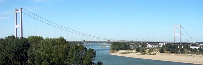
The Semei Bridge is a gravity-anchored suspension bridge that crosses the Irtish river in Semei, Kazakhstan. It has a main span of 750 meters and a total length of 1086 m. It was built between 1998 and 2001 and is currently in use by road traffic.
| Type | LCA Country | Kyrgystan |
|---|---|---|
| Truck with 2 axles | 11 : 15 Tons | 11 : 17 Tons |
| Truck with 3 axles | 15 : 20 Tons | 15 : 24 Tons |
| Truck with 4 axles | 18 : 32 Tons | 18 : 32 Tons |
| Semi-trailer with 3 axles | 36 Tons | 36 : 44 Tons |
| Semi-trailer with 4 axles | 36 Tons | 36 : 44 Tons |
| Semi-trailer with 5 axles | 36 Tons | 36 : 44 Tons |
| Semi-trailer with 6 axles | 36 Tons | 36 : 44 Tons |
| Truck & drawbar trailer with 4 axles | 36 Tons | 36 : 44 Tons |
| Truck & drawbar trailer with 5 axles | 36 Tons | 36 : 44 Tons |
| Truck & drawbar trailer with 6 axles | 36 Tons | 36 : 44 Tons |
| Truck & drawbar trailer with 7 axles | 36 Tons | 36 : 44 Tons |
Road Class and Surface Conditions
Basic indicators of status of public roads in the Republic of Kazakhstan (January to December 2012):
| Description | Measuring unit | Status | ||
|---|---|---|---|---|
| Nation-wide | Regional and district | Total | ||
| Length of roads in total in the RK: | km | 23 484 | 73 932 | 97 416 |
| By technical category | ||||
| I | km | 1 069 | 72 | 1 141 |
| II | km | 4 016 | 781 | 4 797 |
| III | km | 16 505 | 14 564 | 31 069 |
| IV | km | 1 808 | 46 571 | 48 379 |
| V | km | 86 | 11 944 | 12 030 |
| By types of road topping | ||||
| cement-concrete | km | 178 | 178 | |
| asphalt-concrete | km | 10 398 | 7 731 | 18 129 |
| black macadam | km | 4 012 | 11 704 | 15 716 |
| black gravel | km | 7 071 | 18 990 | 26 061 |
| black top-soil | km | 34 | 593 | 627 |
| gravel-macadam | km | 1 684 | 24 672 | 26 356 |
| top-soil | km | 107 | 10 242 | 10 349 |
| By condition: | ||||
| good | % | 30 | 16 | 19 |
| satisfactory | % | 49 | 47 | 47 |
| unsatisfactory | % | 21 | 37 | 34 |
| Encompassed with all types of repair, including: | ||||
| building and reconstruction | km | 1 621 | 196 | 1 817 |
| capital repair | km | 65 | 456 | 521 |
| medium repair | km | 1 100 | 2 971 | 4 071 |
| current repair and maintenance | km | 21 798 | 73 280 | 95 078 |
For information on Kazakhstan Road Network additional European Route details, please see the following documents:
Kazakhstan Road Network European Route Information
Note: The information provided in the attached documents, which has been taken from the old DLCA, does not match the structure of the new LCA and is therefore provided separately.