2.2 Guinea Aviation

Key airport
information may also be found
at: World Aero Data
website information on Guinea
Conakry
The Guinean Authority of Civil Aviation (AGAC) is the competent authority in Guinea for aviation safety and airport security. The National Air Navigation Agency ensures the safety, regularity and efficiency of public air traffic in the Republic of Guinea, management and exploitation of domestic aerodromes. There is one international airport in Conakry, 13 national airfields and three private airfields: in Beyla (exploited by Rio Tinto) Kawaas and Sangaradi (exploited by the CBG). Some of these airfields are not operational. There is no national carrier but there are projects on paper to create one in the near future. Currently there are four private companies flying nationally on charter basis which are Eagle Air, Probiz, SAS Guinea and Con Air in addition to the humanitarian flights by UNHAS and Aviation without Borders.
The airport of Conakry is managed by SOGEAC.
Eagle Air Guinea SA, which only offers charter flights from its base in Conakry, has 3 planes. Two airplanes of LET 410 UVP 6T MTOW with:
- Passenger Capacity: 12 (Long Distance) or 15 (Short Distance)
- Cargo Capacity: 1.25 tons
- Cargo Door: 1.25 m x 1.45 m
- Range: 412 nm / 760 km
- Speed: 164 knots / 300 KPH
- Max Altitude: 10,000 feet
The third airplane, a Mitsubishi MU-2B-60 Marquise with:
- Passenger Capacity: 6 - any distance
- VIP Aircraft: Pressurized and Air Conditioned, Air Ambulance Equipped
- Range: 1,000 nm / 1,852 km
- Speed: 256 knots / 475 KPH
- Max Altitude: 28,000 feet.
An Indicative cost per destination/weight/volume is approximately:
- LET 410 Aircraft: US $1,950.00 / Hour / 150 knots Flight Plan Speed for total ‘Trip Time’
- Mitsubishi MU-2B-60: US $1,950 / Hour / 200 knots Flight Plan Speed for total ‘Trip Time’.
Additional Costs include:
- Permits
- Airways
- Landing
- Handling
- Night Landing
- Passenger Taxes
- Terminal Taxes
- Any additional Airport Fees
Eagle Air Guinea SA offers domestic flights to:
- Conakry
- Siguiri
- Kankan
- Kissidougou
- N’Zerekore
- Kamsar
and regional flights to:
- Sierra Leone
- Liberia
- Ivory Coast
- Ghana
- Burkina Faso
- Mali
- Guinea Bissau
- Banjul, Gambia
- Senegal
Its Maintenance Director is based in Conakry. The company is erecting its own hangar on Conakry Airfield, next to theSOMCAG compound. All line maintenance and annual inspections are carried out in Conakry. Heavy Inspections are carried out in Bratislava, Europe (LET 410) and Fayetteville Aviation Inc. Fayetteville TN 37334 (MU2) in the USA. Compliance with an A.D. Inspection, an 8,500 Hours Check, new props, Hot Section Engines, New Interior and New Paint. It is worth mentioning that Eagle Air has its own FAA and DNAC "Approved Advanced Training Device" (Simulator) and an MU2 Training Device (Actual nose of an Aircraft).
UMS Aviation is capable to adjust a solution to any kind of specific demand, from a one time charter to a dedicated airplane:
- Monthly blocked hours
- Dedicated aircraft
- Remote base operation
For more information on aviation in Guinea, please see the following links:
4.5 Guinea Airport Company Contact List
Procedures for Foreign Registered Aircraft
The application procedure for traffic rights at the International Conakry airport (which are the same for chartered flights and humanitarian flights) are as follows:
- 72 hours before the flight departure: A letter signed by the Representative of the concerned Organization is to be sent to the Civil Air Aviation in Guinea (Direction Nationale de l’Aviation Civile). The letter should be signed and returned by the CAA. The following information should be specified in the letter: Registration number of the aircraft, flight number, call sign, the pilot’s license, and the purpose of the flight, specifying also the name of the company and the name and address of the chatterer. Also to be attached is a copy of the insurance certificate and a copy of the airworthiness certificate.
- As soon as possible when the charter contract is confirmed with a schedule, the air company / the operator of the aircraft should send an SITA telex requesting a landing permit number and over flight permit to Conakry. Like all international airports, Conakry has a SITA address. The request coming from an air company has to contain the exact same information as the letter to the Civil Air Aviation in Guinea, specifying: Type of freight, type of context (for instance, for emergency humanitarian aid), name and address details of the chatterer of the aircraft and the consignee at the destination.
Usually the answer from the Civil Air Aviation will be ready within 24 hours after the SITA message has been received by the Civil Air Aviation. If there are problems getting the permission the charterer should ask the consignee - the humanitarian organisation at the destination - to take an appointment with the Civil Air Aviation to find out what are the problems and discuss them with the Guinean authorities.
For charted flights carrying VIP passengers, additional clearance should be requested at the Ministry of Foreign Affairs.
Normally for chartered flights you need to send a pre-advice to SOGEAC to book the handling, minimum 12 hours before ETD of the flight.
For information on Guinea procedures, please directly contact the Directorate of the National Aviation. Contact details can be found in the 4.5 Guinea Airport Company Contact List.
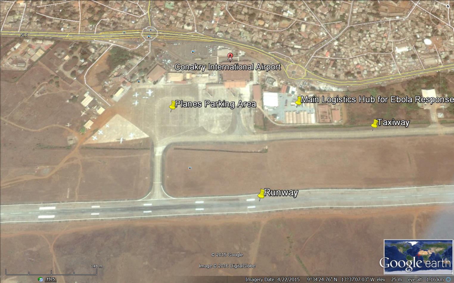
2.2.1 Guinea Conakry Gbessia International Airport
Conakry airport is situated at the end of the peninsula on the North East part of Conakry city about 13 km from downtown. The airport is connected to the town with a new 9 km long highway arriving at the bridge of 8th November. The suburbs, Matoto, are situated north of the airport area. There is also a military casern next to the airport.
| Location Details | |||
|---|---|---|---|
| Country | Republique de Guinée | Latitude | 9.406878 |
| Province / District | Basse Guinée | Longitude | -13.61865 |
| Town or City (Closest) | Conakry | Elevation (ft and m) | 71 ft / 25 m |
| Airfield Name | Conakry Gbessia | IATA and ICAO Codes | GUCY / CKY |
| Open From (hours) | 00:00 | Open To (hours) | 24:00 |
Runways
The parking space is wide and there are good security conditions. The airport is well equipped (light, markings on the ground, tie down facilities, etc). Maintenance and unloading areas are available. Fuel access is located on the parking area so aircraft can taxi directly to the location for refueling. There are five possible fuel connections; Apron surface & strength: 25 m Concrete B-747. Surface parking & strength: Concrete + Asphalt to support B747. No use of aircraft stands ID signs. Taxi way guidelines and visual docking/parking guidance system of aircrafts stands. Runway and taxi way markings and lights.
|
Runway #1 |
|
|---|---|
|
Runway Dimensions |
3,300 m x 45 m |
|
Orientation |
06/24 |
|
Surface |
Concrete |
Helicopter Pad(s)
There is no Helicopter Pads at the airport; nevertheless two areas are used as such in the planes parking area facing the domestic terminal.
Airport Infrastructure Details
The airfield is well maintained and so is the equipment.
|
Customs |
Yes |
JET A-1 fuel |
Yes |
|---|---|---|---|
|
Immigration |
Yes |
AVGAS 100 |
N/A |
|
Terminal Building |
Yes |
Single Point Refueling |
No |
|
Passenger Terminal |
Yes |
Air Starter Units |
Yes |
|
Cargo terminal |
Yes |
Ground Power (mobile) |
Yes |
|
Pax transport to airfield |
Yes |
Ground Handling Services |
Yes |
|
Control Tower |
Yes |
Latrine Servicing |
Yes |
|
Weather Facilities |
Yes |
Fire Fighting Category (ICAO) |
Yes: Cat 9 |
|
Catering Services |
Yes |
De-icing Equipment |
N/A |
|
Base Operating Room |
Yes |
Parking Ramp Lighting |
Yes |
|
Airport Radar |
Yes |
Approach & Runway Lights |
Approach Lights: N/A Runway lights: Yes |
|
NDB |
Yes |
VOR |
Yes |
|
ILS |
Yes |
|
Passenger and Cargo Performance Indicator
In order to increase the airport's performance, SOGEAC is planning to build a taxi way which will double the capacity of the airport as the planes will be able to taxi during landing or take-off instead of using the only runway available in the airport.
|
Performance for 2014 |
Annual Figures |
Monthly |
Daily |
|---|---|---|---|
|
Total aircraft movements |
N/A |
N/A |
N/A |
|
Total passengers |
1,500,000 |
125,000 |
4,166 |
|
Total capacity of the airport (metric tonnes) |
35,000 mt |
29,167 |
972 |
|
Current activity of the airport (metric tonnes) |
35,000 mt |
||
|
Current use by Humanitarian flights (UNHAS) |
N/A |
In order to improve the airport services and attract more air companies (especially cargo), SOGEAC is working on obtaining the RA3 which is a cargo-handling entity located in a third country that is validated and approved as such on the basis of an EU aviation security validation. The RA3 must ensure that security controls, including screening, are applied to all EU/EEA bound consignments and protected from interference. The RA3 and the KC3 checklist is the instrument used by the EU aviation security validator for assessing the level of security applied to EU/EEA bound air cargo or air mail or under the responsibility of the entity seeking designation as a RA3 or KC3. The completed checklist is signed by the EU aviation security validator and, where applicable, commented by the validated entity. If the EU aviation security validator concludes that the entity has succeeded in the complying with the objectives referred to in the checklist, a validation report shall be given to the validated entity. The validation report shall state that the entity is designated Third Country EU aviation security validated Regulars Agent (RA3) or Known Consignor (KC3). The audit will be conducted by Air France. This is the first step to obtain the ACC3 = ‘Air Cargo or Mail Carrier operating into the Union from a Third Country Airport’. It is required by the European Union (including Iceland, Norway and Switzerland) for carriers to fly air cargo into or through the EU. As from 1 July 2014, carrier stations in third countries must have a Security Validation in order to acquire or maintain their ACC3 designation. This validation needs to be reissued every five years.
Airport Operating Details
|
Operating Details |
|||
|---|---|---|---|
|
Maximum sized aircraft which can be offloaded on bulk cargo |
AN 124 100/200 |
||
|
Maximum sized aircraft that can be offloaded on pallet |
747 cargo |
||
|
Total aircraft parking area (m²) |
N/A |
||
|
Storage Area (mt) |
50,000 |
Cubic Meters (m³) |
N/A |
|
Cargo Handling Equipment Available (Yes / No) |
Yes |
If "Yes" specify below |
|
|
Elevators / Hi Loaders (Yes / No) |
Yes |
Max Capacity (mt) |
45 mt |
|
Can elevators / hi loaders reach the upper level of a B747 (Yes / No) |
Yes |
||
|
Loading Ramps (Yes / No) |
Yes on request |
||
Storage Facilities
There are two 40’ Reefer containers available at the airport; one is fixed at +12 and the other is fixed at +4. No negative temperatures are available. SOGEAC is planning a project to increase the storage capacity to 300,000 mt within two years’ time.
Airfield Cost
Navigation Charges
The navigation charges are distinguished by the charges to be paid to the Guinean National Navigation Authority for flights level below 100 which is calculated as following equation: √weight of the plane in mt / 1 x US $65. In addition to that there are the regional navigation charges to be paid to the Flight Information Region based at Roberts International Airport in Monrovia, Liberia for flights level above 100. The landing charges at Gbessia International Airport are detailed per metric ton as each metric ton has a different amount for charging. Airspace is divided into lower and upper airspace and into Flight Information Regions (FIRs), which can, as required, encompass Terminal Control Areas (TMAs) or Upper Control Areas (UTAs). An FIR is an airspace with specific dimensions, in which an information service and an alert service are provided. The Roberts FIR TMA extends 40 nm north of Conakry and 99 nm south of Monrovia. The Roberts FIR is a dismemberment of the Dakar FIR. It was established in January 1975 by Guinea, Liberia and Sierra Leone, which decided to manage their airspace jointly. The FIR was named after Roberts International Airport (also known as Robertsfield), which hosted the headquarters at its creation. The headquarters was transferred to Freetown in June 1990 because of the war in Liberia. It has been based in Conakry since June 1997 as a result of the war in Sierra Leone.
|
Aircraft Weight - MTOW (kg) |
Navigation (per journey) USD - $ |
Landing USD - $ |
Night Landing USD - $ |
Night Take-Off USD - $ |
Parking USD - $ |
Handling Charges USD - $ |
|
|---|---|---|---|---|---|---|---|
|
0 |
7,000 |
FIR rates: $0.81 x distance (km) |
4.387 – 30.624 |
350.18 |
350.18 |
1.095 / hour |
42.72 |
|
7,001 |
136,000 |
FIR rates: $0.81 x distance (km) |
30.634 – 1,236.215 |
350.18 |
350.18 |
1.095 / hour |
42.72 |
|
136,001 |
and over |
FIR rates: $0.81 x distance (km) |
1,236.215 - |
350.18 |
350.18 |
1.095 / hour |
42.72 |
|
Note 1: Night landing hours are between 00:00 – 24:00 hours
|
|||||||
Fuel Services Charges
The Société de Manutention de Carburant Aviation de Guinée (SOMCAG) is the sole provider of the fuel services at the airport. The price of Jet A-1 varies if it is for a domestic flight or an international flight.
|
September 2015 |
Price per Unit USD - $ |
|---|---|
|
Jet A-1 Domestic flights Jet A-1 International flights |
1.231 / litre 0.95 / litre |
|
Avgas |
N/A |
Cargo Terminal Charges
For all the cargo terminal charges, it is preferable to negotiate directly with SOGEAC and obtain a quotation. Other charges that could be included are:
- Passenger Service Charges of $25 from Africa to $30 Out of Africa
- Passenger Security Charge of $5
- Infrastructure Charge of $25 per passenger
- Passengers Transportation of $40 per flight
- Toilets servicing of $97.32
- GPU: the first hour is $192.09 and is $96.04 from the second hour
- ASU is $128.06 per start
- Baggage Recognition of $250
|
Import |
Rate US$ / kg |
|---|---|
|
Handling Charge per kg |
130.88 / mt |
|
Break Bulk Fee |
130.88 /mt |
|
Diplomatic Mail |
Free |
|
Strong Room – per consignment |
N/A |
|
Cold Storage Fee |
N/A |
|
Delivery outside normal working hours |
20% |
|
Preparation of substitute AOA – Invoice – Receipt |
N/A |
|
Storage per kg per day – Grace period? hours |
5 days |
|
Export |
Rate US$ / kg |
|
Handling charges – Unpalletized cargo |
130.88 / mt |
|
International Air WayBill |
N/A |
|
Local Air WayBill |
N/A |
|
Air Way Bill Amendment - Cancellation |
N/A |
|
Air Way Bill Documentation |
N/A |
|
Diplomatic Mail |
Free |
|
Storage charges per kg per day |
100,000 GNF / 100 kg |
Air-bridge Charges
To be negotiated directly with SOGEAC.
Security
The security of the airport premises is ensured by the Gendarmerie while the National Police is in charge of the safety of the interior. The level of security procedures is fair.
Companies Available
For information on Guinea Conakry Airport contacts, please see the following link: 4.5 Guinea Airport Company Contact List
Information on some aviation service providers can be found at: http://www.azfreight.com/
2.2.2 Guinea Boké National Airfield
Boké airfield is a private airfield without any
facilities at the site and is considered as closed by the National
Navigation Authority. It is located 3 km away from Boké. There is
an old abandoned building within the airfield premises with one
security guard. There is no Guinean CAA activity but the airfield
is useful for helicopter landing. It is imperative to advise the
national police and the fire-fighting department 72 hours before
any activity.
|
Airport Details |
|||
|---|---|---|---|
|
Country |
Guinea |
Latitude |
10.95 |
|
Province / District |
Boké |
Longitude |
-14.3 |
|
Airport Name |
Boké |
Elevation (ft and m) |
164 ft / 54 m |
|
IATA & ICAO codes |
GUOK |
Surface |
Compact |
|
Town or City (closest) |
Boké |
Runway Condition |
Bad |
|
NGO / UN (on ground) |
WFP |
Passenger / Cargo Security Screening (Yes / No) |
No |
|
Runway Dimension |
1,500 m x 25 m |
Ground Handling (Yes / No) |
No |
|
Refueling Capacity |
n/a |
Runway Lighting (Yes / No) |
No |
|
Runway Heading |
02/20 |
Fire Fighting Equipment (Yes / No) |
No |
|
Air Traffic Control (Yes / No) |
No |
Windsock (Yes / No) |
No |
|
Weather Information (Yes / No) |
No |
Aircraft Parking space (Yes / No) |
No |
|
Navigation Aids (Yes / No) |
No |
Perimeter fencing (Yes / No) |
No |
Fuel Service Charges
Fuel for airplanes is not available at Boké airfield.
Royalties / Non Objection Fees (NOFs)
There are no royalties to be paid at Boké airfield.
For information on Guinea Airport contacts, please see the following link: 4.5 Guinea Airport Company Contact List
2.2.3 Guinea Fria National Airfield
Fria Katouroun airfield is 2 km away from the town of Fria. It is considered closed by the National Navigation Authority and has no Guinea CAA activity but it can be useful for helicopter landing.
|
Airfield Details |
|||
|---|---|---|---|
|
Country |
Guinea |
Latitude |
10.35083 |
|
Province / District |
Boké / Fria |
Longitude |
-13.5524 |
|
Airfield Name |
Fria |
Elevation (ft) |
499 ft / 152.1 m |
|
IATA & ICAO codes |
GUFA |
Surface |
Concrete |
|
Town or City (closest) |
Fria |
Runway Condition |
Bad |
|
NGO / UN (on ground) |
WFP |
Passenger / Cargo Security Screening (Yes / No) |
No |
|
Runway Dimension (M) |
1600 m / 40 m |
Ground Handling (Yes / No) |
No |
|
Refueling Capacity |
N/A |
Runway Lighting (Yes / No) |
No |
|
Runway Heading |
06/24 |
Fire Fighting Equipment (Yes / No) |
No |
|
Air Traffic Control (Yes / No) |
No |
Windsock (Yes / No) |
No |
|
Weather Information (Yes / No) |
No |
Aircraft Parking space (Yes / No) |
Yes |
|
Navigation Aids (Yes / No) |
No |
Perimeter fencing (Yes / No) |
No |
Fuel Services Charges
Fuel is not available at Fria airfield.
Royalties / Non Objection Fees (NOFs)
There are no royalties or fees to be paid at Fria airfield.
For information on Guinea Airport contacts, please see the following link: 4.5 Guinea Airport Company Contact List
2.2.4 Guinea Kamsar National Airfield
The airfield called Kawass is around 10 km distant from the Kamsar Port. This airfield is mainly used by the Guinean Bauxite company (CBG) therefore the movement on same roads might be restricted as considered private roads. There is no CAA activity but it can be useful for helicopter landing.
|
Airfield Details |
|||
|---|---|---|---|
|
Country |
Guinea |
Latitude |
10.6513 |
|
Province / District |
Boké / Boké |
Longitude |
-14.51936 |
|
Airfield Name |
Kamsar |
Elevation (ft and m) |
37 ft / 11.28 m |
|
IATA & ICAO codes |
GUKR |
Surface |
Compact |
|
Town or City (closest) |
Kamsar |
Runway Condition |
Good |
|
NGO / UN (on ground) |
WHO |
Passenger / Cargo Security Screening (Yes / No) |
No |
|
Runway Dimension (M) |
1500 x 40 |
Ground Handling (Yes / No) |
No |
|
Refueling Capacity |
No |
Runway Lighting (Yes / No) |
No |
|
Runway Heading |
07/25 |
Fire Fighting Equipment (Yes / No) |
No |
|
Air Traffic Control (Yes / No) |
No |
Windsock (Yes / No) |
No |
|
Weather Information (Yes / No) |
No |
Aircraft Parking space (Yes / No) |
Yes |
|
Navigation Aids (Yes / No) |
No |
Perimeter fencing (Yes / No) |
No |
Fuel Services Charges
There is no fuel available at Kamsar airfield.
Royalties / Non Objection Fees (NOFs)
No fees or royalties applicable.
For information on Guinea Conakry Airport contacts, please see the following link: 4.5 Guinea Airport Company Contact List
2.2.5 Guinea Kankan National Airfield
Kankan airfield is 10 km away from the city of Kankan. The national police and the Guinean military ensure the security of the airport. WFP Common Services pay a per diem to the Air controller. There is basically no other activity besides the humanitarian flights. There isn’t any Guinea CAA activity but the airfield is useful for helicopter landing. WFP ensures the handling on the ground in addition to ground observers to clear the air strip before any landing or take off.
|
Airfield Details |
|||
|---|---|---|---|
|
Country |
Guinea |
Latitude |
10.44871 |
|
Province / District |
Kankan / Kankan |
Longitude |
-9.239497 |
|
Airfield Name |
Kankan |
Elevation (ft and m) |
384 ft / 117.04 m |
|
IATA & ICAO codes |
GUXD |
Surface |
Compact |
|
Town or City (closest) |
Kankan |
Runway Condition |
Good |
|
NGO / UN (on ground) |
WFP |
Passenger / Cargo Security Screening (Yes / No) |
No |
|
Runway Dimension (m) |
3400 m x 30 m |
Ground Handling (Yes / No) |
No |
|
Refueling Capacity |
N/A |
Runway Lighting (Yes / No) |
No |
|
Runway Heading |
10/28 |
Fire Fighting Equipment (Yes / No) |
No |
|
Air Traffic Control (AFIS) (Yes / No) |
Yes |
Windsock (Yes / No) |
Yes |
|
Weather Information (Yes / No) |
No |
Aircraft Parking space (Yes / No) |
Yes |
|
Navigation Aids (Yes / No) |
No |
Perimeter fencing (Yes / No) |
No |
Fuel Service Charges
There are no fuel services at the airfield.
Royalties / Non Objection Fees (NOFs)
There are no royalties or fees applicable at the airfield.
For information on Guinea Conakry Airport contacts, please see the following link: 4.5 Guinea Airport Company Contact List
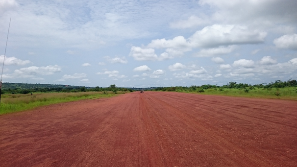
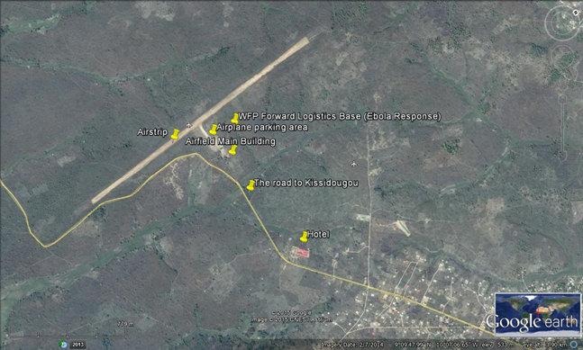
2.2.6 Guinea Kissidougou National Airfield
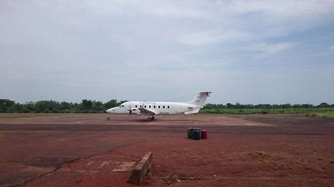
Kissidougou airfield is 8 km away from Kissidougou town. There are no significant plane movement except for the humanitarian flights. The mining company Rio Tinto has started some flights to Kissidougou. Passengers travelling on private planes must pay 20,000 GNF before boarding the plane. There is no Guinean CAA activity but the airfield remains useful for helicopter landing. In the airfield, there is a private fire-fighting society contracted by WFP Common Services due to the presence of the fuel tank requested by WFP. WFP also pays a per diem to the representatives of National Navigation Office in charge of the tower control and his assistant.
|
Airfield Details |
|||
|---|---|---|---|
|
Country |
Guinea |
Latitude |
9.16 |
|
Province / District |
Nzérékoré / Kissidougou |
Longitude |
-10.1225 |
|
Airfield Name |
Kissidougou |
Elevation (ft & m) |
1,808 ft / 551.08 m |
|
IATA & ICAO codes |
GUKU |
Surface |
Compact |
|
Town or City (closest) |
Kissidougou |
Runway Condition |
Good |
|
NGO / UN (on ground) |
WFP |
Passenger / Cargo Security Screening (Yes / No) |
No |
|
Runway Dimension (m) |
1800 m x 40 m |
Ground Handling (Yes / No) |
No |
|
Refueling Capacity |
Yes |
Runway Lighting (Yes / No) |
No |
|
Runway Heading |
01/19 |
Fire Fighting Equipment (Yes / No) |
Yes contracted by WFP |
|
Air Traffic Control (AFIS) (Yes / No) |
Yes |
Windsock (Yes / No) |
Yes |
|
Weather Information (Yes / No) |
Yes |
Aircraft Parking space (Yes / No) |
Yes |
|
Navigation Aids (Yes / No) |
No |
Perimeter fencing (Yes / No) |
No |
Fuel Services Charges
During the Ebola Response, WFP Common Service, with special agreement with TOTAL, positioned a 34,000 liter tank at the airfield to store JET A-1 fuel to enable the deployment of helicopters in the east of the country. This tank is managed by TOTAL which charges UNHAS/WFP according to fuel consumption.
Royalties / Non Objection Fees (NOFs)
No royalties or fees applicable at the airfield.
For information on Guinea
Conakry Airport contacts, please see the following
link: 4.5 Guinea
Airport Company Contact List
2.2.7 Guinea Labé Tata National Airfield
Labé Tata airfield is around 4 km distance from Labé city and is considered as one of the three regional airports in the country. Since the national carrier ceased its activities the airfield is no longer used. There is no Guinean CAA activity but it remains useful for helicopter landing.
|
Airfield Details |
|||
|---|---|---|---|
|
Country |
Guinea |
Latitude |
11.33056 |
|
Province / District |
Labe / Labe |
Longitude |
-12.29639 |
|
Airfield Name |
Labe |
Elevation (ft) |
3,396 ft / 1,035.1 m |
|
IATA & ICAO codes |
GULB |
Surface |
Compact |
|
Town or City (closest) |
Labe |
Runway Condition |
Good |
|
NGO / UN (on ground) |
WFP |
Passenger / Cargo Security Screening (Yes / No) |
No |
|
Runway Dimension (m) |
3,000 m x 45 m |
Ground Handling (Yes / No) |
No |
|
Refueling Capacity |
N/A |
Runway Lighting (Yes / No) |
No |
|
Runway Heading |
06/24 |
Fire Fighting Equipment (Yes / No) |
No |
|
Air Traffic Control (Yes / No) |
Yes( AFIS) |
Windsock (Yes / No) |
No |
|
Weather Information (Yes / No) |
No |
Aircraft Parking space (Yes / No) |
Yes |
|
Navigation Aids (Yes / No) |
Yes |
Perimeter fencing (Yes / No) |
No |
Fuel Services Charges
There are no Fuel services available at Labé airfield.
Royalties / Non Objection Fees (NOFs)
There are no royalties or fees applicable at the airfield.
For information on Guinea Conakry Airport contacts, please see the following link: 4.5 Guinea Airport Company Contact List
2.2.8 Guinea Macenta National Airfield
The airfield is 8 km away from the town of Macenta. There are no activities in Macenta airport besides the humanitarian flights. This airfield is considered closed by the National Navigation Authority. There is no Guinea CAA activity but it is useful for helicopter landing.
|
Airfield Details |
|||
|---|---|---|---|
|
Country |
Guinea |
Latitude |
8.484444 |
|
Province / District |
Nzérékoré / Macenta |
Longitude |
-9.525278 |
|
Airfield Name |
Macenta |
Elevation (ft & m) |
3,396 ft / 1,035.1 m |
|
IATA & ICAO codes |
GUMA |
Surface |
Compact |
|
Town or City (closest) |
Macenta |
Runway Condition |
Bad |
|
NGO / UN (on ground) |
French Red Cross |
Passenger / Cargo Security Screening (Yes / No) |
No |
|
Runway Dimension |
1,400 m x 40 m |
Ground Handling (Yes / No) |
No |
|
Refueling Capacity |
N/A |
Runway Lighting (Yes / No) |
No |
|
Runway Heading |
07/25 |
Fire Fighting Equipment (Yes / No) |
No |
|
Air Traffic Control (Yes / No) |
No |
Windsock (Yes / No) |
No |
|
Weather Information (Yes / No) |
No |
Aircraft Parking space (Yes / No) |
No |
|
Navigation Aids (Yes / No) |
No |
Perimeter fencing (Yes / No) |
No |
Fuel Services Charges
There are no fuel services available at the airfield.
Royalties / Non Objection Fees (NOFs)
There are no royalties or fees applicable at the airfield.
For information on Guinea Conakry Airport contacts, please see the following link: 4.5 Guinea Airport Company Contact List
2.2.9 Guinea Nzérékoré National Airport
Nzérékoré airport is 22 km away from the city of Nzérékoré. The national police and the Guinean military ensure the security of the airport. WFP Common Services pays a per diem to the Air controller of the National Navigation Authority. There is basically no other activity besides humanitarian flights.
|
Airfield Details |
|||
|---|---|---|---|
|
Country |
Guinea |
Latitude |
7.815 |
|
Province / District |
Nzérékoré / Nzérékoré |
Longitude |
-8.704167 |
|
Airfield Name |
Nzérékoré |
Elevation (ft & m) |
1,657 ft / 505.05 m |
|
IATA & ICAO codes |
GUNZ |
Surface |
Compact |
|
Town or City (closest) |
Nzérékoré |
Runway Condition |
Good |
|
NGO / UN (on ground) |
WFP |
Passenger / Cargo Security Screening (Yes / No) |
No |
|
Runway Dimension (M) |
1,500 m x 40 m |
Ground Handling (Yes / No) |
No |
|
Refueling Capacity |
N/A |
Runway Lighting (Yes / No) |
No |
|
Runway Heading |
18/36 |
Fire Fighting Equipment (Yes / No) |
No |
|
Air Traffic Control (AFIS) (Yes / No) |
Yes |
Windsock (Yes / No) |
Yes |
|
Weather Information (Yes / No) |
No |
Aircraft Parking space (Yes / No) |
Yes |
|
Navigation Aids (Yes / No) |
No |
Perimeter fencing (Yes / No) |
No |
Fuel Services Charges
There is no fuel service at the airfield.
Royalties / Non Objection Fees (NOFs)
There are no royalties or fees applicable at the airfield.
For information on Guinea Conakry Airport contacts, please see the following link: 4.5 Guinea Airport Company Contact List