2 Central African Republic Logistics Infrastructure
The following sections contain information on the Logistics Infrastructure of Central African Republic:
2.1 Central African Republic Port Assessment
For information on Central African Republic port contact details, please see the following link:
4.2.8 Central African Republic Port and Waterways Company Contact List
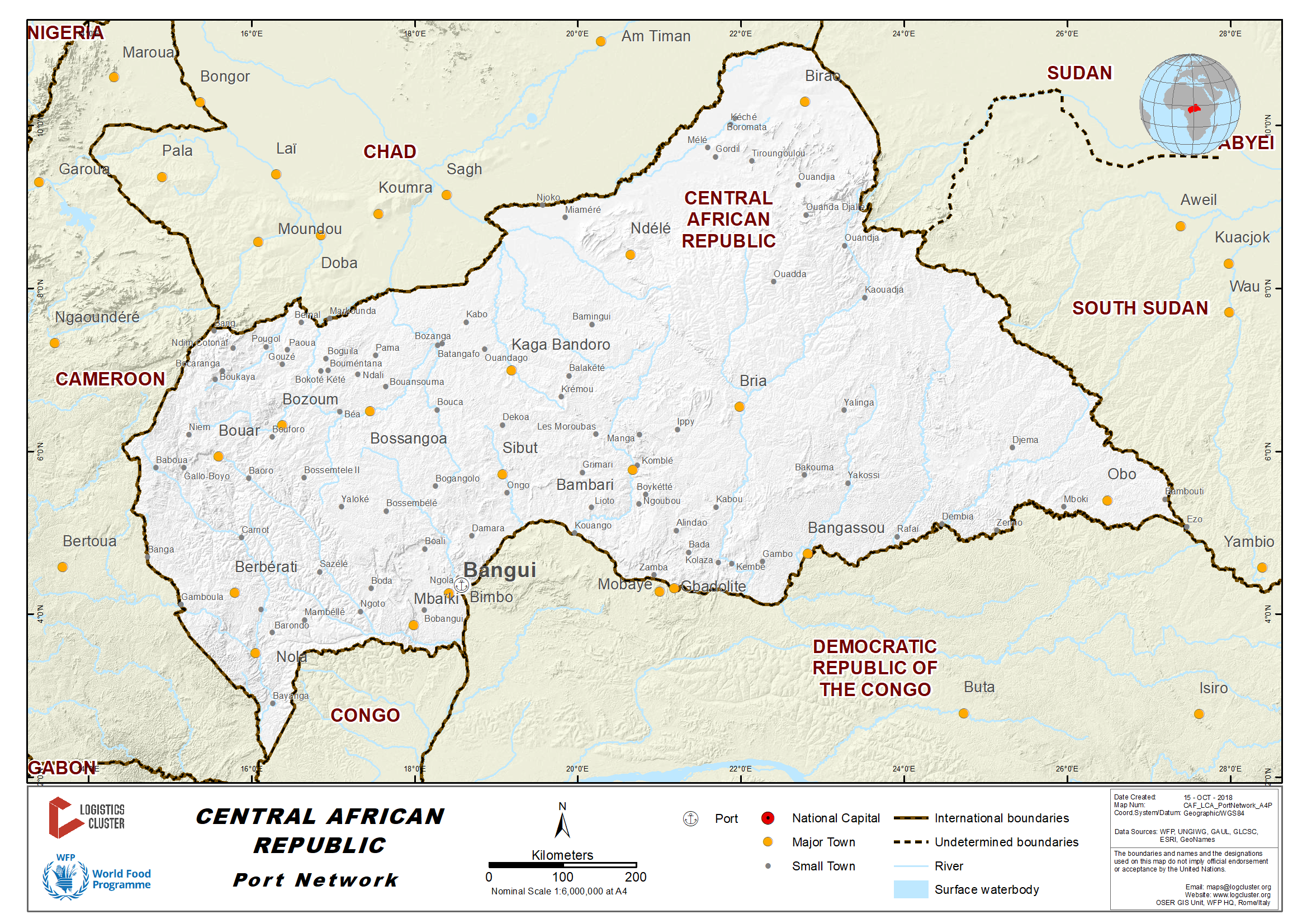
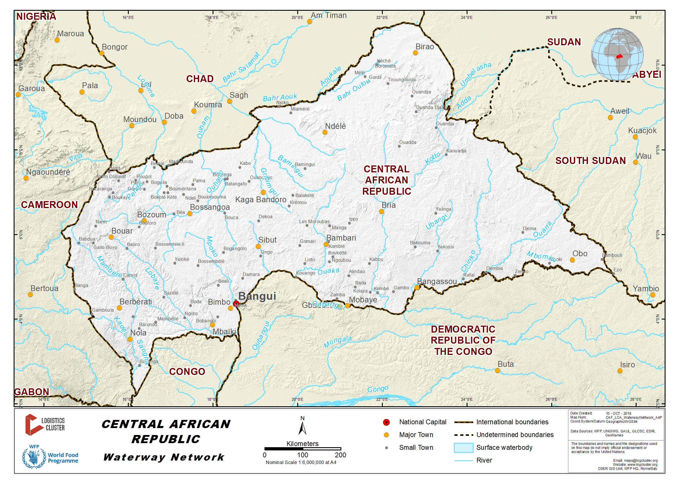
The Central African Republic is a landlocked country. Therefore, the government has to identify the most suitable corridor to access the sea. To this effect, the country has four possibilities, with Sudan, the two Congo and Cameroon.
The Central African Republic can access the sea through the territory of Sudan, at Port-Sudan on the Indian Ocean. The main difficulty in using Port-Sudan as an entry point for goods destined to the Central African Republic is the state of the road in the Vakaga préfecture. Actually, road infrastructure in this region is in a poor state and almost impassable during the rainy season. Therefore, the traffic could be possible only for six months during the dry season. Another difficulty could be the fact that the two countries belong to two different economic area and the insecurity in the northern country due to the presence of rebels and the unrest in the Darfur (Sudan).
Possible access to the sea
via the two Congo Pointe-Noire in the Republic of the Congo and
Matadi in the Democratic Republic of the Congo are two other
possibilities for the Central African Republic to access the sea.
This corridor could be cheaper and faster. But, the main weak
points of this corridor are the use of combined transport
(rail/river from Pointe-Noire and road/river from Matadi), which
increases the risk of (food commodity) loss. Also, the road and
rail links have proved to be unreliable for non-oil traffic. The
seasonal navigability on the Ubangui River, which is limited to the
wet season (From June to January), is another constraint. The
continual silting of the Ubangui river-bed, which necessitate a
constant and costly dredging of the waterway.
Douala in Cameroon as the most suitable access point to the sea for
the Central African Republic. The estuary port of Douala is
situated at over 1,450 kms from Bangui. This is actually the main
port for the Central African Republic, handling about 80% of the
international trade of this country. The main advantage of the port
Douala is the fact that Cameroon and the Central African Republic
belong to the same economic zone (CEMAC ). However, the transit
time at the port of Douala remains high (over two weeks) and it
could take more than 20 days for a truck to cover the distance of
1,450 km which separates Douala from Bangui. It
should be mentioned that many stretches of this roads are still
unpaved.
2.1 Democratic Republic of Congo Port Assessment
2.1.1 Republic of the Congo Port of Pointe Noire
4.4 Republic of the Congo Port and Waterways Companies Contact List
2.1.1 Central African Republic Port of Bangui
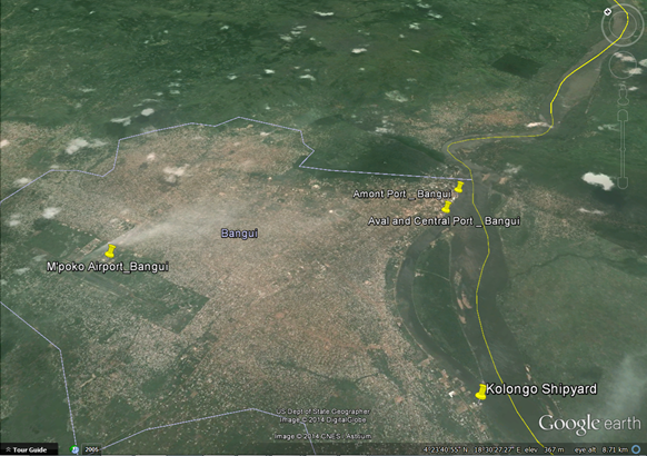
Above: Port localisation in Bangui district/town
Port Overview
In 1996 Bolloré Africa Logistics (SOCATRAF affiliated) was
awarded the concession for the container terminal at the port of
Bangui. SOCATRAF is a mixed company (60% for the Bolloré Group and
40% for the government of the Central African Republic) which
manages the river port and barge transport along the Ubangui River
up to Brazzaville or Kinshasa. However, the container section is
managed by SCAC DELMAS VIELJEUX (SDV), another company of the
Bolloré Group.
The corridor starts at the ports of Pointe Noire (RoC) or Matadi
(DRC) to reach Brazzaville or Kinshasa by railway or road. From
these two towns, cargo is loaded on barges and transported through
the rivers Congo and Ubangui up to the port of Bangui.
On February 26-27, 2018, in Bangui, transporters in Cameroon and Central African port and customs authorities met to discuss the problems encountered by Central African operators in Douala port and on the Douala-Bangui corridor. On this corridor, about 90% of the freight is transported by Cameroonians. According to Central Africa, this represents a violation of the law which stipulates that 65% of the goods should be transported by Central African transporters. “Normally, from Douala Port to Bangui, only two checkpoints should be installed. However, there is more than fifty. So, these additional checkpoints generate costs that affect the selling price in Central Africa”, Bertrand Ngougnon, chairman of central African transporters’ council, lamented. Indeed, earlier in February, Cameroon’s syndicates complained about the multiple customs, police and road safety agents’ checkpoints along this corridor and Douala-Ndjamena. They also revealed that transporters had to pay between CFA1000 and CFA5000 at each checkpoint during every trip. Based on the figures provided by the syndicalist, for a trip monthly, all the transporters pay about CFA175 billion at the checkpoints along Douala-Ndjamena corridor, every year.
In March 2018, the Autonomous Port of Douala (PAD) has opened an office in Bangui, the capital of the landlocked Central African Republic (CAR) which uses the facility for the bulk of its exports and imports. After Ndjamena in Chad in December 2017, the CAR now hosts the latest PAD office. The Cameroonian port authorities say this move explains their determination to reclaim and retain such landlocked neighbours at the heart of its business expansion strategy. According to statistics from the General Directorate of Customs (DGD), some CFA 55 billions of CAR goods pass through the port of Douala each year. Against this backdrop, “the opening of the PAD offices in Ndjamena and Bangui is indeed a new offensive to regain the threatened market share and retain customers,” the authorities of the port said. The meeting between carriers, port authorities and Cameroonian and CAR customs officials held on the heels of the initiative of the Central African Council of Carriers (CCT) provided an opportunity to examine the problems encountered by Central African economic operators in the port of Douala. According to customs director, more than 80 percent of Central African imports and exports pass through the port of Douala, which are transported by road for nearly 1,500 km.
|
Port Location and Contacts |
|
|---|---|
|
Country |
CENTRAL AFRICAN REPUBLIC |
|
Province or District |
Lobaye |
|
Town or City (Closest location) with Distance (km) |
Name : BANGUI km: 0.5 KM FROM CITY CENTER |
|
Port's Complete Name |
Port fluvial de Bangui |
|
Latitude |
4.357486 |
|
Longitude |
18.57779 |
|
Managing Company or Port Authority (If more than one operator, break down by area of operation) |
SOCATRAF (Bollore Africa Logistics group) |
|
Management Contact Person |
SOCATRAF Bruno PERIER - Directeur Général +236 21 61 43 15 / +236 75 50 24 64 |
|
Closest Airport and Frequent Airlines to / from International Destinations |
Airport Name: Bangui M’poko |
For information on Central African Republic Port of Bangui, please
see the following link:
4.8 Central African Republic Port and Waterways Company Contact List
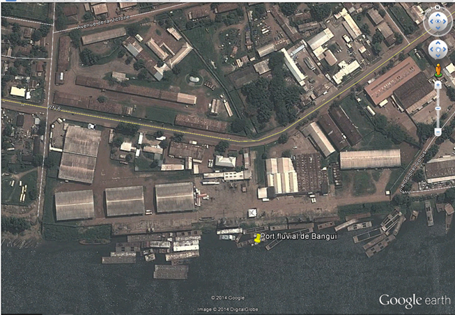
Above: Aval and Central Port areas including:
- Warehouses: 10,000 m2
- Berth
- Mobile Crane
- Fixed Crane
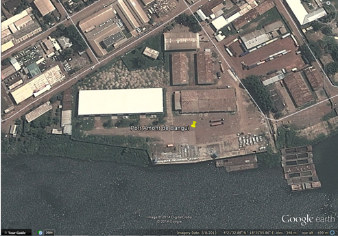
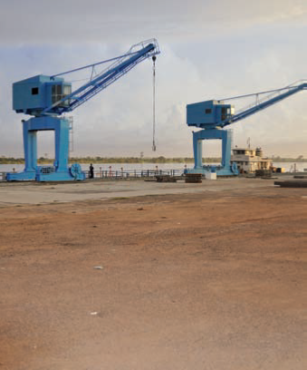
Above: Amont Port Areas including:
- Container Berth: 5000 m 2
- Fixed Crane
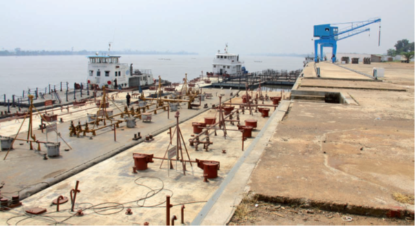
Above: Main Port Berth
Above: Port Hoists
Port Performance
| Seasonal Constraints | Yes/No |
From <month> to <month> |
|
|---|---|---|---|
|
Rainy Season |
Yes |
June-July>>December |
|
|
Major Import Campaigns |
Yes |
June-July>>December |
|
|
Handling Figures |
Year 2016 figures N/A |
||
|
Handling Figures |
Year 2012 |
|---|---|
|
Vessel Calls |
|
|
Container Traffic (TEUs) |
5000 |
|
Handling Figures Bulk and Break Bulk |
2012 |
|---|---|
|
Bulk (MT) |
n/a |
|
Break bulk (MT) |
n/a |
Discharge Rates and Terminal Handling Charges
Fee for loading or unloading of a container is 166 600 XAF /TTC.
Cost of berthing fee for a boat: 50 000 to 500 000 XAF, depending on capacity.
The stay in quay is 50 XAF per day per 1 ton
Berthing Specifications
The maintenance of the entire network of navigable waterways of
the Congo-Ubangui-Sangha Rivers, representing some 2,000 km, is the
responsibility of SCEVN[1], a company jointly owned by the Central
African Republic and the Republic of the Congo.
In order to facilitate the access to the port of Bangui, constant
dredging of the Ubangui and Congo should be done, which is
unfortunately not the case. As a result, the beds of the two rivers
are subject to silting as demonstrated by the low draught level.
Consequently, only barges could navigate on these rivers.
The quay at the port of Bangui measures about 330m, divided into
the upstream port (Port amont) for the cement and petroleum
products and the downstream port (Port aval) for general cargo such
as cereals and cotton.
It should be mentioned that only two barges can berthed at the same
time.
[1] Service Commun d’Entretien des Voies Navigables du bassin
Congo-Oubangui-Sangha.
| Type of Berth | Quantity |
Length (m) |
Maximum Draft (m) |
|---|---|---|---|
|
Conventional Berth |
3 |
545m |
n/a |
|
Container Berth |
n/a |
n/a |
n/a |
|
Silo Berth |
n/a |
n/a |
n/a |
|
Berthing Tugs |
n/a |
||
|
Water Barges |
3 |
Port Handling Equipment
The port is under the management of SOCATRAF, which has been awarded in 1996 to manage the concession of the container port terminal (Port Amont).All port handling equipment belong to SOCATRAF, which also supports manual handling with workforce.
|
Equipment |
Available (Yes / No) |
Total Quantity and Capacity Available |
Comments on Current Condition and Actual Usage |
|---|---|---|---|
|
Dockside Crane |
Yes |
1 (30mt) 1 (110 mt) |
Operational |
|
Container Gantries |
No |
||
|
Mobile Cranes |
Yes |
4 (3 mt each) |
Operational |
|
Reachstacker |
Yes |
1 Svetruck (40mt) |
Operational |
|
RoRo Tugmaster (w/ Trailer) |
No |
||
|
Grain Elevator w/ Bagging Machines |
No |
||
|
Transtrainer |
Yes |
3 ADF 185m3/hr berth |
Operational |
|
Forklifts |
Yes |
5 (2*30mt, 2*5mt and 1*2.5mt) |
Operational |
Container Facilities
|
Facilities |
20 ft |
40 ft |
|---|---|---|
|
Container Facilities Available |
Yes |
Yes |
|
Container Freight Station (CFS) |
Yes |
Yes |
|
Refrigerated Container Stations |
No |
No |
Customs Guidance
For information on Central African Republic Customs Guidance, please see the following links:
1.2 Central African Republic Customs Information
Terminal Information
Main Storage Terminal
|
Storage Type |
Number of Storage Facilities |
Area (square meters) |
|---|---|---|
|
General Cargo |
5 |
2000m2 |
Stevedoring
All activities are handled by SOCATRAF at port.
Hiterland Information
Road - transport Company available.
Waterway – river barge available at Port Amont.
Port Security
Private security on site is available for global compound security. Customer is required to contract an extra private security company.
|
Security |
|
|---|---|
|
ISPS Compliant (Yes / No) |
No |
|
Current ISPS Level |
n/a |
|
Police Boats |
No |
|
Fire Engines |
Yes |
The port is under the management of SOCATRAF, which has been awarded in 1996 to manage the concession of the container port terminal (Port Amont).All port handling equipment belong to SOCATRAF, which also supports manual handling with workforce.
2.2 Central African Republic Aviation
Key airport information may also be found at: World Aero Data information on Central African Republic
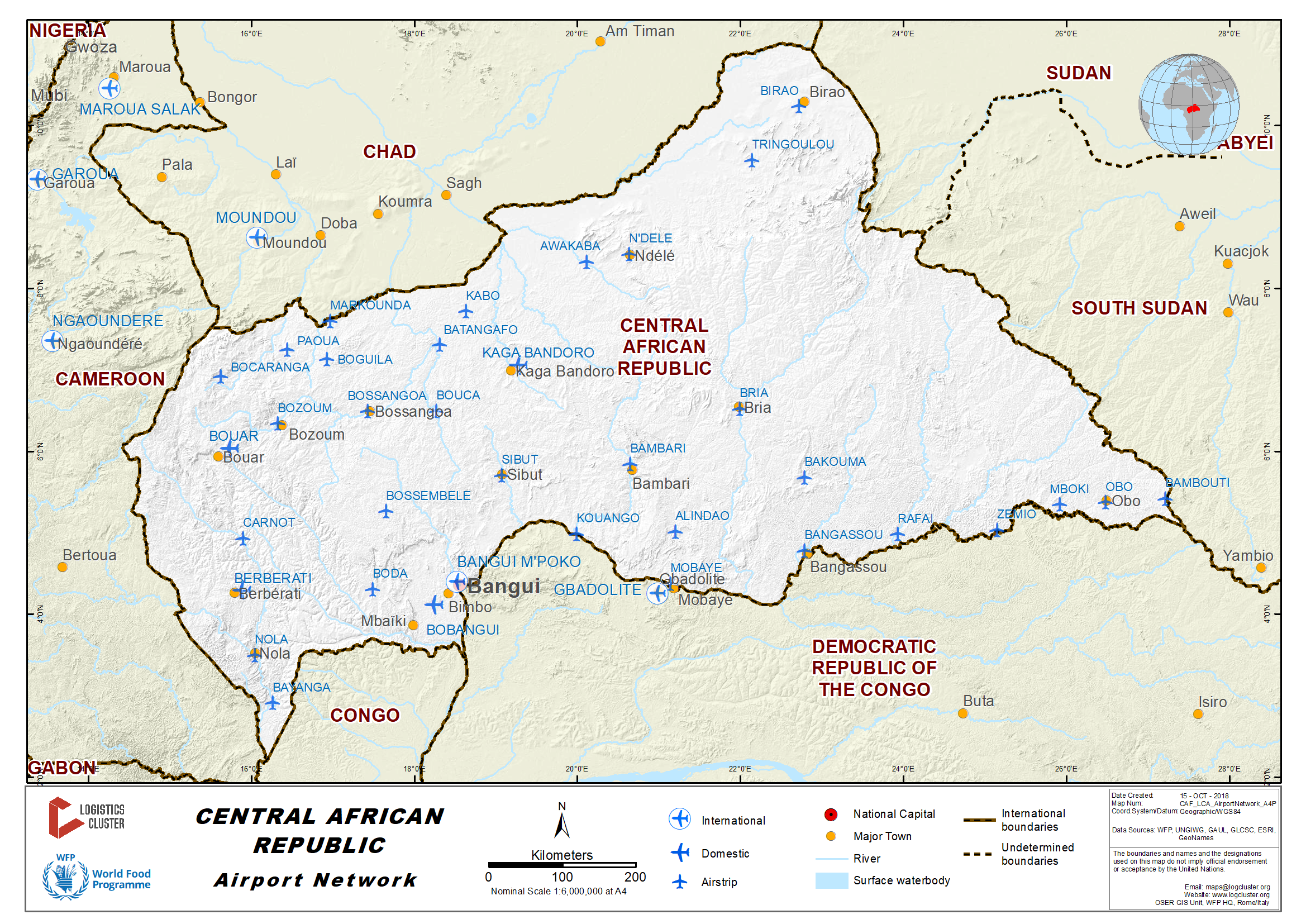
Bangui is the main airport in the country with international standards. The country's airfield environment is composed of about 41 secondary inland airports but only a limited number of them are practicable for the aircrafts commonly used for humanitarian transportation.
For information on Central African Republic Secondary Airports, please see the following document:
Secondary airports in Central African Republic
Management of air transport
Placed under the Ministry of
Transport, the General Directorate for Civil Aviation actually
defines the country’s air transport policy, including security and
safety matters. But the granting of overflight and landing permits
is the responsibility of the Ministry of Defence upon advice from
the Ministry of Transport.
All the activities of the Bangui International Airport are managed
by ASECNA; except for the security on the tarmac, which is under
the responsibility of the gendarmeries and the customs and
immigration. ASECNA provides the usual services of control tower,
air space travel, weather forecast as well as security in the
terminal. AHS-Menzies, a private international company is
responsible for the handling and ground services to aircrafts:
checking, cargo/luggage handling and storage. Air traffic in the
Central African Republic is extremely limited. Bangui is the only
airport of the country with a significant traffic, mainly
international connections with some African cities (Douala,
Brazzaville, etc.) and Paris in France.
With the exception of the United Nations Humanitarian Air Service
(UNHAS), domestic traffic from Bangui to secondary airfields inside
the country are rather inexistent.
Air traffic
Air traffic in the Central African
Republic is extremely limited. Bangui is the only airport of the
country with a significant traffic, mainly international
connections with some African cities (Douala, Brazzaville, etc.)
and Paris in France.
Except for the United Nations Humanitarian Air Service (UNHAS),
domestic traffic from Bangui to secondary airfields inside the
country is rather inexistent.
For information on Central African Republic Airport contacts, please see the following links:
2.2.1 Central African Republic Bangui-M’Poko International Airport
Overview
| Location Details | |||
|---|---|---|---|
| Country | Central African Republic | Latitude | 4.398475 |
| Province / District | Ombelle M’poko | Longitude | 18.51879 |
| Town or City (Closest) | Bangui | Elevation (ft and m) | 1,208 ft / 368.2 m |
| Airfield Name | Bangui-M’Poko International Airport | IATA and ICAO Codes | BGF /FEFF |
| Open From (hours) | 07:30 | Open To (hours) | 15:00 |
Bangui-M’poko is the only airport in the Central African
Republic with international standards. It is situated at about 5 km
northwest of Bangui downtown. The airport was open to traffic in
1967 and the last time its runway was resurfaced dates back to
1987. According to last available statistics, 66,854
passengers transited through Bangui International Airport.
The main international companies serving Bangui International
Airport are TAAG Angola Airlines (Brazzaville, Douala, Pointe-Noire
and Luanda), Afriqiyah Airways (Tripoli), Toumaï Air Tchad
(Brazzaville, Cotonou, Douala, Libreville, Lomé and N’djamena) Air
France (Paris-Charles de Gaulle), ASKY (Douala, Lome, Cotonou,
Abidjan, Dakar, Niamey, Nouakchott, Conakry, Abuja etc.) and Kenya
Airways (Nairobi, Bujumbura, Dar Es Salam, Kampala, Entebbe +
multiples connections) VIA AIR: for domestic cargo.
The regular domestic traffic in the Central African
Republic is provided by the United Nations Humanitarian Air
Services (UNHAS), with about 13/14 locations served in the
country. The fleet of UNHAS to date (Nov 2016) include two LET
410, offering 19 seats or 1.5 MT capacity x 2, 1 DASH 8 = 35 seats
and 1 CESNA 208 = 9 seats. MINUSCA: helicopters = 11, planes = 14,
ICRC = 2 planes, MSF = 1 plane.
Considering the insecurity prevailing within the Central African Republic, UNHAS flights are absolutely necessary for the security of UN and other NGOs activities in the country.
For information on Central African Republic Aiport contact details, please see the following links:
4.3 Central African Republic Airport Company Contact List
Runways
It should be recalled Bangui-M’poko International Airport is authorized only for aircraft equipped with bilateral radio communications. U-turn on the runway is prohibited for aircraft above 40 metric tons weight.
|
Runway #1 - 17 |
|
|---|---|
|
Runway Dimensions |
2640 (Usable length - 2600m) x 45 m (Standard ICAO) |
|
Orientation |
17 / 35 |
|
Surface |
Concrete / asphalted |
Helicopter Pad(s)
A helicopter pad is located in the military base, with restricted access to civilians.
|
Helipad #1 |
|
|---|---|
|
Present (Yes / No) |
Yes |
|
Largest helicopter that can land |
MI 8 |
|
Width and Length (metres) |
50 / 100 |
|
Surface |
Asphalted |
Airport Infrastructure Details
|
Customs |
Yes |
JET A-1 fuel |
Yes |
|---|---|---|---|
|
Immigration |
Yes |
AVGAS 100 |
Yes |
|
Terminal Building |
Yes |
Single Point Refueling |
Yes |
|
Passenger Terminal |
Yes |
Air Starter Units |
Yes |
|
Cargo terminal |
Yes |
Ground Power (mobile) |
Yes |
|
Pax transport to airfield |
Yes |
Ground Handling Services |
Yes |
|
Control Tower |
Yes |
Latrine Servicing |
Yes |
|
Weather Facilities |
Yes |
Fire Fighting Category (ICAO) |
Yes |
|
Catering Services |
Yes |
De-icing Equipment |
- |
|
Base Operating Room |
- |
Parking Ramp Lighting |
Yes |
|
Airport Radar |
- |
Approach & Runway Lights |
Yes |
|
NDB |
Yes |
VOR |
Yes |
|
ILS |
Yes |
|
Passenger and Cargo Performance Indicator
Further statistics on UNHAS flight are as follows.
Monthly passengers transported: about 500 persons
Total flight hours monthly: about 83 hours
|
Performance for 2005 |
Annual Figures |
|---|---|
|
Total aircraft movements |
n/a |
|
Total passengers |
66.854 (2005) |
|
Total capacity of the airport (metric tonnes) |
3000 MVT |
|
Current activity of the airport (metric tonnes) |
1200 MVT |
|
Current use by Humanitarian flights (UNHAS) |
n/a |
Airport Operating Details
| Operating Details | |||
|---|---|---|---|
| Maximum sized aircraft which can be offloaded on bulk cargo: | B 747 / Antonov 124 | ||
| Maximum sized aircraft that can be offloaded on pallet | B 747 | ||
| Total aircraft parking area (m²) | 31,500 | ||
| Storage Area (mt) | 350 ( 250 mt ) | Cubic Meters (m³) | n/a |
| Cargo Handling Equipment Available (Yes / No) | yes | If "Yes" specify below | |
| Elevators / Hi Loaders (Yes / No) | yes | Max Capacity (mt) | 14 |
| Can elevators / hi loaders reach the upper level of a B747 (Yes / No) | yes, The infrastructure and equipment allows offloading of 4 aircraft B 747 per day. The offloading time is estimated at two hours per B 747 aircraft. | ||
| Loading Ramps (Yes / No) | Unit for Cargo & luggage | ||
Airfield Cost
For information on Central African Republic Airport costs, please see the following link:
The overflight and landing authorizations for civil foreign aircrafts are delivered by the Ministry of Defense following advices of the Ministry of Transport and Civil Aviation, Ministry of Public Security and Territorial Administration (Homeland Affairs). The request for authorization should be submitted in written form (telex, radio message or any other means) to the Ministry of Defense, at least 72 hours before the expected date for the flight. But a special derogation can be granted by the Minister of Defense. The following documents should be attached to the request for overflight and landing permit: a. Type of aircraft. b. Registration of aircraft. c. Name of pilot. d. Number of crew. e. Number of passengers. f. Origin of aircraft. g. Destination of aircraft. h. Airport of stopover. i. Airport of exit. j. Nature of cargo. k. Date of entry and departure. l. Purpose of visit. m. Services required. The answer of the Ministry of Defense should be given 72 hours following the request. In case of no response within this timeframe, the request should be considered as rejected.
Security
Level: Good
Companies Available
Air Operators - Air transport companies:
TAAG Angola Airlines (Brazzaville, Douala, Pointe-Noire and Luanda)
Afriqiyah Airways (Tripoli)
Toumaï Air Tchad (Brazzaville, Cotonou, Douala, Libreville, Lomé and N’djamena)
Air France (Paris-Charles de Gaulle)
ASKY (Douala, Lomé, Cotonou, Nouakchott, Conakry, Dakar, Niamey, Abuja, etc.)
Kenya Airways (Nairobi, Bujumbura, Kampala, Kigali, Dar Es Salam, etc.)
VIA AIR: domestic cargo
UNHAS (domestics flights)
Air Navigation Security and safety: ASECNA
Handling and ground service: AHS MENZIES
Information on some aviation service providers can be found at: AZ Freight information on Central African Republic
2.2.2 Central African Republic Berbérati Airport
Overview
Berbérati is the second town of the Central African Republic. It is the capital of the Mambéré-Kadeï Prefecture. Berbérati is a secondary airport to be used for domestic traffic only.
|
Airport Details |
|||
|---|---|---|---|
|
Country |
Central African Republic |
Latitude |
4.221583 |
|
Province / District |
Mambéré-Kadeï |
Longitude |
15.78637 |
|
Airport Name |
Berbérati Airport |
Elevation (ft) |
1,929 ft / 587.96 m |
|
IATA & ICAO codes |
BBT /FEFT |
Surface |
ASPHALT |
|
Town or City (closest) |
Berbérati |
Runway Condition |
n/a |
|
NGO / UN (on ground) |
n/a |
Passenger / Cargo Security Screening (Yes / No) |
n/a |
|
Runway Dimension |
1,660 m x 30 m |
Ground Handling (Yes / No) |
n/a |
|
Refueling Capacity |
n/a |
Runway Lighting (Yes / No) |
no |
|
Runway Heading |
n/a |
Fire Fighting Equipment (Yes / No) |
n/a |
|
Air Traffic Control (Yes / No) |
n/a |
Windsock (Yes / No) |
n/a |
|
Weather Information (Yes / No) |
n/a |
Aircraft Parking space (Yes / No) |
n/a |
|
Navigation Aids (Yes / No) |
n/a |
Perimeter fencing (Yes / No) |
n/a |
For information on Central African Republic Airport contact details, please see the following link:
4.3 Central African Republic Airport Company Contact List
2.3 Central African Republic Road Network
Overview
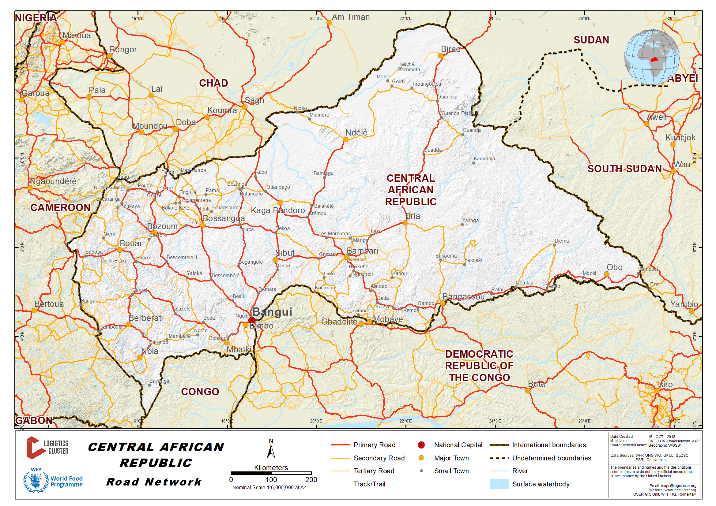
The roads network in the
Central African Republic covers a total distance of about 24,000 km
with only 700 km asphalted. The national roads are about 4,500 km
road while the regional roads cover about 3,900 km. The remaining
15,268 km (more than 60%) represents tracks or rural roads across
villages.
The whole network is rather in a bad shape since no proper
rehabilitation or maintenance programme is in place. Throughout the
country many villages are not reachable and almost cut off year
round (such as the Vakaga region in the north-eastern part of the
country). This constitutes a major constraint to the development of
these areas.
MINUSCA is rehabilitating roads and bridges for the movement of their troops, however,this is a temporary programme.
During the second part of 2018, ACTED, through the Logistics Cluster, started rehabilitating bridges based on the humanitarian community needs. This is executed through a “Brigade d’Intervention Mobile”.
During years 2014, 2015, 2016, WFP together with ACTED has rehabilitated several bridges and ferries but the Ministry of Transport and the Ministry of Infrastructures didn’t approach the local communities to sensitize them on the importance of this activity and most of the wood and iron used to rehabilitate the works were looted. Up to 30 bridges were rehabilitated between: Bozoum and Bocaranga, Bozoum and Paoua, Bozoum and Bossangoa,Bozoum and Bossemptele, as well as Dam of Bozoum. One ferry and 13 bridges were rehabilitated between Grimari and Kouango.
The private company SOGEA/ SATOM with a two-year contract is working on the tar road from Bouar to Baoro (east of Bouar). End of the rehabilitation is expected in 2020. From 2010 to 2013, the road between Garoua Boulai and Bouar was rehabilitated (tar) by a Chinese company and SATOM.
UNOPS with a support of the World Bank started rehabilitating the road between Kaga-Bandoro and Ndele as well as the 43-meter bridge of Bamingi. This should be finalized by the end of 2018. The second part between Ndele and Birao rehabilitation should start soon (July 2019). The second project funded by World Bank should be completed by 2021. At the same time, UNOPS is purchasing heavy duty equipment and will train staff from the Ministry of Infrastructure to maintain the road between Kaga and Ndele and between Ndele and Birao.
Rain
barriers
There is no specific restriction on road traffic during the rainy
season as it is the case in some neighboring countries, where
several unpaved roads are close. However, rain barriers are
established across the country in order to avoid further
deterioration of the dirt roads. Heavy trucks should therefore wait
until the end of rains (about six hours) before trip can continue.
This restriction applies particularly/strictly on newly
rehabilitated roads. In 2018 and 2019, UNOPS will train staff
from the Ministry of Transport and Ministry of Infrastructure on
management of rain barriers.
For information on Central African Republic Road Network Contact details, please see the following link:
4.2.1 Central African Republic Government Contact List
Distance Matrix
Ministry of Transport RCA_Road_distance_matrix_2018.05.25
Travel Time Matrix
Not available - it depends on the dry and wet season; rainy season is from May to November. Travel time depends also on the availability of MINUSCA escorts.
Road Class and Surface Conditions
2.4 Central African Republic Waterways Assessment
Overview
For information on Port contact details, please see the following link:
4.8 Central African Republic Port and Waterways Company Contact List
A landlocked country, the CAR is served by Ubangui, which is a major river transport route. However, traffic on this maritime route is confronted by low water (not allowing navigation of barges during dry season) and silting which slows down the navigability. For good management and maintenance of Ubangui and Congo rivers, the Republic of Congo, the Central African Republic and RD.Congo and the other riparian states adopted in 2008 "the tripartite memorandum of understanding concerning the modalities of maintenance of the tracks waterways of common interest and the Cémac / DRC Code of Inland Navigation of December 1999". Desalination of the watercourse by dredging and marking is one of the proposed solutions. State charges are allocated by portion of watercourses, in accordance with the tripartite Memorandum of Understanding concerning the maintenance of waterways of common interest. This agreement provides the maintenance and marking of the Pool Malebo road (PK 10 to PK 50 in Maloukou) and the section between PK 50 on the Congo River and Mobenzele (PK 173 on Ubangui). From PK 339 of the Congo River, 10 km upstream from Bolobo to Liranga, maintenance and marking on the right bank are the responsibility of Congo and CAR. Oubangui's dredging and redevelopment operations since its confluence with the river to Bangui are also carried out by these two countries. The purpose of this work is to provide a maximum draft of 0.9 m in low water at the 1.2m scale at the threshold of Zinga. The tripartite agreement also provides for a permanent inspection mechanism on inland waterways, which is monitored by the State services. Captains and other crew members are required to cooperate with the inspection service (June 2018).
Company Information
In 1996 Bolloré Africa Logistics was awarded the concession for the container terminal at the port of Bangui. Bolloré Africa Logistics, which has a workforce of 200, carries merchandise up and down the Ubangui river and between the cities of Brazzaville/ Kinshasa and Bangui. All the companies present to support operations at the port are Bollore Africa Logistics affiliated.
|
BOLLORE LOGISTICS AFRICA |
|
|---|---|
|
Number of Boats |
n/a |
|
Tonnage / Volume Carrying Capacity |
n/a |
|
Number of Barges |
47 (bulk) + 27 (fuel) + 14 (flat) |
|
Tonnage / Volume Carrying Capacity |
From 150 MT to 600 MT |
|
Number of Tugs |
10 |
|
Tonnage / Volume Carrying Capacity |
Max power 1,200 HP |
|
Other (specify) |
1 naval repair shop |
Key Routes
|
Ubangui River |
From: Brazzaville/Kinshasa To: Bangui |
From: Bangui To: Mobaye |
|---|---|---|
|
Total Distance (km) |
1,180 km |
380 km |
|
Width (m): Broadest Narrowest |
Information available with “voies navigables” |
Information available with “voies navigables” |
|
River Flow (m³ / second) |
4 092 m3/s |
4 092 m3/s |
|
Seasonal Affects |
This corridor is operational during the rainy season (June-July through December) only |
This corridor is operational during the rainy season (June-July through December) only |
|
Maximum Weight and Size of Vessels |
2,000 mt |
38 Baleinieres from 18 meters to 32 meters or from 25 Mt to 85 Mt capacity |
|
Regular Traffic Passenger / Cargo |
60,000 MT of different cargo (SUCAF, MOCAF,ICRC, etc.) |
Livestock – market trade – gardening - People |
|
Companies Operating Along the Route |
SOCATRAF (Bollore afiflliate) |
Association des Proprietaires des Baleinieres et Menues Embarcations de Centrafrique (APBMEC) |
|
Security Concerns (Yes / No) |
Yes |
Yes – 11 police check points between Bangui andMobaye |
| Main Ports | Sao/ Ouango – Kolongo – Kouango – Mobaye |
Travel Time Matrix
|
Travel Time from Main port to other major Ports (hours / days) BARGE |
||||
|---|---|---|---|---|
|
Bangui |
Brazzaville |
Kinshasa |
Mobaye |
|
|
Bangui |
- |
21 days |
21 days |
10 days |
|
Brazzaville |
21 days |
- | - | 31 days |
|
Kinshasa |
21 days |
- | - | 31 days |
|
Mobaye |
10 days | 31 days | 31 days | - |
Port Information
|
Port of Bangui |
|
|---|---|
|
Location |
Bangui |
|
Contact Information |
Bruno PERIER - Directeur Général +236 21 61 43 15 / +236 75 50 24 64 |
|
Connections with other transport means (road/waterways/air) |
To all major roads in CAR. To Bangui M’poko international airport. |
|
Storage Capacity (square meters and cubic meters) |
Indoor storage capacity 10,000m2 Outdoor container yard 5,000m2. |
|
Handling Equipment |
5 hoists (up to 30 MT) 1 weighbridge |
|
Customs Clearance Available (Yes / No) |
Yes |
|
Other Comments |
Extension and rehabilitation of berth is under process. |
|
Bangui - SAO (Ouango area) |
|
|---|---|
|
Location |
Bangui– SAO (Ouango area) – Direction to Mboko 5 km from PK 0. |
|
Contact Information |
Mr Baudoin TOMAYE – Port Captain - 75035705 |
|
Connections with other transport means (road/waterways/air) |
To all major roads in CAR. To Bangui M’poko international airport |
|
Storage Capacity (square meters and cubic meters) |
No storage facility but possibility to install one MSU. |
|
Handling Equipment |
n/a |
|
Customs Clearance Available (Yes / No) |
No |
|
Other Comments |
Extension and rehabilitation of berth is under process. Good tar road for an easy access. Port used to go to Kouango and Mobaye. |
|
Bangui-Kolongo |
|
|---|---|
|
Location |
Bangui – KOLONGO – Direction to Mbiki – 5 km from PK0 |
|
Contact Information |
Mr NAMSONA – Port Captain - 75022474 |
|
Connections with other transport means (road/waterways/air) |
To all major roads in CAR. To Bangui M’poko international airport |
|
Storage Capacity (square meters and cubic meters) |
No storage facility. |
|
Handling Equipment |
n/a |
|
Customs Clearance Available (Yes / No) |
No |
|
Other Comments |
Difficult access due to an extremely bad road especially during rainy season. |
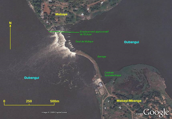
Between Bangui and Bangassou, there is a riverbreak due to Mobaye dam and waterfalls (see above picture) with width 600 m.
The “ecluse (lock)” doesn’t exist anymore.
The West Mobaye port is very basic – no infrastructure and equipment is available, while the East Mobaye port is the old port, with a jetty
used before the dam was built in the early eighties.
There are no “Baleiniere” after Mobaye –there is another riverbreak with 5/10 meters waterfalls at Ouango so the waterway toBangassou is not passable.
An evaluation is on-going between Mobaye and Ouango. The LCA will be updated accordingly.
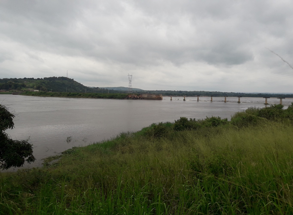
Mobaye - Dam (left) and waterfalls (right)
BALEINIERES BANGUI
|
OWNERS |
NUMBERS |
LENGTH (meter) |
TONNAGE (Mt) |
|---|---|---|---|
|
NGBOKOTO Sylvain |
1 |
25 |
60 |
|
MBERENGA Jean Baptiste |
2 |
22 – 27 |
50 – 70 |
|
GUEREYORO Moussa |
1 |
22 |
50 |
|
TITHEU Gabriel |
1 |
18 |
25 |
|
VOUMON Marie Solange |
1 |
18 |
25 |
|
MARTIAL |
1 |
18 |
25 |
|
KOSSI Jean Pierre |
1 |
22 |
50 |
|
ELIM |
1 |
18 |
25 |
|
YAMBANGUI Eulalie |
1 |
18 |
25 |
|
BOMBI Jean |
5 |
20,5 – 22 – 27 – 32 – 32 |
50 – 50 – 70 – 85 – 85 |
|
KOMBANGA Isidore |
2 |
28 – 32 |
70 – 85 |
|
MONKELELE Patrick |
2 |
25 – 27 |
60 – 70 |
|
VICKOMO Sophie |
1 |
27 |
70 |
|
KOGBIA |
1 |
18 |
25 |
|
AZOUDOALA Thomas |
1 |
30 |
80 |
|
NGBAGOPE |
1 |
25 |
60 |
|
BETENEDJI Jules |
1 |
30 |
80 |
|
MBROUKOUZOU Armand |
1 |
18 |
25 |
|
OUTOUMBILI Andre |
1 |
18 |
25 |
|
BOMBO Egide |
1 |
18 |
25 |
See 4.8 Central African Republic Port and Waterways Company Contact List
2.5 Central African Republic Storage Assessment
Overview
For information on Central African Republic Storage contact details, please see the following link:
4.4 Central African Republic Storage and Milling Company Contact List
Storage Used by Humanitarian Organizations
PUI (Premiere Urgence International), HI (Humanity & Inclusion) and Intersos are offering storage to the humanitarian community in Bangui, Bambari, Kaga Bandoro and Bossangoa.
| Location | Organisation | Sharing Possibility | Capacity | Type | Access | Condition |
| ALINDAO | COOPI | NO | 90 m³ | Concrete | Good | Good |
| ALINDAO | ACF (Logistics Cluster) | YES | 160 m² | 1 MSU | Good | Good |
| BAMBARI | IOM | NO | 320 m² | |||
| BAMBARI | WFP | YES | 2550 Mt | 6 MSU | Good | Good |
| BAMBARI | WFP | YES | 300 Mt | Concrete | Good | Good |
| BAMBARI | HI (Logistics Cluster) | YES | 320 m² | 1 MSU | Good | Good |
| BAMBARI | COOPI | NO | 600 m³ | Concrete | Good | Good |
| BAMBARI | UNHCR/ AIRD | NO | 720 m³ | 1 MSU | Good | Good |
| BAMBARI | UNICEF | NO | 75 m² | Concrete | Good | Good |
| BANGASSOU | WFP | YES | 500 Mt | 1 MSU | Good | Good |
| BANGUI | PUI (Logistics Cluster) | YES | 1440 m² | Concrete | Good | Good |
| BANGUI | PUI (Logistics Cluster) | YES | 400 m² | 2 MSU | Good | Good |
| BANGUI | WHO | NO | 60 m² | Concrete | Good | Good |
| BANGUI | WHO/ MoH | NO | 250 m² | Concrete | Good | Good |
| BANGUI | MDM | NO | 435 m³ | Concrete | Good | Good |
| BANGUI | PUI (Logistics Cluster) | YES | 200 m² | Cold Room | Good | Good |
| BANGUI | COOPI | NO | 420 m³ | Concrete | Good | Good |
| BANGUI | UNHCR/ AIRD | NO | 3000 m³ | Concrete | Good | Good |
| BANGUI | UNHCR/ AIRD | NO | 2160 m³ | 3 MSU | Good | Good |
| BANGUI | UNICEF | NO | 1750 m² | Concrete | Good | Good |
| BANGUI | UNICEF | NO | 650 m² | 2 MSU | Good | Good |
| BANGUI | UNICEF | NO | 150 m² | Cold room | Good | Good |
| BANGUI | NRC | NO | 140 m² | Concrete | Good | Good |
| BANGUI Aluba | WFP | YES | 1800 Mt | Concrete | Good | Good |
| BANGUI Base Log | WFP | YES | 4500 Mt | Concrete | Good | Good |
| BANGUI Base Log | WFP | YES | 300 Mt | 1 MSU | Good | Good |
| BOSSANGOA | HI (Logistics Cluster) | YES | 320 m² | 1 MSU | Good | Good |
| BOSSANGOA | WFP | YES | 1000 Mt | 2 MSU | Good | Good |
| BOSSANGOA | WFP | YES | 600 Mt | Concrete | Good | Good |
| BOSSANGOA | UNICEF | NO | 150 m² | Concrete | Good | Good |
| BOUAR | WFP | YES | 2300 Mt | Concrete | Good | Good |
| BOUAR | UNHCR/ AIRD | NO | 720 m³ | 1 MSU | Good | Good |
| BOUAR | UNICEF | NO | 150 m² | Concrete | Good | Good |
| BRIA | WFP | YES | 1500 Mt | 3 MSU | Good | Good |
| BRIA | COOPI | NO | 120 m³ | Concrete | Good | Good |
| CARNOT | NRC | NO | 600 m² | Concrete | Good | Good |
| KAGA BANDORO | WFP | YES | 1200 Mt | Concrete | Good | Good |
| KAGA BANDORO | INTERSOS (Logistics Cluster) | YES | 320 m² | 1 MSU | Good | Good |
| KAGA BANDORO | UNHCR/ AIRD | NO | 720 m³ | 1 MSU | Good | Good |
| KAGA BANDORO | UNICEF | NO | 420 m² | Concrete | Good | Good |
| KOUANGO | COOPI | NO | 90 m³ | Concrete | Good | Good |
| MBAIKI | COOPI | NO | 75 m³ | Concrete | Good | Good |
| OBO | WFP | YES | 500 Mt | 1 MSU | Good | Good |
| OBO | COOPI | NO | 120 m³ | Concrete | Good | Good |
| OBO | UNHCR/ AIRD | NO | 2160 m³ | 3 MSU | Good | Good |
| PAOUA | WFP | YES | 2600 Mt | 5 MSU | Good | Good |
| PAOUA | UNHCR/ AIRD | NO | 720 m³ | 1 MSU | Good | Good |
| SIBUT | NRC | NO | 900 m² | Concrete | Good | Good |
| ZEMIO | WFP | YES | 600 Mt | Concrete | Good | Good |
| ZEMIO | COOPI | NO | 120 m³ | Concrete | Good | Good |
| ZEMIO | ACTED (Logistics Cluster) | YES | 240 m² | 1 MSU | Good | Good |
Public Sector Storage
| Location | Ministry/Agency | Use possibility | Capacity | Type | Access | Condition |
|---|---|---|---|---|---|---|
|
Bangui
|
Government of C.A.R. through the CEGAL
|
-
|
2086,66 m2
|
See Annexes, Public Storage CAR
|
Good
|
Good
|
|
Bouar
|
Government of C.A.R. through the CEGAL
|
-
|
558,98 m2
|
See Annexes, Public Storage CAR
|
Good
|
Good
|
|
Paoua
|
Government of C.A.R. through the CEGAL
|
-
|
960 m2
|
See Annexes, Public Storage CAR
|
Good
|
Good
|
|
Bambari
|
Government of C.A.R. through the CEGAL
|
-
|
520.78 m2
|
See Annexes, Public Storage CAR
|
Good
|
Good
|
|
Kaga-Bandoro
|
Government of C.A.R. through the CEGAL
|
-
|
n/a
|
See Annexes, Public Storage CAR
|
Good
|
Good
|
Private Sector Storage
|
Location |
Name |
Address |
Use possibility |
Capacity |
Type |
Access |
Condition |
|
Bangui |
MBOYO Max Jacob |
Near lycee Boganda |
YES |
217 m2 |
Concrete |
Good |
Good |
|---|---|---|---|---|---|---|---|
|
Bangui |
Groupe Kamach |
PK0 |
YES |
Several w/h |
Concrete |
Good |
Good |
|
Bangui |
Bollore/ Socatraf |
Port |
YES |
Several w/h |
Concrete |
Good |
Good |
|
Bossangoa |
Charles Dei |
Eveche |
YES |
600 Mt |
Concrete |
Good |
Good |
|
Bossangoa |
Charles Dei |
Eveche |
YES |
600 Mt |
Concrete |
Good |
Good |
2.6 Central African Republic Milling Assessment
Overview
MAÏSCA (Maïserie Centrafricaine) is the only mill in the Central African Republic, established in 2003. The company’s milling facilities are located in Bangui.
For information on Central African Republic Milling contact details, please see the following link:
4.4 Central African Republic Storage and Milling Company Contact List
Milling Company: MAÏSCA
|
Company Name & Address |
Contact Names & Email |
Telephone & Fax |
|---|---|---|
|
HUSACA - MAÏSCA Bimbo constituency |
Name: Mr. Tchokam Title: Chargé de missions Email: n/a Web: n/a |
Fax: n/a |
|
Summary of Role and Services: Maize Mill
|
||
|
Security |
||
|---|---|---|
|
Security (Good / Poor) |
Good | |
|
Compound (Fenced / Not Fenced) |
Fenced | |
| Other Comments | n/a | |
|
Access |
||||||
|---|---|---|---|---|---|---|
|
Distance from main town (km) |
Bangui, 9 km |
|||||
|
Travel time if not located in town (hours) |
n/a | |||||
|
Road condition to Mill |
good | |||||
|
Road limitation (if any) Maximum Width and Max. Tonnage |
n/a |
|||||
|
Rail connections (Yes / No) |
No |
|||||
|
On the railway from |
- |
to |
- |
|||
|
Other Comments |
||||||
|
Milling Capacity (Mt) |
||
|---|---|---|
|
Commodities |
Daily Capacity (mt) |
Monthly Activity (mt) |
|
All |
60 metric tons |
24,000 metric tons (annual) |
|
Storage Capacity |
|
|---|---|
|
Storage in Metric Tonnes |
2,000 metric tons |
|
Capacity to Blend |
|---|
|
MAÏSCA installed fortification facilities and can therefore produce fortified maize meal. |
|
Transport Capacity at Mill |
|---|
|
MAÏSCA has a fleet of 6 trucks with a total loading capacity estimated around 115 metric tons. |
|
Additional Notes |
|---|
| Ratios The different ratios observed during the milling of maize grain are as follows: - Gritz: 42% - Flour for human consumption: 40% - Flour for animal consumption (provenderie): 10% - Germ: 8% Loading/Discharge Rates The average loading rate in the Central African Republic is around 700 XAF/MT. This rate should normally apply In case of purchase with MAÏSCA. |