Ghana - 2.3 Road Network
Road Network
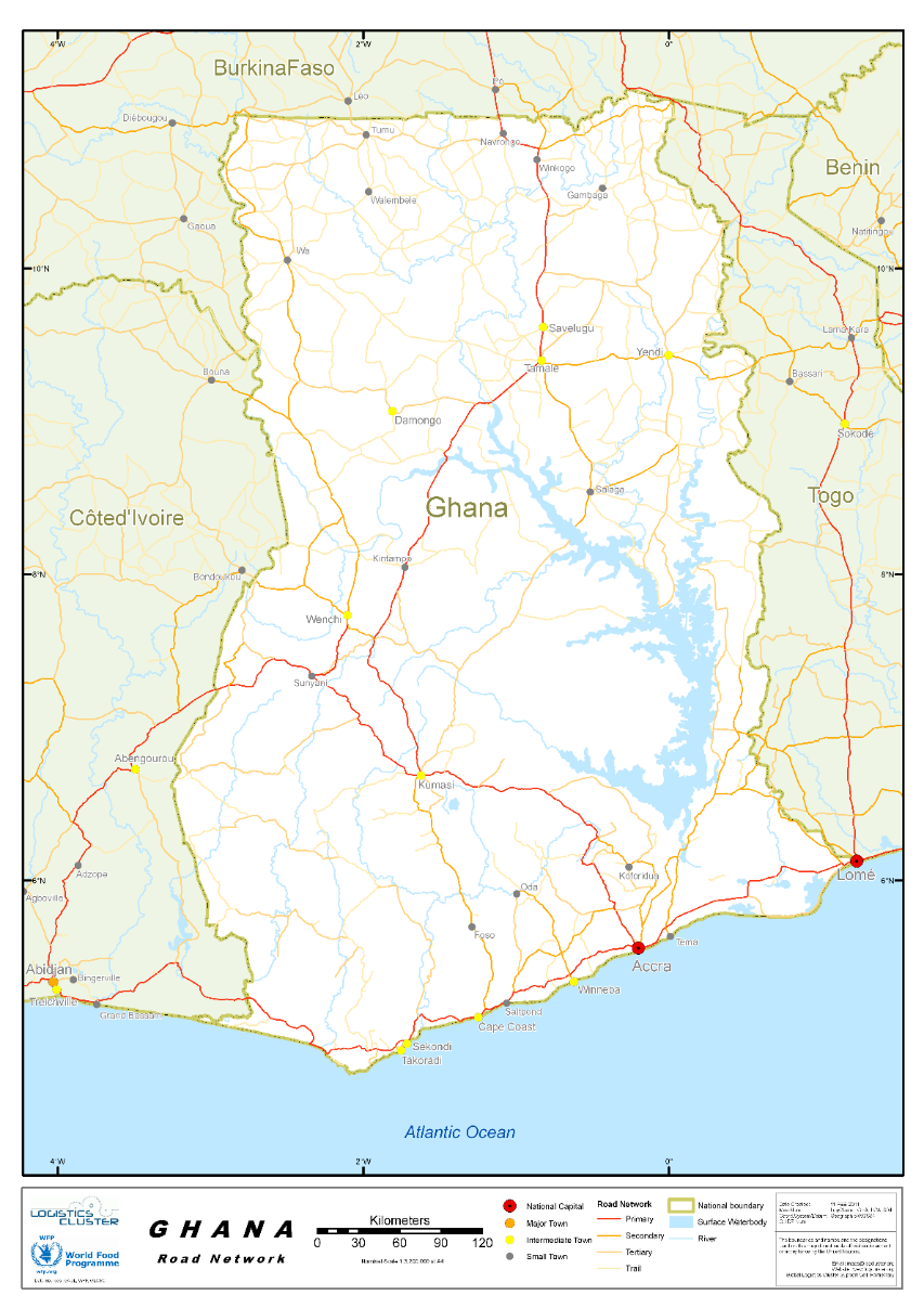
Road transport is by far the dominant carrier of freight and passengers in Ghana's land transport system. It carries over 95% of all passenger and freight traffic and reaches most communities, and is classified under three categories of trunk roads, urban roads, and feeder roads. The Ghana Highway Authority, established in 1974 was tasked with developing and maintaining the country's trunk road network.
The county’s total road network was estimated at 94,203km, with 27% paved and 73% unpaved. The interventions over the last 6 years have led to a marked improvement of Ghana’s road network to 44% good, 34% fair and 22% poor, that is, a 7% reduction in the proportion of roads in poor condition”. source
Trunk roads in Ghana are classified as “National roads”, “Regional roads”, and “Inter-regional roads”, all of which form the Ghana road network.
National roads, designated with the letter N, link all the major population centres in Ghana. Regional roads, designated with the letter R, are a mix of primary and secondary routes, which serve as feeder roads to National roads; while Inter-Regional roads, designated with the prefix IR, connect major settlements across regional borders.
With respect to this mode of transport, many people prefer to use the public means. Many of the town and cities in the country can be reached using urban buses known as "trotro" or taxis. For inter-regional transport bigger buses are normally used.
Road transport buses are the main mode of transport accounting for about 60% of passenger movement. Taxis account for only 14.5% with the remaining accounted for by private cars. One important trend in road transport (especially inter-city) is that there has been a shift from minibuses towards medium and large cars with capacities of 30-70 seats. There has been a growing preference for good buses as the sector continues to offer more options to passenger in tons of quality of vehicles used. According to the Ministry of Roads and Transport.
The Ghana road network is 94,203 km and road transportation are the most dominant choice of transportation in Ghana. Road transport infrastructure in Ghana can be used throughout to facilitate the exchange of commodities and enable regular school attendance and fast access to health facilities in Ghana. The intention is to have many of the existing highways tolled and private-sector participation in road construction and ownership.
For more information on government agency and airport company contact information, please see the following links: 4.1 Government Contact List.
Distance Matrix
Distances from Capital City to Major Towns (km)
|
|
Accra |
Bolgatanga |
Cape Coast |
Ho |
Koforidua |
Kumasi |
Sunyani |
Takoradi |
Wa |
|---|---|---|---|---|---|---|---|---|---|
|
Accra |
- |
815 |
145 |
156 |
85 |
272 |
403 |
229 |
721 |
|
Bolgatanga |
815 |
- |
765 |
567 |
742 |
543 |
588 |
823 |
275 |
|
Cape Coast |
145 |
765 |
- |
317 |
216 |
272 |
353 |
84 |
710 |
|
Ho |
156 |
567 |
317 |
- |
135 |
336 |
515 |
388 |
720 |
|
Koforidua |
85 |
742 |
216 |
135 |
- |
200 |
330 |
283 |
688 |
|
Kumasi |
272 |
543 |
272 |
336 |
200 |
- |
130 |
305 |
444 |
|
Sunyani |
403 |
588 |
353 |
515 |
330 |
130 |
- |
436 |
375 |
|
Takoradi |
229 |
823 |
84 |
388 |
283 |
305 |
436 |
- |
752 |
|
Wa |
721 |
275 |
710 |
720 |
688 |
444 |
375 |
752 |
- |
Travel Time from Capital City to Major Towns (hours)
|
|
Accra |
Bolgatanga |
Cape Coast |
Ho |
Koforidua |
Kumasi |
Sunyani |
Takoradi |
Wa |
|---|---|---|---|---|---|---|---|---|---|
|
Accra |
- |
10 |
2 |
2 |
1 |
4 |
5 |
3 |
9 |
|
Bolgatanga |
10 |
- |
10 |
7 |
9 |
7 |
7 |
10 |
4 |
|
Cape Coast |
2 |
10 |
- |
4 |
3 |
4 |
5 |
1 |
9 |
|
Ho |
2 |
7 |
4 |
- |
2 |
4 |
7 |
5 |
9 |
|
Koforidua |
1 |
9 |
3 |
2 |
- |
3 |
4 |
4 |
9 |
|
Kumasi |
4 |
7 |
4 |
4 |
3 |
- |
2 |
4 |
6 |
|
Sunyani |
5 |
7 |
5 |
7 |
4 |
2 |
- |
6 |
5 |
|
Takoradi |
3 |
10 |
1 |
5 |
4 |
4 |
6 |
- |
10 |
|
Wa |
9 |
4 |
9 |
9 |
9 |
6 |
5 |
10 |
- |
Road Security
The National Road Safety Authority (NRSA), is the lead agency for road safety management in Ghana under the Ministry of Transport. It was established by the NRSA Act, 2019 (Act 993) to develop and promote road safety, to coordinate and regulate activities, procedures and standards related to road safety and to provide for related matters.
The Act has since August 2, 2019, received presidential assent, and repeals the NRSC Act, 1999 (Act 567) that established the National Road Safety Commission. In addition to the existing mandate under the Commission of promoting best road safety practices among road users and coordinating road safety activities, the NRSA Act provides for an enhanced mandate where the Authority is now empowered to regulate, ensure implementation and enforcement of road safety standards and procedures.
With regards to the new Act, Act 2019 (Acts 993) the National Road Safety Authority is mandated to issue compliance notices to institutions or organizations who breach road safety standards.
OBJECTIF OF THE AUTHORITY
The Objectif of the Authority is to reduce the incidence of road traffic crashes, fatalities and injuries through the:
-
Promotion of road safety
-
Development and coordination of policies in relation to road safety
-
Implementation and enforcement of standards for road safety
The Key functions of the Authority under the Act 993 include the following:
-
Nationwide road safety education, campaigns and publicity.
-
Ensure the implementation and enforcement of road safety standards and procedures in addition to the earlier mandate of promoting best road safety practices among road users and coordinating road safety activities.
-
Develop a long-term plan for the promotion of road safety and the reduction of road traffic crashes, fatalities and injuries and collaborate with the Driver and Vehicle Licensing Authority, road agencies, enforcement agencies, crash response agencies and road transport service providers to implement the plan.
-
Collaborate with other relevant agencies to co-ordinate, monitor and evaluate road safety activities, programmes and strategies.
-
Issue notices in the form of directives, procedures or cautions to persons to provide or correct irregularity in procedures, standards, practices and operations to prevent or minimize road traffic crashes, fatalities and injuries.
-
Receive complaints and investigate violations of road safety standards, Regulations and best practices and advise the Minister on the measures required to prevent or minimize road safety risks.
-
Ensure institutional compliance with procedures and standards related to road safety.
-
Collaborate with the Ghana Education Service and other relevant bodies to develop road safety education as part of the curriculum for pre-tertiary level schools and colleges of education.
-
Collaborate with the Building and Road Research Institute, the Ghana Standards Authority and other bodies with relevant knowledge and expertise in road safety to develop standards for road safety equipment and ensure compliance.
-
Regulate road transport and related services.
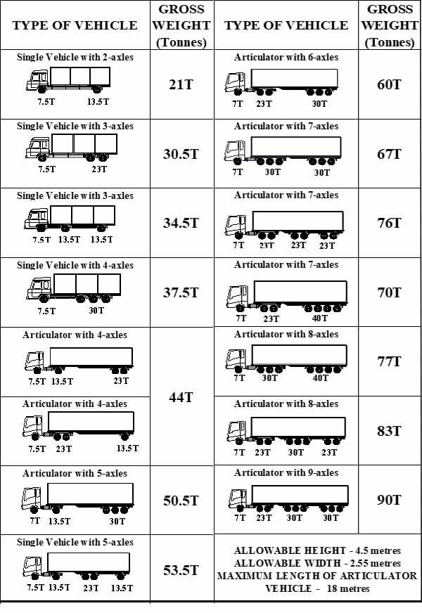
Weighbridges and Axle Load Limits
Axle load control and management is a critical issue for all the countries in the sub-region since excessive loading of trucks is one of the causes of early deterioration of the roads. The Supplementary Act Act/SP.17/02/12 relating to the Harmonisation of Standards and Procedures for the Control of Dimensions, Weigh and Axle Load of Goods Vehicle within Member States of the Economic Community of West African States was approved by the HoSG in Abuja 16-17 February 2012. Ghana commenced its program in earnest in June 2009 as part of an agreement with WAEMU countries. The sector has been implementing the Axle Load Control and management in accordance with the Road Traffic Act 683 and the Road Traffic Regulations 2012 (LI 2180) which has incorporated sections of the ECOWAS Supplementary Act. Intensive education and sensitization on the new regulation has been undertaken. Key stakeholders such as Freight Forwarders, Haulers, Truckers, Ports, Private Weighbridge Station Operators have been involved in this sensitization programme under the Axle Load Working group chaired by the Ministry of Roads and Highways. The current allowable load limit in Ghana is 60 tones even though authorities say they are working gradually to achieve a 51 tons maximum load limit in the very near future. The allowable height is 4.5 metres and allowable width is 2.55 metres.
PERMISSIBLE AXLE LOAD, GROSS WEIGHT AND DIMENSION LIMITS
|
Axle load limits |
Ghana |
Togo |
ECOWAS |
|---|---|---|---|
|
Truck with 2 axles |
21 mt |
23 mt |
18 mt |
|
Truck with 3 axles |
30.5 mt |
34 mt |
26 mt |
|
Truck with 4 axles |
37.5 mt |
41 mt |
31 mt |
|
Semi-trailer with 3 axles |
34.5 mt |
39 mt |
30 mt |
|
Semi-trailer with 4 axles |
44 mt |
50 mt |
38 mt |
|
Semi-trailer with 5 axles |
50.5 mt |
50 mt |
43 mt |
|
Semi-trailer with 6 axles |
60 mt |
68 mt |
51 mt |
|
Truck & drawbar trailer with 4 axles |
44 mt |
50 mt |
38 mt |
|
Truck & drawbar trailer with 5 axles |
50.5 mt |
61 mt |
46 mt |
|
Truck & drawbar trailer with 6 axles |
60 mt |
68 mt |
51 mt |
|
Truck & drawbar trailer with 7 axles |
60 mt |
n/a |
n/a |
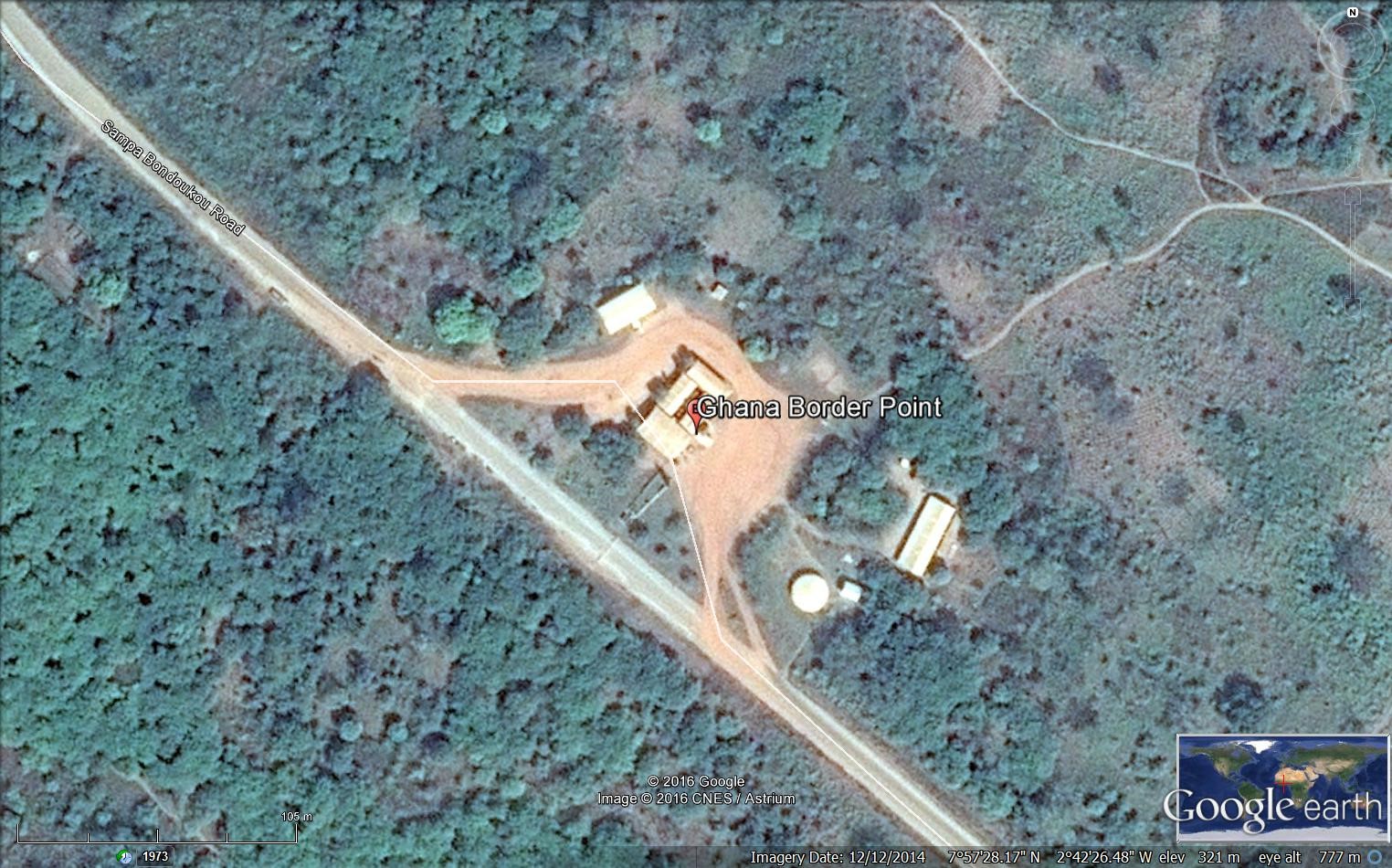
Ghana - 2.3.1 Border Crossing of Sampa
Land Border Crossing Overview:
Sampa is a town in the Brong-Ahafo Region of Ghana, on the border with Côte d'Ivoire. It is the capital of Jaman North District and was formerly the site of a slave market. It is the biggest border town in Ghana with a population of over 36,000. There are 8 entry points in the region, but Sampa is the biggest entry point to the northern of Ivory Coast.
|
BORDER CROSSING LOCATION & CONTACT |
|
|---|---|
|
Name of Border Crossing: (If crossing has a different name in each country, please indicate in the following format: Name [Country]/Name[Country]) |
Sampa [Ghana] / Soko [Ivory Coast] |
|
Province or District: |
Western Region / Brong-Ahafo |
|
Nearest Town or City: (Nearest location with distance from port) |
Sampa 3 (km) |
|
Latitude: |
7°58'18.1"N |
|
Longitude: |
2°43'08.0"W |
|
Managing Authority/Agency: |
Customs Division |
|
Contact number |
+233244374266 |
|
Travel Times |
|
|---|---|
|
Nearest International Airport: |
Bondoukou in Ivory Coast 13 (km) Truck: 1 hour Car: 15 minutes |
|
Nearest Port: |
Tema in Ghana 520 (km) Truck: 14 Car: 8 hours |
|
Nearest Major Market: (Nearest location with functioning wholesale markets, or with significant manufacturing or production capacity.) |
Sampa on Mondays 3 (km) Truck: 10 minutes Car: 5 minutes |
|
Other Information: (Please provide additional details of this route if relevant, such as information about whether there are fuelling stations or weighing bridges en-route.)
|
There are 7 fuelling stations in Sampa. There aren’t any weighing bridges en route. |
|
Hours of Operation |
|
|---|---|
|
MONDAYS |
06:00 – 18:00 |
|
TUESDAYS |
06:00 – 18:00 |
|
WEDNESDAYS |
06:00 – 18:00 |
|
THURSDAYS |
06:00 – 18:00 |
|
FRIDAYS |
06:00 – 18:00 |
|
SATURDAYS |
06:00 – 18:00 |
|
SUNDAYS |
06:00 – 18:00 |
|
NATIONAL HOLIDAYS: (List dates of closure and hours of operation if different from regular schedule.) |
No dates of closure during the year. |
|
SEASONAL CONSTRAINTS: (i.e., winter months, rainy season, etc.) |
During the rainy season from May to September. |
Daily Capacity:
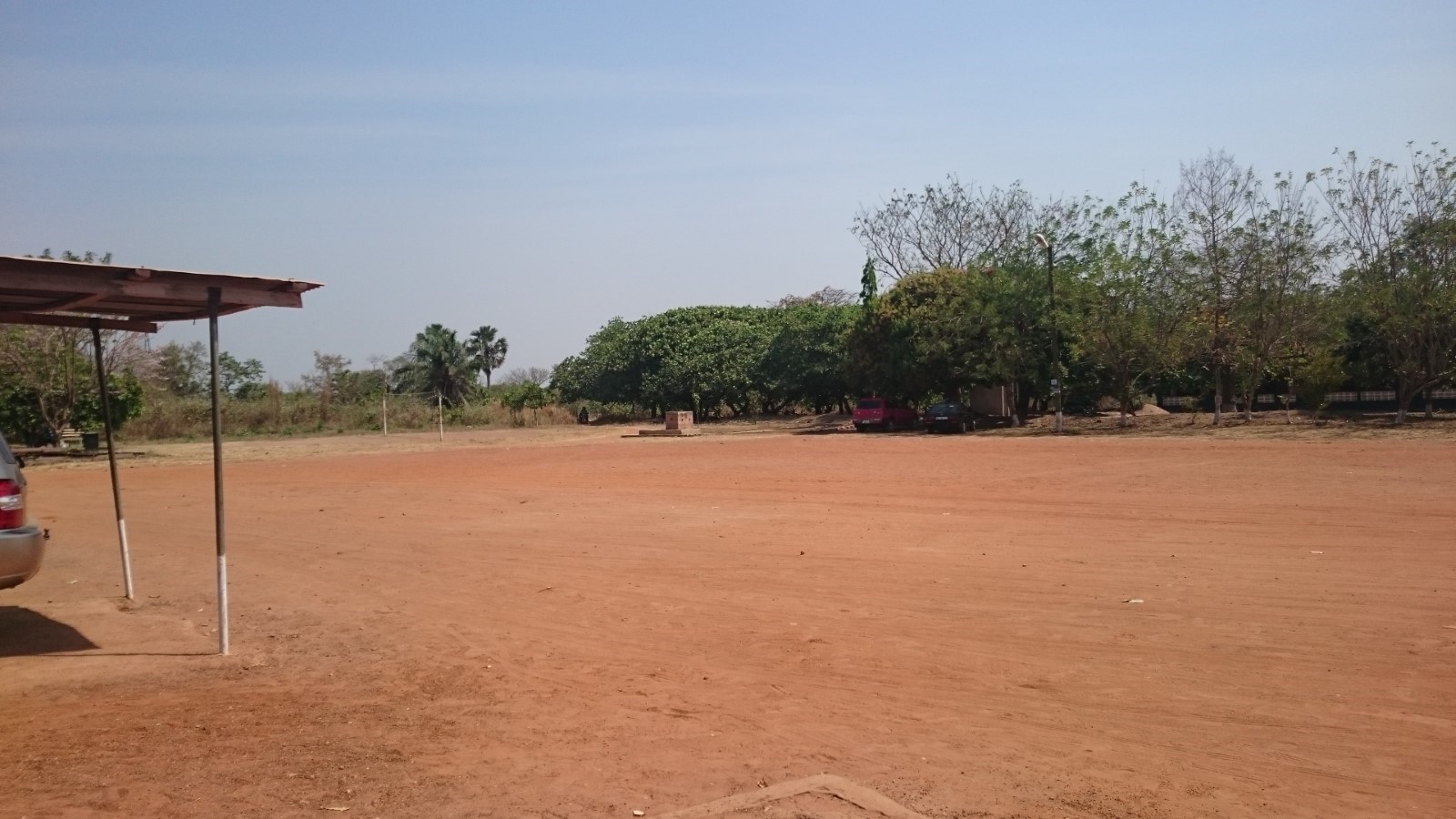
There isn’t any lane for private car. A parking area is available at the site with security during the night. Around 10 trucks cross the border on daily basis in both ways and around 20 private vehicles.
Customs Clearance:
The Post is not computerized but uses the manual method. For the exportation: A custom document titled ‘Non-Traditional Export Form’ should be filled by the exporter. The customs process the document made in 10 copies; 1 for the exporter, 1 for the Customs, 1 for the Ministry of Trade, 1 for the Ministry of Finance, 1 for the Statistical Services, 1 for the Customs HQ and 1 for the Ministry concerned. For the importation, the truck and cargo should be accompanied by Proforma Invoice which is considered the ‘Bill of Lading’, the Waybill, packing list. For the food imported, the representative of the Ministry of Agriculture should approve the consignment. There is lab available at Sunyama where a sample of the cargo will be examined. Depending on the feedback from the lab, the Ministry of Agriculture issues an import certificate to be joined to the documents. The consignment then could be released from the Customs. The process takes 1 day or 2 days depending on the information. All foreign trucks must enter with a temporary importation certificate. There is only one inspection conducted on the truck and the cargo with the presence of all the representatives of the ministries concerned. The customs duties if applicable are paid at the post in cash.
Other Relevant Information:
Trucks need to wait 1 day to 2 days depending on the information from the outside. Only one inspection is conducted on the truck and cargo. The importation of medicines requires an importation permit from the Ministry of Health and if livestock then a health permit is needed from the Vet. Services.
For more information on government agency and airport company contact information, please see the following links: 4.1 Government Contact List.
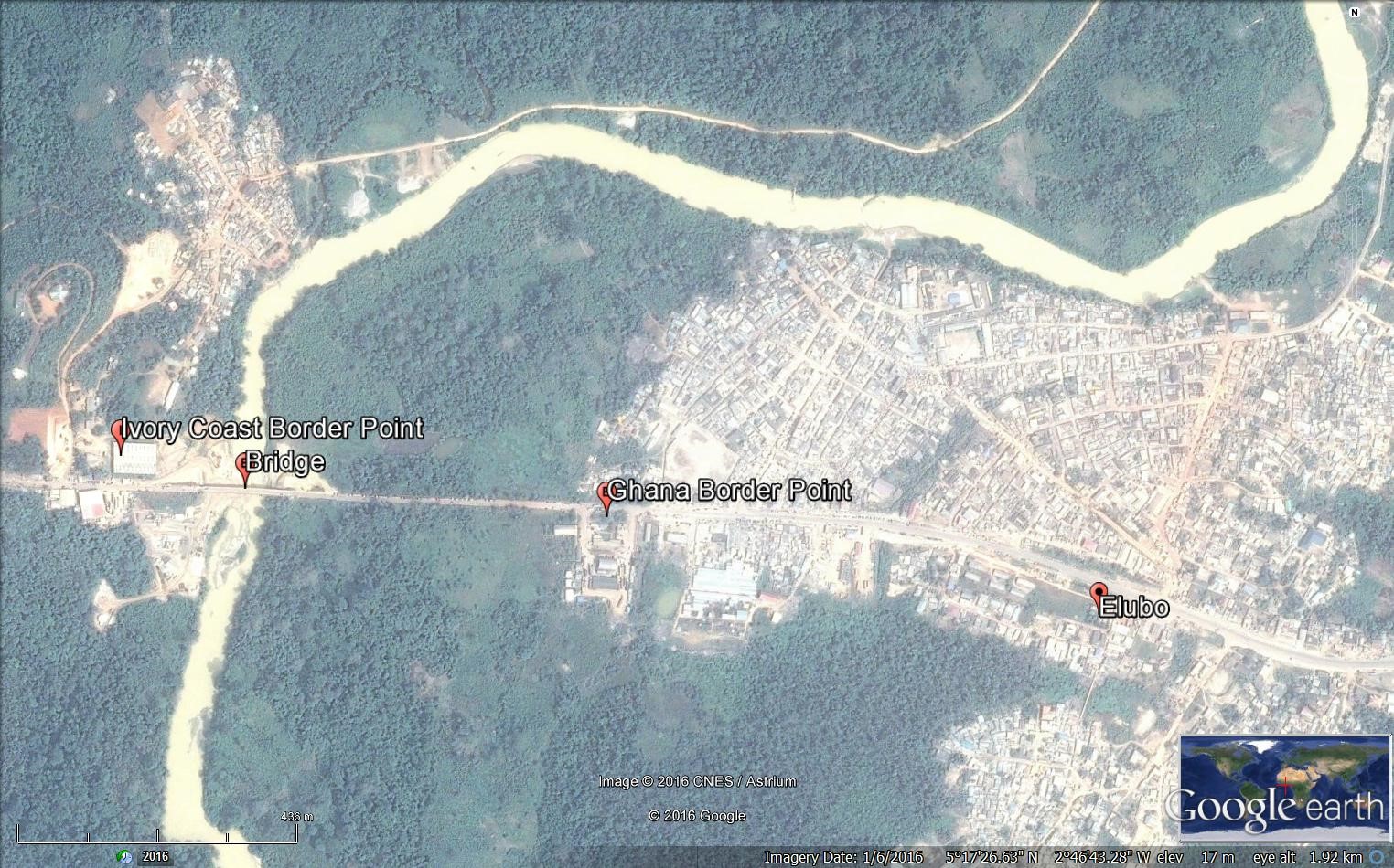
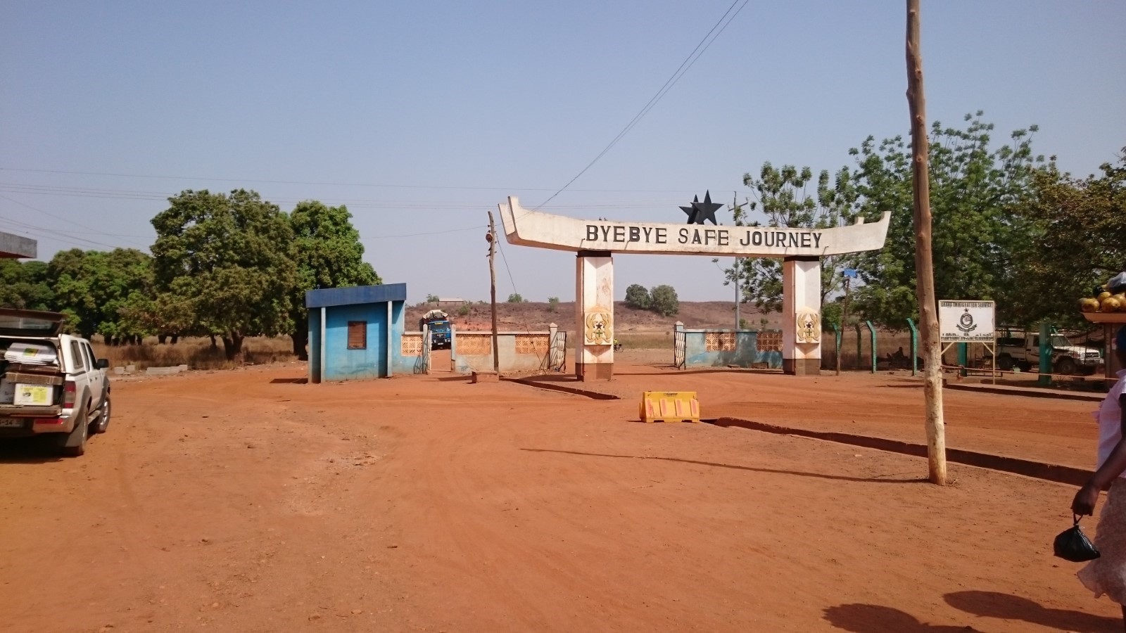
Ghana - 2.3.2 Border Crossing of Elubo
Land Border Crossing Overview:
Elubo is a village in the Jomoro district, a district in the Western Region of Ghana and is the main border crossing between Ghana and Cote d'Ivoire to the west. There are two additional customs entry points, the very remote post of Oseekodwokrom, and farther north, the town of Gonnokuram, on the road to Sunyani. The road to Elubo is paved and in good condition. At all land crossings, a visa is required for non-ECOWAS citizens. There is a bridge to cross the river separating the two countries.
|
BORDER CROSSING LOCATION & CONTACT |
|
|---|---|
|
Name of Border Crossing:
|
Elubo [Ghana] / Noe [Ivory Coast] |
|
Province or District: |
Western Region / Jomoro |
|
Nearest Town or City: (Nearest location with distance from port) |
Takoradi 145 (km) |
|
Latitude: |
5° 17’ 20.37’’ N |
|
Longitude: |
2° 46’ 46.44’’ W |
|
Managing Authority/Agency: |
Ghana Revenue Authority – Customs Division |
|
Contact number |
+233244541888 |
|
Travel Times |
|
|---|---|
|
Nearest International Airport: |
Kotoka International Airport in Accra 362 (km) Truck: 8 hours Car: 6 hours |
|
Nearest Port: |
Takoradi 145 (km) Truck: 3 hours Car: 2 hours |
|
Nearest Major Market: (Nearest location with functioning wholesale markets, or with significant manufacturing or production capacity.) |
Elubo 1 (km) Truck: 10 min Car: 10 min |
|
Other Information: (Please provide additional details of this route if relevant, such as information about whether there are fuelling stations or weighing bridges en-route.)
|
There are fuelling stations and weighing bridges enroute. |
|
Hours of Operation |
|
|---|---|
|
MONDAYS |
0600 - 1800 |
|
TUESDAYS |
0600 - 1800 |
|
WEDNESDAYS |
0600 - 1800 |
|
THURSDAYS |
0600 - 1800 |
|
FRIDAYS |
0600 - 1800 |
|
SATURDAYS |
0600 - 1800 |
|
SUNDAYS |
0600 - 1800 |
|
NATIONAL HOLIDAYS: (List dates of closure and hours of operation if different from regular schedule.) |
Idem. No closing during the national holidays. |
|
SEASONAL CONSTRAINTS: (i.e., winter months, rainy season, etc.) |
No seasonal constraints. |
Daily Capacity:
Private cars are not provided a separate lane. This border deals with a high level of traffic as it is the only crossing point for transit trucks to Ivory Coast.
Customs Clearance:
Requirements for customs clearance: 1. Original Bill of Lading/Airway Bill 2. Invoice 3. Packing List 4. Final Classification and Valuation Report (FCVR) 5. Import Declaration Form (IDF) from the Ministry of Trade and Industry. 6. Tax Clearance certificate from the Domestic Tax Revenue Division issued in the name of the importer or 1% of CIF payment fee. 7. Tax Identification Number (TIN) from the Ghana Revenue Authority. 8. Permit or License from the appropriate Ministry/ Agency Department / as applicable for restricted goods. 9. Appropriate letter of Exemption from payment of duty and/or taxes as applicable.
Other Relevant Information:
The waiting time for crossing might vary depending on the traffic. Goods are subject to one inspection by the customs authority. Foreign cargo vehicles entering Ghana must obtain a temporary importation permit. Customs issues this document, called a “laissez passer/C59,” at the border. The permit is valid for 30 days. If it expires, drivers must return with the vehicle to the same border entry to renew it. The maximum renewal period that may be granted is 90 days. Customs will require drivers to produce the following documents in order to process the C59 form: • An international driver’s licence • ECOWAS Brown Card
For more information on government agency and airport company contact information, please see the following links: 4.1 Government Contact List.
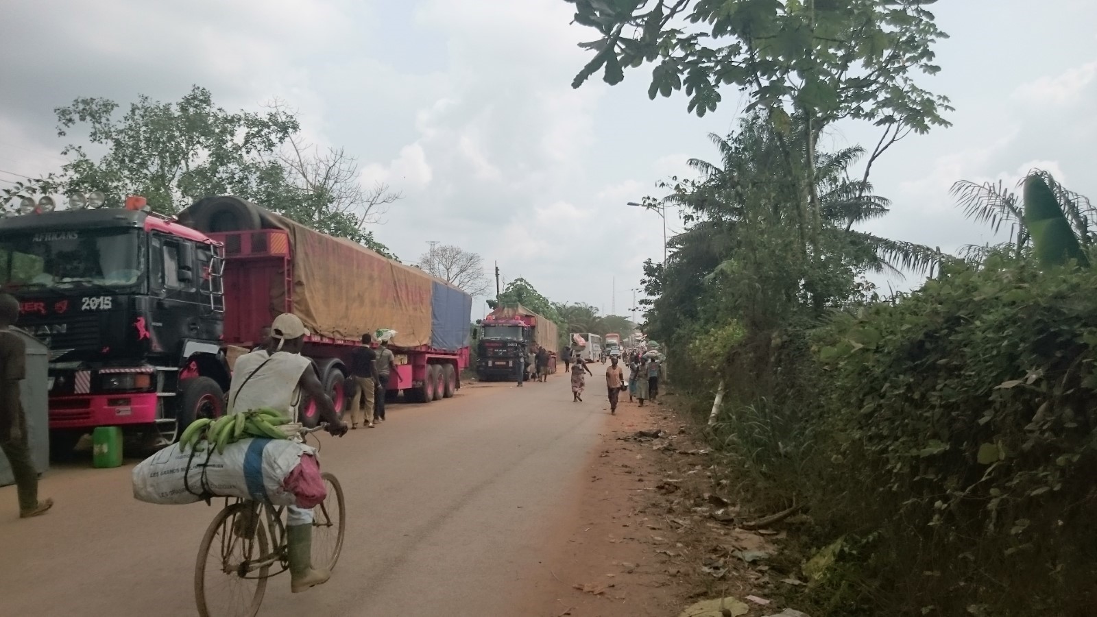
Figure 1 The road between the two border points
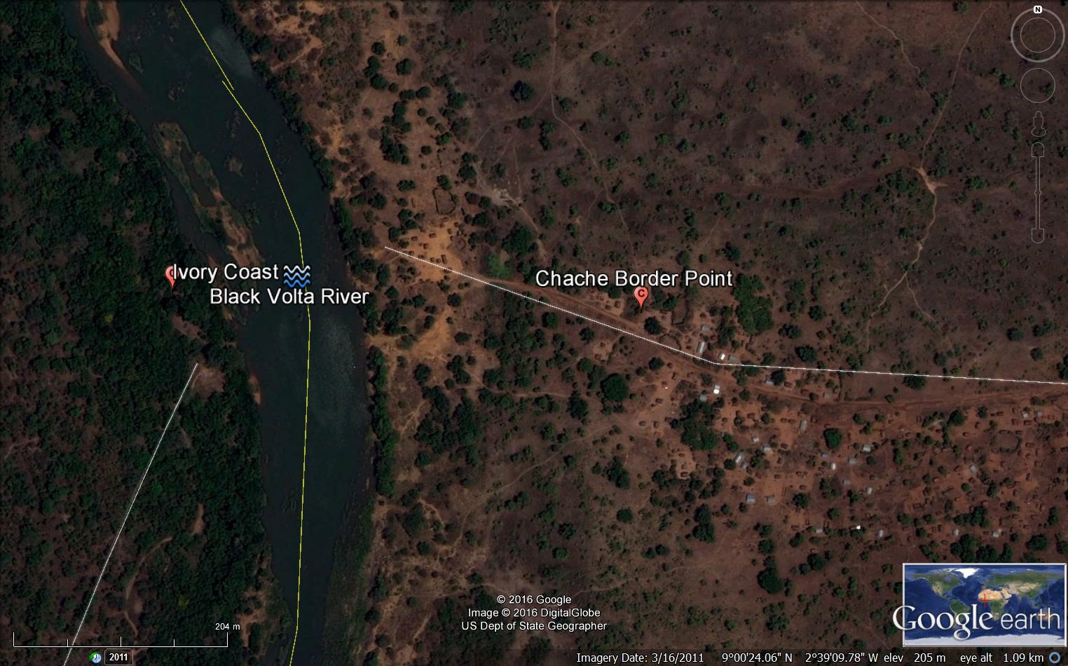
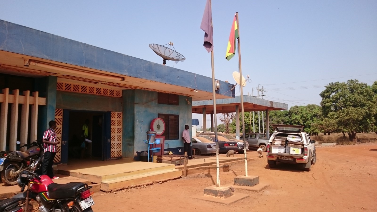
Ghana - 2.3.3 Border Crossing of Vankrogu Chache
Land Border Crossing Overview:
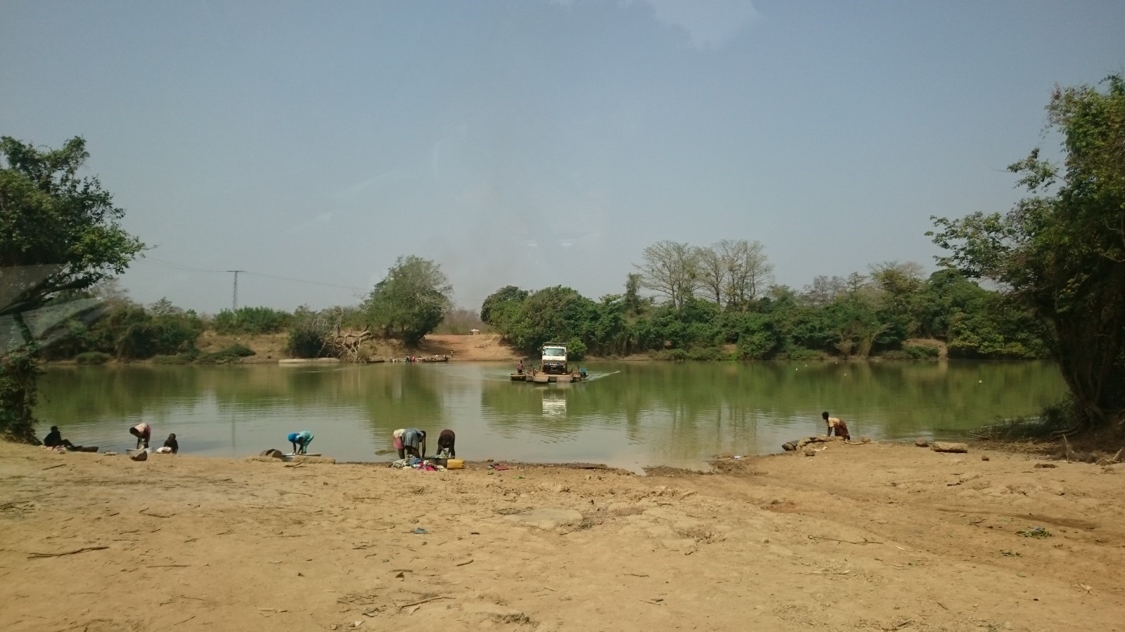
Chache is a small and basic land border crossing between Ghana and Ivory Coast. All the documents should be finalized at Bole Customs Division office prior to reaching this point. There is a small ferry with a capacity of less than 10 mt to cross the Black Volta River. There is a weekly rotation for the officers in charge who are based in Bole. At the border there are Immigration officer, Health officer, Agric. Officer in addition to the customs officer.
|
BORDER CROSSING LOCATION & CONTACT |
|
|---|---|
|
Name of Border Crossing: (If crossing has a different name in each country, please indicate in the following format: Name[Country]/Name[Country]) |
Vankrogu Chache [Ghana] / Bouna [Ivory Coast] |
|
Province or District: |
Bole District in the Northern Region |
|
Nearest Town or City: (Nearest location with distance from port) |
Bole 36 (km) |
|
Latitude: |
9° 00’24.25’’ N |
|
Longitude: |
2° 39’ 06.56’’ W |
|
Managing Authority/Agency: |
Ghana Revenue Authority – Customs Division |
|
Contact number |
+233244572706 |
|
Travel Times |
|
|---|---|
|
Nearest International Airport: |
Kokota International Airport 597 (km) Truck: 12 hours Car: 8 hours |
|
Nearest Port: |
Takoradi Port 625 (km) Truck: 12 hours Car: 8 hours |
|
Nearest Major Market: (Nearest location with functioning wholesale markets, or with significant manufacturing or production capacity.) |
Bole 36 (km) Truck: 2 hours Car: 1 hour |
|
Other Information: (Please provide additional details of this route if relevant, such as information about whether there are fuelling stations or weighing bridges en-route.)
|
There aren’t any weighing bridges in route. The fuelling stations are available near Bole town. |
|
Hours of Operation |
|
|---|---|
|
MONDAYS |
0600 - 1800 |
|
TUESDAYS |
0600 - 1800 |
|
WEDNESDAYS |
0600 - 1800 |
|
THURSDAYS |
0600 - 1800 |
|
FRIDAYS |
0600 - 1800 |
|
SATURDAYS |
0600 - 1800 |
|
SUNDAYS |
0600 - 1800 |
|
NATIONAL HOLIDAYS: (List dates of closure and hours of operation if different from regular schedule.) |
0600 - 1800. No closing during national holidays. |
|
SEASONAL CONSTRAINTS: (i.e., winter months, rainy season, etc.) |
During the rainy season, this border point can be difficult to access. |
Daily Capacity:
Private cars are not provided a separate lane. This border sees more pedestrians crossing the border than vehicles.
Customs Clearance:
All the procedures should be done at Bole Customs Division. The Requirements for customs clearance: 1. Original Bill of Lading/Airway Bill 2. Invoice 3. Packing List 4. Final Classification and Valuation Report (FCVR) 5. Import Declaration Form (IDF) from the Ministry of Trade and Industry. 6. Tax Clearance certificate from the Domestic Tax Revenue Division issued in the name of the importer or 1% of CIF payment fee. 7. Tax Identification Number (TIN) from the Ghana Revenue Authority. 8. Permit or License from the appropriate Ministry/ Agency Department / as applicable for restricted goods. 9. Appropriate letter of Exemption from payment of duty and/or taxes as applicable.
Other Relevant Information:
The waiting time for crossing might vary depending on the traffic as there is only one small ferry. Goods are subject to two inspections by the customs authority and Quarantine authority. Foreign cargo vehicles entering Ghana must obtain a temporary importation permit. Customs issues this document, called a “laissez passer/C59,” at the border. The permit is valid for 30 days. If it expires, drivers must return with the vehicle to the same border entry to renew it. The maximum renewal period that may be granted is 90 days. Customs will require drivers to produce the following documents in order to process the C59 form: • An international driver’s license • ECOWAS Brown Card
For more information on government agency and airport company contact information, please see the following links: 4.1 Government Contact List.
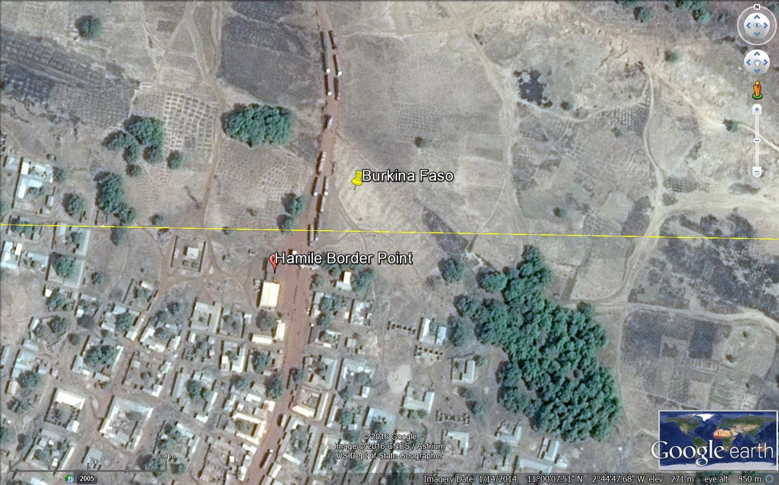
Ghana - 2.3.4 Border Crossing of Hamile
Land Border Crossing Overview:
While there are many informal points of crossing along Ghana's northern border with Burkina Faso, there are only two recognized customs entry posts. The main post is at Paga in the Northeast Region, while there is a less used entry point at Hamile in the north-western corner of Ghana. This post is computerized. There aren’t any laboratories available at this post so all the samples should go to WA which might take several days to receive the results. The trucks stay at the Free zone area as there aren’t any warehouses available.
|
BORDER CROSSING LOCATION & CONTACT |
|
|---|---|
|
Name of Border Crossing: (If crossing has a different name in each country, please indicate in the following format: Name[Country]/Name[Country]) |
Hamile [Ghana] / Ouessa [Burkina Faso] |
|
Province or District: |
Upper West Region |
|
Nearest Town or City: (Nearest location with distance from port) |
Hamile 1 (km) |
|
Latitude: |
11° 00’ 06.86’ N |
|
Longitude: |
2° 44’ 50.88’’ W |
|
Managing Authority/Agency: |
Ghana Revenue Authority – Customs Division |
|
Contact number |
+233240654400 |
|
Travel Times |
|
|---|---|
|
Nearest International Airport: |
Kotoka International Airport 810 (km) Truck: 18 hours Car: 12 hours |
|
Nearest Port: |
Tema Port 836 (km) Truck: 18 hours Car: 12 hours |
|
Nearest Major Market: (Nearest location with functioning wholesale markets, or with significant manufacturing or production capacity.) |
Hamile 1 (km) Truck: 5 minutes Car: 5 minutes |
|
Other Information: (Please provide additional details of this route if relevant, such as information about whether there are fuelling stations or weighing bridges en-route.)
|
There aren’t any weighing bridges in the region. Fuelling stations are available along the road. |
|
Hours of Operation |
|
|---|---|
|
MONDAYS |
0600 - 1800 |
|
TUESDAYS |
0600 - 1800 |
|
WEDNESDAYS |
0600 - 1800 |
|
THURSDAYS |
0600 - 1800 |
|
FRIDAYS |
0600 - 1800 |
|
SATURDAYS |
0600 - 1800 |
|
SUNDAYS |
0600 - 1800 |
|
NATIONAL HOLIDAYS: (List dates of closure and hours of operation if different from regular schedule.) |
0600 - 1800 |
|
SEASONAL CONSTRAINTS: (i.e., winter months, rainy season, etc.) |
The road network to Hamile is bad and is affected by the harvest season from September to November. |
Daily Capacity:
Private cars are not provided a separate lane. The post treats around 60 – 70 trucks per day.
Customs Clearance:
Requirements for customs clearance: 1. Original Bill of Lading/Airway Bill 2. Invoice 3. Packing List 4. Final Classification and Valuation Report (FCVR) 5. Import Declaration Form (IDF) from the Ministry of Trade and Industry. 6. Tax Clearance certificate from the Domestic Tax Revenue Division issued in the name of the importer or 1% of CIF payment fee. 7. Tax Identification Number (TIN) from the Ghana Revenue Authority. 8. Permit or License from the appropriate Ministry/ Agency Department / as applicable for restricted goods. 9. Appropriate letter of Exemption from payment of duty and/or taxes as applicable.
Other Relevant Information:
The waiting time for crossing might vary depending on the traffic. Goods are subject to several inspections by the different agencies operating at the post. Foreign cargo vehicles entering Ghana must obtain a temporary importation permit. Customs issues this document, called a “laissez passer/C59,” at the border. The permit is valid for 30 days. If it expires, drivers must return with the vehicle to the same border entry to renew it. The maximum renewal period that may be granted is 90 days. Customs will require drivers to produce the following documents in order to process the C59 form: • An international driver’s license • ECOWAS Brown Card
For more information on government agency and airport company contact information, please see the following links: 4.1 Government Contact List.
Ghana - 2.3.5 Border Crossing of Tumu
Land Border Crossing Overview:
Tumu is a small town and is the capital of Sissala East district, a district in the Upper West Region of north Ghana. Tumu is connected by road to the town of Navrongo. This Border Point is not considered as one of the main entry/exit points.
|
BORDER CROSSING LOCATION & CONTACT |
|
|---|---|
|
Name of Border Crossing: (If crossing has a different name in each country, please indicate in the following format: Name[Country]/Name[Country]) |
Tumu [Ghana] / Leo [Burkina Faso] |
|
Province or District: |
Upper West |
|
Nearest Town or City: (Nearest location with distance from port) |
Tumu 3 (km) |
|
Latitude: |
10° 53’ 37.76’’ N |
|
Longitude: |
1° 59’ 17.48’’ W |
|
Managing Authority/Agency: |
National Revenue Authority – Customs Division |
|
Contact number |
+233246332297 |
|
Travel Times |
|
|---|---|
|
Nearest International Airport: |
Kotoka International Airport 920 (km) Truck: 18 hours Car: 14 hours |
|
Nearest Port: |
Tema Port 943 (km) Truck: 18 hours Car: 14 hours |
|
Nearest Major Market: (Nearest location with functioning wholesale markets, or with significant manufacturing or production capacity.) |
Tumu (every five days) 3 (km) Truck: 10 min Car: 5 min |
|
Other Information: (Please provide additional details of this route if relevant, such as information about whether there are fuelling stations or weighing bridges en-route.)
|
Fuelling stations are available in Tumu and en-route. No weighing bridges. |
|
Hours of Operation |
|
|---|---|
|
MONDAYS |
0600 – 1800 |
|
TUESDAYS |
0600 – 1800 |
|
WEDNESDAYS |
0600 – 1800 |
|
THURSDAYS |
0600 – 1800 |
|
FRIDAYS |
0600 – 1800 |
|
SATURDAYS |
0600 – 1800 |
|
SUNDAYS |
0600 – 1800 |
|
NATIONAL HOLIDAYS: (List dates of closure and hours of operation if different from regular schedule.) |
0600 – 1800. No closing during holidays. |
|
SEASONAL CONSTRAINTS: (i.e., winter months, rainy season, etc.) |
The road condition is poor during the rainy season. |
Daily Capacity:
Private cars are not provided a separate lane. Not many trucks pass through this point as not considered an international crossing post.
Customs Clearance:
Requirements for customs clearance: 1. Original Bill of Lading/Airway Bill 2. Invoice 3. Packing List 4. Final Classification and Valuation Report (FCVR) 5. Import Declaration Form (IDF) from the Ministry of Trade and Industry. 6. Tax Clearance certificate from the Domestic Tax Revenue Division issued in the name of the importer or 1% of CIF payment fee. 7. Tax Identification Number (TIN) from the Ghana Revenue Authority. 8. Permit or License from the appropriate Ministry/ Agency Department / as applicable for restricted goods. 9. Appropriate letter of Exemption from payment of duty and/or taxes as applicable. An additional document is required at the border points not equipped with computers which is called SAD Forms (Self-Assessment Declaration).
Other Relevant Information:
The waiting time for crossing might vary depending on the traffic and the information needed. Goods are subject to one inspection by the customs authority. Transit trucks are not accepted in this border point. Foreign cargo vehicles entering Ghana must obtain a temporary importation permit. Customs issues this document, called a “laissez passer/C59,” at the border. The permit is valid for 30 days. If it expires, drivers must return with the vehicle to the same border entry to renew it. The maximum renewal period that may be granted is 90 days. Customs will require drivers to produce the following documents in order to process the C59 form: • An international driver’s licence • ECOWAS Brown Card
For more information on government agency and airport company contact information, please see the following links: 4.1 Government Contact List.
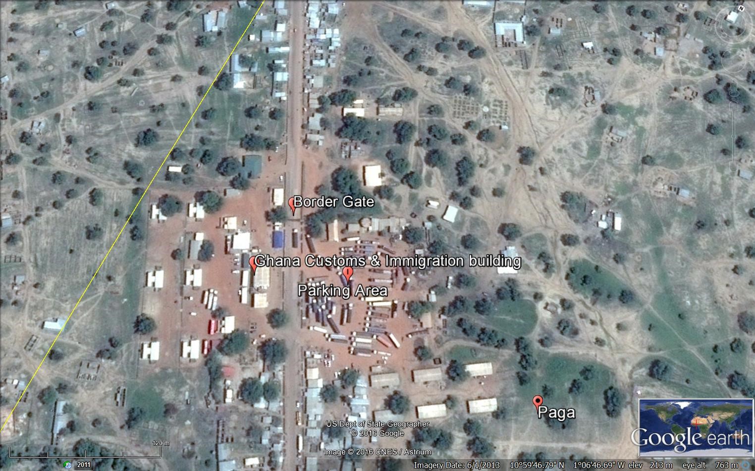
Ghana - 2.3.6 Border Crossing of Paga
Land Border Crossing Overview:
While there are many informal points of crossing along Ghana's northern border with Burkina Faso, there are only two recognized customs entry posts. The main post is at Paga in the Northeast Region, while there is a less used entry point at Hamale in the northwestern corner of Ghana.
|
BORDER CROSSING LOCATION & CONTACT |
|
|---|---|
|
Name of Border Crossing: (If crossing has a different name in each country, please indicate in the following format: Name[Country]/Name[Country]) |
Paga [Ghana] / Dakola [Burkina Faso] |
|
Province or District: |
Upper East Region |
|
Nearest Town or City: (Nearest location with distance from port) |
Navrongo 28 (km) |
|
Latitude: |
10° 59’ 45.40’’ N |
|
Longitude: |
1° 06’ 49.12’’ W |
|
Managing Authority/Agency: |
Ghana Revenue Authority – Customs Division |
|
Contact number |
+233242133766 |
|
Travel Times |
|
|---|---|
|
Nearest International Airport: |
Kotoka International Airport 938 (km) Truck: 18 hours Car: 12 hours |
|
Nearest Port: |
Tema Port 922 (km) Truck: 18 hours Car: 12 hours |
|
Nearest Major Market: (Nearest location with functioning wholesale markets, or with significant manufacturing or production capacity.) |
Navrongo 28(km) Truck: 1 hour Car: ½ hour |
|
Other Information: (Please provide additional details of this route if relevant, such as information about whether there are fuelling stations or weighing bridges en-route.)
|
There are fuelling stations enroute but not weighing bridges. |
|
Hours of Operation |
|
|---|---|
|
MONDAYS |
0600 – 1800 |
|
TUESDAYS |
0600 - 1800 |
|
WEDNESDAYS |
0600 - 1800 |
|
THURSDAYS |
0600 - 1800 |
|
FRIDAYS |
0600 - 1800 |
|
SATURDAYS |
0600 - 1800 |
|
SUNDAYS |
0600 - 1800 |
|
NATIONAL HOLIDAYS: (List dates of closure and hours of operation if different from regular schedule.) |
Regular working hours. |
|
SEASONAL CONSTRAINTS: (i.e., winter months, rainy season, etc.) |
Regular working hours. |
Daily Capacity:
Private cars are not provided a separate lane. This border deals with a high level of traffic as it is the only crossing point for transit trucks to Ivory Coast.
Customs Clearance:
Requirements for customs clearance: 1. Original Bill of Lading/Airway Bill 2. Invoice 3. Packing List 4. Final Classification and Valuation Report (FCVR) 5. Import Declaration Form (IDF) from the Ministry of Trade and Industry. 6. Tax Clearance certificate from the Domestic Tax Revenue Division issued in the name of the importer or 1% of CIF payment fee. 7. Tax Identification Number (TIN) from the Ghana Revenue Authority. 8. Permit or License from the appropriate Ministry/ Agency Department / as applicable for restricted goods. 9. Appropriate letter of Exemption from payment of duty and/or taxes as applicable.
Other Relevant Information:
The waiting time for crossing might vary depending on the traffic. Goods are subject to one inspection by the customs authority. Foreign cargo vehicles entering Ghana must obtain a temporary importation permit. Customs issues this document, called a “laissez passer/C59,” at the border. The permit is valid for 30 days. If it expires, drivers must return with the vehicle to the same border entry to renew it. The maximum renewal period that may be granted is 90 days. Customs will require drivers to produce the following documents in order to process the C59 form: • An international driver’s license • ECOWAS Brown Card
For more information on government agency and airport company contact information, please see the following links: 4.1 Government Contact List.