2.3 Egypt Road Network
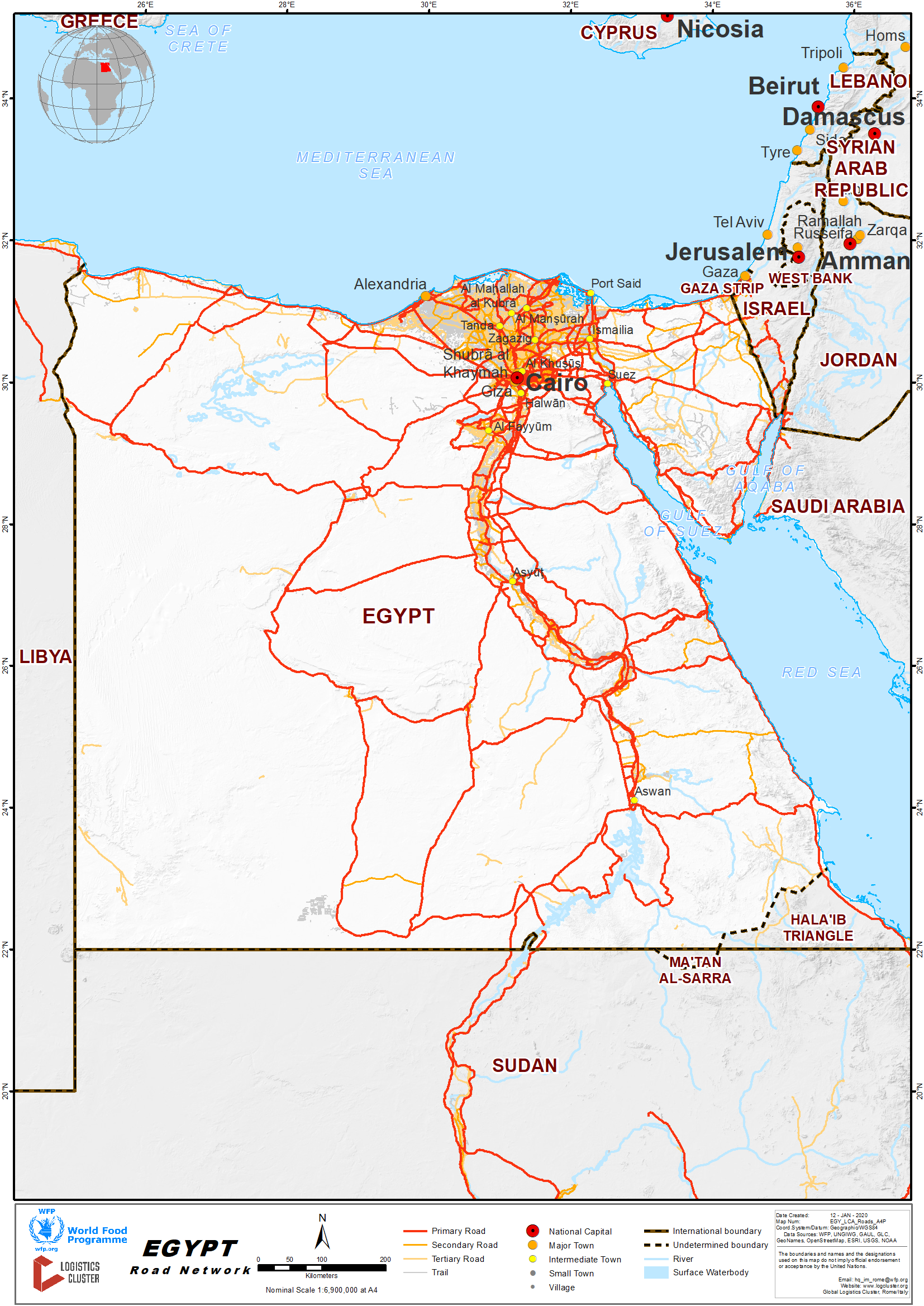
Egypt has a huge road network of 65,050km (of which 48,000km paved and 17,050km unpaved). Egypt has built a network of highways covering the country and extending around 18,000km. Two highways connect Cairo with Alex. Other highways connect Cairo to Port-Said, Suez, and El Fayoum. The total length of highways is 18,000km.
Egypt also boasts a network of bridges, which contributes to smoothing the flow of traffic. So far, 181 bridges stand throughout the country: 36 of which are straddling the Nile; 85 suspended. Egypt has recently witnessed a great interest in enhancing and upgrading the highway and main road networks to cover all the country. Their length increased to 48,000 km.
For more information on government contact details, please see the following link: 4.1 Egypt Government Contact List
Distance Matrix
|
Distances from Capital City to Major Towns (km) |
||||||||||||||||||||
|
|
Alex |
Aswan |
Cairo |
El Fayoum |
El Minya |
Edfu |
Ismailia |
Luxor |
Port Said |
Sharm El Sheikh |
Hurghada |
Nuweiba |
Rafah |
|||||||
|
Alex |
|
1133 |
216 |
295 |
459 |
1,025 |
250 |
915 |
273 |
716 |
761 |
567 |
494 |
|||||||
|
Aswan |
|
|
926 |
838 |
674 |
112 |
1,038 |
229 |
1,118 |
1,492 |
580 |
1373 |
1280 |
|||||||
|
Cairo |
|
|
|
105 |
252 |
818 |
112 |
708 |
192 |
503 |
548 |
447 |
354 |
|||||||
|
El Fayoum |
|
|
|
|
164 |
730 |
217 |
620 |
297 |
608 |
581 |
552 |
459 |
|||||||
|
El Minya |
|
|
|
|
|
565 |
314 |
335 |
444 |
755 |
452 |
693 |
806 |
|||||||
|
Edfu |
|
|
|
|
|
|
930 |
112 |
1,010 |
1,321 |
392 |
1265 |
1172 |
|||||||
|
Ismailia |
|
|
|
|
|
|
|
550 |
80 |
456 |
501 |
387 |
242 |
|||||||
|
Luxor |
|
|
|
|
|
|
|
|
300 |
1212 |
282 |
1155 |
1062 |
|||||||
|
Port Said |
|
|
|
|
|
|
|
|
|
536 |
581 |
467 |
254 |
|||||||
|
Sharm El Sheikh |
|
|
|
|
|
|
|
|
|
|
781 |
165 |
528 |
|||||||
|
Hurghada |
|
|
|
|
|
|
|
|
|
|
|
226 |
464 |
|||||||
|
Nuweiba |
|
|
|
|
|
|
|
|
|
|
|
|
674 |
|||||||
|
Rafah |
|
|
|
|
|
|
|
|
|
|
|
|
|
|||||||
|
Safaga |
|
|
|
|
|
|
|
|
|
|
|
|
|
|||||||
|
Travel Time from Capital City to Major Towns (Hour) |
||||||||||||||||||||
|
|
Alex |
Aswan |
Cairo |
El Fayoum |
El Minya |
Edfu |
Ismailia |
Luxor |
Port Said |
Sharm El Sheikh |
Hurghada |
Nuweiba |
Rafah |
|||||||
|
Alex |
|
14 |
3 |
4 |
6 |
13 |
3 |
11 |
3 |
9 |
10 |
7 |
6 |
|||||||
|
Aswan |
|
|
12 |
10 |
8 |
1 |
13 |
3 |
14 |
18 |
7 |
17 |
16 |
|||||||
|
Cairo |
|
|
|
1 |
3 |
10 |
1 |
9 |
2 |
6 |
7 |
6 |
4 |
|||||||
|
El Fayoum |
|
|
|
|
2 |
9 |
3 |
8 |
4 |
8 |
7 |
7 |
6 |
|||||||
|
El Minya |
|
|
|
|
|
7 |
4 |
4 |
6 |
9 |
6 |
9 |
10 |
|||||||
|
Edfu |
|
|
|
|
|
|
12 |
2 |
13 |
17 |
5 |
16 |
15 |
|||||||
|
Ismailia |
|
|
|
|
|
|
|
7 |
1 |
6 |
6 |
5 |
3 |
|||||||
|
Luxor |
|
|
|
|
|
|
|
|
4 |
15 |
4 |
14 |
13 |
|||||||
|
Port Said |
|
|
|
|
|
|
|
|
|
7 |
7 |
6 |
3 |
|||||||
|
Sharm El Sheikh |
|
|
|
|
|
|
|
|
|
|
10 |
2 |
7 |
|||||||
|
Hurghada |
|
|
|
|
|
|
|
|
|
|
|
3 |
6 |
|||||||
|
Nuweiba |
|
|
|
|
|
|
|
|
|
|
|
|
8 |
|||||||
|
Rafah |
|
|
|
|
|
|
|
|
|
|
|
|
|
|||||||
|
Safaga |
|
|
|
|
|
|
|
|
|
|
|
|
|
|||||||
Road Security
Road accidents are common and police estimate that road accidents kill over 6,000 people in Egypt each year.
International driving licence can be used in Egypt up to six months. In case of intention to stay more than six months in Egypt, an application for an Egyptian driving licence should be submitted.
Weighbridges and Axle Load Limits
|
Axle Load Limits |
LCA Country (Egypt) |
Transit Country #1 (Kingdom of Saudi Arabia ) |
|
Truck with 2 Axles |
16 |
19 |
|
Truck with 3 Axles |
22 |
26 |
|
Truck with 4 Axles |
32 |
39 |
|
Semi-trailer with 3 Axles |
26 |
39 |
|
Semi-trailer with 4 Axles |
32 |
40 |
|
Semi-trailer with 5 Axles |
42 |
N/A |
|
Semi-trailer with 6 Axles |
48 |
N/A |
|
Truck & Drawbar Trailer with 4 Axles |
36 |
N/A |
|
Truck & Drawbar Trailer with 5 Axles |
42 |
N/A |
|
Truck & Drawbar Trailer with 6 Axles |
48 |
N/A |
|
Truck & Drawbar Trailer with 7 Axles |
N/A |
N/A |
2.3.1 Egypt Border Crossing of Rafah
Overview
This land port is located in the North Sinai Governorate on the borders of the Arab Republic of Egypt with the Occupied Palestinian Territory, and considered as the eastern gate of Egypt linking with the East Arab countries and the rest of the countries in both Asia and Europe. Rafah Crossing Point is the sole crossing point between Egypt and the Gaza Strip and between Egypt and the Occupied Palestinian Territory. It is located on the Gaza–Egypt border, which was recognized by the 1979 Israel–Egypt Peace Treaty. The original crossing point was named Rafah land port. Only passage of persons takes place through the Rafah Border Crossing. All traffic of goods is diverted to the Kerem Shalom border crossing.
|
Border Crossing Location and Contact |
|
|---|---|
|
Name of Border Crossing |
Rafah |
|
Province or District |
North Sinai |
|
Nearest Town or City with Distance from Border Crossing |
Rafah - 49 Km |
|
Latitude |
31.2473372 |
|
Longitude |
34.254056 |
|
Managing Authority / Agency |
General Authority for Land and Dry Ports |
|
Travel Times |
|
|---|---|
|
Nearest International Airport |
Name: Arish Airport Distance in km: 50 Truck Travel Time: 1 hr. Car Travel time: 0.5 hrs. |
|
Nearest Port |
Name: Arish Port Distance in km: 50 Truck Travel Time: 1 hr. Car Travel time: 0.5 hrs. |
|
Nearest location with functioning wholesale markets, or with significant manufacturing or production capacity |
Name: Suez Distance in km: 295 Truck Travel Time: 5 hrs. Car Travel time: 3 hrs. |
|
Hours of Operation |
|
|---|---|
|
Mondays |
Irregular – based on needs / humanitarian aid |
|
Tuesdays |
Irregular – based on needs / humanitarian aid |
|
Wednesdays |
Irregular – based on needs / humanitarian aid |
|
Thursdays |
Irregular – based on needs / humanitarian aid |
|
Fridays |
Irregular – based on needs / humanitarian aid |
|
Saturdays |
Irregular – based on needs / humanitarian aid |
|
Sundays |
Irregular – based on needs / humanitarian aid |
|
National Holidays |
Irregular – based on needs / humanitarian aid |
|
Seasonal Constraints |
Winter time / heavy rain |
Port Capacity
Total area: 72,000 m2.
Renewal of the port: the port was developed entirely in 2005, a modern pharonic style was built at a cost of about 46 million pounds.
The port capacity building is sufficient to accommodate with the movement of goods and passengers.
Customs Clearance
For more information on customs in Egypt, please see the following link:
Other Relevant Information
For more information on government contact details, please see the following link:
2.3.2 Egypt Land Border Crossing of El Oga
Overview
This land port was established in 1982 on an area of 45,000 m2 and was under the administration of the province of North Sinai. Since it has been attached to the General Authority of Land and Dry Ports in 1996, it has been developed and expanded in different phases to increase its capacity building and the number of trucks crossing. The port is dedicated for the movement of goods only, with the ability to be used in the future for the movement of people. Nitsana Cross is on the other side.
|
Border Crossing Location and Contact |
|
|
Name of Border Crossing
|
Oga |
|
Province or District |
North Sinai |
|
Nearest Town or City with Distance from Border Crossing |
Town Name: Arish Distance in km: 82 |
|
Latitude |
30.882861 |
|
Longitude |
34.391208 |
|
Managing Authority / Agency |
General Authority for Land and Dry Ports |
|
Contact Person |
|
|
Travel Times |
|
|
Nearest International Airport |
Name: Al Arish Distance in km: 70 Truck Travel Time: hrs 1.30 Car Travel time: 45 mins |
|
Nearest Port |
Name: Arish Distance in km: 80 Truck Travel Time: hrs 1.45 Car Travel time: hrs 1 |
|
Nearest location with functioning wholesale markets, or with significant manufacturing or production capacity |
Name: Suez Distance in km: 280 Truck Travel Time: hrs 5 Car Travel time: hrs 3 |
|
Other Information |
N/A |
|
Hours of Operation |
|
|
Mondays |
Irregular |
|
Tuesdays |
Irregular |
|
Wednesdays |
Irregular |
|
Thursdays |
Irregular |
|
Fridays |
Irregular |
|
Saturdays |
Irregular |
|
Sundays |
Irregular |
|
National Holidays |
Irregular |
|
Seasonal Constraints |
Heavy rain - Few days in winter |
Daily Capacity
N/A
Customs Clearance
For more information on customs in Egypt, please see the following link: 1.3 Egypt Customs Information
Other Relevant Information
For more information on government contact details, please see the following link: 4.1 Egypt Government Contact List
2.3.3 Egypt Land Border Crossing of Taba
Overview
The port is located in the area of Taba in the South Sinai Governorate, on the Gulf of Aqaba, 8km from the northern head of the Gulf. It is bordered to the north gate with Israel and south with Taba city, bordered to the east of Aqaba Bay Beach and Hilton Taba, and bounded on the west with the hills overlooking the Taba land port.
|
Border Crossing Location and Contact |
|
|
Name of Border Crossing
|
Taba |
|
Province or District |
South Sinai |
|
Nearest Town or City with Distance from Border Crossing |
Town Name: Nuweibaa Distance in km: 74 |
|
Latitude |
29.492085 |
|
Longitude |
34.900753 |
|
Managing Authority / Agency |
General Authority for Land and Dry Ports |
|
Contact Person |
|
|
Travel Times |
|
|
Nearest International Airport |
Name: Taba International Airport Distance in km: 37 Truck Travel Time: hrs 1 Car Travel time: 30 mins |
|
Nearest Port |
Name: Nuaibaa Sea Port Distance in km : 84 Truck Travel Time: hrs 1.45 Car Travel time: hrs 1 |
|
Nearest location with functioning wholesale markets, or with significant manufacturing or production capacity |
Name: Suez Distance in km: 300 Truck Travel Time: hrs 5 Car Travel time: hrs 3 |
|
Other Information |
N/A |
|
Hours of Operation |
|
|
Mondays |
24/7 |
|
Tuesdays |
24/7 |
|
Wednesdays |
24/7 |
|
Thursdays |
24/7 |
|
Fridays |
24/7 |
|
Saturdays |
24/7 |
|
Sundays |
24/7 |
|
National Holidays |
24/7 |
|
Seasonal Constraints |
Heavy rain - Few days in winter |
Daily Capacity
Due to its geographic location, the Terminal's area is limited to a narrow strip, 45m wide and 200m long. Approximately one million passengers and 70,000 vehicles pass through every year.
Customs Clearance
For more information on customs in Egypt, please see the following link: 1.3 Egypt Customs Information
Other Relevant Information
For more information on government contact details, please see the following link: 4.1 Egypt Government Contact List
2.3.4 Egypt Land Border Crossing of Qustul
Overview
The port is 45 km of Qstol-Halfa. It allows the cargo trucks to transport freight to the importing country and returning loaded with goods to the other end, as to increase the benefit of the fleet between both countries according to the cooperation protocol signed by Egypt and Sudan. The port's total area is 60,000 m2.
|
Border Crossing Location and Contact |
|
|
Name of Border Crossing
|
Egypt: Qustul |
|
Province or District |
Red Sea |
|
Nearest Town or City with Distance from Border Crossing |
Town Name: Aswan Distance in km: 400 |
|
Latitude |
22.003058 |
|
Longitude |
31.513452 |
|
Managing Authority / Agency |
General Authority for Land and Dry Ports |
|
Contact Person |
|
|
Travel Times |
|
|
Nearest International Airport |
Name: Aswan International Airport Distance in km: 406 Truck Travel Time: hrs 6 Car Travel time: hrs 4 |
|
Nearest Port |
Name : NA Distance in km: NA Truck Travel Time: hrs 1.45 Car Travel time: hrs 1 |
|
Nearest location with functioning wholesale markets, or with significant manufacturing or production capacity |
Name : Aswan Distance in km : 400 Truck Travel Time: hrs 6 Car Travel time: hrs 4 |
|
Other Information |
N/A |
|
Hours of Operation |
|
|
Mondays |
9 am to 3pm in winter, and from 9 am to 4pm at summer according to the working hours of Nasser Lake that operates during the day light only. |
|
Tuesdays |
9 am to 3pm in winter, and from 9 am to 4pm at summer according to the working hours of Nasser Lake that operates during the day light only. |
|
Wednesdays |
9 am to 3pm in winter, and from 9 am to 4pm at summer according to the working hours of Nasser Lake that operates during the day light only. |
|
Thursdays |
9 am to 3pm in winter, and from 9 am to 4pm at summer according to the working hours of Nasser Lake that operates during the day light only. |
|
Fridays |
9 am to 3pm in winter, and from 9 am to 4pm at summer according to the working hours of Nasser Lake that operates during the day light only. |
|
Saturdays |
9 am to 3pm in winter, and from 9 am to 4pm at summer according to the working hours of Nasser Lake that operates during the day light only. |
|
Sundays |
9 am to 3pm in winter, and from 9 am to 4pm at summer according to the working hours of Nasser Lake that operates during the day light only. |
|
National Holidays |
9 am to 3pm in winter, and from 9 am to 4pm at summer according to the working hours of Nasser Lake that operates during the day light only. |
|
Seasonal Constraints |
Heavy rain - Few days in winter |
Daily Capacity
NA
Customs Clearance
For more information on customs in Egypt, please see the following link: 1.3 Egypt Customs Information
Other Relevant Information
For more information on government contact details, please see the following link: 4.1 Egypt Government Contact List
2.3.5 Egypt Land Border Crossing of El Salloum
Overview
El Salloum is a village on the northern coast of Egypt, near the Mediterranean Sea, east of the border with Libya, and around 145 km (90 mi) from Tobruk. El Salloum is a regional trading centre.
|
Border Crossing Location and Contact |
|
|
Name of Border Crossing
|
Egypt: El
Salloum |
|
Province or District |
Matrouh |
|
Nearest Town or City with Distance from Border Crossing |
Town Name: Matrouh Distance in km: 300 |
|
Latitude |
22.003058 |
|
Longitude |
31.513452 |
|
Managing Authority / Agency |
General Authority for Land and Dry Ports |
|
Contact Person |
|
|
Travel Times |
|
|
Nearest International Airport |
Name: Matrouh airport Distance in km: 300 Truck Travel Time: hrs 6 Car Travel time: hrs 4 |
|
Nearest Port |
Name: N/a Distance in km: N/a Truck Travel Time: hrs 1.45 Car Travel time: hrs 1 |
|
Nearest location with functioning wholesale markets, or with significant manufacturing or production capacity |
Name: Matrouh Distance in km: 300 Truck Travel Time: hrs 6 Car Travel time: hrs 4 |
|
Other Information |
N/a |
|
Hours of Operation |
|
|
Mondays |
Working till 15:00 PM |
|
Tuesdays |
Working till 15:00 PM |
|
Wednesdays |
Working till 15:00 PM |
|
Thursdays |
Working till 15:00 PM |
|
Fridays |
Day off |
|
Saturdays |
Day off |
|
Sundays |
Working till 15:00 PM |
|
National Holidays |
Working till 15:00 PM |
|
Seasonal Constraints |
Heavy rain in winter |
Daily Capacity
N/A
Customs Clearance
For more information on customs in Egypt, please see the following link: 1.3 Egypt Customs Information
Other Relevant Information
For more information on government contact details, please see the following link: 4.1 Egypt Government Contact List