2.1 Bangladesh Port Assessment

As a country situated by the sea Bangladesh has a large coastline of 580 km spread across the southern part of the country where it is joined with the Bay of Bengal. The ports situated by the sea have given Bangladesh opening for business, economic growth and a connection with the rest of the world. Although still being a developing country, like most of the developed countries majority of the economy in Bangladesh depends on these seaports, as 90% of the export and import both are conducted through these ports. There are 3 seaports in Bangladesh at present. The largest one Chattogram and second largest Mongla are in full operation. The third in size and capacity Payra port is partially in use. A fourth one named Matarbari seaport is on its way to be opened and become fully functional very soon. It is that to keep a smooth flow of commercial transactions proper development, managing and directing these seaports with utmost efficiency is essential. For this reason, these seaports are directed under Ministry of Shipping in Bangladesh.
A detailed list of the transit times of ocean freight from other ports to the port of Chittagong can be found here:
2.1.1 Bangladesh Port of Chittagong
Key port information can also be found at: Maritime Database information on Bangladesh
Port Overview
|
Port Location and Contacts |
|
|---|---|
|
Country |
Bangladesh |
|
Province or District |
Chittagong |
|
Town or City (Closest location) with Distance (km) |
Name: Chittagong km: n/a |
|
Port's Complete Name |
Port of Chittagong |
|
Latitude |
22.21667 |
|
Longitude |
91.8 |
|
Managing Company or Port Authority (If more than one operator, break down by area of operation) |
Chittagong Port Authority (CPA) |
|
Management Contact Person |
Md. Omar Faruk +880-31-2510869 secretary@cpa.gov.bd |
|
Closest Airport and Frequent Airlines to / from International Destinations |
Airport Name: Shah Amanat International Airport Airlines: BIMAN, NovoAir, Regent Airways, US-Bangla Airways |
Port Picture
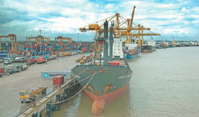
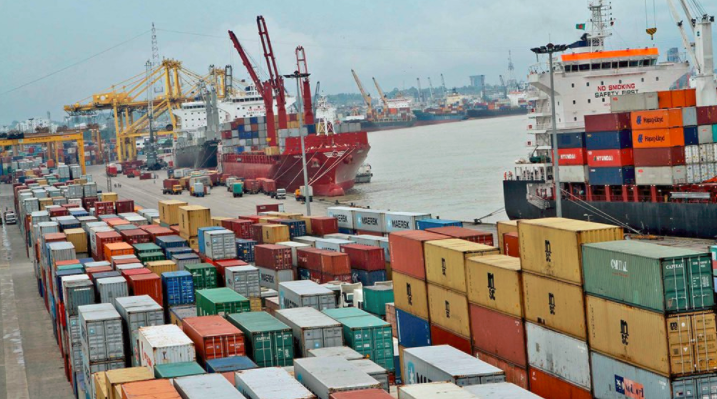
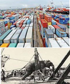
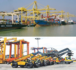
The Port of Chattogram is the principal port of Bangladesh. The port was established at its present location in 1887. By 1910, four jetties were constructed to handle 0.5 million MT of cargo annually. Since then the port has grown gradually to the present shape.
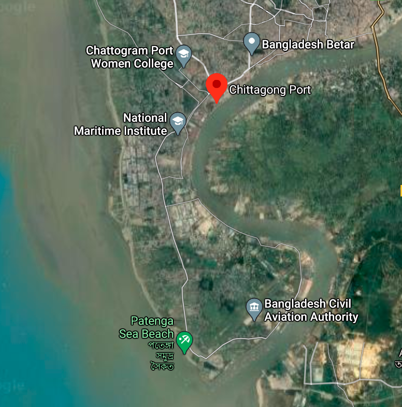
It is situated on the right bank of the river Karnafuli at a distance of about 9 nautical miles from the shoreline of the Bay of Bengal. Chattogram Port is considered the heart of the economy of Bangladesh. The geographic location of this port creates the opportunity for easy and cost-effective foreign trade to be carried out through with all South Asian countries as well as other Asian countries. Enough and low-cost labour is also readily available here. For these reasons, Chattogram Port holds much potential as a highly promising regional seaport. Consequently, cargo handling through Chattogram Port has not only rapidly increased but cargo type has also diversified. The Port is a regular member of Japan based International Ports and Harbours (IAPH).As a gateway of Bangladesh, Chattogram Port not only handles 92% of the country’s international trade but also generates about 35% annual revenue of the country on account of import tax, duties and VAT which confirms the significance of the port in the Government’s finance. About 80% export-import industries and 5-Export Processing Zone (out of 10 EPZ) are situated within Dhaka and Chattogram division and Dhaka- Chattogram corridor (transportation by rail, road & river) due to the Chattogram Port. This also helps to generate about 30% of the GDP. 100% imported Petroleum Oil and Lubricant (POL) of the country is transported through this port. Not only that, through this port 100% finished product are exported and 80% raw materials & accessories are imported. For Ready Made Garments (RMG) sector, which fetches about 76% of the country’s export earnings as hard currency.
Port website: http://cpa.gov.bd/
Key port information may also be found at: http://www.maritime-database.com
It is situated on the right bank of the river Karnafuli at a distance of about 9 nautical miles from the shoreline of the Bay of Bengal. River Karnafuli rising in the Lushai Hill falls in the Bay of Bengal after taking a winding course of 120 nautical miles through the districts of Chattogram Hill Tracts and Chattogram. Upper limits of the river water are formed by two straight lines, one drawn across the Karnafuli River in the North by joining 2 pillars located at Lat: 22024’33″N-Long: 91054’30E and Lat: 22024’56″N- Long: 91054’11″E and the other by joining the 2 pillars located at Lat: 22025’07″N- Long: 91053’18″E and Lat: 22025’07″N- Long: 91053’10″E. These limits include so much of the sea and of the River Karnafuli and the River Halda and the area that lie within 137.162 Metre, of high water mark at ordinary spring tide and the docks, wharves, quays, stages, jetties, piers, warehouse, sheds, railway line and yards within the limits of the bounded area and such other area outside it as included in the Schedule iii of the Chattogram Port Act. The seaward approach to the Port of Chattogram may considered to be northwards of the 10-fathom contour in latitude 22024′ North and longitude 9103″ East: The distance to the pilot ground from the south patches shoal being 46 nautical miles on the direct course.
Port Performance
Chattogram Port is the core hub of export and import of the country. The port has been performing better and better each year despite lots of limitations. It is now competing with the world rated ports in terms of all matrix. This port is now ranked at 64 in the Lloyd’s list of 100 container ports in the world, which was 70th, 71st, 76th and 87th in last 4 years.
Vessels of draught ranges from 8.50 m. to 9.20 m
Maximum permissible LOA of a vessel is 190 meters
|
Seasonal Constraints |
||
|
Occurs |
Time Frame |
|
|
Rainy Season |
Yes |
The weather in Bangladesh is largely governed by the monsoon. The prevailing wind directions are from South to South East during the months of April through September. After taking easterly direction for a while the wind turns to the northerly and north-easterly directions, the later prevail from November to January. During the months of February and March, winds turn via westerly direction back to the Southerly to South Easterly. In excess of 20 Knots/ Beaufort wind scale 5 prevails for 6 percent to time while those in excess of 30 Knots/Beaufort wind scale 7 persists for about 0.1 percent of the time during cyclones i.e. During the transition between monsoon and dry seasons in May, October, and November. The area of Payra port experienced four severe Cyclonic water surges during the last 44 years. In 1960 & 1963 speeds recorded were 125 Knots Max. In 1970 and 1991 speeds were recorded 138 Knots max. and 180 Knots max. respectively. |
|
Financial Year |
No. of Vessels |
|
2012-2013 |
2,136 |
|
2013-2014 |
2,294 |
|
2014-2015 |
2,566 |
|
2015-2016 |
2,875 |
|
2016-2017 |
3,092 |
|
2017-2018 |
3,664 |
|
2018-2019 |
1,882 (till Dec 2018) |
|
Financial Year |
Import (Tons) |
Export (Tons) |
Inland (Tons) |
ICD (Tons) |
Grand Total (Tons) |
Growth (%) |
|
2012-2013 |
38,312,028 |
5,059,640 |
6,087,947 |
457,559 |
49,917,174 |
3.95 |
|
2013-2014 |
41,960,170 |
5,338,377 |
5,833,786 |
445,218 |
53,577,551 |
7.33 |
|
2014-2015 |
48,941,406 |
5,839,986 |
6,469,673 |
474,800 |
61,725,865 |
15.21 |
|
2015-2016 |
58,324,786 |
5,971,634 |
6,366,607 |
493,360 |
71,156,387 |
15.28 |
|
2016-2017 |
66,464,285 |
6,709,759 |
6,330,639 |
477,836 |
79,982,519 |
12.40 |
|
2017-2018 |
78,050,447 |
6,997,465 |
7,429,082 |
446,234 |
92,923,228 |
16.18 |
|
2018-2019 |
82,939,731 |
6,846,406 |
7,761,749 |
515,245 |
98,240,655 |
5.72 |
Container Handling Statistics of CPA
|
Financial Year |
Import |
Export |
Total |
|||
|
TEUs |
MT |
TEUs |
MT |
TEUs |
MT |
|
|
2013-14 |
812,918 |
11,125,348 |
812,591 |
5,012,427 |
1,625,509 |
16,137,775 |
|
2014-15 |
940,827 |
13,132,923 |
926,115 |
5,535,446 |
1,867,062 |
18,668,369 |
|
2015-16 |
1,109,355 |
15,498,565 |
1,080,084 |
5,642,419 |
2,189,439 |
21,140,984 |
|
2016-17 |
1,211,874 |
17,084,610 |
1,207,607 |
6,395,923 |
2,419,481 |
23,480,533 |
|
2017-18 |
1,363,375 |
19,089,447 |
1,342,534 |
6,880,740 |
2,705,909 |
25,970,187 |
|
2018-19 (Jul-Dec 18) |
719,433 |
96,74,719 |
725,911 |
33,82,752 |
14,45,344 |
13,057,471 |
Discharge Rates and Terminal Handling Charges
|
Vessels chargeable |
Rate of port dues |
|---|---|
|
Sea-going vessels |
USD 0.241 per GRT |
|
Sea-going vessel engaged in lightering within port limits |
USD 0.150 per GRT |
|
Sea-going vessels not engaged in lightering have not left the port after 30 days from the date of entry |
USD 0.050 |
|
Sea-going vessel entering for taking fuel, stores and water, etc |
USD 0.08 |
|
Vessels working within port limits, excluding sea-going lighters |
Not exceeding 10 GRT: 25 BDT per vessel Between 10 – 100 GRT: 200 BDT Between 100 - 200 GRT: 500 BDT Exceeding 200 GRT: 3 BDT per GRT Barge/flat: 1.5 BDT per GRT Country boat/Shampan: 0.25 per GRT. |
Other Charges
|
Berth occupancy charges |
Per GRT per day |
USD 0.03 |
|
|---|---|---|---|
|
Mooring occupancy charge |
At Own anchor |
Per GRT per day |
USD 0.02 |
|
At mooring |
Per GRT per day |
USD 0.015 |
|
|
Sea-going ships |
200 to 1,000 GRT |
Per Tug per Movement |
USD 82.50 |
|
Over 1,000 to 5,000 GRT |
Do |
USD 277.50 |
|
|
Over 5,000 GRT |
Do |
USD 594 |
|
|
Water supply charge |
At Roosevelt jetty |
Per 1000 liters |
30BDT |
|
At Mongla (local) At Mongla (to Ships) |
Per 1000 liters Per 1000 liters |
60 BDT USD 10 |
|
|
At Hiron pont (local) |
Per 1000 liters |
700BDT |
|
|
At Hiron pint (to ship) |
Per 1000 liters |
USD 20 |
|
|
Jetty Crane Charge |
Use of Jetty crane |
Per crane per period of 8 hours |
USD 45 |
|
Use of British crane |
Do |
USD 33.75 |
|
|
Non-Use of Jetty Crane |
If cancelled within less than 6 hours of booked period |
Do |
USD 40 |
|
If cancelled previous to 6 hours of booked period |
Do |
USD 20 |
|
|
Holliday charge (working on jetty) |
Per ship per holiday |
USD 60 |
|
|
Night charge (working on jetty) |
Per ship per night |
USD 30 |
|
|
Security guard engaged on the sea-going vessel |
Per person, per 4 hours |
BDT 150 |
|
Shifting / Detention Fees
|
Services |
Basis of Charge |
Rate |
|---|---|---|
|
Fees for shifting vessels from one berth or mooring or swinging her to another |
Per movement |
USD 29.80 |
|
Fees for such shifting taking place in whole or part between 6:00 pm to 6:00 am |
Per movement |
USD 59.60 |
|
Detention fees for failure of a vessel in arriving or sailing from the port in time |
Per day |
USD 100 |
|
Pilot detention fee |
Per day |
USD 20 |
|
Berthing or unberthing at the time of arrival or sailing of the vessels |
Each occasion |
USD 88.50 |
|
Same at the time of shifting |
Each occasion |
USD 44.25 |
Port & Harbour Dues
|
Services |
Basis of Charge |
Rate |
|
|---|---|---|---|
|
River dues |
Domestic cargo |
Per 1000 kg |
33BDT |
|
Import cargo |
Do |
BDT 15.30 |
|
|
Landing charge / Handling charge |
Bagged cargo (wheat and rice) |
Per 1000kg |
BDT. 40 |
|
Other bagged cargo (cement, iron, steel, salt, sugar etc) |
Do |
BDT. 32 |
|
|
All other imports not exceeding 3MT |
Do |
BDT. 90 |
|
|
Wheeled or tracked equip. |
Do |
BDT 175 |
|
|
Garments, cloths, cotton, etc |
Do |
BDT. 16 |
|
|
Crude refined oil, palm oil, soyabean oil etc |
Do |
BDT. 50 |
|
|
Other import more than 20 MT |
Do |
BDT. 250 |
|
|
Weight bridge charge |
Per 1000 Kg |
2.5BDT |
|
|
Trans-shipment charge at the same wharf |
Per 1000 Kg |
150% of landing charge |
|
|
Terminal charge on river traffic |
Per 1000 Kg |
21.70BDT |
|
Container Handling Charges
|
Services |
Time |
Basis of charge |
Up to 20’ Container |
Above 20’ container |
|
|---|---|---|---|---|---|
|
Loading / Discharging |
FCL Container |
- |
Per container |
USD 43.40 |
USD 65.10 |
|
LCL Container |
- |
Do |
USD 130.00 |
USD 195.00 |
|
|
Empty Container |
- |
Do |
USD 22.10 |
USD 33.20 |
|
|
Container storage |
Loaded Container |
1-4 days free |
Per container |
- |
- |
|
1st 7 days after free time |
Do |
USD 6.00 |
USD 12.00 |
||
|
8th -20th days |
Do |
USD 12 |
USD 24 |
||
|
Thereafter up to delivery |
Do |
USD 240 |
USD 48 |
||
|
Empty Container |
1-7 daus days |
Per container |
USD 6.00 |
USD 12.00 |
|
|
8-20 days |
Do |
USD 1200 |
USD 24.00 |
||
|
21 days onwards/per day |
Do |
USD 24.00 |
USD 48.00 |
||
Reefer Container Service
| Particulars of Charges | Basis of Charge | Rates |
|---|---|---|
| Supply of electricity and connecting and disconnecting reefers, including monitoring |
Per container, per diem or part thereof |
USD 9.00 |
| Change of status |
Per container per change |
USD 10.00 |
River Dues (Containerized)
|
Particulars of Charges |
Basis of Charges |
Rates (Not Exceeding 21 ft.) |
Rates (Exceeding 21 ft.) |
|---|---|---|---|
|
FCL container and Contents |
|||
|
Import |
Per container |
BDT. 408.00 |
BDT. 816.00 |
|
Export |
Do |
BDT. 184.00 |
BDT. 368.00 |
|
LCL container and Contents |
|||
|
Import |
Per 1000 kg. or part thereof |
BDT. 34.10 |
- |
|
Export |
Do |
BDT. 15.30 |
- |
Lift on / Lift off Charges
|
Lift on / lift off charge, Loaded container |
per container |
BDT. 1000.00 |
BDT. 1500.00 |
|---|---|---|---|
|
Lift on / lift off charge, empty container |
-do- |
BDT. 375.00 |
BDT. 562.50 |
Shore handling containerised cargo
| Particulars of Charges | Basis of Charges | Rates |
|---|---|---|
| Stuffing / un-stuffing | Per 1000 kg. or part thereof of contents | BDT. 300.00 |
Berthing Specifications
| Specifications | NB | Bulk Min | Bulk Max | Conventional Min | Conventional Max |
|---|---|---|---|---|---|
| Berths |
31 |
2.2 m |
186 m |
2.2 m |
190 m |
| Anchorages | No limit | 8.5 m | 11.5 m |
8.5 m |
11.5 m |
| Draught at anchor | N/A | 8.5 m | 11.5 m |
8.5 m |
11.5 m |
| Draught at Berth | N/A | 8.55 m | 9.2 m |
8.55 m |
9.2 m |
| Length Over All | N/A | No limit | 186 m |
No limitations |
186 m |
| Beam (maximum) | N/A | No limit | No limitations if length is 186 m |
No limitations |
No limitations provided length is 186 m or less |
General Cargo Handling Equipment
|
1 |
Mobile Crane |
10-50 ton |
51 |
|---|---|---|---|
|
2 |
Forklift Truck |
10-20 ton |
15 |
|
3 |
Forklift Truck |
3-5 ton |
130 |
|
4 |
Industrial Tractor |
25 ton |
12 |
|
5 |
Heavy Trailer |
20-25 ton |
07 |
|
6 |
Light Trailer |
6 ton |
30 |
|
7 |
Share Crane |
2-3 ton |
31 |
Container Handling Facilities
|
Facility |
Capacity/Nos |
|
|---|---|---|
|
Holding Capacity (GCB+CCT+NCT+NCY) |
38,917 TEUs |
|
|
Yards |
22 Nos. |
|
|
Container Freight Stations at GCB |
5 Nos (45,064 Sq.m) |
|
|
Container Storage yard at GCB |
282,239 sq.m |
|
|
CFS at CCT |
13,671 sq.m |
|
|
Container Storage yard at CCT |
150,000 sq.m |
|
|
Container Storage yard at NCT |
220,000 sq.m |
|
|
Container Storage yard at NCY |
63,000 sq.m |
|
|
Railway Container Siding |
550 m |
|
|
Reefer Points (440 volts) |
900 points |
|
|
Standby Generator |
14 MW (2X7) |
|
|
Water Reservoir |
140,000 Gallons |
|
|
Fire Brigade |
1 Unit |
Container Handling Equipment
|
Equipment Type |
Capacity (MT) |
Qty |
|
|---|---|---|---|
|
Quay Gantry Crane |
40 |
14 |
|
|
Mobile Harbour Crane |
84 |
2 |
|
|
Rubber Tyred Gantry Crane |
44 |
21 |
|
|
Straddle Carrier (04 High) |
40 |
36 |
|
|
Reach Stacker (RS) |
45 |
15 |
|
|
Forklift Truck |
25-42 |
6 |
|
|
Forklift Truck |
7-16 |
19 |
|
|
Reach Stacker |
7 |
6 |
|
|
Container Mover |
50 |
6 |
|
|
Terminal Tractor |
50 |
43 |
|
|
Terminal Trailer |
50 |
55 |
Container Facilities
|
|
At a time |
Yearly |
|
|---|---|---|---|
|
Container |
6,000 (TEU) |
100000 (TEU) |
6,00,000 (TEU) |
|
Cargo |
60,000 (MT) |
2,00,00,000 (MT) |
4,00,00,000 (MT) |
|
Car |
2,000 |
20,000 |
40,000 |
Customs
Customs clearance process is also mainly paper based and appraisal and verification are done without standardized modern logistics support (container scanner). Procedural complexities, lack of transparency and timeliness in decision-making often caused lot of harassment and delay in the customs clearance process.
Since 2000, ASYCUDA has been introduced without the two main modules EDI and Risk Assessment Management. The customs clearance procedures for import still consist of 13 to 16 steps, a cumbersome, redundant, paper ledger and list-oriented process. In the absence of modern technology in controlling & appraising method, problems of trust arise among the regulatory and trade body.
Food Handling Arrangements
For offloading from ships and safe storage of food grains CPA has dedicated a silo jetty at North Patenga. There is a silo situated adjacent to the jetty. It is one of the biggest silos in Bangladesh with storage capacity of 100,000 mt. It deals with wheat only and is under the administrative control of the Ministry of Food of the Government of Bangladesh. The strategy for Chattogram silo is to use it predominantly for quick clearance of incoming mother vessels carrying imported wheat, for storage of a national buffer stock, to maintain quality of stored grain and quick dispatching to up-country destinations with maximum efficiency.
From an operational point of view, Chattogram silo can be divided into three sub-systems:
- Receiving
- Storage
- Despatching
Receiving Sub-system
This silo has the facilities to receive food grain (particularly wheat) only in bulk through gantry. The objective of the system is as follows:
- To start unloading as quickly as possible.
- To unload grain from carrier within minimum possible time.
- To record the weight of all incoming grain accurately.
- To ensure safe storage.
Storage Sub-system
The Chattogram silo having a capacity of 103,804 MT of bulk wheat, it has 88 round bins and 54-star bins. The capacity of each round bin is 1,000 MT and the star bin is 225 MT. The silo is provided with a dust control machine. Existing fumigation on pest control systems is provided via a liquid spray system and peeled dispenser system, though it is rarely used due to non-infestation of the grain. The objective of this sub-system is to keep the grain in good quality.
Despatching Sub-system
This silo has the facilities to dispatch food grain both in bulk and bagged form. In bulk it is mainly delivered by river coaster in Narayangonj Silo and Khulna Steel Silo and through hopper wagon in Ashugonj, Santaher and Narayangonj Silo. The bagged cargo is delivered mainly through railway covered wagon and through truck in almost all CSD and LSD in the country.
Specification of Chattogram Silo
|
Highest Capacity |
103,804 MT |
|
|---|---|---|
|
Diameter of Circular Bins |
27’-0’’ |
|
|
Height of Bins |
94’-0” |
|
|
No. of Star Bins |
54 (250 MT) |
|
|
No. of Circular Bins |
88 (1,000 MT) |
|
|
Size of head house floor |
34’ x 74’ |
|
|
Height of head house above finished grade |
174’ |
|
|
Height of head house above airport runway |
150’ |
|
|
Depth of head house board pit |
24’ |
|
|
Pneumatic travelling ship unloading unit |
3 (600 MT/hour) |
|
|
Pneumatic static ship |
1 (200 MT/hour) |
|
|
Receiving belt conveyor |
3 (200MT/hour each) |
|
|
Main Bucket elevator |
4 (200MT/hour each) |
|
|
Basement chain conveyor |
8 (200MT/hour each) |
|
|
Automatic hopper scale |
4 (Computerized) |
|
|
Truck scale (Weigh bridge) |
1 (capacity 40 MT) |
|
|
Distribution belt conveyor with tripper |
6 |
|
|
Chemical Protecting sprayer |
6 |
|
|
Sp. Fumigation bins |
2 |
|
|
Grain Drier |
1 |
|
|
Grain cleaner |
1 (25 MT per hour) |
|
|
Bagging scale |
6 (8 bags of 85 kg/ min) |
|
|
Temperature indication system |
1 |
|
|
Truck loading (bag) |
8 |
|
|
Rail loading (bunk) |
2 |
|
|
Jetty length- (a) Unloading / Loading (b) |
328 meters/42 meters |
|
|
Sub station |
3 units (each 1200 KVA) |
Cargo Storage Space (Break-bulk)
|
Protected Area |
Outside Protected Area |
||||
|---|---|---|---|---|---|
|
Transit Sheds (1-9) |
09 |
64364 Sq Mtrs |
Warehouses |
06 |
25179 Sq Mtrs |
|
Warehouses DFPO |
04 |
20712 Sq Mtrs |
Open Dumps |
- |
200,000 Sq Mtrs |
|
Car Sheds (P & F) |
02 |
8696 Sq Mtrs |
|
|
|
|
Open Dumps |
- |
90,000 Sq Mtrs |
|
|
|
|
Note: Food Dept for Grains, TSP complex, Cement Clinker and different Oil company have their own storage facilities adjacent to their own Jetties/premises. |
|||||
Description and Contacts of Key Companies
For information on Bangladesh Port of Chittagong contact details, please see the following link:
4.4 Bangladesh Port and Waterways Company Contact List
For information on Bangladesh Port of Chittagong additional information, please see the following document:
Bangladesh Port of Chittagong Additional Information
Bangladesh Chittagong Port Overview
Bangladesh Port of
Chittagong Port Security
Note: The information provided in the attached documents, which has been taken from the old DLCA, does not match the structure of the new LCA and is therefore provided separately.
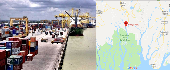
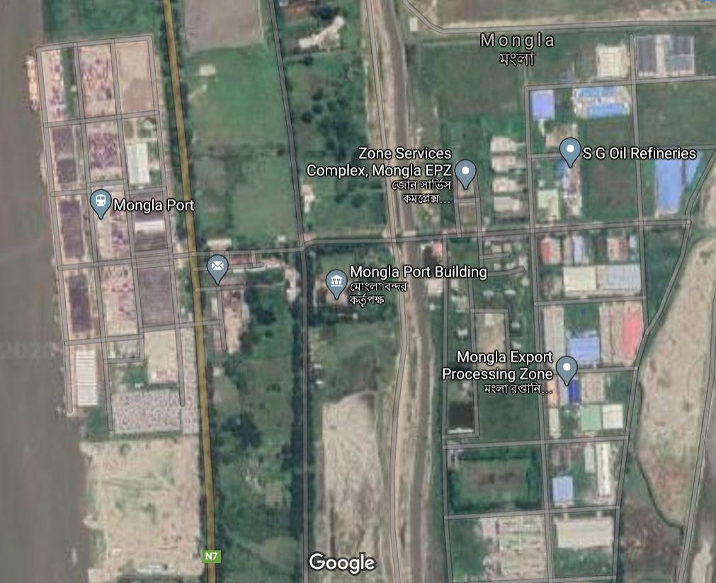
2.1.2 Bangladesh Port of Mongla
Port Overview
Mongla Port Provides facilities and services to the international shipping lines and other concerned agencies providing shore-based facilities like jetties, go downs, cargo handling equipment and maintaining adequate water depth in the channel as well as making provision for safe day and night shipping. Even if, in theory, there should be a ratio of 60 – 40 % between Chattogram and Mongla, the reality so far from that with Chattogram currently totalizing 92% of the country’s international trade.
Vision of MPA
- To Handle annually 1000 ships by 2021.
- To ensure international standard of service to the port users.
- To create congenial atmosphere for flourishing port base industries.
- To Modernize the port in the light of the global trade.
- To create job opportunities and to provide remarkable financial income to the national exchequer.
- To open new commercial windows for sustainable economic development.
Port website: Port of Mongla Website
|
Port Location and Contacts |
|
|---|---|
|
Country |
Bangladesh |
|
Province or District |
Khulna District |
|
Town or City (Closest location) with Distance (km) |
Name: Khulna km: 45 minutes from Kulna |
|
Port's Complete Name |
Port of Mongla |
|
Latitude |
22.48867 |
|
Longitude |
89.59283 |
|
Managing Company or Port Authority (If more than one operator, break down by area of operation) |
Mongla Port Authority |
|
Management Contact Person |
n/a |
|
Closest Airport and Frequent Airlines to / from International Destinations |
Airport Name: n/a Airlines: n/a |
Mongla Port Officer’s Contact List
|
Name & Address |
Designation and email |
Telephone and fax |
|---|---|---|
|
Name: Rear Admiral M Mozammel Haque, (G), NUP, ndc, psc, BN, |
Chairman Email: chairman@mpa.gov.bd |
Phone (office): 04662-75215 Fax: +041662-75224 |
|
Name: Yasmin Afsana |
Desig: Member (Finance) Email: mf@mpa.gov.bd |
Phone (off): 04662-7514 |
|
Name: Md. Altaf Hossain Khan |
Desig: Member (Engineering & Development) Email: med@mpa.gov.bd |
Phone (office): 04662-75333 Fax: 04662-75244 |
|
Name: Captain Mohammed Ali Chowdhury, (C), BCGM, ndc |
Desig: Member (Harbour & Marine) Email: chowali@yahoo.com |
Phone (office): 04662- 75222 Fax: 04662- 75224 |
|
Name: Md. Gias Uddin |
Designation: Director (Admin) Email: da@mpa.gov.bd |
Phone (office): +0466 2-75345 Fax: 04662- 75224 |
|
Name: Commander Sheikh Fakhar Uddin (C) BN |
Designation: Harbour Master Email: hm@mpa.gov.bd |
Phone (office): +04662-75221 |
|
Name: Lt Commander M ABDUL ALIM, (N), BN |
Desig: Chief Security Officer Email: cso@mpa.gov.bd |
Phone (office): +04662-75232 |
|
Name: Mr. Ohiuddin Chowdhury |
Designation: Secretary Email: oc2225@gmail.com |
Phone (office): +04662-75275 |
|
Name: Md. Zahirul Huq |
Designation: Chief Planning Email: cp@mpa.gov.bd |
Phone (office): +04662-75218 |
|
Name: Md. Mostafa Kamal |
Designation: Director (Traffic) Email: kamal6498@yahoo.com |
Phone (office): +04662-75363 |
|
Name: Md. Faruqul Islam |
Desig: Chief Hydrographer Email: faruqulchmpa@gmail.com |
Phone (office): +04662-75312 |
Port Facilities and Infrastructure
|
Total Berths |
Quantity |
Length (m) |
Draft (m) |
|---|---|---|---|
|
General Cargo/ Container Berths |
5 |
max 225 m |
4.5 – 5 m |
|
River Mooring Buoys |
7 |
max 225 m |
3 – 8 m |
|
Anchorage Berths |
14 |
max 225 m |
4.7 – 9 m. |
|
Mongla Cement Factory Jetty (Private) |
1 |
max: 225 m |
6.1m |
|
Meghna Cement Factory Jetty (Private) |
1 |
max: 225 m |
6.5 m |
|
Klean Heat Gaz Factory (Private) |
1 |
max 225 m |
6.0m |
|
Summit United LPG Jetty |
1 |
max 225 m |
1.8m |
|
Summit United Petroleum Jetty |
1 |
max 225 m |
Not available |
|
Dubai-Bangladesh Cement factory Jetty |
1 |
max 225 m |
Not available |
|
Holcim Cement Factory Jetty |
1 |
max 225 m |
Not available |
|
Vessel Concrete Jetty |
1 |
max 225 m |
Not available |
|
Pontoon Berth (for Fresh Water |
1 |
max 225 m |
Not available |
|
Pontoon berth (Inland vessels & Ferry) |
1 |
max 225 m |
Not available |
|
Berthing Tugs & Mooring Boats |
3 |
|
|
|
Pilot Boats |
3 |
||
|
Water Barges (Dumb) |
4 * 500 MT |
||
Port Facilities at a Glance
- The port is surrounded as well as well protected by the mangrove forest Sundarbans and free from all types of congestion of ships and cargo.
- River and road transport facilities available comparatively at lower cost from Mongla port to all over the remote places of the country.
- Constraint free large channel available for anchorage and loading/unloading facilities on both sides for 33 ships at a time.
- Due to construction of Khanjahan Ali as well as Lalonshah bridge, good transport connection system has been developed from Mongla Port to all the hinterland of North Bengal.
- Unique opportunity for Dhaka-Mongla-Dhaka transportation only within 5 hours by Dhaka-Maowa Road, in spite of a ferry service on the way.
- As there is no by-crossing, the goods can be transported easily without any constraint by inland coaster/barge from Mongla port.
- Up to 225-meter-long ship can enter into the port for discharging cargo.
- No constraints in berth and less turn-around time.
- In compare with Chattogram Port, the Landing charge, Shipping charge and River dues are lower in Mongla port.
- 15 days free time available in case of handling empty container (Import).
- The port is open for 24 hours.
- Infrastructural facilities available for storage of both specialized and General cargo.
- Handling & parking facilities of motor vehicles available.
Port Performance and Capacity
Port performance in last 3 Years
| Performance Type | Export/ Import | FY 2016 - 17 | FY 2017 - 18 | FY 2018 - 19 |
|---|---|---|---|---|
| Vessel Handling | - | 623 | 784 | 961 |
| Car Handling | - | 15,907 | 17,295 | 19,200 |
| Container Handling (TEU's) | Export | 12,805 | 21,229 | 29,330 |
| Import | 14,147 | 21,760 | 28,408 | |
| Container Handling (Boxes) | Export | 8,094 | 14,032 | 20,290 |
| Import | 9,146 | 14,341 | 19,426 | |
| Cargo (MT) | Export | 85,622 | 147,151 | 135,131 |
| Import | 7,428,105 | 9,568,899 | 11,179,878 | |
| Food Stuff (MT) | Export | 31,452 | 33,278 | 35,011 |
| Import | 441,359 | 896,324 | 131,379 | |
| Total Income (Million BDT) | - | 2297.0 | 2664.2 | - |
Storage Facilities
| Name | Quantity | Length/ Area | Capacity |
|---|---|---|---|
| Mongla Port Area | |||
| Transit Shed | 4 Nos. (5-8) | 19,628 Sq Mtr | 17,932 MT (Total Capacity) |
| Warehouse A&B | 2 Nos. | 19,630 Sq Mtr | 15,326 MT (Total Capacity) |
| Container yard | 4 Nos. | 45,530 Sq Mtr | - |
| Open dumps | - | 300,000 Sq Mtr | - |
| Freezer plug points | 160 | - | - |
| Car parking yard | 2 | For 2,000 cars | - |
| Khulna Roosevelt Jetty Area | |||
| Transit shades | 1 & 2 | 1,125 Sq Mtr | - |
| Open dumps | - | 25,000 Sq Mtr | - |
Cargo Handling Equipment
| Name of Equipment | Number of equipment | Capacity (M/Ton) |
|---|---|---|
| Mobile Crane | 6 | 2x30 MT, 1x24 MT, 1x25 MT & 2x19 MT |
| Forklift various capacity | 36 | 2-5 MT |
| Straddle carrier | 6 | - |
| Reach stacker | 2 | - |
| Jetty dock crane | 2 | - |
| Terminal Tractors | 6 | - |
| Empty container handler | 3 | - |
| Harbour crane | 1 | 84 MT but 32 MT Extended Boom |
| Vessel & craft (various types) | 32 | - |
| Total | 62 | - |
Container Handling Capacity
|
Item |
Capability |
Projected Capacity by 2025 |
|
|---|---|---|---|
| At a time | Yearly | ||
| Container | 6,000 (TEU) | 100000 (TEU) | 6,00,000 (TEU) |
| Cargo | 60,000 (MT) | 2,00,00,000 (MT) | 4,00,00,000 (MT) |
| Car | 2,000 | 20,000 | 40,000 |
Clearing Agents / Stevedore
There are almost 600 clearance agents and around 100 stevedore companies. They are appointed on a yearly base, after a call for tender process. List of stevedors who have renewed their licence from Mongla Port Authority for the current year is as follows.
Port Stevedores list
| Sl | Name of the Organization | Address | Contact Number |
|---|---|---|---|
| 1 | M/S Sheikh Abdus Salam & Co. | Madrasa Road Mongla, Bagerhat | 01711343054 |
| 2 | M/S A Haq Choudhury & Sons | 2, P C Roy Road, Khulna | 01711761747 |
| 3 | M/S Khalid Brothers | 67 Khan A Sabur Road, Khulna | 01711335860 |
| 4 | M/S Nuru & Sons Co | Shromo Kollan Road, Mongla, Bagerhat | 01713181224 |
| 5 | M/S Gofur Brothers & Co | Rabeya Complex, 116/2, Islampur Road, Shantidham More, Khulna | 01711280124 |
| 6 | M/S Khulna Traders Ltd. | 6, Shamsur Rahman Road, Khulna | 01711218888 |
| 7 | M/S Pator Para Traders | Port Using Building 6th Floor, 1st Flat, Mongla | 01764527749 |
| 8 | M/S Green Enterprise | 53 Shromo Kollan Road, Mongla, Bagerhat | 01711761668 |
| 9 | M/S Lucky Trading Corporations | 309, Khanjahan Ali Road, Khulna | 01711896661 |
| 10 | M/S M. A. Hashem & Sons | 6/1, Madrasa Road, Mongla, Bagerhat | 01711400797 |
| 11 | M/S Jahir Traders | Chalna House, 3 P C Roy Road, Khulna | 01711380569 |
| 12 | M/S Obiroto Agencies Ltd. | 8, Baitun Nur Shopping Complex | 01716781461 |
| 13 | M/S K M Shipping Lines Ltd. | 11, KDA Avenue, Nowshin Tower (5th floor), Khulna | 01711296685 |
| 14 | M/S United Trading Co. | Rabeya Complex, 116/2 Islampur Road, Khulna | 01711280124 |
| 15 | M/S The Linkers International (Pvt) Ltd. | 101, Haji Mohsin Road, Khulna | 01711299179 |
| 16 | M/S Khulna Union Enterprise Ltd. | 205/8 Sonadanga R/A, Khulna | 01711524649 |
| 17 | M/S Moni Traders (Pvt.) Ltd. | 13 Shrom Kollyan Road, Mongla | 01713124709 |
| 18 | M/S Mecca Medina Enterprise | Shrom Kollyan Road, Mongla | 01725378430 |
| 19 | M/S Siraj Shipping | Port Powerhouse Road, Mongla | 0711482906 |
| 20 | M/S Ahommed & Co. | 17, Beni Babu Road, Khulna | 01712608285 |
| 21 | M/S Rahman Enterprise | Port Building 6th floor, 3rd flat, Mongla | Not Provided |
| 22 | M/S Khulna Agency | 269/2, Khanjahan Ali Road, Khulna | 01715368262 |
| 23 | M/S Amin Enterprise | 6, Lower Jeshore Road, Khulna | 01711297825 |
| 24 | M/S Morelgonj Traders | 43/E, road 29, Nirala Residential Area, Khulna | 01711481774 |
| 25 | M/S M A Baten | 5, PC Roy Road, Khulna | 01711323620 |
| 26 | M/S Aroj Ali & Co | 92, Khan A Sabur Road, Khulna | 01711131606 |
| 27 | M/S S M Akbor Hosen | 72, Sir Ikbal Road, Khulna | 01711805124 |
| 28 | M/S T Haq & Co. Ltd | Monowara Mansion, room 1, 15, Dr. Moshiur Rahamn Road, Khulna | 01813751155 |
| 29 | M/S M Rahman & Brothers | 63/4, Sonadanga R/A, Khulna | 01711029460 |
| 30 | M/S Sonar Bangla Traders | 40, Station Road, Khulna | 01713400138 |
| 31 | M/S A Rajjak Dovash & Sons Ltd. | Yakub Ali Building, Mongla | 01711263316 |
| 32 | M/S Associated Traders & Meriners Ltd. | Khalil Chamber, 35, KDA Avenue, Khulna | 01730007825 |
| 33 | M/S Jebun Associates Ltd. | Sheikh Abdul High Sarak, Mongla | 01819685568 |
Port Essential Information
|
Port management |
The port is under the administrative control of the Ministry of Shipping. The Chairman is the Chief Executive of the Port. Mongla Port Authority is managed by a board which consists of Chairman and three other members. Board formulates policies concerning operation, administration, finance and development of the port. Other 11 departments are there to assist in performing port operation. |
|---|---|
|
Port Limit |
· To the North: A line drawn due East West from a point in position Lat. 220 38.00’ N. Long 89020.00 E. to a point in position lat. 22038.00 N. long 89040.00’ E. · To the South: A line drawn due East West from a point in position Lat. 21027.00’N. Long 89020.00 E. to a point in position lat. 21027.00 N. long 89040.00’ E. · To the East: A line joining the point in position Lat. 21027.00 N. Long 89040.00’ E. with the point in position Lat. 22038.00Ñ N. long 89040.00’ E. · To the West: A line joining the point in position Lat. 22038.00 N. Long 89020.00’ E. with the point in position lat. 21027.00 N. long 89020.00’ E. |
|
Navigational Information |
• Vessels of 6.0 m. to 8.5 m. draught can take berth in anchorage, mooring buoys and jetties. • Maximum LOA of vessels: 200 meters • Tidal range: between 1.2 and 3.5 meter • Pilotage : Compulsory • Night navigation is permissible for outward and inward movement of ships up to 140m. LOA and 6.0 m draught. • 51 Lighted buoys are available at the Channel. “Conical shape" buoys are on starboard side and "can shape" buoys on the port side. |
|
Hydrographic Information |
The tides are important for navigation as determines the possibility of crossing the shallow outer bar at the entrance. The tides are semi diurnal with prominent diurnal effect. The approx. tidal range is between 1.2 m. to 3.5 m. all over the channel. |
|
Anchorage |
Mongla port consists of shore-based facilities and a sheltered anchorage in the Pussur River. Depth of water available at the anchorage is max. 8.0 M. of LLWD. Distance from Mongla fairway buoy to Mongla port Jetty is 65 Nautical miles. |
|
Restrictions |
Entrance to the Pussur river is about 2 miles wide at the mouth and has a bar about 5 nautical miles from the Fairway Buoy where minimum depth is 6 m. |
|
Maximum Size of Ships |
Ships drawing up to 7 M. can cross the bar in all seasons. During S.W Monsoons vessels up to 8.0 M. can cross the outer bar in spring tide. |
|
Telecommunication |
At present coast station Khulna Radio of telegraph and Telephone Dept. maintain 24 hrs. W/T watch 0n 500 KHz (call sign S3E). In addition to the T & T system, the port has harbor control station (call sign S3H) at Mongla and Hiron point pilot station (call sign S3K) to maintain 24 hrs. W/T watch 0n 500 KHz. The station at Hiron Point guides incoming and outgoing vessels from fairway to pilot grounds and vice versa and also remains in touch with Khulna Radio, S 3 E, Mongla S 3 H and ships anchored at Hiron point for movement of pilots and Mooring of vessels. |
|
Arrival Advice |
Incoming ships must be present at Mongla Fairway Buoy at least 3 hours before H.W. at Hiron point, to enter on a day. The master should send the following information to Port Control via Khulna Radio call sign S3E and Hiron point pilot station call sign S3K 24 hrs. prior to arrival at Mongla Fairway buoy: 1.ETA Mongla Fairway Buoy 2. Fresh water draught 3. Speed available 4. Length of vessel 5. Gross tonnage of vessel 6. Flag of vessel 7. Fresh water requirements 8. Local Agent. |
|
Tugs |
3 powerful Tugs are available to attend emergency & also for berthing at jetties, Mooring buoys and Anchorages. |
|
Berthing |
8 single swinging Moorings, 21 Anchor berths & 5 Jetties are available. |
|
Density |
The density of water at the Outer Bar varies from 1005 to 1025 and at Mongla from 1002 to 1015. |
|
Fresh Water |
Available by Barges |
|
Fuel |
Fuel oil can be arranged in Ltd quantities if 48 hours advance notice is given to the respective owner/declaring Shipping Agents. |
|
Fire Precautions |
Fire Fighting Tug is available. |
|
Repairs |
Minor repairs can be arranged through Khulna shipyard & other private workshops. |
|
Surveyors |
Lloyds / NKK, P & l Club and private surveyors are available at Khulna. |
|
Deck Watchman |
On receipt of orders from the Master the Steamer agents will arrange to supply necessary watchmen day and night. |
|
Cargo Gear |
Goods are loaded and unloaded by the ship's gear. Handling equipment and crane available at the Port Jetty. |
|
Repatriation |
Local shipping agents are responsible for arranging repatriation of the crew. |
|
Police/Ambulance/Fire |
Police Telephone number 04658-222 and for other purposes Harbor Control 004658-309 and Harbor Master's Telephone No. 04031-221 (off) & 041-760625 (Res) is available. |
Miscellaneous Port Information (Berthing equipment specifications)
|
Berthing facilities |
2 ships at the jetty, 5 ships at mooring buoy and 7 ships at anchorage and including private jetties total 14 ships can take berth at a time. Besides, there is wide scope of berthing of more ships in the anchorage. |
|---|---|
|
Jetty/Warehouse/Yard facilities |
5 Jetties (length 182.92 meter each), 4 transit sheds (4907 Sq. m. each & total capacity in average 17932 MT), 2 warehouses (9815 Sq. m.) each & total capacity in avr.15326 MT),120 reefer plug points and 3 container yards (35752 TEUS at one stack). |
|
Facilities in the Channel |
Channel draft is 6.0 to 8.5 meter. For safe guidance of ship in the channel there are 21 lighted buoys (inner channel-3 buoys, outer anchorage- 16 buoys and fairway buoy-1) and 1 Beacon (at Hironpoint). Max. length of 200-meter ships can cross the Pussur channel. |
|
Electricity Facilities |
For constant supply of electricity there are 6 sub-stations and 5 power generating stations. Moreover, special facilities are provided for reefer container from own generator of MPA |
|
Vessels & Crafts |
3 Tugboats, 01 Firefighting tug, 2 Pilot launch, 4 dispatch launch, 3 Survey launch, 4 Mooring boats, 1 Buoy Tender Vessel, 3 Self-propelled watercrafts, 2 Inspection launch, 1 Oil storage vessel, 2 ferry launch- total 26 vessels and crafts are ready for smooth functioning of Port. |
|
One Stop Service |
One Stop service is being operational in the Jetty area. In this, all departments who are directly involved in the Operation are being in one room. Therefore, the port users need not to move from one department to the other department in order to get their job done. This has created a very user-friendly environment and the activities have become easier and speedy. |
Pilotage to the Port
The Pilotage ground extends from the fairway buoy, approximately at position Lat. 21026.9'N Long. 89034.4'E, to the northern limit of the port (Up to a line drawn between Lat. 22038.00' N Long. 89020.00' E and Lat. 22038.00' N Long. 89040.00' E).
The sharply defined "Swatch of No Ground" - the northern tip of which almost touching the pilotage ground, a nature’s boon to the mariners is approaching this port. A fairly accurate position of vessels can be obtained by watching the Echo-Sounder indicating entry of vessel into the "Swatch of No ground". It is usual for the navigators making approaches from Kolkata and Chattogram to proceed between 20- and 30-meter contour which is quite well defined and converge on the northern most tip of the “Swatch of No Ground ".
The lighted Buoy painted “MONGLA FAIRWAY" and fitted with a radar reflector flashing white light every 10 seconds, makes the approach to the Pilotage ground reasonably easy and safe.
From the ' fairway buoy' to pilotage ground (Near Hiron Point) the channel is marked by 9 pairs of lighted buoys with radar reflectors. Masters of vessels before approaching the pilotage ground should await instructions from the Hiron point pilot stations. Mariners are cautioned that they may have to take appropriate corrective measures as the vessels are likely to set towards North-West during flood tide.
Ship approaching Mongla Port will send their ETA and draft to their respective agents and to PORT KHULNA vis Khulna Radio (Call sign S3E) at least 24 hrs. before their actual time of arrival at the Fairway Buoy. On receipt of the ETA directly from the ship the pilot is detailed in order of priority of arrivals. Further instructions are issued by the pilot himself on VHF. On or before arrival at the Fairway Buoy, the Master is to contact the Hiron Point Pilot Station on W/T (Call sign S3K) or on channel 16 on VHF for bar crossing instructions. It must be emphasized that the instructions so received should be repeated by the ship receiving such messages. The banks of the river are stable and have continuous belt of forest with small creeks at places throughout the passage up to the Mongla Harbor area. The controlling bar at the entrance of Pussur River has a minimum datum depth of 6.0 M. This sets limit to the draft of ships entering and leaving Mongla Port.
Tides and semi diurnal with spring rise between max. 2.80 M. in winter to max. 3.35 M. in Monsoon. Tidal stations at Hiron Point, Joymonirgol and Mongla are maintained for observation and record of daily tides. Unlike other riverine ports of the Bay of Bengal there are no incidents of bore tides or freshets. During Monsoon the Hinterland Rivers are in spate and current may attain strength up to 6 knots. The bottom is mainly of mud and fine sand.
The channel is marked by buoys at various points conical shapes to be passed on the starboard hand and can shapes on the port hand when entering with the mainstream of flood. Weather is mainly tropical with very mild winter with minimum temperature of 8'C and humidity 95% and during south westerly monsoon from June to August causing rainfall of average 200 cm. Tropical revolving storm is formed in the Bay of Bengal during the preceding (April-May) and succeeding (Sept-Oct.) two months of Monsoon. The intensity of the storm is lost on reaching the port after crossing the coast and the Sundarbans. A common weather feature is the Norwester in the months of March and April which are typical thunderstorms of very short duration usually occurring at dusk with squally winds up to 40kts.
Port Dues and Charges
Port Dues and Charges (as of January 2020)
|
Vessels chargeable |
Rate of port dues |
|---|---|
|
Sea-going vessels |
0.241 $ per GRT |
|
Sea-going vessel engaged in lightering within port limits |
0.150 per GRT |
|
Sea-going vessels not engaged in lightering have not left the port after 30 days from the date of entry |
0.050 $ |
|
Sea-going vessel entering for taking fuel, stores and water, etc |
0.08$ |
|
Vessels working within port limits, excluding sea-going lighters |
Not exceeding 10 GRT: 25 BDT per vessel Between 10 – 100 GRT: 200 BDT Between 100 - 200 GRT: 500 BDT Exceeding 200 GRT: 3 BDT per GRT Barge/flat: 1.5 BDT per GRT Country boat/Shampan: 0.25 per GRT. |
Other Charges
|
Berth occupancy charges |
Per GRT per day |
0.03$ |
|
|---|---|---|---|
|
Mooring occupancy charge |
At Own anchor |
Per GRT per day |
0.02$ |
|
At mooring |
Per GRT per day |
0.015$ |
|
|
Sea-going ships |
200 to 1,000 GRT |
Per Tug per Movement |
82.50$ |
|
Over 1,000 to 5,000 GRT |
do |
277.50$ |
|
|
Over 5,000 GRT |
do |
594$ |
|
|
Water supply charge |
At Roosevelt jetty |
Per 1000 ltr |
30BDT |
|
At Mongla (local) At Mongla (to Ships) |
Per 1000 ltr Per 1000 ltr |
60BDT 10$ |
|
|
At Hiron pont (local) |
Per 1000 ltr |
700BDT |
|
|
At Hiron pint (to ship) |
Per 1000 ltr |
20$ |
|
|
Jetty Crane Charge |
Use of Jetty crane |
Per crane per period of 8 hours |
45$ |
|
Use of British crane |
Do |
33.75$ |
|
|
Non-Use of Jetty Crane |
If cancelled within less than 6 hours of booked period |
Do |
40$ |
|
If cancelled previous to 6 hours of booked period |
Do |
20$ |
|
|
Holliday charge (working on jetty) |
Per ship per holyday |
60$ |
|
|
Night charge (working on jetty) |
Per ship per night |
30$ |
|
|
Security guard engaged on the sea-going vessel |
Per person, per 4 hours |
BDT 150 |
|
Shifting / Detention Fees
|
Services |
Basis of Charge |
Rate |
|---|---|---|
|
Fees for shifting vessels from one berth or mooring or swinging her to another |
Per movement |
29.80$ |
|
Fees for such shifting taking place in whole or part between 6:00 pm to 6:00 am |
Per movement |
59.60$ |
|
Detention fees for failure of a vessel in arriving or sailing from the port in time |
Per day |
100$ |
|
Pilot detention fee |
Per day |
20$ |
|
Berthing or unberthing at the time of arrival or sailing of the vessels |
Each occasion |
88.50$ |
|
Same at the time of shifting |
Each occasion |
44.25$ |
Port & Harbour Dues
|
Services |
Basis of Charge |
Rate |
|
|---|---|---|---|
|
River dues |
Domestic cargo |
Per 1000 kg |
33BDT |
|
Import cargo |
Do |
BDT 15.30 |
|
|
Landing charge / Handling charge |
Bagged cargo (wheat and rice) |
Per 1000kg |
BDT. 40 |
|
Other bagged cargo (cement, iron, steel, salt, sugar etc) |
Do |
BDT. 32 |
|
|
All other imports not exceeding 3MT |
Do |
BDT. 90 |
|
|
Wheeled or tracked equip. |
Do |
BDT 175 |
|
|
Garments, cloths, cotton, etc |
Do |
BDT. 16 |
|
|
Crude refined oil, palm oil, soyabean oil etc |
Do |
BDT. 50 |
|
|
Other import more than 20 MT |
Do |
BDT. 250 |
|
|
Weight bridge charge |
Per 1000 Kg |
2.5BDT |
|
|
Trans-shipment charge At the same wharf |
Per 1000 Kg |
150% of landing charge |
|
|
Terminal charge on river traffic |
Per 1000 Kg |
21.70BDT |
|
Container Handling Charges
|
Services |
Time |
Basis of charge |
Upto 20’ Container |
Above 20’ container |
|
|---|---|---|---|---|---|
|
Loading / Discharging |
FCL Container |
|
Per container |
43.40$ |
65.10$ |
|
LCL Container |
|
Do |
130.00$ |
195.00$ |
|
|
Empty Container |
|
Do |
22.10$ |
33.20$ |
|
|
Container storage) |
Loaded Container |
1st 10 days |
Per container |
3.00$ |
6.00$ |
|
Thereafter |
Do |
8.00$ |
16.00$ |
||
|
Empty Container |
First 7 days |
Per container |
1.5$ |
3.00$ |
|
|
Thereafter |
Do |
3.00$ |
6.00$ |
||
|
Over height Container (Loaded) |
1st 10 days |
Per container |
4.00$ |
8.00$ |
|
|
Thereafter |
Do |
8.00$ |
16.00$ |
||
|
Over height Container (Empty |
1st 7 days |
Per container |
3.00$ |
6.00$ |
|
|
Thereafter |
Do |
5.00$ |
10.00$ |
||
|
Reefer container Charge |
Pre-trip inspection |
Per Container |
2.00$ |
|
|
|
Supply of electricity |
Per Container per diem |
8.00$ |
|||
|
Monitoring service |
Per Container |
4.00$ |
|||
|
River dues on container and Containerised Cargo |
FCL Container and content |
Import |
Per container |
408.00BDT |
816.00BDT |
|
Export |
Do |
184.00BDT |
368.00BDT |
||
|
LCLContainer and content |
Import |
Per 1000 kg |
34.10BDT |
||
|
Export |
Do |
15.30BDT |
|||
|
Empty Container |
Import |
Per container |
102.00BDT |
204.00BDT |
|
|
Export |
Do |
102.00BDT |
204.00BDT |
||
|
Stuffing and unstuffing Charges |
Stuffing |
Per 1000kg |
75.00BDT |
||
|
Unstuffing |
Do |
92.00BDT |
|||
|
Transhipment charge |
Per container |
150% of the Loading or Discharging Charge. |
|||
Due and Charges on Goods
|
Rent Charge (Wharf rent) for import cargo (covered storage) |
Basis of charge |
0 to 7 days |
8 to 14 days |
For each additional day up to 22 days |
|---|---|---|---|---|
|
Bagged cargo |
Per 1000kg |
6.50BDT |
15.00BDT |
25.00BDT |
|
Iron and steal |
Do |
6.00BDT |
15.00BDT |
25.00BDT |
|
Wheeled or tracked vehicles |
Do |
28.35BDT |
80.71BDT |
129.29BDT |
|
All other imports |
Do |
10.00BDT |
20.00BDT |
25.00BDT |
Space Rent Charge
|
Service |
Basis of charge |
rates |
|
|---|---|---|---|
|
Cargo inside the protected area |
First month |
Per sq² / meter |
46.88BDT |
|
Second month |
56.25BDT |
||
|
Subsequent months |
70.31BDT |
||
|
Cargo outside protected area |
Per sq² / meter |
40.00BDT |
|
|
Storage of gears equip and other |
Do |
40.00BDT |
|
|
International transit |
Do |
30.00BDT |
|
Goods Carrying Charges on board water burges
|
Khulna to Mongla |
Per MT |
100BDT |
|
Khulna to Hironpoint |
BDT 200 |
|
|
Mongla to Hironpoint |
BDT 150 |
Food Handling Arrangements
Mongla Port is not very well equipped for the bulk grain handling. There are no vacuators, silo facilities and bagging machines at the port. No silo terminal at port level. But a small silo of 500 MT exists in Khulna and recently big modern silo is at Joymonir goal has been established.
Mongla Port Silo
In order to have Safe Storage Facilities of Food grains a modern Silo has been built at Joymonirgol, 17 km south of Mongla Port. The silo has a storage capacity of 50,000 MT in 30 different bins. The area is fully equipped with an Independent Jetty along with all types of handling facilities. So Mongla port is now fully ready to accept any quantity of imported food grains.
Reefer Cargo Arrangements
Reefer cargo particularly export of frozen shrimps is predominant through this port. In the container yard no. 1 & 2 there are 160 plug points to connect reefer containers. Electricity is being supplied from electric substations to the reefer container. For constant and uninterrupted power supply MPA has its own generators which are capable to supply power to 40 containers. Provision of 110 volt power supply for reefer container is also available in the container yard.
Port Development Trend
In Bangladesh, the industries are in and around Dhaka-Chattogram. The business community of Dhaka and its surrounding areas is less interested to import and export their cargo through Mongla Port because of lack of fair roads and bridges connection. The present government has given emphasis for the development of Mongla Port and pushes the construction of the Padma Bridge at Mawa point. When Padma bridge will be operational, the distance from Dhaka to Mongla will be 170 Km. So, the business community of Dhaka and its surrounding areas will be more interested to use Mongla Port for importing & exporting cargos as the transportation distance from Dhaka to Mongla will be shorter than Dhaka to Chattogram.
At present, Jute & jute goods, frozen cargo and other general cargo are exported from Mongla port. Moreover, import of heavy machinery & equipment, fertilizer, food grain, sugar, motor vehicles, raw materials of industry etc. through Mongla Port will increase. As a matter of consequence, the act of establishing different types of new industries in the south-western part of the country, scope of huge employment, expansion of trade & business and overall activities of Mongla Port will increase and develop rapidly.
Ongoing Development Project
|
Sl |
Project name; Estimated cost; Implementation period |
|---|---|
|
1. |
Capital dredging of cattle channels from Mongla port to Rampal power station. Estimated expenditure: BDT. 16650.00 lakh. Implementation: 2016 – 17 to 2018 – 19 |
|
2. |
The development of existing infrastructure at the Mongla Port Authority's Roosevelt Jetty. Estimated expenditure: BDT. 2360.00 lakh. Implementation: July 2017 to December 2019 |
|
3. |
Inauguration of the Vessel Traffic Management and Information System (VTMIS). Estimated expenditure: BDT. 4890.78 lakh. Implementation: 2017-18 to 2018-19 |
|
4. |
Dredging at the Mongla Port Channel. Estimated expenditure: BDT. 71250.00 lakh. Implementation: July 2017 to December 2019 |
|
5. |
Tug Boat Collection for Mongla port. Probable expense: BDT 4929.00 lakh. Implementation: January 2018 to December, 2018 |
|
6. |
Surface water Treatment Plant set up for Mongla port. Probable expense: BDT 2472.50 lakh. Implementation: 2018 - 19 to 2019 - 20 |
|
7. |
Dredging in the food silo area of the Harbor channel in Mongla port Probable expense: BDT 3638.85 lakh Implementation: 2018 - 19 to 2019-20 |
|
8. |
Strategic master plan for Mongla Port. Estimated expenditure: BDT. 530.00 lakh Implementation: SEPA: 2016 to June 2019 |
|
9. |
Essential Equipment collection for Mongla port. Probable expense: BDT 43352.00 lakh Implementation: July 2018 to June 2021 |
|
10. |
Under PPP: Construction of 2 incomplete jetty of Mongla port Estimated expenditure: BDT. 41200.00 lakh. Implementation: 2016-17 to 2020 - 21 |
Projects in Approval Process
|
1. |
Expansion and Modernization of the facility of Mongla Port: 1. Container terminal construction of Mongla port. 2. Container delivery yard construction at Mongla Port 3. Bobbing yard construction. 4. Multistoried Car Yard construction 5. of cattle on the channel of the Sinking rake removal 6. The main road of Mongla Port (Six Lane and bypass road) 7. River protection works at the Jetty area. Probable expense: BDT 447744.97 lakh. Implementation period: 2022 - 23 |
|---|---|
|
2. |
Collection of Trailing Suction Hopper Dredger. Probable expense: BDT 32000.00 lakh. Implementation: 2017 – 18 to 2019 - 20 |
|
3. |
Upgradation of Mongla Port Probable expense: BDT 60146.90 lakh. Implementation: from 2018 – 19 to 2022 – 23 |
|
4. |
Modern waste management at Mongla Port. Probable expense: BDT 32221.00 lakh Implementation: July 2018 to June, 2021 |
|
5. |
Collection of 2 Oil recovery vessels, Oil boom and accessories. Probable expense: BDT 1000.00 lakh Implementation: July 2019 to June 2021 |
Future development Plan
- Gaining depth of 10 meters
- A total of 6 dredger collections including 2 Trailing Suction dredgers.
- Installation of the terminal at Akram Point & Harbaria and Container terminal at Joymonir gol.
- Construction of chopper hanger and collection of helicopters.
- Construction of International Truck Terminal.
- Construction of flyovers from Digraj to Mongla.
- Installation of fire safety system
- Construction of Port Bypass road (East Park).
- Collection of salvage Basel and medical ambulances etc.
Role of Mongla Port in blue Economy
Blue economy is a sea resource dependent economics. Blue economy, as well as an effective alternative to the 21st century challenge in protecting environmental degradation, has already built a strong position across the globe. In the world economy, ocean economy continues to contribute greatly. For large population of Bangladesh, employment can be done by the sea-based blue economy. The recent sea victory has opened the floodgates of the Blue Revolution.
Strategic plan by Mongla Port to implement the Blue Economy Initiative
|
Short-term (ongoing activities) |
Mid-term plan |
Long-term |
|
|---|---|---|---|
|
1. Dredging till Rampal of Pusur channel. Project expense: 16650.00 lakh |
1. Expansion and modernization of the facility of Mongla Port Probable expenditure of the project: 447744.97 lakh |
1. Collection of modern Container and cargo handling equipment. Probable expenditure of the project: 30000.00 lakh |
|
|
2. Development of Roosevelt Jetty infrastructure. Project expense: 2360.00 lakh |
2. One Trailing Suction Hopper Dredger Collection. Probable expenditure of the project: 32000.00 lakh |
2. Construction of Car Yard at Joymonir gol. Probable expenditure of the project: 10000.00 lakh |
|
|
3. Introduction of the Vessel Traffic Management and Information System (VTMIS). Project expense: 4890.78 lakh |
3. Upgrading of Mongla Port. Probable expenditure of the project: 658596.00 lakh |
3. Construction of multi-purpose jetty at Joymonir gol. Probable expenditure of the project: 140000.00 lakh |
|
|
4. Dredging at Outer Bar Project expense: 71250.00 lakh |
4. Modern Waste Management System. Probable expenditure of the project: 19800.00 lakh |
4. Construction of floating jetty at Akram Point. Probable expenditure of the project: 50000.00 lakh |
|
|
5. Tug Boat Collection Project expense: 4929.00 lakh |
5. Various of equipment collecting Probable expenditure of the project: 44252.00 lakh |
5. The development and of the deer Point Pilot tower and construction of the building for the Light house attendant at the Jack ford point. Probable expenditure of the project: 10000.00 lakh |
|
|
6. Setting up of surface water treatment plant. Project expense: 2472.50 lakh |
6. Strengthening of fire safety system. Probable expenditure of the project: 2455.60 lakh |
6. River Governance Program adopted. Probable expenditure of the project: 150000.00 lakh |
|
|
7. Collection of mobile Harbor crane. Project expense: 4681.50 lakh |
7. Setting up of existing jetty of Mongla port. Probable expenditure of the project: 2809.92 lakh |
7. Building advanced and modern light towers. Probable expenditure of the project: 5000.00 lakh |
|
|
8. Strategic Master Plan. Project expense: 530.00 lakh. |
|
8. Helicopters and all facilities for the helipad. Probable expenditure of the project: 30000.00 lakh |
|
|
9. Dredging in the food silo area of the Harbor channel. Probable expenditure of the project: 3638.85 lakh |
9. Construction of yard and renovation of road including construction of Dolphin jetty at Roosevelt Jetty. Probable Exp: 15420.40 lakh |
9. Collection of auxiliary vessels (in 3 different stages). |
Probable expenditure of the project: 80000.00 lakh |
|
10. Construction of 2 incomplete jetty of Mongla port (Via PPP) Project expense: 41200.00 lakh |
10. Dredging to achieve 8 mtr CD on the Poshur channel. Probable expenditure of the project: 98500.00 lakh |
10. Collection of high-powered rescue vessels. Probable expenditure of the project: 3000.00 lakh |
|
|
|
11. Collection of 5 vessels for Mongla port. Probable expenditure of the project: 25000.00 lakh |
11. Car Career Collection. Probable expenditure of the project: 500.00 lakh |
|
|
|
12. Construction of Container terminal (1st stage) at Joymonir gol. Probable expenditure :100000.00 lakh |
||
|
13. Oil Spill Vessel Collection. Probable expenditure: 8000.00 lakh |
|||
|
14. Construction of water refineries (2nd phase). Probable expenditure: 10000.00 lakh |
|||
|
15. Construction of Container terminal (2nd stage) at Joymonir gol. Probable expenditure: 200000.00 lakh |
|||
|
16. Collection of Navigational aids. Probable expenditure: 5000.00 lakh |
|||
|
17. Construction of Port Centric city with Mega shopping complex. Probable expenditure: 200000.00 lakh |
|||
|
18. Dredging project to achieve 10 Mtr CD at Pusur river. Probable expenditure: 150000.00 lakh |
|||
|
19. VTMIS Expansion project. Probable expenditure: 10000.00 lakh |
|||
Port Security Arrangement
MPA has adopted ISPS Code well ahead of 1st July 2004. Strict physical security is being maintained as per Port Facility Security Plan approved by Designated Authority. MPA was issued with Statement of Compliance of Port Facility Security certificate on 26th September 2004. Security information with vessels is exchanged by Port Control station before entering port limit. Reasonable full proof security is being maintained with the deployment and cooperation of security personnel from different agencies in addition to her own security personnel. So far, the port authority and all the users are satisfied with the port security arrangement. The port authority is trying to have their own security personnel for the total coverage of the area. Port has updated and modern digital security equipment also in place. To ensure proper security at the port premises and Jetty area they have following personnel and equipment:
|
Human Resource |
|||
|---|---|---|---|
|
Sl |
Description |
Number |
|
|
1 |
Security Personnel |
29 |
|
|
2 |
Navy Contingent |
37 |
|
|
3 |
Ansar Member |
145 |
|
|
4 |
Private Security |
100 |
|
|
Useful Equipment |
|||
|
Sl. |
Description |
Number |
Comments |
|
1 |
Baggage Scanner |
2 |
- |
|
2 |
Archway |
6 |
Main Gate has 4, Gate No. 2 has 1 & Port Building has 1. |
|
3 |
Car Barrier |
2 |
- |
|
4 |
CCTv Monitor |
4 |
Main Gate has 2. |
|
5 |
UVSS |
2 |
- |
|
6 |
UVIM |
2 |
- |
|
7 |
Container Scanner |
1 |
Customs |
|
8 |
Walkie Talkie |
20 |
- |
|
9 |
Hand Metal Detector |
10 |
- |
|
10 |
Access Control |
2 |
Situated at the entrance and outside Gate |
|
11 |
Access Control Monitor |
3 |
- |
|
12 |
C C Camera |
81 |
32 are setup on progress |
|
13 |
Mobile X-ray |
1 |
- |
|
14 |
Hand Mike |
3 |
- |
|
15 |
Motorcycle |
3 |
One is on Main Gate |
|
16 |
Speed Boat |
1 |
- |
|
17 |
Mike |
1 |
- |
For information on Bangladesh Port of Mongla additional information, please see the following documents:
Bangladesh Port of Mongla Additional Information
Bangladesh Port of Mongla Berth Info
Bangladesh Port of Mongla container facilities
Bangladesh Port of Mongla Pussur Channel
Note: The information provided in the attached documents, which has been taken from the old DLCA, does not match the structure of the new LCA and is therefore provided separately.
For information on Bangladesh Port of Mongla contacts information, please see the following link:
2.1.3 Bangladesh Port of Payra
Port Overview
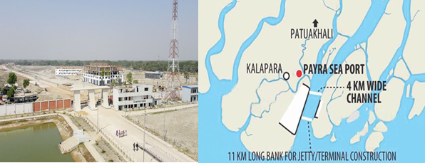
Payra Sea Port is the 3rd seaport of Bangladesh located in general area in between latitude 21.9890 North and longitude 90.2792 East on the bank of Rabnabad Channel under Kalapara, a sub district of Patuakali. In order to increase the economic activities in the central zone and meet the future demand, Payra Sea Port Act 2013 was passed in National Parliament on 10 November 2013. Honourable Prime Minister Sheikh Hasina inaugurated country’s 3rd seaport named as “Payra Sea Port” at Rabnabad Channel at Patuakhali district on 19 November 2013.
Government has taken Short, Mid & Long-Term Plan to develop a state of art modern seaport. As Short-Term Plan, Payra Port Authority is set operate the port activities by offloading cargos from motherships at outer/inner anchorage and transported to the hinterlands through river routes. All the necessary preparations like Custom Clearance Facilities, VHF communication, Banking, enlistment of Ship handling operators, C&F, Shipping agent, Channel Marking with Laying of Buoys at River and approach channel, Marking of Payra inner and outer Anchorage area, Implementation of ISPS code, UN Locator Code, and port security including a Bangladesh Coastguard station with high speed vessel and manpower etc have been completed.
Under Long Term Plan, by 2023 the port would be fully operational with a 16 m channel where minimum 10 km container & other terminals with all other associated facilities like establishing EEZ, Airport, Port city, Dockyard/Shipyard, Echo Tourism etc centring to the port. The Port authority has taken a mega budget estimate under the Long-term plan by phases to complete the envisioned infrastructural facilities and make the port fully operational by 2015.
Presently the port users are using River Route connecting to Dhaka and other districts of the country. In the river route, vessels more than 4-meter draught with bulk cargo are plying day and night irrespective of tide. Various commodities including food grain, cement, fertilizer and other bulk are transported from Payra to Dhaka and other destinations through internal waterways.
PPA’S objective focuses mainly on providing necessary services and facilities to the port users efficiently and effectively at competitive price. Though PPA started its Ltd scale port operations by offloading bulk cargoes at inner/outer anchorage, with the passage of time PPA is going to handle maximum volume of container and bulk cargoes of Bangladesh using the geographical advantages, good hinterland connectivity
Port website: http://ppa.gov.bd/
|
Port Location and Contact |
|
|---|---|
|
Country |
Bangladesh |
|
Province or District |
Patuakhali |
|
Nearest Town or City with Distance from Port |
Kalapara 5 km |
|
Port's Complete Name |
Port of Payra |
|
Latitude |
21.9890 N |
|
Longitude |
90.2792 E |
|
Managing Company or Port Authority |
Payra Port Authority |
Port Picture
List of Officers- PPA
|
Sl |
Name |
Designation |
Contact Details |
|---|---|---|---|
|
1 |
Commodore M Jahangir Alam, (E), NUP, ndc, psc, BN |
Chairman |
+88029348421 Fax:+88029349175 |
|
2 |
Commodore Md. Ashraful Haque Chowdhury, psc, BN |
Member (Harbour & Marine) |
|
|
3 |
Captain M. Muniruzzaman, (E), BN |
Member (Engineering and Development) |
02-9350125 |
|
4 |
Commander M Rafiul Hassain (TAS) psc, BN, (Rtd.) |
Member (Admin & Finance) |
02-9349175 |
|
5 |
Mohiuddin Ahmed Khan (Joint Secretary) |
Director (Administration) |
|
|
6 |
Md. Elias Reja |
Chief financial and accounting officer |
|
|
7 |
Quazi Wasif Ahmad |
Chief Engineer |
|
|
8 |
Commander Haider Jahan Khon Emon (H-1), psc, BN |
Chief Hydrographer |
|
|
9 |
Md. Nasir Uddin |
Deputy Ch. Engineer (Jetty & Harbour) |
|
|
10 |
Captain SM Sharifur Rahaman |
Dock Master |
|
|
12 |
Md. Saifur Rahman |
Joint Chief Planning |
|
|
13 |
Tayebur Rahman |
Deputy Director (Admin) |
|
|
14 |
Azizur Rahman |
Deputy Director (Traffic) |
|
|
15 |
Captain Asif Ahmed |
Pilot |
|
|
16 |
Mohammad Soadrul Amin |
Deputy Director, MIS |
|
|
17 |
Mostafa Ashique Ali |
Executive Engineer (Jetty) |
|
|
18 |
Md. Abul Kalam Azad Molla |
Executive Engineer (Harbour) |
|
|
19 |
Azizur Rahman |
Assistant Director (Admin) |
|
|
20 |
Md. Rajibul Hasan |
Assistant Director (Accounts) |
|
|
21 |
Md. Sohel Mir |
Assistant Director (Security) |
|
|
22 |
Md. Sajidul Islam Sobuj |
Assistant Secretary (Coordination) |
|
|
23 |
Md. Asadulla Ashik |
Assistant Engineer (Electrical) |
|
|
24 |
S M Imties Islam |
Superintendent (Light and Mooring) |
|
|
25 |
Md. Aminul Haque |
Assistant Chief (Prog) |
01515201401 |
|
26 |
Anup Kumar Sarker |
Medical Officer |
|
|
27 |
Delwar Hosen |
Personal Secretary |
|
|
28 |
Md. Rokibul Islam |
Security Officer |
Port Facilities and Infrastructure
Present Facilities of Port
As the port is under construction and lot of development works are going on to enrich the capacity and facilities of the port. However, some of the existing facilities are shown below:
|
Jetty |
ONE jetty (80M) to be used as service Jetty for own use and Cargo handling usage in small scale. |
|---|---|
|
Draught |
Maximum allowable draught of ships at Jetty is 6 M only |
|
Storage |
One Transit shed of 1,00,000 Sq. Ft |
|
Infrastructure |
Office/Admin building, Officer’s BOQ, Staff Accommodation, Multi-purpose Complex, Generator, Sub-station and some other small buildings and Shades have been constructed. |
|
Handling Equipment |
|
Port General Information
|
Port various Data
|
Hydrographic Data |
|
|---|---|
|
Salinity |
Salinity at Rabnabad Channel varies from 0.1 gms/1000c.c at low water to 0.2gms/ 1000c.c at high water during monsoons and from 2.5gms/1000c.c at low water to 16.5gms/1000c.c at high water during dry season. Salinity at Kajal river varies from 0.15gms/1000c.c at low water to 3.3gms/1000c.c at high water during monsoon and from 10gms/1000cc at low water to 27 gms/1000cc at high water during dry season. |
|
Width of Channel |
The width of the navigational channel (5.0m. contour) varies from place to place. From fairway to the mouth of Rabnabad Channel there is no restriction of Navigational width. A minimum of 250 m Channel width is maintained in Kajal- Tetulia route. |
|
Wind Velocity |
The weather in Bangladesh is largely governed by the monsoon. The prevailing wind directions are from South to South East during the months of April through September. After taking easterly direction for a while the wind turns to the northerly and north-easterly directions, the later prevail from November to January. During the months of February and March, winds turn via westerly direction back to the Southerly to South Easterly. In excess of 20 Knots/ Beaufort wind scale 5 prevails for 6 percent to time while those in excess of 30 Knots/Beaufort wind scale 7 persists for about 0.1 percent of the time during cyclones i.e. During the transition between monsoon and dry seasons in May, October, and November. The area of Payra port experienced four severe Cyclonic water surges during the last 44 years. In 1960 & 1963 speeds recorded were 125 Knots Max. In 1970 and 1991 speeds were recorded 138 Knots max. and 180 Knots max. respectively. |
|
Tidal Ranges |
The tides are important for navigations as determining the possibility of crossing the shallow area between Payra Fairway and the Meghna entrance at Hizla point and the Bars within Port Limit. The tides are semi-diurnal with prominent diurnal effect. The approx. Tidal Ranges at Rabnabad Channel and Amirganj (Meghna juncture) from Chart Datum (ISLWL – Indian Spring Low Water Level which is 1.673m below mean sea level) are as follows: At Rabnabad Channel: 0.8m.-3.5m. (above ISLWL) At Amirganj (Meghna juncture): 0.7m-2.8m. (above ISLWL). |
|
Night Navigation |
The entire channel is demarcated by let- buoys. There is no limitation for night navigation for entering/leaving harbour. |
|
Waves |
The waves are generally low shown distinct relation with the wind. Maximum wave heights over 2m were recorded only on a few days during the small parts of days. The wave periods vary between 3-4 seconds of waves of about 0.5m and about six seconds for waves of 2m. These are from an observation made by NEI (Netherlands Economic Institute) 1972–1977. During the months May to October freshets are expected, Freshets are caused by the normal velocity of flow of ebb tide augmented by the flow of an additional volume of water that drains into the river from the catchment area. Freshets are expected when rainfall intensity reaches 200mm in 24 hours. The density of water varies at each turn of the tide. Masters are advised to obtain the Circular from the local agents and follow the instructions closely. |
|
Anchorage |
A wide anchorage is established at the outer and inner Anchorage of PPA: LONGITUDE/LATITUDE
|
Port Performance
Before being fully operational the port has started its activities. Since Nov 2013 till Mar 2019 the port has managed following 32 ships:
|
Sl |
Name of Vessel |
Flag |
DWT |
L x B |
Draught |
D.O.A |
Quantity |
|---|---|---|---|---|---|---|---|
|
1 |
Banglar Mamata |
Bangladesh [BD] |
15,877 |
154.16m × 22.26m |
6.95m |
15-Nov-13 |
|
|
2 |
Fortune Bird |
Hong Kong [HK] |
55,640 |
189.99m × 32.26m |
6.80m |
1-Aug-16 |
20810MT |
|
3 |
FS Beach |
Vietnam [VN] |
8,215 |
136.4m × 20.2m |
7.00m |
14-Aug-16 |
12502MT |
|
4 |
Battang Hari 30 |
Indonesia [ID] |
1,630 |
95m × 19m |
5.00m |
6-Sep-16 |
1 unit |
|
5 |
Matsumae |
Panama [PA] |
9,998 |
124.56m × 21.2m |
5.00m |
27-Sep-16 |
106Pckg |
|
6 |
Kulsamut |
Thailand [TH] |
12,665 |
140.5m × 20.8m |
7.50m |
7-Oct-16 |
8000 MT |
|
7 |
Teng Hang |
Hong Kong [HK] |
35,023 |
179.88m × 28.4m |
7.30m |
17-Oct-16 |
26000 MT |
|
8 |
Combi Dock 1 |
Antigua Barbuda |
10,480 |
169.4m × 25.73m |
6.20m |
30-Oct-16 |
1 Unit |
|
9 |
Zealand Rotterdam |
Netherlands [NL] |
57,157 |
190m × 32.26m |
7.30m |
30-Jan-17 |
21195 MT |
|
10 |
Desert Unity |
Marshall Is [MH] |
54,043 |
189.99m × 32.26m |
7.30m |
2-Feb-17 |
14700 MT |
|
11 |
Canary |
Marshall Is [MH] |
57,825 |
189.99m × 32.3m |
6.60m |
14-Mar-17 |
17500 MT |
|
12 |
Safesea Neha II |
Liberia [LR] |
53,389 |
189.99m × 32.26m |
7.40m |
2-Oct-17 |
21300 MT |
|
13 |
Wish Way |
Panama [PA] |
21,243 |
156m × 36m |
7.00m |
25-Nov-17 |
1 Unit |
|
14 |
Dubai Ambassador |
Panama [PA] |
56,060 |
189.99m × 32.26m |
5.80m |
17-Dec-17 |
12000 MT |
|
15 |
Zhen Hua 15 |
Hong Kong [HK] |
46,671 |
233.3m × 42m |
8.30m |
4-Jan-18 |
6547.16 MT |
|
16 |
KSL Lake Hill |
Panama [PA] |
3,375 |
81m × 13.6m |
5.50m |
17-Jan-18 |
3000 MT |
|
17 |
Icarius |
Marshall Is [MH] |
55,921 |
189.99m × 32.26m |
7.05m |
10-Feb-18 |
20000 MT |
|
18 |
Kyriakos |
Panama [PA] |
29,926 |
171.45m × 27.02m |
6.95m |
26-Feb-18 |
14800 MT |
|
19 |
NK Khaleda |
Togo [TG] |
2,594 |
83.78m × 12.7m |
5.40m |
1-Mar-18 |
2400 MT |
|
20 |
Yin Fu |
China [CN] |
48,909 |
190m × 32.26m |
6.60m |
13-Apr-18 |
20000 MT |
|
21 |
Tan Binh 136 |
Vietnam [VN] |
29,887 |
170.7m × 27m |
7.20m |
19-Apr-18 |
17000 MT |
|
22 |
Knossos |
Malta [MT] |
56,763 |
189.99m × 32.26m |
7.30m |
12-Aug-18 |
22000 MT |
|
23 |
Development Way |
Panama [PA] |
31,287 |
215.00mx34.04m |
12.30m |
16-Oct-18 |
|
|
24 |
Sabada |
Moldova [MD] |
6,507 |
102.79mx17.03m |
7.15m |
12-Nov-18 |
6000 MT |
|
25 |
Equinox Agnandoussa |
Cayman Island [KY] |
58,680 |
197.00mx32.26m |
12.90m |
20-Nov-18 |
56810 MT |
|
26 |
Maria |
Marshall Is [MH] |
57,070 |
189.99mx32.26m |
12.10m |
30-Nov-18 |
50000 MT |
|
27 |
Tiger Hebei |
Hong Kong [HK] |
63,483 |
199.9m × 32.32m |
13.50m |
19-Dec-18 |
62,290 MT |
|
28 |
Mimi Selmer |
Marshall Is [MH] |
55,711 |
189.99m × 32.3m |
12.30m |
23-Jan-19 |
51,922 MT |
|
29 |
Xin Chen Hai Yang |
China [CN] |
24,242 |
153.46m × 38.6m |
6.00m |
31-Jan-19 |
4 Unit |
|
30 |
Sabada |
Moldova [MD] |
6,507 |
102.79mx17.03m |
6.93m |
19-Feb-19 |
6000 MT |
|
31 |
Sabada |
Moldova [MD] |
6,507 |
102.79mx17.03m |
6.95m |
17-Mar-19 |
6000 MT |
|
32 |
Ocean Bao |
Hong Kong [HK] |
63,577 |
199.9m × 32.26m |
12.80m |
27-Mar-19 |
58,306 MT |
Important News of the PPA
|
Sl |
Title |
|
1 |
|
|
2 |
|
|
3 |
List of Future development Projects
|
Sl |
Project Name |
|---|---|
|
1 |
Developing Infrastructure Support Facilities (DISF) |
|
2 |
PPA Master Plan |
|
3 |
Payra Port First Terminal (PPFT) |
|
4 |
Rabnabad Channel Capital and Maintenance Dredging of Payra Port |
|
5 |
Coal/Bulk Terminal (CBT) |
|
6 |
Multipurpose Terminal (MPT) |
2.1.4 Bangladesh Port of Matarbari
Port Overview
Matarbari Port is a proposed deep seaport in Matarbari, Cox's Bazar District, Chattogram Division, Bangladesh. The port will be full commercial opening by expanding Coal jetty for berthing of vessels for the Maheshkhali power plant in Cox's Bazar district. At least 16.3-meter-deep ships can be easily accessible Matarbari Port. With the depth of the proposed Matarbari port being 16.3 meters, every ship will be able to bring more than 8000 containers. Currently, vessels with less than a 9-meter draft can call at the country’s two seaports at Chattogram and Mongla.
JICA will build a 15-kilometer long channel for construction of Matarbari port. Main navigational channel will be 350 meters wide. The 100-meter-long jetty will be constructed under the port's financing. The deep seaport’s multi-purpose terminal will be ready for container shipping vessels by November 2022, and a coal terminal will be constructed by August 2022
In the first phase of construction, the container terminal will be built on 18 hectares, have a 460-meter berth, be able to accommodate 8,000 TEU vessels, and have an annual capacity of 600,000 to 1.1 million TEU. Later, the container terminal will be expanded, comprise 70 hectares, have an 1,850-meter berth, and have a 2.8-million-MT capacity. The multi-purpose terminal will be built on 17 hectares, have a 300-meter berth, and be able to accommodate vessels with up to 70,000 dwt. Its annual capacity will be 2.25 million tonnes
Key port information may also be found at: http://www.maritime-database.com.
Port Picture
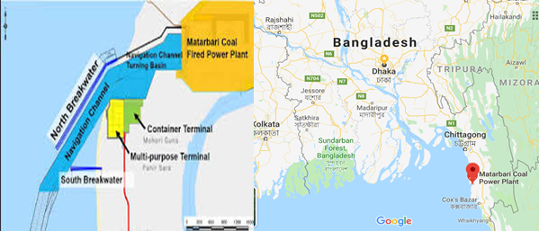
Matarbari Deep Sea port at a glance
|
Port Location and Contact |
|
|---|---|
|
Country |
Bangladesh |
|
Province or District |
Maheshkhali Upazila, Cox’s Bazar |
|
Port's Complete Name |
Port of Matarbari |
|
Latitude |
21.6914°N |
|
Longitude |
91.8590°E |
|
Managing Company or Port Authority |
Matarbari Port Authority |
|
To be opened |
2023 |
|
Type of harbor |
Deep sea port |
|
Length of Nav channel |
15-kilometer |
|
wide of Nav channel |
350 meters |
|
Draught |
16.3 meters |
Envision of the port
In the first phase of stage one, according to JICA's presentation, the port will have annual handling capacity of 0.8 million TEUs of containers and 2.5 million tonnes of bulk cargos. The port will be connected to the national highway and also have access to Chattogram and Cox's Bazar.
In the second phase of stage one, the port will have three jetties ready for container handling and four to six jetties for multipurpose use by 2028. Meanwhile, its container handling capacity will grow to 2.8 million TEUs and cargo handling capacity will reach 2.5 million tonnes per year.
After the completion of the final stage by 2035, the port will have the capacity to handle 4.8 million TEUs of containers and 16 to 38 million tonnes of bulk cargos. By 2024, the port will have rail connectivity through Dohazari-Cox's Bazaar line. An inland container depot will also be built by then.
By 2035, the container terminal's berth will reach 1,850-metre on 70 hectares area. Japan has agreed to invest US$20 billion for Moheshkhali-Matarbari initiative, of which half will come from its low-cost ODA (official development assistance). The rest will come as private sector investment.