2 Georgia Logistics Infrastructure
Georgia Logistics Infrastructure
The following sections contain information on the logistics infrastructure of Georgia
2.1 Georgia Port Assessment
Georgia Port Assessment

For information on Georgia Port contact details, please see the following link:
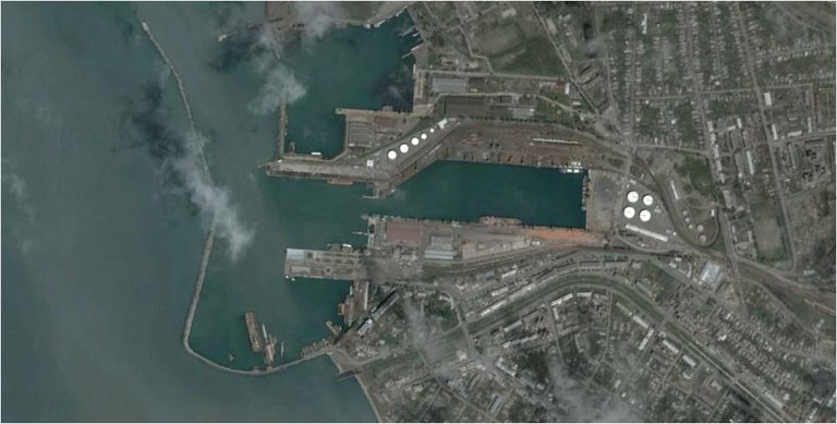
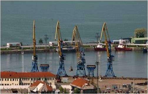
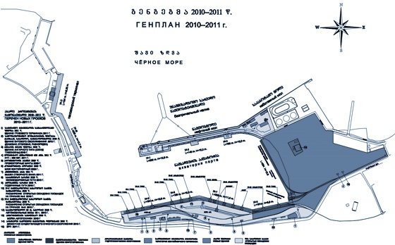
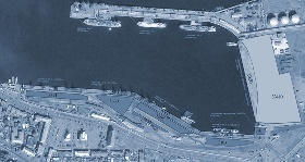
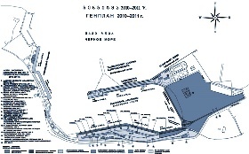
2.1.1 Georgia Port of Poti
Key port information can also be found at: Maritime Database information on Georgia
Port Overview
Port Poti is on a plain, where the Rioni River empties into the
Black Sea, 265 km northwest of Tbilisi, with its geographical
location represents a crossroad of the Caucasian corridor
Nowadays the port is equipped with modern cargo handling facilities
and in line with the European standards
The port has open and closed warehouses, supportive constructions,
8 cargo handling complex located at 15 berths at the “northern
port” and “inner basin”, passenger station and berths for the
fishing fleet
The Port of Poti has all the conditions to satisfy client’s
different requirements regarding cargo and passenger carriage
Port website: Georgia Port of Poti Website
|
Port Location and Contacts |
|
|---|---|
|
Country |
Georgia |
|
Province or District |
Samegrelo |
|
Town or City (Closest location) with Distance (km) |
Name: Poti km: n/a |
|
Port's Complete Name |
Port of Poti |
|
Latitude |
42.15406 |
|
Longitude |
41.66006 |
|
Managing Company or Port Authority (If more than one operator, break down by area of operation) |
Poti Sea Port Corporation |
|
Management Contact Person |
Rony Saab |
|
Closest Airport and Frequent Airlines to / from International Destinations |
Airport Name: n/a Airlines: n/a |
Port Picture
Description and Contacts of Key Companies
For information on Georgia Port of Poti contact details, please see the following link:
4.3 Georgia Port and Waterways Company Contact List
Port Performance
For information on Poti Port performance, please see the following documents:
Port of Poti export - import activity
Georgia Port of Poti Additional Information
Note: The information provided in the attached documents, which has been taken from the old DLCA, does not match the structure of the new LCA and is therefore provided separately.
|
Handling Figures |
Year 2010 |
|---|---|
|
Vessel Calls |
2,189 |
|
Container Traffic (TEUs) |
n/a |
Discharge Rates and Terminal Handling Charges
Port tariffs are determined in accordance with the Maritime Code
of Georgia, Civil Code of Georgia, Georgian law and other
legislative acts relating to transport rules and regulations
according to the legislative normative act. Tariffs are
established according to the vessel conditional volume, which is
determined with international measurement certificate or according
to - LOA of vessel, breadth and moulded depth. Barges and
other floating objects combination volumes are determined as sum of
separate elements. All charges for services should be paid by
forwarder (ship-owner, freighter) or by vessel agent before any
vessel leaves from port.
In the case of non-payment of service tariffs and fines, the Port
Administration Office will provide written notice and the Harbour
Master who is permitted to refuse permission for the vessel to
leave the port. Lighter ships, which carry out loading
operations on internal and external roadstead, pay tariffs
according to the lighter volume, which will be given at time of
vessel call in port and will receive at time of leaving the
port.
Services which are conducted during holidays incur a 25% surcharge
for every vessel. Holidays are defined according to the labour
law of Georgia. All kinds of service should be in detail
decoded in the bill presented to ship-owner, included service
carried out during the holidays.
For the calculation of service fees, times rounded-up for each 30
minutes. Therefore, less than 30 minutes will be counted as half an
hour and more than 30 minutes will be charged as 1
hour. Payment of tonnage, channel, berthing, sanitary
inspection service and watchman tariffs are carried out once and
will be paid per operation, by which a vessel arrived to the
port.
For information on Georgia Port of Poti Charges, please see the following links:
Georgia Port of Poti Additional Information
Note: The information provided in the attached documents, which has been taken from the old DLCA, does not match the structure of the new LCA and is therefore provided separately.
Berthing Specifications
|
Type of Berth |
Quantity |
Length (m) |
Maximum Draft (m) |
|---|---|---|---|
|
Conventional Berth |
n/a | n/a | n/a |
|
Container Berth |
n/a | n/a | n/a |
|
Silo Berth |
n/a | n/a | n/a |
|
Berthing Tugs |
1-2 engine x 1,775 HP 1-2 engine x 1,200 HP 1-2 engine x 600 HP 1-2 engine x 480 HP |
||
|
Water Barges |
1 Anti-pollution Boats: 1 Speed Boats: 2 |
For information on Georgia Port of Poti Berthing Specifications, please see the following documents:
Port of Poti berthing facilities
Georgia Port of Poti Additional Information
Note: The information provided in the attached documents, which has been taken from the old DLCA, does not match the structure of the new LCA and is therefore provided separately.
General Cargo Handling Berths
|
Cargo Type |
Berth Identification |
|---|---|
|
Imports - Bagged Cargo |
8, 9, 10(see below drawing Nº 1) |
|
Exports - Bagged Cargo |
8, 9, 10 (see below drawing Nº 1) |
|
Imports and Exports - RoRo |
(see below drawing Nº 1) |
|
Other Imports |
Steel Goods - (see below drawing Nº 1) Vehicles - (see below drawing Nº 1) |
Port Handling Equipment
Is the port equipment managed by the government or privately? Managed by Port of Poti
For information on Georgia Port of Poti Port Handling Equipment, please see the following document:
Georgia Port of Poti Additional Information
Note: The information provided in the attached documents, which has been taken from the old DLCA, does not match the structure of the new LCA and is therefore provided separately.
Container Facilities
|
Facilities |
20 ft |
40 ft |
|---|---|---|
|
Container Facilities Available |
Yes |
Yes |
|
Container Freight Station (CFS) |
Yes - 3 | Yes - 3 |
|
Refrigerated Container Stations |
Yes | Yes |
|
Other Capacity Details |
||
|
Daily Take Off Capacity (Containers per day) |
n/a | |
|
Number of Reefer Stations (connection points) |
1 | |
|
Emergency Take-off Capacity (Give an indication) |
n/a | |
|
Off take capacity of gang shift (in Containers per shift) |
n/a | n/a |
Customs Guidance
For information on Georgia Port of Poti Customs Guidance, please see the following link:
1.3 Georgia Customs Information
Terminal Information
Storage: Main Quay Transit Sheds x 8 (69,000 m²)
Grain and Bulk Handling
The Port of Poti has no functional bagging equipment
Port Security
|
Security |
||
|---|---|---|
|
ISPS Compliant (Yes / No) |
yes |
|
|
Current ISPS Level |
Normal (1) |
Level 1 = Normal, Level 2 = Heightened, Level 3 = Exceptional |
|
Police Boats |
1 | |
|
Fire Engines |
n/a |
For information on Georgia Port of Poti, please see the following documents:
Georgia Port of Poti Additional Information
Note: The information provided in the attached documents, which has been taken from the old DLCA, does not match the structure of the new LCA and is therefore provided separately.
2.1.2 Georgia Port of Batumi
Key port information can also be found at: Maritime Database information on Georgia
Port Overview
The Port of Batumi is only 15 km from the border with Turkey in the Autonomous Republic of Adjara. The port has 12 berths, four of which can be used for the unloading cereal cargo, either in bulk or in bags. The port has gradually specialised itself in the export of petroleum products that reach Batumi from Azerbaijan by rail and pipeline. The Port of Batumi serves as an alternative to the Port of Poti, but is less well served by the Georgian railways which has only a single rail serving as railway link for the port/quays. The freight costs from Batumi are also higher than those from Poti. Batumi faces the same weather constraints as Poti, i.e. wind and rain in autumn that can affect to some extend the entrance of vessels in the port.
Port website: Port of Batumi Website
|
Port Location and Contacts |
|
|---|---|
|
Country |
Gerogia |
|
Province or District |
Adjara |
|
Town or City (Closest location) with Distance (km) |
Name: Batumi km: n/a |
|
Port's Complete Name |
Port of Batumi |
|
Latitude |
41.64833 |
|
Longitude |
41.65278 |
|
Managing Company or Port Authority (If more than one operator, break down by area of operation) |
G&M Logistic Co Ltd |
|
Management Contact Person |
+995 (422) 27-62-61 |
|
Closest Airport and Frequent Airlines to / from International Destinations |
Airport Name: n/a Airlines: n/a |
Description and Contacts of Key Companies
For information on Georgia Port of Batumi contact details, please see the following link:
4.2.4Georgia Port and Waterways Company Contact List
Port Performance
Bagged cargo is discharged at a maximum rate of 1,000 mt for two hatches per day. In reality, often lower rates are achieved – especially a result of the delays obtained by waiting for railway wagons. Bulk cargo is discharged at some 2,000 mt for two hatches, again facing the same constraints. Containers can be discharged in Batumi, but with quite a lot of effort, as no facilities are available and the vessel’s cranes have to be used in combination with the shore cranes (which are not in optimum condition). There is no specialised container terminal in the port. Cereal cargo – and other bagged cargo – is normally discharged directly into railway wagons, as the –open – storage space in the port is limited. There is no functional covered storage space inside the port complex.
For information on Georgia Port of Batumi additional details, please see the following documents:
Port of Batumi Dry Cargo Turnover
Note: The information provided in the attached documents, which has been taken from the old DLCA, does not match the structure of the new LCA and is therefore provided separately.
2.1.3 Georgia Kulevi Oil Terminal Port
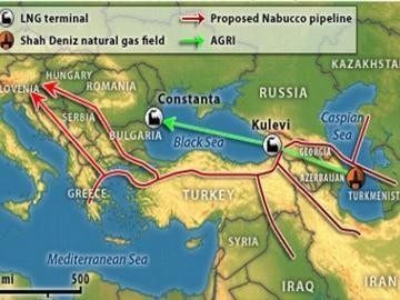
Key port information can also be found at: Maritime Database information on Georgia
Port Overview
The Kulevi Oil Terminal is an oil port in Kulevi, Georgia, located on the eastern Black Sea coast. Its annual capacity is 10 million tons of crude oil and refined products. Kulevi Oil Terminal incorporates three piers, a canal for tankers, a mobile service fleet of 9 vessels, and a laboratory for oil and refined products testing. The terminal is able to receive up to 168 tank cars at the same time, through four railway branches.
Port website: Kulevi Oil Terminal Port Website
|
Port Location and Contacts |
|
|---|---|
|
Country |
Georgia |
|
Province or District |
Khobi District |
|
Town or City (Closest location) with Distance (km) |
Name: n/a km: n/a |
|
Port's Complete Name |
Kulevi Oil Terminal Port |
|
Latitude |
42.27 |
|
Longitude |
41.64 |
|
Managing Company or Port Authority (If more than one operator, break down by area of operation) |
n/a |
|
Management Contact Person |
n/a |
|
Closest Airport and Frequent Airlines to / from International Destinations |
Airport Name: n/a Airlines: n/a |
For information on Georgia Port contact details, please see the following link:
2.2 Georgia Aviation
Georgia Aviation

Key airport information may also be found at: World Aero Data information on Georgia
For information on Georgia Airport contact details, please see the following link:
4.4 Georgia Airport Company Contact List
Procedures for Foreign Registered Aircraft
2.2.1 Georgia Tbilisi International Airport
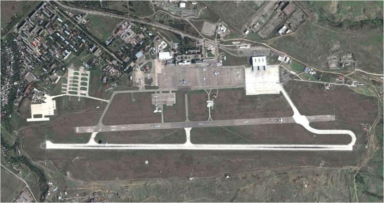
Tbilisi International Airport is the main international airport in Georgia, located 17 km southeast of the capital Tbilisi. Tbilisi Airport is the largest airport of Georgia along with Batumi Airport (also operated by the TAV Airports) – are the only airports in Georgia. Together the airports serve the catchments of 4.7 million.
| Location Details | |||
|---|---|---|---|
| Country | Georgia | Latitude | 41.669167 |
| Province / District | Tbilisi | Longitude | 44.954722 |
| Town or City (Closest) | Tbilisi | Elevation (ft and m) | 1,624 ft / 495 m |
| Airfield Name | Tbilisi International Airport | IATA and ICAO Codes | TBS & UGTB |
| Open From (hours) | 00:00 | Open To (hours) | 00:00 |
Runways
|
Runway #1 |
|
|---|---|
|
Runway Dimensions |
3,000m x 45m |
|
Orientation |
13/31 |
|
Surface |
Concrete to ICAO standards |
|
Runway #2 |
|
|---|---|
|
Runway Dimensions |
2,500m x 60m |
|
Orientation |
13/31 |
|
Surface |
Concrete/Asphalt to ICAO standards |
NOTE: Runway Capacity: 12 flights/hour, Operating hours: 24/7
Helicopter Pad(s)
|
Helipad #1 |
|
|---|---|
|
Present (Yes / No) |
Yes |
|
Largest helicopter that can land |
Mi-26 |
|
Width and Length (metres) |
50 x 50 |
|
Surface |
Asphalt & Concrete |
Airport Infrastructure Details
|
Customs |
Yes |
JET A-1 fuel |
Yes |
|---|---|---|---|
|
Immigration |
Yes |
AVGAS 100 |
Yes |
|
Terminal Building |
Yes |
Single Point Refueling |
Yes |
|
Passenger Terminal |
Yes |
Air Starter Units |
Yes |
|
Cargo terminal |
Yes |
Ground Power (mobile) |
Yes |
|
Pax transport to airfield |
No |
Ground Handling Services |
Yes |
|
Control Tower |
Yes |
Latrine Servicing |
Yes |
|
Weather Facilities |
Yes |
Fire Fighting Category (ICAO) |
Yes |
|
Catering Services |
Yes |
De-icing Equipment |
No |
|
Base Operating Room |
Yes |
Parking Ramp Lighting |
Yes |
|
Airport Radar |
Yes |
Approach & Runway Lights |
Yes |
|
NDB |
Yes |
VOR |
Yes |
|
ILS |
Yes |
|
Passenger and Cargo Performance Indicator
One terminal; entirely reconstructed in 2007 including a car park, improvements to the apron, taxiway, runway and new ground handling equipment
|
Performance for 2008 |
Annual Figures |
Monthly* | Daily* |
|---|---|---|---|
|
Total aircraft movements |
n/a | n/a | n/a |
|
Total passengers |
715,000 (99% International) | 59,583 | 1,959 |
|
Total capacity of the airport (metric tonnes) |
10,000 | 833 | 69 |
|
Current activity of the airport (metric tonnes) |
n/a | n/a | n/a |
|
Current use by Humanitarian flights (UNHAS) |
Not used by UNHAS | n/a | n/a |
*Monthly and daily figures have been calculated using the annual figures provided in the old DLCA
Airport Operating Details
| Operating Details | |||
|---|---|---|---|
| Maximum sized aircraft which can be offloaded on bulk cargo: | An-124 | ||
| Maximum sized aircraft that can be offloaded on pallet | No limit | ||
| Total aircraft parking area (m²) | 270,500 m² | ||
| Storage Area (mt) | 10,000 mt | Cubic Meters (m³) | n/a |
| Cargo Handling Equipment Available (Yes / No) | Yes | If "Yes" specify below | |
| Elevators / Hi Loaders (Yes / No) | Yes | Max Capacity (mt) | 3.0 |
| Can elevators / hi loaders reach the upper level of a B747 (Yes / No) | Yes | ||
| Loading Ramps (Yes / No) | n/a | ||
Storage Facilities
The airport has two cargo terminals: one is part of the airport complex itself while the other "Lasare" is positioned immediately next to the airport area. Both terminals are fully equipped with handling equipment, tools, trucks etc. The customs operate in both terminals.
Airfield Cost
For information on Georgia Tbilisi International Airport additional charges, please see the following document:
Georgia Tbilisi Airport Passenger Service Charges
Note: The information provided in the attached documents, which has been taken from the old DLCA, does not match the structure of the new LCA and is therefore provided separately.
Fuel Services Charges
US$ 0.62 per litre*
*Charges correct as of 1st Aug 2009
Air-bridge Charges
There are no air-bridges in Georgia
Security
Good
Companies Available
For information on Georgia Tbilisi International Airport contact details, please see the following link:
4.4 Georgia Airport Company Contact List
Information on some aviation service providers can be found at: AZ Freight information on Georgia
2.2.2 Georgia Batumi National Airport
|
Airport Details |
|||
|---|---|---|---|
|
Country |
Georgia |
Latitude |
41.60667 |
|
Province / District |
Batumi |
Longitude |
41.6 |
|
Airport Name |
Batumi |
Elevation (ft) |
11 feet |
|
IATA & ICAO codes |
BUS & UGSB |
Surface |
Asphalt |
|
Town or City (closest) |
Batumi |
Runway Condition |
n/a |
|
NGO / UN (on ground) |
n/a |
Passenger / Cargo Security Screening (Yes / No) |
n/a |
|
Runway Dimension |
2,600m x 45m |
Ground Handling (Yes / No) |
n/a |
|
Refueling Capacity |
n/a |
Runway Lighting (Yes / No) |
Yes |
|
Runway Heading |
n/a |
Fire Fighting Equipment (Yes / No) |
n/a |
|
Air Traffic Control (Yes / No) |
n/a |
Windsock (Yes / No) |
n/a |
|
Weather Information (Yes / No) |
n/a |
Aircraft Parking space (Yes / No) |
n/a |
|
Navigation Aids (Yes / No) |
n/a |
Perimeter fencing (Yes / No) |
n/a |
For information on Georgia Batumi National Airport contact details, please see the following link:
2.2.3 Georgia Kutaisi National Airport
|
Airport Details |
|||
|---|---|---|---|
|
Country |
Georgia |
Latitude |
42.17833 |
|
Province / District |
Kutaisi |
Longitude |
42.46833 |
|
Airport Name |
Kutaisi |
Elevation (ft) |
223 feet |
|
IATA & ICAO codes |
KUT & UGKO |
Surface |
Asphalt |
|
Town or City (closest) |
Kutaisi |
Runway Condition |
n/a |
|
NGO / UN (on ground) |
n/a |
Passenger / Cargo Security Screening (Yes / No) |
n/a |
|
Runway Dimension |
2,500m x 44m |
Ground Handling (Yes / No) |
n/a |
|
Refueling Capacity |
n/a |
Runway Lighting (Yes / No) |
Yes |
|
Runway Heading |
n/a |
Fire Fighting Equipment (Yes / No) |
n/a |
|
Air Traffic Control (Yes / No) |
n/a |
Windsock (Yes / No) |
n/a |
|
Weather Information (Yes / No) |
n/a |
Aircraft Parking space (Yes / No) |
n/a |
|
Navigation Aids (Yes / No) |
n/a |
Perimeter fencing (Yes / No) |
n/a |
For information on Georgia Batumi National Airport contact details, please see the following link:
2.2.4 Georgia Senaki Kolkhi National Airport
|
Airport Details |
|||
|---|---|---|---|
|
Country |
Georgia |
Latitude |
42.24 |
|
Province / District |
Zugdidi |
Longitude |
42.05 |
|
Airport Name |
Senaki Kolkhi National Airport |
Elevation (ft) |
550 feet |
|
IATA & ICAO codes |
SSS |
Surface |
Asphalt |
|
Town or City (closest) |
Senaki Kolkhi |
Runway Condition |
n/a |
|
NGO / UN (on ground) |
n/a |
Passenger / Cargo Security Screening (Yes / No) |
n/a |
|
Runway Dimension |
2,400m x 40m |
Ground Handling (Yes / No) |
n/a |
|
Refueling Capacity |
n/a |
Runway Lighting (Yes / No) |
Yes |
|
Runway Heading |
n/a |
Fire Fighting Equipment (Yes / No) |
n/a |
|
Air Traffic Control (Yes / No) |
n/a |
Windsock (Yes / No) |
n/a |
|
Weather Information (Yes / No) |
n/a |
Aircraft Parking space (Yes / No) |
n/a |
|
Navigation Aids (Yes / No) |
n/a |
Perimeter fencing (Yes / No) |
n/a |
For information on Georgia Batumi National Airport contact details, please see the following link:
2.2.5 Georgia Babushara National Airport
|
Airport Details |
|||
|---|---|---|---|
|
Country |
Georgia |
Latitude |
42.855 |
|
Province / District |
Sukhumi, Abkhazia |
Longitude |
41.12333 |
|
Airport Name |
Babushara |
Elevation (ft) |
53 feet |
|
IATA & ICAO codes |
SUI & UGSS |
Surface |
Concrete |
|
Town or City (closest) |
Babushara |
Runway Condition |
n/a |
|
NGO / UN (on ground) |
n/a |
Passenger / Cargo Security Screening (Yes / No) |
n/a |
|
Runway Dimension |
3,600m x 40m |
Ground Handling (Yes / No) |
n/a |
|
Refueling Capacity |
n/a |
Runway Lighting (Yes / No) |
Yes |
|
Runway Heading |
n/a |
Fire Fighting Equipment (Yes / No) |
n/a |
|
Air Traffic Control (Yes / No) |
n/a |
Windsock (Yes / No) |
n/a |
|
Weather Information (Yes / No) |
n/a |
Aircraft Parking space (Yes / No) |
n/a |
|
Navigation Aids (Yes / No) |
n/a |
Perimeter fencing (Yes / No) |
n/a |
For information on Georgia Batumi National Airport contact details, please see the following link:
2.3 Georgia Road Network
Georgia Road Network

For information on Georgia road network contact details, please see the following link:
4.1 Georgia Government Contact List
The condition of the highways in Georgia is reasonably good. When road conditions are poor on the major roads, four wheel drive vehicles are advisable. Especially during winter snow, fog and ice can be a problem in the mountainous parts of the country. In mountainous regions the roads can be narrow and slopes are sometimes steep, which in combination with bad conditions can limit the cargo that can be transported, this however is only the case in specific regions like Lechkhumi, Upper Swaneti, mountainous part of Racha and Imereti
There is sufficient transport capacity in the country, which consists mainly Soviet built trucks (Gaz, Kamaz, Ural, Maz) including 4x4 and 6x6 wheel drive trucks with capacity varying from 10 mt to more than 30 mt. The highways can easily handle these large trucks including trailers. On specific mountain roads the capacity is limited to about 10 mt or less depending on the slope and road conditions. During the winter period, mountainous roads can be subjected to fog and snow, making them difficult to negotiate. The spring rains and/or melting snow can make minor mountain road covered by mud.
The main road transport route through Georgia runs from the border with Turkey in Sarpi along the coast to Ureki (S-2), from where it cuts eastwards via Samtredia (S-12), Kutaisi (S-1), Zestaphoni, Khasuri and Gori to Tbilisi. Beyond Tbilisi the highway splits in a route along Rustavi (S-9 and S-4) to the border with Azerbaidjan and another to the border with Armenia (S-6 and S-7). Another highway route goes from Tbilisi to the Kaheti region (S-5). The “Military Highway” (S-3) goes north from Tbilisi up the Kazbegi pass where it crosses into Russia. Due to the existing political and security situation, the Roki tunnel (S-10) in South-Ossetia and the border crossing point in Leselidze in Abkhzia (S-1) are not accessible for regular road transport originating from Georgia proper. Another secondary highway route runs along the Turkish border from Sarpi to Akhaltsikhe, from where it joins the Kutaisi – Tbilisi highway via Borjomi at Khasuri. The main border crossing with Turkey is in Sarpi at the Black Sea coast. A less frequently used, but still important border crossing point with Turkey is Vale, a few kilometers from Akhaltiskhe. The main border crossings with Armenia are at Sadakhlo and Mughalo. Trucks coming from Turkey in Vale tend to use the short cut into Armenia via Akhakalaki and Ninotsminda (S-11)
All these highways – with the exception of those crossing mountain passes (S-3 and S-5 and the route from Sarpi along the Turkish border) – can be used by large trucks with 20 mt – or more – capacity all through the year. There is no toll levying on the highways, though foreign registered vehicles need to pay a kind of road tax when entering the country. The S-1 highway has a tunnel – with alternative mountain trail – between Zestaphoni and Khashuri for which a small toll fee is levied. All river crossings are by means of bridges, not ferries.
Distance Matrix
| Tbilisi | Gori | Kutaisi | Rustavi | Batumi | Poti | |
|---|---|---|---|---|---|---|
| Tbilisi | - | 86 | 236 | 30 | 380 | 334 |
| Gori | 86 | - | 150 | 116 | 294 | 248 |
| Kutaisi | 236 | 150 | - | 266 | 144 | 98 |
| Rustavi | 30 | 116 | 266 | - | 410 | 364 |
| Batumi | 380 | 294 | 144 | 410 | - | 76 |
| Poti | 334 | 248 | 98 | 364 | 76 | - |
| Tbilisi | Gori | Kutaisi | Rustavi | Batumi | Poti | |
|---|---|---|---|---|---|---|
| Tbilisi | - | 1.0 h | 3.0 h | 0.3 h | 5.0 h | 4.2 h |
| Gori | 1.0 h | - | 2.3 h | 1.3 h | 4.0 h | 3.2 h |
| Kutaisi | 3.0 h | 2.3 h | - | 3.3 h | 2.0 h | 1.2 h |
| Rustavi | 0.3 h | 1.3 h | 3.3 h | - | 5.3 h | 5.0 h |
| Batumi | 5.0 h | 4.0 h | 2.0 h | 5.3 h | - | 1.2 h |
| Poti | 4.2 h | 3.2 h | 1.2 h | 5.0 h | 1.2 h | - |
Road Class and Surface Conditions
| Classification | Description |
|---|---|
|
Class RN: Asphalt-concrete, pavement of gravel and crushed
stone
|
Category: I: 13km, II: 786 km, III: 180 km, IV: 422 km, V: 94
km
|
|
Class RD: Asphalt-concrete, pavement of gravel and crushed
stone, roads of virgin soil
|
Category: IV: 3,310 km, V: 1,2170 km
|
|
Class UR: Asphalt-concrete, pavement of gravel and crushed
stone, roads of virgin soil
|
Category: II: 42 km, III: 266 km, IV: 1,839 km, V: 1,207
km
|
For information on Georgia Road network additional information, please see the following document:
Note: The information provided in the attached documents, which has been taken from the old DLCA, does not match the structure of the new LCA and is therefore provided separately.
2.4 Georgia Railway Assessment
Georgia Railway Assessment

Georgian Railway LLC (GR) intends to improve the safety and
efficiency of their railway operations by constructing a new
section of railway track bypassing the central part of Tbilisi and
upgrading the existing stations of Didube and Navtlughi. GR has
approached the European Bank for Reconstruction and Development
(EBRD) and the European Investment Bank (EIB) to finance the
Tbilisi Railway Bypass project.
According to Georgian law, the potential environmental impacts of
the project must be evaluated by an Environmental Impact Assessment
(EIA) process and documented in an environmental impact statement.
As part of their decision-making process, EBRD and EIB require an
evaluation of the proposed project through an Environmental and
Social Impact Assessment (ESIA) that meets EBRD and some other
international guidelines. The development of both, the Georgian EIA
and EBRD’s ESIA are being consolidated into one process and
documented in this single report.
The railroad is the main mode of transport for cargo that arrives in Georgia through the ports of Poti and Batumi. The Georgian railroad also serves the two other landlocked south Caucasus countries of Armenia and Azerbaijan. There is also a link with the Russian Federation that runs through the rebellious region of Abkhazia and which therefore is in disuse
From the coast the railroad travels through West Georgia via the
town of Kutaisi, through the mountains, to Tbilisi. From here it
travels further to Yerevan in Armenia and Baku in
Azerbaijan. There are also a number of minor lines servicing
the major towns of the different regions in Georgia. The
freight transportation maximum in Caucasus (Georgia and Armenia)
was in 1985 and reached 63.1 million mt
However, after disintegration of a former USSR economical links
were broken up and freight transportation fell down to 4.6 million
mt by 1995 but in the following years the volume moved
increased
Specific gravity of Georgian railway in every kind of the freight transportation is about 90%. Existing technical equipment makes possible Georgian railway to transit 25-30 million mt of cargo per year. Within the Georgian setting the railways can be considered as one of the few (semi-) Government systems that operate quite efficiently. This is among others the result of the realization that due to its strategic position relative to the two other Southern Caucasus countries, it has a major role as transit country with the nearest port. In addition, construction of the new link connecting Azeri and Georgian railway systems to turkey has been agreed between the 3 countries but construction has not started yet due to tender announcement
Railway Companies and Consortia
For information on Georgia Railway company contact details, please see the following link:
4.9 Georgia Railway Company Contact List
For information on Georgia Railway additional details and pictures, please see the following document:
Georgia Railway Additional Info
Note: The information provided in the attached documents, which has been taken from the old DLCA, does not match the structure of the new LCA and is therefore provided separately.
2.5 Georgia Waterways Assessment
Georgia Waterways Assessment

The longest rivers in Georgia are:
1. Alazani – 390 km in length with a catchment basin of 12,000
km²
2. Kura – 351 km in length with a catchment basin of 21,100 km²
3. Rioni – 333 km in length with a catchment basin of 13,400
km²
4. Enguri – 206 km in length with a catchment basin of 4,100
km²
The biggest lakes in Georgia are:
1. Paravan – with a surface area of 37.5 km³
2. Kartsakhi – with a surface area of 26.3 km³
Waterways of Georgia
Water supply in the country is on the average level and a safe drinking water supply is the key component of the general objective to ensure the environmental safety and health of people in Georgia. At present, all 85 cities and districts of Georgia are provided with centralized water systems. There are a total of 156 major water intakes. Drinking water is mainly withdrawn from the ground sources. A total design capacity of the ground drinking water sources is 3.1 million m³ a day. Waste water discharge systems operate in 41 cities and districts, 30 of which have waste water treatment plants of total design capacity equal to 1.6 million m³ a day (including regional treatment facilities in Gardabansky District with a capacity of 1.0 million. m³ a day, which serve Tbilisi and Rustavi). The total length of waterways and water distribution networks in Georgia is 9,500 km and a length of wastewater networks and sewers is 4,000 km
2.6 Georgia Storage Assessment
Georgia Storage Assessment
During the Soviet days warehouses were set up in all major urban centres of Georgia. With the collapse of the Soviet Union, much of the infrastructure has become dysfunctional. Many of these warehouses have access to the railroad. Every major town along the railroad network has warehouses with railway access. Should warehousing capacity still be short, one could look into a number of the factory buildings that are no longer in use. Some improvements (cleaning, removal of hardware, installing of security devises etc.) will be necessary, but it should be cheaper than importing mobile storage units, such as Wiikhalls, and the like. As a result of the industrial past of the country during the Soviet days and the high unemployment rate, it is not difficult to find skilled labourers. Warehouse management staff and logisticians generally need some training, but with the gradual increasing activities of a number of Western Joint Venture companies, skilled staff becomes more available.
Commercial Storage
| Location | Owner | Available for rent | Capacity | Type | Access | Condition |
|---|---|---|---|---|---|---|
|
Tsekavshiri Universal Trade Base, 4 Uimashevi Street,
Tbilisi, Georgia
|
State
|
Yes
|
20,000 m²
|
Concrete
|
Raised siding
|
Repair
|
|
Georgian Trans Expedition Terminal, 1 Kokaia Alley,
Poti, Georgia
|
Georgian Trans Expedition
|
Yes |
16,500 m²
|
Concrete
|
N/A
|
Repair
|
[1] Warehouse Type: Open storage, container, rub-hall, silo, concrete, other, unspecified
[2] Warehouse Access: Raised-siding, flat
[3] Warehouse condition: Appears intact, appears damaged, under construction/repair
Storage Used by Humanitarian Organizations
| Location | Organisation | Sharing possibility | Capacity | Type | Access | Condition |
|---|---|---|---|---|---|---|
|
Tbilisi, Lilo 1
|
WFP
|
Yes
|
3,605 m²
|
Concrete
|
Raised-siding
|
Good
|
2.7 Georgia Milling Assessment
Georgia Milling Assessment
All main milling listed below were constructed during the Soviet time. Specifications and requirement of these mills were according to ex-Soviet standards. All mills have railway sidings for delivery of wheat grain from the port. Most of them are partly operational. due to old age of milling machinery, low demand and uncompetitive milling cost compared to newly constructed small capacity mills these factories never reach their maximum milling capacities
| Location | Mill | Distance from Tbilisi | Milling (mt/day) | Grain Storage (mt) | Blending | Fortifying |
|---|---|---|---|---|---|---|
| Poti | Poti Mill | 350 | 200 | 30,000 | N | No |
| Zugdidi | Zugdidi | 300 | 150 | 20,000 | N | No |
| Kutaisi | Kutaisi | 250 | 150 | 20,000 | N | No |
| Kachreti | Kachreti | 90 | 150 | 20,000 | N | No |
| Tbilisi | Didube Mill | 10 | 200 | 30,000 | N | No |
| Rustavi | Progress | 25 | 150 | 25,000 | N | No |
| Tsnori | Tsnori mill | 150 | 150 | 20,000 | N | No |
Milling Company: Alaphi
|
Company Name & Address |
Contact Names & Email |
Telephone & Fax |
|---|---|---|
Alaphi, Gardabani
|
Name: Emzar Lomidze Title: Deputy Director Email: n/a Web: n/a |
Tel: +995 99 174 736 Fax: +995 99 174 736 |
|
Summary of Role and Services: n/a |
||
|
Facilities |
||||
|---|---|---|---|---|
|
Parking area inside compound m² |
3,000 |
|||
|
Drainage (Good / Fair / Poor / Non Existent) |
Good | |||
|
Fire Fighting Equipment (Yes / No) |
Yes | |||
|
Number of Ventilators |
6 Screened |
|
||
|
Electricity Load (KVA) |
500 |
|||
|
Backup Generator (Yes / No / KVA) |
Yes |
KVA - 100 |
||
|
Milling Equipment |
|||
|---|---|---|---|
|
Origin of Machinery |
Year of Mfg |
Year of Installation |
Condition |
| Muller | 1996 | 1996 | Perfect |
|
Maintenance |
|||
|---|---|---|---|
|
Duration (hours / week) |
3 days |
Type of maintenance |
n/a |
|
Other Equipment or Machinery Installed |
||||
|---|---|---|---|---|
|
Type of Equipment |
Yes/No |
Number |
Owned |
Comments |
|
Fortification Feeder |
Yes |
1 |
Yes |
n/a |
|
Bag Cleaning Plant |
n/a |
n/a |
n/a |
n/a |
|
Moisture Tester |
Yes |
4 |
Yes |
n/a |
|
De-stoning Plant |
n/a |
n/a |
n/a |
n/a |
|
Metal Extractor |
n/a |
n/a |
n/a |
n/a |
|
Staffing |
|
|---|---|
|
Number of full time skilled workers |
62 |
|
Number of full time labourers |
62 |
|
Weighbridge |
||||
|---|---|---|---|---|
|
Number |
n/a |
Capacity (mt) |
Length (m) |
Type |
|
Within Compound |
60 |
15 |
manual |
|
|
Building |
|||
|---|---|---|---|
|
|
Length (m) |
Width (m) |
Height (m) |
|
Building – Wheat Mill |
n/a |
n/a |
n/a |
|
Building – Maize Mill |
50 |
12 |
16 |
|
Walls |
Brick | ||
|
Roof |
Metal | ||
|
Floor |
Concrete | ||
|
Conditions & Cleanliness |
||
|---|---|---|
|
|
Outside |
Inside |
|
Cracks in walls or roof (Yes / No) |
n/a |
n/a |
|
Signs of rodent activity (Yes / No) |
n/a | n/a |
|
Signs of birds entry (Yes / No) |
n/a | n/a |
|
Damaged gutters/drains(Yes / No) |
n/a | n/a |
|
Signs of moisture (Yes / No) |
n/a |
n/a |
|
Adjacent Vegetation(Yes / No) |
No |
No |
|
Cleanliness (Good / Poor) |
Fair |
Fair |
|
Pest Control |
|||||
|---|---|---|---|---|---|
|
Fumigation |
Done |
Frequency | n/a |
Contracted (Yes / No) |
n/a |
|
Spraying |
Done |
Frequency | n/a |
Contracted (Yes / No) |
n/a |
|
Rodenticides |
Done |
Frequency | n/a |
Contracted (Yes / No) |
n/a |
|
Rodent Trapping |
Done |
Frequency | n/a |
Contracted (Yes / No) |
n/a |
|
Security |
||
|---|---|---|
|
Security (Good / Poor) |
Good | |
|
Compound (Fenced / Not Fenced) |
Fenced | |
| Other Comments | n/a | |
|
Access |
||||||
|---|---|---|---|---|---|---|
|
Distance from main town (km) |
10 Km |
|||||
|
Travel time if not located in town (hours) |
n/a | |||||
|
Road condition to Mill |
Good | |||||
|
Road limitation (if any) Maximum Width and Max. Tonnage |
n/a |
|||||
|
Rail connections (Yes / No) |
n/a |
|||||
|
On the railway from |
n/a |
to |
n/a |
|||
|
Other Comments |
||||||
|
Storage Capacity |
||
|---|---|---|
|
Storage in Metric Tonnes |
Wheat – Covered (mt) |
Flour – Covered (mt) |
|
Within the Compound |
6,800 mt |
n/a |
|
Outside the Compound |
n/a |
n/a |
|
Loading & Discharge Rates |
|---|
|
Truck load rate: 30 mt per hour & Truck discharge rate: 50 mt per hour |
|
Transport Capacity at Mill |
|---|
|
No information provided. |
For information on Georgia Milling Company Contact details, please see the following link: