2 Azerbaijan Logistics Infrastructure
Azerbaijan Logistics Infrastructure
The following sections contain information on the logistics infrastructure of Azerbaijan
2.1 Azerbaijan Port Assessment
Azerbaijan Port Assessment

Sea and water cargo transportation have vital importance for
Azerbaijan, especially in regions where road and rail connections
are disputed. Azerbaijan has direct maritime connections only with
other Caspian littoral states (Iran, Kazakhstan, Russia, and
Turkmenistan). However, the Volga-Don canal provides a maritime
access to the high seas. The main activity is transport of cargo,
mainly of oil and oil products. Shipping regions are Caspian,
Black, Mediterranean and Marmara Seas. The main shipping company
owes 72 ships, 37 of which are tankers (including 1
water-carrier).
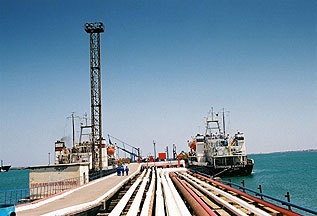
Baku International Marine Trade Port is the largest port on the
Caspian Sea. Its ferry terminal underwent a major reconstruction
supported by a US$16.2 million loan from EBRD. It is now able to
handle 30 million tons of freight a year. The Caspian Sea provides
vital transport links with other countries and is being used to
ship oil until various pipeline projects are completed.
Maritime transport and offshore pipelines
The Azerbaijan State Caspian Marine Company (KASPAR) is a major
ship owning company in the Caspian Basin. It is a diversified
transport organization whose main activity is the transportation of
goods with a predominance of oil and oil products. Navigation
areas: Caspian, Black, Mediterranean and Marmara Seas. Strategies
and priorities for the development of the shipping aim at making
better use of the Eurasian Transport Corridor. The main
production base of the shipping company is a transport fleet
consisting of 70 vessels, 30 of which are 34 tankers (water
carriers), 26 universal cargo ships, and 2 roll on- roll-off and 8
marine rail cargo ferries, with a total deadweight of 316.0
thousand tons.
Today tanker capacity of Azerbaijan estimated 15-20 million tons of
transported oil and oil products per year. The active development
of ferry services on the lines of Baku-Turkmenbashi-Baku,
Baku-Aktau-Baku is being planned.
In September of 2007, the Korean company GSEngineering &
Construction presented to the Ministry of Transport of the final
version of the construction project of a new seaport in Alat.
Moving the seaport from the centre of Baku to Alat settlement
should be realized by 2015. According to preliminary estimates, the
construction of a new seaport would cost more than $ 400
million.
According to the project, the port will have 11 bridges- piers. The
new port built to international standards, will be able to receive
and process 11.6 million tons of cargo in 2015. In light of the
emerging prospects it will be modern gate for access to the Great
Silk Way.
For information on Azerbaijan Port Contact details, please see the following link:
2.1.1 Azerbaijan Baku International Sea Trade Port
Key port information can also be found at: Maritime Database Information on Baku International Sea Port
Port Overview
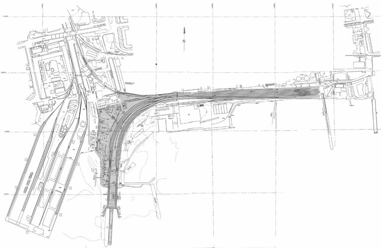
The Caspian sea fleet plays an important role in transport , but changes in trade and declining production have led to a substantial fall in volume transported . Lying between the black sea and central Asia , Baku is a main international port on the Caspian sea which is seen as a strategic part of Azerbaijan's logistics infrastructure and a key point in the whole logistics corridor through which mineral, commodity and other products pass from central Asia to western markets . The port is assessed throughout the year and is not affected by weather conditions. It has seven quays equipped with 27 cranes hoisting capacity of which ranges from 5 to 40 tons . The port is directly linked to the Azerbaijan rail network through ten rail-sidings . There are mainly two different routes available to move cargoes via Baku port :
- Via Volga-Don waterway , this route is limited to seven months per year ( summer ). The loading of the vessels is limited to a maximum draft restriction of 7 m which permits the vessels with up to 5000 MT capacity to berth .
- During the remaining months the cargo traffic functions within the Caspian sea basin with ports of Makhachkala and Guryev ( Russia ) , Bender -Anzali ( Iran ) , Aktau ( Kazakhstan ) and Turkmenbashi ( Turkmenistan )
It has to be noted that Baku international sea port located
currently in the centre of city will be located very soon to the
area which is 60 KM north of Baku ( Alyat settlement ) .
Since May 1995, Azerbaijan has been a member of the International
Maritime Organization ( IMO ) and has ratified six conventions of
IMO. Azerbaijan entered into numerous intergovernmental agreements
with neighboring countries with respect to maritime transportation
within the Caspian basin .
Baku International Sea Trade Port was founded in 1902 and since it
has always been the largest and the most important of Caspian Sea
ports. The port has been constantly developing over the century and
now plays an important role in trans - Caspian trade and is the
main marine gateway to Azerbaijan. The port operates year-round and
as a vital transit point in Europe-Asia trade that is being
promoted within TRACECA - RESTORATION OF THE HISTORIC SILK ROUTE
project. From April to November when Russian inner waterways
are navigable Baku International Sea Trade Port is accessible by
ships loading cargoes for direct voyages from West European and
Mediterranean ports.
With the dramatic increase in trans-Caspian oil trade volumes and
enormous import to Azerbaijan various equipment for offshore oil
activities over last decade the port has further strengthened its
importance. Due to its modern facilities and year-round
accessibility the port maintains its competitiveness and is widely
used by international traders.
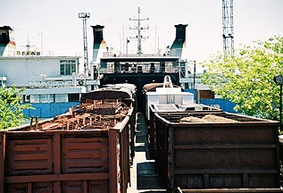
Services rendered to the users of the port include
- Dry cargo and liquid bulk handling
- General and project cargoes
- Container handler (stuffing/stripping)
- Warehousing and storage
- The Baku International Sea Trade Port is comprised of Main Cargo Terminal, Dubendy Oil Terminal, Ferry Terminal and Passenger Terminal. The port`s throughput capacity has been constantly growing and reaches up to 15 million tons of liquid bulk and up to 10 million tons of dry cargoes.
Port website: Baku International Sea Trade Port
|
Port Location and Contacts |
|
|---|---|
|
Country |
Azerbaijan |
|
Province or District |
Baku |
|
Town or City (Closest location) with Distance (km) |
Name: Sumgait km: n/a |
|
Port's Complete Name |
Azerbaijan Baku International Sea Trade Port |
|
Latitude |
40.2343 |
|
Longitude |
49.5256 |
|
Managing Company or Port Authority (If more than one operator, break down by area of operation) |
Baku International Sea Trade Port Authority |
|
Management Contact Person |
n/a |
|
Closest Airport and Frequent Airlines to / from International Destinations |
Airport Name: n/a Airlines: n/a |
Port Picture
Description and Contacts of Key Companies
For i nformation on Azerbaijan Port of Baku contact details, please see the following link:
4.3 Azerbaijan Port and Waterways Company Contact List
Port Performance
For information on Azerbaijan Port of Baku Port Perfromce details, please see the following documents:
Baku Port Ferry Terminal Information.
Baku Port Main Cargo Terminal Information
Baku Port Oil Terminal Information
Baku Port Performance Information
Baku Port Services and Terminals Information
Baku Port Trade Figures by Terminal Information 2009 - 2010 (2)
Baku Port Trade Figures by Terminal Information 2009 - 2010
Baku Port Trade Figures Information 1970 - 2010
Baku Port Trade Figures Information 2009 - 2010
|
Handling Figures |
Year 2012 |
|---|---|
|
Vessel Calls |
4900 Vessels |
|
Container Traffic (TEUs) |
30.000 TEU |
|
Handling Figures Bulk and Break Bulk |
Year 2012 |
|---|---|
|
Total Cargo Handling (mt) |
9 Million mt |
|
Total Annual Capacity of the Port |
18 Million Tons (2010) |
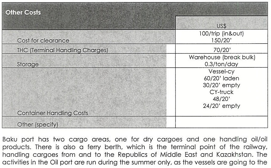
Discharge Rates and Terminal Handling Charges
Discharge Rates ( MT/Day )]
To Warehouse-
Bulk: 4000 - 5000
Bagged: 1000
To Trucks -
Bulk: 4000 - 5000
Bagged: 1000
To Rail Wagons:
Bulk: 1000 - 1500
Bagged: 1000
In theory , The total capacity that can be handled by Baku sea port is 5 Million tons of general cargo and 20 million tons of oil/oil products a year ( this figure was being used at the ex-USSR times ). Five warehouses ( two of metal and three of stone structure) are available with total capacity of 4000 MT.The average discharge rate for bagged cargoes is 1000 MT and for bulk cargoes is 5000 MT a day . Currently all the port cargoes is 1000 MT and for bulk cargoes is 5000 MT a day . Currently all the port facilities are underutilized due to the problems all ex-Soviet union republics are facing .
Berthing Specifications
|
Type of Berth |
Quantity |
Length (m) |
Maximum Draft (m) |
|---|---|---|---|
|
Conventional Berth |
n/a | n/a | n/a |
|
Container Berth |
15000 Container / Year | 866 MTRS |
7 MTRS |
|
Silo Berth |
n/a | n/a | n/a |
|
Berthing Tugs |
6 | ||
|
Water Barges |
2 |
NOTE:
Pilot Boats - 2
Anti-Pollution Boats - 2
Speed Boats - 4
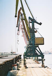
Port Handling Equipment
Is the port equipment managed by the government or privately? n/a
The Main Cargo Terminal is located within Baku city limits is
used for handling general, containerized as well as bulk
export/import and transit cargoes.
While steel products, machinery, equipment and bulk cargoes are
dominant export/import types of goods, general cargoes are mainly
transiting through the port. At the terminal it is possible to
handle up to 2 mln. tons of general and dry bulk cargo per
annum.
Terminal accommodates 6 berths of total length of 866 meters, one
of which function as a RO-RO quay. Depths at the quayside is 7
meters.
Berths are equipped with 16 portal cranes with lifting capacity
from 5 to 40 tons. Forklift trucks with a capacity from 105 to 10
tons, 100 rolltraylers and portal haulers of SI-SU type are also
available. 3 vessels, up to 150 wagons and 100 trucks can be
handled simultaneously during a day. Total length of stub railways
is 8 kilometers. Maneuvering are carried out by 4 diesel
locomotives.
Terminal is equipped with the railroad and truck scales for
weighing cargoes. Total area of the open warehouses is about 24 000
square meters, and that of the sheltered warehouses is about 10 000
square meters.
|
Equipment |
Available (Yes / No) |
Total Quantity and Capacity Available |
Comments on Current Condition and Actual Usage |
|---|---|---|---|
| Rolltraylers and portal haulers of SI-SU type | Yes | 100 | n/a |
|
Dockside Crane - Portal Electric |
Yes |
16 |
5 to 40 tons |
|
Container Gantries |
n/a |
n/a |
n/a |
|
Mobile Cranes |
n/a |
n/a |
n/a |
|
Reachstacker |
n/a |
n/a |
n/a |
|
RoRo Tugmaster (w/ Trailer) |
n/a |
n/a |
n/a |
|
Grain Elevator w/ Bagging Machines |
n/a |
n/a |
n/a |
|
Transtrainer |
n/a |
n/a |
n/a |
|
Forklifts |
Yes |
n/a |
105 to 10 tons |
| Diesel locomotives | Yes | 4 | n/a |
Container Facilities

The main cargo terminal in the Port of Baku serves vessels
carrying containers and bulk and general cargoes. The largest share
of goods is in general cargo, and the Port of Baku's main cargo
terminal has capacity to handle two million tons of general and dry
bulk cargoes per year. The terminal contains six berths totaling
866 meters in length with alongside depth of seven meters. One of
the berths is the Port of Baku's roll-on/roll-off quay. The berths
are fully equipped with 16 cranes to handle up to three vessels at
one time, and they are served by eight kilometers of railway. The
main cargo terminal offers 24 thousand square meters of open
storage and about 10 thousand square meters of covered warehouse
.
Container Terminal is located on the territory of the Main Cargo
Terminal area and is designed for handling of all kinds of
containers, including 40 FEUs and capable of handling of 15000
containers annually. The area of warehouses at the Terminal extends
up to 1600 sq. meters.
The control of the Container Terminal operation is supported by the
computerized system using modern software which meets the
requirements of the international standards.
The Terminal is equipped with the modern cargo handling facilities,
such as Kalmar container forklift with lifting capacity of 42 t and
Kalmar reach stacker with lifting capacity of 40 t, 2 Terberg
terminal tractors, 6 Planmarine trailers, 3 Hyster small
forklifts.
The railway branch line is linked to the Main Railway System, which
provides the intermodal transportation
|
Facilities |
20 ft |
40 ft |
|---|---|---|
|
Container Facilities Available |
Yes |
Yes |
|
Container Freight Station (CFS) |
Yes | Yes |
|
Refrigerated Container Stations |
Yes | Yes |
|
Other Capacity Details |
||
|
Daily Take Off Capacity (Containers per day) |
n/a | |
|
Number of Reefer Stations (connection points) |
n/a | |
|
Emergency Take-off Capacity (Give an indication) |
n/a | |
|
Off take capacity of gang shift (in Containers per shift) |
n/a | n/a |
Customs Guidance
For information on Azerbaijan Customs Guidance, please see the following links:
4.3 Azerbaijan Port and Waterways Company Contact List
1.3 Azerbaijan Customs Information
Terminal Information
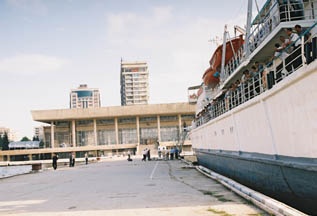
Multipurpose Terminal
The Passenger Terminal with 340 m berth length is used by
foreign and local passenger ships cruising between ports of Caspian
countries. The building of the Sea Station that is being
refurbished will by equipped with the most modern facilities to
ensure comfortable stay of passengers.
The Passenger Terminal is also used by passenger ships carrying oil
workers every day to Oily Rocks.
Oil Handling Terminal
Oil Terminal in Dubendi is the largest terminal at the Apsheron
peninsula. Kazakhstan, Turkmenistan and Azerbaijan oil is handled
at the terminal and further trans-shipped to the ports on the Black
Sea and to the world markets. Terminal includes 2 piers at which 4
tankers with lifting capacities from 5000 to 13000 tons can by
handled simultaneously. Up to 15 million tons of cargoes can by
handled per annum at the terminal.
Upon completion of Baku - Tbilisi -Jeyhan oil pipeline construction
that is being carried out within the framework of `Contract of the
Century` significant volumes of oil from abroad is expected to by
delivered to Baku for further transfer to international markets.
Dramatic increase in transit oil calls of upgrade of existing oil
terminal facilities.
There is Vessels Traffic Service operating at the Terminal. It is
responsible for safe navigation in the water area. Vessels Traffic
Service is equipped with contemporary radio navigation hardware,
which provides navigation of ships round-the-clock. Two tugboats,
one of 600 and other of 1600 horse power, fulfill operations on
safe mooring of vessels.
Terminal is furnished with modern reception facilities for
contaminated waters and means for combating environmental pollution
and accidental oil discharge. Two skimmers keep
round-the-clock watch within the harbour.
Main Silo Terminal
Ferry Terminal is used for transshipment of wagons, trucks and
cars as well as embarkation / disembarkation of passengers to/from
ferries shuttling between Baku / Turkmenbashi / Aktau / Iranian
ports. The shuttle service is carried out by Azerbaijan State
Caspian Shipping Company owned ferries. Each ferry can
simultaneously take on its board 28 wagons or 40 trailers, 202
passengers and up to 50 cars. At the terminal it is possible to
transship up to 8 mln. tons of cargoes per annum.
The ferry terminal that constitutes a vital link between Europe and
Asia plays an important role withinTRACECA-RESTORATION OF THE
HISTORIC SILK ROUTE project. In view of the permanent upward trend
in cargo traffic experienced throughout last years, especially in
Europe -Asia direction, significant rise in ferry terminal
throughput can be anticipated over forthcoming years.
Main Storage Terminal
The port area has 10,000 square meters of covered storage and 28,700 square meters of open storage

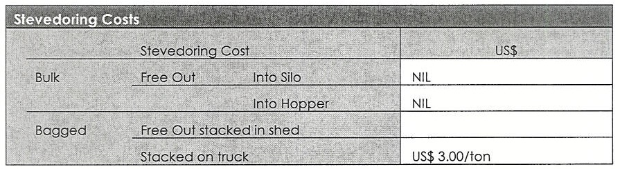
Stevedoring
Port Security
|
Security |
||
|---|---|---|
|
ISPS Compliant (Yes / No) |
n/a |
|
|
Current ISPS Level |
n/a |
Level 1 = Normal, Level 2 = Heightened, Level 3 = Exceptional |
|
Police Boats |
2 | |
|
Fire Engines |
n/a |
2.2 Azerbaijan Aviation
Azerbaijan Aviation

Key airport information may also be found at: World Aero Data Information on Azerbaijan
In 1923, Azerbaijan established the Transcaucasian Civil
Aviation Joint Stock Company “ZAKAVIA”, and on June 2, 1938, the
first air group was established in Azerbaijan. This date in 2006,
was declared Day of Civil Aviation of Azerbaijan according to
relevant decree of the President of the Republic of Azerbaijan
Ilham Aliyev.
Today eleven regions of the country are connected by air with Baku.
Over the past 20 years in the country's civil aviation has been
invested over 200 million USD. This allowed to provide its fleet
with modern aircrafts «Boeing-757”, to modernize air navigation
system, to establish the system of training for twenty respective
specialties, built in Baku and put into commission a modern
international airport serving the aircrafts of more than sixty
airlines. Currently airports awarded international status have
built in five regional centres of the country.
In Baku Cargo Terminal (BCT) which was completed in 2005, and
operating as a transit point, has been provided with all the
conditions for the receipt of goods shipped from west to east and
from north to south. State organization in the management and
regulation of civil aviation is the Civil Aviation Administration
of Azerbaijan.
Civil Aviation:
State Civil Aviation of Republic of Azerbaijan was established
by the Decree № 512 of the President of the Republic Azerbaijan
dated 29 December 2006 and is the central executive body,
exercising control, state policy and regulation in the sphere of
civil aviation. The total number of employees of the Administration
is determined as 49 persons. Expenditures for maintenance and
activities of the Administration are financed from the state budget
of the Republic of Azerbaijan.
The Administration is headed by a director appointed and dismissed
by the President of the Republic of Azerbaijan. Two Deputy
Directors carry out their duties and have personal responsibility.
From 2008 to 2013 Mr. Arif Mammadov successfully directed the
activities of the Administration. Director of the State Civil
Aviation Administration of the Republic of Azerbaijan from February
13, 2013 is Mr. Fuad Guliyev.
The administration consists of five departments:
- Flight Safety Oversight Department;
- Aviation Security Department;
- Licensing and State Registry Department;
- Foreign Relations Department;
- Financial and Economic Department.
For information on Azerbaijan Civil Aviation, please see the following documents:
Azerbaijan Civil Aviation Board Information
Azerbaijan Civil Aviation Board Structure
For information on Azerbaijan Aviation contact details, please see the following link:
2.2.1 Azerbaijan Baku Heydar Aliyev International Airport
Azerbaijan Baku Heydar Aliyev International Airport
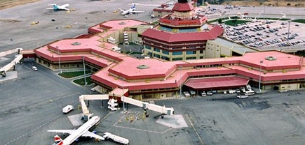
Baku Heydar Aliyev international airport is one of the five
international airports serving Azerbaijan.It serves approximately
1M of passengers a year. Its previous name was Bina international
airport, named after a settlement near Baku. On 10 March 2004, it
was renamed after Azerbaijan's nationwide leader Heydar Aliyev.
The airport is located 20 km northeast of the capital Baku and is
linked to the city by two modern highways commissioned in 2008 and
2009.
It is the base hub of the Azerbaijan Hava Yollari national flag
carrier.
Baku Heydar Aliyev international airport complies with
international requirements. Due to its favorable geographical
location, it has become a first-choice regional airport for
transfer flights between East and West, North and South.
| Location Details | |||
|---|---|---|---|
| Country | Azerbaijan | Latitude |
40.462486 |
| Province / District | Baku | Longitude | 50.05039 |
| Town or City (Closest) |
16mls/25kms East of Baku
|
Elevation (ft and m) | 10 ft / 3 m |
| Airfield Name | Heydar Aliyev International Airport | IATA and ICAO Codes | IATA: GYD, ICAO: UBBB |
| Open From (hours) | 24hrs | Open To (hours) | 24hrs |

Runways
For more information on Runway 16, please see the following document:
|
Runway #16 |
|
|---|---|
|
Runway Dimensions |
2700m x 60m |
|
Orientation |
160 South |
|
Surface |
ASPHALT |
For more information on Runway 34, please see the following document:
|
Runway #34 |
|
|---|---|
|
Runway Dimensions |
2700m x 60m |
|
Orientation |
340 North |
|
Surface |
ASPHALT |
For more information on Runway 18, please see the following document:
|
Runway #18 |
|
|---|---|
|
Runway Dimensions |
3200m x 51m |
|
Orientation |
180 South |
|
Surface |
CONCRETE & ASPHALT |
For more information on Runway 36 , please see the following document:
|
Runway #36 |
|
|---|---|
|
Runway Dimensions |
3200m (Useable length 3065 m) x 51m |
|
Orientation |
360 North |
|
Surface |
CONCRETE & ASPHALT |
Helicopter Pad(s)
|
Helipad #1 |
|
|---|---|
|
Present (Yes / No) |
Yes |
|
Largest helicopter that can land |
Military MI-26 , Superpuma , Dolphin |
|
Width and Length (metres) |
n/a |
|
Surface |
n/a |
Airport Infrastructure Details
|
Customs |
Yes |
JET A-1 fuel |
Yes |
|---|---|---|---|
|
Immigration |
Yes |
AVGAS 100 |
Yes |
|
Terminal Building |
Yes |
Single Point Refueling |
Yes |
|
Passenger Terminal |
Yes |
Air Starter Units |
Yes |
|
Cargo terminal |
Yes |
Ground Power (mobile) |
Yes |
|
Pax transport to airfield |
Yes |
Ground Handling Services |
Yes |
|
Control Tower |
Yes |
Latrine Servicing |
Yes |
|
Weather Facilities |
Yes |
Fire Fighting Category (ICAO) |
Yes |
|
Catering Services |
Yes |
De-icing Equipment |
Yes |
|
Base Operating Room |
Yes |
Parking Ramp Lighting |
Yes |
|
Airport Radar |
Yes |
Approach & Runway Lights |
Yes |
|
NDB |
Yes |
VOR |
Yes |
|
ILS |
Yes |
|
Airport Operating Details
| Operating Details | |||
|---|---|---|---|
| Maximum sized aircraft which can be offloaded on bulk cargo: | IL76 | ||
| Maximum sized aircraft that can be offloaded on pallet | B767 | ||
| Total aircraft parking area (m²) | 15 aircraft parking | ||
| Storage Area (mt) | 3000 SQM | Cubic Meters (m³) | n/a |
| Cargo Handling Equipment Available (Yes / No) | yes | If "Yes" specify below | |
| Elevators / Hi Loaders (Yes / No) | n/a | Max Capacity (mt) | n/a |
| Can elevators / hi loaders reach the upper level of a B747 (Yes / No) | n/a | ||
| Loading Ramps (Yes / No) |
|
||
Storage Facilities
Cargo Facilities : Capacity 3500 Tons
Passenger facilities : 50 Checks in desks , 8 gates , 4 air bridges
, 3 baggage claim belts , post office , bank , exchange ,
restaurants , cafes , VIP and CIP lounges , duty free shop , car
rental , taxi service , first aid , business center
Security
Level: Good
Companies Available
For information on Azerbaijan Aviation Contact details, please see the following link:
4.4 Azerbaijan Airport Company Contact List
Information on some aviation service providers can be found at: AZ Freight Website Information on Azerbaijan Aviation
2.3 Azerbaijan Road Network
Azerbaijan Road Network
For information on Azerbaijan Road Network Contact Details, please see the following link:
4.1 Azerbaijan Government Contact List
The length of public roads in Azerbaijan is 24 981 km. 191 km of
these complies with 4-band movement of road transport. Total road
density in the country is 288 km/ 1000sq. km.
The road network is securely connected to all the cities, regional
centres, towns, airports, seaports, railway stations, reservations,
resort and tourist recreation areas, as well as border crossings
with neighboring countries.
Main roads along which the interstate flow of vehicles with cargo
and passengers is the Baku-Alat-Ganja-Gazakh-Georgian border
(Azerbaijani segment of TRACECA corridor), 503 km long border with
Russia, and the Baku-Astara-border of the Islamic Republic of Iran
( Azerbaijani segment of “North-South” corridor), with length of
521 km.
Road transport in Azerbaijan has been fully privatized.
Transportation of passengers and goods are engaged mainly by the
corporate enterprises and the private sector (companies and
physical persons).
International transport of goods in the Republic of Azerbaijan and
the transit through its territory to other countries make truckers
of 40 countries of Europe and Asia. Azerbaijan has a passenger bus
service to the cities of the Russian Federation, Georgia, Turkey
and the Islamic Republic of Iran.
International passenger traffic carried by the Baku International
bus station complex, located at the entrance to the capital. The
rates, as well as the schedule of long-distance and international
routes can be found at the official website Baku International Bus Information Website

Distance Matrix
For information on Azerbaijan Road Network Distances, please see the following document:
| Baku | Ganca | Sabirabad | Qubadli | |
|---|---|---|---|---|
| Baku | - | 299.27 KM | 145.51 km | 350.85 km |
| Ganca | 229.27 | - | 223.5 km | 172.55 km |
| Sabirabad | 145.51 KM | 223.5 km | - | 205.54 km |
| Qubadli | 350.85 km | 172.55 km | 205.54 km | - |
Road Class and Surface Conditions
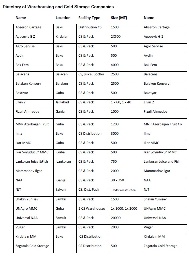
2006 assessment revealed that approximately 70% of Azerbaijan’s roads and highways were in poor condition and required urgent maintenance. Since then the State Program for Rehabilitation and Development of Azerbaijan Republic's Road Networks(2006‐2015) has acted as a road map for addressing these pressing needs. It envisioned a two‐phase rehabilitation of the national road and highway network: Phase 1 (2006‐2009) and Phase 2 (2010‐2015). According to this program, by 2015, Azerbaijan will have repaired and constructed more than 9,500 km of new highways, including 3,578 km of national roads and 5,928 km of local roads. As a result of increased government and international investment in infrastructure projects more than 5,500 km of roads and highways have been rehabilitated. Approximately 806 km of these new roads and highways are of national and international importance. International organizations sponsored 460 km of these highways, while 345 km was financed by the State budget. Currently, construction and rehabilitation work is being continued over 870‐km long parts of the national highways, including 749 km which is financed by international loans. The construction of the country’s international highways and roads along the East‐West and North‐South axes will be completed to international standards by the end of 2012 .
The following table lists the lengths of the main highways in Azerbaijan, and the sections that still require rehabilitation. Along the NSTC route from the Azerbaijan‐Russia border to the Azerbaijan‐Iran border, for example, 53% of roads need to be modernized. The construction work on the northern segment oftheNSTC route (M1) fromBaku to Yalama (Azerbaijan‐Russian border) has completed on 2011, which willreduce transportation time and shorten the distance between Baku and the border by 10 km. The upgrading of the southern segment of the NSTC route from Alyatto Astara (Azerbaijan‐Iran border) (M3) began in 2006 and is expected to be completed in 2013. The M3 is a four‐lane highway that linksIranian and Azerbaijani roads. In the East‐West direction, the main focus is on the 503km long M2 road between Baku and the Red Bridge (Azerbaijan‐Georgia border). The construction work is currently underway on a 171 km segment of M2.
For additional information on Azerbaijan Road Network, please see the following documents:
Azerbaijan Transport Corridors
Main Roads and Roads Under Rehabilitation
2.4 Azerbaijan Railway Assessment
Azerbaijan Railway Assessment

Azerbaijan State Railway (ASR) was established in 1880.
Currently, the total length of railways in Azerbaijan is 2944 km,
the length of operating railways - 2122 km, including 815 km -
double track line. According to the “Program of Azerbaijan
Railway for 2008-2011” the works on the design of high-speed
railway line Baku-Georgian border with 503 km length, which is the
central segment of TRACECA, have been implemented.
Particular importance is the construction of new railway section on
the Baku-Tbilisi-Kars railway, 100 km, and the rehabilitation of
the railway infrastructure of the Baku-Tbilisi-border with Turkey
which will connect by rail area of Middle and Central Asia, through
Azerbaijan, Georgia and Turkey with Europe. Trains which will come
from China and Kazakhstan through Central Asia, the Caspian region,
Baku and Tbilisi will be able to get to Istanbul, and then continue
through the tunnel under the Bosporus to proceed to Europe.
Railway Companies and Consortia
For information on Azerbaijan Railway contact details, please see the following links:
Azerbaijan Minitary of Transport
4.5 Azerbaijan Railway Company Contact List
Key Route Information
For information on Azerbaijan Railway Key Routes, please see the following document:
Key Stations
Baku Railway Station
The complex of buildings of Baku railway station consists of an old
Tiflis station, built in 1884, the new building of the
Baku-Passenger Station (60-70s of XX century) and Sabunchu station
(1924), specially built for the USSR's first electric trains which
had to carry the workers to the oil fields of Absheron
(Baku-Sabunchi).
Station complex is in the centre of town, next to 28th May
underground. International passenger traffic on the
Baku-Moscow-Baku, Baku-Astrakhan-Baku, Baku-Makhachkala-Baku,
Baku-Rostov-Baku, Baku-Tbilisi-Baku, Baku-Kharkov-Baku,
Baku-Odessa-Baku, Baku -Tyumen-Baku, Baku-Novosibirsk-Baku routes
is realized from here. Trains also make trips to Ganja, and
electric trains to Sumgait city, Hovsan and Mardakan
settlements.
Azerbaijan State Conservatory named after U.Hajibeyov, the National
Bank of Azerbaijan, Heydar Aliyev Palace are situated some distance
far from the station complex.
Note that the realization of the tickets at the box office of the
Baku railway station is also carried out through POS-terminals
which allow the passengers to use bank cards such as Visa and
MasterCard in case of payment.
For information on Azerbaijan Railway construction and maintenance, please see the following documents:
2.5 Azerbaijan Storage Assessment
Azerbaijan Storage Assessment
For information on Azerbaijan Storage contact details, please see the following link:
4.6 Azerbaijan Storage and Milling Company Contact List
Commercial Storage
|
Location |
Owner |
Available for Rent |
Capacity mt / m² / m³ |
Type [1] |
Access [2] |
Condition [3] |
|---|---|---|---|---|---|---|
| Mingechevir | State property committe | - | 3500 Tons | Fair |
Good |
[1] Warehouse Type: Open storage, container, rub-hall, silo, concrete, other, unspecified
[2] Warehouse Access: Raised-siding, flat
[3] Warehouse condition: Appears intact, appears damaged, under construction/repair
Cold Chain
2.6 Azerbaijan Waterways Assessment
Azerbaijan Waterways Assessment

There is no Navigational Rivers in Azerbaijan.
2.7 Azerbaijan Milling Assessment
Azerbaijan Milling Assessment
Food prices on some food products increased on a yearly
basis
In Azerbaijan, a decline in wheat flour and bread prices was
observed in August, which reflects the good 2012 harvest. However,
wheat flour prices strengthened in October, although they remained
at about the same level till the end of 2012 due to improved
domestic supplies from the bumper harvest. However, mutton and beef
prices increased by 12 and 6 percent respectively compared to the
same period of last year. Since the share of household expenditure
on food is significant, any increase in food prices puts vulnerable
population groups at risk of food insecurity
For information on Azerbaijan Milling, please see the following documents:
Azerbaijan Food Production Information
For information on Azerbaijan Milling Companies avaliable, please see the following link: