2 Bangladesh Logistics Infrastructure
Bangladesh Logistics Infrastructure
The following sections contain information regarding the logistics infrastructure of Bangladesh.

2.1 Bangladesh Port Assessment

As a country situated by the sea Bangladesh has a large coastline of 580 km spread across the southern part of the country where it is joined with the Bay of Bengal. The ports situated by the sea have given Bangladesh opening for business, economic growth and a connection with the rest of the world. Although still being a developing country, like most of the developed countries majority of the economy in Bangladesh depends on these seaports, as 90% of the export and import both are conducted through these ports. There are 3 seaports in Bangladesh at present. The largest one Chattogram and second largest Mongla are in full operation. The third in size and capacity Payra port is partially in use. A fourth one named Matarbari seaport is on its way to be opened and become fully functional very soon. It is that to keep a smooth flow of commercial transactions proper development, managing and directing these seaports with utmost efficiency is essential. For this reason, these seaports are directed under Ministry of Shipping in Bangladesh.
A detailed list of the transit times of ocean freight from other ports to the port of Chittagong can be found here:
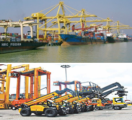
2.1.1 Bangladesh Port of Chittagong
Key port information can also be found at: Maritime Database information on Bangladesh
Port Overview
|
Port Location and Contacts |
|
|---|---|
|
Country |
Bangladesh |
|
Province or District |
Chittagong |
|
Town or City (Closest location) with Distance (km) |
Name: Chittagong km: n/a |
|
Port's Complete Name |
Port of Chittagong |
|
Latitude |
22.21667 |
|
Longitude |
91.8 |
|
Managing Company or Port Authority (If more than one operator, break down by area of operation) |
Chittagong Port Authority (CPA) |
|
Management Contact Person |
Md. Omar Faruk +880-31-2510869 secretary@cpa.gov.bd |
|
Closest Airport and Frequent Airlines to / from International Destinations |
Airport Name: Shah Amanat International Airport Airlines: BIMAN, NovoAir, Regent Airways, US-Bangla Airways |
Port Picture
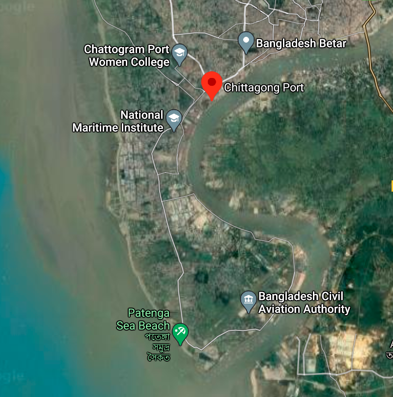
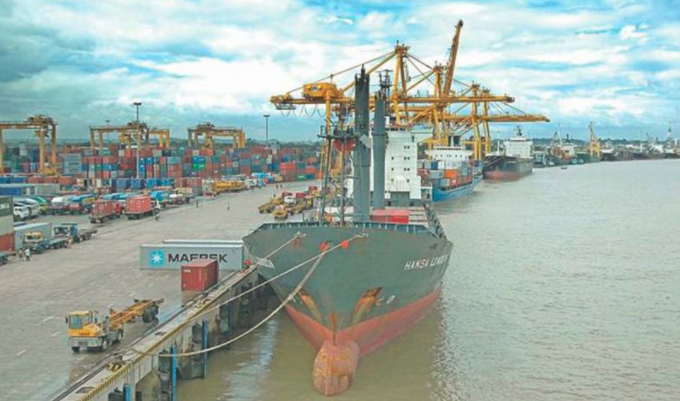
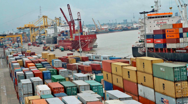
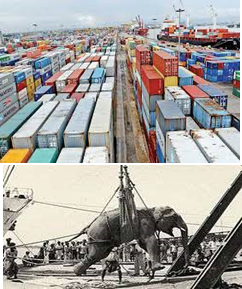
The Port of Chattogram is the principal port of Bangladesh. The port was established at its present location in 1887. By 1910, four jetties were constructed to handle 0.5 million MT of cargo annually. Since then the port has grown gradually to the present shape.
It is situated on the right bank of the river Karnafuli at a distance of about 9 nautical miles from the shoreline of the Bay of Bengal. Chattogram Port is considered the heart of the economy of Bangladesh. The geographic location of this port creates the opportunity for easy and cost-effective foreign trade to be carried out through with all South Asian countries as well as other Asian countries. Enough and low-cost labour is also readily available here. For these reasons, Chattogram Port holds much potential as a highly promising regional seaport. Consequently, cargo handling through Chattogram Port has not only rapidly increased but cargo type has also diversified. The Port is a regular member of Japan based International Ports and Harbours (IAPH).As a gateway of Bangladesh, Chattogram Port not only handles 92% of the country’s international trade but also generates about 35% annual revenue of the country on account of import tax, duties and VAT which confirms the significance of the port in the Government’s finance. About 80% export-import industries and 5-Export Processing Zone (out of 10 EPZ) are situated within Dhaka and Chattogram division and Dhaka- Chattogram corridor (transportation by rail, road & river) due to the Chattogram Port. This also helps to generate about 30% of the GDP. 100% imported Petroleum Oil and Lubricant (POL) of the country is transported through this port. Not only that, through this port 100% finished product are exported and 80% raw materials & accessories are imported. For Ready Made Garments (RMG) sector, which fetches about 76% of the country’s export earnings as hard currency.
Port website: http://cpa.gov.bd/
Key port information may also be found at: http://www.maritime-database.com
It is situated on the right bank of the river Karnafuli at a distance of about 9 nautical miles from the shoreline of the Bay of Bengal. River Karnafuli rising in the Lushai Hill falls in the Bay of Bengal after taking a winding course of 120 nautical miles through the districts of Chattogram Hill Tracts and Chattogram. Upper limits of the river water are formed by two straight lines, one drawn across the Karnafuli River in the North by joining 2 pillars located at Lat: 22024’33″N-Long: 91054’30E and Lat: 22024’56″N- Long: 91054’11″E and the other by joining the 2 pillars located at Lat: 22025’07″N- Long: 91053’18″E and Lat: 22025’07″N- Long: 91053’10″E. These limits include so much of the sea and of the River Karnafuli and the River Halda and the area that lie within 137.162 Metre, of high water mark at ordinary spring tide and the docks, wharves, quays, stages, jetties, piers, warehouse, sheds, railway line and yards within the limits of the bounded area and such other area outside it as included in the Schedule iii of the Chattogram Port Act. The seaward approach to the Port of Chattogram may considered to be northwards of the 10-fathom contour in latitude 22024′ North and longitude 9103″ East: The distance to the pilot ground from the south patches shoal being 46 nautical miles on the direct course.
Port Performance
Chattogram Port is the core hub of export and import of the country. The port has been performing better and better each year despite lots of limitations. It is now competing with the world rated ports in terms of all matrix. This port is now ranked at 64 in the Lloyd’s list of 100 container ports in the world, which was 70th, 71st, 76th and 87th in last 4 years.
Vessels of draught ranges from 8.50 m. to 9.20 m
Maximum permissible LOA of a vessel is 190 meters
|
Seasonal Constraints |
||
|
Occurs |
Time Frame |
|
|
Rainy Season |
Yes |
The weather in Bangladesh is largely governed by the monsoon. The prevailing wind directions are from South to South East during the months of April through September. After taking easterly direction for a while the wind turns to the northerly and north-easterly directions, the later prevail from November to January. During the months of February and March, winds turn via westerly direction back to the Southerly to South Easterly. In excess of 20 Knots/ Beaufort wind scale 5 prevails for 6 percent to time while those in excess of 30 Knots/Beaufort wind scale 7 persists for about 0.1 percent of the time during cyclones i.e. During the transition between monsoon and dry seasons in May, October, and November. The area of Payra port experienced four severe Cyclonic water surges during the last 44 years. In 1960 & 1963 speeds recorded were 125 Knots Max. In 1970 and 1991 speeds were recorded 138 Knots max. and 180 Knots max. respectively. |
|
Financial Year |
No. of Vessels |
|
2012-2013 |
2,136 |
|
2013-2014 |
2,294 |
|
2014-2015 |
2,566 |
|
2015-2016 |
2,875 |
|
2016-2017 |
3,092 |
|
2017-2018 |
3,664 |
|
2018-2019 |
1,882 (till Dec 2018) |
|
Financial Year |
Import (Tons) |
Export (Tons) |
Inland (Tons) |
ICD (Tons) |
Grand Total (Tons) |
Growth (%) |
|
2012-2013 |
38,312,028 |
5,059,640 |
6,087,947 |
457,559 |
49,917,174 |
3.95 |
|
2013-2014 |
41,960,170 |
5,338,377 |
5,833,786 |
445,218 |
53,577,551 |
7.33 |
|
2014-2015 |
48,941,406 |
5,839,986 |
6,469,673 |
474,800 |
61,725,865 |
15.21 |
|
2015-2016 |
58,324,786 |
5,971,634 |
6,366,607 |
493,360 |
71,156,387 |
15.28 |
|
2016-2017 |
66,464,285 |
6,709,759 |
6,330,639 |
477,836 |
79,982,519 |
12.40 |
|
2017-2018 |
78,050,447 |
6,997,465 |
7,429,082 |
446,234 |
92,923,228 |
16.18 |
|
2018-2019 |
82,939,731 |
6,846,406 |
7,761,749 |
515,245 |
98,240,655 |
5.72 |
Container Handling Statistics of CPA
|
Financial Year |
Import |
Export |
Total |
|||
|
TEUs |
MT |
TEUs |
MT |
TEUs |
MT |
|
|
2013-14 |
812,918 |
11,125,348 |
812,591 |
5,012,427 |
1,625,509 |
16,137,775 |
|
2014-15 |
940,827 |
13,132,923 |
926,115 |
5,535,446 |
1,867,062 |
18,668,369 |
|
2015-16 |
1,109,355 |
15,498,565 |
1,080,084 |
5,642,419 |
2,189,439 |
21,140,984 |
|
2016-17 |
1,211,874 |
17,084,610 |
1,207,607 |
6,395,923 |
2,419,481 |
23,480,533 |
|
2017-18 |
1,363,375 |
19,089,447 |
1,342,534 |
6,880,740 |
2,705,909 |
25,970,187 |
|
2018-19 (Jul-Dec 18) |
719,433 |
96,74,719 |
725,911 |
33,82,752 |
14,45,344 |
13,057,471 |
Discharge Rates and Terminal Handling Charges
|
Vessels chargeable |
Rate of port dues |
|---|---|
|
Sea-going vessels |
USD 0.241 per GRT |
|
Sea-going vessel engaged in lightering within port limits |
USD 0.150 per GRT |
|
Sea-going vessels not engaged in lightering have not left the port after 30 days from the date of entry |
USD 0.050 |
|
Sea-going vessel entering for taking fuel, stores and water, etc |
USD 0.08 |
|
Vessels working within port limits, excluding sea-going lighters |
Not exceeding 10 GRT: 25 BDT per vessel Between 10 – 100 GRT: 200 BDT Between 100 - 200 GRT: 500 BDT Exceeding 200 GRT: 3 BDT per GRT Barge/flat: 1.5 BDT per GRT Country boat/Shampan: 0.25 per GRT. |
Other Charges
|
Berth occupancy charges |
Per GRT per day |
USD 0.03 |
|
|---|---|---|---|
|
Mooring occupancy charge |
At Own anchor |
Per GRT per day |
USD 0.02 |
|
At mooring |
Per GRT per day |
USD 0.015 |
|
|
Sea-going ships |
200 to 1,000 GRT |
Per Tug per Movement |
USD 82.50 |
|
Over 1,000 to 5,000 GRT |
Do |
USD 277.50 |
|
|
Over 5,000 GRT |
Do |
USD 594 |
|
|
Water supply charge |
At Roosevelt jetty |
Per 1000 liters |
30BDT |
|
At Mongla (local) At Mongla (to Ships) |
Per 1000 liters Per 1000 liters |
60 BDT USD 10 |
|
|
At Hiron pont (local) |
Per 1000 liters |
700BDT |
|
|
At Hiron pint (to ship) |
Per 1000 liters |
USD 20 |
|
|
Jetty Crane Charge |
Use of Jetty crane |
Per crane per period of 8 hours |
USD 45 |
|
Use of British crane |
Do |
USD 33.75 |
|
|
Non-Use of Jetty Crane |
If cancelled within less than 6 hours of booked period |
Do |
USD 40 |
|
If cancelled previous to 6 hours of booked period |
Do |
USD 20 |
|
|
Holliday charge (working on jetty) |
Per ship per holiday |
USD 60 |
|
|
Night charge (working on jetty) |
Per ship per night |
USD 30 |
|
|
Security guard engaged on the sea-going vessel |
Per person, per 4 hours |
BDT 150 |
|
Shifting / Detention Fees
|
Services |
Basis of Charge |
Rate |
|---|---|---|
|
Fees for shifting vessels from one berth or mooring or swinging her to another |
Per movement |
USD 29.80 |
|
Fees for such shifting taking place in whole or part between 6:00 pm to 6:00 am |
Per movement |
USD 59.60 |
|
Detention fees for failure of a vessel in arriving or sailing from the port in time |
Per day |
USD 100 |
|
Pilot detention fee |
Per day |
USD 20 |
|
Berthing or unberthing at the time of arrival or sailing of the vessels |
Each occasion |
USD 88.50 |
|
Same at the time of shifting |
Each occasion |
USD 44.25 |
Port & Harbour Dues
|
Services |
Basis of Charge |
Rate |
|
|---|---|---|---|
|
River dues |
Domestic cargo |
Per 1000 kg |
33BDT |
|
Import cargo |
Do |
BDT 15.30 |
|
|
Landing charge / Handling charge |
Bagged cargo (wheat and rice) |
Per 1000kg |
BDT. 40 |
|
Other bagged cargo (cement, iron, steel, salt, sugar etc) |
Do |
BDT. 32 |
|
|
All other imports not exceeding 3MT |
Do |
BDT. 90 |
|
|
Wheeled or tracked equip. |
Do |
BDT 175 |
|
|
Garments, cloths, cotton, etc |
Do |
BDT. 16 |
|
|
Crude refined oil, palm oil, soyabean oil etc |
Do |
BDT. 50 |
|
|
Other import more than 20 MT |
Do |
BDT. 250 |
|
|
Weight bridge charge |
Per 1000 Kg |
2.5BDT |
|
|
Trans-shipment charge at the same wharf |
Per 1000 Kg |
150% of landing charge |
|
|
Terminal charge on river traffic |
Per 1000 Kg |
21.70BDT |
|
Container Handling Charges
|
Services |
Time |
Basis of charge |
Up to 20’ Container |
Above 20’ container |
|
|---|---|---|---|---|---|
|
Loading / Discharging |
FCL Container |
- |
Per container |
USD 43.40 |
USD 65.10 |
|
LCL Container |
- |
Do |
USD 130.00 |
USD 195.00 |
|
|
Empty Container |
- |
Do |
USD 22.10 |
USD 33.20 |
|
|
Container storage |
Loaded Container |
1-4 days free |
Per container |
- |
- |
|
1st 7 days after free time |
Do |
USD 6.00 |
USD 12.00 |
||
|
8th -20th days |
Do |
USD 12 |
USD 24 |
||
|
Thereafter up to delivery |
Do |
USD 240 |
USD 48 |
||
|
Empty Container |
1-7 daus days |
Per container |
USD 6.00 |
USD 12.00 |
|
|
8-20 days |
Do |
USD 1200 |
USD 24.00 |
||
|
21 days onwards/per day |
Do |
USD 24.00 |
USD 48.00 |
||
Reefer Container Service
| Particulars of Charges | Basis of Charge | Rates |
|---|---|---|
| Supply of electricity and connecting and disconnecting reefers, including monitoring |
Per container, per diem or part thereof |
USD 9.00 |
| Change of status |
Per container per change |
USD 10.00 |
River Dues (Containerized)
|
Particulars of Charges |
Basis of Charges |
Rates (Not Exceeding 21 ft.) |
Rates (Exceeding 21 ft.) |
|---|---|---|---|
|
FCL container and Contents |
|||
|
Import |
Per container |
BDT. 408.00 |
BDT. 816.00 |
|
Export |
Do |
BDT. 184.00 |
BDT. 368.00 |
|
LCL container and Contents |
|||
|
Import |
Per 1000 kg. or part thereof |
BDT. 34.10 |
- |
|
Export |
Do |
BDT. 15.30 |
- |
Lift on / Lift off Charges
|
Lift on / lift off charge, Loaded container |
per container |
BDT. 1000.00 |
BDT. 1500.00 |
|---|---|---|---|
|
Lift on / lift off charge, empty container |
-do- |
BDT. 375.00 |
BDT. 562.50 |
Shore handling containerised cargo
| Particulars of Charges | Basis of Charges | Rates |
|---|---|---|
| Stuffing / un-stuffing | Per 1000 kg. or part thereof of contents | BDT. 300.00 |
Berthing Specifications
| Specifications | NB | Bulk Min | Bulk Max | Conventional Min | Conventional Max |
|---|---|---|---|---|---|
| Berths |
31 |
2.2 m |
186 m |
2.2 m |
190 m |
| Anchorages | No limit | 8.5 m | 11.5 m |
8.5 m |
11.5 m |
| Draught at anchor | N/A | 8.5 m | 11.5 m |
8.5 m |
11.5 m |
| Draught at Berth | N/A | 8.55 m | 9.2 m |
8.55 m |
9.2 m |
| Length Over All | N/A | No limit | 186 m |
No limitations |
186 m |
| Beam (maximum) | N/A | No limit | No limitations if length is 186 m |
No limitations |
No limitations provided length is 186 m or less |
General Cargo Handling Equipment
|
1 |
Mobile Crane |
10-50 ton |
51 |
|---|---|---|---|
|
2 |
Forklift Truck |
10-20 ton |
15 |
|
3 |
Forklift Truck |
3-5 ton |
130 |
|
4 |
Industrial Tractor |
25 ton |
12 |
|
5 |
Heavy Trailer |
20-25 ton |
07 |
|
6 |
Light Trailer |
6 ton |
30 |
|
7 |
Share Crane |
2-3 ton |
31 |
Container Handling Facilities
|
Facility |
Capacity/Nos |
|
|---|---|---|
|
Holding Capacity (GCB+CCT+NCT+NCY) |
38,917 TEUs |
|
|
Yards |
22 Nos. |
|
|
Container Freight Stations at GCB |
5 Nos (45,064 Sq.m) |
|
|
Container Storage yard at GCB |
282,239 sq.m |
|
|
CFS at CCT |
13,671 sq.m |
|
|
Container Storage yard at CCT |
150,000 sq.m |
|
|
Container Storage yard at NCT |
220,000 sq.m |
|
|
Container Storage yard at NCY |
63,000 sq.m |
|
|
Railway Container Siding |
550 m |
|
|
Reefer Points (440 volts) |
900 points |
|
|
Standby Generator |
14 MW (2X7) |
|
|
Water Reservoir |
140,000 Gallons |
|
|
Fire Brigade |
1 Unit |
Container Handling Equipment
|
Equipment Type |
Capacity (MT) |
Qty |
|
|---|---|---|---|
|
Quay Gantry Crane |
40 |
14 |
|
|
Mobile Harbour Crane |
84 |
2 |
|
|
Rubber Tyred Gantry Crane |
44 |
21 |
|
|
Straddle Carrier (04 High) |
40 |
36 |
|
|
Reach Stacker (RS) |
45 |
15 |
|
|
Forklift Truck |
25-42 |
6 |
|
|
Forklift Truck |
7-16 |
19 |
|
|
Reach Stacker |
7 |
6 |
|
|
Container Mover |
50 |
6 |
|
|
Terminal Tractor |
50 |
43 |
|
|
Terminal Trailer |
50 |
55 |
Container Facilities
|
|
At a time |
Yearly |
|
|---|---|---|---|
|
Container |
6,000 (TEU) |
100000 (TEU) |
6,00,000 (TEU) |
|
Cargo |
60,000 (MT) |
2,00,00,000 (MT) |
4,00,00,000 (MT) |
|
Car |
2,000 |
20,000 |
40,000 |
Customs
Customs clearance process is also mainly paper based and appraisal and verification are done without standardized modern logistics support (container scanner). Procedural complexities, lack of transparency and timeliness in decision-making often caused lot of harassment and delay in the customs clearance process.
Since 2000, ASYCUDA has been introduced without the two main modules EDI and Risk Assessment Management. The customs clearance procedures for import still consist of 13 to 16 steps, a cumbersome, redundant, paper ledger and list-oriented process. In the absence of modern technology in controlling & appraising method, problems of trust arise among the regulatory and trade body.
Food Handling Arrangements
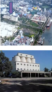
For offloading from ships and safe storage of food grains CPA has dedicated a silo jetty at North Patenga. There is a silo situated adjacent to the jetty. It is one of the biggest silos in Bangladesh with storage capacity of 100,000 mt. It deals with wheat only and is under the administrative control of the Ministry of Food of the Government of Bangladesh. The strategy for Chattogram silo is to use it predominantly for quick clearance of incoming mother vessels carrying imported wheat, for storage of a national buffer stock, to maintain quality of stored grain and quick dispatching to up-country destinations with maximum efficiency.
From an operational point of view, Chattogram silo can be divided into three sub-systems:
- Receiving
- Storage
- Despatching
Receiving Sub-system
This silo has the facilities to receive food grain (particularly wheat) only in bulk through gantry. The objective of the system is as follows:
- To start unloading as quickly as possible.
- To unload grain from carrier within minimum possible time.
- To record the weight of all incoming grain accurately.
- To ensure safe storage.
Storage Sub-system
The Chattogram silo having a capacity of 103,804 MT of bulk wheat, it has 88 round bins and 54-star bins. The capacity of each round bin is 1,000 MT and the star bin is 225 MT. The silo is provided with a dust control machine. Existing fumigation on pest control systems is provided via a liquid spray system and peeled dispenser system, though it is rarely used due to non-infestation of the grain. The objective of this sub-system is to keep the grain in good quality.
Despatching Sub-system
This silo has the facilities to dispatch food grain both in bulk and bagged form. In bulk it is mainly delivered by river coaster in Narayangonj Silo and Khulna Steel Silo and through hopper wagon in Ashugonj, Santaher and Narayangonj Silo. The bagged cargo is delivered mainly through railway covered wagon and through truck in almost all CSD and LSD in the country.
Specification of Chattogram Silo
|
Highest Capacity |
103,804 MT |
|
|---|---|---|
|
Diameter of Circular Bins |
27’-0’’ |
|
|
Height of Bins |
94’-0” |
|
|
No. of Star Bins |
54 (250 MT) |
|
|
No. of Circular Bins |
88 (1,000 MT) |
|
|
Size of head house floor |
34’ x 74’ |
|
|
Height of head house above finished grade |
174’ |
|
|
Height of head house above airport runway |
150’ |
|
|
Depth of head house board pit |
24’ |
|
|
Pneumatic travelling ship unloading unit |
3 (600 MT/hour) |
|
|
Pneumatic static ship |
1 (200 MT/hour) |
|
|
Receiving belt conveyor |
3 (200MT/hour each) |
|
|
Main Bucket elevator |
4 (200MT/hour each) |
|
|
Basement chain conveyor |
8 (200MT/hour each) |
|
|
Automatic hopper scale |
4 (Computerized) |
|
|
Truck scale (Weigh bridge) |
1 (capacity 40 MT) |
|
|
Distribution belt conveyor with tripper |
6 |
|
|
Chemical Protecting sprayer |
6 |
|
|
Sp. Fumigation bins |
2 |
|
|
Grain Drier |
1 |
|
|
Grain cleaner |
1 (25 MT per hour) |
|
|
Bagging scale |
6 (8 bags of 85 kg/ min) |
|
|
Temperature indication system |
1 |
|
|
Truck loading (bag) |
8 |
|
|
Rail loading (bunk) |
2 |
|
|
Jetty length- (a) Unloading / Loading (b) |
328 meters/42 meters |
|
|
Sub station |
3 units (each 1200 KVA) |
Cargo Storage Space (Break-bulk)
|
Protected Area |
Outside Protected Area |
||||
|---|---|---|---|---|---|
|
Transit Sheds (1-9) |
09 |
64364 Sq Mtrs |
Warehouses |
06 |
25179 Sq Mtrs |
|
Warehouses DFPO |
04 |
20712 Sq Mtrs |
Open Dumps |
- |
200,000 Sq Mtrs |
|
Car Sheds (P & F) |
02 |
8696 Sq Mtrs |
|
|
|
|
Open Dumps |
- |
90,000 Sq Mtrs |
|
|
|
|
Note: Food Dept for Grains, TSP complex, Cement Clinker and different Oil company have their own storage facilities adjacent to their own Jetties/premises. |
|||||
Description and Contacts of Key Companies
For information on Bangladesh Port of Chittagong contact details, please see the following link:
4.4 Bangladesh Port and Waterways Company Contact List
For information on Bangladesh Port of Chittagong additional information, please see the following document:
Bangladesh Port of Chittagong Additional Information
Bangladesh Chittagong Port Overview
Bangladesh Port of
Chittagong Port Security
Note: The information provided in the attached documents, which has been taken from the old DLCA, does not match the structure of the new LCA and is therefore provided separately.
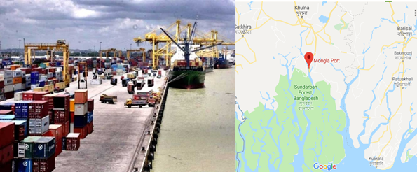
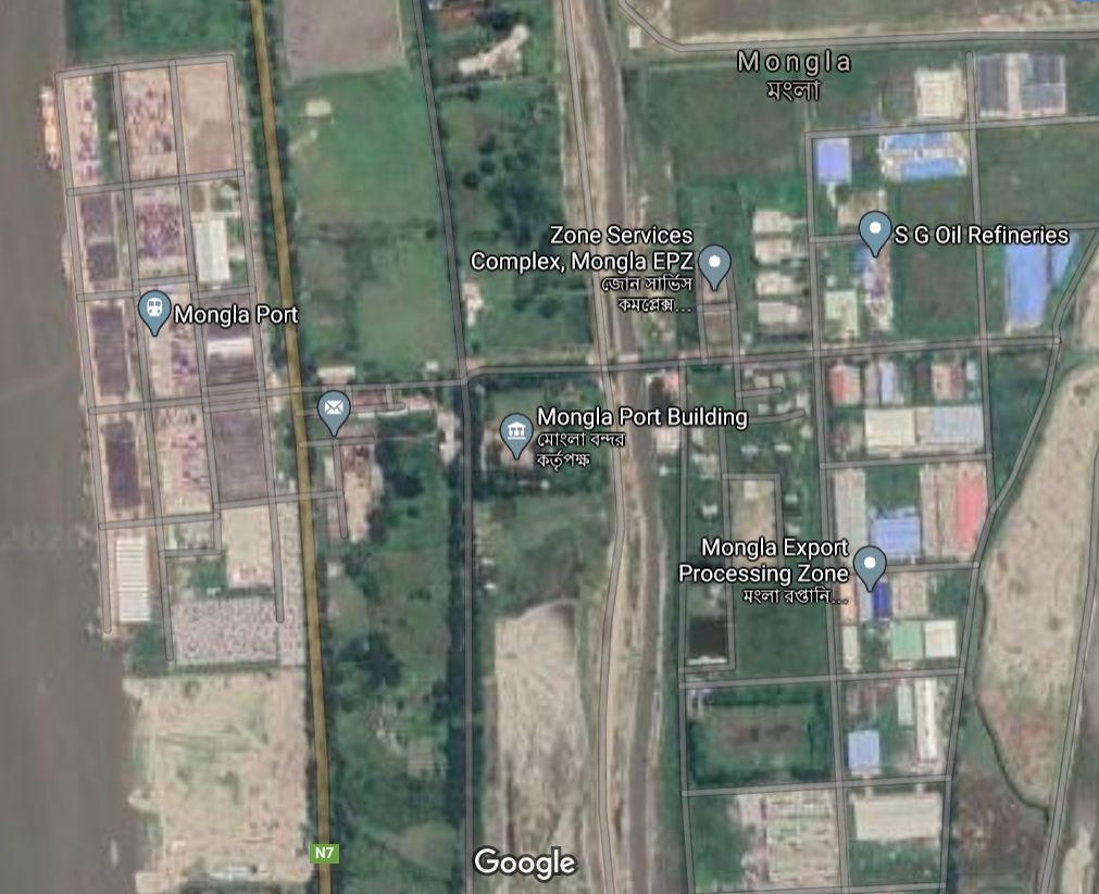
2.1.2 Bangladesh Port of Mongla
Port Overview
Mongla Port Provides facilities and services to the international shipping lines and other concerned agencies providing shore-based facilities like jetties, go downs, cargo handling equipment and maintaining adequate water depth in the channel as well as making provision for safe day and night shipping. Even if, in theory, there should be a ratio of 60 – 40 % between Chattogram and Mongla, the reality so far from that with Chattogram currently totalizing 92% of the country’s international trade.
Vision of MPA
- To Handle annually 1000 ships by 2021.
- To ensure international standard of service to the port users.
- To create congenial atmosphere for flourishing port base industries.
- To Modernize the port in the light of the global trade.
- To create job opportunities and to provide remarkable financial income to the national exchequer.
- To open new commercial windows for sustainable economic development.
Port website: Port of Mongla Website
|
Port Location and Contacts |
|
|---|---|
|
Country |
Bangladesh |
|
Province or District |
Khulna District |
|
Town or City (Closest location) with Distance (km) |
Name: Khulna km: 45 minutes from Kulna |
|
Port's Complete Name |
Port of Mongla |
|
Latitude |
22.48867 |
|
Longitude |
89.59283 |
|
Managing Company or Port Authority (If more than one operator, break down by area of operation) |
Mongla Port Authority |
|
Management Contact Person |
n/a |
|
Closest Airport and Frequent Airlines to / from International Destinations |
Airport Name: n/a Airlines: n/a |
Mongla Port Officer’s Contact List
|
Name & Address |
Designation and email |
Telephone and fax |
|---|---|---|
|
Name: Rear Admiral M Mozammel Haque, (G), NUP, ndc, psc, BN, |
Chairman Email: chairman@mpa.gov.bd |
Phone (office): 04662-75215 Fax: +041662-75224 |
|
Name: Yasmin Afsana |
Desig: Member (Finance) Email: mf@mpa.gov.bd |
Phone (off): 04662-7514 |
|
Name: Md. Altaf Hossain Khan |
Desig: Member (Engineering & Development) Email: med@mpa.gov.bd |
Phone (office): 04662-75333 Fax: 04662-75244 |
|
Name: Captain Mohammed Ali Chowdhury, (C), BCGM, ndc |
Desig: Member (Harbour & Marine) Email: chowali@yahoo.com |
Phone (office): 04662- 75222 Fax: 04662- 75224 |
|
Name: Md. Gias Uddin |
Designation: Director (Admin) Email: da@mpa.gov.bd |
Phone (office): +0466 2-75345 Fax: 04662- 75224 |
|
Name: Commander Sheikh Fakhar Uddin (C) BN |
Designation: Harbour Master Email: hm@mpa.gov.bd |
Phone (office): +04662-75221 |
|
Name: Lt Commander M ABDUL ALIM, (N), BN |
Desig: Chief Security Officer Email: cso@mpa.gov.bd |
Phone (office): +04662-75232 |
|
Name: Mr. Ohiuddin Chowdhury |
Designation: Secretary Email: oc2225@gmail.com |
Phone (office): +04662-75275 |
|
Name: Md. Zahirul Huq |
Designation: Chief Planning Email: cp@mpa.gov.bd |
Phone (office): +04662-75218 |
|
Name: Md. Mostafa Kamal |
Designation: Director (Traffic) Email: kamal6498@yahoo.com |
Phone (office): +04662-75363 |
|
Name: Md. Faruqul Islam |
Desig: Chief Hydrographer Email: faruqulchmpa@gmail.com |
Phone (office): +04662-75312 |
Port Facilities and Infrastructure
|
Total Berths |
Quantity |
Length (m) |
Draft (m) |
|---|---|---|---|
|
General Cargo/ Container Berths |
5 |
max 225 m |
4.5 – 5 m |
|
River Mooring Buoys |
7 |
max 225 m |
3 – 8 m |
|
Anchorage Berths |
14 |
max 225 m |
4.7 – 9 m. |
|
Mongla Cement Factory Jetty (Private) |
1 |
max: 225 m |
6.1m |
|
Meghna Cement Factory Jetty (Private) |
1 |
max: 225 m |
6.5 m |
|
Klean Heat Gaz Factory (Private) |
1 |
max 225 m |
6.0m |
|
Summit United LPG Jetty |
1 |
max 225 m |
1.8m |
|
Summit United Petroleum Jetty |
1 |
max 225 m |
Not available |
|
Dubai-Bangladesh Cement factory Jetty |
1 |
max 225 m |
Not available |
|
Holcim Cement Factory Jetty |
1 |
max 225 m |
Not available |
|
Vessel Concrete Jetty |
1 |
max 225 m |
Not available |
|
Pontoon Berth (for Fresh Water |
1 |
max 225 m |
Not available |
|
Pontoon berth (Inland vessels & Ferry) |
1 |
max 225 m |
Not available |
|
Berthing Tugs & Mooring Boats |
3 |
|
|
|
Pilot Boats |
3 |
||
|
Water Barges (Dumb) |
4 * 500 MT |
||
Port Facilities at a Glance
- The port is surrounded as well as well protected by the mangrove forest Sundarbans and free from all types of congestion of ships and cargo.
- River and road transport facilities available comparatively at lower cost from Mongla port to all over the remote places of the country.
- Constraint free large channel available for anchorage and loading/unloading facilities on both sides for 33 ships at a time.
- Due to construction of Khanjahan Ali as well as Lalonshah bridge, good transport connection system has been developed from Mongla Port to all the hinterland of North Bengal.
- Unique opportunity for Dhaka-Mongla-Dhaka transportation only within 5 hours by Dhaka-Maowa Road, in spite of a ferry service on the way.
- As there is no by-crossing, the goods can be transported easily without any constraint by inland coaster/barge from Mongla port.
- Up to 225-meter-long ship can enter into the port for discharging cargo.
- No constraints in berth and less turn-around time.
- In compare with Chattogram Port, the Landing charge, Shipping charge and River dues are lower in Mongla port.
- 15 days free time available in case of handling empty container (Import).
- The port is open for 24 hours.
- Infrastructural facilities available for storage of both specialized and General cargo.
- Handling & parking facilities of motor vehicles available.
Port Performance and Capacity
Port performance in last 3 Years
| Performance Type | Export/ Import | FY 2016 - 17 | FY 2017 - 18 | FY 2018 - 19 |
|---|---|---|---|---|
| Vessel Handling | - | 623 | 784 | 961 |
| Car Handling | - | 15,907 | 17,295 | 19,200 |
| Container Handling (TEU's) | Export | 12,805 | 21,229 | 29,330 |
| Import | 14,147 | 21,760 | 28,408 | |
| Container Handling (Boxes) | Export | 8,094 | 14,032 | 20,290 |
| Import | 9,146 | 14,341 | 19,426 | |
| Cargo (MT) | Export | 85,622 | 147,151 | 135,131 |
| Import | 7,428,105 | 9,568,899 | 11,179,878 | |
| Food Stuff (MT) | Export | 31,452 | 33,278 | 35,011 |
| Import | 441,359 | 896,324 | 131,379 | |
| Total Income (Million BDT) | - | 2297.0 | 2664.2 | - |
Storage Facilities
| Name | Quantity | Length/ Area | Capacity |
|---|---|---|---|
| Mongla Port Area | |||
| Transit Shed | 4 Nos. (5-8) | 19,628 Sq Mtr | 17,932 MT (Total Capacity) |
| Warehouse A&B | 2 Nos. | 19,630 Sq Mtr | 15,326 MT (Total Capacity) |
| Container yard | 4 Nos. | 45,530 Sq Mtr | - |
| Open dumps | - | 300,000 Sq Mtr | - |
| Freezer plug points | 160 | - | - |
| Car parking yard | 2 | For 2,000 cars | - |
| Khulna Roosevelt Jetty Area | |||
| Transit shades | 1 & 2 | 1,125 Sq Mtr | - |
| Open dumps | - | 25,000 Sq Mtr | - |
Cargo Handling Equipment
| Name of Equipment | Number of equipment | Capacity (M/Ton) |
|---|---|---|
| Mobile Crane | 6 | 2x30 MT, 1x24 MT, 1x25 MT & 2x19 MT |
| Forklift various capacity | 36 | 2-5 MT |
| Straddle carrier | 6 | - |
| Reach stacker | 2 | - |
| Jetty dock crane | 2 | - |
| Terminal Tractors | 6 | - |
| Empty container handler | 3 | - |
| Harbour crane | 1 | 84 MT but 32 MT Extended Boom |
| Vessel & craft (various types) | 32 | - |
| Total | 62 | - |
Container Handling Capacity
|
Item |
Capability |
Projected Capacity by 2025 |
|
|---|---|---|---|
| At a time | Yearly | ||
| Container | 6,000 (TEU) | 100000 (TEU) | 6,00,000 (TEU) |
| Cargo | 60,000 (MT) | 2,00,00,000 (MT) | 4,00,00,000 (MT) |
| Car | 2,000 | 20,000 | 40,000 |
Clearing Agents / Stevedore
There are almost 600 clearance agents and around 100 stevedore companies. They are appointed on a yearly base, after a call for tender process. List of stevedors who have renewed their licence from Mongla Port Authority for the current year is as follows.
Port Stevedores list
| Sl | Name of the Organization | Address | Contact Number |
|---|---|---|---|
| 1 | M/S Sheikh Abdus Salam & Co. | Madrasa Road Mongla, Bagerhat | 01711343054 |
| 2 | M/S A Haq Choudhury & Sons | 2, P C Roy Road, Khulna | 01711761747 |
| 3 | M/S Khalid Brothers | 67 Khan A Sabur Road, Khulna | 01711335860 |
| 4 | M/S Nuru & Sons Co | Shromo Kollan Road, Mongla, Bagerhat | 01713181224 |
| 5 | M/S Gofur Brothers & Co | Rabeya Complex, 116/2, Islampur Road, Shantidham More, Khulna | 01711280124 |
| 6 | M/S Khulna Traders Ltd. | 6, Shamsur Rahman Road, Khulna | 01711218888 |
| 7 | M/S Pator Para Traders | Port Using Building 6th Floor, 1st Flat, Mongla | 01764527749 |
| 8 | M/S Green Enterprise | 53 Shromo Kollan Road, Mongla, Bagerhat | 01711761668 |
| 9 | M/S Lucky Trading Corporations | 309, Khanjahan Ali Road, Khulna | 01711896661 |
| 10 | M/S M. A. Hashem & Sons | 6/1, Madrasa Road, Mongla, Bagerhat | 01711400797 |
| 11 | M/S Jahir Traders | Chalna House, 3 P C Roy Road, Khulna | 01711380569 |
| 12 | M/S Obiroto Agencies Ltd. | 8, Baitun Nur Shopping Complex | 01716781461 |
| 13 | M/S K M Shipping Lines Ltd. | 11, KDA Avenue, Nowshin Tower (5th floor), Khulna | 01711296685 |
| 14 | M/S United Trading Co. | Rabeya Complex, 116/2 Islampur Road, Khulna | 01711280124 |
| 15 | M/S The Linkers International (Pvt) Ltd. | 101, Haji Mohsin Road, Khulna | 01711299179 |
| 16 | M/S Khulna Union Enterprise Ltd. | 205/8 Sonadanga R/A, Khulna | 01711524649 |
| 17 | M/S Moni Traders (Pvt.) Ltd. | 13 Shrom Kollyan Road, Mongla | 01713124709 |
| 18 | M/S Mecca Medina Enterprise | Shrom Kollyan Road, Mongla | 01725378430 |
| 19 | M/S Siraj Shipping | Port Powerhouse Road, Mongla | 0711482906 |
| 20 | M/S Ahommed & Co. | 17, Beni Babu Road, Khulna | 01712608285 |
| 21 | M/S Rahman Enterprise | Port Building 6th floor, 3rd flat, Mongla | Not Provided |
| 22 | M/S Khulna Agency | 269/2, Khanjahan Ali Road, Khulna | 01715368262 |
| 23 | M/S Amin Enterprise | 6, Lower Jeshore Road, Khulna | 01711297825 |
| 24 | M/S Morelgonj Traders | 43/E, road 29, Nirala Residential Area, Khulna | 01711481774 |
| 25 | M/S M A Baten | 5, PC Roy Road, Khulna | 01711323620 |
| 26 | M/S Aroj Ali & Co | 92, Khan A Sabur Road, Khulna | 01711131606 |
| 27 | M/S S M Akbor Hosen | 72, Sir Ikbal Road, Khulna | 01711805124 |
| 28 | M/S T Haq & Co. Ltd | Monowara Mansion, room 1, 15, Dr. Moshiur Rahamn Road, Khulna | 01813751155 |
| 29 | M/S M Rahman & Brothers | 63/4, Sonadanga R/A, Khulna | 01711029460 |
| 30 | M/S Sonar Bangla Traders | 40, Station Road, Khulna | 01713400138 |
| 31 | M/S A Rajjak Dovash & Sons Ltd. | Yakub Ali Building, Mongla | 01711263316 |
| 32 | M/S Associated Traders & Meriners Ltd. | Khalil Chamber, 35, KDA Avenue, Khulna | 01730007825 |
| 33 | M/S Jebun Associates Ltd. | Sheikh Abdul High Sarak, Mongla | 01819685568 |
Port Essential Information
|
Port management |
The port is under the administrative control of the Ministry of Shipping. The Chairman is the Chief Executive of the Port. Mongla Port Authority is managed by a board which consists of Chairman and three other members. Board formulates policies concerning operation, administration, finance and development of the port. Other 11 departments are there to assist in performing port operation. |
|---|---|
|
Port Limit |
· To the North: A line drawn due East West from a point in position Lat. 220 38.00’ N. Long 89020.00 E. to a point in position lat. 22038.00 N. long 89040.00’ E. · To the South: A line drawn due East West from a point in position Lat. 21027.00’N. Long 89020.00 E. to a point in position lat. 21027.00 N. long 89040.00’ E. · To the East: A line joining the point in position Lat. 21027.00 N. Long 89040.00’ E. with the point in position Lat. 22038.00Ñ N. long 89040.00’ E. · To the West: A line joining the point in position Lat. 22038.00 N. Long 89020.00’ E. with the point in position lat. 21027.00 N. long 89020.00’ E. |
|
Navigational Information |
• Vessels of 6.0 m. to 8.5 m. draught can take berth in anchorage, mooring buoys and jetties. • Maximum LOA of vessels: 200 meters • Tidal range: between 1.2 and 3.5 meter • Pilotage : Compulsory • Night navigation is permissible for outward and inward movement of ships up to 140m. LOA and 6.0 m draught. • 51 Lighted buoys are available at the Channel. “Conical shape" buoys are on starboard side and "can shape" buoys on the port side. |
|
Hydrographic Information |
The tides are important for navigation as determines the possibility of crossing the shallow outer bar at the entrance. The tides are semi diurnal with prominent diurnal effect. The approx. tidal range is between 1.2 m. to 3.5 m. all over the channel. |
|
Anchorage |
Mongla port consists of shore-based facilities and a sheltered anchorage in the Pussur River. Depth of water available at the anchorage is max. 8.0 M. of LLWD. Distance from Mongla fairway buoy to Mongla port Jetty is 65 Nautical miles. |
|
Restrictions |
Entrance to the Pussur river is about 2 miles wide at the mouth and has a bar about 5 nautical miles from the Fairway Buoy where minimum depth is 6 m. |
|
Maximum Size of Ships |
Ships drawing up to 7 M. can cross the bar in all seasons. During S.W Monsoons vessels up to 8.0 M. can cross the outer bar in spring tide. |
|
Telecommunication |
At present coast station Khulna Radio of telegraph and Telephone Dept. maintain 24 hrs. W/T watch 0n 500 KHz (call sign S3E). In addition to the T & T system, the port has harbor control station (call sign S3H) at Mongla and Hiron point pilot station (call sign S3K) to maintain 24 hrs. W/T watch 0n 500 KHz. The station at Hiron Point guides incoming and outgoing vessels from fairway to pilot grounds and vice versa and also remains in touch with Khulna Radio, S 3 E, Mongla S 3 H and ships anchored at Hiron point for movement of pilots and Mooring of vessels. |
|
Arrival Advice |
Incoming ships must be present at Mongla Fairway Buoy at least 3 hours before H.W. at Hiron point, to enter on a day. The master should send the following information to Port Control via Khulna Radio call sign S3E and Hiron point pilot station call sign S3K 24 hrs. prior to arrival at Mongla Fairway buoy: 1.ETA Mongla Fairway Buoy 2. Fresh water draught 3. Speed available 4. Length of vessel 5. Gross tonnage of vessel 6. Flag of vessel 7. Fresh water requirements 8. Local Agent. |
|
Tugs |
3 powerful Tugs are available to attend emergency & also for berthing at jetties, Mooring buoys and Anchorages. |
|
Berthing |
8 single swinging Moorings, 21 Anchor berths & 5 Jetties are available. |
|
Density |
The density of water at the Outer Bar varies from 1005 to 1025 and at Mongla from 1002 to 1015. |
|
Fresh Water |
Available by Barges |
|
Fuel |
Fuel oil can be arranged in Ltd quantities if 48 hours advance notice is given to the respective owner/declaring Shipping Agents. |
|
Fire Precautions |
Fire Fighting Tug is available. |
|
Repairs |
Minor repairs can be arranged through Khulna shipyard & other private workshops. |
|
Surveyors |
Lloyds / NKK, P & l Club and private surveyors are available at Khulna. |
|
Deck Watchman |
On receipt of orders from the Master the Steamer agents will arrange to supply necessary watchmen day and night. |
|
Cargo Gear |
Goods are loaded and unloaded by the ship's gear. Handling equipment and crane available at the Port Jetty. |
|
Repatriation |
Local shipping agents are responsible for arranging repatriation of the crew. |
|
Police/Ambulance/Fire |
Police Telephone number 04658-222 and for other purposes Harbor Control 004658-309 and Harbor Master's Telephone No. 04031-221 (off) & 041-760625 (Res) is available. |
Miscellaneous Port Information (Berthing equipment specifications)
|
Berthing facilities |
2 ships at the jetty, 5 ships at mooring buoy and 7 ships at anchorage and including private jetties total 14 ships can take berth at a time. Besides, there is wide scope of berthing of more ships in the anchorage. |
|---|---|
|
Jetty/Warehouse/Yard facilities |
5 Jetties (length 182.92 meter each), 4 transit sheds (4907 Sq. m. each & total capacity in average 17932 MT), 2 warehouses (9815 Sq. m.) each & total capacity in avr.15326 MT),120 reefer plug points and 3 container yards (35752 TEUS at one stack). |
|
Facilities in the Channel |
Channel draft is 6.0 to 8.5 meter. For safe guidance of ship in the channel there are 21 lighted buoys (inner channel-3 buoys, outer anchorage- 16 buoys and fairway buoy-1) and 1 Beacon (at Hironpoint). Max. length of 200-meter ships can cross the Pussur channel. |
|
Electricity Facilities |
For constant supply of electricity there are 6 sub-stations and 5 power generating stations. Moreover, special facilities are provided for reefer container from own generator of MPA |
|
Vessels & Crafts |
3 Tugboats, 01 Firefighting tug, 2 Pilot launch, 4 dispatch launch, 3 Survey launch, 4 Mooring boats, 1 Buoy Tender Vessel, 3 Self-propelled watercrafts, 2 Inspection launch, 1 Oil storage vessel, 2 ferry launch- total 26 vessels and crafts are ready for smooth functioning of Port. |
|
One Stop Service |
One Stop service is being operational in the Jetty area. In this, all departments who are directly involved in the Operation are being in one room. Therefore, the port users need not to move from one department to the other department in order to get their job done. This has created a very user-friendly environment and the activities have become easier and speedy. |
Pilotage to the Port
The Pilotage ground extends from the fairway buoy, approximately at position Lat. 21026.9'N Long. 89034.4'E, to the northern limit of the port (Up to a line drawn between Lat. 22038.00' N Long. 89020.00' E and Lat. 22038.00' N Long. 89040.00' E).
The sharply defined "Swatch of No Ground" - the northern tip of which almost touching the pilotage ground, a nature’s boon to the mariners is approaching this port. A fairly accurate position of vessels can be obtained by watching the Echo-Sounder indicating entry of vessel into the "Swatch of No ground". It is usual for the navigators making approaches from Kolkata and Chattogram to proceed between 20- and 30-meter contour which is quite well defined and converge on the northern most tip of the “Swatch of No Ground ".
The lighted Buoy painted “MONGLA FAIRWAY" and fitted with a radar reflector flashing white light every 10 seconds, makes the approach to the Pilotage ground reasonably easy and safe.
From the ' fairway buoy' to pilotage ground (Near Hiron Point) the channel is marked by 9 pairs of lighted buoys with radar reflectors. Masters of vessels before approaching the pilotage ground should await instructions from the Hiron point pilot stations. Mariners are cautioned that they may have to take appropriate corrective measures as the vessels are likely to set towards North-West during flood tide.
Ship approaching Mongla Port will send their ETA and draft to their respective agents and to PORT KHULNA vis Khulna Radio (Call sign S3E) at least 24 hrs. before their actual time of arrival at the Fairway Buoy. On receipt of the ETA directly from the ship the pilot is detailed in order of priority of arrivals. Further instructions are issued by the pilot himself on VHF. On or before arrival at the Fairway Buoy, the Master is to contact the Hiron Point Pilot Station on W/T (Call sign S3K) or on channel 16 on VHF for bar crossing instructions. It must be emphasized that the instructions so received should be repeated by the ship receiving such messages. The banks of the river are stable and have continuous belt of forest with small creeks at places throughout the passage up to the Mongla Harbor area. The controlling bar at the entrance of Pussur River has a minimum datum depth of 6.0 M. This sets limit to the draft of ships entering and leaving Mongla Port.
Tides and semi diurnal with spring rise between max. 2.80 M. in winter to max. 3.35 M. in Monsoon. Tidal stations at Hiron Point, Joymonirgol and Mongla are maintained for observation and record of daily tides. Unlike other riverine ports of the Bay of Bengal there are no incidents of bore tides or freshets. During Monsoon the Hinterland Rivers are in spate and current may attain strength up to 6 knots. The bottom is mainly of mud and fine sand.
The channel is marked by buoys at various points conical shapes to be passed on the starboard hand and can shapes on the port hand when entering with the mainstream of flood. Weather is mainly tropical with very mild winter with minimum temperature of 8'C and humidity 95% and during south westerly monsoon from June to August causing rainfall of average 200 cm. Tropical revolving storm is formed in the Bay of Bengal during the preceding (April-May) and succeeding (Sept-Oct.) two months of Monsoon. The intensity of the storm is lost on reaching the port after crossing the coast and the Sundarbans. A common weather feature is the Norwester in the months of March and April which are typical thunderstorms of very short duration usually occurring at dusk with squally winds up to 40kts.
Port Dues and Charges
Port Dues and Charges (as of January 2020)
|
Vessels chargeable |
Rate of port dues |
|---|---|
|
Sea-going vessels |
0.241 $ per GRT |
|
Sea-going vessel engaged in lightering within port limits |
0.150 per GRT |
|
Sea-going vessels not engaged in lightering have not left the port after 30 days from the date of entry |
0.050 $ |
|
Sea-going vessel entering for taking fuel, stores and water, etc |
0.08$ |
|
Vessels working within port limits, excluding sea-going lighters |
Not exceeding 10 GRT: 25 BDT per vessel Between 10 – 100 GRT: 200 BDT Between 100 - 200 GRT: 500 BDT Exceeding 200 GRT: 3 BDT per GRT Barge/flat: 1.5 BDT per GRT Country boat/Shampan: 0.25 per GRT. |
Other Charges
|
Berth occupancy charges |
Per GRT per day |
0.03$ |
|
|---|---|---|---|
|
Mooring occupancy charge |
At Own anchor |
Per GRT per day |
0.02$ |
|
At mooring |
Per GRT per day |
0.015$ |
|
|
Sea-going ships |
200 to 1,000 GRT |
Per Tug per Movement |
82.50$ |
|
Over 1,000 to 5,000 GRT |
do |
277.50$ |
|
|
Over 5,000 GRT |
do |
594$ |
|
|
Water supply charge |
At Roosevelt jetty |
Per 1000 ltr |
30BDT |
|
At Mongla (local) At Mongla (to Ships) |
Per 1000 ltr Per 1000 ltr |
60BDT 10$ |
|
|
At Hiron pont (local) |
Per 1000 ltr |
700BDT |
|
|
At Hiron pint (to ship) |
Per 1000 ltr |
20$ |
|
|
Jetty Crane Charge |
Use of Jetty crane |
Per crane per period of 8 hours |
45$ |
|
Use of British crane |
Do |
33.75$ |
|
|
Non-Use of Jetty Crane |
If cancelled within less than 6 hours of booked period |
Do |
40$ |
|
If cancelled previous to 6 hours of booked period |
Do |
20$ |
|
|
Holliday charge (working on jetty) |
Per ship per holyday |
60$ |
|
|
Night charge (working on jetty) |
Per ship per night |
30$ |
|
|
Security guard engaged on the sea-going vessel |
Per person, per 4 hours |
BDT 150 |
|
Shifting / Detention Fees
|
Services |
Basis of Charge |
Rate |
|---|---|---|
|
Fees for shifting vessels from one berth or mooring or swinging her to another |
Per movement |
29.80$ |
|
Fees for such shifting taking place in whole or part between 6:00 pm to 6:00 am |
Per movement |
59.60$ |
|
Detention fees for failure of a vessel in arriving or sailing from the port in time |
Per day |
100$ |
|
Pilot detention fee |
Per day |
20$ |
|
Berthing or unberthing at the time of arrival or sailing of the vessels |
Each occasion |
88.50$ |
|
Same at the time of shifting |
Each occasion |
44.25$ |
Port & Harbour Dues
|
Services |
Basis of Charge |
Rate |
|
|---|---|---|---|
|
River dues |
Domestic cargo |
Per 1000 kg |
33BDT |
|
Import cargo |
Do |
BDT 15.30 |
|
|
Landing charge / Handling charge |
Bagged cargo (wheat and rice) |
Per 1000kg |
BDT. 40 |
|
Other bagged cargo (cement, iron, steel, salt, sugar etc) |
Do |
BDT. 32 |
|
|
All other imports not exceeding 3MT |
Do |
BDT. 90 |
|
|
Wheeled or tracked equip. |
Do |
BDT 175 |
|
|
Garments, cloths, cotton, etc |
Do |
BDT. 16 |
|
|
Crude refined oil, palm oil, soyabean oil etc |
Do |
BDT. 50 |
|
|
Other import more than 20 MT |
Do |
BDT. 250 |
|
|
Weight bridge charge |
Per 1000 Kg |
2.5BDT |
|
|
Trans-shipment charge At the same wharf |
Per 1000 Kg |
150% of landing charge |
|
|
Terminal charge on river traffic |
Per 1000 Kg |
21.70BDT |
|
Container Handling Charges
|
Services |
Time |
Basis of charge |
Upto 20’ Container |
Above 20’ container |
|
|---|---|---|---|---|---|
|
Loading / Discharging |
FCL Container |
|
Per container |
43.40$ |
65.10$ |
|
LCL Container |
|
Do |
130.00$ |
195.00$ |
|
|
Empty Container |
|
Do |
22.10$ |
33.20$ |
|
|
Container storage) |
Loaded Container |
1st 10 days |
Per container |
3.00$ |
6.00$ |
|
Thereafter |
Do |
8.00$ |
16.00$ |
||
|
Empty Container |
First 7 days |
Per container |
1.5$ |
3.00$ |
|
|
Thereafter |
Do |
3.00$ |
6.00$ |
||
|
Over height Container (Loaded) |
1st 10 days |
Per container |
4.00$ |
8.00$ |
|
|
Thereafter |
Do |
8.00$ |
16.00$ |
||
|
Over height Container (Empty |
1st 7 days |
Per container |
3.00$ |
6.00$ |
|
|
Thereafter |
Do |
5.00$ |
10.00$ |
||
|
Reefer container Charge |
Pre-trip inspection |
Per Container |
2.00$ |
|
|
|
Supply of electricity |
Per Container per diem |
8.00$ |
|||
|
Monitoring service |
Per Container |
4.00$ |
|||
|
River dues on container and Containerised Cargo |
FCL Container and content |
Import |
Per container |
408.00BDT |
816.00BDT |
|
Export |
Do |
184.00BDT |
368.00BDT |
||
|
LCLContainer and content |
Import |
Per 1000 kg |
34.10BDT |
||
|
Export |
Do |
15.30BDT |
|||
|
Empty Container |
Import |
Per container |
102.00BDT |
204.00BDT |
|
|
Export |
Do |
102.00BDT |
204.00BDT |
||
|
Stuffing and unstuffing Charges |
Stuffing |
Per 1000kg |
75.00BDT |
||
|
Unstuffing |
Do |
92.00BDT |
|||
|
Transhipment charge |
Per container |
150% of the Loading or Discharging Charge. |
|||
Due and Charges on Goods
|
Rent Charge (Wharf rent) for import cargo (covered storage) |
Basis of charge |
0 to 7 days |
8 to 14 days |
For each additional day up to 22 days |
|---|---|---|---|---|
|
Bagged cargo |
Per 1000kg |
6.50BDT |
15.00BDT |
25.00BDT |
|
Iron and steal |
Do |
6.00BDT |
15.00BDT |
25.00BDT |
|
Wheeled or tracked vehicles |
Do |
28.35BDT |
80.71BDT |
129.29BDT |
|
All other imports |
Do |
10.00BDT |
20.00BDT |
25.00BDT |
Space Rent Charge
|
Service |
Basis of charge |
rates |
|
|---|---|---|---|
|
Cargo inside the protected area |
First month |
Per sq² / meter |
46.88BDT |
|
Second month |
56.25BDT |
||
|
Subsequent months |
70.31BDT |
||
|
Cargo outside protected area |
Per sq² / meter |
40.00BDT |
|
|
Storage of gears equip and other |
Do |
40.00BDT |
|
|
International transit |
Do |
30.00BDT |
|
Goods Carrying Charges on board water burges
|
Khulna to Mongla |
Per MT |
100BDT |
|
Khulna to Hironpoint |
BDT 200 |
|
|
Mongla to Hironpoint |
BDT 150 |
Food Handling Arrangements
Mongla Port is not very well equipped for the bulk grain handling. There are no vacuators, silo facilities and bagging machines at the port. No silo terminal at port level. But a small silo of 500 MT exists in Khulna and recently big modern silo is at Joymonir goal has been established.
Mongla Port Silo
In order to have Safe Storage Facilities of Food grains a modern Silo has been built at Joymonirgol, 17 km south of Mongla Port. The silo has a storage capacity of 50,000 MT in 30 different bins. The area is fully equipped with an Independent Jetty along with all types of handling facilities. So Mongla port is now fully ready to accept any quantity of imported food grains.
Reefer Cargo Arrangements
Reefer cargo particularly export of frozen shrimps is predominant through this port. In the container yard no. 1 & 2 there are 160 plug points to connect reefer containers. Electricity is being supplied from electric substations to the reefer container. For constant and uninterrupted power supply MPA has its own generators which are capable to supply power to 40 containers. Provision of 110 volt power supply for reefer container is also available in the container yard.
Port Development Trend
In Bangladesh, the industries are in and around Dhaka-Chattogram. The business community of Dhaka and its surrounding areas is less interested to import and export their cargo through Mongla Port because of lack of fair roads and bridges connection. The present government has given emphasis for the development of Mongla Port and pushes the construction of the Padma Bridge at Mawa point. When Padma bridge will be operational, the distance from Dhaka to Mongla will be 170 Km. So, the business community of Dhaka and its surrounding areas will be more interested to use Mongla Port for importing & exporting cargos as the transportation distance from Dhaka to Mongla will be shorter than Dhaka to Chattogram.
At present, Jute & jute goods, frozen cargo and other general cargo are exported from Mongla port. Moreover, import of heavy machinery & equipment, fertilizer, food grain, sugar, motor vehicles, raw materials of industry etc. through Mongla Port will increase. As a matter of consequence, the act of establishing different types of new industries in the south-western part of the country, scope of huge employment, expansion of trade & business and overall activities of Mongla Port will increase and develop rapidly.
Ongoing Development Project
|
Sl |
Project name; Estimated cost; Implementation period |
|---|---|
|
1. |
Capital dredging of cattle channels from Mongla port to Rampal power station. Estimated expenditure: BDT. 16650.00 lakh. Implementation: 2016 – 17 to 2018 – 19 |
|
2. |
The development of existing infrastructure at the Mongla Port Authority's Roosevelt Jetty. Estimated expenditure: BDT. 2360.00 lakh. Implementation: July 2017 to December 2019 |
|
3. |
Inauguration of the Vessel Traffic Management and Information System (VTMIS). Estimated expenditure: BDT. 4890.78 lakh. Implementation: 2017-18 to 2018-19 |
|
4. |
Dredging at the Mongla Port Channel. Estimated expenditure: BDT. 71250.00 lakh. Implementation: July 2017 to December 2019 |
|
5. |
Tug Boat Collection for Mongla port. Probable expense: BDT 4929.00 lakh. Implementation: January 2018 to December, 2018 |
|
6. |
Surface water Treatment Plant set up for Mongla port. Probable expense: BDT 2472.50 lakh. Implementation: 2018 - 19 to 2019 - 20 |
|
7. |
Dredging in the food silo area of the Harbor channel in Mongla port Probable expense: BDT 3638.85 lakh Implementation: 2018 - 19 to 2019-20 |
|
8. |
Strategic master plan for Mongla Port. Estimated expenditure: BDT. 530.00 lakh Implementation: SEPA: 2016 to June 2019 |
|
9. |
Essential Equipment collection for Mongla port. Probable expense: BDT 43352.00 lakh Implementation: July 2018 to June 2021 |
|
10. |
Under PPP: Construction of 2 incomplete jetty of Mongla port Estimated expenditure: BDT. 41200.00 lakh. Implementation: 2016-17 to 2020 - 21 |
Projects in Approval Process
|
1. |
Expansion and Modernization of the facility of Mongla Port: 1. Container terminal construction of Mongla port. 2. Container delivery yard construction at Mongla Port 3. Bobbing yard construction. 4. Multistoried Car Yard construction 5. of cattle on the channel of the Sinking rake removal 6. The main road of Mongla Port (Six Lane and bypass road) 7. River protection works at the Jetty area. Probable expense: BDT 447744.97 lakh. Implementation period: 2022 - 23 |
|---|---|
|
2. |
Collection of Trailing Suction Hopper Dredger. Probable expense: BDT 32000.00 lakh. Implementation: 2017 – 18 to 2019 - 20 |
|
3. |
Upgradation of Mongla Port Probable expense: BDT 60146.90 lakh. Implementation: from 2018 – 19 to 2022 – 23 |
|
4. |
Modern waste management at Mongla Port. Probable expense: BDT 32221.00 lakh Implementation: July 2018 to June, 2021 |
|
5. |
Collection of 2 Oil recovery vessels, Oil boom and accessories. Probable expense: BDT 1000.00 lakh Implementation: July 2019 to June 2021 |
Future development Plan
- Gaining depth of 10 meters
- A total of 6 dredger collections including 2 Trailing Suction dredgers.
- Installation of the terminal at Akram Point & Harbaria and Container terminal at Joymonir gol.
- Construction of chopper hanger and collection of helicopters.
- Construction of International Truck Terminal.
- Construction of flyovers from Digraj to Mongla.
- Installation of fire safety system
- Construction of Port Bypass road (East Park).
- Collection of salvage Basel and medical ambulances etc.
Role of Mongla Port in blue Economy
Blue economy is a sea resource dependent economics. Blue economy, as well as an effective alternative to the 21st century challenge in protecting environmental degradation, has already built a strong position across the globe. In the world economy, ocean economy continues to contribute greatly. For large population of Bangladesh, employment can be done by the sea-based blue economy. The recent sea victory has opened the floodgates of the Blue Revolution.
Strategic plan by Mongla Port to implement the Blue Economy Initiative
|
Short-term (ongoing activities) |
Mid-term plan |
Long-term |
|
|---|---|---|---|
|
1. Dredging till Rampal of Pusur channel. Project expense: 16650.00 lakh |
1. Expansion and modernization of the facility of Mongla Port Probable expenditure of the project: 447744.97 lakh |
1. Collection of modern Container and cargo handling equipment. Probable expenditure of the project: 30000.00 lakh |
|
|
2. Development of Roosevelt Jetty infrastructure. Project expense: 2360.00 lakh |
2. One Trailing Suction Hopper Dredger Collection. Probable expenditure of the project: 32000.00 lakh |
2. Construction of Car Yard at Joymonir gol. Probable expenditure of the project: 10000.00 lakh |
|
|
3. Introduction of the Vessel Traffic Management and Information System (VTMIS). Project expense: 4890.78 lakh |
3. Upgrading of Mongla Port. Probable expenditure of the project: 658596.00 lakh |
3. Construction of multi-purpose jetty at Joymonir gol. Probable expenditure of the project: 140000.00 lakh |
|
|
4. Dredging at Outer Bar Project expense: 71250.00 lakh |
4. Modern Waste Management System. Probable expenditure of the project: 19800.00 lakh |
4. Construction of floating jetty at Akram Point. Probable expenditure of the project: 50000.00 lakh |
|
|
5. Tug Boat Collection Project expense: 4929.00 lakh |
5. Various of equipment collecting Probable expenditure of the project: 44252.00 lakh |
5. The development and of the deer Point Pilot tower and construction of the building for the Light house attendant at the Jack ford point. Probable expenditure of the project: 10000.00 lakh |
|
|
6. Setting up of surface water treatment plant. Project expense: 2472.50 lakh |
6. Strengthening of fire safety system. Probable expenditure of the project: 2455.60 lakh |
6. River Governance Program adopted. Probable expenditure of the project: 150000.00 lakh |
|
|
7. Collection of mobile Harbor crane. Project expense: 4681.50 lakh |
7. Setting up of existing jetty of Mongla port. Probable expenditure of the project: 2809.92 lakh |
7. Building advanced and modern light towers. Probable expenditure of the project: 5000.00 lakh |
|
|
8. Strategic Master Plan. Project expense: 530.00 lakh. |
|
8. Helicopters and all facilities for the helipad. Probable expenditure of the project: 30000.00 lakh |
|
|
9. Dredging in the food silo area of the Harbor channel. Probable expenditure of the project: 3638.85 lakh |
9. Construction of yard and renovation of road including construction of Dolphin jetty at Roosevelt Jetty. Probable Exp: 15420.40 lakh |
9. Collection of auxiliary vessels (in 3 different stages). |
Probable expenditure of the project: 80000.00 lakh |
|
10. Construction of 2 incomplete jetty of Mongla port (Via PPP) Project expense: 41200.00 lakh |
10. Dredging to achieve 8 mtr CD on the Poshur channel. Probable expenditure of the project: 98500.00 lakh |
10. Collection of high-powered rescue vessels. Probable expenditure of the project: 3000.00 lakh |
|
|
|
11. Collection of 5 vessels for Mongla port. Probable expenditure of the project: 25000.00 lakh |
11. Car Career Collection. Probable expenditure of the project: 500.00 lakh |
|
|
|
12. Construction of Container terminal (1st stage) at Joymonir gol. Probable expenditure :100000.00 lakh |
||
|
13. Oil Spill Vessel Collection. Probable expenditure: 8000.00 lakh |
|||
|
14. Construction of water refineries (2nd phase). Probable expenditure: 10000.00 lakh |
|||
|
15. Construction of Container terminal (2nd stage) at Joymonir gol. Probable expenditure: 200000.00 lakh |
|||
|
16. Collection of Navigational aids. Probable expenditure: 5000.00 lakh |
|||
|
17. Construction of Port Centric city with Mega shopping complex. Probable expenditure: 200000.00 lakh |
|||
|
18. Dredging project to achieve 10 Mtr CD at Pusur river. Probable expenditure: 150000.00 lakh |
|||
|
19. VTMIS Expansion project. Probable expenditure: 10000.00 lakh |
|||
Port Security Arrangement
MPA has adopted ISPS Code well ahead of 1st July 2004. Strict physical security is being maintained as per Port Facility Security Plan approved by Designated Authority. MPA was issued with Statement of Compliance of Port Facility Security certificate on 26th September 2004. Security information with vessels is exchanged by Port Control station before entering port limit. Reasonable full proof security is being maintained with the deployment and cooperation of security personnel from different agencies in addition to her own security personnel. So far, the port authority and all the users are satisfied with the port security arrangement. The port authority is trying to have their own security personnel for the total coverage of the area. Port has updated and modern digital security equipment also in place. To ensure proper security at the port premises and Jetty area they have following personnel and equipment:
|
Human Resource |
|||
|---|---|---|---|
|
Sl |
Description |
Number |
|
|
1 |
Security Personnel |
29 |
|
|
2 |
Navy Contingent |
37 |
|
|
3 |
Ansar Member |
145 |
|
|
4 |
Private Security |
100 |
|
|
Useful Equipment |
|||
|
Sl. |
Description |
Number |
Comments |
|
1 |
Baggage Scanner |
2 |
- |
|
2 |
Archway |
6 |
Main Gate has 4, Gate No. 2 has 1 & Port Building has 1. |
|
3 |
Car Barrier |
2 |
- |
|
4 |
CCTv Monitor |
4 |
Main Gate has 2. |
|
5 |
UVSS |
2 |
- |
|
6 |
UVIM |
2 |
- |
|
7 |
Container Scanner |
1 |
Customs |
|
8 |
Walkie Talkie |
20 |
- |
|
9 |
Hand Metal Detector |
10 |
- |
|
10 |
Access Control |
2 |
Situated at the entrance and outside Gate |
|
11 |
Access Control Monitor |
3 |
- |
|
12 |
C C Camera |
81 |
32 are setup on progress |
|
13 |
Mobile X-ray |
1 |
- |
|
14 |
Hand Mike |
3 |
- |
|
15 |
Motorcycle |
3 |
One is on Main Gate |
|
16 |
Speed Boat |
1 |
- |
|
17 |
Mike |
1 |
- |
For information on Bangladesh Port of Mongla additional information, please see the following documents:
Bangladesh Port of Mongla Additional Information
Bangladesh Port of Mongla Berth Info
Bangladesh Port of Mongla container facilities
Bangladesh Port of Mongla Pussur Channel
Note: The information provided in the attached documents, which has been taken from the old DLCA, does not match the structure of the new LCA and is therefore provided separately.
For information on Bangladesh Port of Mongla contacts information, please see the following link:
2.1.3 Bangladesh Port of Payra
Port Overview
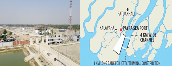
Payra Sea Port is the 3rd seaport of Bangladesh located in general area in between latitude 21.9890 North and longitude 90.2792 East on the bank of Rabnabad Channel under Kalapara, a sub district of Patuakali. In order to increase the economic activities in the central zone and meet the future demand, Payra Sea Port Act 2013 was passed in National Parliament on 10 November 2013. Honourable Prime Minister Sheikh Hasina inaugurated country’s 3rd seaport named as “Payra Sea Port” at Rabnabad Channel at Patuakhali district on 19 November 2013.
Government has taken Short, Mid & Long-Term Plan to develop a state of art modern seaport. As Short-Term Plan, Payra Port Authority is set operate the port activities by offloading cargos from motherships at outer/inner anchorage and transported to the hinterlands through river routes. All the necessary preparations like Custom Clearance Facilities, VHF communication, Banking, enlistment of Ship handling operators, C&F, Shipping agent, Channel Marking with Laying of Buoys at River and approach channel, Marking of Payra inner and outer Anchorage area, Implementation of ISPS code, UN Locator Code, and port security including a Bangladesh Coastguard station with high speed vessel and manpower etc have been completed.
Under Long Term Plan, by 2023 the port would be fully operational with a 16 m channel where minimum 10 km container & other terminals with all other associated facilities like establishing EEZ, Airport, Port city, Dockyard/Shipyard, Echo Tourism etc centring to the port. The Port authority has taken a mega budget estimate under the Long-term plan by phases to complete the envisioned infrastructural facilities and make the port fully operational by 2015.
Presently the port users are using River Route connecting to Dhaka and other districts of the country. In the river route, vessels more than 4-meter draught with bulk cargo are plying day and night irrespective of tide. Various commodities including food grain, cement, fertilizer and other bulk are transported from Payra to Dhaka and other destinations through internal waterways.
PPA’S objective focuses mainly on providing necessary services and facilities to the port users efficiently and effectively at competitive price. Though PPA started its Ltd scale port operations by offloading bulk cargoes at inner/outer anchorage, with the passage of time PPA is going to handle maximum volume of container and bulk cargoes of Bangladesh using the geographical advantages, good hinterland connectivity
Port website: http://ppa.gov.bd/
|
Port Location and Contact |
|
|---|---|
|
Country |
Bangladesh |
|
Province or District |
Patuakhali |
|
Nearest Town or City with Distance from Port |
Kalapara 5 km |
|
Port's Complete Name |
Port of Payra |
|
Latitude |
21.9890 N |
|
Longitude |
90.2792 E |
|
Managing Company or Port Authority |
Payra Port Authority |
Port Picture
List of Officers- PPA
|
Sl |
Name |
Designation |
Contact Details |
|---|---|---|---|
|
1 |
Commodore M Jahangir Alam, (E), NUP, ndc, psc, BN |
Chairman |
+88029348421 Fax:+88029349175 |
|
2 |
Commodore Md. Ashraful Haque Chowdhury, psc, BN |
Member (Harbour & Marine) |
|
|
3 |
Captain M. Muniruzzaman, (E), BN |
Member (Engineering and Development) |
02-9350125 |
|
4 |
Commander M Rafiul Hassain (TAS) psc, BN, (Rtd.) |
Member (Admin & Finance) |
02-9349175 |
|
5 |
Mohiuddin Ahmed Khan (Joint Secretary) |
Director (Administration) |
|
|
6 |
Md. Elias Reja |
Chief financial and accounting officer |
|
|
7 |
Quazi Wasif Ahmad |
Chief Engineer |
|
|
8 |
Commander Haider Jahan Khon Emon (H-1), psc, BN |
Chief Hydrographer |
|
|
9 |
Md. Nasir Uddin |
Deputy Ch. Engineer (Jetty & Harbour) |
|
|
10 |
Captain SM Sharifur Rahaman |
Dock Master |
|
|
12 |
Md. Saifur Rahman |
Joint Chief Planning |
|
|
13 |
Tayebur Rahman |
Deputy Director (Admin) |
|
|
14 |
Azizur Rahman |
Deputy Director (Traffic) |
|
|
15 |
Captain Asif Ahmed |
Pilot |
|
|
16 |
Mohammad Soadrul Amin |
Deputy Director, MIS |
|
|
17 |
Mostafa Ashique Ali |
Executive Engineer (Jetty) |
|
|
18 |
Md. Abul Kalam Azad Molla |
Executive Engineer (Harbour) |
|
|
19 |
Azizur Rahman |
Assistant Director (Admin) |
|
|
20 |
Md. Rajibul Hasan |
Assistant Director (Accounts) |
|
|
21 |
Md. Sohel Mir |
Assistant Director (Security) |
|
|
22 |
Md. Sajidul Islam Sobuj |
Assistant Secretary (Coordination) |
|
|
23 |
Md. Asadulla Ashik |
Assistant Engineer (Electrical) |
|
|
24 |
S M Imties Islam |
Superintendent (Light and Mooring) |
|
|
25 |
Md. Aminul Haque |
Assistant Chief (Prog) |
01515201401 |
|
26 |
Anup Kumar Sarker |
Medical Officer |
|
|
27 |
Delwar Hosen |
Personal Secretary |
|
|
28 |
Md. Rokibul Islam |
Security Officer |
Port Facilities and Infrastructure
Present Facilities of Port
As the port is under construction and lot of development works are going on to enrich the capacity and facilities of the port. However, some of the existing facilities are shown below:
|
Jetty |
ONE jetty (80M) to be used as service Jetty for own use and Cargo handling usage in small scale. |
|---|---|
|
Draught |
Maximum allowable draught of ships at Jetty is 6 M only |
|
Storage |
One Transit shed of 1,00,000 Sq. Ft |
|
Infrastructure |
Office/Admin building, Officer’s BOQ, Staff Accommodation, Multi-purpose Complex, Generator, Sub-station and some other small buildings and Shades have been constructed. |
|
Handling Equipment |
|
Port General Information
|
Port various Data
|
Hydrographic Data |
|
|---|---|
|
Salinity |
Salinity at Rabnabad Channel varies from 0.1 gms/1000c.c at low water to 0.2gms/ 1000c.c at high water during monsoons and from 2.5gms/1000c.c at low water to 16.5gms/1000c.c at high water during dry season. Salinity at Kajal river varies from 0.15gms/1000c.c at low water to 3.3gms/1000c.c at high water during monsoon and from 10gms/1000cc at low water to 27 gms/1000cc at high water during dry season. |
|
Width of Channel |
The width of the navigational channel (5.0m. contour) varies from place to place. From fairway to the mouth of Rabnabad Channel there is no restriction of Navigational width. A minimum of 250 m Channel width is maintained in Kajal- Tetulia route. |
|
Wind Velocity |
The weather in Bangladesh is largely governed by the monsoon. The prevailing wind directions are from South to South East during the months of April through September. After taking easterly direction for a while the wind turns to the northerly and north-easterly directions, the later prevail from November to January. During the months of February and March, winds turn via westerly direction back to the Southerly to South Easterly. In excess of 20 Knots/ Beaufort wind scale 5 prevails for 6 percent to time while those in excess of 30 Knots/Beaufort wind scale 7 persists for about 0.1 percent of the time during cyclones i.e. During the transition between monsoon and dry seasons in May, October, and November. The area of Payra port experienced four severe Cyclonic water surges during the last 44 years. In 1960 & 1963 speeds recorded were 125 Knots Max. In 1970 and 1991 speeds were recorded 138 Knots max. and 180 Knots max. respectively. |
|
Tidal Ranges |
The tides are important for navigations as determining the possibility of crossing the shallow area between Payra Fairway and the Meghna entrance at Hizla point and the Bars within Port Limit. The tides are semi-diurnal with prominent diurnal effect. The approx. Tidal Ranges at Rabnabad Channel and Amirganj (Meghna juncture) from Chart Datum (ISLWL – Indian Spring Low Water Level which is 1.673m below mean sea level) are as follows: At Rabnabad Channel: 0.8m.-3.5m. (above ISLWL) At Amirganj (Meghna juncture): 0.7m-2.8m. (above ISLWL). |
|
Night Navigation |
The entire channel is demarcated by let- buoys. There is no limitation for night navigation for entering/leaving harbour. |
|
Waves |
The waves are generally low shown distinct relation with the wind. Maximum wave heights over 2m were recorded only on a few days during the small parts of days. The wave periods vary between 3-4 seconds of waves of about 0.5m and about six seconds for waves of 2m. These are from an observation made by NEI (Netherlands Economic Institute) 1972–1977. During the months May to October freshets are expected, Freshets are caused by the normal velocity of flow of ebb tide augmented by the flow of an additional volume of water that drains into the river from the catchment area. Freshets are expected when rainfall intensity reaches 200mm in 24 hours. The density of water varies at each turn of the tide. Masters are advised to obtain the Circular from the local agents and follow the instructions closely. |
|
Anchorage |
A wide anchorage is established at the outer and inner Anchorage of PPA: LONGITUDE/LATITUDE
|
Port Performance
Before being fully operational the port has started its activities. Since Nov 2013 till Mar 2019 the port has managed following 32 ships:
|
Sl |
Name of Vessel |
Flag |
DWT |
L x B |
Draught |
D.O.A |
Quantity |
|---|---|---|---|---|---|---|---|
|
1 |
Banglar Mamata |
Bangladesh [BD] |
15,877 |
154.16m × 22.26m |
6.95m |
15-Nov-13 |
|
|
2 |
Fortune Bird |
Hong Kong [HK] |
55,640 |
189.99m × 32.26m |
6.80m |
1-Aug-16 |
20810MT |
|
3 |
FS Beach |
Vietnam [VN] |
8,215 |
136.4m × 20.2m |
7.00m |
14-Aug-16 |
12502MT |
|
4 |
Battang Hari 30 |
Indonesia [ID] |
1,630 |
95m × 19m |
5.00m |
6-Sep-16 |
1 unit |
|
5 |
Matsumae |
Panama [PA] |
9,998 |
124.56m × 21.2m |
5.00m |
27-Sep-16 |
106Pckg |
|
6 |
Kulsamut |
Thailand [TH] |
12,665 |
140.5m × 20.8m |
7.50m |
7-Oct-16 |
8000 MT |
|
7 |
Teng Hang |
Hong Kong [HK] |
35,023 |
179.88m × 28.4m |
7.30m |
17-Oct-16 |
26000 MT |
|
8 |
Combi Dock 1 |
Antigua Barbuda |
10,480 |
169.4m × 25.73m |
6.20m |
30-Oct-16 |
1 Unit |
|
9 |
Zealand Rotterdam |
Netherlands [NL] |
57,157 |
190m × 32.26m |
7.30m |
30-Jan-17 |
21195 MT |
|
10 |
Desert Unity |
Marshall Is [MH] |
54,043 |
189.99m × 32.26m |
7.30m |
2-Feb-17 |
14700 MT |
|
11 |
Canary |
Marshall Is [MH] |
57,825 |
189.99m × 32.3m |
6.60m |
14-Mar-17 |
17500 MT |
|
12 |
Safesea Neha II |
Liberia [LR] |
53,389 |
189.99m × 32.26m |
7.40m |
2-Oct-17 |
21300 MT |
|
13 |
Wish Way |
Panama [PA] |
21,243 |
156m × 36m |
7.00m |
25-Nov-17 |
1 Unit |
|
14 |
Dubai Ambassador |
Panama [PA] |
56,060 |
189.99m × 32.26m |
5.80m |
17-Dec-17 |
12000 MT |
|
15 |
Zhen Hua 15 |
Hong Kong [HK] |
46,671 |
233.3m × 42m |
8.30m |
4-Jan-18 |
6547.16 MT |
|
16 |
KSL Lake Hill |
Panama [PA] |
3,375 |
81m × 13.6m |
5.50m |
17-Jan-18 |
3000 MT |
|
17 |
Icarius |
Marshall Is [MH] |
55,921 |
189.99m × 32.26m |
7.05m |
10-Feb-18 |
20000 MT |
|
18 |
Kyriakos |
Panama [PA] |
29,926 |
171.45m × 27.02m |
6.95m |
26-Feb-18 |
14800 MT |
|
19 |
NK Khaleda |
Togo [TG] |
2,594 |
83.78m × 12.7m |
5.40m |
1-Mar-18 |
2400 MT |
|
20 |
Yin Fu |
China [CN] |
48,909 |
190m × 32.26m |
6.60m |
13-Apr-18 |
20000 MT |
|
21 |
Tan Binh 136 |
Vietnam [VN] |
29,887 |
170.7m × 27m |
7.20m |
19-Apr-18 |
17000 MT |
|
22 |
Knossos |
Malta [MT] |
56,763 |
189.99m × 32.26m |
7.30m |
12-Aug-18 |
22000 MT |
|
23 |
Development Way |
Panama [PA] |
31,287 |
215.00mx34.04m |
12.30m |
16-Oct-18 |
|
|
24 |
Sabada |
Moldova [MD] |
6,507 |
102.79mx17.03m |
7.15m |
12-Nov-18 |
6000 MT |
|
25 |
Equinox Agnandoussa |
Cayman Island [KY] |
58,680 |
197.00mx32.26m |
12.90m |
20-Nov-18 |
56810 MT |
|
26 |
Maria |
Marshall Is [MH] |
57,070 |
189.99mx32.26m |
12.10m |
30-Nov-18 |
50000 MT |
|
27 |
Tiger Hebei |
Hong Kong [HK] |
63,483 |
199.9m × 32.32m |
13.50m |
19-Dec-18 |
62,290 MT |
|
28 |
Mimi Selmer |
Marshall Is [MH] |
55,711 |
189.99m × 32.3m |
12.30m |
23-Jan-19 |
51,922 MT |
|
29 |
Xin Chen Hai Yang |
China [CN] |
24,242 |
153.46m × 38.6m |
6.00m |
31-Jan-19 |
4 Unit |
|
30 |
Sabada |
Moldova [MD] |
6,507 |
102.79mx17.03m |
6.93m |
19-Feb-19 |
6000 MT |
|
31 |
Sabada |
Moldova [MD] |
6,507 |
102.79mx17.03m |
6.95m |
17-Mar-19 |
6000 MT |
|
32 |
Ocean Bao |
Hong Kong [HK] |
63,577 |
199.9m × 32.26m |
12.80m |
27-Mar-19 |
58,306 MT |
Important News of the PPA
|
Sl |
Title |
|
1 |
|
|
2 |
|
|
3 |
List of Future development Projects
|
Sl |
Project Name |
|---|---|
|
1 |
Developing Infrastructure Support Facilities (DISF) |
|
2 |
PPA Master Plan |
|
3 |
Payra Port First Terminal (PPFT) |
|
4 |
Rabnabad Channel Capital and Maintenance Dredging of Payra Port |
|
5 |
Coal/Bulk Terminal (CBT) |
|
6 |
Multipurpose Terminal (MPT) |
2.1.4 Bangladesh Port of Matarbari
Port Overview
Matarbari Port is a proposed deep seaport in Matarbari, Cox's Bazar District, Chattogram Division, Bangladesh. The port will be full commercial opening by expanding Coal jetty for berthing of vessels for the Maheshkhali power plant in Cox's Bazar district. At least 16.3-meter-deep ships can be easily accessible Matarbari Port. With the depth of the proposed Matarbari port being 16.3 meters, every ship will be able to bring more than 8000 containers. Currently, vessels with less than a 9-meter draft can call at the country’s two seaports at Chattogram and Mongla.
JICA will build a 15-kilometer long channel for construction of Matarbari port. Main navigational channel will be 350 meters wide. The 100-meter-long jetty will be constructed under the port's financing. The deep seaport’s multi-purpose terminal will be ready for container shipping vessels by November 2022, and a coal terminal will be constructed by August 2022
In the first phase of construction, the container terminal will be built on 18 hectares, have a 460-meter berth, be able to accommodate 8,000 TEU vessels, and have an annual capacity of 600,000 to 1.1 million TEU. Later, the container terminal will be expanded, comprise 70 hectares, have an 1,850-meter berth, and have a 2.8-million-MT capacity. The multi-purpose terminal will be built on 17 hectares, have a 300-meter berth, and be able to accommodate vessels with up to 70,000 dwt. Its annual capacity will be 2.25 million tonnes
Key port information may also be found at: http://www.maritime-database.com.
Port Picture
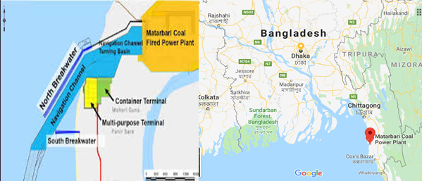
Matarbari Deep Sea port at a glance
|
Port Location and Contact |
|
|---|---|
|
Country |
Bangladesh |
|
Province or District |
Maheshkhali Upazila, Cox’s Bazar |
|
Port's Complete Name |
Port of Matarbari |
|
Latitude |
21.6914°N |
|
Longitude |
91.8590°E |
|
Managing Company or Port Authority |
Matarbari Port Authority |
|
To be opened |
2023 |
|
Type of harbor |
Deep sea port |
|
Length of Nav channel |
15-kilometer |
|
wide of Nav channel |
350 meters |
|
Draught |
16.3 meters |
Envision of the port
In the first phase of stage one, according to JICA's presentation, the port will have annual handling capacity of 0.8 million TEUs of containers and 2.5 million tonnes of bulk cargos. The port will be connected to the national highway and also have access to Chattogram and Cox's Bazar.
In the second phase of stage one, the port will have three jetties ready for container handling and four to six jetties for multipurpose use by 2028. Meanwhile, its container handling capacity will grow to 2.8 million TEUs and cargo handling capacity will reach 2.5 million tonnes per year.
After the completion of the final stage by 2035, the port will have the capacity to handle 4.8 million TEUs of containers and 16 to 38 million tonnes of bulk cargos. By 2024, the port will have rail connectivity through Dohazari-Cox's Bazaar line. An inland container depot will also be built by then.
By 2035, the container terminal's berth will reach 1,850-metre on 70 hectares area. Japan has agreed to invest US$20 billion for Moheshkhali-Matarbari initiative, of which half will come from its low-cost ODA (official development assistance). The rest will come as private sector investment.
2.2 Bangladesh Aviation

Introduction to Civil Aviation Authority of Bangladesh (CAAB)
As a member of the International Civil Aviation Organization (ICAO), the CAAB is putting in place necessary infrastructural facilities for movement of domestic and international aircraft. To ensure quick and secured movement of foreign and domestic aircraft in the Bangladeshi sky territory, the CAAB builds and maintains airports, air traffic, and air navigation facilities; installs telecommunication services and provides other facilities for the passengers.
In the year 1985, the Government of the People's Republic of Bangladesh formed Civil Aviation Authority, Bangladesh (CAAB) vide Ordinance No. XXXVIII of 1985, titled The Civil Aviation Authority Ordinance, 1985. CAAB functions as the regulatory body for all aviation-related activities in Bangladesh. Aside from being the aeronautical service provider, it is also responsible for safe, expeditious, and efficient flow of air traffic within the Flight Information Region (FIR) bounded by the international geographic boundary of Bangladesh. This organization is the custodian of all airfields and allied facilities including air navigation facilities. With about 3,000 employees, CAAB operates and maintains the major airports in Bangladesh and all the air traffic control. For further details following link is pertinent: https://caab.portal.gov.bd/
Important Contact details of CAAB
|
Sl |
Name |
Designation and email |
Telephone and fax |
|---|---|---|---|
|
1 |
Air Vice Marshal M Mafidur Rahman BSP, BUP, ndu, afwc, psc |
Designation: Chairman Email: chairman@caab.gov.bd |
Phone: +880 2 8901400 Fax: +880 2 8901411 |
|
2 |
Air Cdre Md. Khalid Hossain BUP, ndc, fawc, psc |
Designation: Member (Ops & Plang) Email: mops@caab.gov.bd |
Phone: +880 2 8901405 Fax: +880 2 8901428 |
|
3 |
Md. Hafizur Rahman (Additional Secretary) |
Designation: Member (Admin), Email: madmin@caab.gov.bd |
Phone: +880 2 8901068 |
|
4 |
Md. Mizanur Rahman (Joint Secretary) |
Designation: Member (Finance), Email: mfin@caab.gov.bd |
Phone: +880 2 8901402 |
|
5 |
Shah Md. Imdadul Haque (Additional Secretary) |
Designation: Member (Security), Email: mavsec@caab.gov.bd |
Phone: +880 2 8901231 |
|
6 |
Group Captain Chy M Zia Ul Kabir GD(P) |
Designation: Director (Flight Safety & Regulations) Email: dfsr@caab.gov.bd |
Phone: +880 2 8901406 |
|
7 |
Md. Abul Kalam Azad Address: AFTN: VGHQYAYS |
Designation: Director (ATS and Aerodromes) Email: datsaero@caab.gov.bd |
Phone: +880 2 8901404 |
|
8 |
Group Captain, Abu Sayeed Mehboob Khan, psc |
Designation: Director, Hazrat Shahjalal International Airport Email: dhsia@caab.gov.bd |
Phone: +880 2 8901449 Fax (office): +880 2 8901450 |
Disaster Response by CAAB
Dhaka and Chattogram Airports Ready for Post-Disaster Needs
|
Airports of Dhaka and Chattogram are prepared to effectively coordinate and handle the massive influx of emergency supplies that floods in after any natural disaster. As part of a global joint initiative between DHL and UNDP, over 20 airport staff and government officials of both airports were trained in 2011 to manage emergency operations, assess local requirements and create detailed contingency plans. A refresher of the same training is currently (2019) being considered. The UNDP-supported Comprehensive Disaster Management Programme 2010-2014 (CDMP II) will continue to work with the Civil Aviation Authority agencies to ensure that the training outcomes are integrated into the broader disaster risk reduction and preparedness activities. |
Procedures for Foreign Registered Aircraft
The provisions detailed here under are related to non-emergency periods. There are, apparently, no specific and detailed provisions for emergency relief operations. Nevertheless, as soon as an emergency state is declared by the authorities, specific procedures for international relief cargo will be edited and implemented.
Entry
All flights into, from or over the territory of Bangladesh and landings in Bangladesh territory shall be carried out in accordance with the permission received from Chairman, Civil Aviation Authority and in accordance with the national regulations. Aircraft landing in or departing from the territory of Bangladesh must first land at or finally depart from an International Airport. The aircraft, after landing at airport shall not proceed further unless the pilot in command has obtained necessary customs and other clearances in writing from officer of such organization as duly authorized by the Government. No aircraft, including aircraft engaged in a scheduled air transport service, shall make flights into or in transit across the territory of Bangladesh except in accordance with the above conditions.
Scheduled Flights
For operation of regular international scheduled flights operated by foreign airlines into or in transit across Bangladesh, the following requirements must be met:
- The state of the airline must be a party either to the International Air Services Transit Agreement, 1944 or a party to bilateral air transport agreement with the Bangladesh Government or must obtain special permission under a bilateral agreement or arrangement.
- The airline must be eligible to make the flights under the provisions of a bilateral or multilateral agreement to which the state of the airline and Bangladesh are contracting parties and must have a permit to operate into or in transit across Bangladesh airspace. Applications for such permits shall be submitted to the Chairman, Civil Aviation Authority, Kurmitola, Dhaka-1229 well in advance.
- Aircraft belonging to or operated for or on behalf of the Government of South Africa, Israel and Taiwan are debarred from flying into or in transit across the territory of Bangladesh.
Non-scheduled Flights
If an operator intends to perform a (series of) non-scheduled flight(s) into Bangladesh for the purpose of taking on or discharging passenger, cargo or mail, he shall apply in writing to the Chairman, Civil Aviation Authority, Government of the People's Republic of Bangladesh, Kurmitola, Dhaka-1229 and obtain prior approval to carry out such operations not less that 15 (fifteen) working days in advance of the intended landing.
The application must include the following information in the order shown hereunder:
- Name, address and nationality of operator of aircraft;
- Type of aircraft, Nationality and Registration Marks of the aircraft;
- Call sign of aircraft;
- Date and time of arrival at, and departure from Bangladesh;
- Place or places of embarkation or disembarkation abroad as the case may be of passengers and/or freight;
- Purpose of flight and details of passengers and/or nature and amount of freight;
- Name, address and business of charterer, if any;
- Route to be flown;
- Such other information as may be required by the Chairman, Civil Aviation Authority.
Charter Flights
If an operator intends to perform a (series of) non-scheduled flight(s) for the purpose of taking on or discharging passengers, cargo or mail in Bangladesh to/from a place outside Bangladesh, he shall apply to and obtain prior approval from the Chairman, Civil Aviation Authority for the exercise of such traffic rights. The application must contain the particulars specified for non-scheduled flights.
No passenger or freight flights originating in Bangladesh for a place outside Bangladesh may be picked up unless the charter/or hire of the whole or part of the space on such aircraft, if considered to have been arranged through the agency of National Operator, and with the prior consent of the Chairman, Civil Aviation Authority of Bangladesh.
Charter flight(s) by Foreign Operators may be permitted provided the Charterer along with the application produces a declaration from the National Carrier stating that they (National Carrier) are not in a position to meet the requirement of the Charterer.
No advertisement in respect of such flights soliciting booking of traffic or purporting to notify availability of space in aircraft shall be made in any manner whatsoever, either by the person or the operator.
Charter Flights by foreign operators not exercising traffic rights when transiting through Bangladesh
Subject to the observance of the terms of the Convention on International Civil Aviation 1944, application must be made at least 3 working days before the intended flight, and obtain prior permission from the Chairman, Civil Aviation Authority of Bangladesh for fall aircraft of the Contracting states of the above-mentioned convention desiring to carry out non-scheduled flight into, or in transit non-stop across Bangladesh and to make stops for non-traffic purposes in Bangladesh. The application must contain the following particulars in the order shown hereunder:
- Name, address and nationality of aircraft operator.
- Type, Nationality and Registration marks of the aircraft
- Date and time of arrival at, and departure from Bangladesh.
- Purpose of flight and details of passengers and/or nature and amount of freight.
- Name, address and business of charterer, if any.
- Route to be flown.
Flights of State Aircraft
If a State intends to perform a (Series of) non-schedule flight(s) into Bangladesh to operate military aircraft, it shall apply to the Government of Bangladesh, Ministry of Affairs, Dhaka, Bangladesh (Telegraphic Address- (PARARASTRA DHAKA) for permission to carry out such operation not less than 15 (fifteen) working days in advance of the intended landing. The application must include the following information in the order shown hereunder:
- Name of operator, Type of aircraft and registration marks.
- Date and time of arrival and departure from Bangladesh.
- Place or places of embarkation or disembarkation of passengers and/or freight, etc.
- purpose of flight and number of passengers and/or nature and amount of freight.
- Route of flight.
- A certificate to the effect that " No war-like materials, such as arms, ammunition, explosives (except escape/aid explosives), pyrotechnics (except very pistol signal cartridges) nuclear fissionable materials, ABC gases, photographic equipment and materials (whether installed or
- not electronic devices other than required for normal operation of the aircraft, are being carried by the aircraft.
Documentary requirements for clearance of aircraft
It is necessary that the under mentioned aircraft documents be submitted by airline operators for clearance on entry and departure of their aircraft to and from Bangladesh. All documents listed below must follow the ICAO standard format as set forth in the relevant appendices to Annex 9 and are acceptable when furnished in English and completed in legible handwriting.
Aircraft documents required for arrival and departure:
|
Required by |
General Declaration |
Passenger Manifest |
Cargo Manifest |
|---|---|---|---|
|
Customs Officer |
1 |
2 |
2 |
|
Immigration Officer |
1 |
1 |
... |
|
Airport Health Officer |
2 |
1 |
... |
|
Plant Quarantine Officer |
1* |
1* |
1* |
|
* For arriving aircraft only |
|||
Notes:
- One copy of the General Declaration is endorsed and returned by Customs, Signifying clearances.
- If no passengers are embarking (disembarking) and no articles are laded (unladed), no aircraft documents except copies of the General declaration need be submitted to the above authorities.
Public health measures applied to aircraft
All international travelers coming to Bangladesh from yellow fever zone or in transit through yellow fever zone must possess a valid International Certificate of yellow fever vaccination. There will not be any exception for age, sex and status.
Yellow Fever: The vaccine used must be approved by the WHO and the vaccination centre must be notified by the WHO. Yellow fever epidemic zones of Africa and South America are given below:
Africa: Angola, Benin Botswana, Burundi, Central African Republic, Chad, Congo, Equatorial Guinea, Ethiopia, Gabon, Gambia, Ghana, Guinea, Guinea-Bissau, Ivory Coast, Kenya, Liberia, Malawi, Mali, Mauritania, Niger, Nigeria, Rwanda, Sao Tome and Principe, Senegal, Sierra Leone, Somalia, Sudan (South of 15 N), Togo, Uganda, United Republic of Cameroon, United Republic of Tanzania, Upper Volta, Zaire, Zambia.
South America: Belize, Bolivia, Brazil, Colombia, Costa Rica, Ecuador, French Guiana, Guatemala, Guyana, Honduras, Nicaragua, Panama, Peru, Suriname, Trinidad, Tobago and Venezuela,
Note: When a case of yellow fever is reported from any Country, that country is regarded by the Government of Bangladesh as infected with yellow fever and is added to the above list.
In case any traveler fails to produce such valid certificate he will either not be permitted to enter Bangladesh or will be isolated till he is considered free from infection by local Health Administration. A simplified E/D-cum Health Card is to be filled in by an arriving passenger of all categories. Desensitization of aircraft in flight is not acceptable. However, spraying on the ground is not required provided a "Desensitization Certificate" from the place of origin is carried on the aircraft. Aircraft and aircrew engaged on non-scheduled flights to Bangladesh shall comply with the requirements of the Convention on International Civil Aviation (Chicago, 1944) and the national regulations in force in Bangladesh.
Cabotage Carriage
No passenger or freight originating at a point in Bangladesh and destined for another point in Bangladesh may be picked up by a foreign operator. If an operator intends to perform a (series of) non-scheduled flight(s) originating at a point in Bangladesh and destined for another point in Bangladesh for the purpose fo taking or discharging passengers, cargo or mail, he shall have to provide satisfactory evidence that no Bangladesh registered operator is in a position to carry the passengers or freight available between the two points in Bangladesh. Thereafter, he shall apply to the Chairman, Civil Aviation Authority for permission to carry out such charter flights.
Other Commercial Flights
If an operator intends to perform a (series of) non-scheduled commercial flight(s) e.g. Business flights, survey flights or spraying flights in Bangladesh he shall apply giving details of the flights(s) to the Chairman, Civil Aviation Authority, Kurmitola, Dhaka-1229 for permission to carry out such operations. Grant of permission will be governed by the merits of the individual cases of consultation with any other department of Government of Bangladesh that may be concerned.
Employment of foreign aircraft for public transportation or aerial works
An aircraft not registered in Bangladesh is precluded from employment as a public transport aircraft or an aerial work aircraft in Bangladesh territory without special permission from the government of Bangladesh, an aircraft owned by a person other than a national of Bangladesh who is resident in resident in or carrying on business in Bangladesh may be registered as Bangladesh aircraft, but is precluded from employment as public transport aircraft or an aerial work aircraft without special authorization from the chairman, CAAB.
Cargo
Regulations
concerning importation, transshipment and exportation of
cargo
Customs requirements: Carriage of arms and explosives
- The Carriage in aircraft of any arms, ammunition, explosives, military stores or articles of highly inflammable nature is prohibited under the Bangladesh Aircraft Rules, except explosives or other articles required exclusively for the working of the aircraft and such arms and ammunition as may reasonably be required for private use.
- No civil registered aircraft, whether national or foreign shall carry ammunition of war or implements of war in or across the territories of Bangladesh.
- Sporting arms and ammunition, explosives (other than those which are used for handling and operating an aircraft), poisons, corrosive liquids or irritant gases, as aesthetic gases, liquids and compounds, flammable solids, liquids or gases, oxidizing materials shall not be carried in bulk on any passenger carrying aircraft, whether national or foreign in or across the territory of Bangladesh except in such quantities as may be notified from time to time.
- When any of the articles mentioned in above is carried, the
carrier shall ensure that:
- The quantity is within the prescribed limits;
- It is properly and securely packed and correctly labeled showing the content of the package with appropriate instructions for handling;
- It is stored in such a place that if the container is damaged, the crew, passenger and the main structure of the aircraft is not likely to endangered by its effects.
- Articles mentioned in paragraph 3 may be transited in bulk through Bangladesh on a foreign registered aircraft provided the owner of the aircraft has obtained prior permission of its Government for conveyance of the cargo on board and 24 hours advance notice of the arrival of aircraft is given to the Airport of intended landing in Bangladesh.
A list of articles which are classified a "Prohibited Cargo" or "Dangerous Cargo" is available at all civil aerodromes.
Plant Quarantine Requirements: Importation of Plants and seeds
The importation of plants and seeds into Bangladesh is governed by special rules. In every case where it is intended to carry plants or seeds on aircraft entering Bangladesh, enquiries should first be made from the Department of Plant Protection, Ministry of Agriculture, Agricultural Complex, Farmgate, Dhaka.
Customs Duty on Airport
No customs duty is levied on an aircraft which is in transit or is to make a temporary stay in Bangladesh for a period of less than six months, However, declaration must be supplied to the Customs Officer at the Airport of entry that the aircraft is in transit or that it is intended to re-export the aircraft within this period.
Wireless Apparatus
In Conformity with the provisions of the International Telecommunications Convention (Atlantic City, 1947) aircraft entering Bangladesh carrying radio transmitting apparatus are required to have a license3 for the apparatus and the operator must hold a certificate of competency. If an aircraft equipped with wireless apparatus arrives in Bangladesh and does not carry the required license and certificate issued by the State in which it is registered, a license for the apparatus and a certificate for the operator must be obtained from the General Manager, Telephones (Wireless Branch), Dhaka, before proceeding.
Airports in Bangladesh
CAAB regulates and maintains total 3 International airports and 7 Domestic airports (of which 2 airports are left unused) and 4 STOL (Short Take-Off and Landing) ports for the convenience of airlines as and when necessary specially in time of crisis. Of the 14 Airports and STOL ports of CAAB, 13 are being operated on subsidy. Hazrat Shahjalal International Airport is the only airport of the Authority, which has surplus earning over its expenditure.
|
International Airports |
|
|---|---|
|
Domestic Airport |
|
| Short Take-off and Landing |
|
|
Note: Place for another airport named Khan Jahan Ali airport is air marked near Mongla Port, Bagerhat and at present its boundary wall is under construction. |
|
Key airport information may also be found at: World Aero Data information on Bangladesh
For information on Bangladesh airports contact details, please see the following link:
4.5 Bangladesh Airport Contact List
2.2.2 Bangladesh Shah Amanat International Airport
| Location Details | |||
|---|---|---|---|
| Country | Bangladesh | Latitude | 22.24972 |
| Province / District | Chittagong | Longitude | 91.81333 |
| Town or City (Closest) |
Chittagong 10 NM N South of Chittagong City |
Elevation (ft and m) | 12 ft / 4 m |
| Airfield Name | Shah Amanat International Airport | IATA and ICAO Codes | CGP / VGEG |
| Open From (hours) | 00.00 | Open To (hours) | 00.00 |
Introduction and Overview
Shah Amanat International Airport (SAIA) is the second-largest international airport in Bangladesh after Shahjalal International Airport in Dhaka. The airport is operated and maintained by the Civil Aviation Authority of Bangladesh. It is used by the Bangladesh Air Force as a part of 'BAF Zahurul Haq Base'. It was renamed on 2 April 2005 after an Islamic saint, Shah Amanat. It is capable of annually handling approx. 2 million passengers and 10,000 MTs of cargo. SAIA also serves as a base to Arirang Flying School. The airport is in the Patenga area of the city, 20 kilometres west from the city's main commercial hub, GEC Circle and 18.5 km south of the city's railway station on the north bank of the Karnaphuli River.
The airfield was built in the early 1940s under the British rule. Known as Chattogram Airfield during World War II, it was used as a combat airfield, as well as a supply point and photographic reconnaissance base by the United States Army Air Forces' Tenth Air Force during the Burma Campaign 1944-1945. After liberation initially it was mainly used for connecting Dhaka and Chattogram. But in the mid-1990s Bangladesh Biman started it’s international flights to Bangkok, Dubai and all other major Gulf cities and it officially became an international airport.
In March 1998, a major renovation and expansion began, which ended in December 2000. CAAB received financial assistance from the Japan International Cooperation Agency for the US$51.57 million upgrade. The upgrade modernised the terminal with new and better seats, more check-in counters, better security equipment and other facilities. The Air Traffic Control tower received new hi-tech equipment such as 3D radar. The runway, taxiways and the tarmac were expanded and improved. After the upgrade, aircraft such as the Boeing 747-400 or the Airbus A 340 can land easily. The Airport is ICAO certified in 2005.
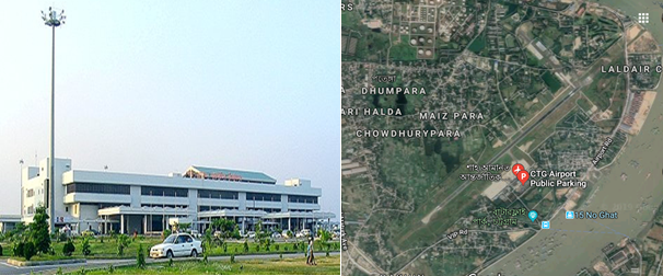
Contact details of the Airport:
|
Name & Address |
Contact Names & Email |
Telephone & Fax |
|---|---|---|
|
Shah Amanat International Airport, Chattogram |
Name: Wg Cdr Sarwar-e- Zaman Title: Airport Manager Email: apmctg@caab.gov.bd |
Tel: 880 31 2500900 (off) |
General Information of SAIA
Briefly Runway and Apron
|
Runway & Lighting
|
Single Backtrack Runway 05/23 2940m X 45m |
|
|---|---|---|
|
PCN 66 F/C/X/T |
||
|
Runway end turning pads 120m X 80m |
||
|
Precision approach CAT1 lights on RWY 23 |
||
|
Simple approach lights RWY 05 |
||
|
CAT-1 ILS System for RWY23 |
||
|
Apron |
Single Apron 750’ X 430’ with head of stand roadway surrounded by soft grassy areas |
|
|
Four main parking stands are nose in – push out configuration. |
||
|
Standard parking: 2x747-400 + 1x DC10+1 xA380 |
||
|
Dense parking: Standard Parking + 4AN12’s |
||
|
Two taxiway entrances / exits |
||
|
Lighting masts at the head of each stand. |
||
|
Two fixed air bridges which are capable of handling Boeing 747-400 sized A/C. |
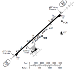
Terminal building
The airport's sole 20,000 m2 passenger terminal is divided into two parts: International and Domestic with a boarding bridge in each. The International part of the terminal is larger than the Domestic one due to higher number of passengers. The building is divided into two floors: The lower floor is used for checking in, boarding or getting off small planes and receiving luggage. The upper floor is used for boarding or getting off large planes only. The 2nd Terminal Building is in the active consideration of authority.
Following are some dotted points of the existing Terminal:
- Modern concrete arrival / departure terminal capable of handling approx 2 million passenger per annum.
- 4 departure lounges with suitable seating areas capable of holding 1500 people in total.
- 16 check-in desks.
- 1 domestic arrivals hall and 1 large international arrivals hall.
- Overall size of the terminal building is 18,600m².
- Total number of Bays- 10 (6-Old and 4-New).
Control Tower
The Air Traffic Control Tower is 50 meters west of the airport terminal. This single ATC tower controlling both commercial and military operations. It has a clear view of the tarmac and taxiways but is far from the runway. Heavy rain or fog can make it difficult for controllers to see planes taking off or landing. At present total 16 civilian ATC staff supplemented by BAF controllers work here. They provide 24-hour ATC coverage; however, normal operations are 18-20-hour days. No traffic flow restrictions.
|
Contact : Senior Air Traffic Control Officer, Phone : +88 0312 500 954 and +88 0312 500 982 |
Taxiway and Tarmac
The airport has 2 taxiways, Alpha and Bravo, that directly leads to the tarmac (or aircraft parking zone) from the runway. The tarmac can accommodate a maximum of four aircraft; two wide-body Boeing 747-400s, a wide-body McDonnell Douglas DC-10 and a narrow-body Airbus A320 can be parked there at once. The airport has two boarding bridges and two passenger steps. The parking points are usually empty as most of the planes that arrive there take off soon after. A small civil plane hangar belonging to Biman is available but is rarely used.
The Bangladesh Military has a parking zone and two plane hangars east of the runway. The Bangladesh Air Force store a few planes here, which have direct access to the runway.
Runway Details
|
Airport ID |
Dimensions |
Surface |
PCN |
ILS |
|---|---|---|---|---|
|
05/23 |
9646 x 150 feet 2940 x 46 meters |
PART CONCRETE, PART ASPHALT, OR PART BITUMEN-BOUND MACADAM. |
66 FCXT |
YES |
|
Description |
Runway 05 |
Runway 23 |
|---|---|---|
|
Surface |
Part Concrete, Part Asphalt, or Part Bitumen-Bound Macadam. |
Part Concrete, Part Asphalt, or Part Bitumen-Bound Macadam. |
|
True Heading |
004.80 |
228.0 |
|
Latitude |
22.240814 (22° 14' 26.93" N) |
22.258406 (22° 15' 30.26" N) |
|
Longitude |
91.802653 (091° 48' 09.55" E) |
91.823919 (091° 49' 26.11" E) |
|
Elevation |
12.0 feet (4 meters) |
12.0 feet (4 meters) |
|
Slope |
0.0° |
0.0° |
|
Landing Distance |
9646 feet (2940 meters) |
9646 feet (2940 meters) |
|
Takeoff Distance |
10840 feet (3304 meters) |
9846 feet (3001 meters) |
|
Overrun Length |
1194 feet (364 meters) |
200 feet (61 meters) |
|
Overrun Surface |
Asphalt |
Asphalt |
|
Lighting System |
A4 -PAPI-Portable Lights |
A1-PAPI-Portable Lights |
Airport Data
|
Geographical and Administration Data |
||
|---|---|---|
|
1. |
ARP* coordinates and site at AD* |
221525.28N, 0914919.95E; in the runway |
|
2. |
Distance and direction from city |
10 NM (18.5 km) south of City railway station |
|
3. |
AD elevation/reference temperature |
Elev: 12ft / T: 32degree C (April) |
|
4. |
Magnetic variation |
55' West in 1985 (Annual change negligible) |
|
5. |
Type of traffic permitted |
IFR/VFR |
|
Rescue and Fire Fighting Services |
||
|
1. |
AD category for fire fighting: |
Required category 7, available category 7. |
|
2. |
Rescue equipment available: |
Available to meet the ICAO requirement for category 7. |
|
3. |
Disable Aircraft Removal |
Nil (But in crisis assistance will be provided from Dhaka) |
|
4. |
Seasonal Availability Clearing |
The airport is available for all seasons. Side strips become unusable during monsoon. There is no requirement for clearing. |
|
Surface Movement Guidance, Control System and Markings |
||
|---|---|---|
|
1. |
Use of aircraft stand ID signs, TWY guidelines and visual docking/ parking guidance system of aircraft stands |
Taxiing guidance signs at all intersections with TWY and RWY at all holding positions, Guidelines at apron, Nose-in guidance at airport stands. |
|
2. |
RWY and TWY markings and LGT |
RWY: 05/23. white, omni-directional. |
|
Aerodrome Obstacles |
|||||
|---|---|---|---|---|---|
|
In approach/Take-off areas |
In circling area |
||||
|
RWY affected |
Obstacle type; |
Position |
Marking/ Light |
Remarks |
Obstacles in the circling area at aerodrome are shown on the instrument approach charts and page VGEG AD 2-9 of AIP. All obstruction are provided with day marking and obstruction lighting where necessary and feasible. |
|
23 |
Hill |
064 deg M FM THR RWY 23 |
No |
River Karnaphully flows around RWY23. Masts of ships and boats may constitute mibile obstructions on approach. |
|
|
Meteorological Information Provided |
||
|---|---|---|
|
1. |
Associated Met office |
Shah Amanat Intl. (VGEG) |
|
2. |
Hours of service |
H24 |
|
3. |
Office responsible for TAF preparation and Periods of validity |
Shah Amanat Intl. (VGEG); 12 |
|
4. |
Type of landing forecast Interval of issuance |
TREND; 1/2 hourly |
|
5. |
Briefing/consultation provide |
P, D, T |
|
6. |
Flight documentation and Languages used |
C, PL; English |
|
7. |
Charts and other information available for briefing or consultation |
S,U |
|
8. |
ATS units provided with information |
TWR |
|
9. |
Additional information |
Tel: 880-31-740788, |
|
Declared Distances |
|||||
|---|---|---|---|---|---|
|
RWY |
TORA (m) |
TODA (m) |
ASDA (m) |
LDA (m) |
Remarks |
|
05 |
2940 |
2940 |
3000 |
2940 |
nil |
|
23 |
2940 |
2940 |
3000 |
2940 |
nil |
|
RWY: Runway; TORA: Take-off Run Available; TODA: Take-off Distance Available; ASDA: Accelerate-Stop Distance Available; LDA: Landing Distance Available. |
|||||
|
Approach and runway lighting |
|||||||||
|---|---|---|---|---|---|---|---|---|---|
|
RWY designator |
APCH LGT type |
THR LGT color WBAR |
VASIS (MEHT) PAPI |
TDZ LGT LEN |
RWY centre line LGT |
RWY edge LGT LEN, spacing, color INTST |
RWY end LGT color WBAR |
SWY LGT |
Remark |
|
05 |
Simple approach lighting system |
Green |
3 deg |
nil |
nil |
Last 2000 ft amber rest white omnidirectional with intensity 20%, 40%, 60%, 80%, 100% |
Red unidirectional Green omnidirectional |
nil |
nil |
|
23 |
Simple approach lighting system |
Green |
3 deg |
nil |
nil |
Last 2000 ft amber rest white omnidirectional with intensity 20%, 40%, 60%, 80%, 100% |
Red unidirectional Green omnidirectional |
nil |
nil |
|
Other Lighting, Secondary Power Supply |
|||
|---|---|---|---|
|
1. |
ABN/IBN location, characteristics and hours of operation |
ABN: Over new water tank Altn FLG W G EV 5 Sec (Hours: HN and IMC) |
|
|
2. |
LDI location and LGT Anemometer location and LGT |
Nil |
|
|
3. |
TWY edge and centre line lighting |
Edge: Blue edge lgts for all TWYs |
|
|
4. |
Secondary Power Supply/ Switchover time |
During main power supply failure, Automatic standby generator power supply available within 11 seconds. Kerosene flares availabl. |
|
|
5. |
Remarks |
APRON LIGTHS: available |
|
|
ATS Airspace |
|||
|
Designation |
Chattogram Control Zone |
||
|
1. |
Lateral limits |
A circle of 25 NM radius central on Chattogram VOR (221527.85N 0914938.93E). |
|
|
2. |
Vertical limits |
FL 145 AGL |
|
|
3. |
Airspace |
C |
|
|
4. |
ATS unit call sign/ Language |
Chattogram Tower/ English |
|
|
5. |
Transition altitude |
4000 ft |
|
|
Designation |
Air Traffic Zone (ATZ) |
||
|
1. |
Lateral limits |
ATZ is oval shaped area joining outer tangents of 5 NM (9 km) radius circles centered at the runway centre and both ends of runway |
|
|
2. |
Vertical limits |
4000 ft ALT |
|
|
3. |
Airspace |
C |
|
|
4. |
ATS unit call sign/ Language |
Chattogram Tower/ English |
|
|
5. |
Transition altitude |
4000 ft |
|
|
ATS Communication Facilities |
||||
|---|---|---|---|---|
|
Service designator |
Call sign |
Frequency |
Hours of operation |
Remarks |
|
Aerodrome and Approach Control (Non-Radar) |
Chattogram Tower |
118.7 MHz |
HO* |
Emergency frequency 121.5 MHz; EM: A3 |
|
Surface Control Movement (SMC) |
Chattogram Tower |
112.8 MHz |
HO |
EM: A3 |
|
DATIS |
Chattogram Information |
127.6 MHz |
HO |
|
|
*HO: Service available to meet operational requirements |
||||
|
Radio Navigation and Landing Aids |
|||||
|---|---|---|---|---|---|
|
Type |
Ident |
Freq |
OpHr |
Coordinates |
Remarks |
|
DVOR |
CTG |
113.4 MHz |
H24 |
221527.85N |
373m from THR RWY23. EM:A2 |
|
DME |
|
1168 MHz |
H24 |
221527.85N |
Collocated with DVOR, Elev of Antenna 45ft AMSL, EM:P9 |
|
NDB |
EG |
287 kHz |
H24 |
221504.61N |
2205m fm THR RWY23, EM:A0/A2 |
|
ILS/LLZ |
ICG |
110.5 MHz |
HO |
|
144 deg MAG, 550m FM THR RWY 32, EM:A2 |
|
ILS/GP |
|
332.6 MHz |
HO |
|
Slope: 3 deg, 130 m off-set East, 300 m inward fm RWY 14, RDH 51.57 ft, EM:A3 |
|
TDME |
|
1003 MHz |
HO |
|
Collocated with GP |
|
MM |
|
75 MHz |
HO |
|
049 deg MAG, 905m FM THR RWY 23 |
|
HO: Service available to meet operational requirements |
|||||
Airfield Details
|
Customs |
Yes |
JET A-1 fuel |
Yes |
|---|---|---|---|
|
Immigration |
Yes |
AVGAS 100 |
Yes |
|
Terminal Building |
Yes |
Single Point Refueling |
Yes |
|
Passenger Terminal |
Yes |
Air Starter Units |
Yes |
|
Cargo terminal |
No |
Ground Power (mobile) |
Yes |
|
Pax transport to airfield |
No |
Crash Crew |
Yes |
|
Control Tower |
Yes |
Aircraft Support Services |
Yes |
|
Weather Facilities |
Yes |
Latrine Servicing |
Yes |
|
Catering Services |
No |
Fire Fighting |
Yes |
|
Base Operating Room |
No |
Fire Fighting Category (ICAO) |
Category: VII |
|
Airport Radar |
No |
Fire Fighting Equipment |
Yes |
|
NDB |
Yes |
De-icing Equipment |
No |
|
VOR |
Yes |
IFR Procedures |
Yes |
|
ILS |
Yes |
Runway Lights |
Yes |
|
Approach Lights |
Yes |
Parking Ramp Lighting |
Yes |
Other information for passengers
|
First Aid |
For sick or injured passengers first aid crews from CAAB provide free of cost treatment during watch hours. |
|---|---|
|
Banking System |
Banking facility for foreign currency exchange booth is available in the international terminal building. |
|
Duty Free Shop |
Private and Bangladesh Parjatan Corporation are operating duty free shop for the passenger(s). |
|
Hotel Booking |
Hotel booking booth is available for the passenger(s) for hotel booking. |
|
Pure Drinking Water |
Pure drinking water is available for the passenger(s). |
|
Prayer Room |
Prayer room is available for the passenger(s) |
|
CCTV Camera |
Close circuit camera for the security of the passenger (s). |
|
Wi-Fi |
Free Wi-Fi is available for the passenger(s). |
|
FIDS |
Flight Information Display System is available for the passenger/visitor to know the arrival and departure time of the flights |
|
Luggage Wrapping |
Luggage wrapping facility is available for the passengers to pack their luggage. |
Helicopter Pad
The Airport is also used by military aircraft for their normal operations and training purpose. They use Also helicopters beside other aircraft. In time of emergency this airport can very well be used for any types of helicopters. There is enough facilities for operating number of helicopters in any emergency situation.
Airport Performance (last 5 years)
|
Year |
Cargo Handled (MT) |
Aircraft Movements (000) |
Passenger Handled (in Lac) |
||
|---|---|---|---|---|---|
|
Export |
Import |
Domestic |
International |
||
|
2018 |
2281.72 |
5636.35 |
14238 |
7754 |
16.93 |
|
2017 |
2991.35 |
3270.22 |
13523 |
8034 |
15.27 |
|
2016 |
3741.13 |
2439.71 |
14599 |
6736 |
12.51 |
|
2015 |
2652.07 |
10,680.24 |
12557 |
6677 |
11.71 |
|
2014 |
1553.29 |
13,760.75 |
10999 |
6087 |
10.66 |
Disaster Scenarios at the Airport
|
Cyclones |
|
|---|---|
|
Earthquakes |
|
|
Flooding |
|
Airport Customs
- There is a good setup of Customs authority to take care of the Export/Import formalities through this airport.
- They are fully automated with their universal ASYCUDA World.
- Waivers can / will be issued by the central government via NDMA.
- Large customs area exists within the terminal building.
- Customs officers available 24 hours.
- Sufficient customs staff available for 24 hour operations, however, additional customs staff can be drafted in from the nearby port authority.
- The customs process and policies are under the jurisdiction of the Board of Revenue, not the Civil Aviation Authority.
|
Contact: Assistant Commissioner of Customs, Tel: +88 31 800 423 |
Immigration
- Immigration officers available 24 hours a day.
- An emergency immigration procedure exists in the national disaster plan which allows for speedy processing of foreign aid workers. This plan will be enforced at the request of the NDMA.
- Sufficient immigration officials are present to perform 24 hour operations, however, if required, additional immigration staff can be drafted from the nearby port authority.
|
Contacts: Assistant Police Commissioner (Immigration), Phone: +88 171 337 3272 |
Cargo Handling Procedure and Storage Facilities
Cargo Handling
Biman Bangladesh Airlines is the authorised and responsible agent for handling all Cargo in regard to SAIA. As the airport is not hanlding huge cargo at the moment their arrangements for such operation is also at medium scale. Some times some private operators are also authorised and issued licence by CAAB to operate the cargo and other GSE matters in specific cases. How ever for conducting the present operations smoothly BB has following GSE equipment is place.
GSE Equipment
| Equipment Type | Qty |
|---|---|
| Towing Tractor | 08 |
| Push Cart | 02 |
| Start Cart | 02 |
| Ground Power Unit | 03 |
| Container Pallet Loader (Can’t load at height of Double Decker) | 03 |
| Flash Cart | 02 |
| Water Cart | 02 |
| AC Van (unserviceable) | 01 |
| Passenger Step | 04 |
| Forklift | 02 |
| Belt Loader | 05 |
| Ramp Coach | 02 |
| Catering High Loader | 01 |
| Tow Bar | 05 |
| Forklift | 01 |
Storage Facilities
Warehouse: Though there is no Cargo Village as such like Hazrat Shahjalal International Airport, but this airport has workable facilities. They have 2 warehouses connected to the aircraft apron by tarmac road. One concrete floor space of 2700 m² capable of accommodating 100 MT of freight which is divided into 9 caged areas of various sizes. All scanned cargo is stored in this warehouse from where cargo is delivered on completion of all necessary formalities. The newly built cargo shed is of approx. 3000 m2 capable of accommodating 150 MT freight. This shed is still underutilized. Cargo received from Aircraft are stored here primarily and later shifted to the delivery warehouse for necessary checking and completion of formalities. Landside loading / offloading area providing capacity to park 36 trucks simultaneously.
Cargo operations are owned and controlled by Bangladesh Biman. May be mentioned that Catering facility is available within the landside truck parking area.
Cold Chain: Two large cold storage rooms (12’x10’ and 12’x11’) are in operation which can be accessed from the inside of the warehouse. They maintain temperature between -40 to 100 C to be used as Cold chain for preserving medicine and special items.
Airside loading area, partially covered, providing capability to load / offload 12 trucks simultaneously.
Temporary Warehousing Arrangements
- Though 2 Permanent Cargo warehouse are available, but in time of crisis there is ample opportunity to make temporary arrangements for storing cargo at the airport premise and nearby places.
- The GSE storage and maintenance facility could be made available within 1-2hours for storage and breakdown of air cargo. Approximate size is 800m² hard covered area plus an additional 1600m² of open concrete hard standing. GSE area is accessible by one airside / landside gate and tarmac road to apron.
- A large Red Cross warehouse is available within 1km of the airport facility and can be utilized during disaster relief operations.
- A large factory warehouse is available within 1km of the airport facility and can be utilized during disaster relief operations.
- Warehousing options exists at both the BAF and Naval military installations within 2km of the airport (BAF located on airport site).
- Lot of open space available on the eitherside of warehouses which can be used for cargo storage errecting temporary sheds (open concrete space, usually used for truck operations).
- Office space is available within the GSE building to facilitate distribution administration activity.
| Despite Ltd warehouse capacity on the airport site, a number of larger warehousing options exist close to the airport facility. This gives Chattogram airport greater flexibility in terms of cargo accommodation and relief aid distribution. |
Development Projects
Future Development Works:
- Construction of parallel taxiway
- Extension of existing runway.
- Construction of two Boarding Bridge
- Construction of Cargo Warehouse.
Fuelling Arrangements
Padma Oil Company under the supervision of Bangladesh Petroleum Corporation (BPC) is solely responsible for providing fuel to all kinds of Aircraft at Shah Aamanat International Airport. Arrangements are there to support a full fledget International Airport. The depot is co-located within Half a Km of the airport. Few salient features of this Aviation fuel provider are below:
|
Sl |
Description |
Arrangement |
|---|---|---|
|
1 |
Type of Fuel |
Jet A1 and Avgas |
|
2 |
Tanks with Capacity |
3 Tanks (each 4,22,500 Ltr capacity) |
|
3 |
Requisition for Fuel |
Written requisition with Payment be placed in advance, if prior contaract is not signed. |
|
4 |
Hydrant lines |
The whole airport area is covered under the fuel Hydrant network. At present points are being used and 10 new Hydrant points are being installed. |
|
5 |
Fueling arrangement |
Normally Fueling is done by following refuellers:
|
|
6 |
Filters |
Total-6 (2 for receiving, 2 for Loading and 2 for Hydrants) |
|
7 |
Consumption/Capacity |
Daily approx 210-215 MT/ Capacity 5 Lac Ltrs daily |
|
8 |
Price of Jet A1 |
BDT 75/00 and $ 0.72 per ltr |
|
9 |
AVGAS |
Normally 30-35 Barrels are kept in reserve against monthly consumption of 15-20 Barrels Monthly |
|
10 |
Manpower |
Manager-1, Asst Manager-2, Officers-5, Other staff-19, Casual-12, Ansar-6 |
|
Contact Details |
Depot Manager Cell: 01777703403 & Duty Officer Cell: 01777703309 |
Security Arrangements
- A large security presence exists on the airport with a significant number of airport security personnel.
- Security personnel are under the control of the airport manager.
- A dedicated police station exists within 1km of the airport.
- All access points are guarded by security personnel.
- Due to proximity of BAF military instillation, a large military presence can be drafted in to support policing if required.
- Temporary passes can be issued to airside workers within 30 minutes upon the directive of the NDMA.
- X-Ray screening for both passengers and cargo is in use.
|
Contact: Airport Security Officer, Phone: +88 312 500 941 ext. 212 / 270 |
For information on Bangladesh Shah Amanat International Airport contact details, please see the following link:
4.5 Bangladesh Airport Contact List
Information on some aviation service providers can be found at: AZ Freight information on Bangladesh
Bangladesh - 2.2.1 Bangladesh Hazrat Shahjalal Dhaka InternationalAirport (HSIA)
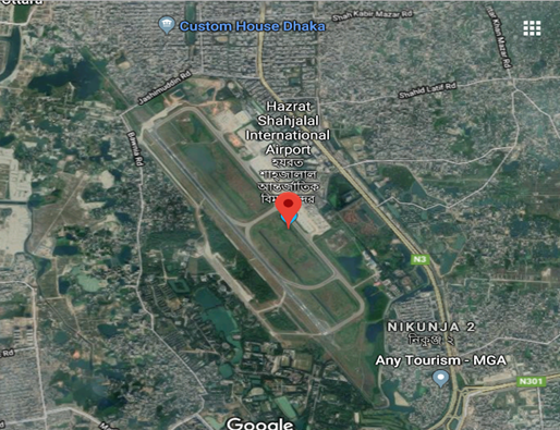
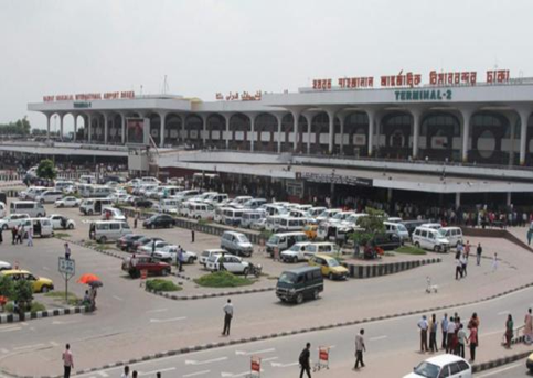
Introduction of HSIA
Hazrat Shahjalal International Airport is located in Dhaka City and offers good facilities to passengers as well as cargo traffic. The arrival section of the terminal is situated on the ground floor and the departure section on the first floor.
The airport has a separate domestic terminal, which is located adjacent to the international terminal. The airport has a separate cargo terminal named as the “Cargo Village”, managed by Bangladesh Biman. The airport has good access from the city with wide and well-maintained roads. The surrounding area of the airport was marshy till a few years back. The area has since being filled with sand and level has been made even with the runaway of the airport. At present various development and extension works are going on to improve the capacity and facilities of the largest airport of the country. It is being managed by the Director of the Airport alongwith his expert and experienced team members. For furthur details please go through the link:
https://en.wikipedia.org/wiki/Shahjalal_International_Airport
Airport Contact:
|
Name: Group Captain, Abu Sayeed Mehboob Khan, psc Address: Civil Aviation Authority of Bangladesh, Kurmitola, Dhaka-1229. |
Desig: Director, Hazrat Shahjalal International Airport Email: dhsia@caab.gov.bd |
Phone: +880 2 8901449 Fax (office): +880 2 8901450 |
General Information of HSIA
Airport Location Details
|
Location Details |
|||
|---|---|---|---|
|
Country |
Bangladesh |
Latitude |
235034N, Centre of the runway |
|
Province / District |
Dhaka |
Longitude |
0902402E, Centre of the runway |
|
Town or City (closest) |
Dhaka (Northern part) |
Elevation |
Elevation: 27ft (8m) |
|
Airfield Name |
Hazrat Shahjalal International Airport |
International airport |
Yes |
|
IATA & ICAO codes |
DAC / VGZR |
Open from/to (hours) |
Administration 0900 LT to 1700 LT Operational Services H24 |
Geographical and Administration Data
|
1. |
ARP* coordinates and site at AD* |
235034N, 0902402E; Centre of the runway |
|---|---|---|
|
2. |
Distance and direction from city |
11 NM (20 km) north of Dhaka City (GPO) |
|
3. |
AD elevation/reference temperature |
Elev: 27ft (8m) / T: 35decreeC (April) |
|
4. |
Magnetic variation |
55' West in 1967 (Annual change negligible) |
|
6. |
Type of traffic permitted |
IFR/VFR |
|
* ARP: Aerodrome Reference Point; AD: Aerodrome; APM: Airport Manager |
||
Airfield Infrastructure Details
|
Customs |
Yes |
JET A-1 fuel |
Yes |
Airport Radar |
Yes |
|---|---|---|---|---|---|
|
Immigration |
Yes |
AVGAS 100 |
Yes |
NDB |
Yes |
|
Terminal Building |
Yes |
Single Point Refueling |
Yes |
VOR |
Yes |
|
Passenger Terminal |
Yes |
Air Starter Units |
Yes |
ILS |
Yes |
|
Cargo terminal |
Yes |
Ground Power (mobile) |
Yes |
Approach Lights |
Yes |
|
Pax transport to airfield |
Yes |
Crash Crew |
Yes |
Fire Fighting Equipment |
Yes |
|
Control Tower |
Yes |
Aircraft Support Services |
Yes |
De-icing Equipment |
No |
|
Weather Facilities |
Yes |
Latrine Servicing |
Yes |
IFR Procedures |
Yes |
|
Catering Services |
Yes |
Fire Fighting |
Yes |
Runway Lights |
Yes |
|
Base Operating Room |
Yes |
Fire Fighting Category (ICAO) |
Category: VIII |
Parking Ramp Lighting |
Yes |
Runway Details
|
At present there is only one Runway in this Airport. Due to constant increase in air traffic the authority is planning to have a 2nd runway for HSIA. Meanwhile feasibility studies are also being carried out. Following are the details of the existing runway. |
||||
|
ID |
Dimensions |
Surface |
Strength (PCN) |
ILS |
|---|---|---|---|---|
|
14/32 (CAT-1ILS) |
10500 x 150 feet 3200 x 46 meters |
ASPHALT CONCRETE |
116/F/C/W/T |
YES |
Helicopter Pad(s)
For emergency operations, Bangladeshi Defense Forces use a lot of helicopters from HSIA also. The operational base for these movements is generally Tejgaon Military Airport, +/- 10 KM from DAC. Few of the Private Helicopters operate from the adjacent part of this Airport. They have their own hangers for these helicopters. In time of crisis Military Helicopters also use this portion of airport. List of the Helicopter Operating Companies along with their fleet size is shown at Art No 4.9 Page 491
Airport Performance
|
Performance |
Annual Figures |
Monthly |
Daily |
|---|---|---|---|
|
Total aircraft movements |
87,000 (Total landing and Taking off) |
7250 |
242 |
|
Total passengers |
8.4 M |
7,00.000 |
23333 |
|
Total Cargo handled (Year 2017-2018) |
3,66,019 MT (Export and Import) |
30502 MT |
1017 |
|
Total capacity of the airport (MT) daily |
150 MT |
n/a |
n/a |
|
Current activity of the airport (MT) daily |
100 MT |
n/a |
n/a |
|
Current use by Humanitarian flights (UNHAS) |
As and when required depending on the situation |
||
Airport Operating Details
|
Max size aircraft that can be offloaded on bulk cargo |
Boeing 747 (100MT Cargo)/ AN-124/ Boeing 777 |
|---|---|
|
Max size cargo aircraft that can be offloaded on pallet |
Boeing 747 (100MT Cargo)/ AN-124/ Boeing 777 |
|
Total Parking Area |
99,000 m² |
|
Storage Area |
27,800 m² |
|
Cargo Handling Equipment |
Yes |
|
Elevators / Hi-loaders |
Yes |
|
Can Hi-loader/Elevators reach the upper deck of B747/777? |
Yes |
|
Loading Ramps |
Yes |
Terminal Facilities
The terminal facilities of HSIA contain 1 floor domestic passenger terminal building, 3 floors international passenger terminal building, 1 floor domestic/international cargo terminal building, VVIP terminal building, infrastructure supply facility, management/office building. Related facilities are independent in the terminal area. There are 2 terminals i.e. terminal 1 and terminal 2 for the international passengers which are connected. These 2 terminals share same departure lobby and departure gates. The existing international passenger terminal 1 and terminal 2 which are in the same building with floor area of 73,400 m2 and Domestic Passenger Terminal 2,200 m2. Soon construction of the 3rd terminal will start under the consultancy of JAICA at the cost of BDT 136.10 billion, which is expected to be completed by 2022. Apart from a 226,000-square meter terminal building, a new cargo village, VVIP complex, and rapid exit, connecting taxiways and an oil depot will be constructed under the project. After construction of the third terminal, passenger handling capacity will increase to 20 million and cargo handling capacity to 500,000, according to the CAAB.
Other Operational Details
|
Rescue and Fire Fighting Services |
|||||||||||||||||||||||
|---|---|---|---|---|---|---|---|---|---|---|---|---|---|---|---|---|---|---|---|---|---|---|---|
|
1. |
AD category for firefighting: |
Required category VIII, available category VIII. Facilities available for foaming runway. |
|||||||||||||||||||||
|
2. |
Rescue equipment available: |
To meet ICAO requirement for category VIII. |
|||||||||||||||||||||
|
3. |
Disable aircraft removal: |
||||||||||||||||||||||
|
|||||||||||||||||||||||
|
4. |
Remarks |
N/A |
|||||||||||||||||||||
|
Seasonal Availability Clearing |
|---|
|
The airport is available for all seasons. Side strips become unusable during monsoon. There is no requirement for clearing. |
|
Aprons, Taxiways and Check Location Data |
||
|---|---|---|
|
1. |
Apron surface and strength |
Surface : Concrete. |
|
2. |
Taxiway width, surface and strength |
Width : 23 m. |
|
3. |
ACL Location |
Not designated |
|
4. |
INS checkpoints |
Nil |
|
5. |
Remarks |
Nil |
|
Surface Movement Guidance, Control System and Markings |
|
|---|---|
|
Use of aircraft stand ID signs, TWY guidelines and visual docking/ parking guidance system of aircraft stands |
Taxiing guidance signs at all intersections with TWY and RWY at
all holding positions, |
|
RWY and TWY markings and LGT |
RWY: 14/32. |
|
Stop Bars |
N/A |
|
Aerodrome Obstacles |
|
|---|---|
|
In approach/Take-off areas |
In circling area and at aerodrome |
|
Consult AOC type-A, HSIA, Page VGHS AS 2-16 |
Obstruction in the circling area are shown on the instrument approach chart and page VGHS AD 2-11 |
|
Meteorological Information Provided |
||||||||
|---|---|---|---|---|---|---|---|---|
|
1. |
Associated Met office |
HSIA (VGHS) |
||||||
|
2. |
Hours of service |
H24 |
||||||
|
3. |
Office responsible for TAF preparation and Periods of validity |
HSIA (VGHS); 6,12 |
||||||
|
4. |
Type of landing forecast Interval of issuance |
TREND |
||||||
|
5. |
Briefing/consultation provide |
P, D, T |
||||||
|
6. |
Flight documentation and Languages used |
C, PL; English |
||||||
|
7. |
Charts and other information available for briefing or consultation |
S,U |
||||||
|
8. |
Supplementary equipment available for providing information |
WXR |
||||||
|
9. |
ATS units provided with information |
Dhaka ACC/FIC; APP; TWR |
||||||
|
10. |
Additional information |
Tel: 880-2-8914543 (Met office) |
||||||
|
Runway Physical Characteristics |
||||||||
|
Designator RWY NR |
True & MAG BRG |
Dimensions of RWY (m) |
Strength (PCN) and surface of RWY & SWY |
THR coordinates |
THR ELEV and highest ELEV of TDZ of PAR |
Slope of RWY-SWY |
||
|
14 |
144 deg True |
3200x46 |
59/F/B/W/T |
235118.11N |
27 |
nil |
||
|
32 |
324 deg True |
3200x46 |
59/F/B/W/T |
234954.00N |
27 |
nil |
||
|
Designator RWY NR |
SWY dimensions (m) |
CWY dimensions (m) |
Strip dimensions (m) |
OFZ |
Remarks |
|||
|
14 |
275x46 |
275x153 |
3750x153 |
Within the CWY. |
25 ft (8 m) brick soling with bitumen carpeting shoulder at both side of RWY. |
|||
|
32 |
275x46 |
275x153 |
3750x153 |
|||||
|
Declared Distances |
|||||
|---|---|---|---|---|---|
|
RWY |
TORA (m) |
TODA (m) |
ASDA (m) |
LDA (m) |
Remarks |
|
14 |
3200 |
3475 |
3475 |
3200 |
N/A |
|
32 |
3200 |
3475 |
3475 |
3200 |
N/A |
|
RWY:Runway; TORA:Take-off run available; TODA:Take-off distance
available; |
|||||
|
Approach and runway lighting |
|||||||||
|---|---|---|---|---|---|---|---|---|---|
|
RWY designator |
APCH LGT type |
THR LGT color WBAR |
VASIS (MEHT) PAPI |
TDZ LGT LEN |
RWY centre line LGT |
RWY edge LGT LEN, spacing, color INTST |
RWY end LGT color WBAR |
SWY LGT |
Rem |
|
14 |
Precision approach CAT-I lighting system Simple approach lighting system and sequenced flashing lights Supplementary approach |
Green supple-mented by green Wingbar |
PAPI 3 deg |
available |
available |
60 m apart white omni-directional with intensity 3%, 10%, 30%, 80%, 100% |
Red unidirectional Green omnidirectional |
available |
nil |
|
32 |
Simple approach lighting system |
Green supple-mented by green Wingbar |
PAPI 3 deg |
available |
available |
60 m apart white omni-directional with intensity 3%, 10%, 30%, 80%, 100% |
Red unidirectional Green omnidirectional |
available |
nil |
|
Other Lighting, Secondary Power Supply |
||||
|---|---|---|---|---|
|
1. |
ABN/IBN location, characteristics and hours of operation |
ABN: 235057.20N 0902413.24E Over Control TWR) |
||
|
2. |
LDI location and LGT |
Nil |
||
|
3. |
TWY edge and centre line lighting |
Edge: Blue edge lgts for all TWYs |
||
|
4. |
Secondary Power Supply/ Switchover time |
During main power supply failure, Automatic standby generator power supply available for Apch, RWY, TWY and Apron lighting within 15 seconds |
||
|
5. |
Remarks |
APRON LIGTHS: High Intensity Flood Lights |
||
|
ATS Airspace |
||||
|
Designation |
Dhaka Control Zone |
|||
|
1. |
Lateral limits |
A circle of 25 NM radius central on Dhaka VOR (234928.86N 0902445.36E) except that portion which falls north of the strait line joining points 241147N 0903550E and 241147N 0901350E |
||
|
2. |
Vertical limits |
GND to FL055 |
||
|
3. |
Airspace |
C |
||
|
4. |
ATS unit call sign/ Language |
Dhaka Tower/ English |
||
|
5. |
Transition altitude |
4000 ft MSL |
||
|
6. |
Remarks |
Nil |
||
|
Designation |
Aerodrome Traffic Zone (ATZ) |
|||
|
1. |
Lateral limits |
ATZ is oval shaped area joining outer tangents of 5 NM (9 km) radius circles centered at the runway centre and both ends of runway |
||
|
2. |
Vertical limits |
4000 ft |
||
|
3. |
Airspace |
C |
||
|
4. |
ATS unit call sign/ Language |
Dhaka Tower/ English |
||
|
5. |
Transition altitude |
4000 ft MSL |
||
|
6. |
Remarks |
Nil |
||
|
ATS Communication Facilities |
||||
|---|---|---|---|---|
|
Service designator |
Call sign |
Frequency |
Hours of operation |
Remarks |
|
Area Control (ACC) |
Dhaka Tower |
125.7 MHz |
H24 |
Emergency frequency 121.5 MHz |
|
TWR (Aerodrome and Approach Control, Non-Radar) |
Dhaka Tower |
118.3 MHz |
H24 |
EM: A3 |
|
APP (Radar/Non-Radar) |
Dhaka Approach |
121.3 MHz |
0130-1400 daily except Saturday; 0800-1400 on Saturday |
Emergency frequency 121.5 MHz. |
|
Radar |
Dhaka Radar |
126.7 MHz |
HO |
Only monitoring service is provided on request. |
|
SMC |
Dhaka Ground |
121.8 MHz |
H24 |
N/A |
|
Air-Ground |
Dhaka Radio |
3491, 6556, 10066, 2947 kHz |
H24 |
MWARA (3491, 6556, 10066 kHz) |
|
ATIS |
Dhaka Information |
127.4 MHz |
H24 |
N/A |
|
Note: During OJT (on the job training) in TWR, APP (Non-Radar), ACC or Radar Approach Control Service at HSIA will be Ltd. However, Radar Approach Control Service may be available during OJT on request. |
||||
|
Radio Navigation and Landing Aids |
|||||
|---|---|---|---|---|---|
|
Type |
Ident |
Freq |
OpHr |
Coordinates |
Remarks |
|
DVOR |
DAC |
112.7 MHz |
H24 |
234928.86N |
144 deg MAG, 958m FM THR RWY 32, EM:A2 |
|
DME |
|
1161 MHz |
H24 |
234928.86N |
Collocated with DVOR, Elev of Antenna 49ft AMSL, EM:P9 |
|
NDB |
DCN |
298 kHz |
H24 |
235034.32N |
046 deg MAG, 1795m fm THR RWY32, EM:A2 |
|
ILS/LLZ |
IDA |
109.5 MHz |
H24 |
234940.04N |
144 deg MAG, 550m FM THR RWY 32, EM:A2 |
|
ILS/GP |
|
332.6 MHz |
H24 |
235112.67N |
Slope: 3 deg, 130 m off-set East, 300 m inward fm RWY 14, RDH 51.57 ft, EM:A3 |
|
MM |
|
75 MHz |
H24 |
235145.75N |
324 deg MAG, 1050m FM THR RWY 14, EM:A2 |
|
OM |
DA |
75 MHz |
H24 |
235557.71N |
324 deg MAG, 5.8NM FM THR RWY 14, EM:A2 |
|
OL |
|
375 kHz |
H24 |
235558.39N |
324 deg MAG, 5.8NM FM THR RWY 14, EM:A2 |
Bird Concentration
Bird concentrations may exist on or in the vicinity of HSIA due to low laying area around the airfield, during the period from December to May of the year. Bird shooters are posted in the maneuvering area to reduce the bird hazard. Moreover, necessary information about the location of birds, if visible, is transmitted to the pilots by Aerodrome Control Tower. However, pilots are requested to exercise caution while approaching to land and take-off.
Cargo Handling Procedure and Storage Facilities
Both inbound and outbound cargo are carefully and systematically handled by the cargo division of Bangladesh Biman. Import Terminal is used for handling inbound cargo and a separate terminal known as Cargo Village is used for exporting cargo through HISA. Sufficient Cargo handling equipment facility is being managed by GSE division of Bangladesh Biman.
Import Cargo Terminal
- There is a 2 storied Import Terminal and a concrete structured warehouse area with direct access to apron.
- Cargo operations are owned and controlled by Bangladesh Biman (National Carrier).
- Concrete floor space of 15,000m² area.
- Landside loading / offloading area provided.
- 2 nominal aircraft parking spots in front of building.
- Total warehousing area is insufficient and therefore, mostly the imported cargo remains in the open air on the concrete ground.
Export Cargo Terminal
- The Cargo Export terminal is called Cargo Village situated on the northern side of the Airport.
- The complex is separated from Import Cargo terminal and has direct access to apron.
- Cargo operations are owned and controlled by Bangladesh Biman.
- Concrete floor space of 12,800m².
- Landside loading / offloading area provided.
- nominal aircraft parking spots are there in front of building.
Handling Services and Facilities
Biman Bangladesh Airlines (BB) is given the responsibility of handling the total Cargo services including proving General Service Equipment as required. At present they have following handling equipment which seems to be in sufficient for managing cargo in time of crisis or special operation:
|
Sl |
Description |
Qty |
|---|---|---|
|
1 |
Water Cart |
03 |
|
2 |
Air Start Unit |
05 |
|
3 |
Air Conditioning Unit |
02 |
|
4 |
Ambulift |
02 |
|
5 |
Belt Loader |
11 |
|
6 |
Mobile Cranes |
01 |
|
7 |
Container Pallet Loaders |
13 |
|
8 |
Catering Hi-Lift |
06 |
|
9 |
Container Pallet Transporters |
08 |
|
10 |
Delivery Van |
01 |
|
11 |
Flush Cart |
02 |
|
12 |
Fork Lift |
07 |
|
13 |
Fuel Brouser |
01 |
|
14 |
Ground Power Unit |
18 |
|
15 |
Narrow Asle Stacker |
11 |
|
16 |
Push Back Tow Tractor |
07 |
|
17 |
Passenger Steps |
08 |
|
18 |
Ramp Coach |
07 |
|
19 |
Tow Tractor Baggage |
37 |
|
Total |
150 |
|
Ground Handling Agency
Biman provides ground handling facilities to all airports in Bangladesh and is approved by the Civil Aviation of Bangladesh, as the sole ground handler to all foreign carriers’ flights operating on commercial basis. It has sufficient ground handling equipment and experienced manpower to handle all type of aircraft.
All schedule/non-schedule operators may contact with the following address to get the latest information related to ground handling at any Bangladeshi airport:
List of Officers - Biman Bangladesh Airlines
| Name | Designation | Phone | Mobile | |
|---|---|---|---|---|
| Capt. Farhat Hassan Jamil |
Managing Director & CEO |
+88-02-8901700 |
01777715501 |
|
| Ziauddin Ahmed |
Director, Administration |
+88-02-8901701 |
01777715506 |
|
| Kazi Atiqur Rahman |
Company Secretary |
02-8901383 |
01777715510 |
|
| Nurul Islam Howlader |
GM, Airport Services |
+88-02-8901550 |
01777715531 |
|
| Md. Atique Sobhan |
General Manager, Customer Services |
+88-02-8901770 |
01777715532 |
|
| Shahnoor Ahmad |
DGM, Ground Service |
+88-02-8901303 |
|
|
| Md. Rashedul Karim |
General Manager, Ground Support Equipment |
+ 88-02-8901২93 |
01777715552 |
|
| Md Shamsul Karim |
DGM, Transport Department |
+88-02-8901532 |
01777715550 |
Cargo Import Export Procedure
Import Procedure
- Cargo received from Aircraft (along with Air Waybill and Cargo manifest).
- Then they are segregated, sorted and stored at the warehouse by Ground Cargo Handler (BB)
- As per AWB the Consignee is informed/ Consignee goes to Cargo office.
- Consignee/ their authorized C&F agent collects AWB and goes to Customs authority
- Customs puts a Rotation Number, Examine the goods for Tax/Waiver/unauthorized goods etc.
- Upon examination Customs authority provides clearance to release Goods.
- At the cargo yard (Import) after payment of the Handling charges or Storage charges (if any) the goods are delivered to the agent.
- The C& F agent will make transportation arrangements beyond airport.
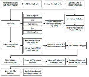
Export Procedure
- Exportable Cargo to be delivered to the Cargo Village of BB
along with following:
- Cargo well packed and marked with Labels
- Invoice
- Packing List
- Customs Clearance Certificate for export (Ex BOE)
- Gate Pass mentioning the AWB number.
- Cargo received at the Acceptance area by BB where items will be measured and AWB will be prepared.
- FF agent will then send all documents to Customs for final clearance and payments etc.
- On receiving final clearance from Customs cargo will be Scanned by Duel view scanning machine (total having 6) and for EU countries by EDS machine (total having 2).
Once cargo is checked, it is sent to Loading area for Export.
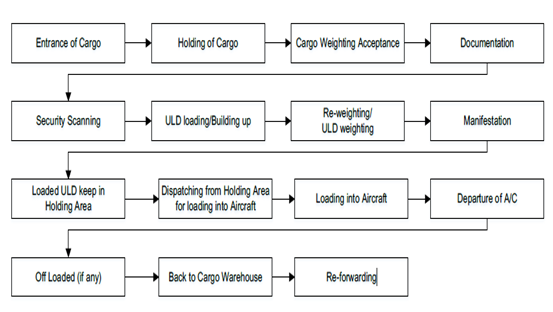
Airport Charges and Fees (As of 2019)
The charges set out are common to all Civil Aviation Authority administered aerodromes except where the contrary is stated.
Unless an alternative arrangement has been made, all charges for use of aerodromes are payable by the pilot of the aircraft on demand or before the aircraft departs from the aerodrome.
Fees shall be paid to the Chairman, Civil Aviation Authority and if not so paid shall be a debt due to Government of Bangladesh from the owner and the Commander of the aircraft in respect of which the fees are payable.
For the purpose of enforcing payment of fees, the Chairman, Civil Aviation Authority may refuse to permit and aircraft to take off from an aerodrome until all fees have been paid.
No abatement of any fees shall be allowed in the event of any aerodrome service, assistance or other facility being not available and except as provided in these Regulations no exemption or remission shall be granted.
Exemption
Landing Charges, Parking and Housing Charges, Boarding Bridge Fees, Security Charges, Charges for flights beyond hours of operation and Route Navigation Charges shall not be applicable in the following cases, namely:
- An aircraft belonging to the United Nations Organization or any of its agencies or International Red Cross engaged in medical relief for humanitarian mission
- An aircraft engaged on non-remunerative basis in search and rescue operations or medical relief or humanitarian mission
- Any aircraft engaged in air calibration work;
- An aircraft belonging to Flying Clubs approved by CAAB engaged in training purpose;
- State aircraft of Bangladesh;
- Such aircraft as the Government may deem fit to exempt.
Navigation Charges (US$)
|
MTOW (Maximum Take-Off Weight) in the Certificate of Airworthiness |
International flight |
Domestic flight |
|---|---|---|
|
Not exceeding 2,000 kg |
BDT equivalent of USD 12 |
BDT 75 |
|
Over 2,000 kg but not exceeding 5,000 kg |
BDT equivalent of USD 24 |
BDT 150 |
|
Over 5,000 kg but not exceeding 10,000 kg |
BDT equivalent of USD 30 |
BDT 225 |
|
Over 10,000 kg but not exceeding 20,000 kg |
BDT equivalent of USD 75 |
BDT 450 |
|
Over 20,000 kg but not exceeding 50,000 kg |
BDT equivalent of USD 150 |
BDT 900 |
|
Over 50,000 kg but not exceeding 100,000 kg |
BDT equivalent of USD 300 |
BDT 1800 |
|
Over 100,000 kg but not exceeding 200,000 kg |
BDT equivalent of USD 420 |
BDT 3000 |
|
Over 200,000 kg |
BDT equivalent of USD 450 |
BDT 3750 |
Landing Charge
Basis: MTOW (Maximum Take-Off Weight) in the CoA (Certificate of Airworthiness).
The charges for landing an aircraft at Government Airports / Aerodromes are as follow:
|
Total weight of the Aircraft as provided in the certificate of airworthiness |
Single Landing charges (Calculated nearest 1000 kg.) |
|
|---|---|---|
|
International flights |
Domestic flights |
|
|
Not exceeding 10,000 kg |
Such amount of BDT as is equivalent to US$ 5.25 per 1000 kg. |
BDT 53 per 1000 kg. |
|
Over 10,000 kg. but not exceeding 20,000 kg |
Such amount of BDT as is equivalent to US$ 6.75 per 1000 kg. |
BDT 68 per 1000 kg |
|
Over 20,000 kg. but not exceeding 50,000 kg. |
Such amount of BDT as is equivalent to US$ 7.5 per 1000 kg. |
BDT 83 per 1000 kg |
|
Over 50,000 kg. but not exceeding 1,00,000 kg |
Such amount of BDT as is equivalent to US $9.75 per 1000 kg. |
BDT 150 per 1000 kg. |
|
Over 1,00,000 kg. but not exceeding 3,00,000 kg |
Such amount of BDT as is equivalent to US $12 per 1000 kg |
BDT 188 per 1000 kg. |
|
Over 3,00,000 kg |
Such amount of BDT as is equivalent to US $ 12.75 per 1000 kg |
BDT 315 per 1000 kg. |
- The charges may also be paid in US Dollars.
- 10% extra charge for each landing or take-off after sunset and before sunrise.
- Only 50% of the landing charges, in case the aircraft is engaged in training purpose.
- In case an aircraft is engaged in test flight only, with the approval of the Airport Manager, only 25% of the landing fees will be charged.
Parking and Housing Charges
- Parking charges for each 24 hours period or part thereof: 25% of the landing charges when the parking period exceeds 6 hours;
- Hangar charges for each 24 hours period or part thereof: 50% of the parking charges;
- Monthly charges for both parking and hangar: 20 times the 24 hours parking / hangar charge
- Quarterly charges for both parking and hangar: 50 times the 24 hours parking / hangar charge
- Without written approval the Chairman CAAB, no aircraft shall be allowed to stay on the apron for more than 3 months.
Boarding Bridges Fees
- Hourly rates for using the Boarding Bridge:
|
Rate for the first two hours (on hourly basis) All up weight of aircraft (kg) |
Charge (US$) |
|---|---|
|
Below 100,000 |
100 |
|
From 100,000 to below 200,000 |
150 |
|
From 200,000 to below 300,000 |
200 |
|
300,000 and above |
250 |
- Basic Boarding Bridge charges as mentioned above are applicable for the first two hours only.
- If an aircraft uses Boarding Bridges for more than two hours, the rate for each additional half-an-hour, or part thereof, shall be as follows:
|
All up weight of aircraft (kg) |
Charge (US$) |
|---|---|
|
Below 100,000 |
60 |
|
From 100,000 to below 200,000 |
75 |
|
From 200,000 to below 300,000 |
90 |
|
300,000 and above |
125 |
Discount in additional charges at Hazrat Shahjalal International Airport
- If the period of the additional use of the Boarding Bridge the Airport is not in conceding with the busy hours of operation, the applicable rates shall be only 50% of the rates mentioned above.
- The right definition of the hours of operation at the airport as busy or non-busy lies with the Civil Aviation Authority. The timing will be circulated to the operators at the time of approving the schedule and may be amended from time to time.
- The period of use of Boarding Bridge shall be reckoned from the time an aircraft docks in, to the time the aircraft starts pushing back.
- Discount for frequent users
- Discount Charge for the frequent users of Boarding Bridges shall be as follows:
|
Hours used weekly |
Rate |
|---|---|
|
61 to 90 hours |
5% |
|
91 to 120 hours |
7.5% |
|
121 hours and above |
10% |
|
Note: The hours mentioned above are cumulative. |
|
Charges for flight Beyond Hours of Operation
The charges for utilizing airport or aerodrome facilities and air route navigation facilities for flights operating beyond hours of operation:
|
For use of airport or aerodrome facilities
|
International Flights |
The amount of BDT equivalent to US $ 225 per hour or part thereof. |
|---|---|---|
|
Domestic Flights |
BDT 4500 per hour or part thereof. |
|
|
For use of air route navigation facilities |
|
The amount of BDT equivalent to US $ 90 per hour or part thereof. |
Cargo Terminal Charges
|
Import |
Rate US$/kg |
|---|---|
|
Import storage charge |
03 days free |
|
Cargo and Mail Handling Charge for skd |
0.07 US$ per Kg |
|
Cargo and Mail Handling Charge for non skd |
0.10 US$ per Kg |
|
Dangerous goods handling fee for import |
US$ 100 |
|
Live animal handling fee for import |
10 US$ per AWB |
|
Forklifts charge for import |
3 BDT per Kg |
|
Cool room storage charges |
1-7 days: BDT 50 per unit of 50 Kg 8-14 days: BDT 100 per unit of 50 Kg 14 + days: BDT 600 per unit of 50 Kg |
|
Strong room storage charges (3 days free) |
03-13 days 50 BDT/ Unit (Per Unit 50 kg) 13-21 days 200 BDT/ Unit (Per Unit 50 kg) 21+ days 600 BDT/ Unit (Per Unit 50 kg) |
|
Import handling fee |
5 BDT/ kg |
|
Export |
Charges |
|
Security escorting charges for VAL cargo (on request) |
US $ 100 |
|
Export Storage Charge |
30 hours free |
|
Terminal handling charges |
0.08 US$/Kg |
|
Cargo and Mail Handling charge for skd |
0.08 US$/Kg |
|
Cargo and mail handling charge for non skd |
0.10 US$/Kg |
|
Security Scanning Charge (CAAB) |
0.06 US$/Kg |
|
Reweighing charge for export (On request) |
US$ 10 per AWB |
|
Dangerous goods handling fee for export |
US$ 100 |
|
Live animal handling fee for export |
10 US$ per AWB |
|
Forklift charge for export |
BD BDT 3/ Kg |
|
Full airways bill data transmission (FWB) |
5 US$ per AWB |
|
House airway bill data transmission (FHL) |
5 US$ per AWB |
|
RA3 handling charge for export |
0.02 US$ Kg |
Charges for Passenger Boarding Bridge (PBB)/ Air-bridge / Sky Bridge/ Jet Bridge
- Hourly rates for using Boarding Bridge at all airports or aerodromes of Bangladesh shall be as follows:
|
All up weight of the aircraft (kg.) |
Charges (US$) |
|---|---|
|
Below 100,000 |
100 |
|
From 100,000 to below 200,000 |
150 |
|
From 200,000 to below 300,000 |
200 |
|
300,000 and over |
250 |
- Basic boarding bridge charges as mentioned in clause A shall apply for the first 2 (two) hours only.
- If an aircraft uses Boarding Bridge for more than 2 (two) hours, the rates for each additional half-an-hour, or part of thereof, shall be as follows:
|
All up weight of the aircraft (kg.) |
Charges (US$) |
|---|---|
|
Below 100,000 |
60 |
|
From 100,000 to below 200,000 |
75 |
|
From 200,000 to below 300,000 |
90 |
|
300,000 and over |
125 |
- If the period of additional use of the Boarding Bridge at Hazrat SHahjalal International Airport is not in Busy hours of operation, the applicable rates shall be 50% of the rates mentioned in clause C.
- The right for edclaration of the hours operation at Hazrat Shahjalal International Airport as busy or non-busy lies with the Civil Aviation Authority. The timing will be circulated to the operators at the time of approving the schedule and may be amended from time to time.
- the period for the use of Boarding Bridge shall be reckoned from the time an aircraft docks in, to the time the aircraft starts to push back.
- Discount Charges for the frequent users of Boarding Bridges shall be as follows:
|
Hours Used Weekly |
Rates of Discount |
|---|---|
|
61 - 90 Hours |
5% |
|
91 - 120 Hours |
7.5% |
|
121 Hours and above |
10% |
|
The hours mentioned above shall be cumulative. |
|
Humanitarian Staging Area (HSA)
In fact, the present cargo storage facilities of the airport are insufficient, and the authority is facing tremendous problems to support the exporters and importers in their regular operations. So, it will be very difficult to handle huge influx of imported cargo in time of crisis. Considering the fact, the government of Bangladesh has decided to allocate a piece of land at Purbachal area (approx. 15 KM south-east of Airport). This will be known as “Humanitarian Staging Area” to be developed by WFP Bangladesh in collaboration with the Ministry of Disaster Management and Relief (MoDMR) which will be used by the UN and other humanitarian organizations and NGOs for managing their humanitarian cargo. The area is well connected by road and new extension of the town is going to be established there in near future. Suitable numbers of sheds and warehouses will be built in the area and cargo will be directly transported from airport to this area for sorting, storing and transporting for subsequent distributions.
Development Projects
Recently Completed Development Works:
- Extension of passenger apron from foxtrot taxiway towards west and export cargo apron from northern side of the existing export cargo apron at Hazrat Shahjalal international airport, Dhaka.
- Asphalt concrete overlay over the existing runway at Shahjalal international airport, Dhaka.
- Upgrade of Hazrat Shahjalal international Airport, Dhaka.
- Consultancy Services for the Up gradation of Hazrat Shahjalal International Airport, Dhaka.
- Consultancy services for Construction of 3rd Terminal, 2nd Runways and other infrastructure Development Works at Hazrat Shahjalal International Airport, Kurmitola, Dhaka.
On Going Development Works:
- Consultancy and delivery of services for improvement of security system at Hazrat Shahjalal international Airport, Dhaka.
- Construction of CAAB Headquarters Complex at Hazrat Shahjalal International Airport, Kurmitola, Dhaka.
- Extension of apron towards north of the existing export cargo apron at Hazrat Shahjalal international Airport, Dhaka (Phase-11).
- Construction of General Aviation Hangar, Hangar Apron & Apron North side of fire station at Hazrat Shahjalal international Airport, Dhaka.
- Construction of 3rd Terminal, at Hazrat Shahjalal International Airport, Kurmitola, Dhaka.
Future Development Works:
- Hazrat Shahjalal International Airport, Dhaka Expansion Project.
Fuelling Arrangement at HSIA
Padma Oil Company under the supervision of Bangladesh Petroleum Corporation (BPC) is solely responsible for providing fuel to all kinds of Aircraft at HSIA. It is located at Kurmitola adjacent to the HSIA airport. Few salient features of this Aviation fuel provider are below:
|
Description |
Arrangement |
|---|---|
|
Type of Fuel |
Jet A1 and AV Gas (F gas 100LL) |
|
Tanks with Capacity |
Jet A1 - 12 Tanks with total 8500 MT storage capacity. AV Gas- approx. 600 drums (as per requirement) |
|
Requisition for Fuel |
Written requisition with Payment be placed in advance |
|
Hydrant lines |
Approx 4 KM Hydrant pipe lines are laid from depot to airport area with 21 fueling points against 29 bay. |
|
Fueling arrangement |
Fueling is done by 11 Dispenser and 7 refuelers having tank capacity of 18,000 ltrs each. |
|
Consumption |
Yearly approx. 40,000 MT (Daily avg 1,000 MT) |
|
Price of Jet A1 |
BDT 75/00 and $ 0.72 per ltr |
|
Safety |
Ensured by IATA and JIG |
|
Tech assistance |
Provided by SHELL |
Contact Details
|
Md Mahbubul Alam DGM (Aviation) Depot In-Charge |
Shahjalal Service Station Hazarat Shahjalal Int Airport, Kurmitola, Dhaka, Bangladesh |
Cell No: 01777703324 |
Security Arrangement
A Security Director, with Chief Security Officers assisting him at various airports, heads the security function in CAAB. The Chief Security Officers at the respective airports are directly responsible for the security there. Apart from this security is also provided by the Government of Bangladesh since airports fall under sensitive installations of the country. Armed security personnel drawn from various agencies of the government are deployed at the entrances to the airports as well as on the runways and parking bays. No serious lapses in security have been reported which is an indicator that security measures at all airports in Bangladesh are quite adequate. In short the Airport is well secured with the presence of significant number of Security personnel. Few salient points are narrated:
- A total of 2,000+ Police, Armed Police, and other Security personnel are maintaining Access Control, Immigration, Security Checks and Intelligence of the Airport.
- Security personnel are under the control of the airport director.
- A dedicated police station exists at the airport.
- All access points are guarded by security personnel.
- Due to proximity of Bangladesh Military installations, RAB and Armed Police Bn, a large number of Security Personnel’s presence can be drafted in to support policing if required.
- X-Ray screening for both passengers and cargo is in use.
- Contingency plans are in place.
- No additional forces should be required following a disaster.
Security charge
The charges for security checking of embarking passengers and their hand-carried bags, wherever provided, are as follows.
|
International flights: |
10% of the day time landing charges, minimum the amount of BDT equivalent to US $ 100 per departing aircraft. |
|---|---|
|
Domestic flights: |
10% of the day time landing charges, minimum 250 BDT per departing aircraft. |
For information on Bangladesh Zia Dhaka International Airport contact details, please see the following link:
4.5 Bangladesh Airport Contact List
For additional information, please see the following documents:
Bangladesh Costs 2013 Airfield Charges
Note: The information provided in the attached documents, which has been taken from the old DLCA, does not match the structure of the new LCA and is therefore provided separately.
Information on some aviation service providers can be found at: AZ Freight information on Bangladesh
2.2.3 Bangladesh Osmani International Airport
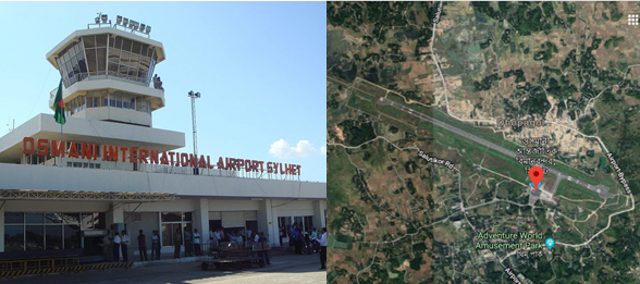
Airport Overview
| Location Details | |||
|---|---|---|---|
| Country | Bangladesh | Latitude | 24.96333 |
| Province / District | Sylhet | Longitude | 91.86694 |
| Town or City (Closest) |
Sylhet 5 NM N of Sylhet Town |
Elevation (ft and m) | 50 ft / 15.24 m |
| Airfield Name | Osmani International Airport | IATA and ICAO Codes | VGSY / ZYL |
| Open From (hours) | 6:00 | Open To (hours) | 21:00 |
Sylhet is a major city in north-eastern Bangladesh. It is the main city of Sylhet Division and District and was granted metropolitan city status in March 2009. Sylhet is located on the banks of the Surma River and is surrounded by the Jaintia, Khasi and Tripura hills. The city is approaching a population of 500,000 people while also having a high population density. It is one of the largest cities in Bangladesh. The Sylhet region is well known for its tea gardens and tropical forests, the city however is currently known for its business boom – being one of the richest cities in Bangladesh, with new investments of hotels, shopping malls and luxury housing estates, brought mainly by expatriates living in the United Kingdom. The city of Sylhet is served by Osmani International Airport, located at the north of the city.
Osmani International Airport, Sylhet was built in 1944-1945, during the 2nd World War to check Japanese aggression from Burma. The airport was formerly known as Sylhet Civil Airport. The airport was initially served by domestic flights from Shahjalal International Airport by the country's national airline Biman Bangladesh Airlines Ltd. After that Sylhet Civil Airport was renamed as Osmani International Airport (OIA) in the honour of General M A G Osmani, the Chief of Liberation Forces of Bangladesh and a proud son of the soil of Sylhet division.
In 1986, the airport became a full-fledged domestic airport after the construction of terminal building, installation of navigational aids, re-construction of runway pavement, development of taxiways and aprons under the project of Sylhet Civil Airport. After many years in 1998 Ltd expansion of the airport was carried out to enable medium-sized aircraft, such as the Airbus A310. In 2002 the airport was designated an International airport by the government, and it received the first international arrival flight of Biman Bangladesh Airlines Ltd. However, the airport was not up to international standards due to shortage of equipment.After the South Asia Transport and Trade Facilitation Conference in 2006, upgradation work of terminal facilities to enable handling of international flights work was started. The improvements included construction of a new terminal building, two Jetways and a taxiway and after the completion of work Biman would operate Hajj flights directly from the airport during the Hajj season in 2007.In 2010 the decision was made to construct a refuelling station and the work began in 2012. In 2015, Fly Dubai the 1st foreign airlines operated their flight to Sylhet from Dubai. Osmani International Airport is located at 15 km north-east from Sylhet city. At present domestic and international passenger and cargo flights are operating by the national and international airlines operators to and from Osmani International Airport, Sylhet. It is one of the most clean and hygienic Airport which is well maintained regularly.
|
Airport Operations Manager |
Custom |
Handling Operations / Logistics |
|---|---|---|
|
Airport Manager Cell: 01708167287 PABX: 880821- 725391 to 94 |
Assistant Commissioner of Customs Airport custom House Tel: 0821- 717356 |
Biman Bangladesh Airlines: |
General Information of OIA
Runway Details
|
Description |
Runway 11 |
Runway 29 |
|---|---|---|
|
Surface |
ASPHALT |
ASPHALT |
|
True Heading |
113.00 |
293.00 |
|
Latitude |
24.968336 and 24° 58' 06.01" N |
24.958147 and 24° 57' 29.33" N |
|
Longitude |
91.853617 and 091° 51' 13.02" E |
91.879953 and 091° 52' 47.83" E |
|
Elevation/Slope |
50.0 feet (15 meters)/0 |
50.0 feet (15 meters)/ 0.0° |
|
Landing Distance |
8458 feet (2578 meters) |
9478 feet (2889 meters) |
|
Take off Distance |
9678 feet (2950 meters) |
9478 feet (2889 meters) |
|
Displaced Threshold Length |
1020 feet (311 meters) |
- |
|
Overrun Length |
200 feet (61 meters) |
- |
|
Overrun Surface |
ASPHALT |
ASPHALT |
|
Lighting System |
PAPI LIGHTS |
PAPI LIGHTS |
|
SWY dimensions |
61x46 m |
300x46 m |
|
CWY dimensions |
153 m |
300 m |
|
Strip dimensions |
2952x153 m |
2952x153 m |
|
SWY surface and strength: First 80FT same as RWY, Remaining 120FT is nominal concrete. |
||
Airfield details
|
Customs (HO) |
Yes |
JET A-1 fuel |
Yes |
|---|---|---|---|
|
Immigration (HO) |
Yes |
AVGAS 100 |
No |
|
Terminal building |
Yes |
Single point refuelling |
No |
|
Passenger terminal |
Yes |
Starter units (press air) |
Yes |
|
Cargo terminal |
No |
Ground power (mobile) |
Yes |
|
Pax transport to airfield |
Yes |
Crash crew |
Yes |
|
Control tower |
Yes |
Aircraft support services |
Yes |
|
Weather facilities |
Yes |
Latrine servicing |
Yes |
|
Catering services |
No |
Fire fighting |
Yes |
|
Base Operating room |
No |
Fire fighting category (ICAO) |
Category: V |
|
Airport radar |
No |
Fire fighting equipment |
Yes |
|
NDB |
Yes |
De-icing equipment |
No |
|
VOR |
Yes |
IFR procedures |
Yes |
|
ILS |
Yes |
Runway lights |
Yes |
|
Approach lights |
Yes |
Parking ramp lighting |
Yes |
Airport Data
|
Geographical and Administration Data |
||
|---|---|---|
|
1. |
ARP* coordinates and site at AD* |
245740.83N, 0915217.89E; in the runway |
|
2. |
Distance and direction from city |
5 NM N/NE of Town |
|
3. |
AD elevation/reference temperature |
Elev: 50ft / T: 35.4 degree C |
|
4. |
Magnetic variation |
50' West |
|
5. |
Type of traffic permitted |
IFR/VFR |
|
*ARP: Aerodrome Reference Point; AD: Aerodrome; APM: Airport Manager |
||
|
Passenger Facilities |
||
|
1. |
Hotels |
Available within 2 km from airport |
|
2. |
Restaurant accommodation |
Ltd at the airport |
|
3. |
Transportation available |
Taxis, Microbus, Car, Autorickshaws |
|
4. |
Medical Facilities |
Only First Aids available |
|
5. |
Banks and Post Office |
Available |
|
6. |
Tourist office |
Available within 2 km from airport |
|
Rescue and Fire Fighting Services |
||
|
1. |
AD category for fire fighting: |
CAT 5, available 5. |
|
2. |
Rescue equipment available: |
Ltd |
|
3. |
Disable Aircraft Removal |
Nil |
|
Seasonal Availability Clearing |
||
|
The airport is available for all seasons. Side strips become unusable during monsoon. There is no requirement for clearing. |
||
|
Aprons, Taxiways and Check Location Data |
||
|---|---|---|
|
1. |
Apron surface and strength |
Surface : Bituminous Concrete. Strength : PCN20/F/C/Y/T. |
|
2. |
Taxiway width, surface and strength |
Width : 35 m. Surface: Bituminous Concrete. Strength : PCN20/F/C/Y/T. |
|
3. |
ACL Location |
Not designated |
Other Airport Data
|
Surface Movement Guidance, Control System and Markings |
||
|---|---|---|
|
1. |
Stand identification/ TWY guidelines/ visual docking/ parking guidance |
Taxiing guidance signs at intersections with TWY and RWY, |
|
2. |
RWY and TWY markings and LGT |
RWY marking aids: THR, Centre Line, RWY designator - all
runways. |
|
3. |
Stop Bars |
N/A |
|
Aerodrome Obstacles |
||||
|---|---|---|---|---|
|
In approach/Take-off areas |
In circling area |
|||
|
Obstacles in approach/ take-off area are shown in Instrument Approach Charts |
RWY affected |
Obstacle type |
Position |
LGT |
|
29 |
Jalalabad Gas Transmission Building. 150 FT (AGL) |
245302.22N 0915249.08E, |
LGT |
|
|
29 |
Flare stack Kailastila Gas Field, 186FT(AGL) |
245208.28N 0920128.02E |
LGT |
|
|
Meteorological Information Provided |
||
|---|---|---|
|
1. |
Associated Met office |
Osmani Intl. Airport (VGSY) |
|
2. |
Hours of service |
HO |
|
3. |
Office responsible for TAF preparation and Periods of validity |
HSIA (VGZR); 6 |
|
4. |
Briefing/consultation provided |
Provided at VGZR |
|
5. |
Flight documentation and Languages used |
C, PL; English |
|
6. |
ATS units provided with information |
TWR |
|
Declared Distances |
|||||
|---|---|---|---|---|---|
|
RWY |
TORA (m) |
TODA (m) |
ASDA (m) |
LDA (m) |
Remarks |
|
11 |
2591 |
2744 |
2652 |
2591 |
N/A |
|
29 |
2591 |
2891 |
2891 |
2591 |
N/A |
|
Abbreviations: RWY: Runway; TORA: Take-off run available; TODA: Take-off
distance available; |
|||||
|
Approach and runway lighting |
|||||||||
|---|---|---|---|---|---|---|---|---|---|
|
RWY designator |
APCH |
THR |
VASIS |
TDZ |
RWY CL |
RWY edge |
END and WBAR |
STWL |
Rem |
|
11 |
Simple approach lighting system |
Six Green LGT |
PAPI |
N/A |
N/A |
60m apart, 79+4=84 lights, intensity 100%, 80%, 60% |
Abvl |
N/A |
N/A |
|
29 |
N/A |
Six Green LGT |
PAPI |
N/A |
N/A |
Abvl |
N/A |
N/A |
|
|
Other Lighting, Secondary Power Supply |
|||
|---|---|---|---|
|
1. |
ABN/IBN location, characteristics and hours of operation |
N/A |
|
|
2. |
LDI location and LGT |
N/A |
|
|
3. |
TWY edge and centre line lighting |
Edge: Available |
|
|
4. |
Secondary Power Supply/ Switchover time |
During main power supply failure, Automatic standby generator power supply available within 15 seconds. |
|
|
5. |
Remarks |
APRON LIGTHS: available |
|
|
ATS Airspace |
|||
|
Designation |
Air Traffic Zone (ATZ) |
||
|
1. |
Lateral limits |
ATZ is oval shaped area joining outer tangents of 5 NM (9 km) radius circles centered at the runway centre and both ends of runway |
|
|
2. |
Vertical limits |
4000 ft (AMSL) |
|
|
3. |
Airspace |
D |
|
|
4. |
Unit Language |
English |
|
|
5. |
Transition altitude |
4000 ft |
|
|
ATS Communication Facilities |
||||
|---|---|---|---|---|
|
Service designator |
Call sign |
Frequency |
Hours of operation |
Remarks |
|
Aerodrome Control Centre |
Sylhet Tower |
122.9 MHz |
HO* |
N/A |
|
*HO: Service available to meet operational requirements |
||||
|
Radio Navigation and Landing Aids |
|||||
|---|---|---|---|---|---|
|
Type |
Ident |
Freq |
OpHr |
Coordinates |
Remarks |
|
DVOR |
SYT |
116.4 MHz |
HO |
245738.97N |
EM:A2 |
|
NDB |
SY |
372 kHz |
HO |
245719.60N |
EM:A0/A2 |
|
ILS/LLZ |
SYL |
110.5 MHz |
HO |
245726.53N |
144 deg MAG, 550m FM THR RWY 32, EM:A2 |
|
ILS/GP |
|
332.6 MHz |
HO |
245800.21N |
Slope: 3 deg, 130 m off-set East, 300 m inward fm RWY 14, RDH 51.57 ft, EM:A3 |
|
DME |
|
1003 MHz |
HO |
245800.21N |
Collocated with GP, |
Yearly Performance
|
Total aircraft movements |
8500-9000 movements yearly |
|---|---|
|
Total passengers |
Approx. 6,00,000 |
|
Current monthly use by Humanitarian flights (UNHAS) |
No regular flight |
Cargo Handling procedure and Storage Facility
At present there is no warehouse or Cargo village as such at this International Airport. Mostly all the cargo are handled manually. No Cargo Handling Equipment is available here as such except few trolley for carrying passenger luggeses. Temporary arrangement can me made for 1000 MT at the transit cargo shed. But there is no proper Cargo storage facility/warehouse as such. Mostly the flights are passenger based and their Luggages are handled by Biman Bangladesh Airlines. Biman has a shed where the Passengers left luggage are laid apart for a max period of 1/2 days. No imported Cargo or exports cargo is handled here. But in case of emergency this Bangladesh Biman shed will be used. In addition, the concrete area infront of VIP lounge is earmarked to be used as temporary cargo storage raising tripol sheds over the area of 15,000 sq ft.
Development Projects
Though it’s an international airport, lot of facilities are required to be arranged/established. Therefore following development programs have been taken in hand:
Recently Completed Development Works
- Installation of Fire Alarm System.
- Modernization of security equipment (Dual view scanning machine, ETD, under vehicle scanning system).
On Going Development Works
- Construction of Security Wall.
- Construction of Security Petrol Road
- Installation of new ILS
- Installation of high capacity sub-station.
Future Development Works
- Improvement of the Runway- The Runway will be further strengthened to raise its PCN from 70 to 90.
- 2nd Terminal - The 2nd Terminal building will be built to be used as proper international terminal.
- Installation of 06 (six) Boarding Bridge.
- Storage and cargo handling capacity will be increased to meet the standard requirement.
- Land requisition for the construction of runway strip as per ICAO standard.
Fueling Arrangement at OIA
Padma Oil Company under the supervision of Bangladesh Petroleum Corporation (BPC) is solely responsible for providing fuel to all kinds of Aircraft at Osmani International Airport. Arrangements are there to support a full fledget International Airport but the present establishment and setup is not being used at the moment. The depot is located within 1 Km of the airport. Few salient features of this Aviation fuel provider are below:
|
Sl |
Description |
Arrangement |
||
|---|---|---|---|---|
|
1 |
Type of Fuel |
Jet A1 |
||
|
2 |
Tanks with Capacity |
03 Tanks with total approx 12,00,000 storage capacity but non in use. |
||
|
3 |
Requisition for Fuel |
Written requisition with Payment be placed in advance. |
||
|
4 |
Hydrant lines |
Approx 1.5 KM Hydrant pipe lines are laid from depot to airport area with 6 fueling points against 4 bay (2 each for 2 bays with Boarding Bridge and One each for 2 other non-BB bays). But these are not yet in use. |
||
|
5 |
Fueling arrangement |
Normally Fueling is done by following refuellers: a. 2X Trailers- 40,000 liters b. 1X Refueller-20,000 liters c. 2X Refueller- 18,500 liters d. 1X Trailers- 30,000 liters Total 1,08,500 liters Jet A-1 is kept as reserve for fueling and its regularly requisitioned from Dhaka. |
||
|
6 |
Consumption |
Yearly approx. 48,00,000 liters |
||
|
7 |
Price of Jet A1 |
BDT 75/00 and $ 0.72 per liter |
||
|
8 |
Manpower |
Total 17 including drivers, security, mechanics, and office staff) |
||
|
9 |
Safety |
Ensured by IATA and JIG |
||
|
10 |
Tech assistance |
Provided by SHELL |
||
|
Contact Details |
Md Hemayet Hossain Assistant Manger (Aviation), Depot In-Charge |
Cell No: 01777703314 |
||
Security Arrangement
- A large security presence exists on the airport with a significant number of airport security personnel.
- Security personnel are under the control of the Airport Manager.
- A dedicated police Camp exists within the airport premise.
- All access points are guarded by security personnel.
- Temporary passes can be issued to airside workers within 30 minutes upon the directive of the NDMA.
- X-Ray screening for both passengers and cargo is in use.
For information on Bangladesh Osmani International Airport additional information, please see the following documents:
Bangladesh Airports additional info
Bangladesh Costs 2013 Airfield Charges
Bangladesh Common Information Airport Charges
Bangladesh Osmani
airport additional info
Note: The information provided in the attached documents, which has been taken from the old DLCA, does not match the structure of the new LCA and is therefore provided separately.
For information on Bangladesh Osmani International Airport contact details, please see the following link:
4.5 Bangladesh Airport Contact List
Information on some aviation service providers can be found at: AZ Freight information on Bangladesh
2.2.4 Bangladesh Saidpur Airport
Saidpur Airport started its journey as a domestic airport in 1979. This airport is situated on a total of 136.59 acres of land. Saidpur Airport is managed by the Civil Aviation Authority of Bangladesh. This Airport is located at 2 km from Saidpur town and 350 km from Dhaka. The only destination is Dhaka for the Passengers. 4 domestic airlines (Bangladesh Biman, Novo Air, US Bangla and Regent Airways) are presently operating their passenger flights from and to Saidpur Airport.
|
Facilities Available |
Car Parking, Passenger Lounge, Pure Drinking Water, Wheelchair, First Aid, Pure Drinking Water, Prayer Room, Wi-Fi and Help Line |
|
|---|---|---|
| NO | Warehouse, Refuelling, Repairing and Handling Equipment. | |
|
Airport Manager, Saidpur, Bangladesh |
Telephone: +880552672384, Cell: 01708167307 |
|
General Information
|
ICAO ID |
VGSD |
Time |
UTC+6 |
|---|---|---|---|
|
Latitude |
25.759228 (25° 45' 33.22" N) |
Longitude |
88.908869 (088° 54' 31.93" E) |
|
Elevation |
125 feet (38 meters) |
Type |
Commercial (Domestic) |
|
Magnetic Variation |
000° W (05/06) |
Operating Agency |
CAAB |
|
Runways |
||||||
|---|---|---|---|---|---|---|
|
ID |
Dimensions |
Surface |
PCN |
ILS |
||
|
16/34 |
6000 x 100 feet (1829 x 30 meters) |
ASPHALT |
017FCYT |
NO |
||
|
Description |
Runway 17 |
Runway 34 |
||||
|
Surface |
ASPHALT |
ASPHALT |
||||
|
True Heading |
1.600 |
3.400 |
||||
|
Latitude |
25.766958 (25° 46' 01.05" N) |
25.751497 (25° 45' 05.39" N) |
||||
|
Longitude |
88.905689 (088° 54' 20.48" E) |
88.912053 (088° 54' 43.39" E) |
||||
|
Elevation |
125.0 feet (38 meters) |
125.0 feet (38 meters) |
||||
|
Slope |
0.0° |
0.0° |
||||
|
Landing Distance |
6000 feet (1829 meters) |
6000 feet (1829 meters) |
||||
|
Takeoff Distance |
6394 feet (1949 meters) |
6394 feet (1949 meters) |
||||
|
Overrun Length |
394 feet (120 meters) |
394 feet (120 meters) |
||||
|
Lighting System |
V LIGHTS |
V LIGHTS |
||||
For information on Bangladesh Airport additional information, please see the following documents:
Bangladesh Common Information Airport Charges
Bangladesh Airports additional info
Bangladesh Costs 2013 Airfield Charges
Note: The information provided in the attached documents, which has been taken from the old DLCA, does not match the structure of the new LCA and is therefore provided separately.
For information on Bangladesh Airport contact details, please see the following link:
4.5 Bangladesh Airport Contact List
2.2.5 Bangladesh Shah Makhdum Airport
Shah Makhdum airport is a domestic airport situated at the northwestern side of the country. It is about 10 km North of the Rajshahi city and beside Rajshahi-Nowgon highway. Now three Passenger flights (Biman Bangladesh Airlines, Novo Air and US-Bangla Airlines and Two Aviation Academy) are operating in this Airport. Two Aviation Academy (Pilot training school) are running here. They have six/ seven training Aircraft those are operating from this Airport. Besides this domestic cargo flights are also operating to and from different destination at Shah Makhdum Airport. Facilities available are:
- Airconditioned waiting lounge
- Free Wi-Fi facilities
- Canteen Facilities
- Given flight information by PA system
- Separate smoking zone and prayer room
- Supply of cold and hot water as required
|
Airport Manager Shah Makhdum Airport, Rajshahi |
Phone: +880 2 47800053 (Off), Cell: +880 1708167303, +880 1556300056 e-mail: apmrajshahi@caab.gov.bd |
General Information
|
ICAO ID |
VGRJ |
Time |
UTC+6 |
|---|---|---|---|
|
Latitude |
24.437219 (24° 26' 13.99" N) |
Longitude |
88.616511 (088° 36' 59.44" E) |
|
Elevation |
64 feet (20 meters) |
Magnetic Variation |
000° W (05/06) |
|
Operating Agency |
CAAB (LANDING FEES AND DIPLOMATIC CLEARANCE MAY BE REQUIRED) |
||
|
Runways |
||||||
|---|---|---|---|---|---|---|
|
ID |
Dimensions |
Surface |
PCN |
ILS |
||
|
6000 x 100 feet (1829 x 30 meters) |
ASPHALT |
017RCYT |
NO |
|||
|
Description |
Runway 17 |
Runway 35 |
||||
|
Surface |
ASPHALT |
ASPHALT |
||||
|
True Heading |
1.700 |
3.500 |
||||
|
Latitude |
24.445333 (24° 26' 43.20" N) |
24.429103 (24° 25' 44.77" N) |
||||
|
Longitude |
88.614961 (088° 36' 53.86" E) |
88.618064 (088° 37' 05.03" E) |
||||
|
Elevation |
55.0 feet (17 meters) |
55.0 feet (17 meters) |
||||
|
Landing Distance |
6000 feet (1829 meters) |
6000 feet (1829 meters) |
||||
|
Takeoff Distance |
6200 feet (1890 meters) |
6400 feet (1951 meters) |
||||
|
Overrun Length |
200 feet (61 meters) |
400 feet (122 meters) |
||||
|
Overrun Surface |
ASPHALT |
ASPHALT |
||||
|
Lighting System |
V LIGHTS |
V LIGHTS |
||||
Bangladesh Common Information Airport Charges
Bangladesh Airports additional info
Bangladesh Costs 2013 Airfield Charges
Note: The information provided in the attached documents, which has been taken from the old DLCA, does not match the structure of the new LCA and is therefore provided separately.
For information on Bangladesh Airport contact details, please see the following link:
2.2.6 Bangladesh Jessore Airport
During the 2nd World War the British Government constructed an air base in Jashore for British Air Force. In 1945 the air base was in operation. In 1950, the Pakistan Army and Air Force base was established. In 1956, initiatives were taken to start a full airport in Jashore and completed in 1960. The airport is operated by the Civil Aviation Authority of Bangladesh, but it is also used by the Bangladesh Air Force as a part of BAF Matiur Rahman Base and training airfield for Bangladesh Air Force Academy.
This airport is located at 7 km north of Jashore city and 140 km south-west from Dhaka, the capital city of Bangladesh.
The only destination is Dhaka for the passengers. Four airlines (Biman Bangladesh Airlines, Novo Air, United Airways and US-Bangla Airlines) are presently operating their passenger flights in Jashore-Dhaka-Jashore route. Besides this domestic cargo flights are also operating to and from different destination at Jashore airport. Following are the available facilities:
- Car parking facility
- Drinking water
- Baggage scanning
- VIP/ CIP lounges
- Passenger lounge
- Ramp and wheelchair facilities
- Sanitation facilities
- Free Wi-Fi
- TV
|
Airport Manager, Jashore |
Tel: +880 421 64033, Cell: +880 1708167298, Tower: +880 421 65032, e-mail : apmJashore@caab.gov.bd |
General Information
|
ICAO ID |
VGJR |
Time |
UTC+6 |
|---|---|---|---|
|
Latitude |
23.183800 (23° 11' 01.68" N) |
Longitude |
89.160833 (089° 09' 39.00" E) |
|
Elevation |
20 feet (6 meters) |
Magnetic Variation |
000° W (05/06) |
|
Operating Agency |
MILITARY - CIVIL JOINT USE AIRPORT |
||
|
Runways |
||||||
|---|---|---|---|---|---|---|
|
ID |
Dimensions |
Surface |
PCN |
ILS |
||
|
8000 x 150 feet (2438 x 46 meters) |
ASPHALT |
018FCYT |
NO |
|||
|
Description |
Runway 16 |
Runway 34 |
||||
|
Surface |
ASPHALT |
ASPHALT |
||||
|
True Heading |
1.580 |
3.380 |
||||
|
Latitude |
23.193833 (23° 11' 37.80" N) |
23.173767 (23° 10' 25.56" N) |
||||
|
Longitude |
89.156333 (089° 09' 22.80" E) |
89.165333 (089° 09' 55.20" E) |
||||
|
Elevation |
20.0 feet (6 meters) |
20.0 feet (6 meters) |
||||
|
Slope |
0.0° |
0.0° |
||||
|
Landing Distance |
8000 feet (2438 meters) |
8000 feet (2438 meters) |
||||
|
Takeoff Distance |
8485 feet (2586 meters) |
8318 feet (2535 meters) |
||||
|
Overrun Length |
485 feet (148 meters) |
318 feet (97 meters) |
||||
|
Overrun Surface |
ASPHALT |
ASPHALT |
||||
|
Lighting System |
PAPI LIGHTS |
PAPI LIGHTS |
||||
Bangladesh Common Information Airport Charges
Bangladesh Airports additional info
Bangladesh Costs 2013 Airfield Charges
Note: The information provided in the attached documents, which has been taken from the old DLCA, does not match the structure of the new LCA and is therefore provided separately.
For information on Bangladesh Airport contact details, please see the following link:
2.2.7 Bangladesh Barisal Airport
In 1963-64 the Plant Protection Department acquired 13.09 acres land to spray pesticides by aircraft and made an airstrip sized 1800'-0" x 60'-0". Later 1970-71 by the order from the government The Department of Civil Aviation acquired more 85.46 acres land for the purpose of launching an airport in the south but after the acquisition it was closed.
In 1990-91 the construction work of the airport was started. After completing the work of runway (2300'-0" x 100'-0") in July 1995, Civil Aviation Authority of Bangladesh was able to open a stall-port (current "Barisal Airport") for executing commercial aircraft. At present runway 6000'-0" x 100'-0" is available. A number of airlines started its passenger flights but again closed after few months because this route is not viable for airlines business but this airport is capable of handling any type of domestic aircraft like other domestic airports. Barisal airport may be used in time of any disaster, as it was the case during Cyclone Sidr emergency operations in 2007 when it become a logistics hub as well as an operational coordination center. Facilities available are:
- Car parking
- Drinking water
- VIP/CIP Lounges
- Wheel chair facilities
- Free Wi-Fi
|
Airport Manager, Barisal |
Phone: +880 4327 73362 (Off), Cell: +880 01708167315, Fax : +880 4327 73362, email : apmbarisal @caab.gov.bd |
General Information
|
ICAO ID |
VGBR |
Time |
UTC+6 |
|---|---|---|---|
|
Latitude |
22.801031 (22° 48' 03.71" N) |
Longitude |
90.301164 (090° 18' 04.19" E) |
|
Elevation |
23 feet (7 meters) |
Magnetic Variation |
000° W (05/06) |
|
Operating Agency |
CAAB, (Landing Fees and Diplomatic Clearance May be Required) |
||
|
Runways |
||||||
|---|---|---|---|---|---|---|
|
ID |
Dimensions |
Surface |
PCN |
ILS |
||
|
5995 x 100 feet (1827 x 30 meters) |
Asphalt |
017RCYT |
NO |
|||
|
Description |
Runway 17 |
Runway 35 |
||||
|
Surface |
Asphalt |
Asphalt |
||||
|
True Heading |
1.740 |
3.540 |
||||
|
Latitude |
22.809236 (22° 48' 33.25" N) |
22.792828 (22° 47' 34.18" N) |
||||
|
Longitude |
90.300219 (090° 18' 00.79" E) |
90.302108 (090° 18' 07.59" E) |
||||
|
Elevation |
10.0 feet (3 meters) |
10.0 feet (3 meters) |
||||
|
Landing Distance |
5995 feet (1827 meters) |
5995 feet (1827 meters) |
||||
|
Takeoff Distance |
6195 feet (1888 meters) |
6160 feet (1878 meters) |
||||
|
Overrun Length |
200 feet (61 meters) |
165 feet (50 meters) |
||||
|
Overrun Surface |
Asphalt |
Asphalt |
||||
|
Lighting System |
PAPI |
PAPI |
||||
Bangladesh Common
Information Airport Charges
Bangladesh Airports additional info
Bangladesh Costs 2013 Airfield Charges
Note: The information provided in the attached documents, which has been taken from the old DLCA, does not match the structure of the new LCA and is therefore provided separately.
For contact details, please see the following link:
2.2.8 Bangladesh Cox's Bazar Airport
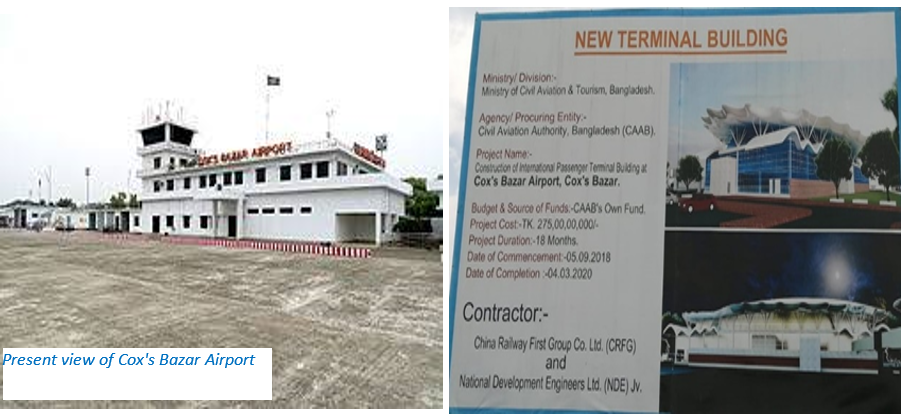
General Information
|
ICAO ID |
VGCB |
Time |
UTC+6 |
|---|---|---|---|
|
Latitude |
21.452194 (21° 27' 07.90" N) |
Longitude |
91.963889 (091° 57' 50.00" E) |
|
Elevation |
12 feet (4 meters) |
Magnetic Variation |
000° W (05/06) |
|
Operating Agency |
CAAB (Landing Fees and Diplomatic Clearance May be Required) |
||
|
Ground handling |
No equipment is available now. Only few hand trolleys and Ladder are available which are again arranged by the individual operators. |
||
|
Immigration |
- |
||
|
Fuelling |
Standard Asiatic Oil Ltd has been entrusted with the responsivity of proving Fuel to all the visiting aircrafts. At present they have 3 Fuel tanks with capacity of total 1,00,000 Ltr. They are located at the Airport vicinity and have 2 Refuellers to provide fuel to the aircrafts. They have 15 personnel at Cox’s Bazar (Contact Mr Nazmul, Manager-01715313454). |
||
|
Storage Capacity |
Nil, but the concrete parking area can be used for emergency purpose by raising temporary sheds over an area of approx. 45,000 sq ft. |
||
|
Operation Hours |
08:00 AM to 17:00 PM |
||
|
Man power |
Total 150 (CAAB-70+Attached-30+Project-50) |
||
|
Security arrangement |
Construction works are going on, so no fool-proof boundary wall is there. Own security personnel and Ansar is looking after the security of Airport. |
||
Cox's Bazar Airport started as a domestic airport in 1956. Due to the damage of the airport during liberation war in 1971, Cox's Bazar Airport was re-opened as a domestic airport at the end of 1971. This airport is situated on 941 acres of land. Cox's Bazar Airport is managed by the Civil Aviation Authority of Bangladesh. The airport is located 1.5 kilometres from Cox's Bazar City and 396km from Dhaka. This Airport operates only Cox’s Bazar- Dhaka passenger flights, but recently there is a flight between Cox’s Bazar and Chattogram twice a week. Ffour airlines are operating their passenger flights from and to Cox's Bazar Airport.
- Biman Bangladesh Airlines Ltd
- Novo Air Ltd
- Us Bangla Airlines Ltd
- Regent Airways Ltd
And following five cargo flights are operating their flights from Cox's Bazar Airport to Jashore for carrying fish fries.
- Sky Capital Airlines Ltd (3 FSO B737's)
- Bismillah Airlines Ltd (operating 2 aircraft; one AN28 and one HS-740)
- True Aviation Ltd (one AN26)
- Easy air Ltd (one SAAB 340).
Following facilities are available at the airport:
- Car parking
- Drinking water
- VIP/CIP Lounges
- Ramp and wheel chair facilities.
- Free Wi-Fi service
|
Md Abdullah Faruk Airport Manager, Cox's Bazar, Bangladesh. |
Cell: 01708167294, Telephone: +880341-52353, +880341-64479, Email: apmcox@caab.gov.bd TWR: +880341-62010 |
|
Runways |
||||||
|---|---|---|---|---|---|---|
|
ID |
Dimensions |
Surface |
PCN |
ILS |
||
|
9000 x 125 feet (2743 x 38 meters) |
Bituminous Concrete |
63/R/C/W/T |
NO |
|||
|
Description |
Runway 17 |
Runway 35 |
||||
|
Surface |
Bituminous concrete |
Bituminous concrete |
||||
|
True Heading |
1.690 |
3.490 |
||||
|
Latitude |
21.461336 (21° 27' 40.81" N) |
21.443056 (21° 26' 35.00" N) |
||||
|
Longitude |
91.962044 (091° 57' 43.36" E) |
91.965731 (091° 57' 56.63" E) |
||||
|
Elevation |
12.0 feet (4 meters) |
12.0 feet (4 meters) |
||||
|
Landing Distance |
8860 feet (2700 meters) |
8860 feet (2700 meters) |
||||
|
Takeoff Distance |
9500 feet (2895 meters) |
9500 feet (2895 meters) |
||||
|
Overrun Length |
460 feet (140 meters) |
490 feet (149 meters) |
||||
Future Development
Considering the importance and traffic at the present scenario the government has decided to expand and upgrade the Cox’s Bazar Airport to an international airport, its 2nd largest. Development works are going on and the new terminal building is expected to be completed by 2020. To promote Cox's Bazar Airport as International Airport, a project called Cox's Bazar Airport Development Project is in progress. Following works are being carried out under the project:
- Increase the runway length from 9,000 feet to 10,000 feet.
- Establishment of Airfield Ground Lighting System
- Purchase of firefighting vehicle
- ILS, DVOR, DME, FIDS, PA system etc.
- Construction of new terminal building on-going
Cox’s Bazar international airport is a huge proposed project by the government handled by the civil aviation authority of Bangladesh to provide the international standard facilities to the incoming passengers. Due to the geographical location and tourism characteristic of the area there is a continued air traffic growth that encourages Cox’s Bazar International Airport to be design more appropriately and equipped with better facilities. Beside the above ongoing development works, a master plan has been taken in hand to make this airport a modern international airport by 2030. As per this master plan total land over the area west of the existing runway till seashore is being acquisitioned. Necessary earth filling works is in progress to expand the runway up to 10,000 feet. The settlers of that area will be rehabilitated in a suitable area by the government.
For additional information, please see the following documents:
Bangladesh Common Information Airport Charges
Bangladesh Airports additional info
Bangladesh Costs 2013 Airfield Charges
Note: The information provided in the attached documents, which has been taken from the old DLCA, does not match the structure of the new LCA and is therefore provided separately.
For contact details, please see the following link:
2.2.9 Bangladesh Thakuragaon Airport
|
Airport Details |
|||
|---|---|---|---|
|
Country |
Bangladesh |
Latitude |
26° 2’ 0” N |
|
Province / District |
N/A |
Longitude |
88° 28’ 0” E |
|
Airport Name |
Thakuragaon Airport |
Elevation (ft) |
N/A |
|
IATA & ICAO codes |
TKR / VGSG |
Surface |
N/A |
|
Town or City (closest) |
Thakurgaon |
Runway Condition |
N/A |
|
NGO / UN (on ground) |
N/A |
Passenger / Cargo Security Screening (Yes / No) |
N/A |
|
Runway Dimension |
N/A |
Ground Handling (Yes / No) |
N/A |
|
Refueling Capacity |
N/A |
Runway Lighting (Yes / No) |
N/A |
|
Runway Heading |
N/A |
Fire Fighting Equipment (Yes / No) |
N/A |
|
Air Traffic Control (Yes / No) |
N/A |
Windsock (Yes / No) |
N/A |
|
Weather Information (Yes / No) |
N/A |
Aircraft Parking space (Yes / No) |
N/A |
|
Navigation Aids (Yes / No) |
N/A |
Perimeter fencing (Yes / No) |
N/A |
For additional information, please see the following documents:
Bangladesh Common Information Airport Charges
Bangladesh Airports additional info
Bangladesh Costs 2013 Airfield Charges
Note: The information provided in the attached documents, which has been taken from the old DLCA, does not match the structure of the new LCA and is therefore provided separately.
For contact details, please see the following link:
2.2.10 Bangladesh Ishurdi Airport
|
Airport Details |
|||
|---|---|---|---|
|
Country |
Bangladesh |
Latitude |
24.158347 / N 24° 09' 30.05" |
|
Province / District |
N/A |
Longitude |
24.158347 / N 24° 09' 30.05" |
|
Airport Name |
Ishurdi Airport |
Elevation (ft) |
N/A |
|
IATA & ICAO codes |
IRD / VGIS |
Surface |
Asphalt |
|
Town or City (closest) |
Ishurdi |
Runway Condition |
N/A |
|
NGO / UN (on ground) |
N/A |
Passenger / Cargo Security Screening (Yes / No) |
N/A |
|
Runway Dimension |
1432.6m x 24.4 |
Ground Handling (Yes / No) |
N/A |
|
Refueling Capacity |
N/A |
Runway Lighting (Yes / No) |
N/A |
|
Runway Heading |
N/A |
Fire Fighting Equipment (Yes / No) |
N/A |
|
Air Traffic Control (Yes / No) |
N/A |
Windsock (Yes / No) |
N/A |
|
Weather Information (Yes / No) |
N/A |
Aircraft Parking space (Yes / No) |
N/A |
|
Navigation Aids (Yes / No) |
N/A |
Perimeter fencing (Yes / No) |
N/A |
For additional information, please see the following documents:
Bangladesh Common Information Airport Charges
Bangladesh Airports additional info
Bangladesh Costs 2013 Airfield Charges
Note: The information provided in the attached documents, which has been taken from the old DLCA, does not match the structure of the new LCA and is therefore provided separately.
For contact details, please see the following link:
2.2.11 Bangladesh Shamshernagar Airport
|
Airport Details |
|||
|---|---|---|---|
|
Country |
Bangladesh |
Latitude |
24.39861 |
|
Province / District |
Shamshernagar |
Longitude |
91.92111 |
|
Airport Name |
Shamshernagar Airport |
Elevation (ft) |
N/A |
|
IATA & ICAO codes |
RJH / VGSH |
Surface |
Asphalt |
|
Town or City (closest) |
N/A |
Runway Condition |
N/A |
|
NGO / UN (on ground) |
N/A |
Passenger / Cargo Security Screening (Yes / No) |
N/A |
|
Runway Dimension |
1,650 m |
Ground Handling (Yes / No) |
N/A |
|
Refueling Capacity |
N/A |
Runway Lighting (Yes / No) |
N/A |
|
Runway Heading |
N/A |
Fire Fighting Equipment (Yes / No) |
N/A |
|
Air Traffic Control (Yes / No) |
N/A |
Windsock (Yes / No) |
N/A |
|
Weather Information (Yes / No) |
N/A |
Aircraft Parking space (Yes / No) |
N/A |
|
Navigation Aids (Yes / No) |
N/A |
Perimeter fencing (Yes / No) |
N/A |
For additional information, please see the following documents:
Bangladesh Common Information Airport Charges
Bangladesh Airports additional info
Bangladesh Costs 2013 Airfield Charges
Note: The information provided in the attached documents, which has been taken from the old DLCA, does not match the structure of the new LCA and is therefore provided separately.
For contact details, please see the following link:
2.2.12 Bangladesh Tejgaon Airport
Tejgaon Airport in Dhaka served as the country's sole international airport prior to the construction of Shahjalal International Airport. Following the transfer of civilian flights to the newly built Shahjalal International Airport in 1981, Tejgaon was taken under the control of the Bangladesh Air Force.
It is probable that Tejgaon Airport will be an important operational base for air relief operations (as it was during Cyclone Sidr emergency operations in 2007) for the Armed Forces Division and the Air Force and the other Bangladesh Defense Forces. The compound includes all necessary facilities (storage capacities, operational rooms, etc.) as well as significant areas for open storage and/or setting up Mobile Storage Units (MSU's).
General Information
|
ICAO ID |
VGTJ |
Time |
UTC+6 |
|---|---|---|---|
|
Latitude |
23.778783 (23° 46' 43.62" N) |
Longitude |
90.382689 (090° 22' 57.68" E) |
|
Elevation |
24 feet (7 meters) |
Type |
Military |
|
Magnetic Variation |
000° W (05/06) |
Operating Agency |
Military |
|
Runways |
|||||
|---|---|---|---|---|---|
|
ID |
Dimensions |
Surface |
PCN |
ILS |
|
|
9315 x 98 feet (2839 x 30 meters) |
Asphalt |
012FCYT |
NO |
||
|
Description |
Runway 17 |
Runway 35 |
|||
|
Surface |
Asphalt |
Asphalt |
|||
|
True Heading |
1.640 |
3.440 |
|||
|
Latitude |
23.791131 (23° 47' 28.07" N) |
23.766436 (23° 45' 59.17" N) |
|||
|
Longitude |
90.378953 (090° 22' 44.23" E) |
90.386422 (090° 23' 11.12" E) |
|||
|
Landing Distance |
7530 feet (2295 meters) |
8310 feet (2533 meters) |
|||
|
Takeoff Distance |
9315 feet (2839 meters) |
9315 feet (2839 meters) |
|||
|
Displaced Threshold Length |
1785 feet (544 meters) |
1005 feet (306 meters) |
|||
Bangladesh Common Information Airport Charges
Bangladesh Airports additional info
Bangladesh Costs 2013 Airfield Charges
Note: The information provided in the attached documents, which has been taken from the old DLCA, does not match the structure of the new LCA and is therefore provided separately.
For contact details, please see the following link:
2.2.13 Bangladesh Comilla Airport
|
Airport Details |
|||
|---|---|---|---|
|
Country |
Bangladesh |
Latitude |
23.43681 |
|
Province / District |
N/A |
Longitude |
91.18986 |
|
Airport Name |
Comilla Airport |
Elevation (ft) |
N/A |
|
IATA & ICAO codes |
CLA / - |
Surface |
N/A |
|
Town or City (closest) |
Comilla |
Runway Condition |
N/A |
|
NGO / UN (on ground) |
N/A |
Passenger / Cargo Security Screening (Yes / No) |
N/A |
|
Runway Dimension |
1.650m x n/a |
Ground Handling (Yes / No) |
N/A |
|
Refueling Capacity |
N/A |
Runway Lighting (Yes / No) |
N/A |
|
Runway Heading |
N/A |
Fire Fighting Equipment (Yes / No) |
N/A |
|
Air Traffic Control (Yes / No) |
N/A |
Windsock (Yes / No) |
N/A |
|
Weather Information (Yes / No) |
N/A |
Aircraft Parking space (Yes / No) |
N/A |
|
Navigation Aids (Yes / No) |
N/A |
Perimeter fencing (Yes / No) |
N/A |
For additional information, please see the following documents:
Bangladesh Common Information Airport Charges
Bangladesh Airports additional info
Bangladesh Costs 2013 Airfield Charges
Note: The information provided in the attached documents, which has been taken from the old DLCA, does not match the structure of the new LCA and is therefore provided separately.
For contact details, please see the following link:
2.3 Bangladesh Road Network

Overview
The main road network of the country is under the Roads and Highways Department (RHD). Maintenance of the roads including bridges is carried out by RHD. There is approximately 21,483 km of roads under this department. The road network capable to carry vehicles has increased significantly and is increasing every year. Bangladesh government realises the importance of road maintenance and the RHD has given more emphasis on this subject. Only a few years back there was no proper planning and system for road maintenance and international agencies assisted the Government of Bangladesh to address and solve the problem.
The Ministry of Road Transport and Bridges is the body for formulation and administration of the rules, regulations and laws relating to road transport, national highways and bridges. Bangladesh has 4 ministries responsible for transportation within the country. They are:
- Ministry of Road Transport and Bridges- responsible for road safety.
- Ministry of Civil Aviation and Tourism- responsible for civil aviation.
- Ministry of Shipping- responsible for maritime transport.
- Ministry of Railways- responsible for rail transport.
The Ministry of Road Transport and Bridges has 2 Divisions : the Road Transport and Highways Division and the Bridge Division. RHD has again 4 components
- Roads and Highways Department
- Bangladesh Road Transport Authority
- Bangladesh Road Transport Corporation
- Dhaka Transport Coordination Authority
Roads and Highways Department (RHD)
The Roads and Highways Department (RHD) within the Ministry of Road Transport and Bridges, is responsible for the management of approximately 21,483 km comprising 3 categories of road classes (National, Regional and Zilla road).
List of Officers- RHD
|
Sl |
Office Name & Designation |
Cell No |
|
|---|---|---|---|
|
1 |
Chief Engineer, RHD |
01730782500 |
|
|
2 |
Addl Chief Engineer (Dhaka Planning & Maintenance Wing) |
01730782520 |
|
|
3 |
Addl Chief Engineer, (Dhaka Zone) |
01730782592 |
|
|
4 |
Addl Chief Engineer (Chattogram Zone) |
01730782677 |
|
|
5 |
Addl Chief Engineer (Rajshahi Zone) |
01730782703 |
|
|
6 |
Addl Chief Engineer (Cumilla Zone) |
01730782639 |
|
|
7 |
Addl Chief Engineer (Rangpur Zone) |
01730782725 |
|
|
8 |
Addl Chief Engineer (Khulna Zone) |
01730782754 |
|
|
9 |
Addl Chief Engineer (Barisal Zone) |
01730782782 |
|
|
10 |
Addl Chief Engineer (Sylhet Zone) |
01730782660 |
Road Network at a Glance
Road Data
|
Road length by classification |
|
|---|---|
|
National Highway |
3,544.06 Km |
|
Regional Highway |
4,280.02 Km |
|
Zilla Road |
13,659.13 Km |
|
Total Road Length |
21,483.21 Km |
|
Road Length by Surface Type according to latest survey |
|
|
Bituminous |
16,815.61 Km |
|
Earth |
698.47 Km |
|
HBB |
660.81 Km |
|
Cement Concrete (CC) |
2.44 Km |
|
Cement Blocks |
0.37 Km |
|
Total Paved Road Length |
17,516.89 Km |
|
Total Unpaved Road Length |
660.81 Km |
|
Total Surveyed Road Length |
18,177.70 Km |
|
Length of Road Not Surveyed |
3,305.51 Km |
|
Number of Culverts |
|
|
Slab Culvert |
3991 |
|
Box Culvert |
9441 |
|
Arch Masonry |
318 |
|
Pipe Culvert |
1 |
|
Total Number of Culverts |
13751 |
|
Number of Bridges |
|
|
Truss with Timber Deck |
8 |
|
Truss with RCC Slab |
68 |
|
RCC Bridge |
325 |
|
RCC Girder Bridge |
4089 |
|
Steel Beam & RCC Slab |
335 |
|
PC Box |
9 |
|
Baily with Steel Deck |
1438 |
|
Baily with Timber Deck |
36 |
|
Truss with Steel Deck |
538 |
|
PC Girder Bridge |
895 |
|
Total Number of Bridges |
7741 |
|
Total Number of Structures |
21492 |
Categories of Roads
National Highways connect the national capital with different divisional and old district headquarters port cities and international highways. These roads have been categorised as National Highways considering the national importance and geographical positions. Each National Highway has been provided with a name and a number, such as Dhaka-Chattogram Highway has been numbered N-1 whereas N stands for National. This number can only be changed by RHD headquarters.
|
Highway No. |
Detailed Route |
Length |
|---|---|---|
|
N1 |
Dhaka (N8) - Katchpur (N2) - Madanpur (N105) - Mainamati (N102) - Cumilla (R140) - Feni (N104) - Chattogram (N106) - Manashertek (N107) - SaBDTania (N108) - Ramu (N109) - Cox's Bazar (N110) - Teknaf |
455 km |
|
N2 |
Katchpur (N1) - Bhulta (N105) - Sarail (N102) - Jagadishpur (N204) - Shaistaganj (N204) - Mirpur(N207) - Sherpur (N207) - Sylhet (N205, *N208) - Jaintiapur - Jaflong |
286 km |
|
N3 |
Dhaka - Progoti Sarani (N301) - Tongi (N302) - Joydebpur (N105, N4) - Mymensingh |
112 km |
|
N4 |
Joydebpur (N3, R310) - Kadda (N105) - Tangail (N404) - Elenga (N405) - Madhupur (N401) - Jamalpur |
146 km |
|
N5 |
Dhaka - Mirpur Bridge (N501) - Nabinagar (R505) - Manikganj (R504) -Muljan - Uthali (N503) - (ferry) - Natakhola - Baderhat (N505, N513) - Kashinathpur (N6, N504) - Shahjanpur (N515) - Banani (N514) - Bogura western bypass: Jahangirabad (N502) - Tinmatha (N510) - Matidali (N514, N515) - Mordern More (N506) - Rangpur bypass (N517) - Saidpur bypass (N518) - Beldanga (N508) - Thakurgaon - Panchagarh - Tentulia - IND (Banglabandha) |
507 km |
|
N6 |
Kashinathpur (N5, N504) - Pabna bypass (N604) - Gaspara (N604) - Dasuria (N704, N705) - Banpara (N507) - Harispur (N602) - Chawk Bidaynath (N602) - Belpukur (N603) - Rajshahi (R680) |
150 km |
|
N7 |
Daulatdia Ferryghat - Goalchamot (N803) - Magura (N704) - Arappur (N704) - Jhenaidah - Hamdah (N703) - Palbari (N707, N708) - Chanchra (N706) - Murail (N707) - Phultala (N709) - Khulna - (ferry) - Kudir Battala (N709) – Digraj |
252 km |
|
N8 |
Dhaka - Mawa Ferryghat (R812) - (ferry) - Bhanga (N804, N805) - Barisal (N809) - Patuakhali |
191 km |
|
N102 |
Sarail (N2) - Ghaturia (N103) - Brahmanbaria - Kuatali (N103) - Mainamati (N1) |
82 km |
|
N104 |
Feni (N1) - Chowmohani (R140) - Noakhali - Somapur R140 connects to N809 at Lakshmipur |
49 km |
|
N105 |
Kadda (N4) - Joydebpur (N3) - DeBoguram (N301) - Bhulta (N2) - Madanpur (N1) Dhaka eastern bypass, partly under construction |
49 km |
|
N106 |
Chattogram (N1) - Hathazari - Rangamati |
65 km |
|
N107 |
Manashertek (N1) - Boalkhali |
12 km |
|
N108 |
22 km |
|
|
N204 |
Jagadishpur (N2) - Chunarughat - Shaistaganj (N2) |
34 km |
|
N207 |
Mirpur (N2) - Srimangal - Moulvibazar (N208) - Sherpur (N2) |
68 km |
|
N208 |
Moulvibazar (N207) - Sylhet bypass (N2, N209) |
59 km |
|
N301 |
Progoti Smarini (N3) - DeBoguram (N105) under construction |
13 km |
|
N302 |
Tongi (N3) - Dhour (N501) - Yearpur (N511) - Baipal (R505) R505 connects to N5 at Nabinagar |
18 km |
|
N309 |
Khagdahar (N401) - Mymensingh bypass (N3) |
13 km |
|
N401 |
Madhupur (N4) - Khagdahar (N309) - Mymensingh (N3) |
47 km |
|
N405 |
Elenga (N4) - Hatikamrul (N5, N507) |
18 km |
|
N501 |
Mirpur Bridge (N5) - Berulia (N511) - Dhour (N302) |
14 km |
|
N502 |
Natore (N602) - Bogura (N5) |
63 km |
|
N506 |
Mordern More (N5) - Lalbag more (N517) - Barabari (N509) - Kurigram |
50 km |
|
N507 |
Hatikamrul (N5, N405) - Banpara (N6) |
51 km |
|
N508 |
Beldanga (N5) - Dinajpur (R585) |
16 km |
|
N509 |
Baranari (N506) - Lalmonirhat - Patgram - IND (Burimari) |
105 km |
|
N511 |
Berulia (N501) - Yearpur (N302) |
13 km |
|
N513 |
Baderhat (N5, N505) – Khayerchar |
11 km |
|
N515 |
Shahjanpur (N5) - Matidali Bogura eastern bypass, under construction |
16 km |
|
N603 |
Belpukur (N6) - Paba - Kashiadanga (R680) |
21 km |
|
N702 |
Magura (N7) - Jashore (N708, N706, N707) |
44 km |
|
N704 |
Dasuria (N6, N705) - Ruppur (N705) - Kushtia - Arappur (N7) - Jhenaidah (N703) |
81 km |
|
N706 |
Jashore (N702, N707) - Chanchra (N7) - Benapole (N711) - IND (NH35) |
38 km |
|
N709 |
Khulna bypass: Phultala (N7) - Kudir Battala (N7) |
27 km |
|
N804 |
Alipur (N803) - Bhanga (N8, N805) |
32 km |
|
N805 |
Bhanga (N8, N804) - Bhatiapara (N806) - Gopalganj (R850) - Mollarhat (R856) Gopalganj section under construction |
80 km |
|
N809 |
Barisal (N8) - (ferry) - Chatarmatha - (ferry) - Lakshmipur (R140) R140 connects to N104 at Chowmohani |
50 km |
Regional Highways connect different regions and new district headquarters not connected by National Highways and Zilla Roads. Regional Highways are named after National Highways of national importance. Names and numbers of these highways are decided such as Cumilla-Lalmai, R-140, whereas R stands for Regional meaning the Region. This number can only be changed by RHD headquarters.
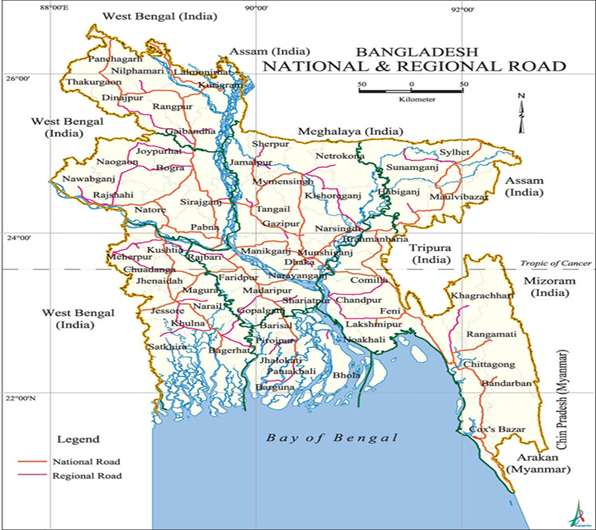
Zilla Roads are defined as Roads connecting Upazila head quarters and other important rural centres with the existing Road network. Name and numbers of these roads are decided such as Akhaura-Agartala, Z-1203 whereas Z stands for Zilla.
Important Highway Conditions
|
Dhaka-Chattogram- Cox’s Bazar Highway General Information |
|
|---|---|
|
Total distance |
Approx 406 Km |
|
Total travel time |
9-10 hours |
|
Road classification |
National Highway |
|
Security (Good, marginal, bad) |
Security is good, while road safety is bad as in the entire country |
|
Main towns/hubs |
Dhaka, Narayongonj, Munshigonj, Cumilla, Feni, Chattogram and Cox’s Bazar |
|
Seasonal variations |
Floods may occur temporarilly during the Monsoon season |
|
Bridges and Obstacles |
4 (Kachpur, Meghna, Daudkandi and Karnaphuli bridge) |
|
Traffic conditions |
Congested in few choke points
|
|
Dhaka-Sylhet-Tamabil Highway General Information |
|
|
Total distance |
Approx 287 Km |
|
Total travel time |
5 to 6 hours |
|
Road classification |
National Highway |
|
Security (Good, marginal, bad) |
Security is good, while road safety is bad as in the entire country |
|
Main towns/hubs |
Dhaka, Tarabo, Borpa, Bhulta, Pachdona, Shahepratap, Itakhola, Bhairab, Sarail, Jagadishpur, Shaistaganj, Mirpur, Aushkandi, Syedpur, Sherpur and Tamabil |
|
Seasonal variations |
Floods may occur temporarilly during the Monsoon season |
|
Bridges and Obstacles |
2 ( Kanchan, Bhairab, Sherpur, Keane and shari bridge) |
|
Trafic Condition |
Congested in few choke points |
|
Dhaka-Banglabandha Highway General Information |
|
|
Total distance |
Approx 529 Km |
|
Total travel time |
11-12 hours |
|
Road classification |
National Highway |
|
Security (Good, marginal, bad) |
Security is good, while road safety is bad as in the entire country |
|
Main towns/hubs |
Dhaka, Manikgonj, Pabna, Sirajgonj, Bogura, Gaibandha, Rangpur, Nilphamari,Dinajpur, Thakurgaon and Panchgarh. But shortcut is following N4 upto Jamuna bridge (via Gajipur and Tangail) |
|
Seasonal variations |
Floods may occur temporarily during the Monsoon season |
|
Bridges and Obstacles |
Jamuna Bangabondhu bridge) |
|
Trafic Condition |
Congested in few choke points
|
|
Dhaka-Jashore- Benapole Highway General Information |
|
|
Total distance |
Approx 234 Km |
|
Total travel time |
7-8 hours |
|
Road classification |
National Highway |
|
Security (Good, marginal, bad) |
Security is good, while road safety is bad as in the entire country |
|
Main towns/hubs |
Dhaka, Manikgonj, Faridpur, Magura, Jashore, Benapole (Follow N5, N7, N702 and N706) |
|
Seasonal variations |
Floods may occur temporarilly during the Monsoon season |
|
Bridges and Obstacles |
(Paturia Ferry and Modhukhali Bridge) |
|
Trafic Condition |
Congested in few choke points
|
|
Dhaka-Gopalgonj-Mongla Highway General Information |
|
|
Total distance |
Approx 240 Km |
|
Total travel time |
7-8 hours (excluding Ferry time) |
|
Road classification |
National Highway |
|
Security (Good, marginal, bad) |
Security is good, while road safety is bad as in the entire country |
|
Main towns/hubs |
Dhaka, Munshigonj, Mawa, Bhanga (Madaripur) (following N8), Gopalgonj (following N805), Bagerhat, then follow N7 to reach Mongla. |
|
Seasonal variations |
Floods may occur temporarilly during the Monsoon season |
|
Bridges and Obstacles |
Babubazar/Postogola, Dhaleshwari bridge, Padma bridge/Ferry, Arial Khan and Mollahat bridge) |
|
Trafic Condition |
Congested in few choke points |
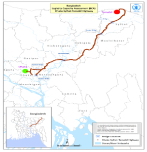
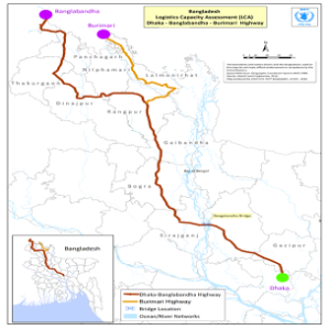
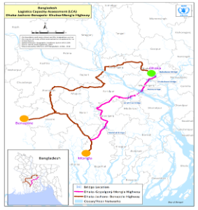
Development Projects
The Bangladesh Road Master Plan 2007 estimated the medium growth forecast of both freight and passenger transport which will be 6% over the master plan period of 2005-25. As such, issues related to road network have been identified by RHD, which are follows:
- National Highways are needed to be upgraded into 4/6 lanes with medians to commensurate with higher traffic growth and to improve road safety
- Construction of new bridges to ensure uninterrupted traffic flow including replacement and major repair of existing old narrow bridges for ensuring safety
- Road safety to be properly addressed in road design and enforced in traffic management
- Developing comfortable road network to enhance the tourism industry
- Maintenance needs a higher priority, more resources, improved management reform and better quality standard
- Institutional reform, and
- Digitalization of RHD activities
In addition, LGED under the purview of rural road master plan has been developing the farm to market roads. It has prioritized Upazila, Union and Village roads and a target was set for development of additional 22000 Km Upazila and Union Roads in future. The low lying topography requiring a substantial raised earth embankment of
all kinds of roads, frequent flooding during monsoon due to global climate change phenomena and washing out the road embankment are emerging of challenges of the sector.
Important Ongoing Projects
Construction of Tunnel under the River Karnaphuli, Ctg
The implementation work of 3.40 kilometer long tunnel under the river Karnaphuli at a cost of BDT.8,446.46 crore is progressing and 20 percent of physical work has already been completed. This tunnel will connect west part of Chattogram city to East part, reduce traffic jam and ease direct road communication among Dhaka- Chattogram-Cox’s Bazar. Besides, it will contribute to GDP growth about 0.16 percent. The project has been approved in the ECNEC meeting in 24 November 2015. Land acquisition and preparation of detailed design work is in progress.
Construction of BRT Lane (Elevated Section)
Steps have been taken to construct of 20 kilometer long Bus Rapid Transit (BRT) lane at the cost of BDT.2,039.85 crore from Gazipur to Hazrat Shah Jalal(R) international Airport. Bangladesh Bridge Authority (BBA) is responsible for implementation of 4.5-kilometer elevated section. The implementation work is progressing and expected to be completed in 2020
Construction of Dhaka-Ashulia Elevated Expressway
To construct about 24-kilometer-long Dhaka-Ashulia Elevated Expressway from Hazrat Shah Jalal (R) international airport to EPZ through Ashulia, the project has been approved by the ECNEC with an estimated cost of BDT. 16,901.32 crore. To construct the expressway on G-to-G basis, commercial agreement has been signed with a Chinese Government nominated company. It is expected to complete the project by 2022. It will connect Asian Highway Network and almost all National Highway. Moreover, it will reduce traffic congestion in Abdullahpur-Ashulia-Baipail-Chandra corridor.
Construction of Dhaka East-West Elevated Expressway
To construct about 39.24 kilometer long Elevated Expressway from Baliapur of Dhaka-Aricha highway to Langolbond of Dhaka-Chattogram road through Nimtoli-Keranigonj-Fatulla-Bandor, PDPP has been approved with an estimated cost of BDT.16,388.50 crore. Malaysian Government has given proposal to construct it through G-to-G basis. This expressway will connect National Highways and Asian Highway. It will reduce traffic congestion in and around Dhaka city and traffic from Chattogram, Sylhet and other eastern part and from south western region through Padma Bridge to the north-western districts will be convenient.
Conduct Feasibility Study to Construct Subway (Underground Metro) in Dhaka city
Initiative has been taken to construct subway in order to reduce traffic jam in Dhaka city. In this process 4 preliminary alignments have been selected. But present plan is to construct route-1 (Tongi- Airport- Kakoli- Mohakhali- Moghbazar- Palton- Shapla Chottor-Sayedabad- Narayangonj Signboard) and Route-2 (Aminbazar-Gabtoli-Asad gate-New market-TSC-Ittefaq-Sayedabad). To conduct Feasibility Study, the consultant has been appointed with the cost of BDT.219.44 crore and study will start very soon.
Feasibility Study of Tunnel Under the River Jamuna
Initiative has been taken to conduct feasibility study to construct tunnel under the river Jamuna which connects Gaibandha and Jamalpur district. The study will start in time after approval of proposed project by the concern authority.
Construction of Other Large Bridges
In order to maintain uninterrupted road network, initiatives have been taken to build new bridges at different location. As a part of this, feasibility study for construction of bridges at ‘Rahmatpur-Babugonj-Muladi-Hijla’ roads over Arialkha river, at ‘Lebukhali-dumki-boga-Doshamina-golacipa -Amragachi’ roads over Golacipa river, at ‘Kocua-betagi-Potuakhali-Lohalia-Kalia’ roads over Payra river has been completed. PDPP has been approved for these three proposed bridge costing of BDT.1,944.24 crore. It is expected that construction of these bridges will start very soon.
Moreover, feasibility study is going on for 5 other bridges; over Payra river in Patuakhali-Amtoli-Borguna roads, over Karkhana river in Bakergonj-Baufol road, over Meghna river in Bhulta-Araihazar-Nabinagar roads, over Bishkhali river in Borguna-Pathorghata road and over Tetulia and Kalabodor river which connect Barishal with Bhola. Construction work of these bridges will start in time.
Road Distance Matrix
Distance Matrix for all the districts of Bangladesh is shown as a chart below:
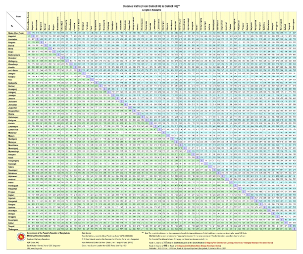
Bangladesh Road Transport Authority (BRTA)
Bangladesh Road Transport Authority (BRTA) was Established under section 2A of Motor Vehicle Ordinance 1983, (Amendment-1987) Vide SRO No-303/Law/87/MVRT/1E-7/84(part), Dated 20/12/87 and has been functioning since January 1988. BRTA is the regulatory body to control, manage and ensure discipline in the road transport sector and road safety related areas in Bangladesh. It is an authority under the Ministry of Roads and Bridges for carrying out the purposes mentioned in the Motor Vehicle Ordinance, 1983. The Chairman is the chief executive of the authority. He exercises such power and performs such function as prescribed by rules and assigned by the government from time to time. For further details please see http://www.brta.gov.bd
Activities of BRTA
- Controlling and regulating road transport by executing motor vehicle acts, issuing route permits and fixing rates and fares of buses and trucks
- Conducting regular activities like: Issuing driving license, fitness certificates, registration certificates and Driving Instructor's license
- Registering schools for motoring
- Organizing and conducting workshop Seminars for delivering information regarding safe driving and traffic regulations
- Making research and development for developing ideas and methodologies for safe road transport and traffic system.
|
BRTA Office Address |
Tel / Email |
|---|---|
|
Bangladesh Road Transport Authority (BRTA) Head Office: “BRTA Bhaban” |
Phone: +88-02-55040711 |
Bangladesh Road Transport Corporation (BRTC)
The Bangladesh Road Transport Corporation (BRTC) is the state-owned transport corporation of Bangladesh. It was established under the Government Ordinance No.7 of 1961 dated 4 February 1961. Following the independence of Bangladesh in 1971, it assumed its current name. BRTC is a semi-autonomous corporation under the Ministry of Roads and Bridges. BRTC provides both passenger and cargo transport services.
BRTC operates 3 international bus services (Dhaka to Kolkata, Agartala, and Siliguri in India). Inside Bangladesh, it operates inter-district bus services through its bus depots in Chattogram, Bogura, Cumilla, Pabna, Rangpur, Barisal and Sylhet. It also operates intra-city bus services in many major cities of the country. For transportation of cargo, BRTC operates a fleet of 170 trucks. About twenty percent of the government food transport uses BRTC's trucks. The two main truck depots are located at Dhaka and Chattogram.
BRTC's main driver training institute is located in Joydevpur, Gazipur District, about forty kilometres north of Dhaka. It also has several other training institutes located in Chattogram, Bogura, Khulna, and Jhenaidah. For more details please see: http://www.brtc.gov.bd/
Activities of BRTC
- To operate road transport services for both passengers and cargo.
- To provide safe, reliable and efficient transport service at an affordable fare.
- To facilitate private sector in transport service and introduction of new routes.
- To play strategic interventional role at the time of emergency.
- To provide training facilities for Drivers, Mechanics and in transport management in order to develop skilled manpower in the road transport sector for both home and abroad.
- To utilize BRTC's land and properties for additional revenue earnings for subsidizing the unprofitable bus routes and services for disabled, women's, students, government employees, poor and destitute etc.
- To contracting out and sub-contracting the buses to the able private owners so as to promote
competition for quality services and co-existence of the public-private relationship in the road transport sector for greater private sector participation in the operation of BRTC buses.
- To research vehicle and engine types and safety considerations for bringing harmony in operation of the bus and truck services and to combat the air pollution's factor for better environment.
List of BRTC Officials are as follows:
| Name | Designation | Phone (Office) | |
|---|---|---|---|
|
Mr. Farid Ahmed Bhuiyan (Additional Secretary) |
Chairman |
02-9554350 Cell: 01817-092917 |
|
|
Md. Hamidur Rahman |
Director (Admin) |
02-9551944 Cell: 01712690335 |
|
|
Dr. Nasim Ahmed (Joint Secretary) |
Director (Finance) |
02-9585909 Cell: 01740-452324 |
|
|
Colonel Md. Mahbubur Rahman |
Director (Technical) |
02-9557952 Cell: 01743094449 |
|
|
Md. Kamrul Islam |
General Manager (Admin & Personal) |
02-9555807 Cell: 01700565856 |
|
|
Md. Amjad Hossain |
General Manager (Accounts) |
02-9551985 Cell: 01711038883 |
|
|
Major Alimur Rahman |
General Manager (Technical) |
02—9565774 Cell:01914495939 |
|
|
Nur-E-Alom |
Secretary, BRTC |
02-9587355 Cell: 01711-435213 |
BRTC Bus Depots
|
Sl |
Name of Depot |
Office |
Mobile |
|---|---|---|---|
|
1 |
Motijheel Bus Depot |
9333803 |
01714-293920 |
|
2 |
Joarshara Bus Depot |
58951778 |
01711-302124 |
|
3 |
Kallyanpur Bus Depot |
9002531 |
01818-485388 |
|
4 |
Double Decker Bus Depot |
9002395 |
01711-391514 |
|
5 |
Mohammadpur Bus Depot |
- |
01734-053991 |
|
6 |
Gabtoli (Utholi) Bus Depot |
- |
01711-578744 |
|
7 |
Gazipur Bus Depot |
9261443 |
01711-435213 |
|
8 |
Narayangonj Bus Depot |
7646915 |
01712-187790 |
|
9 |
Norsingdi Bus Depot |
- |
01716-473972 |
|
10 |
Cumilla Bus Depot |
081-61988 |
01716-684144 |
|
11 |
Sonapur Bus Depot |
- |
01758-880011 |
|
12 |
Chattogram Bus Depot |
031-683423 |
01919-465266 |
|
13 |
Sylhet Bus Depot |
- |
01717-763820 |
|
14 |
Bogura Bus Depot |
051-66145 |
01718-700478 |
|
15 |
Pabna Bus Depot |
0731-64768 |
01711-302124 |
|
16 |
Rangpur Bus Depot |
0521-64110 |
01817-782866 |
|
17 |
Khulna Bus Depot |
041-786143 |
01714-240653 |
|
18 |
Barisal Bus Depot |
0431-63793 |
01717-438644 |
|
19 |
Dinajpur Bus Depot |
- |
01712-382144 |
|
BRTC Truck Depot |
|||
|
1 |
Dhaka Truck Depot |
02-9112103 |
01716-039588 |
|
2 |
Chattogram Truck Depot |
031-684058 |
- |
Dhaka Transport Co-ordination Authority (DTCA)
Dhaka Transport Coordination Authority was established on 02 September 2012 to prepare strategic Transport Plan and provide regular supervision and co-ordination for all possible planning for transportation infrastructure development works within Dhaka city and adjacent districts. DTCA jurisdiction covers 7400 Sq km that includes districts of Dhaka, Narayangonj, Munshigonj, Mankgonj, Gazipur and Narsingdi district including Dhaka North City Corporation, Dhaka South City Corporation, Gazipur City Corporation and Narayanganj City Corporation. BTCA is responsible to provide a planned modernized transportation system for greater Dhaka area and Ensure safe, reliable, faster and affordable Public Transport by introducing integrated transport planning.
Objectives and Functions of DTCA
- To ensure interagency cooperation and coordination in transportation sector
- To ensure an integrated and planned transportation system formulation
- To introduce and expand Mass Rapid Transit system
- To improve traffic management
- To improve public transport level of service
- To develop and construct mass transit system as part of an integrated public transport network
- Design, planning and construction of Bus Rapid Transit (BRT) system
- Review and modification of the Government approved Strategic Transport Plan (STP) and to provide advice and guidance for other agencies
- Traffic impact assessment of government or private owned high rise building and any housing project and issue permit for traffic circulation plan
- Plan, coordinate and approve recommended transport projects of other agencies
- Route and network planning to develop an efficient public transport network
- Manage central fare collection and establish and manage clearing house
Road Security
Vehicles without fitness, unskilled drivers, violation of traffic rules, absence of proper road marks and poor maintenance condition of roads, etc. have contributed to an alarming number of road accidents. Road accidents have become a daily and deadly phenomenon in Bangladesh that has one of the worst crash rates in the world, at more than 60 per 10,000 registered motor vehicles. The official death toll for road traffic accidents is about 4,000 a year. Road safety activists blame shoddy roads, poorly maintained vehicles and reckless drivers for such fatal accidents causing thousands of deaths every year. Research studies show multifaceted causes of road accidents ranging from population explosion, unplanned urbanisation, and tremendous growth of motorised as well as non-motorised vehicles. Improper traffic management is also termed a major cause of road accidents. According to the Bangladesh Jatrikalyaan Samiti's database, 7,397 people were killed in 4,979 road accidents with 16,193 casualties only in 2017. Government intervention to this effect has stopped race of accidents but more pragmatic measures are urgently required.
Road Safety measures taken by the Government
A road redesign project is being implemented through identifying the accident black spots on the national highways. The intensity of road accidents has been reduced due to proper maintenance of road and straightening of road alignment. The ‘Improvement of Black Spots in National Highways’ for the treatment of 121 black spots at an estimated cost of BDT.168.05 crore has been completed during FY2016-17. On the other hand, a vast program for safety on road through overload control by means of installing weighbridge at each important traffic origination point, signing and signaling of roads is under implementation for a long time. In addition, a feasibility report was submitted by the Accident Research Institute (ARI) on accident-prone spots that were identified by the Highway Police to reduce the accidents to a minimum level. The approval process of the project ‘Establishment of necessary sign and road marking on National and Regional Highways and development of dangerous risky corridor in the identified risky areas’ is in progress in order to set up sign and marking at 128 new spots.
At present, a study project to design properly of at 752 intersection points at a cost of BDT.3.24 crore. An investment project will be taken up for the development of intersection points according to the project design.
Bridges of Bangladesh
All the bridges & tunnels having length of 1500 m or over are looked after by the Bangladesh Bridge Authority (BBA). BBA is an autonomous organization under the Bridges Division with a total manpower 211 staff. the Bridges Division under the Ministry of Road Transport & Bridges was established in March 2008, and has played an important role in the transport sector of the country. As per the Rules of Business, implementation & maintenance of bridges, toll road, flyover, expressway, causeway, ring road etc. have come under the purview of this Division. Head office of BBA is at “Setu Bhaban”, New Airport Road, Banani, Dhaka.
Contact list of important officers of BBA are:
| Name | Designation | Phone (Office) | Mobile | |
|---|---|---|---|---|
|
Khandker Anwarul Islam |
Executive Director |
+880255040333 |
01755589048 |
|
|
Md. Rezaul Haider |
Director (Administration) |
+880255040310 |
01700716307 |
|
|
Dr. Md.Golam Faruque |
Director (Planning & Development) |
+880255040312 |
01715126819 |
|
|
Quazi Muhammad Ferdous |
Director (Tech) |
+880255040313 |
01715102074 |
|
|
MD. Rupam Anwar |
Additional Director (Planning & Development) |
+880255040340 |
01700716310 |
|
|
Mahmood Ibne Kasem |
PS to Executive Director |
+880255040320 |
01700716311 |
Major Bridges in Bangladesh
In recent years, the construction of a number of bridges such as the Bangabandhu Jamuna Bridge, Meghna Bridge, Meghna-Gumti Bridge, Bangladesh-China Friendship Bridge, Shambhuganj Bridge and Mahananda Bridge as been completed. It has established a strategic link between the East and the West of Bangladesh has integrated the country, is generating multifaceted benefits to the people and promoting inter-regional trade. Apart from quick movement of goods and passenger traffic, it is facilitating transmission of electricity and natural gas and has integrated the telecommunication links.
Major Bridges of Bangladesh are:
|
Name of Bridges |
Name of Roads |
Length (M) |
|
|---|---|---|---|
|
Jamuna Bridge (Under Jamuna Bridge Authority) |
Dhaka – Bogura |
4800 |
|
|
Lalon shah (Paksey) Bridge |
Ishwardi - Kustia Road |
1786 |
|
|
Meghna - Gumti (Daud Kandi) Bridge |
Dhaka - Chattogram |
1408 |
|
|
Khan Jahan Ali (Rupsa) Bridge |
Khulna-Mongla/Bagerhat/Gopalgonj |
1360 |
|
|
Bangladesh UK Friendship (Bhairab) Bridge |
Dhaka – Sylhet |
1194 |
|
|
2nd Buriganga Bridge |
Dhaka-Gopalgonj |
1016 |
|
|
Meghna Bridge |
Dhaka - Chattogram |
930 |
|
|
Gabkhan Bridge |
Barisal - Patuakhali |
918 |
|
|
Hajrath Shah Amanath Bridge |
Chattogram - Cox's Bazar |
914 |
|
|
Ist Bangladesh China Friendship (Postagola) Bridge |
Dhaka-Gopalgonj |
848 |
|
|
Kaliganga Bridge |
Dhaka – Aricha |
647 |
|
|
Gorai Bridge |
Faridpur – Jashore |
630 |
|
|
Karotoa Bridge |
Boda – Debigonj |
572 |
|
|
Bagabari Bridge |
Pabna – Sirajgong |
570 |
|
|
Dhaleswari Bridge |
Dhaka – Mawa |
492 |
|
|
Shambugonj Bridge |
Mymensing - Haluaghat |
464 |
|
|
Mohananda Bridge |
Rajshahi - Nawabgonj |
448 |
|
|
Brahmaputra Bridge |
Dhaka – Sylhet |
443 |
|
|
Bridges under Construction by RHD |
|||
|
Padma Multipurpose Bridge |
Dapdapia Bridge |
||
|
2nd Sitalakhya Bridge |
3rd Karnafuly Bridge |
||
|
3rd Buriganga Bridge |
Tista Bridge |
||
Other Ongoing Projects
- Padma Multipurpose Bridge Project
- Support to Dhaka Elevated Expressway project
- Dhaka Elevated Expressway project
- Construction of multi-line tunnels under Karnaphuli river
- Greater Dhaka Sustainable Urban Transport Project (BRT, Gazipur-Airport)
- Dhaka-Ashulaisu Elevated Expressway Project
- Feasibility study project for subway construction in Dhaka city
- Bridge construction project on Paira River on Kachua-Betagi Road
Feasibility study project for 4 bridge project
- Patuakhali-Amtali-Barguna-Kakichira road (R-880) Bridge construction on pigeon river
- Construction of bridge on Bakerganj-Baupal Upazila Road (Z8806 & 8044) Factory River
- Wrinkle - Two and a half thousand - Bachcharanpur road (R-203) Bridge construction on the Meghna river
- Construction of bridge over Tetulia and Kalbadar river on Barisal-Bhola road
- Patuakhali-Amtali-Barguna-Kakichira road (R-880) Bridge on the Bishkhali river
- Sasek Road Link Project- II (upgradation of Alenga-Hatikamrul-Rangpur Highway to four lanes) (bridge authority part -34 kilometers)
International Corridors Leading to Bangladesh
Bangladesh has the potential to become a transport and transshipment center for the sub-region. It borders India and Myanmar and is geographically close to Bhutan, Nepal, and Kunming—the key transportation hub in southwest People’s Republic of China (PRC). With the opening of the Bhangabandhu Bridge over the Jamuna River and the ongoing Padma multipurpose Bridge, the Dhaka–Chattogram transport corridor and other strategic transport corridors can facilitate trade between Bangladesh and the North-Eastern states of India, the Indian state of West Bengal, Bhutan, and Nepal, thereby attracting more foreign and domestic traffic to the country.
South Asia is the least integrated region and the cost of trading across borders is one of the highest in the world. Co-operation with its neighboring countries offers benefits to Bangladeshi owned road, rail and water transport services and port services. Integrating the transport network of South Asia is important to Nepal, Bhutan, and regions such as northeast India as it will end their landlocked or semi-isolated status. Within such a framework, Nepal, Bhutan, and the northeastern region of India would have the benefit of improved access to the ports and important economic centers of the region, and a choice of routes and modes.
Given the large potential for reduction in transportation costs, allowing the landlocked region of North-Eastern India, Bhutan, and Nepal access to Chattogram port through Bangladesh’s eastern border or to Mongla port through its northwestern border has been a key issue among concerned authorities. Defining the corridors, strengthening the systems and facilities at the borders, upgrading the roads / bridges, and bilateral negotiations for agreements will definitely improve the conditions for trucks or containers to exchange cross-border freight wagons.
Road transport has been playing a dominant role carrying bilateral trade between Bangladesh and India. Nearly 70-80% of all overland trade between Bangladesh and India passes through Benapole/Petropole border point. However, the only road connecting Benapole/Petrapole with the Kolkata is still 5.5 meter wide, and highly congested.
In the context of Nepal-Bangladesh, although India has allowed a route (by road) between these two countries across the “Chicken Neck” for bilateral trade, yet goods are required to be transshipped at Banglabandh border point. This route is more than 1300 km long, as such not very cost-effective, consequently very little used. Since this route cannot be used for third country trade, Nepal's export and import traffic uses Kolkata port, which is often congested compared to Bangladesh seaport of Mongla, which has spare capacity and a direct broad-gauge link with Birgunj (Nepal) through Rauxal Indian border point. But for this route and Mongla port to be used for third country trade of Nepal, India has to agree to such transit arrangement.
Asian Highway
The Asian Highway (AH) projects of UN-ESCAP have already identified the major road links among the countries of South Asia. Subsequently, the SAARC Regional Multimodal Study (SRMTS) completed in 2006, also identified a number of routes which could provide efficient regional connectivity. The connectivity to all the 3-hinterland countries/territories should be conceived within the framework of regional economic integration, where all natural and environmental resources, facilities and opportunities should be exploited for the benefit of all countries in the sub-region.
Bangladeshi national highways are all 2-lanes only, but extensively used. These highways were built based on an axle-load limit of 8.2 tons compared to 10.2 tons axle load limit in India, Nepal and Bhutan. India has now adopted 12-ton axle load limits. Most of the trucks used in neighboring countries are usually over-loaded. As such it would not be desirable to allow these overloaded vehicles to move along Bangladeshi road network. Major road networks of Bangladesh, however, needs to be upgraded to expressway standards with higher axle-load limits.
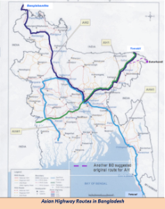
The SAARC Regional Multimodal Transport Study (SRMTS) recommended a number of routes to strengthen connectivity among the countries and territories of North-Eastern sub-region of South Asia. Out of these, the following routes could be opened immediately to facilitate movement of goods and passengers.
- Road Route-1: Petrapole Jashore-Dhaka (via ferry) - Sylhet- Tamabil (Indian border) with a link to Agartala.
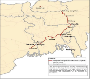
- Road route 2: Kathmandu – Kaharvitta – Phulbari – Banglabandha – Mongla/Chattogram
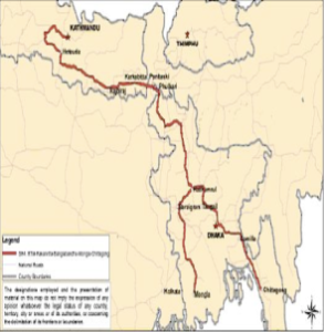
- Road route-3: Thimphu – Phuentsholing – Jaigon – Chengrabandha – Burimari – (i) Chattogram (966 km), and/or (ii) Mongla (880 km)
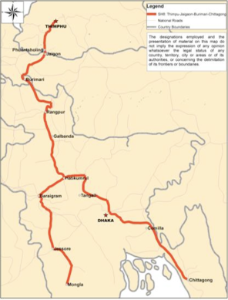
For additional information, please see the following documents:
Note: The information provided in the attached documents, which has been taken from the old DLCA, does not match the structure of the new LCA and is therefore provided separately.
For contact details, please see the following link:
2.4 Bangladesh Railway Assessment
Bangladesh Railway Assessment

Overview
Bangladesh Railway (BR), the state-run transportation agency of the country, who is responsible for operating and maintenance of 2877.10 Km railway line. For smooth operations the Railway network is divided into 2 regions, Eastern and Western. Bangladesh Railway (BR) operates and maintains the entire railway network of the country. BR is headed by the Directorate General of Bangladesh Railway under the Ministry of Railways along with Bangladesh Railway Authority (BRA) which works for policy guidance of BR. To upgrade the services of BR, Railway ministry has newly been established as an independent ministry in 2011 separating it from previous Ministry of Communications.
Railway connected almost all important places of 44 civil districts and plays important role in the economy. It operates Total 348 Passenger trains and 6 Container trains & 20-25 goods trains daily. Besides, it operates the largest Inland Container Depot with capacity of 90,000 TEUs. BR network was initially North-South connection based because of riverine land script. Establishment of new East-West connections and missing links and revival of old and abandon tracks are the key areas of interventions.
Rehabilitation of existing railway lines, modernization of signaling system and acquisition of new rolling stocks to improve the performance and to cop up with the upcoming new situation linking the network with the Trans Asian Railway are the important challenges in front of BR. Apart from these, reducing operational bottlenecks by double tracking all major railway corridors and harmonization of railway tracks by phases, institutional reform, pragmatic role in easing traffic congestion by improving commuter train service in Dhaka and Chattogram cities, proper use of land and other assets, introducing more Public Private Partnership (PPP) in railway sub-sector are important challenges in front of BR.
Key features of BR are the coexistence of several gauges, Broad gauge, Meter gauge and Dual gauge, and the separation of the system by the Jamuna River (Brahmaputra) into a Western and Eastern Zone of operations with only one bridge, the 2003 Jamuna Bridge, connecting the two zones.
Bangladesh Railway operates international, inter-city and suburban rail systems on its multi-gauge network. It also owns coach production facilities. BR is divided into two zones, East & West, each under control of a general manager who is accountable to the Director General of Bangladesh Railway. The two zones have their separate departments for operations, maintenance, and finances. Each zone is divided into two divisions that contain departments of HR, Transportation, Commercial, Finance Mechanical, Way and Works Signaling & Telecommunication, Electrical, Medical, etc. Each zone also has its Workshop Divisions, located at Pahartali and Saidpur, respectively. A locomotive workshop is located at Parbatipur for Broad and Meter gauge locomotives.
BR manages its own Railway Training Academy. A separate Directorate under the Ministry of Railways is charged to inspect and ensure different works of BR in relation to safety and Security. For further details please follow https://railway.portal.gov.bd/.
Bangladesh Railway at a Glance
|
Total Length Railway Line (km) |
2,877.10 |
Total stations |
460 |
|---|---|---|---|
|
Broad Gauge (km) |
659.33 |
Total locomotives |
286 |
|
Meter Gauge (km) |
1,808.05 |
Total coaches |
1507 |
|
Dual Gauge (km) |
409.72 |
Total wagons |
10,226 |
|
Railway Bridges |
3650 |
Mail, Express, Commuter & Demu |
132 |
|
Track Kilometres |
4,093.15 |
Intercity trains |
86 |
|
Number of passenger trains daily |
341 |
Maitree Express (Dhaka-Kolkata) and Bondhon Express (Khulna-Kolkata) |
05 |
|
Number of freight trains daily |
37 |
Local mixed |
126 |
|
Yearly operating revenue (million BDT) |
11,000 |
Approved Manpower |
40,264 |
|
Yearly Passengers carried (millions) |
70 |
Yearly Passenger-Kilometres (million) |
9,000 |
BR Network by Corridor
Bangladesh Railway has documented a Master Plan which is aimed to implement by 2045 and this is prepared in conformity to the 7th 5-year plan, vision 2021 1nd 2014. In that plan the Railway network has been organized by key corridors which are listed below:
|
Corridor 1 |
Dhaka - Chattogram - Cox's Bazar - Deep sea port |
|
|---|---|---|
|
Corridor 2 |
Chilahati - Ishurdi- Khulna – Mongla |
|
|
Corridor 3 |
Dhaka - Bangabandhu Bridge - Darsana/Benapole |
|
|
Corridor 4A |
Dhaka - Bangabandhu Bridge - Rajshahi – Rohanpur |
|
|
4B |
Dhaka - Bangabandhu Bridge - Ishurdi - Parbatipur-Chilahati/Birol |
|
|
Corridor 5 |
Dhaka - Sylhet/Shahbazpur |
|
|
Corridor 6 |
Dhaka - Bangabandhu Bridge- Sirajganj / Roypur (Jamtoil) - Burimari |
|
|
Corridor 7A |
Dhaka - Mawa - Bhanga - Jashore - Khulna – Mongla |
|
|
7B |
Dhaka - Mawa - Bhanga - Jashore – Benapole |
|
|
7C |
Dhaka - Mawa - Bhanga – Barishal |
|
|
7D |
Dhaka - Mawa - Bhanga - Kashiani - Gopalganj - Tungipara |
|
|
Corridor 8A |
Dhaka - Mymensingh - Jamalpur - Tarakandi- Bangabandhu Bridge |
|
|
8B |
Dhaka - Bhairab Bazar – Mymensingh |
|
|
Corridor 9A |
Dhaka - Mawa -Jajira-Rajbari-Moukuri (Mizanpur) - Bara Durgapur (Khas Char) - Pabna – Ishurai |
|
|
9B |
Dhaka - Paturia - Douladia - Moukuri (Mizanpur) - Bara Durgapur (Khas Char) - Pabna – Ishurdi. |
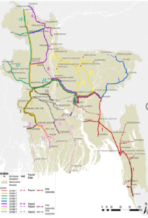
Services of BR
Bangladesh Railway provides various types of services ranging from shuttle for university students to freight and cargo service. Following are the important services of BR:
Passenger Service
Bangladesh Railway is the principal mode of transportation in the country. With the development of road transport facilities there has been a shift in the trend of passenger traffic with short distance passengers preferring road transport, because of their frequent and point to point services. During 2014-2015, about 67 million passengers were transported by Bangladesh Railway against about 65 million during 2013-2014. In order to render better services to the passengers, BR introduced inter-city train services in 1985. At present there are 88 inter-city trains running. Around 40.9% of the total passengers of BR are being carried by the inter-city trains which contribute approximately 83.6 % of the total earning of passenger traffic. To attract the passengers and improve the overall standard of services, BR has introduced different online services along with other developments. At present following services are available on line:
- Online (Internet) Railway E-Ticketing Service
- Train Tracking Monitoring System
- Train Information display System
- Ticket buy/booking through SMS
- Computer Ticketing & Seat Reservation System
Maitree and Bondhon Express
The Maitree and Bondhon Express are international trains. Maitree Express has been in operation since 2008 linking Dhaka and Kolkata, India while Bondhon Express has linked linking Khulna and Kolkata since 2018.
Freight and Cargo services
The railway has been facing tough competition with other modes of transport for the high rated traffic, which pay more revenue. On the other hand, the railway is called upon to carry traditional low rated essentials. As a national carrier, BR has an obligation to carry essential commodities like food grains, fertilizer, jute, cement, coal, iron and steel, stone & boulders, petroleum products, salt, sugar etc. to the remote corners of the country at a cheaper rate. BR has experienced negative growth in freight traffic in last few decades due to poor services and facilities and dramatic developments in road and river transportation routes. At present the BR has following different types of wagons for carrying freight:
|
Bogie Cover Wagon (each 34 MT capacity) |
250/500 |
|---|---|
|
BFCT |
450/900 |
|
BKh/Hooper |
100/200 |
|
BKC |
120/240 |
|
|
Bangladesh Railway transports containers from Chattogram to Dhaka. Special type flat wagons required for container movement were initially arranged by converting some existing wagons. Subsequently 80 bogie container flats were procured from China and another 100 bogie container flats were procured from India. An Inland Container Depot has been opened at Dhaka with custom and port facilities for clearance of container traffic. Exclusive container trains were introduced on 5 August 1991. Since then, volume of container traffic gained a momentum but BR is yet to catch up with road and water transportation facilities.
At present there is only one Inland Container Depot (ICD) at Kamlapur, Dhaka which is connected by Rail, which is insufficient to carry future loads. At present approximately 75-80 thousand containers are being handled by BR between CPA and ICD Kamlapur. Another ICD is under process of establishment at Dhirasram, north of Tongi and just south of Joydevpur. It will be 264 km only from Chattogram, whereas distance of Kamlapur is 321 km from Chattogram. It is expected that Dhirasram ICD will be able handle 500,000 TEU yearly. Pangaon river port / ICD is running with minimum capacity being underutilized as it is used by few inland ships only who carry containers from Chattogram to Pangaon, but once Padma Bridge is operational, this ICD will be connected by rail and it will be a hub between Dhaka and South Bengal and India through Benapole Land Port.
|
Container holding capacity |
4067 TEUs |
|---|---|
|
Yard area |
1 36 954 Sq. m |
|
Container Freight Stations (CFS) |
8000 Sq. m |
|
Weighbridge |
2 in Two gates |
|
Equipment |
Reach Stackers-2 (45 MT), Forklifts-4 (42 MT), Reach Stacker-1 (7 MT), Low Mast Forklift-6 (3 MT), Tractor Trailors-8. |
|
Wagons for container transportation |
550 |
|
Railway terminal (Length of two tracks) |
1097 m |
|
Fire brigade |
1 Unit |
List of Officers
| Name | Designation | Phone No. | |
|---|---|---|---|
|
Md. Shamsuzzaman |
Director General |
9561200 |
|
|
Nasir Uddin Ahmed |
General Manager (East) |
843200 |
|
|
Khandker Shahidul Islam |
General Manager (West) |
761576 |
|
|
Md. Anowarul Hoque |
Addl. Director General (Infra) |
9562051 |
|
|
Syed Faruk Ahmed |
Addl. Director General (RS) |
9563450 |
|
|
Md. Miah Jahan |
Addl. Director General (OP) |
9562030 |
|
|
Chandan Kanti Das |
Addl. Director General (M & CP) |
9563539 |
|
|
Md. Johurul Islam |
Addl. Director General (Finance) |
9562047 |
|
|
Dr. Luthfunnahar Begum |
Chief Medical Officer (East) |
843165 |
|
|
S.A.M. Imtiaz Babul |
Chief Medical Officer (West) |
776379 |
|
|
Md. Mizanur Rahman |
Chief Mechanical Engineer (East) |
843154 |
|
|
Mrinal Kanti Banik |
Chief Mechanical Engineer (West) |
761948 |
|
|
S. M. Murad Hossain |
Chief Commercial Manager (East) |
2863191 |
|
|
Farid Ahmed |
Controller of Stores |
843135 |
|
|
F.M. Mahiuddin |
Divisional Superintendent (Workshop) |
2566253 |
|
|
Md. Burhan Uddin |
Divisional Railway Manager, Chattogram |
843182 |
|
|
A Am Salah Uddin |
Divisional Railway Manager, Dhaka |
9330522 |
|
|
A.M.M. Shahnewaj |
Chief Commercial Manager (West) |
761091 |
|
|
Md. Shahidul Islam |
Chief Personnel Officer (West) |
760594 |
|
|
Md. Ahsan Ullah Bhyuain |
Divisional Railway Manager, Paksey |
63496 |
|
|
Md Shofiqur Rahman |
Divisional Railway Manager, Lalmonirhat |
61353 |
|
|
Md. Joidul Islam |
Divisional Superintendent, Saidpur |
2136 |
Station Managers
|
Station |
Phone No. |
Station |
Phone No |
|---|---|---|---|
|
Station Manager - Dhaka |
01711691612 |
Divisional Railway Manager - Dhaka |
01711506137 |
|
Station Manager - Chattogram |
01711691550 |
Divisional Railway Manager - Chattogram |
01711506138 |
|
Station Manager - Sylhet |
01711691656 |
Divisional Railway Manager - Paksey |
01711506130 |
|
Station Superintendent - Rajshahi |
01711622728 |
Divisional Railway Manager - Lalmonirhat |
01711506136 |
|
Area Operating Manager - ICD / Dhaka |
01711691628 |
|
|
Contact Information of Important Railway Stations
|
Station Name |
Phone |
Station Name |
Phone |
Station Name |
Phone |
|---|---|---|---|---|---|
|
Dhaka |
02 – 9358634 02 - 8315857 |
Potia |
03035 – 56528 |
Joypurhat |
0571 – 62304 |
|
Tejgaon |
02 - 9112007 |
Hathazari |
03023 - 2601061 |
Bogura |
051 – 65042 |
|
Dhaka Cantonment |
02 - 9860761 |
Shayestaganj |
0831 – 56646 |
Bonarpara |
05750 – 64018 |
|
Dhaka Airport |
02 - 8924239 |
Sreemangal |
08626 – 71350 |
Gaibandha |
05750 – 61338 |
|
Tongi |
02 - 9801058 |
Kulaura |
08624 – 56004 |
Rangpur |
0521 – 63006 |
|
Ghorashal |
06254 - 74206 |
Sylhet |
0821 - 716061, 0821 – 713990 |
Kurigram |
0 581 – 61366 |
|
Jinardi |
30250 - 62046 |
Habiganj |
0831 – 52260 |
Thakurgaon |
0561 – 52097 |
|
Bhairab Bazar |
9424 - 71477 |
Kishoreganj |
0941 – 55245 |
Nilphamari |
0551 – 61229 |
|
Brahmanbaria |
0851 - 52006 |
Mymensingh |
091 – 55700 091 - 55667 |
Saidpur |
05526 – 2104 |
|
Ashugonj |
08528 - 74221 |
Jamalpur |
0981 – 63040 |
Kushtia |
071 – 53058 |
|
Narsingdi |
0628 - 62046 |
Rajshahi |
0721 - 774043 0721 – 776040 |
Kushtia Court |
071 – 53065 |
|
Akhaura |
08522 - 56012 |
Chapai Nawabganj |
0781 – 55205 |
Rajbari |
0641 – 65223 |
|
Cumilla |
081 - 76358, 081 - 76353 |
Rohanpur |
07823 – 74013 |
Jashore |
0421 – 65019 |
|
Chandpur |
0841 - 63255 |
Rajshahi court |
0721 – 774122 |
Benapole |
04228 – 75501 |
|
Feni |
0331 - 74875 |
Natore |
0771 – 66923 |
Khulna |
041 – 760691 |
|
Chattogram |
031 - 635162, 031 - 616366 |
|
|
|
|
Main stations / gauge
|
Eastern Zone |
Western Zone |
|||
|---|---|---|---|---|
|
Khulna |
Broad gauge |
Birampur |
Dhaka Komlapur |
Dual gauge |
|
Daulotpur |
|
Phulbari |
Dhaka Airport |
|
|
Phultala |
|
Parbotipur Jn |
Dhaka Cantonment |
|
|
Noapara |
|
Dinajpur |
Tongi Junction |
Dual Gauge |
|
Jashore Jn |
Broad guage |
Panchogorh |
Joydevpur Junction |
Dual gauge |
|
Kotchandpur |
|
Syedpur |
Tangail |
Dual gauge |
|
Darshana |
Broad gauge |
Nilphamari |
Bongobondhu Setu East |
Dual gauge |
|
Alamdanga |
|
Domar |
Mymenshingh |
|
|
Cuadanaga |
|
Chilahati |
Jamalpur Junction |
|
|
Poradoho Jn |
Broad gauge |
Rangpur |
Jogonnatgonj Ghat |
|
|
Mirpur |
|
Kaunia Jn |
Dewangonj |
|
|
Bheramara |
|
Lalmonirhat |
Bahadurabad |
|
|
Pakshi |
|
Peergacha |
Kishorgonj |
|
|
Ishawrdi jn |
Broad gauge |
Bamondanga |
Mohongonj |
|
|
Ishawardi Bypass |
Dual gauge |
Gaibandha |
Chattogram |
Meter gauge |
|
Abdulpur Junction |
Dual Gauge |
Bonarpara |
Sylhet |
|
|
Rajshahi |
|
Bogura |
Akhaura Junction |
Meter auge |
|
Amnura Junction |
|
Chatmohor |
B.Baria Junction |
|
|
Capainababgoinj |
|
Ullapara |
Cumilla |
|
|
Natore |
|
Jamtoil |
Luksam Junction |
|
|
Madhnagar |
|
Sirajgonj Bazar |
Nagolkot |
|
|
Ahsangonj |
|
Sd Monsur Ali |
Hassanpur |
|
|
Shantahar |
Dual Gauge |
Bongobondhu Setu West |
Feni |
|
|
Akkelpur |
|
|
Sitakundo |
|
|
Joypurhat |
|
|
Pahartali |
|
|
Pacbibi |
|
|
Bottali |
|
|
Hili |
|
|
Norosingdi |
|
Development Progress of BR
Since 2009, Bangladesh Railway has newly constructed 330.15 km of rail lines, 91 station buildings, 295 bridges and converted 248.50 km railway tracks into dual gauge tracks. Furthermore, 1,335.23 km railway track, 644 bridges, 177 station buildings, 430 passenger coaches, 277 wagons have been rehabilitated. To address the shortage of rolling stocks, 20 MG locomotives, 26 BG locomotives, 270 passenger coaches and 20 sets DEMU, 165 BG and 81 MG tank wagons, 270 Flat wagons and 30 Brake vans have been procured.
BR has started to construct double line in the important corridor of Dhaka-Chattogram which is 321 km, of which 118 km is double line.
The government has taken various projects for construction of the broad-gauge double line and for conversion of the meter gauge rail line to dual gauge line under the 1st, 2nd and 3rd LoC (Indian Line of Credit). Besides, two projects for construction of dual gauge rail line parallel to the exting dual gauge line of Ishurdi-Joydebpur section and dual gauge line parallel to existing meter gauge line of Joydevpur-Mymensing-Jamalpur Section have been finalised with the financing of Chinese government.
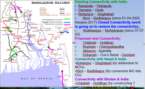
Furthermore, as a part of long-term planning, BR has prepared a Railway Master Plan with the grant assistance of ADB. The updated Railway Master Plan has been approved by government in January 2018. A total of 230 projects at the cost of BDT.5,53,662 crore have been included in the newly approved Railway Master Plan to be implemented in six phases over the period spanning from July 2016 to June 2045. Some of the High Prioritised Projects of BR are shown below:
|
Sl |
Project Name |
Project Cost (BDT) |
Phase Period |
|---|---|---|---|
|
1. |
Bangabandhu Railway Bridge Construction |
9740 |
2018-2020 |
|
2. |
Construction of Rail Line from Bhanga Junction (Faridpur) to Payra Port Via Barisal |
28335 |
2018-2020 |
|
3. |
Construction of Akhaura-Agartala Dual gauge railway link |
478 |
2018-2020 |
|
4. |
Conversion of existing MG track to DG track between Akhaura-Sylhet |
8619 |
2018-2020 |
|
5. |
Construction of DG Rail Link from Bogura to Shaheed Monsur Ali Station |
6607 |
2018-2020 |
|
6. |
Construction of double line between Joydebpur and Ishurdi section of BR |
7698 |
2018-2020 |
|
7. |
Construction of a Dual Gauge Rail Line Parallel to the Existing Meter Gauge in Joydebpur- Maymensingh-Jamalpur Section. |
7698 |
0218-2020 |
|
8. |
Modernization of Parbatipur Central Locomotive Workshop |
770 |
2018-2020 |
|
9. |
Construction of new locomotive workshop at Narayanganj |
770 |
2018-2020 |
|
10. |
Construction of Repair & Maintenance Workshop for DEMU at Narayanganj |
963 |
2018-2020 |
|
11. |
Reconstruction of Diesel Loco sheds (09 total) including Equipment upgrade and DG Conversion |
3500 |
2018-2020 |
|
12. |
Construction of a new Inland Container Depot (ICD) near Dhirasram railway station |
1640 |
2018-2020 |
|
13. |
Rehabilitation of Jashore-Benapole rail line |
1502 |
2018-2020 |
|
14. |
Procurement of 40 Broad Gauge Locomotives |
2070 |
2018-2020 |
|
15. |
Procurement of 400 MG & 300 nos BG covered vans (BC) and 180 MG & 120 BG Bogie Open Wagons (BKC) for BR |
1140 |
2018-2020 |
|
16. |
Construction of overpass/flyover in Narayanganj - Joydebpur section of Bangladesh Railway |
591 |
2021-2025 |
|
17. |
Construction of Dhaka- Chattogram High Speed Railway |
30995 |
2021-2025 |
|
18. |
Conversion of existing Metre Gauge double line to Dual Gauge double line between Tongi – Bhairab. |
6233 |
2021-2025 |
|
19. |
Construction of Chattogram CGPY Inter-Modal Terminal |
1200 |
2021-2025 |
|
20. |
Conversion of Metre Gauge double line into Dual Gauge double line between Bhairab Bazar and Akhaura including rebuilding of existing Bhairab and Titas Bridge |
3214 |
2021-2025 |
Ongoing Projects of BR
After inclusion of railway tracks over the Bangabandhu Bridge, a railway link between East and West Zone has been established. The Government, underscoring the need for railway communication, attaches topmost priority to railway amongst all the surface mode of transports in Vision-2021. A good number of new projects have been approved for the improvement of railway. The projects have already been taken in hand for expansion, upgradation, renovation, conversion and modernisation of railway network. Moreover, rail line rehabilitation, construction of a new ICD at Dhirasram, modernization of Saidpur workshop, modernization of stations, procurement of relief cranes, establishment of load monitoring device in Bangabandhu bridge and on different important places have been undertaken against approved projects. To meet the expectation of the stakeholders necessary steps have been taken for doubling Dhaka- Chattogram railway corridor and introduction of rail communication over the Padma Bridge. Bangladesh signed the “Intergovernmental Agreement on the Trans-Asian Railway (TAR) Network”. Steps have been taken to establish Trans-Asian Railway Network and Regional/sub-regional connectivity in Bangladesh. Moreover, to meet the traffic demand New Express connections have been introduced.
The Government is committed to transform BR into a feasible and market oriented organization with managerial, financial and administrative autonomy to meet its objectives. To prepare this ground, the Asian Development Bank (ADB) supported a Technical Assistance Project which consisted of three phases. Few of the ongoing projects are shown below:
- Construction of the single line on the Dual gauge track from Duhazari to Cox's Bazar via Ramu and Ramu to Gundum of Myanmar (to be completed by 2022).
- Construction of railway line from Khulna to Mongla Port (To be completed by 2020).
- Renovation Work of Bangladesh Railway Kulaura-Shahbazpur sections (To be completed by 2030).
- Collection of 70-meter gauge diesel electric locomotive for Bangladesh Railway (by 2024).
- Construction of dual gauge double Line (1st Amendment) in the 3rd and 4th dual gauge line of Dhaka-Tongi section of Bangladesh Railway and Tongi-Jaydebpur sections. (To be completed by 2019).
- Construction of the double railway line from Akhaura to Laksam and the conversion of existing rail lines into Dual Gauge (To be completed by 2020).
- Construction of a Dual Gauge rail line parallel to the existing Meter gauge rail lines in Dhaka-Narayanganj section (To be completed by 2020).
- Rehabilitation and quality improvement of the level crossing gates of the eastern part of Bangladesh Railway (1st Amendment). (To be completed by 2020).
- Rehabilitation and quality improvement of the level crossing gates of the western region of Bangladesh Railways. (To be completed by 2020).
- Collection of Meter gauge and Broad-gauge passenger carriage for Bangladesh Railway (To be completed by 2030).
- Collection of locomotives, relief cranes and locomotive simulators for Bangladesh Railway (To be completed by 2020).
- Establishment of Padma Bridge Rail Link (1st Amendment) (To be completed by 2024).
- 200 Meter gauge passenger carriage collection for Bangladesh Railway (To be completed by 2020).
- Construction of Akhaura-Agartala dual gauge Rail Link (Bangladesh part) (To be completed by 2020).
- Renovation of Bangabandhu Sheikh Mujib railway Bridge (To be completed by 2020).
- Collection of 20 Meter gauge locomotive and 150 Meter gauge passenger carriage for Bangladesh Railway (To be completed by 2021).
- Feasibility review Programme for construction of Circular railway around Dhaka city (To be completed by 2019).
- Conversion of Meter gauge into Dual Gauge line from Parbatipur to Kownia (To be completed by 2022).
- Feasibility review of important Western projects (To be completed by 2030).
- Construction of the Broad-gauge Railway from Madhukhali to Magura city via Kamerkhali (To be completed by 2022).
- Development of rolling stock operations of Bangladesh Railways (rolling stock collection) (To be completed by 2021).
- Construction of double line railway at Khulna junction of Bangladesh Railway (To be completed by 2022).
- Rail line renovation and construction including signalling for Rooppur nuclear power plant.
- Construction of Broad-gauge railway between Chilahati and Chilahati border with India is aimed at establishing rail connectivity. (To be completed by 2021).
- Construction of new Dual gauge railway station at Bogura to memoir Shaheed M Mansur Ali (To be completed by 2023).
- Construction of double line from Joydebpur to Ishhurdi (To be completed by 2024).
- Feasibility review and detailed design for the railway connection at Sunamganj District headquarter (To be completed by 2020).
- Conversion of the Meter gauge railway line of the Akhaura-Sylhet segment into dual gauge (To be completed by 2025).
- Construction of High-speed train line between Dhaka and Chattogram.
Development as per Master Plan
|
Phase |
No of Projects |
Project Value (In USD millions) |
Remarks |
|---|---|---|---|
|
Completed Projects 2010-2015 (Existing MP) |
25 |
513.97 |
|
|
Ongoing Projects 2016-2020 (Existing MP) |
36 |
1644.23 |
Investment Project-29 Ta Projects-07 (24.81) |
|
Phase-I: 2016-2020 |
76 |
18696.12 |
20 Nos Gauge Conversion Projects 39 Nos Rs Related Projects |
|
Phase-Ii: 2021-2025 |
63 |
14946.62 |
|
|
Phase-Iii: 2026-2030 |
30 |
10744.50 |
|
|
Phase-Iv: 2031-2035 |
22 |
12068.85 |
|
|
Phase-V: 2036-2040 |
12 |
10300.75 |
|
|
Phase-Vi: 2041-2045 |
4 |
1365.00 |
Performance and Constraints of BR
Performance of BR
|
Fiscal Year |
Passenger Km (Million) |
Freight Ton Km (Million) |
Total operating revenue (BDT. in crore) |
Total operating expense (BDT. in crore) |
|---|---|---|---|---|
|
2009-10 |
7305.00 |
710.00 |
673.16 |
1257.20 |
|
2010-11 |
8051.92 |
692.64 |
747.70 |
1491.82 |
|
2011-12 |
8787.23 |
582.11 |
726.42 |
1567.12 |
|
2012-13 |
8253.00 |
525.00 |
804.26 |
1562.38 |
|
2013-14 |
8135.00 |
677.35 |
800.17 |
1601.69 |
|
2014-15 |
8711.36 |
693.84 |
935.45 |
1808.29 |
|
2015-16 |
9167.18 |
675.09 |
904.02 |
2229.22 |
|
2016-17 |
10040.66 |
1052.67 |
130.37 |
2835.52 |
|
2017-18* |
10040.66 |
1052.67 |
130.37 |
2835.52 |
Constraints of BR
Major constraints in rail connectivity are the lack of connectivity between the rail networks, including differences of the rail gauges and incompatibilities in rolling stock. A through link is not available between the main part of India and the north-east states through Bangladesh. India has a three gauge system while Bangladesh has broad gauge and meter gauge (MG) with some dual gauge in the west and MG only in the east. India adopts air-braked rolling stock whereas Bangladesh adopts vacuum based with some air-braked. The key issue is overall deteriorated conditions of rail networks, especially in eastern India and Bangladesh.
The rail network has been neglected for a long time without adequate budget to provide for much needed maintenance and/or improvement. As a result, the infrastructure is generally in poor condition with a number of inadequacies, such as short loop lengths, marshalling yard lines and terminals restricting the ability of locomotives to haul full train loads. Mechanical signaling and track structures further restrict freight train speeds. Apart from about 900 km of main line, lines and crossing loops are in bad condition leading to frequent derailments.
The funding constraints are further compounded with Bangladesh Railways (BR) required to operate extensive passenger services at low fares. This results in insufficient revenue to justify investment, despite the high passenger demand. The priority given to passenger trains also causes delays to freight trains and reduces their competitiveness. This is a particular problem where lines are single track.
The funding problems have been recognized by the Government and in the Bangladesh Railway Investment Program 2007–13 the main agreed projects are duplication of the Tongi-Bharaib Bazaar section, rehabilitation of rail lines, remodeling/rehabilitation of railway stations, signaling and procurement of locomotives and carriages/wagons. In addition, both ADB and the World Bank have assistance programs aimed at improving track and wagon maintenance.
BR rolling stock is poorly maintained and most is overdue for repair or beyond its economic life. BR policy is to move towards air-braked stock, but a considerable amount of unbraked rolling stock remains and this can only be hauled at a slow speed, dramatically reducing effective track capacity. The amount of unbraked stock also limits the number of trains that can use the Jamuna Bridge. Theft of brake blocks and other equipment thwarts attempts to upgrade stock and the generally poor condition of the rolling stock restricts possible train speeds.
While some locomotives are fitted to haul both vacuum and air-braked stock, unavailability of suitable locomotives at Darsana and Benapole has been cited as a reason for limiting the types of wagons used on the international route to vacuum-braked stock. The average turnaround time for Indian wagons bringing goods into Bangladesh is five to six days for an average movement of only 70 km. The turnaround time is considered excessive for this relatively short movement and a source of friction with Indian Railways.
A new dual gauge link between Ishurdi Junction and Dhaka Cantonment station provides a broad gauge (BG) link with India from the outskirts of Dhaka, but restrictions imposed by the Jamuna Multipurpose Bridge Authority (JMBA) to prevent the movement of Indian BG wagons over this bridge. Re-rating the bridge, possibly involving bridge strengthening, is being investigated by ADB but the cost of such strengthening is expected to be quite high. Other options including weighbridges to ensure wagons are within allowable limits have so far been rejected by JMBA.
The route between India through to Myanmar and its northeastern states could be shortened if movement through Bangladesh was negotiated satisfactorily. The main route would be from Darsana to Akhaura or Shahbazpur via Ishurdi and Tongi junction. However, there would need to be the transshipment for freight between BG and MG at some point between Ishurdi and Tongi. However, it is recognized that both countries do not consider such a through route as a priority.
Security Arrangements of BR
To ensure the property of Bangladesh Railway and to ensure safety and security of the passengers and freight different measures have been adopted. They are:
Government Railway Police (GRP)
Prevention and detection of crime committed against passengers traveling by train and their properties and also maintenance of law and order in the Railway premises are the direct responsibilities of the Railway Police working under the control of National Police Headquarters as well as Ministry of Home Affairs. The general duties of the staff and jurisdiction of Railway Police have been enumerated in the Police Regulation of Bengal 1943. Their duties are:
- Control of passenger traffic inside the station premises more particularly on the platforms, in the booking office, waiting halls at the entrance and exit gates and wherever specially required on emergency by the station officials.
- The control of vehicular and other traffic in the station compound.
- The maintenance of law and order at stations and in standing passengers’ trains, prevention of over crowding
- Watching loaded passenger trains when standing in the station.
- The arrest of those found committing nuisances or suffering from infectious disease and keeping the station premises clear of idlers and beggars.
- The examination of all empty carriages on arrival at terminal station for property left behind by passengers and to see that carriage fittings have not been tampered with:
- The removal of bodies and persons dying in the train and on station premises and the conveyance to hospital of the sick people.
- Investigation into cognizable offences committed with railway limits and prevention of the same.
- The arrest offenders in cognizable cases and detention of them in custody as well as persons arrested by Railway Officers and made over to the police, and their production before the Magistrate.
- The reporting of non-cognizable case or infringement of bye-laws of the line to proper authorities as also all instances of oppression or fraud on the part of Railway sub-ordinates or others.
- The prosecution of cognizable case as well as non-cognizable cases under Railway act, 1890 on behalf of the management.
Railway Nirapatta Bahini (RNB)
Railway Nirapatta Bahini is guided by RNB Ordinance-1976 under the railway administration. The responsibility of providing security to the Railway men, Railway properties and the properties entrusted to it for carrying falls under the duties of Railway Nirapatta Bahini (RNB) Railway Nirapatta Bahini is responsible for:
- Prevention and detection of crime on the Railway.
- Protection and safeguarding the Railway properties.
- Removing any obstruction in the movement of Railway, its properties and the properties entrusted to it for carriage.
- Escorting of cash movement and protecting pay officers of the railway.
- Providing security to the goods trains and luggage & Parcel vans of passenger trains.
- Assisting during Block Check and mobile Court.
- Eviction of unauthorized occupants in the railway premises, under command of Railway Estate officer/Magistrate.
International Corridors Leading to Bangladesh
Overview
Bangladesh has the potential to become a transport and transshipment center for the sub-region. It borders India and Myanmar and is geographically close to Bhutan, Nepal, and Kunming—the key transportation hub in southwest People’s Republic of China (PRC). With the opening of the Payra Sea port and Padma Bridge, the Dhaka–Chattogram, Dhaka-Mongla and Dkaka-Payra transport corridor and other strategic transport corridors will facilitate trade of Bangladesh India, Myanmar, Bhutan and Nepal including other countries in Asia, thereby attracting more foreign and domestic traffic to the country.
South Asia is the least integrated region and the cost of trading across borders is one of the highest in the world. Co-operation with its neighboring countries offers benefits to Bangladeshi owned road, rail and water transport services and port services. Opening up Chattogram or Mongla Port will earn huge revenue for Bangladesh. Similarly, such benefits could be realized if the Government offer Bhutan, Nepal and the North-East India states, the opportunity to transit through Bangladesh to reach the heartland of India, in exchange for the right of Bangladeshi truck and river vessel operators and Bangladesh Railways to share in this traffic.
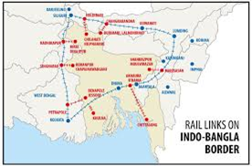
Integrating the transport network of South Asia is important to Nepal, Bhutan, and regions such as northeast India as it will end their landlocked or semi-isolated status. Within such a framework, Nepal, Bhutan, and the northeastern region of India would have the benefit of improved access to the ports and important economic centers of the region, and a choice of routes and modes.
Given the large potential for reduction in transportation costs, allowing the landlocked region of North-Eastern India, Bhutan, and Nepal access to Chattogram port through Bangladesh’s eastern border or to Mongla port through its North-Western border has been a key issue among concerned authorities, although no tangible result has been reached yet.
Recent studies proposes 7 corridors for bi-lateral trade between Bangladesh and its neighbors (Northeast India, heartland India, Bhutan and Nepal), as well as for transit allowing each neighbor to shorten circuitous travel today via the ‘chicken neck’ between Northeast India and the rest of India. Such transit can go by road, rail or water. Water and rail transport have a cost advantage for bulks (i.e. most exports), whereas high-value goods (mainly imports) are likely to prefer road. The study lists physical and nonphysical barriers to the development of each corridor and recommends actions and investments that will be needed in the short and medium terms to overcome these barriers.
Cross-border exchanges of railway freight wagons also require agreement on how to keep track of the wagons while they are in ‘foreign’ territory and the relevant charges to be levied. BR wagons do not meet Indian Railways’ standards (notably their brake systems), but IR wagons can operate in Bangladesh; BR would at least earn track use charges from such traffic. The mix of track gauges also complicates things.
Indian freight trains travel only up to the border stations inside Bangladesh and Bangladesh Railway (BR) locomotives then pull the Indian wagons up to a short distance inside the country where transshipment takes place. BR wagons also do not cross the Indian border, as the rolling stock is incompatible with the air-braked stock of Indian Railways. Present load restriction over Jamuna Bridge in Bangladesh prohibits the movement of broad gauge fully loaded wagons across the bridge, although a dual gauge railway network now exists up to Dhaka. Recent investigation, however, revealed that ISO containers on low platform BLCA/BLCB flat cars having a floor height of 1009 mm can be allowed over Jamuna Bridge, without any load restrictions.
Trans-Asian Railway (TAR) through Bangladesh
The dream of connecting Bangladesh to the much- discussed trans-Asian railway network is finally on the way to reality. Bangladesh gov is in the process of infrastructural development for implementation of the railway network to get connected with the Trans Asian Railway. Once the railway network is implemented, Bangladesh will be connected to Myanmar, India, Thailand, China, Vietnam, Singapore, Cambodia and South Korean railway network. The railway network connecting Bangladesh with the International World is the commercial-Economic Corridor. In particular, Bangladesh is one of the most important trade-economic Partners of China and the possibility of rail communication with Singapore is a landmark in Bangladesh's foreign trade. In accordance with the government 's accepted roadmap, the project has been scheduled to be completed by 2022. In this connection a new railway network of about 101 kilometres from Dohajari to Cox's Bazar via Ramu and Ramu to Ghundhum of Myanmar is taken for the implementation with priority. At present the Chattogram-Cox's Bazar-Ghundum rail line is now going on and it will be connected with the Trans-Asian Railway Network.
Initially the rail line will connect with neighbouring Myanmar via Ghundum and it will eventually be expanded up to China, Malaysia and Thailand as part of the Trans-Asian Railway Network. The govt has also decided that another project will be undertaken to install rail line connecting Agartala in Tripura, an Indian state, with Bangladesh via Akhaura. Besides, all the disrupted railway routes with India will be revived. Five TAR links have been nominated for Bangladesh.
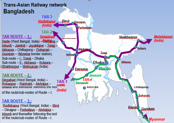
Focusing on a few strategic routes (see detailed map under)
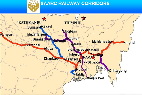
The SAARC Regional Multimodal Transport Study (SRMTS) recommended a number of routes to strengthen connectivity among the countries and territories of North-Eastern sub-region of South Asia. Out of these, the following Rail routes could be opened immediately to facilitate movement of goods and passengers:
SAARC Railway Corridors
Following SAARC railway corridors passes through Bangladesh (as per SAARC Regional Railways Agreement):
- Pakistan-India-Bangladesh-India
Lahore (Pakistan)-Wagah (Pakistan)-Atari (India)-Delhi Kolkata (I)-Gede/Petrapol (I)-Darshana/Benapol (Bangladesh)-Dhaka (Bangladesh)-Shahbazpur (Bangladesh)-Maishashan (India)–Imphal (India).
Lahore (Pakistan) - Wagha (Pakistan) - Atari (India)-Delhi (India)- Kolkata(India)-Gede/Petrapol (India) - Darshana /Benapol (Bangladesh)–Dhaka(Bangladesh)-Akhaura/ Gangasagar (Bangladesh) - Agartala (India)
- India-Bangladesh
Imphal (India) - Agartala (India) – Akhaura/Gangasagar (Bangladesh) – Chattogram Port (Bangladesh)
- Nepal-India-Bangladesh
Birgunj (Nepal) – Raxaul (India) - Singhabad (India) - Rohanpur (BD) - Mongla Port/ Chattogram Port (BD)
Biratnagar (Nepal) - Jogbani (India) - Radhikapur (India) - Birol (Bangladesh) -Khulna (BD) - Mongla Port (BD).
Bardibas(Nepal) – Inarwa (Nepal) - Jaynagar (India) - Radhikapur (India) - Birol (Bangladesh) – Khulna (Bangladesh) -Mongla Port (Bangladesh).
- Bangladesh-Bhutan
Mongla Port/Chattogram Port (Bangladesh) - Chilahati (Bangladesh) - Haldibari (India) – Hasimara (India) - Bhutan.
For information on Bangladesh Railway Network Additional Information, please see the following documents:
Bangladesh Railway Network Additional Information
Bangladesh Railways
additional info
Note: The information provided in the attached documents, which has been taken from the old DLCA, does not match the structure of the new LCA and is therefore provided separately.
For information on Bangladesh Railway Network contact Information, please see the following link:
2.5 Bangladesh Waterways Assessment

Overview
Bangladesh being a country with many rivers, Inland Water Transport (IWT) is a major mode for the transport of goods and people. IWT is the cheapest mode of transport compared to road or rail. Until recently, however, the sector had received little attention from the Government of Bangladesh with only limited resources allocated to its development. In addition, these resources were mostly used to develop the main routes (the ones most used by large mechanized vessels) while secondary rivers and transport using country boats (mainly rural and until recently non-mechanized vessels constructed in traditional design) were given second priority.
The total length of rivers in Bangladesh is estimated to be in the range of some 24,000 kilometres, providing a very high degree of penetration. Out of this total, 6,000 kilometres are accessible for movement of modern mechanized vessels during the monsoon season, and out of this, some 3,800 kilometres are navigable around the year. Country boats, in the number of several hundred thousands, are traditional vessels which have been plying inland and coastal waters for hundreds of years and which play a key role as a rural mode of transport of goods and people. Inland ports and other facilities include 11 major inland ports, 23 coastal island ports, 133 launch stations and more than 1,000 minor landing points located in rural areas.
|
Length of inland waterways |
24,000 km |
|---|---|
|
Length of navigable waterways |
Monsoon: 5,968 km Dry season: 3,865 km |
|
Least available depth range |
3.90 m to 1.50 m |
|
Annual water discharge (Source: BWDB) |
1400 billion cubic meter |
|
Annual quantum of silt (Source: BWDB) |
2.5 billion tons |
|
No. of passenger carried (In year) |
87.80 million |
|
Quantum of cargo carried (In year) Total manpower- 1682 |
58 million tons |
During emergencies, there is little probability that it will be used by agencies, being too slow compared to road or helicopter deliveries. Nevertheless at local level, it is probable that many remote areas will – in the initial phases – only be reachable by IWT / coastal sea-trucks.
Navigable River Routes
Both Bangladesh Inland Water Transport Authority (BIWTA) and Corporation (BIWTC) provide pilotage facilities to about 7,000 inland water vessels. They regulate the movement of about 2000 passenger launches and maintains 22 inland ports along with about 800 launch ghats including terminals. Approximate 6000 km Navigable River route is further classified into following 4 categories by BIWTA depending on the drought and clearance:
|
Class |
Minimum Draught |
Length & % |
Minimum Vertical Clearance |
Minimum Horizontal Clearance |
Remarks |
|---|---|---|---|---|---|
|
Class- I |
3.66 m |
683 km (11%) |
18.30 m |
76.22 m |
Least Available Draft (LAD) of 3.6 m required to be maintained round the year. |
|
Class- II |
2.13 m |
1000 km (17%) |
12.20 m |
76.22 m |
Links major inland ports or place of economic importance to class I routes |
|
Class –III |
1.52 m |
1885 km (32%) |
7.62 m |
30.48 m |
Being seasonal in nature, it is not feasible to maintain higher LAD throughout the year |
|
Class –IV |
Less than 1.52 m |
2400 km (40%) |
5.00 m |
20.00 m |
These are seasonal routes where maintenance of LAD of 1.5m or more in dry season not feasible |
|
Total |
5968 km |
||||
BIWTC is facilitating passenger and cargo movement in the inland waterways and also offshore islands in the public sector vis-à-vis private sectors. It is operating 35 ferries in different routes. On the other hand, ocean shipping performs 80% of the export-import trade. A WB study reveals that IWT has been the least expensive mode of transport, than that of rail and road. As such, considering the facts of land-man ratio and scarcity of land for further expansion of road networks in the country, IWT sub-sector has given the outmost importance specially dredging various river routes for making them navigable round the year. To develop a balanced and cheap transport system in Bangladesh, it is important to improve IWT both from infrastructure and technological points of view. IWT sub-sector suffers from (i) siltation problem in inland waterways, (ii) day & night navigational problem of waterways, (iii) shortage of passenger & cargo handling facilities including transit shed at river ports, (iv) Presence of manual loading/unloading of cargo at river ports, (v) underdeveloped rural launch landing stations, inadequate number of water crafts both for river and ocean going etc. Moreover, for transportation of containers by inland waterways to and from two seaports, the container handling facilities have not yet been developed. Decades of insufficient investment, and challenged governance Ltd the development of the port sector of the country.
Due to geographical position and topological condition of the country rivers are becoming more and more narrow and thin by siltation. As such, implementation of comprehensive capital dredging program is the biggest challenge for the IWT sub-sector. Specific challenges identified in the sub-sector are: (i) channeling of the existing waterways through massive dredging and procurement of dredgers, (ii) construction of deep sea port to streamline international trade; (iii) improvement of day and night navigation for water crafts by providing navigational aids; and (iv) construction of inland container river port for transportation of containers by waterways to/from sea ports etc.
Transportation Through Waterways
BIWTA and corporation BIWTC are the 2 main players of the government which keeps the inland waterways navigable and safe for smooth transportation of cargo and passengers. IWT continues to be an important mode of transport not only in the inland movement of freight and passengers but also in the transportation of import and export items through the ports of Chattogram, Mongla, and Payra. The high degree of penetration of the IWT network provides access to about 25% of the rural household in Bangladesh.
IWT has 3 functions with distinct modes of operations and stakeholders:
- National: This consists of trunk haulage of freight and passenger carriage along the main corridors of demand between the ports and major economic centers (including international). Trips are medium to long distance and high volume movements are recorded. Vessels are modern vessels of large capacity (100 to 1,200 passengers, 20 to 1,800 tons).
- Local: This consists of feeder, distribution and local traffic. Trips are mostly on short distances with low volume movements to and from (and between) smaller communities. The demand is predominantly for passenger movement but with an important need to accommodate modest freight loads, usually for small enterprise, small-holder or ‘own account’ purposes. Local trips use traditional country boats offering a capacity of up to 100 passengers and 100 tons.
- Ferries: Ferries link sections of roads separated by large channels in the absence of bridges. Functionally these are an entirely separate category since they are part of the road transport system rather than the IWT system. However, operationally it is sensible to integrate aspects of the ferry services (such as vessel maintenance and repair and river dredging) with those of IWT.
In addition, there exist a dynamic private sector which leads most of the sector activities such as cargo transport, port management and ship building that helps the sector’s contribution to share growth and poverty reduction.
Constraints in waterways system
The inland waterway system is not used to its full potential, due in part to inadequate dredging and shortage of berthing facilities. Tariffs regulated by the Government are insufficient, and as a result boats are overloaded, the cause for more than half of the accidents on waterways. The private sector is more efficient in dredging, and offers a capacity of 6.9 million cubic meters: 2.5 times the capacity of the BIWTA and at lower cost. Improved waterways have the potential to reduce transport costs for bulk cargo and provide better access to areas, such as in the North-West of Bangladesh, where road access is Ltd.
The infrastructure problems on the inland waterways system are significant. Within Bangladesh there is high rate of siltation and bank erosion, and as a result it is difficult for the vessels to navigate along these waterways. Extensive dredging is required to maintain these waterways but unfortunately funds are not available for this work. Major parts of the corridor suffer from navigational hazards, such as shallow water, narrow width of channels and inadequate navigational aids. As a result, night navigation is allowed only on certain sections.
The condition of piers, jetties and other infrastructure in both countries is generally poor. There is a lack of storage facilities; cargo handling equipment and existing support craft such as pilot, mooring and survey boats are in short supply with many of them being unserviceable. The lack of container handling facilities has been cited as a problem. However, it is considered very doubtful whether there will ever be sufficient demand to invest in such specialized facilities.
India has recognized the problem and is taking action to provide new terminals capable of handling containers. Storage facilities are also planned at proposed terminals in India and depending on the utilization of these terminals/routes provision/up-gradation of these facilities could be considered from time to time. If similar facilities are provided in the Bangladesh portion of the protocol routes, it will further enhance utilization of the routes.
The declaration of the Barak River as a National Waterway is also under consideration by the Indian Government. After declaration of this river as a National Waterway, terminal facilities at Bhanga (19 km upstream of Karimganj), and at Badarpur would be taken up by Inland Waterways Authority of India (IWAI).
Between Bangladesh and India there was a bilateral trade agreement signed in October 1980 with a subsequent Protocol on Inland Water Transit and Trade between Bangladesh and India agreed in India in October 1999. It has been updated on a regular monthly basis, but the latest agreement signed in June 2015. The movement of vessels between Bangladesh and India is taking place under the provisions of this protocol. At present Cargo vessels are plying quite in good number but Passenger cruise ships have just completed trial runs twice in this year 2019. Once the above difficulties are overcome, use of the waterways both internal and international will get a through momentum in the near future.
River Ports And Landing Facilities
Infrastructure
A large number of facilities spread all over the country offer various levels of services. About 1,400 sites are designated as facilities for river transport. BIWTA is responsible for construction and maintenance of about half of these facilities which fall into four categories:
- Main ports built, maintained and regulated by BIWTA. Government Acts designate 19 such ports but only 11 have actually been developed. The infrastructure consists of terminal buildings, pontoons, jetties, gangways and godowns or transit sheds.
- Landing facilities (Ghats) also built and maintained by BIWTA. 373 sites are designated to have such facilities. Infrastructure consists of pontoons or jetties.
- Landing points for country boats at about 400 locations under BIWTA's responsibility.
- Landing sites without more than a wooden plank for passenger and freight embarkation and disembarkation.
Warehouses in main ports are usually built by BIWTA and leased to a port operator or another private entity. A port operator or a private developer may be authorized to build its own warehouse as well as jetties and benefit from a reduced lease fee. Public jetties (101 in 8 main ports) are mostly used for passengers while private jetties (178 in 5 main ports) are used for cargo.
Absence of sufficient mooring facilities (ghats) is considered to be one of the factors negatively affecting safety on rural waterways. BIWTA allocates little resources to landing points for country boats. As a result, local authorities or local associations of boat owners develop additional sites. These sites are rudimentary and often do not represent more than a segment of shore with walking access to land.
The fleet of cargo vessels has significantly changed since 1998-99. Dumb barges of 300 tons on average have been replaced by self-propelled vessels of higher capacity of 500 to 700 tons. The total static capacity has increased by about one third from about 750,000 tons to about 1,000,000 tons. The fleet consists of 2,288 units (2,000 cargo vessels, 118 tankers and 170 bay crossing coasters).
The total capacity offered by the fleet is estimated at 76 million passengers and 35.2 million tons. Operators estimate that passenger vessels accomplish one one-way trip per day. 10 percent of the time is assumed to be spent on docking for repair. Cargo vessels make on average 12 trips per year during a period of 330 days.
Dhaka River Port
|
Location Details |
|||
|---|---|---|---|
|
River/Lake name |
Buriganga |
||
|
Latitude (N/S Decimal Degrees) |
To the north a line is drawn to the east and west near Ashulia across the Turag river at latitude 23˚-52’-30”N 23.70134 |
||
|
Longitude (E/W Decimal Degrees) |
To the south a line is drawn to the north and south across the river Buriganga at longitude 90˚-27’-26”E 90.40403 |
||
|
Capacity |
Bulk (MT/month) |
General Cargo (MT/month) |
|
|
Total handling capacity of the port |
24.902 |
10.675 |
|
|
Monthly activity of the port |
23.935 |
10.257 |
|
|
Potential monthly use by WFP |
500 |
Nil |
|
|
Monthly use if augmented |
600 |
400 |
|
Most of the bulk cargo discharged at this port consist of bricks, sand, stones and other building material whereas food grains are discharged in bagged form. Dhaka river port also has a fuel depot at Futola. Capacity of this fuel depot is 60.000 MT and Monthly activity is 50.793 MT.
|
Vessel Specifications |
|||||
|---|---|---|---|---|---|
|
|
Nb |
Bulk |
Conventional |
||
|
Min (m) |
Max (m) |
Min (m) |
Max (m) |
||
|
Berths |
06 |
- |
- |
- |
- |
|
Anchorages |
10 |
- |
- |
- |
- |
|
Draught at anchor (metres) |
|
3,66 |
3,66 |
3,66 |
3,66 |
|
Draught at Berth |
metres |
3,66 |
3,66 |
3,66 |
3,66 |
|
Length Over All |
metres |
220 |
240 |
220 |
240 |
|
Port Cargo Equipment (Operational) |
||
|---|---|---|
|
Description |
Quantity |
Capacity |
|
Shore Cranes |
2 Nos |
3 MT |
|
Available Storage (covered) |
30 Nos |
557,40 m³ |
|
Available Storage (open air) |
20 acres |
81076,35 m³ |
Narayanganj River Port
|
Location Details |
|
|---|---|
|
River/Lake name |
Shitalakhya |
|
Port Name |
Narayanganj River Port |
|
Region / District |
Narayanganj |
|
Latitude (N/S Decimal Degrees) |
To the north a line is drawn to the east and west near Rupganj/ Murapara across the Shitalakhya river at latitude 23˚-27’-00”N 23,5934 |
|
Longitude (E/W Decimal Degrees) |
To the south a line is drawn to the north and south near Gopchar across the Shitalakhya river at longitude 90˚-32’-16”E 90,50996 |
|
Capacity |
Bulk MT/month |
General Cargo MT/month |
|---|---|---|
|
Total handling capacity of the port |
55.500 |
12.500 |
|
Monthly activity of the port |
46.585 |
11.750 |
|
Current monthly use by WFP |
Nil |
Nil |
|
Potential monthly use by WFP |
500 |
Nil |
|
Monthly use if augmented |
600 |
500 |
Most of the bulk cargo discharged at this port consist of sand, stones, cement clinker and fly ash whereas food grains are discharged in bagged form. Almost 62% of bulk cargo discharged into this port constitutes fly ash. Narayanganj river port also has a fuel depot at Godnail.
Capacity of this fuel depot is 75.000 MT and Monthly activity is 68.000 MT.
Loading and discharge operations at the port are undertaken by outsourced labour which is available within the port premises. This labour is unorganized unlike at the major sea ports where there is a regulatory authority in the form of Dock Labour Management Board.
|
Vessel Specifications |
||||
|---|---|---|---|---|
|
|
Bulk |
Conventional |
||
|
Min (m) |
Max (m) |
Min (m) |
Max (m) |
|
|
Draught at anchor |
3.66 |
3.66 |
3.66 |
3.66 |
|
Draught at Berth |
3.66 |
3.66 |
3.66 |
3.66 |
|
Length Over All |
180 |
220 |
180 |
220 |
|
Port Cargo Equipment (Operational) |
||
|---|---|---|
|
|
Quantity |
Capacity |
|
Shore Crane |
One |
2 MT |
|
Vacuvators |
Nil |
m² |
|
Available Storage (covered) |
02 Nos |
1400 M³ |
|
Available Storage (open air) |
|
5067,28 M³ |
Khulna River Port
|
Location Details |
|||
|---|---|---|---|
|
River/Lake name |
Bhairab |
||
|
Latitude (N/S Decimal Degrees) |
To the north a line is drawn east and west across Bhairab river and Mazid Khali nulla at latitude 22˚-25’-45”N To the south a line is drawn east and west across the Rupsha river at latitude 22˚-46’-40”N 22,86167 |
||
|
Longitude (E/W Decimal Degrees) |
89,52446 |
||
|
Capacity |
Bulk (MT per month) |
General Cargo (MT per month) |
|
|
Total handling capacity of the port |
2500 |
1700 |
|
|
Monthly activity of the port |
2350 |
1500 |
|
|
Current monthly use by WFP |
Nil |
Nil |
|
|
Potential monthly use by WFP |
100 |
100 |
|
|
Monthly use if augmented |
150 |
150 |
|
Vessel Specifications
|
|
Nb |
Bulk |
Conventional |
||
|---|---|---|---|---|---|
|
Min (m) |
Max (m) |
Min (m) |
Max (m) |
||
|
Berths |
04 |
- |
- |
- |
- |
|
Anchorages |
06 |
- |
- |
- |
- |
|
Draught at anchor |
metres |
3.66 |
3.66 |
3.66 |
3.66 |
|
Draught at Berth |
metres |
3.66 |
3.66 |
3.66 |
3.66 |
|
Length Over All |
metres |
150 |
280 |
150 |
280 |
Port Cargo Storage
|
|
Quantity |
Capacity |
|---|---|---|
|
Available Storage (covered) |
Nil |
m³ |
|
Available Storage (open air) |
|
278.70 m³ |
Chandpur River Port
|
Location Details |
|
|---|---|
|
River/Lake name |
Dakatia |
|
Latitude |
To the west – the part of the Meghna river to the westward of the outfall of Dakatia river which lies east of longitude 90˚-38’-10”E and bonded on the north by latitude 23˚-14’-00”N 23,21502 |
|
Longitude |
To the east a line is drawn to the north and south across the Dakatia river at longitude 90˚-40’-20”E 90, 65811 |
Capacity
|
Capacity |
Bulk (MT/month) |
Container (MT/month) |
General Cargo (MT/month) |
|---|---|---|---|
|
Total handling capacity of the port |
6.500 |
- |
6.500 |
|
Monthly activity of the port |
5.520 |
- |
5.800 |
|
Monthly use if augmented |
500 |
Nil |
400 |
Vessel Specifications
|
|
Nb |
Bulk |
Conventional |
||
|---|---|---|---|---|---|
|
Min (m) |
Max (m) |
Min (m) |
Max (m) |
||
|
Berths |
03 |
- |
- |
- |
- |
|
Anchorages |
05 |
- |
- |
- |
- |
|
Draught at anchor |
metres |
3,66 |
3,66 |
3,66 |
3,66 |
|
Draught at Berth |
metres |
3,66 |
3,66 |
3,66 |
3,66 |
|
Length Over All |
metres |
110 |
120 |
110 |
120 |
Port Cargo Handling Equipment & Storage
|
Port Cargo Equipment (Operational) |
||
|---|---|---|
|
|
Quantity |
Capacity |
|
Mobile Cranes |
Nil |
|
|
Bagging Machines |
Nil |
|
|
Silo Facilities |
Nil |
|
|
Vacuvators |
Nil |
|
|
Available Storage (covered) |
Nil |
|
|
Available Storage (open air) |
|
92.90 m³ |
Barisal River Port
|
Location Details |
|
|---|---|
|
River/Lake name |
Arialkhan |
|
Port Name |
Barisal River Port |
|
Region / District |
Barisal |
|
Latitude (N/S Decimal Degrees) |
To the north a line is drawn to the east and west across Arialkhan river at latitude 20˚-43’-00”N To the west a line is drawn to the east and west across the Arialkhan river at latitude 21˚-41’-00”N 22,70028 |
|
Longitude (E/W Decimal Degrees) |
90,39815 |
Capacity
|
Capacity |
Bulk (MT/month) |
Container (MT/month) |
General Cargo (MT/month) |
|---|---|---|---|
|
Total handling capacity of the port |
11.000 |
- |
10.000 |
|
Monthly activity of the port |
9.500 |
- |
9.000 |
|
Potential monthly use by WFP |
500 |
Nil |
300 |
|
Monthly use if augmented |
600 |
Nil |
400 |
Vessel Specifications
|
|
Nb |
Bulk |
Conventional |
||
|---|---|---|---|---|---|
|
Min (m) |
Max (m) |
Min (m) |
Max (m) |
||
|
Berths |
05 |
- |
- |
- |
- |
|
Anchorages |
08 |
- |
- |
- |
- |
|
Draught at anchor |
Metres |
3.66 |
3.66 |
3.66 |
3.66 |
|
Draught at Berth |
Metres |
3.66 |
3.66 |
3.66 |
3.66 |
|
Length Over All |
Metres |
190 |
200 |
190 |
200 |
Storage capacity
Warehouses in main ports are usually built by BIWTA and leased to a port operator or another private entity. A port operator or a private developer may be authorized to build its own warehouse as well as jetties and benefit from a reduced lease fee. Public jetties (101 in 8 main ports) are mostly used for passengers while private jetties (178 in 5 main ports) are used for cargo.
Agencies responsible for waterways
Total affairs of the Bangladesh waterways are dealt by the Ministry of Shipping. There are 3 authorities responsible for the management of this sector:
|
Department of Shipping (DOS) |
Deals with Safety, Training, Inspection, Registration and implementation of rules, regulations and international conventions. |
|
Bangladesh Inland Water Transport Authority (BIWTA) |
Responsible for maintenance and development of waterways. |
|
Bangladesh Inland Water Transport Corporation (BIWTC) |
Operates govt components of the IWT i.e. Shipping, Services, etc. |
Department of Shipping
Shipping Officers List (DOS, BIWTA Bhaban (8th Floor), 141-143 Motijheel C/A, Dhaka 1000, Bangladesh):
|
Name |
Designation |
Contact No. |
|
|---|---|---|---|
|
Commodore Syed Ariful Islam, (TAS), ndc, psc, BN |
Director General |
Phone (Off): +880 2 9513305 Mobile: 01766685647 Fax: 9587301 |
|
|
Capt. K. M. Jashimuddin Sarker |
Chief Nautical Surveyor |
Phone (Off): +880 2 9553584 Mobile: 01711333981 |
|
|
Md. Manjurul Kabir |
Chief Engineer & Ship Surveyor |
Phone (Off): 9550867 |
|
|
Capt. Md. Giashuddin Ahmed |
Controller of Maritime Education (Current Charge) |
Phone (Off): +880 2 9554206 Mobile: 01716099003 |
|
|
Swe Min Zaw |
Director |
Phone (Off): +880 2 9551158 Mobile: 01558311039 Fax: 9587301 |
|
|
Cdr. Md. Shaker, (Retd.) BN |
Nautical Surveyor (Maritime Security) |
Phone (Off): +880 2 9554206 |
|
|
Md. Badrul Hasan Litom |
Deputy Secretary (Executive Magistrate) |
Mobile: 01717032088 |
|
|
Mr. Shamim Uddin Ahmed |
Deputy Director (R&D) |
Phone (Off): +880 2 9552699 Mobile: 01912382787 Fax: 9587301 |
|
|
Begum Rezina Begum |
Deputy Director (Shipping) |
Phone (Off): +880 2 9569625 Fax: 01981910416 |
|
|
Mr. Md. Shamsher Ali Khan |
Statistical Officer |
Phone (Off): +880 2 9567468 Mobile: 01916747582 |
|
|
Mr. Shariful Islam |
Chemist |
Phone (Off): +880 2 9567468 Mobile: 01712574888 |
|
|
Mr. Md. Shafiqur Rahman |
Chief Inspector |
Phone (Off): +880 2 9558560 Mobile: 01711935196 |
|
|
Begum Parvin Sultana |
Prosecuting Officer |
Phone (Off): +880 2 9569625 Mobile: 01712885629 |
|
|
Mr. Yasinul Azam |
Accounts Officer |
Phone (Off): +880 2 9553577 Mobile: 01831979394 |
|
|
Mithun Kumar Chaki |
Co Ordinator |
Phone (Off): 9513305 Mobile: 01817088366 Fax: 9587301 |
Responsibilities of DOS
- Administration of the Merchant Shipping Act, 1983 and the Inland Shipping Ordinance, 1976 and rules there under, including:
- Registration and survey of ships and issue of certificate of registry and certificate of survey
- Training of Marine officers and Engineers
- Inspection of ships
- Safety of lives and ships at sea and in inland waters and implementation of Rules, Regulations and International Conventions relating to these matters
- Implementation of Rules and Regulations relating to dangerous cargo
- Shipping accidents/casualties
- Development and maintenance of light houses and navigation aids
- Monitoring of I.W.T. vessels (including coaters) connected with carriage of export and import cargoes for synchronizing with arrival and departure of ocean-going ships and for efficient utilization of vessels
- Transport co-ordination with different agencies for removing congestion at port of entry and ensuring speedy up-country movement of cargo
- Matters relating to chartering of vessels in respect of bulk cargo by various agencies of the Government
- Freight rates of shipping lines and freight study for the purposes, including Economic Statistics for shipping
- Operational matters pertaining to implementation of shipping agreements
- All technical and operational matters relating to shipping including those of Bangladesh Shipping Corporation which are referred by the Government
- Regulation of routes and cargo in respect of private sector ships
- Co-ordination with Shipper's Council and Shipping Lines, Shipping Agents and Shippers
Bangladesh Inland Water Transport Authority
BIWTA was created to set up an authority for development, maintenance and control of inland water transport and of certain inland navigable waterways. An advisory committee have subsequently been constituted to advise the authority in respect of all matters related to development, maintenance and operation of inland water transport and of inland waterways in Bangladesh.
Bangladesh has about 24,000 km of rivers, streams and canals that together cover about 7% of the country's surface. Most part of the country is linked by a complex network of waterways which reaches its extensive size in the monsoon period. The IWT sector carries over 50% of all arterial freight traffic and one quarter of all passenger traffic. For further details please look into: http://www.biwta.gov.bd/
|
BIWTA Head Office: 141-143 Motijheel C/A, Dhaka-1000, Bangladesh. Telephone +88-02-9564634, Fax +88-02- 9551072, E-mail- info@biwta.gov.bd |
List of BIWTA Officers
|
Name |
Designation |
Contact No |
|---|---|---|
|
Commodore Mohammad Mahbub-ul Islam |
Chairman |
01968390000 |
|
Mohammad Selim Sheikh |
Coordination Officer (Chairman's Office) |
01933816502 01968390001 |
|
Mr. Md. Delwar Hossain |
Member (Planning & Management) |
01968390004 |
|
Mr. Md. Ghulam Mostafa |
Member (Engineering) |
01968390002 |
|
Mr. Md. Nurul Alam |
Member (Finance) |
01968390003 |
|
Mr. Kazi Wakil Nawaz |
Secretary BIWTA |
01715001164 01968390005 |
|
Mr. Md Abdul Awal |
Director (Accounting Department) |
01713453211 01968390008 |
|
Mr. Md. Abdul Matin |
Chief Engineer (Dredging) |
01551229977 01968390007 |
|
Mr. Gopal Chandra Saha |
Director, (finance) |
01712256768 01968390013 |
|
Mr. Mohammad Siddiqur Rahman |
Director (Audits) |
01713076564 01968390009 |
|
Mr. Md. Shahjahan |
Director (Department of Naval Conservation and Management) |
01716026704 01968390018 |
|
Mr. Hassan Mahmood Tareq |
Chief Engineer (Marine) (MME Department) |
01819239727 01968390006 |
|
Mr. Md. Mohidul Islam |
Chief Engineer |
01711269706 01968390015 |
|
Mr. Javed Anwar |
Director (in charge) (Planning Department) |
01713034638 01968390012 |
|
Dr. Yadav Chandra Devanath |
Head doctor (Medical Department) |
01556346840 01968390017 |
|
Mr. Md. Shafiqul Haque |
Director (Department of Ports and Transport) |
01733583359 01968390011 |
|
Mr. Mofizur Rahman |
Director (Purchase and Conservation Department) |
01711733835 01968390010 |
|
Mr. Samson Nahar |
Director (ongoing duty) Hydrography Department |
01968390014 |
|
Mr. Rakibul Islam Talukdar |
Director ICT (additional responsibility) |
+880-2-9550870 +880-2-47110850 |
|
Mr. Muhammad Abu Jafar Howlader |
Director Naval Division |
01712096780 01968390019 |
Responsibilities of BIWTA
- Carry out river conservancy works including river training works for navigational purposes and for provision of aids to navigation including marks, buoys, lights and semaphore signals. Disseminate navigational and meteorological information including publication of river charts;
- Provided pilotage and hydrographic survey services.
- Draw up programmers of dredging requirements and priorities for efficient maintenance of existing navigable waterways and for resuscitation of dead or dying rivers, channels, or canals, including development of new channels and canals for navigation.
- Develop, maintain and operate inland river ports, landing/ferry ghats and terminal facilities in such ports or ghats.
- Carry out removal of wrecks and obstruction in inland navigable waterways.
- Conduct traffic surveys to establish passenger and cargo requirements on the main rivers, feeders and creek routes.
- Develop rural water transport by progressing of schemes for modernizing and mechanizing country craft.
- Ensure co-ordination of Inland Water Transport with other forms of transport, with major sea ports, and with trade and agricultural interests for the optimum utilization of the available transport capacity.
- Conduct research in matters relating to Inland Water Transport including development of
- Craft design Technique of towage
- Landing and terminal facilities
- Port installations
- Arrange programmes of technical training for Inland Water Transport personnel.
- Maintain liaison with the shipyard and ship repair industry to meet the requirements of the Inland Water Transport fleet repairs and new constructions.
- Maintain liaison with the Government and facilitate import of repair materials for the Inland Water
- Transport Industry.
- Prepare plans or schemes for carrying out any of the above mentioned functions.
Establishment / Service Centre
- Inland River ports - 22 (Dhaka, Narayanganj, Barisal, Chandpur, Khulna, Baghabari, Potuakhali, Narsingdi, Aricha, Nagarbari, Daulatdia) and 11 newely gazatted (Tongi, Mawya, Char-Janajat, Ashuganj-Bhairab Bazar, Bhola, Bargona, Nawyapara, Munshigonj, Chatak, Meghna Ghat, Cox's Bazar).
- Secondary riverine station (Developed) – 448.
- Landing points (without infrastructure) – 374
- Coastal Station - 23.
- Ferry terminals Nos. - 08.
- Field offices - 25.
- Pilot Stations - 24 (Chattogram, Ramgoti, Barishal, Chandpur, Naryangonj, Natua Para, Madaripur, Kowkhali, Mongla, Khulna, Angtihara, Maowa, Aricha, Kawlia, Sirajgonj, Kazipur, Bahadurabad, Chilmari, Dai-Khawa, Patuakhali, Bhuirab Bazar, Lipsa, Paturia, Badder Bazar.)
- Annual passengers carried - 50 million
- of existing Dredgers - 7 nos.
- Inland survey and inspection vessels - 81 nos.
- Pontoon and barge - 410 nos.
- Differential Global Positioning Systems (DGPS) Stations - 5 nos.(Name of Station & Address)
BIWTA Emergency Hot Line Numbers
|
BIWTA Hot – Line: 01400 – 150150 Sadarghat Hot – Line: 01304004003, 01304004006 |
||
|---|---|---|
|
Sl. No |
Office |
Phone No. |
|
1 |
Control Room (Dhaka) |
02 – 9582306 |
|
2 |
Dhaka River port (Sadarghat) |
029559898 |
|
3 |
Narayanganj River Port |
01959999228, 027631003 |
|
4 |
Chandpur River Port |
01718810014 |
|
5 |
Barisal River Port |
01911051189, 043161449 |
|
6 |
Potuakhali River Port |
01722046862, 0441-62340 |
|
7 |
Chattogram office |
01819520347 |
|
8 |
Cox’s Bazar River Port |
01819520347 |
|
9 |
Khulna River Port |
01715728929, 041 - 721929 |
|
10 |
Aricha River Port |
01717006104 |
|
11 |
Shimulia River Port |
01688601679 |
|
12 |
Baghabari River Port |
01711934694 |
|
13 |
Bhola River Port |
01717800008 |
|
14 |
Borguna River Port |
01678142254 |
|
15 |
Ashuganj River Port |
01718105000, 01718304898 |
Bangladesh Inland Water Transport Corporation
Bangladesh Inland Water Transport corporation (BIWTC) is an apex body under the Ministry of Shipping. BIWTC is a commercial water transportation institution of the government which is responsible for the overall development of the water transportation system in Bangladesh. The corporation is headed by a Chairman. It started the journey in 1972 merging a gov and 9 other private organization with a fleet of 611 ships and craft of different category. At present BIWTC is operating approximately 200 Commercial and Auxiliary vessels. For details pl look into: http://www.biwtc.gov.bd/
List of BIWTC Officers
|
Name & Designation |
Contact No. |
|
|
Pranay Kanti Biswas Chairman (Addl. Secretary) |
Phone (Off): 02-9673671, 9635236 |
|
|---|---|---|
|
Syed Md. Tajul Islam |
Phone (Off): 02-9670013, 9634793/212(PA) Mobile: 01711959397 |
|
|
Md. Rashedul Islam Director (Technical) (Joint Secretary) |
Phone (Off): 02-9635124, 02-9673684/214 Mobile: 01718-543366 |
|
|
Md. Rashedul Islam Director (Technical) (Joint Secretary) |
Phone (Off): 02-9635124, 02-9673684/214. Mobile: 01718-543366 |
|
|
Shahinur Bhuiyan Director (Finance) |
Phone (Off): 02-9634958, 9673107/213 |
|
|
N. S. M. Shahadat Ali Director (Commerce) |
Phone (Off): 02-9634920 Fax: 88-02-9634976 |
|
|
Bipul Chandra Biswas, Secretary |
Phone (Off): 02-9634876/216 Mobile: 01712139713 |
|
|
Capt. Showkat Sardar, General Manager (Marine) |
Phone (Off): 02-9635342/220 Mobile: 01711-602622 |
|
|
Sheik Md. Nasim GM (Commerce), (Passenger & Admin.) |
Phone (Off): 02-9634272/223 Mobile: 01715016751 |
|
|
S M Ashikuzzaman GM (Commerce), (Cargo & Ferry) |
Phone (Off): 02-9634839/231 Mobile: 01711868069 |
|
|
Abdur Rahim Talukder Chief Engineer |
Phone (Off): 02-9635240/239 Mobile: 01711-175922 |
|
|
Md. Abul Kalam Azad Chief Audit Officer |
Phone (Off): 02-9635410/263 Mobile: 01720422008 |
|
|
Jesmin Ara Begum Chief Planning Manager (Planning Dept.) |
Phone (Off): 02-9634691/221 Mobile: 01734733857 |
Functions of BIWTC
BIWTC is the operational branch - service oriented commercial organization. Since its creation, it has been playing a vital role in the inland and coastal water ways by carrying of passengers, cargo and vehicles. The functions of BIWTC are as follows:
- To provide services for safe transportation of passenger and cargo in inland and coastal water ways.
- To provide services for transportation of vehicles in the waterways.
- To operate safe transport services for transportation of passenger and cargo between mainland and off-shore islands, where thousands of people are living.
- To provide services in the uneconomic routes as Public Service Obligation (PSO).
- To provide any other emergency services at time of national needs.
- To maintain dockyard and repair yard for repair and renovation of vessels engaged in the above mentioned activities.
With the aim of transforming BIWTC into a commercially viable organization, in accordance with the strategic plan of the IDA proposed IWT-III project the BIWTC has been transformed into unit basis organization and it is performing its activities with the following units:
- Ferry Service Unit.
- Passenger Service Unit.
- Cargo Service Unit.
- Ship Repair Service Unit
BIWTC Services
Ferry Service Unit
BIWTC is providing day/night ferry services in the following routes to connect Northern and Southern regions with the Eastern region of the country by bridging the road gaps.
|
Name of Routes/Services |
|||
|---|---|---|---|
|
1 |
Paturia |
Kazirhat |
3 km |
|
2 |
Paturia |
Daulatdia |
19 km |
|
3 |
Mawa |
Charjanajat |
13 km |
|
4 |
Bhola |
Laxmipur |
28 km |
|
5 |
Laharhat |
Vaduria |
- |
|
6 |
Chandpur |
Shariatpur |
10 km |
|
7 |
Charkaipur |
Kalipur Bazar |
- |
The above ferry services are being operated by different categories of self-propelled and dumb ferries including Ro-Ro ferries. The particulars of vessels engaged under this unit are as follows:
|
Type of vessel |
No. Of Commercial vessel |
No. Of Auxiliary vessel |
Total vessel |
|---|---|---|---|
|
Small Ferry |
3 |
- |
3 |
|
Medium Ferry |
4 |
- |
4 |
|
K-Type Ferry |
8 |
- |
8 |
|
Ro-Ro Ferry |
12 |
- |
12 |
|
Dumb Ferry |
8 |
- |
8 |
|
Sub-Total |
35 |
9 |
44 |
|
Tug (auxiliary vessel) |
12 |
- |
12 |
|
Total |
47 |
9 |
56 |
BIWTC Ferry Routes & Per Vehicle Rate
|
Vehicles Rate |
Paturia- Dawladia |
Paturia- Kazirhat |
Mowa- Charjanajat |
Chandpur- Shariatpur |
Bhola-Laxmipur |
Lahar Hat-Veduria |
Charkalipur- Kalipur Bazar |
|---|---|---|---|---|---|---|---|
|
Up to 1 Ton Loaded Truck or Empty |
700 |
860 |
800 |
920 |
1450 |
920 |
280 |
|
1 Ton to 3 Ton Tuck /Van/ Lorry-Loaded or Empty |
740 |
920 |
980 |
980 |
1750 |
980 |
320 |
|
3 Ton to 5 Ton Tuck /Van/ Lorry-Loaded or Empty |
880 |
1040 |
1080 |
1080 |
1800 |
1080 |
450 |
|
5 Ton to 8 Ton Tuck /Covered Van/ Lorry-Loaded or Empty |
1060 |
1320 |
1400 |
1400 |
2300 |
1400 |
450 |
|
8 Ton to 11 Ton Tuck /Covered Van/ Lorry-Loaded or Empty |
1460 |
1920 |
1850 |
1850 |
3000 |
1850 |
550 |
|
11 Ton to 30 Ton Tuck /Covered Van/ Lorry-Loaded or Empty |
2980 |
3710 |
3940 |
3940 |
6500 |
2670 |
1125 |
|
29'-5" X 7'-5" to 34'-5" X 8'-5" Tank/Lorry or above size |
1460 |
1920 |
1850 |
1850 |
3050 |
1850 |
550 |
|
Mini Bus/Coaster up to 22’-6” |
650 |
970 |
950 |
950 |
2000 |
950 |
350 |
|
Medium Bus/Coach up to29’X 7’ |
1150 |
1350 |
1350 |
1350 |
2800 |
1350 |
450 |
|
29'-5" X 7'-5" to 34'-5" X 8'-5" Bus/Coach Empty |
1460 |
1520 |
1580 |
1700 |
3000 |
1700 |
550 |
|
Microbus / Ambulance Tempo / Human Holler |
800 |
970 |
860 |
1000 |
1600 |
1000 |
300 |
|
Pick-UP (1000kg) / Station Wagon / Prado / Nissan / Luxury Jeep (petrol) |
730 |
860 |
800 |
920 |
1450 |
920 |
280 |
|
Car/Jeep/Tempo Trailer with/without Jeep or Truck |
450 |
550 |
500 |
680 |
850 |
680 |
250 |
|
Baby Taxi / CNG/Van / Auto Rickshaw without Passenger |
200 |
280 |
270 |
270 |
450 |
270 |
60 |
|
Motor Cycle without Passenger |
70 |
100 |
70 |
70 |
150 |
70 |
30 |
|
By-cycle without Passenger |
40 |
60 |
40 |
40 |
80 |
40 |
20 |
|
Rickshaw/Van |
-- |
- |
- |
- |
- |
60.00 |
|
Coastal Services Time Table
|
Shipping time |
Time to reach the ship |
||
|---|---|---|---|
|
Station |
Time |
Station |
Time |
|
Chattogram |
09:00 |
Hatiya |
15:30 |
|
Guptachara |
09:00 |
Kumira |
11:30 |
|
Kumira |
14:00 |
Guptachara |
15:45 |
|
Hatiya |
11:00 |
Boyarchar |
12:30 |
|
Boyarchar |
13:00 |
Hatiya |
14:30 |
|
Manpura |
11:00 |
Shashiganj |
12:30 |
|
Shashiganj |
13:00 |
Manpura |
15:30 |
|
Charchanga |
09:00 |
Boyarchar |
10:00 |
|
Boyarchar |
13:00 |
Charchanga |
15:00 |
|
Majchudhuri Hat |
05:00 |
Barisal |
11:00 |
|
Mirzakalu |
10:00 |
Alekjander |
09-00 |
|
Eilisha |
09:00 |
Majchudhuri Hat |
12:00 |
|
Barisal |
07:00 |
Majchudhuri Hat |
11:45 |
|
Majchudhuri Hat |
12:00 |
Barisal |
17:15 |
Passenger Service Unit
BIWTC is responsible for operation of passenger services both in inland water routes and in the coastal areas & off-shore islands of the country. Those off-shore islands are inhabited by crores of people & are also growing populous day by day. Waterways are the only communication media for the people of the region for carrying out their day-to-day socio-economic activities. But till to day no proper passenger service could have been opened in the area by the private sector. As such the responsibility for operation of the passenger vessels in the region has been vested upon with BIWTC for a long time on behalf of the Government as a Public Service Obligation (PSO). Passenger Service Unit is mainly engaged in carrying passengers in the inland waterways, coastal areas and off-shore islands.
Passenger transport capacity
No of passenger carried (In a year) : Approx 87.80 million
|
Type of vessel |
No. Of Commercial vessel |
No. Of Auxiliary vessel |
Total vessel |
|---|---|---|---|
|
Paddle Steamer |
4 |
13 |
17 |
|
Other vessel |
24 |
0 |
24 |
|
Total |
28 |
13 |
41 |
Cargo Service Unit
Cargo Service Unit of BIWTC is mainly responsible for carrying of various kinds of commodities like food, food grains, Jute & jute goods cement, clinker, fuel and petroleum products from Chattogram and Mongla Port to different inland river ports of the country. In addition, cargo vessels also send to Kolkata (India) port under the Inter country transit and trade protocol agreement between the two countries. These commodities are transported by the Coasters, Tankers and barges of the Unit. The vessel position under Cargo Service Unit are:
|
Type of vessel |
Total |
Type of vessel |
Total |
|---|---|---|---|
|
Coaster |
14 |
Bay Crossing & Inland Barge |
21 |
|
Tanker |
12 |
Bay Crossing & Inland Tug |
09 |
|
Self-Propelled Barge |
10 |
Other Auxilliary |
18 |
|
Total Vessels: 84 |
|||
Cargo transport capacity
Quantum of cargo carried (In year) 58 million MT.
|
Type of vessel |
Commercial vessel |
Auxiliary vessel |
Total vessel |
|---|---|---|---|
|
Coaster |
14 |
- |
14 |
|
Tanker |
12 |
- |
12 |
|
Self-Propelled Barge |
10 |
- |
10 |
|
Bay Crossing & Inland Barge |
21 |
- |
21 |
|
Bay Crossing & Inland Tug |
09 |
- |
09 |
|
Others |
- |
18 |
18 |
|
Total |
66 |
18 |
84 |
Ship Repair Service Unit
Under Ship Repair Service Unit there are 4 dockyards and one
Floating Dock located at Narayanganj for repair and maintenance of
Corporation's own vessels. To make the dockyard a profit centre,
steps have been taken to undertake repair works of private vessels
also. For attending emergency repair works, facilities are also
available different locations at Aricha, Mawa, Khulna,
Barisal, Chattogram and Chandpur with reasonable expertise.
It may be mentioned here that there is a fibreglass factory under
this Unit which produces products such as speed boats, hull,
helmet, chair and various type of house hold furniture. Total 14
auxiliary vessels are placed under this Unit for smooth functioning
of its normal works.
Stations & Ghats of BIWTC
BIWTC has 44 Stations and ghats for operation of its services under Ferry Service Unit, Passenger Service Unit and Cargo Service Unit. The names of the stations and ghats are as follows:
|
Paturia |
Kumira |
Barisal |
Harinaghat (Chandpur) |
|
Kazirhat |
Maitbhanga |
Shariatpur |
DaulaBDThan |
|
Daulatdia |
Guptachara |
Charchenga |
Char Bata |
|
Mawa |
Manpura |
Majuchowdhury Hat |
Kowkhali |
|
Char Janajat |
Shashiganj |
Kathalbari |
Jhalakati |
|
Narayanganj Terminal-1, 2 |
Daulatpur |
Teknaf |
Sandwip |
|
Narayanganj Terminal-3 |
Khulna Ghat |
St. Martin |
Hatiya |
|
Dhaka Ghat |
Delta Ghat, Khulna |
Morrelgonj |
Char Khali |
|
Chandpur |
Mongla |
Bara Mashua |
Hularhat |
|
Chattogram Terminal-1 |
Chattogram Terminal-2 |
|
|
Comparison of Cargo Tariff among Waterways, Road and Rail
IWT tariffs for cargo are below BDT 1 per ton-km whereas for road they are around BDT 4.5. Rail tariffs range between BDT 2.5 and 4. Even after adding to IWT and rail tariffs the cost of handling at the port/railway station and terminal transport between the port/railway station and the origin/final destination, IWT still remains the cheaper mode of transport. For example between Dhaka and Chattogram, the tariff to transport a 20-foot container is around BDT 600 per ton by IWT, compared to BDT 1,200 for rail and BDT 6,000 for road
Main inland waterways
Name of Routes/Services: Inland : Dhaka-Khulna Rocket Service
Coastal :
- Chattogram-Barisal Steamer Service
- Chattogram-Hatiya Steamer Service
- DaulaBDThan - Char Alexander Sea-truck Service
- Kumira-Guptachara LCT Serivce
- Hatiya-Char Bata Sea-truck Service
- Char Changa-Char Bata Sea-truck Service
- Manpura-Shashiganj Sea-truck Service.
- Barisal-Mozuchowdhuryhat Sea-truck Service.
- Kaliya-Nazirpur Sea-truck Service.
- Alexander-Mirjakalu Sea-truck Service.
- Teknaf-Sent Martin Tourist Sea-truck Service.
International Container Terminal (ICT) and Container Shipping Services
Coastal shipping for containers is developed mainly for imports from Chattogram Port (NCT) to the river ports near Dhaka. The number of containers carried by coastal shipping is approx. 26,000 TEUs yearly, which is only 1 % in 2.67 million TEUs of the total throughput of Chattogram Port. Currently 2 river ports are in operation; Pangaon ICT with 116,000 TEU capacity per annum and Ashugonj Riverport/ICT with a capacity of 4,00,000 TEUs (on completion of full construction). There is a private River Port/ICT also operating i.e. Summit Alliance (SAPL) with 100,000 TEU capacity per annum. In addition, 2 river ports are under construction; Rupayan Port & Logistic Services Ltd. (300,000 TEU capacity) and AK Khan Container Terminal (250,000 TEU). 2 more river ports are planned to be constructed; Kumudini Container Terminal (150,000 TEU capacity), and Ananda Container Port (400,000 TEU capacity). Locations of the river ports are illustrated together with the railway ICDs in the map

Pangaon ICT/River Port
Pangaon is an International Container Terminal and inland river port on the bank of River Buriganga in Dhaka, Bangladesh. It serves as a cargo port for Bangladesh's capital and largest city Dhaka. It was opened in 2013. It is the first river port of its kind in Bangladesh. The port is located at the Dhaka Metropolitan Area in Keraniganj Upazila, which is an industrial suburb.
Bangladesh Inland Water Transport Authority (BIWTA) and the Chattogram Port Authority (CPA) jointly built this inland terminal at a cost of BDT 1.54 bn. The terminal is expected to play a positive role in the country’s economic development by opening a new horizon in the transportation of exported and imported goods through waterways. The project aims to help ease the pressure of cargo movement on the Dhaka-Chattogram railway and highway corridors.
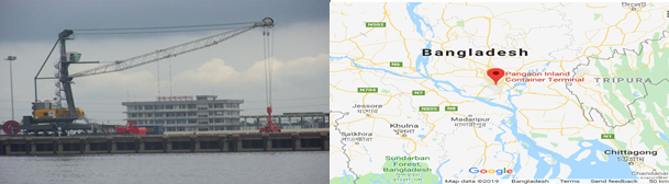
Facilities of the Port/Yard:
|
Storage capacity |
3,500 -20-foot equivalent units (TEUs) in its 55,000-sq mtr container yard |
|
Handling Capacity |
116,000 TEU annually |
|
CFS |
5815 Sq m |
|
Jetty |
The port has a 180-meter-long and 26-meter-wide jetty which can handle two ships of 70 to 75 meters at berth simultaneously |
|
Equipment |
v One mobile harbor crane v Two straddle carriers v Two tractor trailers v Three cargo-lifting cranes v Nine Forklifts v One Weigh Bridge |
When the port was opened, the chief shipping route was between Dhaka and Chattogram port. In February 2017, the first Indian ship from Kolkata docked at the port. In July 2017, China and Bangladesh signed an agreement to allow vessels to travel to the port. Coastal shipping agreements allow foreign vessels to directly carry cargo to Bangladeshi ports, instead of using Singapore or Colombo for transhipment.
Ashugonj ICT/ River Port
The Port of Ashuganj is a notable river port in eastern Bangladesh. It is one of the important industrial ports of the Bengal delta. It is located on the Meghna River. The port is a regional transhipment centre in Eastern South Asia. It is located 28 km from Brahmanbaria town and 43 km from the Akhaura land border between Bangladesh and India. The port is located in an industrial area in the vicinity of the Ashuganj Power Station, a 1777 megawatt thermal power plant which is one of the largest in Bangladesh. The port is also the terminal for a large fertilizer and chemical plant; as well as smaller power plants. It hosts several warehouses and shipyards. Its industrial units receive gas supplies from the nearby Titas Gas field.
Ashuganj port acts as a port of call for cargo shipments to the nearby Indian state of Tripura. Cargo unloaded in Ashuganj port is transported by road to the Akhaura-Agartala land border; and vice versa. The transhipment route allows access for several Indian states, including Mizoram, Manipur, Nagaland and Lower Assam.
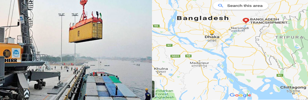
An International Container Terminal (ICT) is under-construction at Ashuganj Port with an estimated cost of BDT 12.93 billion. Out of the BDT 12.93 billion project cost, Bangladesh government will fund BDT 8.62 billion while the rest BDT 4.31 billion will come from the Indian 2nd Line of Credit (LoC). Bangladesh Inland Water Transport Authority (BIWTA) under the Ministry of Shipping will implement the project December 2021. If the project is implemented the new horizon will start in the shipping container transport through the river. It will be beneficial to Bangladesh financially and commercially.
This port provides the facility of loading and unloading of goods of the river vessels. According to the initial survey, it will be possible to transport around 0.4 million twenty feet equivalent units (TEUs) of containers on this route every year.
Summit Alliance Port Ltd
To support the Off-dock facilities of the govt Private entrepreneurs have also been asked to come forward. Attending that call of the govt Summit Group has developed a river port/Container yard named Summit Alliance Port Ltd. SAPL has established an Inland Container Terminal (ICT), the first of its kind in the country’s private sector, on 15 acres of Company’s freehold land on the bank of river Dhaleshwari in Muktarpur under Munshiganj district. The Inland Container Depot comprising transportation and storage of empty containers and redelivery of the containers to various locations as per client’s advice.
The River Terminal, being similar in certain respects to the Off-Dock establishment, shall have the bonded warehouse facilities with required handling equipment for Container Freight Station to handle export and import cargos as well as for storage of empty containers. In addition, the company provides container vessels for transportation of cargo to and from Chattogram Port. At Chattogram the company has three separate bonded depots on approx. 44 acre freehold land in Patenga, located 6.50 km away from the multipurpose container vessel berths of Chattogram Port, with facilities to provide both ICD and CFS services as detailed below:
- Total covered space of 511,000 sft including 7,020 sft for specialized Garments on Hanger (GOH), with 11 separate Warehouse spread over our three depots for storage of export cargo before stuffing and transportation of the same after completing Customs and other formalities.
- Import Warehouse of 19,500sft to handle import cargo
- Jute Warehouse measuring 8,430 sft
- ICD facility for storage of approx. 6,000 empty containers (at any point of time) with developed yard area of over 1.50 million sft.
- Plug-points for simultaneously handling 100 Refrigerated (Reefer) containers
- Fleet of heavy and light equipment’s including, amongst others, Laden Reach Stackers, Cranes, High & Low Mast Forklifts of various capacities, Empty Reach Stackers, Side Stackers Cargo Lifts, Trailers, Prime Movers and other handling equipment’s like hand-trolleys etc.
- Three Standby generators of 550 KVA, 320 KVA and 220 KVA capacities for supplying power to the entire yard and warehouses.
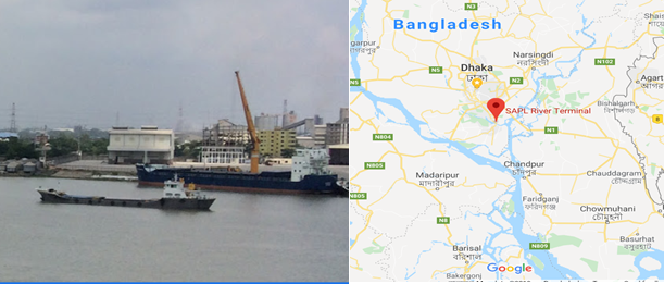
The company has received the Global Security Verification (GSV) certification which is the leading international business network for supporting the development and implementation of measures for enhancing global supply chain security. With this GSV certificate the company was determined by an independent 3rd party expert as having the appropriate security measures in place, as published by the U.S. Bureau of Customs and Border Protection. SAPL enjoys an esteemed clientele list including, among others, DAMCO, Kuehne+Nagel Ltd, APL Bangladesh Ltd, DSV Air & Sea Ltd, Maersk Bangladesh Ltd and several other prestigious Freight Forwarders and Mainline Operators.
International Waterways
As Bangladesh shares border mostly with India and it has good understanding with the govt of India, the two countries have common interests over waterways. In order to improve/increase the trade and tourism of both the countries, the govts have signed a Protocol on 6th June 2015 to facilitate the use of International waterways. The protocol initially outlined the following 8 Routes to be used by the operators of both the countries:
- Kolkata- Haldia- Raimongal- -Chalna- Khulna- Mongla- KawkhaliBarisal- Hizla- Chandpur- Narayanganj- Aricha- Sirajganj- BahadurabadChilmari- Dhubri- Pandu- Shilghat.
- Shilghat- Pandu- Dhubri- Chilmari- Bahadurabad- Sirajganj- ArichaNarayanganj- Chandpur- Hizla- Barisal- Kawkhali- Mongla- KhulnaChalna- Raimongal- Haldia- Kolkata.
- Kolkata- Haldia- Raimongal- Mongla- Kawkhali- Barisal- HizlaChandpur- Narayanganj- Bhairab Bazar- Ashuganj- Ajmiriganj- MarkuliSherpur- Fenchuganj- Zakiganj- Karimganj.
- Karimganj- Zakiganj- Fenchuganj- Sherpur- Markuli- AjmiriganjAshuganj- Bhairab Bazar- Narayanganj- Chandpur- Hizla- BansalKawkhali- Mongla- Raimongal- Haldia- Kolkata.
- Rajshahi- Godagari- Dhulian.
- Dhulian- Godagari- Rajshahi.
- Karimganj- Zakiganj- Fenchuganj- Sherpur- Markuli- AjmiriganjAshuganj- Bhairab Bazar- Narayanganj- Chandpur- Aricha- SirajganjBahadurabad- Chilmari- Dhubri- Pandu- Shilghat.
- Shilghat- Pandu- Dhubri- Chilmari- Bahadurabad- Sirajganj- ArichaChandpur- Narayanganj- Bhairab Bazar- Ashuganj- Ajmiriganj- MarkuliSherpur- Fenchuganj- Zakiganj- Karimganj
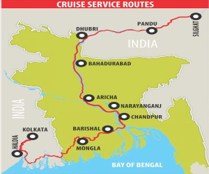
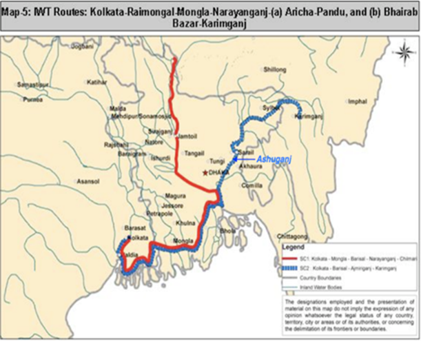
For now, cruise operators have shown interest to use Kolkata-Haldia-Raimongal-Chalna-Khulna-Mongla-Kawkhali-Barishal-Hizla-Chandpur-Narayanganj-Aricha-Sirajganj-Bahadurabad-Chilmari-Dhubri-Pandu-Shilghat (Assam) route, stretching 1,535km. In future such other routes will be declared by the Competent Authorities from time to time.
Water is essential to life and good Heath. It’s also vital to create jobs, propel economies forward, and boost social development. India and Bangladesh are reviving centuries-old inland waterways that once moved goods and people throughout both countries as well as into Bhutan and Nepal. The improvements will promote trade, attract investment, and stimulate development. More than 600 million people in Bangladesh and India live along the Ganges, Brahmaputra, and Meghna rivers. Millions more live near navigable tributaries. Moving goods via water is cheaper and more environmentally friendly than trucks on congested highways .
It may be mentioned here that for using waterways with other countries the waters of Bay of Bengal will be required to use.
General overview
Indian transit traffic and Indo-Bangladesh bilateral traffic regularly travel along two designated Inland Water Transport (IWT) Protocol routes across Bangladesh. These routes are highly underutilized, partly due to rapid siltation, lack of sufficient navigational aids, and partly due to Ltd number of ports of call (4 ports on either side). There are no inter-country passengers’ movements by IWT.
Initiative to move containers between Bangladesh and India, by IWT (inland water transport) is already underway, as it could also benefit Bangladesh considerably. An IWT container terminal is already in operation at Pangaon near Dhaka, with a design capacity of handling 116,000, 20 feet containers. This river port has encouraged containers movements between Kolkata-Dhaka, and Chattogram-Dhaka without difficulty.
Meanwhile Bangladesh ha s declared River port cum Container terminal at “Ashuganj” as the 5th port of call, while India agreed to designate “Shilghat” (near Guwahati and 100 km upstream of Pandu) as their 5th port of call for use by Bangladesh.
For additional details, please see the following document:
Bangladesh Waterways additional information
Note: The information provided in the attached documents, which has been taken from the old DLCA, does not match the structure of the new LCA and is therefore provided separately.
For contact information, please see the following link:
2.6 Bangladesh Storage Assessment
Introduction and overview
Despite strong economic growth and a steady decline in poverty in Bangladesh over the past decade, natural disasters regularly cause serious damage to the country’s infrastructure and agricultural sectors, severely affecting food access and food availability for the poor and vulnerable. As 80 percent of Bangladesh’s population lives in rural areas and around 53 percent of the rural population is classified as poor, climate shocks and stresses have particularly negative implications for their food, livelihood security and welfare. In Bangladesh a total 36 million MT of rice and around 2.6 million MT of wheat are produced in a year. More over some times during crisis more food grains are also imported to meet emergency situations. For safely storing the food grains, proper food storage capacity needs to be increased, for which the govt is working. At present, the total storage capacity of government warehouses and silos is around 2.1 million MT and this capacity will be increased to 2.7 million MT by 2020 and around 3 million MT by 2025. Moreover there are some private warehouses for storage on rental basis.
Government institutions on food and storage
The public food operation of Bangladesh is based on a set of policies and an organizational structure designed to carry out these policies. The Director General of Food (DGF) under the ministry of food is the primary organization consists of a number of branches entrusted with the task of procurement, storage, movement and distribution of food.
As a price stabiliser Public Food Distribution System (PFDS) acts as a buffer stock agency, buying paddy, rice and wheat when prices are low and later supplying that food grain to the market when prices are high. The GoB uses their PFDS network to transport the grain from the Silo or central storage deports (CSDs) to the local supply deports (LSDs). As per UNDAF, WFP also using these GoB’s PFDS system for managemet of their cereal food commodities. The lack of storage capacity in areas prone to natural disasters may result in delayed response to relief distribution. Improved processing system can produce higher output and reduce the storage, transit and handling losses as well as reduce post-harvest losses.
Storage plays the key role in the entire process of procurement. Under given situations of price and supplies, the level of procurement is functionally related to that of the storage facilities. Disparities between capacity utilisation at CSD and LSDs stem from the high demand for local transport. Capacity utilization and stock turnover vary considerably from season to season as warehouses are more fully and often over utilized during the height of the domestic procurement drive but remain relatively underutilized the rest of the year, taking them available to relief agencies.
List of Officers at the office of DG Food who are responsible for Management and operation of country's overall food system, Implementation of national food policy strategies and Establishment of dependable national food security system in the country along with meeting the emergency food requirement.
|
Name |
Designation |
Contact No |
|
|
|---|---|---|---|---|
|
Mr. Sarwar Mahmud |
Director General (Additional Secretary) |
Phone: +88-02-9584834 Fax: +88-02-9556067 |
||
|
Mr. Md. Harun-Ar-Rashid |
Personal Secretary to DG |
Phone: +88-02-9556064 |
||
|
Mr. Md. Abdul Aziz Molla |
Additional Director General |
Phone: +88-02-9561871 Mobile: 01937-087098 |
||
|
Mr. Parimal Chandra Sarker |
Director (Admin) |
Mobile: 01715-057088 |
||
|
Mr. Mohammad Faruk Hossain |
Additional Director |
Phone: +88-02-9583899 Mobile: 01921177554 |
||
|
Mr. Anisuzzzaman |
Director (Procurement) |
Phone: +88-02-9550261 Mobile: 01715122721 |
||
|
Mr. Md. Abdus Salam |
Addl. Director (Procurement) |
Phone: +88-02-9556302 Mobile: 01711-374674 |
||
|
Mr. Saiful Kabir Khan |
Deputy Director (EP) |
Phone: +88-02-9558166 Mobile: 01914-218205 |
||
|
Alamgir Kabir |
Deputy Director (IP) Procurement |
Phone: +88-02-9556197 Mobile: 01712-110889 |
||
|
Mr. Abdullah Al Mamun |
Director (Mov, Storage and Silo Division) |
Phone: +88-02-9550276 Mobile: 01713-202100 |
||
|
Mr. Utpal Kumar Shaha |
Addl. Director (Mov Storage & Silo) |
Phone: +88-02-9550270 Mobile: 01711-483894 |
||
|
Mr. Md. Selimul Azam |
Deputy Director (Mov, Storage and Silo Division) |
Phone: +88-02-9550270 Mobile: 01711-191815 |
|
|
|
Mr. Md. Nazim Uddin |
Deputy Director (Mov, Storage and Silo Division) |
Phone: 88-02-47120082 Mobile: 01718-064266 |
||
|
Mr. Amjad Hossain |
Director, Supply Distribution and Marketing (SDM) |
Phone: 88-02-9556075 Mobile: 01718957839 |
||
|
Mr. Harun Ur Rashid |
Deputy Director, SDM |
Phone: 88-02-9556075 Mobile: 01734718817 |
||
Regional and district controller of food
|
Dhaka Region |
|||
|---|---|---|---|
|
Sl. No |
Name & Designation |
Office Phone |
|
|
1. |
Mr. Md. Jamal Hossain, RCF, Dhaka |
02-7452983 |
|
|
2. |
Mr. Md. Main Uddin DCF, Dhaka |
02-7452914 |
|
|
3. |
Mr. Md. Sirajul Islam DCF, Narayangonj |
02-7634652 |
|
|
4. |
Mr. Md. Jahangir Alam (A.C.) DCF, Narshindi |
02-9462614 |
|
|
5. |
Mr. Md. Abu Bakar (In Charge) DCF, Munshigonj |
0691-7611130 |
|
|
6. |
Mr. Md. Zahirul Islam Khan DCF, Gazipur |
02-9262439 |
|
|
7. |
Mr. Md. Kamal Hossain DCF, Manikgonj |
0651-7710399 |
|
|
8. |
Mr. Md. Jahangir Alam DCF, Mymensing |
091-64359 |
|
|
9. |
Mr. Ms. Suraya Khatun DCF, Netrokona |
0951-61470 |
|
|
10. |
Mr. Md. Mahabubur Rahman Khan DCF, Jamalpur |
0981-63124 |
|
|
11. |
Mr. Md. Forhath Khandokar DCF, Sherpur |
0931-61348 |
|
|
12. |
Mr. Md. Kamal Hossain DCF, Tangail |
0921-64018 |
|
|
13. |
Mr. Mojibur Rahman DCF, Rajbari |
0641-65535 |
|
|
14. |
Mr. Md. Tazul Islam (self-pay) DCF, Faridpur |
0631-63096 |
|
|
15. |
Mr. Saifur Rahman (A. C.) DCF, Gopalgonj |
0668-55370 |
|
|
16. |
Mr. Saifur Rahman DCF, Madaripur |
0661-62317 |
|
|
17. |
Mr. Nur E Alam Siddiqiue DCF, Shariatpur |
0601-61636 |
|
|
18. |
Mr. Mohammad Tanvir Hossain DCF, Kishorgonj |
0941-61788 |
|
|
Barisal Region |
|||
|
1. |
Mr. Reza Mohammad Mohsin RCF, Barishal |
0431-61012 0431-61013 |
|
|
2. |
Mr. Md. Moshiur Rahman DCF, Barishal |
0431-2175403 |
|
|
3. |
Mr. Md. Nazmul Hossain DCF, Jhalakati |
0498-63252 |
|
|
4. |
Mr. Moklech AL Amin DCF, Patuakhali |
0441-62414 |
|
|
5. |
Mr. Sonchit Chakma DCF, Perojpur |
0461-62519 |
|
|
6. |
Mr. Md. Shahidul Islam DCF, Borguna |
0448-62309 |
|
|
Chattogram Region |
|||
|
1. |
Mr. Md. Jamal Hossain, RCF, Chattogram |
031-613112, 031-637053 |
|
|
2. |
Mr. Abu Nayeem Md. Shafiul Alam DCF, Chattogram |
031-637219 |
|
|
3. |
Mr. S M Tahsinul Hoq (c.c) DCF, Coxs bazaar |
0341-63311 0341-64255 |
|
|
4. |
Mr. SUMAYIA NAJNIN (c.c.) DCF, Rangamati |
0351-62331 |
|
|
5. |
Mr. Md. Ashraful Alam DCF, Khagrachari |
0371-61860 |
|
|
6. |
Mr. Noyon Joti Chakma (A.C.) DCF, Bandarban |
0361-62558 |
|
|
7. |
DCF, Noakhali |
0321-61057 |
|
|
8. |
Mr. Nayan Joti Chakma (Addl) DCF, Laxmipur |
0381-62566 |
|
|
9. |
Mr. S M Kaisar Ali (Addl) DCF, Feni |
0331-74025 |
|
|
10. |
Mr. S. M Kaisar Ali DCF, Cumilla |
081-64655 |
|
|
11. |
Mr. Subir Nath Chowdhury DCF, Brahmonbaria |
0851-58232 |
|
|
12. |
Mr. Subhash Chandra Nam (AC) DCF, Chandpur |
0841-63160 |
|
|
Khulna Region |
|||
|
1. |
Mr. Md. Mahabubur Rahman RCF, Khulna |
041-762398 |
|
|
2. |
Mr. Muhammad Tanvir Rahman DCF, Khulna |
041-2830084 |
|
|
3. |
Mr. A K M Shahidul Haque (Acting) DCF, Bagerhat |
0468-62257 |
|
|
4. |
Mr. Md. Zakir Hossain DCF, SaBDThira |
0471-63219 |
|
|
5. |
Mr. Manwar Hossain (In Charge) DCF, Kushtia |
071-61918 |
|
|
6. |
Mr. Md. Razaul Karim (In Charge) DCF, Chuadanga |
0761-63150 |
|
|
7. |
Mr. Md. Abdul Hamin Biswash DCF, Meherpur |
0791-62320 |
|
|
8. |
Mr. Md Liakot Hossain DCF, Jashore |
0421-65122 |
|
|
9. |
Mr. Nakib Sad Saiful Islam DCF, Jhenaidah |
0451-63209 |
|
|
10. |
Mr. Md. Main-Ul-Islam (Incharge) DCF, Magura |
0488-62411 |
|
|
11. |
Mr. Monotosh Kunar Mojumdar (Acting) DCF, Narail |
0481-62316 |
|
|
Rajshahi Region |
|||
|
1. |
Mr. Md. Moniruzzaman RCF, Rajshahi |
0721-772656 0721-776340 |
|
|
2. |
Mr. Md Nazmul Haque Bhuiyan DCF, Rajshahi |
0721-774821 |
|
|
3. |
Mr. G. M. Faruk Hossain Patwary DCF, Noagaon |
0741-62485 |
|
|
4. |
Mr. Md Shafiqul Islam DCF, Natore |
0771-62608 |
|
|
5. |
Mr. Md. Reajur Rahman Raju DCF, Chapainawabganj |
0781-52473 |
|
|
6. |
Mr. Iqbal Bahar Chowdhury DCF, Pabna |
0731-66135 |
|
|
7. |
Mr. Md. Mizanur Rahman DCF, Sirajganj |
0751-62178 |
|
|
8. |
Mr. Md. Monirul Islam DCF, Joypurhat |
0571-62367 |
|
|
9. |
Mr. S M Saiful Islam DCF, Bogura |
051-66015 |
|
|
Rangpur Region |
|||
|
1. |
Mr. Md. Raihanul Kabir RCF, Rangpur |
0521-52140 |
|
|
2. |
Mr. Md. Abdul Kader DCF, Rangpur |
0521-62282 |
|
|
3. |
Mr. Md. Zahirul Islam DCF, Gaibanda |
0541-61593 |
Website: http://food.gaibandha.gov.bd/ |
|
4. |
Mr. Kazi Saifuddin (A.R) DCF, Lalmonirhat |
0591-61406 |
Website: http://food.lalmonirhat.gov.bd/ |
|
5. |
Mr. Md. Mohibul Hoq DCF, Kurigram |
0581-61453 |
Website: http://food.kurigram.gov.bd/ |
|
6. |
Mr. Kazi Saifuddin DCF, Nilphamari |
0551-61448 |
Website: http://food.nilphamari.gov.bd/ |
|
7. |
Mr. Md. Ashrafuzzaman DCF, Dinajpur |
0531-65066 |
Website: http://food.dinajpur.gov.bd/ |
|
8. |
Mr. Mohammad. Babul Hossain DCF, Thakurgaon |
0561-52030 |
Website: http://food.thakurgaon.gov.bd/ |
|
9. |
Mr. Mohammad Babul Hossain (Addl) DCF, Panchgor |
0568-61311 |
Website: http://food.panchagarh.gov.bd/ |
|
Sylhet Region |
|||
|
1. |
Mr. Mohammad Mamunur Rashid RCF, Sylhet |
0821-840836 |
|
|
2. |
Mr. Md Mizanur Rahman DCF, Sylhet |
0821-717143 |
|
|
3. |
Mr. Manoj Kanti Das Chowdhury DCF, Moulvibazar |
0861-52210 |
|
|
4. |
Mr. Md. Abdus Salam (CC) DCF, Hobigonj |
0831-62322 |
|
|
5. |
Mr. Md. Zakaria Mostafa (CC) DCF, Sunamgonj |
0871-61590 |
|
Officers' information (Silos)
| Ashugonj | |||
|---|---|---|---|
|
Sl. No |
Name & Designation |
Office Phone |
|
|
1. |
Mr. Mohammad Anwar Hossain Silo Superintendent, Ashugonj |
08528-74202, Fax: 08528-74499 |
|
|
2. |
Mr. Khondakar Serajus Saleqin Maintenance Engineer |
08528-74203, Fax: 08528-74499 |
|
|
Chattogram |
|||
|
1. |
Mr. Mohammad Asaduzzaman Silo Superintendent, Chattogram |
031-2501252 Fax: 031-2501255 |
|
|
2. |
Mohammad Ashfaqur Rahman Assistant Maintenance Engineer |
031-2501253 |
|
|
Narayangonj |
|||
|
1. |
Mr. Md. Tajol Islam Silo Superintendent, Narayangonj |
02-7693140 Fax: 02-7694175 |
|
|
2. |
Rakibul Hasan Maintenance Engineer |
02-7693012 |
|
|
Shantahar, Bogura |
|||
|
1. |
Mr. Mohammad Faizullah Khan Shiblee Silo Superintendent, Santahar |
0741-69483 |
|
|
Khulna and Mongla |
|||
|
1. |
Mr. Arup Kumar Mishra Silo Superintendent (Khulna) (Addl Charge-Mongla) |
041-774528 |
silo.kln@dgfood.gov. (Khulna) silo.mongla@dgfood.gov.bd (Mongla) |
Various storage types
Following types of storage system are now prevailing in the country:
- Homestead storage.
- Trade level storage.
- Mill cum trade level storage.
- Automatic milling storage.
- Government storage for buffer stock.
- Modern storage system.
While storage facilities and functions assume great importance, particularly in the case of subsistence crop, little is known about the various aspects of the initial storage of rice and paddy. The big rice-millers have large storage godowns in their compounds. They perform a considerable part of this function in the area they are located. The traders at the primary market do not have any storage facilities.
BADC warehouse and cold storage with capacity
|
Sl |
District /Place |
Storage area (sq ft) |
Capacity (MT) |
Remarks |
|---|---|---|---|---|
|
Cold Storage for Fish, Fruit and Vegetables |
||||
|
1. |
Dhaka Airport |
- |
120 |
|
|
2. |
Jhumjhumpur, Jashore |
- |
50 |
|
|
3. |
Sholoshohor, Chattogram |
- |
50 |
|
|
4. |
Sayedpur, Cumilla |
- |
50 |
|
|
5. |
Chitla, Meherpur |
3500 |
50 |
Dehumidified |
|
6. |
Monirampur, Jashore |
3500 |
70 |
Dehumidified |
|
7. |
Nashipur, Dinajpur |
2500 |
100 |
Dehumidified |
|
8. |
Kashimpur, Gajipur |
13520 |
1000 |
|
|
9. |
Sherpur |
11224 |
1000 |
|
|
10. |
Kishorganj |
11520 |
1000 |
|
|
11. |
Shrimongol, Moulovi Bazar |
8405 |
1000 |
|
|
12. |
Bogura |
6400 |
1000 |
|
|
13. |
Faridpur |
9600 |
1000 |
|
|
14. |
Jashore |
9600 |
1000 |
|
|
15. |
Rangpur |
12800 |
1000 |
|
|
16. |
Rajshahi |
10310 |
1000 |
|
|
17. |
Thakurgaon |
10800 |
1000 |
|
|
18. |
Baradi, Meherpur |
9600 |
1000 |
|
|
19. |
Noshipur, Dinajpur |
9600 |
1000 |
|
|
20. |
Chandpur |
8595 |
1000 |
|
|
21. |
Kushtia |
12000 |
1200 |
|
|
22. |
Dhonbari, Tangail |
20000 |
6000 |
|
|
23. |
Domar, Nilfamari |
9400 |
1500 |
|
|
24. |
Homna, Cumilla |
9600 |
1000 |
|
|
25. |
Gopalgonj |
580 |
50 |
Dehumidified |
|
26. |
Naogaon |
775 |
40 |
Dehumidified |
|
General Storage/Warehouse |
||||
|
27. |
Citla,Meherpur |
8600 |
340 |
|
|
28. |
Nashipur, Dinajpur |
8250 |
300 |
|
|
29. |
Bogura, Rajshahi |
6950 |
400 |
|
|
30. |
Chuadanga |
58400 |
7300 |
|
|
31. |
Tangail |
66,487.5 |
7,950 |
|
|
32. |
Rangpur |
40,000 |
5000 |
|
|
33. |
Dinajpur |
38400 |
4800 |
|
|
34. |
Faridpur |
39200 |
4900 |
|
|
35. |
Chattogram |
18,779 |
2350 |
|
|
36. |
Cumilla |
36,900 |
4,200 |
|
|
37. |
Pabna |
36,000 |
4,500 |
|
|
38. |
Thakurgaon |
38,400 |
4,800 |
|
|
39. |
Jashore |
30,400 |
3,800 |
|
|
40. |
Bogura |
30,400 |
3800 |
|
|
41. |
Meherpur |
14,800 |
1,850 |
|
|
42. |
Rajshahi |
29,600 |
3,700 |
|
|
43. |
Dhaka |
43,131 |
4,880 |
|
|
44. |
Hobiganj |
14,400 |
1,800 |
|
|
45. |
Barisal |
6,400 |
800 |
|
|
46. |
Narayanganj |
268.75 |
25 |
|
|
47. |
Norsingdi |
537.5 |
50 |
|
|
48. |
Shripur |
537.5 |
50 |
|
|
49. |
Kaliganj |
215 |
20 |
|
|
50. |
Gajipur |
537.5 |
50 |
|
|
51. |
Manikganj |
1612.5 |
150 |
|
|
52. |
Munsiganj |
3225 |
300 |
|
|
53. |
Mymensingh |
11,825 |
1,100 |
|
|
54. |
Muktagacha |
2,150 |
200 |
|
|
55. |
Goforgaon |
537.5 |
50 |
|
|
56. |
Isshorganj |
537.5 |
50 |
|
|
57. |
Nandail |
4300 |
400 |
|
|
58. |
Fulpur |
4300 |
400 |
|
|
59. |
Jamalpur |
5375 |
500 |
|
|
60. |
Melandoho |
537.5 |
50 |
|
|
61. |
Sherpur |
2,150 |
200 |
|
|
62. |
Kishorganj |
5,590 |
520 |
|
|
63. |
Pakundia |
1,075 |
100 |
|
|
64. |
Netrokona |
1,612.5 |
150 |
|
|
65. |
Faridpur |
13,625 |
1,250 |
|
|
66. |
Madaripur |
1,612.5 |
150 |
|
|
67. |
Shoriyatpur |
1,612.5 |
150 |
|
|
68. |
Rajbari |
537.5 |
50 |
|
|
69. |
Gopalganj |
537.5 |
50 |
|
|
70. |
Cox’s Bazar |
4,300 |
400 |
|
|
71. |
Rangamati |
1,075 |
100 |
|
|
72. |
Bandorban |
1,075 |
100 |
|
|
73. |
Thanchi |
215 |
20 |
|
|
74. |
Lama |
215 |
20 |
|
|
75. |
Khagrachori |
2,150 |
200 |
|
|
76. |
Noakhali |
12,900 |
1,200 |
|
|
77. |
Lakshmipur |
537.5 |
50 |
|
|
78. |
Feni |
2,150 |
200 |
|
|
79. |
Debidwar |
2,150 |
200 |
|
|
80. |
Borura |
2,150 |
200 |
|
|
81. |
Daudkandi |
4,300 |
400 |
|
|
82. |
Burichong |
215 |
20 |
|
|
83. |
Laksam |
4,300 |
400 |
|
|
84. |
Chouddogram |
4,300 |
400 |
|
|
85. |
B. Baria |
5,750 |
530 |
|
|
86. |
Hajiganj |
430 |
40 |
|
|
87. |
Chandpur |
5,375 |
500 |
|
|
88. |
Sylhet |
11,825 |
1,400 |
|
|
89. |
Moulovibazar |
2,150 |
200 |
|
|
90. |
Hobiganj |
537.5 |
50 |
|
|
91. |
Sunamganj |
537.5 |
50 |
|
|
92. |
Rajshahi |
10,750 |
1,000 |
|
|
93. |
Boraigram |
2,150 |
200 |
|
|
94. |
Chapai Nobabganj |
537.5 |
50 |
|
|
95. |
Nowga |
4,300 |
400 |
|
|
96. |
Natore |
2,150 |
200 |
|
|
97. |
Pabna |
7,525 |
700 |
|
|
98. |
Sirajganj |
5,375 |
500 |
|
|
99. |
Bogura |
7,632.4 |
710 |
|
|
100. |
Joypurhat |
2,150 |
200 |
|
|
101. |
Rangpur |
15,050 |
1,400 |
|
|
102. |
Pirganj |
1,075 |
100 |
|
|
103. |
Polashbari |
3,225 |
300 |
|
|
104. |
Gobindoganj |
3,225 |
300 |
|
|
105. |
Pirgacha |
2,150 |
200 |
|
|
106. |
Sayedpur |
215 |
20 |
|
|
107. |
Nilfamari |
1,075 |
100 |
|
|
108. |
Gaibandha |
1,075 |
100 |
|
|
109. |
Ulipur |
2,150 |
200 |
|
|
110. |
Nageshwari |
752.5 |
70 |
|
|
111. |
Kurigram |
2,150 |
200 |
|
|
112. |
Lalmonirhat |
1,290 |
120 |
|
|
113. |
Dinajpur |
1,075 |
100 |
|
|
114. |
Parbotipur |
1,075 |
100 |
|
|
115. |
Birganj |
2,150 |
200 |
|
|
116. |
Thakurgaon |
3,225 |
300 |
|
|
117. |
Ponchogar |
2,150 |
200 |
|
|
118. |
Khulna |
9,137.5 |
850 |
|
|
119. |
Bagerhat |
537.5 |
50 |
|
|
120. |
Kaliganj |
2,150 |
200 |
|
|
121. |
SaBDThira |
537.5 |
50 |
|
|
122. |
Jashore |
19,550 |
2000 |
|
|
123. |
Keshabpur |
2,150 |
200 |
|
|
124. |
Moheshpur |
537.5 |
50 |
|
|
125. |
Jhinaidah |
1,290 |
120 |
|
|
126. |
Shripur |
215 |
20 |
|
|
127. |
Magura |
1,612.5 |
150 |
|
|
128. |
Norail |
537.5 |
50 |
|
|
129. |
Kushtia |
6,450 |
600 |
|
|
130. |
Meherpur |
537.5 |
50 |
|
|
131. |
Damurhuda |
537.5 |
50 |
|
|
132. |
Jibon Nogor |
537.5 |
50 |
|
|
133. |
Chuadanga |
1,612.5 |
150 |
|
|
134. |
Barisal |
12,900 |
1,200 |
|
|
135. |
Pirojpur |
161.25 |
15 |
|
|
136. |
Bhola |
3,225 |
300 |
|
|
137. |
Potuakhali |
4,300 |
400 |
|
|
138. |
Borguna |
215 |
20 |
|
|
139. |
Mothura |
- |
500 |
|
|
140. |
Gokulnagar |
- |
650 |
|
|
141. |
Korincha |
- |
625 |
|
|
142. |
Kushadanga |
- |
750 |
|
|
143. |
Sadhuhati |
- |
515 |
|
|
144. |
Pathila |
- |
600 |
|
|
145. |
Nurnagar |
- |
100 |
|
|
146. |
Tebunia |
- |
700 |
|
|
147. |
Meherpur |
- |
700 |
|
|
148. |
Modhupur |
- |
700 |
|
|
149. |
Kashimpur |
- |
1100 |
|
|
150. |
Netrokona |
- |
200 |
|
|
151. |
Pangsha |
- |
175 |
|
|
152. |
Tambulkhana |
- |
300 |
|
|
153. |
Lakutia |
- |
100 |
|
|
154. |
Panchgachiya |
- |
150 |
|
|
155. |
Itakhola |
- |
200 |
|
|
156. |
Jhilongja |
- |
300 |
|
|
157. |
Thakurgaon |
- |
195 |
|
|
158. |
Nilphamari |
- |
300 |
|
|
159. |
Boalia |
- |
50 |
|
|
160. |
Modhupur, Tangail |
7749 |
950 |
|
|
161. |
Jamalpur |
8896 |
775 |
|
|
162. |
Chuadanga |
32258 |
3000 |
|
|
163. |
Meherpur |
2689 |
250 |
|
|
164. |
Jashore |
13119 |
1400 |
|
|
165. |
Tebunia, Pabna |
1499 |
100 |
|
|
166. |
Rajshahi |
5220 |
400 |
|
|
167. |
Bogura |
3226 |
300 |
|
|
168. |
Rangpur |
1764 |
700 |
|
|
169. |
Dinajpur |
54226 |
200 |
|
|
170. |
Thakurgaon |
9753 |
850 |
|
|
171. |
Mymensingh |
29025 |
2700 |
|
|
172. |
Chuadanga |
51278 |
4770 |
|
|
173. |
Rangpur |
30638 |
2750 |
|
|
174. |
Bogura |
25370 |
2360 |
|
|
175. |
Feni |
27681 |
2575 |
|
|
176. |
Sylhet |
23435 |
2180 |
|
|
177. |
SaBDThira |
21178 |
1970 |
|
|
178. |
Thakurgaon |
35475 |
3300 |
|
|
179. |
Gajipur |
33863 |
3150 |
|
|
180. |
Jamalpur |
36013 |
3350 |
|
|
181. |
Kishorganj |
27950 |
2600 |
|
|
182. |
Netrokona |
31175 |
2900 |
|
|
183. |
Nokla, Sherpur |
4312 |
200 |
|
|
184. |
Gopalgonj |
4110 |
950 |
|
|
185. |
Ramu, Cox’s Bazar |
3932 |
350 |
|
|
186. |
Naoga |
1925 |
120 |
|
|
187. |
Potuakhali |
525 |
50 |
|
|
188. |
Bhola |
4100 |
200 |
|
|
189. |
Kulaura, Moulovi Bazar |
1350 |
100 |
|
|
190. |
Modhupur, Tangail |
10580 |
1000 |
|
|
191. |
Tangail |
10580 |
1000 |
|
|
192. |
Kishorganj |
10580 |
1000 |
|
|
193. |
Gabtoli, Dhaka |
5057 |
107 |
|
|
194. |
Amjhupi, Meherpur |
2000 |
30 |
|
|
195. |
Alamnagar, Rangpur |
3771 |
45 |
|
Storage capacity of public sector
Storage facilities in Govt CSDs, LSDs and Silos
Bangladesh has adequate storage facilities all across the country for storing various types of food grains. These warehouses have huge storage spaces which are often underutilized during any given month or season of the year. But some of them are old which needs to be renovated.
For storage of food grains, there are total 654 storage facilities of different types (LSD-635, CSD-12, Silo-6 and 1 Multi-purpose Warehouse) with a total capacity of approximate 21,00,000 MT of rice and. These warehouses have good facilities in terms of equipment, skilled labour, stacking facilities, fumigation capacities at affordable prices, ventilation, augmented storage facilities, parking, security. In addition, 8 more Modern Silos and 158 LSDs with a total capacity of 6,40,000 MT are being constructed which is expected to be completed by 2020. The present district wise Food grain Storage Capacity (MT) at various LSDs, CDSs and Silos are shown below:
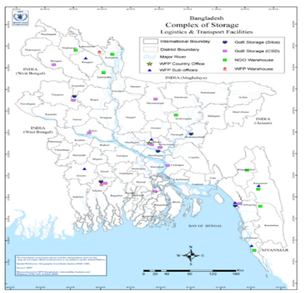
District wise Food grain Storage Capacity (MT)
|
District |
LSD |
CSD |
Silo |
All Types |
District |
LSD |
CSD |
Silo |
All Types |
||||||||||
|---|---|---|---|---|---|---|---|---|---|---|---|---|---|---|---|---|---|---|---|
|
No |
Capacity |
No |
Capacity |
No |
Capacity |
No |
Capacity |
No. |
Capacity |
No. |
Capacity |
No. |
Capacity |
No. |
Capacity |
||||
|
Dinajpur |
25 |
66500 |
1 |
20500 |
|
|
26 |
87000 |
Mymensingh |
19 |
36500 |
1 |
30000 |
|
|
20 |
66500 |
||
|
Thakurgaon |
12 |
43250 |
|
|
|
|
12 |
43250 |
Jamalpur |
8 |
17300 |
|
8 |
17300 |
|||||
|
Panchagarh |
8 |
22500 |
|
|
|
|
8 |
22500 |
Netrokona |
14 |
19000 |
|
|
|
|
14 |
19000 |
||
|
Rangpur |
9 |
20000 |
|
|
|
|
9 |
20000 |
Sherpur |
5 |
20000 |
|
|
|
|
5 |
20000 |
||
|
Lalmonirhat |
7 |
16500 |
|
|
|
|
7 |
16500 |
Mymensingh D |
46 |
92800 |
1 |
30000 |
|
|
47 |
122800 |
||
|
Kurigram |
9 |
25000 |
|
|
|
|
9 |
25000 |
Manikganj |
8 |
14000 |
|
|
|
|
8 |
14000 |
||
|
Gaibandha |
11 |
30250 |
|
|
|
|
11 |
30250 |
Dhaka |
5 |
6250 |
2 |
40500 |
|
|
7 |
46750 |
||
|
Nilphamari |
7 |
25000 |
|
|
|
7 |
25000 |
Narosingdi |
7 |
16250 |
|
|
|
|
7 |
16250 |
|||
|
Rangpur Div |
88 |
249000 |
1 |
20500 |
0 |
0 |
89 |
269500 |
Kishoreganj |
14 |
28750 |
|
|
|
|
14 |
28750 |
||
|
Bogura |
23 |
60000 |
1 |
54250 |
1 |
25000 |
23 |
139250 |
Narayanganj |
4 |
4300 |
1 |
11700 |
1 |
50000 |
6 |
66000 |
||
|
Joypurhat |
7 |
28100 |
|
|
|
|
7 |
28100 |
Munshiganj |
7 |
16430 |
|
|
|
|
7 |
16430 |
||
|
Rajshahi |
12 |
25850 |
|
|
|
|
12 |
25850 |
Tangail |
14 |
34618 |
|
|
|
|
14 |
34618 |
||
|
Natore |
7 |
10000 |
|
|
|
|
7 |
10000 |
Rajbari |
4 |
10500 |
|
|
|
|
4 |
10500 |
||
|
Noagaon |
19 |
39250 |
|
|
|
|
19 |
39250 |
Faridpur |
8 |
15500 |
|
|
|
|
8 |
15500 |
||
|
Nowabganj |
7 |
19500 |
|
|
|
|
7 |
19500 |
Gopalganj |
6 |
11500 |
|
|
|
|
6 |
11500 |
||
|
Pabna |
10 |
30000 |
1 |
52500 |
|
|
11 |
82500 |
Madaripur |
7 |
19000 |
|
|
|
|
7 |
19000 |
||
|
Sirajganj |
10 |
32500 |
|
|
|
10 |
32500 |
Shariatpur |
6 |
11000 |
|
|
|
6 |
11000 |
||||
|
Rajshahi Div |
95 |
245200 |
2 |
106750 |
1 |
25000 |
98 |
376950 |
Gazipur |
5 |
9000 |
|
|
|
|
5 |
9000 |
||
|
Khulna |
8 |
8000 |
2 |
136900 |
1 |
800 |
11 |
145700 |
Dhaka Div. |
95 |
197008 |
3 |
52200 |
1 |
50000 |
99 |
299208 |
||
|
Bagerhat |
9 |
16000 |
|
|
1 |
50000 |
10 |
66000 |
Cox's bazar |
10 |
22000 |
|
|
|
|
10 |
22000 |
||
|
SaBDThira |
11 |
17500 |
|
|
|
|
11 |
17500 |
Rangamati |
13 |
7000 |
|
|
|
|
13 |
7000 |
||
|
Kushtia |
8 |
15500 |
|
|
|
|
8 |
15500 |
Khagrachari |
11 |
8250 |
|
|
|
|
11 |
8250 |
||
|
Chuadanga |
5 |
15250 |
|
|
|
|
5 |
15250 |
Banderban |
8 |
5000 |
|
|
|
|
8 |
5000 |
||
|
Meherpur |
3 |
5000 |
|
|
|
|
3 |
5000 |
Noakhali |
11 |
23000 |
|
|
|
|
11 |
23000 |
||
|
Jashore |
10 |
19000 |
|
|
|
|
10 |
19000 |
Laxipur |
6 |
11500 |
|
|
|
|
6 |
11500 |
||
|
Jhenidah |
9 |
17500 |
|
|
|
|
9 |
17500 |
Feni |
6 |
12750 |
|
|
|
|
6 |
12750 |
||
|
Megura |
6 |
10000 |
|
|
|
|
6 |
10000 |
Cumilla |
17 |
39000 |
|
|
|
|
17 |
39000 |
||
|
Narail |
5 |
7500 |
|
|
|
5 |
7500 |
B. Baria |
10 |
17500 |
|
|
1 |
50000 |
10 |
67500 |
|||
|
Khulna Div. |
74 |
131250 |
2 |
136900 |
1 |
800 |
77 |
318950 |
Chandpur |
7 |
8000 |
1 |
7000 |
|
|
7 |
15000 |
||
|
Barisal |
10 |
15500 |
1 |
22780 |
|
|
11 |
38280 |
Chottagram |
16 |
22500 |
2 |
173624 |
1 |
100000 |
19 |
296124 |
||
|
Jhalakathi |
4 |
9125 |
|
|
|
|
4 |
9125 |
Chottagram Di |
115 |
176500 |
3 |
180624 |
2 |
150000 |
120 |
507124 |
||
|
Perojpur |
8 |
16000 |
|
|
|
|
8 |
16000 |
Moulvibazar |
10 |
11000 |
|
|
|
|
10 |
11000 |
||
|
Bhola |
7 |
15250 |
|
|
|
7 |
15250 |
Habiganj |
13 |
20250 |
|
|
|
|
13 |
20250 |
|||
|
Patuakhali |
8 |
17500 |
|
|
|
|
8 |
17500 |
Sunamganj |
14 |
21400 |
|
|
|
|
14 |
21400 |
||
|
Barguna |
6 |
13000 |
|
|
|
|
6 |
13000 |
Sylhet |
15 |
17050 |
|
|
|
|
15 |
17050 |
||
|
Barisal Div. |
43 |
86375 |
1 |
22780 |
0 |
0 |
44 |
109155 |
Sylhet Div. |
52 |
69700 |
0 |
0 |
0 |
0 |
52 |
69700 |
||
|
LSD- 635 Capacity- 1247833 |
CSD-12 Capacity-549754 |
Silo- 6 Capacity-275800 |
Multi- Warehouse-1 Capacity-50,000 |
Total Storage -654 Capacity-2,123,387 |
Storage and warehouse facilities of BADC
Bangladesh Agricultural Development Corporation (BADC) under the Agricultural Ministry has developed a huge warehouse network all over the country for preservation of food stuff specially frozen Fish, various Seed, Fruits and Vegetables. They use these warehouses for their own requirement at the same time rent them on commercial basis to different organizations when ever deemed suitable or to meet urgent requirements. For any requirement they can be contacted at :
|
Bangladesh Agricultural Development Corporation (BADC) |
Phone: PABX: 9556080-7 & Fax: 88-02-9564357 |
Modern Food Storage Facilities Project
Despite strong economic growth and a steady decline in poverty in Bangladesh over the past decade, natural disasters regularly cause serious damage to the country’s infrastructure and agricultural sectors, severely affecting food access and food availability for the poor and vulnerable. As 80 percent of Bangladesh’s population lives in rural areas and around 53 percent of the rural population is classified as poor, climate shocks and stresses have particularly negative implications for their food, livelihood security, and welfare.
Government has received an IDA credit toward the costs of the Modern Food Storage Facilities Project (MFSP), being implemented by the Directorate General of Food, Ministry of Food. The modern food storage facilities could considerably improve the efficacy of the government’s emergency response and recovery efforts in disaster-prone areas and could enhance the efficiency of its Public Food Distribution System. Modern storage facilities in different strategic locations across the country will allow grain to be kept in bulk for up to 2/3 years in better conditions relative to the godowns used currently, with reduced grain losses and enhanced nutritional value of the grain distributed. At least 10 million people (or some 25 percent of the population living in the project area) are expected to directly or indirectly benefit from the project, primarily vulnerable and poor people in areas regularly affected by floods and cyclones. About 500,000 households (around 2.5 million people) will directly benefit from facilitated access to household silos, half of which will be women and children.
With strengthened capacity for improving stock management in the modern silos, and comprehensive analyses for enhancing the overall policy framework on strategic grain reserves, GoB will be able to make sound and informed decisions as it reconciles the following 3 strategic objectives that impact the domestic food market:
- Supporting the poor and vulnerable through effective Social Safety Net programs
- Improving the country’s disaster preparedness to meet food security needs caused by disaster-induced food shortages
- Devising non-distortive market interventions for food price stabilization, mainly for coarse grain consumed by the poor and vulnerable.
Specific objectives of the project
The overall project development objective is to increase the grain reserve available to households to meet their post-disaster needs and improve the efficiency of grain storage management.
- Develop 8 Silo complex of capacity 5.36 lakh MT
- Facilitate households’ access to domestic silos to ensure household level food security (5 Lakh)
- Reduce storage losses
- Adopt the best suited technology for preservation of food grain quality, quantity and nutritional level
- Ensure safe storage of food grain during calamities
- Ensure Better monitoring and improved governance and management of food stocks.
Strategic sites for silo with capacity
|
Sl |
Site |
No. of Bins |
Bin Size (in feet) |
Bin capacity (MT) |
Silo capacity (MT) |
|---|---|---|---|---|---|
|
1 |
Barisal |
16 |
60 D X 40 H |
3,000 |
48,000 |
|
2 |
Narayanganj |
16 |
60 D X 40 H |
3,000 |
48,000 |
|
3 |
Dhaka |
16 |
60 D X 40 H |
3,000 |
48,000 |
|
4 |
Ashuganj |
35 |
60 D X 60 H |
3,000 |
105,000 |
|
5 |
Mymensingh |
16 |
60 D X 40 H |
3,000 |
48,000 |
|
6 |
Maheshwarpasha (Wheat) |
6 |
90 D X 78 H |
12,700 |
76,200 |
|
7 |
Chattogram (Wheat) |
9 |
90 D X 78 H |
12,700 |
114,300 |
|
8 |
Madhupur |
16 |
60 D X 40 H |
3,000 |
48,000 |
|
|
Total |
130 Bins |
|
|
535,500 MT |
Household silos
Under the 2007 Emergency Cyclone Recovery and Reconstruction Project (ECRRP, P111272), household-level silos or grain storage bins were developed in Bangladesh. These units are specially designed 70-liter, food-grade plastic bins tested to ensure that chemical contaminants do not migrate into the stored food. They hold about 40kg of paddy equipped with a watertight lid, preventing water intrusion from surges and floods. Provision of home storage units under ECRRP has been extremely successful; under FAO coordination some 20,000 units were distributed. Based on the lessons learned from the ECRRP, this project’s investment in small-scale storage at the rural household level is expected to bring important benefits to the farming community – in the form of safer storage of rice, seed and the enhanced capacity of affected households to have seed readily available for subsequent planting seasons.
Warehouse/storage facilities in private sector
Bangladesh is a significant exporter of readymade garments, frozen fish, vegetables and shrimps to different destinations of the world for which the private sector has developed a strong and efficient right-on-time logistics chain, including cold-chain. Hundreds of Shipping Agents, CC & FF companies, ICD management companies, are operational in the country and most of them – being affiliate to international logistics companies do provide high quality services fitting with the international standards (tracking, storage, transport, deliveries). All those companies are able to provide warehousing services. This being said, as part of a right on time logistics chain, they are more used to short term storage (the time necessary to complete the clearance and shipping procedures), than for a longer period, usually used by INGOs for their contingency stock for example.
Now a day lots of private entrepreneurs are constructing sheds and warehouses to facilitate storage arrangements of various items. They are renting it out to the general people including NGOs.
Storage facilities of WFP
Generally, WFP avails the storage facilities of the Government or private sources if the alternatives are not available at the site of operation. Sometimes, there being no established storage facilities in remote operational areas different INGOs build temporary storage arrangements for own use and also for the use of Partners. WFP has its own such Storage arrangements at the Rohingya Camp area at Cox’s Bazar which they are sharing with the partners. Some of these types of Warehouse facilities are listed below:
Storage facilities of WFP at Cox’s Bazar
|
Chattogram transhipment point for Cox’s Bazar operation |
|||
|---|---|---|---|
|
Distance |
Latitude: 22.3278 N 22°19'40.08667" Longitude :91.78128 E 91°46'52.61096" |
Chattogram Port - distance from Cox's Bazar 175 km, 5-6 h drive |
Chattogram Port - distance from Dhaka 245 km or 10 -15 h drive. - distance to WFP Storage Facility :5 km |
|
Names (Government/ WFP) |
WFP Chattogram Hub (government name WH No. 29,30,31 & 68, WFP LESS Name WH no. 1,2,3,4) |
Chattogram unit 33 (GoB name) WFP name WH No. 5 |
Chattogram unit 34 (GoB name) WFP name WH No.6) |
|
Number of Unit |
6 |
1 |
1 |
|
Storage Capacity for Bag (MT) |
5,500 |
750 |
750 |
|
Storage Capacity for Non-Bags (MT) |
4,000 |
500 |
500 |
|
Storage Capacity Non-Bags MIX with bag commodities |
3,500 |
550 |
550 |
|
Size |
WH1. L 29.6 x W 23.5, X 4 WH 2 L 33.5 x W 20.1 x 4 WH 3 L 34.4 x W 20.1 x 4 WH 4 L 34.4 x W 20.1 x 4 WH 4 L 34.4 x W 20.1 x 4 WH 4 L 34.4 x W 20.1 x 4 |
L 45 x W 12 x H 3.25 |
L 45 x W 12 x H 3.25 |
|
Remarks |
1500 MT bag comdity+1200mt box commodity |
||
|
Maduchara |
|||
|
Distance |
Latitude: 21.22134 N 21°13'17.00076" Longitude :92.14186 E 92°8'30.70392" |
7 units of MSU: 10 x 24 x 2.5 |
|
|
Names (Government/ WFP) |
10 MSUs |
||
|
Number of Unit |
10 |
1 |
|
|
Storage Capacity for Bag (MT) |
4,000 (400 each MSU) |
||
|
Storage Capacity for Non-Bags (MT) |
200 each MSU |
||
|
Storage Capacity Non-Bags MIX with bag commodities |
350 each MSU |
||
|
Size |
10 x 24 x 2,5 |
||
|
Remarks |
HEB |
||
|
Zilongza Warehouse |
|||
|
Distance |
Latitude: 21.42526 N 21°25'30.94523" Longitude :92.01127 E 92°0'40.56302" |
||
|
Names (Government/ WFP) |
2 units of warehouses |
||
|
Number of Unit |
2 |
||
|
Storage Capacity for Bag (MT) |
2,000 |
||
|
Storage Capacity for Non-Bags (MT) |
1,200 |
||
|
Storage Capacity Non-Bags MIX with bag commodities |
1600 |
||
|
Size |
WH1. L 30,5 x W 24,4 x 3 WH2. L 30.5 x W 24.4 x 3 |
||
|
Remarks |
1000 MT box commodity + 400 MT bags |
||
|
Uttaran Warehouse |
|||
|
Distance |
Lat- 21.421501, Long:-91.999783 |
||
|
Names (Government/ WFP) |
MSUs |
||
|
Number of Unit |
10 |
||
|
Storage Capacity for Bag (MT) |
4,000 (400 each MSU |
||
|
Storage Capacity for Non-Bags (MT) |
200 |
||
|
Storage Capacity Non-Bags MIX with bag commodities |
350 |
||
|
Size |
10 MSU: 10x 24=1, 10 X 28= 6, 10x 32=3, Uttaran Warehouse: Address: By Pass Road - Uttaran Complex- Zilongza -Cox Bazar |
||
|
TOTAL capacity |
4000 MT |
||
Cold chain
Bangladesh is predominantly an agro-based country and agriculture sector contributes about 17-18% of the GDP, employs over 45% of labour force. In the global climatic zones, Bangladesh is a tropical country where average daytime temperature ranges between 23 degrees Celsius to 34 degrees Celsius. Seasonal vegetables and fruits require storage refrigerated warehouse facilities (called as “Cold Storage”). Many perishable products such as tomato, carrot, green chilli, beans, cauli flower, & mango needs to be preserved as around 30-40% of them get wasted due to perishability and absence of proper post-harvest storage, processing plants and transportation facilities in the season. Nevertheless, there is an acute shortage small cold storage to preserve vegetables and fruits. Unfortunately, due to inadequacy of post-harvest cold storage facilities, the farmers suffer a huge loss and damage of perishable produces and become victims of exploitation by middlemen and local wholesalers at both producers and consumers end. Therefore, to preserve them and save them from being waste, requirement of adequate number of Cold chain facilities all over the country is inevitable.
Average useful storage life of some essential items is shown in the table:
|
Items |
Average Useful Storage Life (days) with Temparature C0 |
|||
|---|---|---|---|---|
|
Food Product |
00C |
90C |
220C |
380C |
|
Meat |
6-10 |
2-4 |
1 |
<1 |
|
Fish |
2-7 |
2-3 |
1 |
<1 |
|
Poultry |
5-18 |
2-8 |
1 |
<1 |
|
Dry Meat and Fish |
>1000 |
>1000 |
>350 but <1000 |
>100 but <350 |
|
Fruits |
2-180 |
2-120 |
1-20 |
1-7 |
|
Dry Fruits |
>1000 |
>1000 |
>350 but <1000 |
>100 but <350 |
|
Leafy Vegetables |
3-20 |
2-10 |
1-7 |
1-3 |
|
Root Crops |
90-300 |
50-240 |
7-50 |
2-20 |
|
Dry Seeds |
>1000 |
>1000 |
>350 but <1000 |
>100 but <350 |
Cold storage facilities
In Bangladesh there are public and private cold storages facilities. Govt is gradually constructing Cold storages based on the increasing requirement. Business entities also investing in this sector for their own need also for renting it to others. Feeling the importance USAID and UNICEF is also assisting corporate bodies to construct cold storages for fruits/vegetable and pharmaceuticals. Available Cold storage facilities in the country are:
District wise number of various types of Cold storages with capacity
|
District |
Number |
Cumulative Capacity (MT) |
No of Small Storage (<6000 MT) |
No of Medium storage (6000-10000 MT) |
No of Large Storage (>10000 MT) |
|---|---|---|---|---|---|
|
Dhaka |
8 |
21,111 |
8 |
0 |
0 |
|
Narayanganj |
5 |
25,4000 |
0 |
I |
4 |
|
Jamalpur |
3 |
12,000 |
3 |
0 |
0 |
|
Faridpur |
3 |
17,800 |
3 |
0 |
0 |
|
Madaripur |
1 |
6,000 |
1 |
0 |
0 |
|
Gazipur |
1 |
I,000 |
1 |
||
|
Kishoreganj |
5 |
23,300 |
3 |
2 |
|
|
Tangail |
3 |
19,415 |
2 |
1 |
|
|
Sherpur |
2 |
11,000 |
2 |
||
|
Manikganj |
2 |
6,000 |
2 |
||
|
Munshiganj |
73 |
495,251 |
33 |
30 |
10 |
|
Nilphamari |
9 |
85,100 |
1 |
3 |
5 |
|
Kurigram |
4 |
45,860 |
4 |
||
|
Manikganj |
2 |
6,000 |
2 |
|
|
|
Munshiganj |
73 |
495,251 |
33 |
30 |
I O |
|
Nilphamari |
9 |
85,100 |
1 |
3 |
5 |
|
Kurigram |
4 |
45,860 |
4 |
||
|
Lalmonirhat |
8 |
74,572 |
3 |
5 |
|
|
Rajshahi |
28 |
308,000 |
3 |
12 |
13 |
|
Dinajpur |
13 |
96,860 |
3 |
7 |
3 |
|
Thakurgaon |
14 |
106,440 |
4 |
8 |
2 |
|
Panchagar |
4 |
31,875 |
4 |
||
|
Gaibandha |
5 |
41,588 |
1 |
4 |
|
|
Rangpur |
40 |
435,017 |
7 |
22 |
1 1 |
|
Pabna |
2 |
10,675 |
2 |
||
|
Joypurhat |
14 |
1 16,956 |
5 |
9 |
|
|
Natore |
4 |
10,500 |
4 |
||
|
Naogaon |
6 |
25,768 |
6 |
||
|
Bogura |
29 |
223,780 |
7 |
14 |
8 |
|
Chapai Nawabganj |
1 |
5,000 |
1 |
||
|
Sirajganj |
1 |
4,250 |
1 |
||
|
Kushtia |
3 |
7,200 |
3 |
||
|
Jashore |
10 |
38,588 |
10 |
||
|
Meherpur |
3 |
10,000 |
3 |
||
|
Khulna |
5 |
15,720 |
5 |
||
|
Barisal |
1 |
2,000 |
1 |
||
|
SaBDThira |
5 |
15,720 |
5 |
||
|
Barguna |
1 |
12,000 |
1 |
||
|
Chattogram |
6 |
18,650 |
4 |
1 |
1 |
|
Sylhet |
3 |
3,800 |
3 |
||
|
Chandpur |
10 |
42,000 |
8 |
2 |
|
|
Moulovibazar |
3 |
4,600 |
3 |
||
|
Feni |
1 |
6,960 |
1 |
||
|
Cumilla |
31 |
128,250 |
24 |
5 |
2 |
|
Cox's Bazar |
1 |
5,000 |
1 |
||
|
Habiganj |
1 |
1,500 |
1 |
||
|
Lakxmipur |
1 |
5,000 |
1 |
||
|
Total |
373 |
175 |
129 |
69 |
List of cold storage facilities
There are different types of cold storages depending on the types of items to be preserved. Now a days lots of frozen fish are exported to the developed countries around the world and those exporters have their own cold storages. As Bangladesh is an ago-based society, here lots of fruits and vegetables are produced which are preserved in cold storages. To facilitate such acts the government-specially BADC and private entrepreneurs have developed Cold storages. Some of cold storage facilities of Private Owners are listed at Art 4.6.3
Bonded warehouse facilities
Bonded warehousing means generally the facility provided to export oriented industries for importing inputs/raw materials and packaging materials without paying any duty or taxes. The National Board of Revenue (NBR) provides Bonded Warehousing benefits to a wide range of industries to encourage export-oriented industrialization and facilitate exports. Availing the bonded warehouse facility is important for the export-oriented industries, as it enhances their export competitiveness. Bonded Warehousing facility is accorded following the provisions under Sections 84-119 of the Customs Act, 1969 (Chapter 11), and various rules and orders issued from time to time by the NBR.
Categories of bonded warehouses: Depending on the types of inputs/raw materials used, the purpose of their use, and the type of exports, bonded warehouses are basically of two categories: Special bonded warehouse and General bonded warehouse.
- Special bonded warehousing is applicable for 100% export-oriented readymade garments industries, which include woven garments, knitwear and sweater manufacturing industries.
- General bonded warehousing applies to other 100% export-orient oriented industries. These include:
- 100% export-oriented ship building industry,
- Accessories industries for:
- Deemed exports (e.g 100% export-oriented packing/carton, label, polybag, button, hanger etc. firms).
- Direct exports.
- General Bonded Warehouse for home consumption e.g. British American Tobacco. These are basically deferred payment facility for 6 months. Duties are paid when raw materials/goods are cleared.
- Diplomatic & privileged persons bonded warehouse (e.g. M/s Toss Bond (Pvt) ltd., M/s H Kabir & Co. Ltd; Biman Bangladesh Airlines; Bangladesh Parjatan Corporation). Duty free articles are sold from these bonded warehouses in foreign currency to diplomats & privileged persons residing in Bangladesh.
- Bonded enterprises situated in the Export Processing Zones.
- Bonded enterprises situated in the Economic Zones.
- 100% export-oriented deemed-to-deemed export industries.
Facilities enjoyed by bonded enterprises situated in the Export Processing Zones are delineated in the Customs (Export Processing Zones) Rules, 1984.
Bond license: In order to avail the Bonded Warehousing facility, interested enterprises will have to take a Bond License from the Customs Bond Commissionerate.
In order to obtain a bonded warehouse license, applicants need to complete a bond license application form and submit the same with necessary documents and application fee to the respective Bond Commissionerate, or any Customs, Excise and VAT Commissionerate authorized by the NBR to issue bonded warehouse license.
After receiving the Bond Licenses, licensee industries will be able to take clearance of their inputs/raw materials or packing materials imported under Back-to-Back Letter of Credit without paying any import duty or other taxes. However, the volume of these inputs and packing materials will have to remain within the limits of the entitlements referred to in their Bond Licenses. Full duty and taxes will be applicable on any amount of inputs/raw materials that exceed the entitlements referred to in the Licenses.
Bond entitlement: Bonded warehouse facilities are subject to yearly entitlement. Yearly entitlement is allowed based on production capacity of capital machinery and previous year’s performance (i.e. export and usage of raw materials) of the bonder. However, direct exporters in the RMG sector are not required to have annual entitlement. They can import inputs/raw materials and related items based on the requirement of Utilization Declaration (UD) and Master LCs. Requirement of General Bond: Bonded warehouse license holders are needed to submit general bond of differing values to Customs in order to clear their consignments. Commissioner of Customs may increase the value of General Bond. At present, value of general bond for different types of bond license holders are as follows:
- Deemed Exporter: BDT. 10,000,000
- Direct exporters (Knit, Woven, Sweater): BDT. 30,000,000
- Both Deemed and Direct Exporter: BDT. 20,000,000
- Diplomatic, Duty Free and Duty paid Bond: BDT. 30,000,000
All the imported goods cleared under Bonded Warehouse license are stored at the bond holder's warehouses. In case of failure to export, importers are to pay duty charges and taxes for the rest of the goods imported. Bond holders are required to maintain bond registers and other documents.
Bonding period: For export-oriented industries, bond period varies from industry to industry. Bonding periods are shown below:
| Bonded warehouse types | Bonding period |
|---|---|
|
Special Bonded Warehouse |
24 Months; Commissioner reserves the power to extend the bonding period for a maximum of 6 months. |
|
Direct Exporter |
24 Months; Commissioner reserves the power to extend the bonding period for a maximum of 6 months |
|
Home Consumption Bond (e.g. British American Tobacco, Hayes and Haier, Meghna, Citi group, BDT) |
6 Months; Commissioner may extend the bonding period for 3 months and NBR may further extend the bonding period for 3 months |
|
Deemed Exporter |
24 Months; however, Commissioner reserves the power to extend the bonding period for a maximum of 6 months |
|
Diplomatic and privileged persons Bonded warehouse |
12 Months; Commissioner may extend bonding period for 3 months and NBR may further extend bonding period for 3 months |
|
Ship Builders Bond |
48 Months; bonding period is extendable. |
Import under UD/UP: How much inputs and packaging materials will be used in manufacturing exportable products is basically determined by the Utilization Declaration (UD) or the Utilization Permission (UP). In the case of readymade garments industries, the UD issued by Bangladesh Garments Manufacturers and Exporters Association acts as the basis. In the case of other export-oriented industries, the UP issued by the Customs Bond Commissionerate acts as the basis. This UD or UP is finally settled after the manufactured products are exported.
Bonded storage
Bangladesh has been successful in developing a number of EPZs and granting bonded warehouse status to factories producing for export. It now needs to develop supplemental bonded facilities to reduce the cost and time for delivery of the imported materials used in the production of exports. These facilities would include:
- Off-Dock Container Yards for Inbound Containers
- Rail ICD near Tongi
- Truck ICDs to the South-East and North-West of Dhaka
- A common-user customs bonded warehouse
Off-dock container yards
Off Dock Container Yards have been introduced in many countries to alleviate port congestion; they are used to store and de-stuff inbound containers and clear the cargo, these three activities are the primary cause of port congestion. However, to help ease congestion at Chattogram seaport, facilitate quick clearance of FCL (Full Container Load) cargo by allowing unstuffing/delivery from outside the port area, and facilitate trade, Government encourages the establishment of Off-Dock facilities in the form of private container freight stations (CFSs) or inland container depots (ICDs).
Eligible private sector operators are licensed as CFSs/ICDs to store selected low risk import items and empty containers and conduct Customs clearance formalities and allow unstuffing/delivery of selected categories of import consignments. These private ICDs/CFSs require to obtain permission from the National Board of Revenue, Ministry of Shipping, Chattogram Port Authority, Department of Environment and other relevant government agencies. They also need to fulfil certain conditions to get warehouse license from Customs House, such as:
- Location proximity (will have to be within 20 kilometers of the port).
- Provision of proper office for customs officials.
- Adequate facilities for container handling, such as fork lift, cranes, straddle carriers etc.
- A well-secured warehouse, and tight security system with installed close circuit television (CCTV) cameras).
Private ICDs/CFSs perform three main functions:
- Handling of import containers of selected items (selected 37 low duty import items).
- Handling of all export containers.
- Storing and handling of empty containers.
Import items eligible to be cleared through private ICDs: Customs allows the following import items to be taken to private ICDs for completion of Customs formalities there:
|
Rice, Wheat, Mustard seed, Waste paper, Chickpeas (chola), Pulse (dal), Raw cotton, Scrap, Animal fodder, Soybean meal/extraction, DDGS, Rice bran, Corn gluten meal , Rape seed extraction, Palm kernels, Maize, Soya beans, Hard coke, Carbon black, Marble chips, Ball clay (in bulk), Onion, Ginger, Garlic (perishable goods carried in normal dry container), Fertilizer, Soda ash, PVC resin, Staple fibre, Containerized square/round log, Dates, Sugar, Bitumen, Empty container for beverages, Marble stone, Sodium sulphate, Wood pulp and Global salt. |
In taking delivery of containers to private ICDs, NoC from the concerned shipping agent and Chattogram Port Authority have to be obtained.
Handling of import consignments: Import items are scanned at the respective port gate before containers carrying such items are taken out on-chassis from Chattogram Port to respective off-docks. Import goods are physically examined at off-docks following risk management techniques. In the case of raw cotton, the application of the LMD system initiated by Chattogram Chamber of Commerce to measure weight will be conducted in the private ICDs. Customs assessment is done at Chattogram Customs House and release order is issued therefrom. Goods are unstuffed and delivered from private off-docks.
Export formalities: Customs officials stationed at the private ICDs supervise the stuffing of export goods into containers, and where necessary, conduct physical examination. Assessment is done at Chattogram Custom House. After completing formalities at private ICD, stuffed containers are allowed to enter the port area, and on completion of the remaining formalities, shipped on board for export.
Handling of empty containers: After unstuffing and delivery of import consignments either from the port area or the private ICDs, respective shipping agents (Main Line Operator or MLO) take the empty containers to their nominated depots or CFSs for storage. Some of these are later used for stuffing of export consignment, and some are re-exported as empty containers. If the empty containers are not disposed of within the allowed time limit, these containers are liable for disposal through auction.
Rail ICD
The existing Dhaka rail ICD in Kamlapur operates more efficiently than the container yard in Chattogram Port, but its location in the congested center of the city causes restricts access. A better location for this facility would a site nearer to the garment factories at a site with good road access. Since a significant number of the garment factories are located northwest of Dhaka, the plan to establish a rail ICD at Tongi should be implemented as soon as possible. A similar facility in the Narayaganj area would not be needed since the knitwear manufacturers use less imported fabric and yarn and are more likely to use road transport, which is both faster and cheaper. While the Dhaka rail ICD serves traders supplying imports to the consumers in Dhaka, it is unclear whether this facility should remain open given the increasing congestion and the potential value of the site if used for commercial purposes.
Truck ICD (Private ICD)
At present there are 18 Private ICDs in Chattogram (Ctg) area, which are functioning very smoothly with the assistance of CPA, Customs and other concerned authorities. List of ICDs are as follows:
|
Sl |
Name of Off-dock |
Location |
Phone No. |
|---|---|---|---|
|
1 |
Esack Brothers Industries Ltd |
Middle Halishahar, Bandar, Chattogram |
720133-4, 25122720-6 |
|
3 |
Ctg Container Transportation Co Ltd |
Middle Halishahar (Near Port Stadium), Ctg |
710721, 611351 |
|
4 |
K&T Logistics Ltd |
CEPZ, Chattogram |
742147, 742148, 742103 |
|
5 |
QNS Container Services Ltd |
Sector 6A, CEPZ, Chattogram |
720393, 740549, 801461-6 |
|
6 |
Summit Alliance Port Ltd (North) |
Kathgor, North Patenga, Chattogram |
800104-6, 740487, 742199 |
|
7 |
Vertex Off-dock Logistic Services Ltd |
Kathgor, North Patenga, Chattogram |
2514290-1 |
|
8 |
Shafi Motors Ltd |
Fauzderhat, Sagorika Avenue, Chattogram |
724252, 2770162-3 |
|
9 |
Port Link Logistics Centre Ltd |
Bhatiary, Chattogram |
713157, 717768, 723124 |
|
10 |
Summit Alliance Port Ltd (East) |
Kathgor, North Patenga, Chattogram |
800104-6, 740487, 742199 |
|
11 |
Summit Alliance Port Ltd (West) |
Kathgor, North Patenga, Chattogram |
800104-6, 740487, 742199 |
|
12 |
KDS Logistics Ltd |
Ghoramara, Sonaichari, Sitakunda, Ctg |
713301, 713302 |
|
13 |
Incontrade Ltd |
Laldiar Char, East Patenga, Chattogram |
800233-5, 800193 |
|
14 |
Golden Containers Ltd |
North Kattali, Pahartali, City Gate, Ctg |
751172 |
|
15 |
BM Container Depot Ltd |
Keshalpur, Sitakunda, Chattogram |
2780930; 2780932 |
|
16 |
Eastern Logistics Ltd |
Katgor, North Patenga, Chattogram |
2503341-4 |
|
17 |
Haji Saber Ahmed Timer Co Ltd |
Kalurghat Industrial Area, Chattogram |
— |
|
18 |
Nemsan Container Ltd |
Uttor Sonaichori, Kumira, Sitakunda, Ctg |
— |
Common-user bonded warehouse
Customs currently authorizes the operation of the bonded facilities in a. Chattogram Port, b. Benapole land port, c. Export Processing Zones, d. Dhaka Rail ICD, and e. Factories producing exclusively for export.
What is missing from this collection are privately managed, common-user bonded warehouses for the storage of imported raw materials. Most export manufacturers have bonded production facilities, but relatively few have been willing to bear the risk of maintaining a large inventory of fabric in order to reduce their order cycle time for future orders. It is left to the traders and suppliers to perform this task, but they have been reluctant because the dysfunctional duty drawback system would not make it profitable. TPF45FPT If a customs bonded warehouse is provided for this purpose, then they could import fabric and sell it to factories under a temporary import arrangement. By establishing an inventory from which producers could quickly obtain imported fabric that can then be locally dyed, these warehouses would allow producers to reduce order cycle times by 2-4 weeks and thereby compete more effectively in existing markets. While there is no immediate precedence for this type of warehouse, the systems and procedures developed for handling temporary imports to the EPZs, the Dhaka ICD and the Off-dock container yards can be adapted for a privately operated common-user facility.
Disclaimer: Inclusion of company information in the LCA does not imply any business relationship between the supplier and WFP / Logistics Cluster, and is used solely as a determinant of services, and capacities.
Please note: WFP / Logistics Cluster maintain complete impartiality and are not in a position to endorse, comment on any company's suitability as a reputable service provider.
2.7 Bangladesh Milling Assessment
Overview
The public food operation of Bangladesh is based on a set of policies and an organizational structure designed to carry out these policies. The system is administered through the Ministry of Food, with Secretary as its administrative head. The Ministers of Food, Agriculture, Finance, Planning and finally the Head of State make major policy decisions at the highest level. Initiations for changes in policies come from any of these ministries, even though the Food Ministry conducts the formal processing. The Secretary initiates the formulation of policies and maintains overall supervision of the system. The Director General of Food (DGF) as head of the Food Department manages the system; the primary organization consists of a number of branches entrusted with the task of distribution, procurement, storage and movement, finance and accounts and inspection and control.
As a price stabiliser Public Food grains Distribution System (PFDS) acts as a buffer stock agency, buying paddy, rice and wheat when prices are low and later supplying that food grain to the market when prices are high. The system has undergone various changes in respect of objectives, structure, functioning and size of operation during the past four decades. The year-to-year operations vary substantially. The variations are partly caused by increased requirement for cereals resulting from natural disasters.
The public food operation started declining in the nineties in the wake of the emerging food grain market and trade in Bangladesh. The current commitment of Bangladesh Government to food market liberalisation policy is a striking feature of the political and economic scene. The PFDS includes a variety of programs that make use of the food aid and other food resources made available by the Government. Domestic rice procurement serves the dual purposes of building rice stocks for the PFDS and of providing income support to farmers. To fulfill the greater objective the government provides a higher price than the cost of production of paddy r to ensure that farmers do not produce at a loss. At present the govt purchase 0.15 millon c MT of paddy directly from the farmers, but the govt has decided to buy 1 million MT of paddy from the farmers And accordingly another 200 silos (each 5,000 MT capacity) are being constructed in different places of the country.
Food processing in Bangladesh
Food processing industry is a 4.5 billion USD industry in Bangladesh
Bangladesh has strong growing food processing sector, which heavily relies on domestic agricultural production and mainly focuses on serving domestic demands. Despite having good potential for high volume export, these potentials have not been exploited to the fullest. The food processing includes rice and wheat milling, sugar refining, production of edible oils, processing and preserving of fruits and fruit juices as well as fish processing, both white fish and shrimps.
Processed food represents one of the major potential sectors in terms of its contribution to value addition and employment. The sector accounts for over 22% of all manufacturing production and employs about 20% of the labour force. All food processing enterprises account for 5% of GDP (around 4.48 bill USD).
There are nearly 700 processed food manufacturing enterprises in the country. These include processing of bakery confectionary, fruits and vegetables, cereals, dairy, carbonated and non carbonated fruits juices, drinks, others beverages and various other food products.
Milling and procurement of rice
All rice is purchased from local mills under the supervision of the Directorate of Food on the basis of policies and strategies drawn up by the Food Planning and Monitoring Committee (FCMC). Most of the mills in Bangladesh are located in Dinajpur district and other northern districts around the vicinity of CSDs. Small growers sell their production to rice millers at the prevailing market price. Growers are not in a position to comply with various specifications laid down by FCMC for purchase of paddy due to lack of infrastructure. Hence it is easier and more convenient for them to sell their stocks directly to the mills. Those mills purchase rice from local traders/farmers, process them, mill them and finally supply to the govt agency (DG Food) as per the contracted terms and conditions.
Specifications laid for procurement of rice are provided in the table below:
|
Refractions |
Specifications |
|---|---|
|
Moisture |
14% max |
|
Foreign matters |
0.5% max |
|
Immature, shriveled grain |
1% max |
|
Discoloured grain |
1% max |
|
Dead and damaged grain |
1% max |
|
Contrasting varieties |
10% max |
|
Big broken (Parboiled Rice) (Below ¼ size) |
12% max |
|
Small broken (Parboiled Rice) (Below ¼ size) |
3% max |
|
Big brokens (Atap Rice) (Below ¾ size to ¼ size) |
20% max |
|
Small brokens (Atap Rice) (Below ¼ size) |
5% max |
|
Chalky/While boiled grain |
6% max |
|
Red and under milled grain |
6% max |
Statistics of all Major Agricultural Products for last 3 years
|
Item |
Year |
Area ‘000, Acres |
Production ‘000, MT |
Per acre Yield (kg) |
|---|---|---|---|---|
|
Major cereals |
2017-18 |
29,566 |
37,377 |
1264 |
|
|
2016-17 |
28,210 |
35,115 |
1245 |
|
|
2015-16 |
29,223 |
36,058 |
1233 |
|
|
|
|
|
|
|
Aus Rice |
2017-18 |
2,657 |
2,710 |
1019 |
|
|
2016-17 |
2,327 |
2,134 |
917 |
|
|
2015-16 |
2,516 |
2,288 |
909 |
|
|
|
|
|
|
|
Aman Rice |
2017-18 |
14,035 |
13,993 |
997 |
|
|
2016-17 |
13,797 |
13,656 |
990 |
|
|
2015-16 |
13,814 |
13,484 |
976 |
|
|
|
|
|
|
|
Boro Rice |
2017-18 |
12,008 |
19,576 |
1630 |
|
|
2016-17 |
11,060 |
18,014 |
1629 |
|
|
2015-16 |
11,794 |
18,938 |
1606 |
|
|
|
|
|
|
|
Wheat |
2017-18 |
868 |
1,099 |
1266 |
|
|
2016-17 |
1,026 |
1,311 |
1278 |
|
|
2015-16 |
1,099 |
1,348 |
1226 |
|
|
|
|
|
|
|
Minor cereals |
2017-18 |
992 |
3,289 |
3315 |
|
|
2016-17 |
968 |
3,026 |
3127 |
|
|
2015-16 |
834 |
2,446 |
2943 |
|
|
|
|
|
|
|
Total cereals |
2017-18 |
30558 |
40,666 |
1330 |
|
|
2016-17 |
29178 |
38,141 |
1307 |
|
|
2015-16 |
30057 |
37,156 |
1236 |
|
|
|
|
|
|
|
Potato |
2017-18 |
1180 |
9,744 |
4257 |
|
|
2016-17 |
1235 |
10,216 |
8272 |
|
|
2015-16 |
1175 |
9,474 |
2160 |
|
|
|
|
|
|
|
Jute (bales) |
2017-18 |
1873 |
8,895 |
4.75 |
|
|
2016-17 |
1823 |
8,247 |
4.52 |
|
|
2015-16 |
1675 |
7,559 |
4512 |
|
|
|
|
|
|
|
Maize |
2017-18 |
990 |
3288 |
3323 |
|
|
2016-17 |
963 |
3026 |
3141 |
|
|
2015-16 |
827 |
2445 |
2956 |
|
|
|
|
|
|
|
Pulses |
2017-18 |
898 |
389 |
434 |
|
|
2016-17 |
920 |
387 |
379 |
|
|
2015-16 |
918 |
412 |
378 |
|
|
|
|
|
|
|
Oil Seeds |
2017-18 |
1122 |
915 |
1027 |
|
|
2016-17 |
1196 |
975 |
815 |
|
|
2015-16 |
1124 |
933 |
830 |
|
|
|
|
|
|
|
Spices & Condiments |
2017-18 |
1006 |
2594 |
2578 |
|
|
2016-17 |
1019 |
3513 |
3447 |
|
|
2015-16 |
977 |
2488 |
2546 |
|
|
|
|
|
|
|
Chillies |
2017-18 |
250 |
141 |
564 |
|
|
2016-17 |
256 |
137 |
535 |
|
|
2015-16 |
252 |
130 |
515 |
Rice Processing in Bangladesh
Bangladesh is the world’s 4th largest rice-producer and one of the highest per capita consumers of rice (about 170 kg annually). Since independence the overall growth of Food items have increased 4 times now. It is the staple food for the people of Bangladesh. Rice production currently accounts for 77% of agriculture land use maintained by some 13 million farm families. This massive industry has been experiencing a technological transformation in recent years. Long gone are the days of ‘dheki’ (a wooden device for husking paddy to make rice) and ‘chatals’ (traditional sun-drying husking mills) are following suit. Automatic Rice-processing Mills (ARMs) have already become the prominent players in the rice processing industry of Bangladesh. New ARMs are emerging at an increasing rate than ever, leaving small and medium husking mills (chatals) in a tight corner. As rice is the staple cereal in Bangladesh and with the increase of both the population size and life expectancy at birth (69 years now), it has given the rice processing industry a stable outlook. Rice Milling in Bangladesh Staging Spectacular Rise. After processing, the millers sell rice to either to the Government or the wholesalers. Generally, the final consumers get the supply mostly from grocery shops, which purchase the rice from suppliers/wholesalers.
Moving towards automation
Due to rise in income levels, people now prefer processed rice, which is less costly, looks glossy, takes less time to cook, is free from stones & dead rice, and has longer shelf life. To match with the demand of the people, the rice-processing sector in Bangladesh is undergoing a change. New automatic rice mills are being set up at a growing rate. Over the last decade, several hundred automatic and semi-automatic rice mills commenced, in various rice producing zones. Naogaon, Chapainawabganj, Dinajpur, Kushtia, Khulna, Barisal and Noapara of Jashore are some districts that have attracted investment to set up big automatic rice mills. The demand for automated rice mills becoming larger because it ensures better quality. Presently, there are approximately 17,000 chatals, 500 semi-automatic rice mills and 400 fully automatic rice mills operating in Bangladesh. Automated rice mills and semi-automated rice mills can process five times more rice than traditional rice processing mill at a certain time that acts as a motivation for the investment in the automated rice mills. Through rice processing industry, more than 16% of labour force earns their living by producing rice directly and 9% of labour force earns their livelihood by rice indirectly. Rice processing industry of Bangladesh depends on the seasons very much because some areas produce rice in certain specific seasons and some areas produce rice throughout the year.
The total process flow of modern automated rice milling facility consists of following stages.
|
Stage |
Function |
|---|---|
|
Pre-cleaning |
Removing all impurities and unfilled grains from the paddy |
|
De-stoning |
Separating small stones from the brown rice |
|
Husking |
Removing the husk from the paddy |
|
Husk aspiration |
Separating the husk from the brown rice/unhusked paddy |
|
Paddy separation |
Separating the unhusked paddy from the brown rice |
|
Whitening |
Removing all or part of the bran layer and germ from the brown rice |
|
Grading |
Separating small and large broken pieces from the unbroken rice |
|
Polishing |
Improving the appearance of milled rice by removing remaining ran particles and by polishing the exterior of the milled kernel |
|
Sorting |
Removing foreign materials such as colored, broken, immature and infected grains from milled rice |
|
Weighing & bagging |
Preparing milled rice for transport to the customer |
List of auto rice millers
There are hundreds of Auto, Semi-auto and Conventional Rice Millers around the country. But most of them are situated in the northern and southern area of the country. Some of the major Auto Rice Millers are listed at Art 4.5-page Number 465
Other milling companies - flour and biscuit
The are dozens of flour mills biscuit suppliers available who are listed at Art 4.6
For contact details, please see the following link:
4.6 Bangladesh Storage and Milling Company Contact List
For additional details, please see the following document:
Bangladesh Milling Assessment Additional Information
Bangladesh Milling
assessment additional info
Note: The information provided in the attached documents, which has been taken from the old DLCA, does not match the structure of the new LCA and is therefore provided separately.