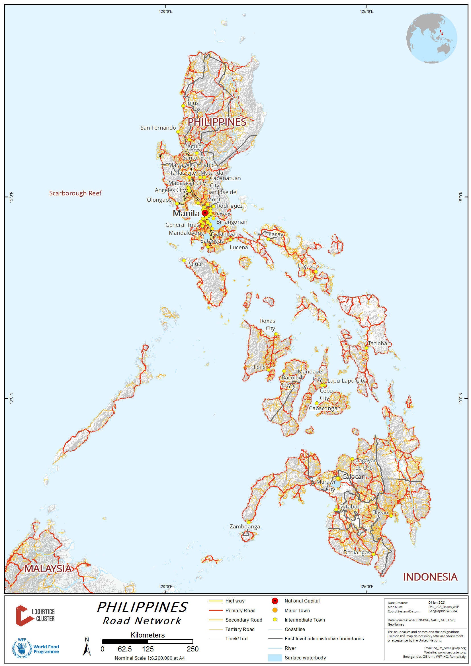
2.3 Philippines Road Network

4.1 Philippines Government Contact List
Further information on the Departmen of Public Works and Highways can be found in the following document:
Philippines Road
Assessment Additional Information
Distance Matrix
|
Distances from Capital City to Major Towns (km) |
||||||||
|---|---|---|---|---|---|---|---|---|
|
|
Manila |
Baguio |
San Fernando, La Union |
Laoag City, Illocos Norte |
Tuguegarao, Cagayan |
Bontoc, Mountain Province |
Pagsanjan, Laguna |
Legazpi City, Bicol |
|
Manila |
|
246 |
264 |
477 |
483 |
394 |
102 |
538 |
|
Baguio |
246 |
|
47 |
254 |
230 |
101 |
308 |
711 |
|
San Fernando, La Union |
264 |
47 |
|
406 |
408 |
274 |
335 |
540 |
|
Laoag City, Illocos Norte |
477 |
254 |
406 |
|
180 |
230 |
550 |
975 |
|
Tuguegarao, Cagayan |
483 |
230 |
408 |
180 |
|
130 |
526 |
964 |
|
Bontoc, Mountain Province |
394 |
101 |
274 |
230 |
130 |
|
416 |
842 |
|
Pagsanjan, Laguna |
102 |
308 |
335 |
550 |
526 |
416 |
|
403 |
|
Legazpi City, Bicol |
538 |
711 |
540 |
975 |
964 |
842 |
403 |
|
Travel Time Matrix
|
Travel Time from Capital City to Major Towns (hours) |
||||||||
|---|---|---|---|---|---|---|---|---|
|
|
Manila |
Baguio |
San Fernando, La Union |
Laoag City, Illocos Norte |
Tuguegarao, Cagayan |
Bontoc, Mountain Province |
Pagsanjan, Laguna |
Legazpi City, Bicol |
|
Manila |
|
5 |
4 |
10 |
12 |
7 |
1.5 |
12 |
|
Baguio |
5 |
|
2 |
5 |
7 |
2 |
8 |
17 |
|
San Fernando, La Union |
4 |
2 |
|
6 |
8 |
5 |
6 |
16 |
|
Laoag City, Illocos Norte |
10 |
5 |
6 |
|
8 |
7 |
12 |
22 |
|
Tuguegarao, Cagayan |
12 |
7 |
8 |
8 |
|
6 |
14 |
24 |
|
Bontoc, Mountain Province |
7 |
2 |
5 |
7 |
6 |
|
9 |
19 |
|
Pagsanjan, Laguna |
1.5 |
8 |
6 |
12 |
14 |
9 |
|
12 |
|
Legazpi City, Bicol |
12 |
17 |
16 |
22 |
24 |
19 |
12 |
|
Due to traffic congestion, all times are best approximations only and may be out by several hours depending on traffic. Travel times are based on car travel. Travel by truck or bus will increase travel times.
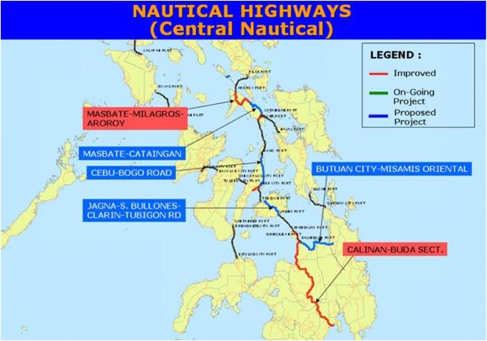
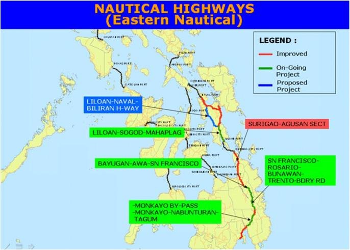
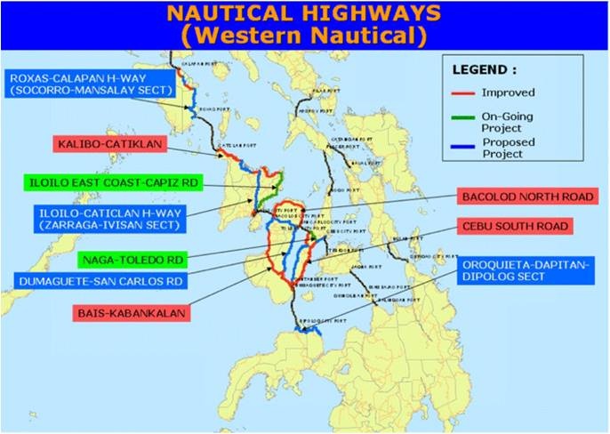
Transport Corridors
The main transport Corridor in the Philippines is an integrated network of highways and vehicle ferries that form the Strong Republic Nautical Highway (SRNH). The 919 kilometres SRNH covers the provinces and cities of Oriental Mindoro, Tagaytay City (Cavite), Marindugue, Romblon, and Batangas City in Luzon; Aklan, Antique, Iloilo, Capiz, Negros Oriental, Negros Occidental, Bohol, Bebu, Guimaras and Siguijor in the Visayas; and Misamis Occidental, Misamis Oriental, Lanao del Norte and Dapitan City in Mindanao.

Road Security
Security Level: Good
Road security in the Philippines is generally good. However there are a few problem areas which transporters will know about. Areas around Apayo (Ilocos) and Maguindanao (Mindanao) have reported unauthorised roadblocks where drivers have been forced to handover money, weapons and any high-end goods. Cargo (including food) is generally unaffected.
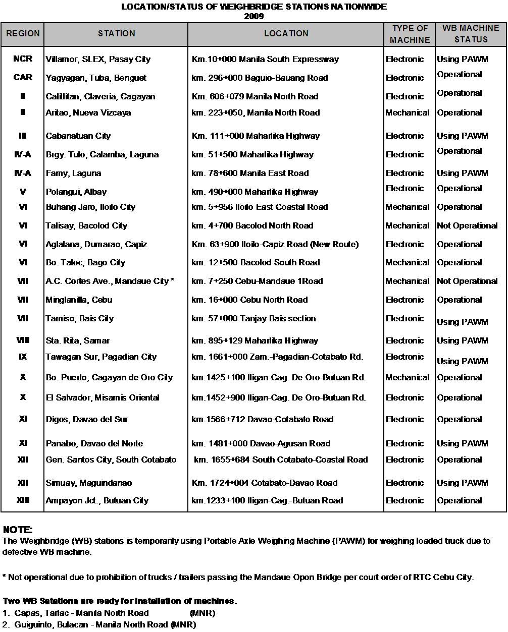
Weighbridges and Axle Load Limits
Weighbridges
Weighbridges are operational 24 hours and are well-signed upon approach. They are under the management of the Department of Public Works and Highways and the exact locations are listed below.
Axle Load Limits
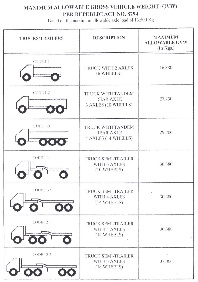
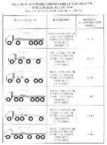
Bridges
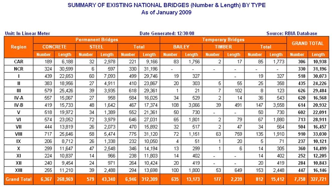
Bridges in the Philippines are prone to collapse during typhoons and landslides. Under regular use most bridges in the Philippines do not pose any particular problems, although drivers should note that sometimes they are inadequately signed and without load limits. In some cases, bridges may have a capacity less than the regular traffic load of the road and as a result, occasionally collapse, however DPWH pointed out this usually only occurs when transporters over-load their vehicles.
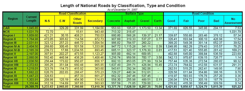
Road Class and Surface Conditions
Road Construction / Maintenance
In general, there are three type of maintenance conducted within the Philippines; periodic, preventative and routine. Further information on ongoing construction and maintenance projects can be found on the Department of Public Works and Highways website: http://www.dpwh.gov.ph/ and through the relevant Bureaus which can be contacted through the main telephone line.
Road Classification
Road classification in the Philippines is completed based on the strategic importance of the road. Road classification does not indicate the surface, quality or width of the road.
| Classification | Description |
|---|---|
|
Primary/National/Arterial (includes the North-South, East-West
and Other Roads classifications in the table below)
|
Main roads in the Philippines that form the backbone of the
road network. Surfaces can be concrete, asphalt, gravel or
earth.
|
|
Secondary
|
Secondary roads do not have as many connecting roads as the
primary roads. Surfaces can be concrete, asphalt, gravel or
earth.
|
|
Local
|
Local road classification includes all other provincial,
municipal, city and barangay roads. Surfaces can be concrete,
asphalt, gravel or earth.
|
Further information on the Road Network of the Philippines can be found on the following webpage: Road and Bridge Information Application (RBIA)
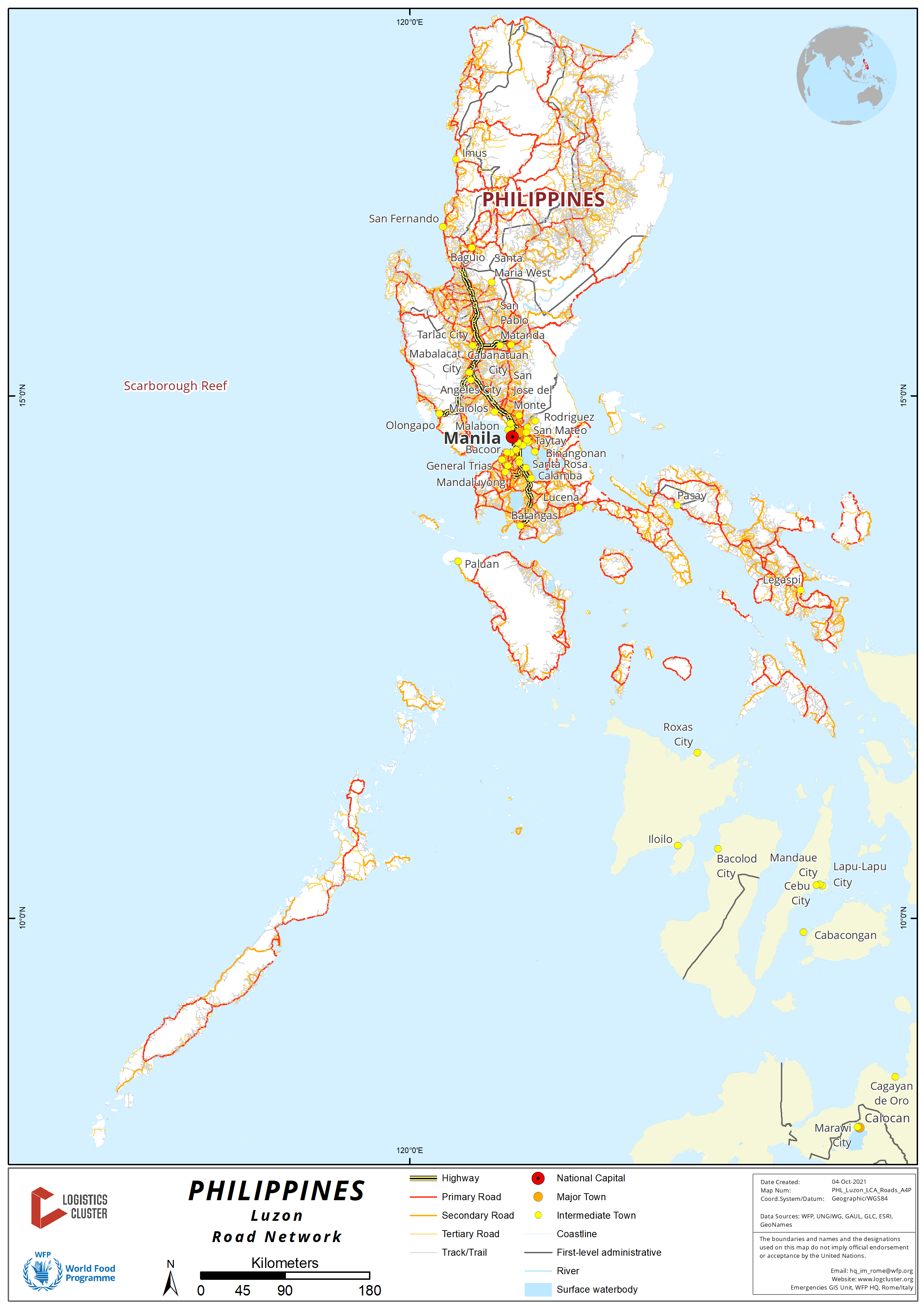
2.3.1 Philippines - Luzon Road Network
For more information on government contact details, please see the following link: 4.1 Government Contact List.
Distance Matrix
|
Distances from Capital City to Major Towns (Region 1) |
|||||||
|---|---|---|---|---|---|---|---|
|
Manila |
Clark, Angeles City |
Subic, Olongapo City |
Dagupan City |
San Fernando, La Union |
Vigan City |
Laoag City |
|
|
Manila |
93 km |
161 km |
223 km |
273 km |
410 km |
488 km |
|
|
Clark, Angeles City |
93 km |
68 km |
130 km |
180 km |
317 km |
395 km |
|
|
Subic, Olongapo City |
161 km |
68 km |
62 km |
112 km |
249 km |
327 km |
|
|
Dagupan City |
223 km |
130 km |
62 km |
50 km |
187 km |
265 km |
|
|
San Fernando, La Union |
273 km |
180 km |
112 km |
50 km |
137 km |
215 km |
|
|
ViganCity |
410 km |
317 km |
249 km |
187 km |
137 km |
78 km |
|
|
Laoag City |
488 km |
395 km |
327 km |
265 km |
215 km |
78 km |
|
| Distances from Capital City to Major Towns (Region 2) | |||||||
|---|---|---|---|---|---|---|---|
|
|
Manila | Cabanatuan City, Nueva Ecija* | Bayombong, Nueva Vizcaya | Santiago City, Isabela | Ilagan City, Isabela | Tuguegarao City, Cagayan | Aparri, Cagayan |
| Manila | 167 km | 303 km | 364 km | 442 km | 491 km | 594 km | |
| Cabanatuan City, Nueva Ecija (Region 3)* | 167 km | 136 km | 197 km | 275 km | 324 km | 427 km | |
| Bayombong, Nueva Vizcaya | 303 km | 136 km | 61 km | 139 km | 188 km | 291 km | |
| Santiago City, Isabela | 364 km | 197 km | 61 km | 78 km | 127 km | 230 km | |
| Ilagan City, Isabela | 442 km | 275 km | 139 km | 78 km | 49 km | 152 km | |
| Tuguegarao City, Cagayan | 491 km | 324 km | 188 km | 127 km | 49 km | 103 km | |
| Aparri, Cagayan | 594 km | 427 km | 291 km | 230 km | 152 km | 103 km | |
*Cabanatuan City is a major jump-off point to Region 2 cities.
|
Distances from Capital City to Major Towns (Region 3 and Route to Cordillera Administrative Region) |
||||||||
|---|---|---|---|---|---|---|---|---|
|
Manila |
Malolos, Bulacan |
San Fernando, Pampanga |
Tarlac City, Tarlac |
Baguio City |
Bontoc, Mountain Province |
Tabuk, Kalinga |
Kabugao, Apayao |
|
| Manila |
|
48 km |
70 km |
137 km |
253 km |
395 km |
471 km |
595 km |
| Malolos, Bulacan |
48 km |
|
22 km |
89 km |
205 km |
347 km |
423 km |
547 km |
| San Fernando, Pampanga |
70 km |
22 km |
|
67 km |
183 km |
325 km |
401 km |
525 km |
| Tarlac City, Tarlac |
137 km |
89 km |
67 km |
|
116 km |
258 km |
334 km |
458 km |
| Baguio City |
253 km |
205 km |
183 km |
116 km |
|
142 km |
218 km |
342 km |
| Bontoc, Mountain Province |
395 km |
347 km |
325 km |
258 km |
142 km |
|
76 km |
200 km |
| Tabuk, Kalinga |
471 km |
423 km |
401 km |
334 km |
218 km |
76 km |
124 km |
|
| Kabugao, Apayao |
595 km |
547 km |
525 km |
458 km |
342 km |
200 km |
124 km |
|
|
Distances from Capital City to Major Towns (Aurora) |
||||
|---|---|---|---|---|
|
Manila |
Cabarroguis, Quirino |
Baler, Aurora |
Casiguran, Aurora |
|
|
Manila |
|
375 km |
291 km |
376 km |
|
Cabarroguis, Quirino |
375 km |
|
156 km |
145 km |
|
Baler, Aurora |
291 km |
156 km |
|
85 km |
|
Casiguran, Aurora |
376 km |
145 km |
85 km |
|
|
Distances from Capital City to Major Towns (This route will lead to the island of Mindoro via Batangas Port RORO) |
||||||||
|---|---|---|---|---|---|---|---|---|
|
Manila |
Calamba, Laguna |
Santo Tomas, Batangas |
Lipa City, Batangas |
Batangas Port, Batangas City |
Calapan, Oriental Mindoro |
Roxas, Oriental Mindoro |
San Jose, Occidental Mindoro |
|
|
Manila |
|
55 km |
70 km |
104 km |
129 km |
216 km |
304 km |
404 km |
|
Calamba, Laguna |
55 km |
|
15 km |
49 km |
74 km |
161 km |
249 km |
349 km |
|
Santo Tomas, Batangas |
70 km |
15 km |
|
34 km |
59 km |
146 km |
234 km |
334 km |
|
Lipa City, Batangas |
104 km |
49 km |
34 km |
|
25 km |
112 km |
200 km |
300 km |
|
Batangas Port, Batangas City |
129 km |
74 km |
59 km |
25 km |
|
87 km |
175 km |
275 km |
|
Calapan, Oriental Mindoro |
216 km |
161 km |
146 km |
112 km |
87 km |
|
88 km |
188 km |
|
Roxas, Oriental Mindoro |
304 km |
249 km |
234 km |
200 km |
175 km |
88 km |
|
100 km |
|
San Jose, Occidental Mindoro |
337 km |
282 km |
267 km |
233 km |
208 km |
188 km |
100 km |
|
|
Distances from Capital City to Major Towns (This route will lead to the island of Samar via Matnog Port RORO) |
|||||||
|---|---|---|---|---|---|---|---|
|
Manila |
Lucena City, Quezon |
Naga, Camarines Sur |
Tabaco City, Albay |
Legazpi City, Albay |
Sorsogon City, Sorsogon |
Matnog Port, Sorsogon |
|
|
Manila |
|
133 km |
382 km |
473 km |
501 km |
557 km |
621 km |
|
Lucena City, Quezon |
133 km |
|
249 km |
340 km |
368 km |
424 km |
488 km |
|
Naga, Camarines Sur |
382 km |
249 km |
|
91 km |
119 km |
175 km |
239 km |
|
Tabaco City, Albay |
473 km |
340 km |
91 km |
|
28 km |
84 km |
148 km |
|
Legazpi City, Albay |
501 km |
368 km |
119 km |
28 km |
|
56 km |
120 km |
|
Sorsogon City, Sorsogon |
557 km |
424 km |
175 km |
84 km |
56 km |
|
64 km |
|
Matnog Port, Sorsogon |
621 km |
488 km |
239 km |
148 km |
120 km |
64 km |
|
|
Distances from Capital City to Major Towns (This route will lead to the island of Catanduanes via Tabaco Port RORO) |
|||||
|---|---|---|---|---|---|
|
Manila |
Lucena City, Quezon |
Naga, Camarines Sur |
Tabaco City, Albay |
Virac, Catanduanes |
|
|
Manila |
|
133 km |
382 km |
473 km |
543 km |
|
Lucena City, Quezon |
133 km |
|
249 km |
340 km |
410 km |
|
Naga, Camarines Sur |
382 km |
249 km |
|
91 km |
161 km |
|
Tabaco City, Albay |
473 km |
340 km |
91 km |
|
70 km |
|
Virac, Cantanduanes |
543 km |
410 km |
161 km |
70 km |
|
|
Distances from Capital City to Major Towns (This route will lead to the island of Marinduque via RORO in Lucena Port) |
||||
|---|---|---|---|---|
|
Manila |
Lucena City, Quezon |
Boac, Marinduque |
Mogpog, Marinduque |
|
|
Manila |
|
133 km |
223 km |
230 km |
|
Lucena City, Quezon |
133 km |
90 km |
97 km |
|
|
Boac, Marinduque |
223 km |
90 km |
|
7 km |
|
Mogpog, Marinduque |
230 km |
97 km |
7 km |
|
|
Distances from Capital City to Major Towns (km) (This route will lead to the island of Romblon via RORO in Roxas Port, Oriental Mindoro) |
||||||
|---|---|---|---|---|---|---|
|
Manila |
Batangas Port, Batangas |
Calapan, Oriental Mindoro |
Roxas Port, Roxas Oriental Mindoro |
Odiongan, Tablas |
Romblon, Romblon |
|
|
Manila |
|
129 km |
216 km |
304 km |
363 km |
437 km |
|
Batangas Port, Batangas |
129 km |
|
87 km |
175 km |
234 km |
308 km |
|
Calapan, Oriental Mindoro |
216 km |
87 km |
|
88 km |
147 km |
221 km |
|
Roxas Port, Roxas Oriental Mindoro |
304 km |
175 km |
88 km |
|
59 km |
133 km |
|
Odiongan, Tablas |
363 km |
234 km |
147 km |
59 km |
|
74 km |
|
Romblon, Romblon |
437 km |
308 km |
221 km |
133 km |
74 km |
|
|
Distances from Capital City to Major Towns (km) (This route will lead to the island of Masbate via Pilar, Sorsogon RORO but there are also direct shipping lanes from Manila Domestic Port to Masbate) |
|||||
|---|---|---|---|---|---|
|
Manila |
Legazpi City, Albay |
Pilar Port in Pilar, Sorsogon |
Aroroy Port in Aroroy, Masbate |
Masbate City, Masbate |
|
|
Manila |
|
501 km |
551 km |
611 km |
651 km |
|
Legazpi City, Albay |
501 km |
|
50 km |
110 km |
150 km |
|
Pilar Port in Pilar, Sorsogon |
551 km |
50 km |
|
60 km |
100 km |
|
Aroroy Port in Aroroy, Masbate |
611 km |
110 km |
60 km |
|
40 km |
|
Masbate City, Masbate |
651 km |
150 km |
100 km |
40 km |
|
|
Travel Time from Capital City to Major Towns (Region 1) |
|||||||
|---|---|---|---|---|---|---|---|
|
Manila |
Clark, Angeles City |
Subic, Olongapo City |
Dagupan City |
San Fernando, La Union |
Vigan City |
Laoag City |
|
|
Manila |
2 hours |
3 hours |
5 hours |
6 hours |
10 hours |
12 hours |
|
|
Clark, Angeles City |
2 hours |
1 hours |
3 hours |
4 hours |
5 hours |
7 hours |
|
|
Subic, Olongapo City |
3 hours |
1 hour |
3 hours |
4 hours |
5 hours |
7 hours |
|
|
Dagupan City |
5 hours |
3 hours |
3 hours |
2 hours |
4 hours |
5 hours |
|
|
San Fernando, La Union |
6 hours |
4 hours |
4 hours |
2 hours |
3 hours |
4 hours |
|
|
Vigan City |
10 hours |
5 hours |
5 hours |
4 hours |
3 hours |
2 hours |
|
|
Laoag City |
12 hours |
7 hours |
7 hours |
5 hours |
4 hours |
2 hours |
|
|
Travel Time from Capital City to Major Towns (Region 2) |
|||||||
|---|---|---|---|---|---|---|---|
|
Manila |
Cabanatuan City, Nueva Ecija |
Bayombong, Nueva Vizcaya |
Santiago City, Isabela |
Ilagan City, Isabela |
Tuguegarao City, Cagayan |
Aparri, Cagayan |
|
|
Manila |
3 hours |
5 hours |
6 hours |
7 hours |
8 hours |
11 hours |
|
|
Cabanatuan City, Nueva Ecija |
3 hours |
3 hours |
5 hours |
7 hours |
8 hours |
10 hours |
|
|
Bayombong, Nueva Vizcaya |
5 hours |
3 hours |
3 hours |
5 hours |
7 hours |
8 hours |
|
|
Santiago City, Isabela |
6 hours |
5 hours |
3 hours |
2 hours |
4 hours |
7 hours |
|
|
Ilagan City, Isabela |
7 hours |
7 hours |
5 hours |
2 hours |
2 hours |
6 hours |
|
|
Tuguegarao City, Cagayan |
8 hours |
8 hours |
7 hours |
4 hours |
2 hours |
4 hours |
|
|
Aparri, Cagayan |
11 hours |
10 hours |
8 hours |
7 hours |
6 hours |
4 hours |
|
|
Travel Time from Capital City to Major Towns (Region 3 and route to Cordillera Administrative Region) |
||||||||
|---|---|---|---|---|---|---|---|---|
|
Manila |
Malolos, Bulacan |
San Fernando, Pampanga |
Tarlac City |
Baguio City |
Bontoc, Mountain Province |
Tabuk, Kalinga |
Kabugao, Apayao |
|
|
Manila |
1 hour |
2 hours |
4 hours |
7 hours |
8 hours |
10 hours |
12 hours |
|
|
Malolos, Bulacan |
1 hour |
2 hours |
3 hours |
6 hours |
7 hours |
9 hours |
11 hours |
|
|
San Fernando, Pampanga |
2 hours |
2 hours |
2 hours |
5 hours |
6 hours |
8 hours |
10 hours |
|
|
Tarlac City |
4 hours |
3 hours |
2 hours |
4 hours |
5 hours |
7 hours |
9 hours |
|
|
Baguio City |
7 hours |
6 hours |
5 hours |
4 hours |
3 hours |
5 hours |
6 hours |
|
|
Bontoc, Mountain Province |
8 hours |
7 hours |
6 hours |
5 hours |
3 hours |
2 hours |
4 hours |
|
|
Tabuk, Kalinga |
10 hours |
9 hours |
8 hours |
7 hours |
5 hours |
2 hours |
2 hours |
|
|
Kabugao, Apayao |
12 hours |
11 hours |
10 hours |
8 hours |
6 hours |
4 hours |
2 hours |
|
|
Travel Time from Capital City to Major Towns (Aurora) |
||||
|---|---|---|---|---|
|
Manila |
Cabarroguis, Quirino |
Baler, Aurora |
Casiguran, Aurora |
|
|
Manila |
6 hours |
7 hours |
8 hours |
|
|
Cabarroguis, Quirino |
6 hours |
3 hours |
4 hours |
|
|
Baler, Aurora |
7 hours |
3 hours |
2 hours |
|
|
Casiguran, Aurora |
8 hours |
4 hours |
2 hours |
|
|
Travel Time from Capital City to Major Towns (This route will lead to the island of Mindoro via Batangas Port seacraft) |
||||||||
|---|---|---|---|---|---|---|---|---|
|
Manila |
Calamba, Laguna |
Santo Tomas, Batangas |
Lipa City, Batangas |
Batangas Port, Batangas City |
Calapan, Oriental Mindoro |
Roxas, Oriental Mindoro |
San Jose, Occidental Mindoro |
|
|
Manila |
2 hours |
3 hours |
4 hours |
5 hours |
10 hours |
13 hours |
15 hours |
|
|
Calamba, Laguna |
2 hours |
1 hour |
2 hours |
3 hours |
8 hours |
11 hours |
13 hours |
|
|
Santo Tomas, Batangas |
3 hours |
1 hour |
1 hour |
2 hours |
7 hours |
10 hours |
12 hours |
|
|
Lipa City, Batangas |
4 hours |
2 hours |
1 hour |
1 hour |
6 hours |
9 hours |
11 hours |
|
|
Batangas Port, Batangas City |
5 hours |
3 hours |
2 hours |
1 hour |
5 hours |
8 hours |
10 hours |
|
|
Calapan, Oriental Mindoro |
10 hours |
8 hours |
7 hours |
6 hours |
5 hours |
3 hours |
5 hours |
|
|
Roxas, Oriental Mindoro |
13 hours |
11 hours |
10 hours |
9 hours |
8 hours |
3 hours |
2 hours |
|
|
San Jose, Occidental Mindoro |
15 hours |
13 hours |
12 hours |
11 hours |
10 hours |
5 hours |
2 hours |
|
|
Travel Time from Capital City to Major Towns (This route will lead to the island of Samar via Matnog Port seacraft) |
|||||||
|---|---|---|---|---|---|---|---|
|
Manila |
Lucena City, Quezon |
Naga, Camarines Sur |
Tabaco City, Albay |
Legazpi City, Albay |
Sorsogon City, Sorsogon |
Matnog Port in Matnog, Sorsogon |
|
|
Manila |
5 hours |
12 hours |
15 hours |
18 hours |
22 hours |
26 hours |
|
|
Lucena City, Quezon |
5 hours |
8 hours |
11 hours |
14 hours |
20 hours |
24 hours |
|
|
Naga, Camarines Sur |
12 hours |
8 hours |
4 hours |
7 hours |
13 hours |
17 hours |
|
|
Tabaco City, Albay |
15 hours |
11 hours |
4 hours |
2 hours |
8 hours |
12 hours |
|
|
Legazpi City, Albay |
18 hours |
14 hours |
7 hours |
2 hours |
2 hours |
8 hours |
|
|
Sorsogon City, Sorsogon |
22 hours |
20 hours |
13 hours |
8 hours |
2 hours |
4 hours |
|
|
Matnog Port in Matnog, Sorsogon |
26 hours |
24 hours |
17 hours |
12 hours |
8 hours |
4 hours |
|
|
Travel Time from Capital City to Major Towns (This route will lead to the island of Catanduanes via Tabaco Port seacraft) |
|||||
|---|---|---|---|---|---|
|
Manila |
Lucena City, Quezon |
Naga, Camarines Sur |
Tabaco City, Albay |
Virac, Catanduanes |
|
|
Manila |
5 hours |
12 hours |
15 hours |
20 hours |
|
|
Lucena City, Quezon |
5 hours |
7 hours |
10 hours |
15 hours |
|
|
Naga, Camarines Sur |
12 hours |
7 hours |
3 hours |
5 hours |
|
|
Tabaco City, Albay |
15 hours |
10 hours |
3 hours |
5 hours |
|
|
Virac, Cantanduanes |
20 hours |
15 hours |
5 hours |
5 hours |
|
|
Travel Time from Capital City to Major Towns (This route will lead to the island of Marinduque via Lucena Port seacraft) |
||||
|---|---|---|---|---|
|
Manila |
Lucena City, Quezon |
Boac, Marinduque |
Mogpog, Marinduque |
|
|
Manila |
5 hours |
8 hours |
9 hours |
|
|
Lucena City, Quezon |
5 hours |
3 hours |
4 hours |
|
|
Boac, Marinduque |
8 hours |
3 hours |
1 hour |
|
|
Mogpog, Marinduque |
9 hours |
4 hours |
1 hour |
|
|
Travel Time from Capital City to Major Towns (This route will lead to the island of Romblon via Roxas Port in Oriental Mindoro) |
||||||
|---|---|---|---|---|---|---|
|
Manila |
Batangas Port, Batangas |
Calapan, Oriental Mindoro |
Roxas Port in Roxas, Oriental Mindoro |
Odiongan, Tablas |
Romblon, Romblon |
|
|
Manila |
5 hours |
10 hours |
13 hours |
15 hours |
18 hours |
|
|
Batangas Port, Batangas |
5 hours |
5 hours |
8 hours |
10 hours |
13 hours |
|
|
Calapan, Oriental Mindoro |
10 hours |
5 hours |
3 hours |
5 hours |
8 hours |
|
|
Roxas Port in Roxas, Oriental Mindoro |
13 hours |
8 hours |
3 hours |
2 hours |
5 hours |
|
|
Odiongan, Tablas |
15 hours |
10 hours |
5 hours |
2 hours |
3 hours |
|
|
Romblon, Romblon |
18 hours |
13 hours |
8 hours |
5 hours |
3 hours |
|
|
Travel Time from Capital City to Major Towns (This route will lead to the island of Masbate via Pilar, Sorsogon seacraft, but has also direct shipping lanes from Manila Domestic Port to Masbate |
||||||
|---|---|---|---|---|---|---|
|
Manila |
Batangas Port, Batangas |
Calapan, Oriental Mindoro |
Roxas Port in Roxas, Oriental Mindoro |
Odiongan, Tablas |
Romblon, Romblon |
|
|
Manila |
5 hours |
10 hours |
13 hours |
15 hours |
18 hours |
|
|
Batangas Port, Batangas |
5 hours |
5 hours |
8 hours |
10 hours |
13 hours |
|
|
Calapan, Oriental Mindoro |
10 hours |
5 hours |
3 hours |
5 hours |
8 hours |
|
|
Roxas Port in Roxas, Oriental Mindoro |
13 hours |
8 hours |
3 hours |
2 hours |
5 hours |
|
|
Odiongan, Tablas |
15 hours |
10 hours |
5 hours |
2 hours |
3 hours |
|
|
Romblon, Romblon |
18 hours |
13 hours |
8 hours |
5 hours |
3 hours |
|
Road Security
There are no major issues regarding road security in Luzon. Transporters can travel 24/7 in Luzon-wide transport road network except in local governments where timed truck bans and allowable load capacity are imposed. Dalton Pass in Nueva Ecija going to Nueva Vizcaya, Isabela and Cagayan is dangerous, drivers should be careful due to zigzag and uphill road path. For information on Metropolitan Manila Development Authority (MMDA) truck bans, please see the following link: https://mmda.gov.ph/20-faq/299-truck-ban-ordinance.html. 12 – 14 wheeler trucks are temporarily not allowed in the North Luzon Expressway (NLEX) due to repairs made in Candaba Viaduct. Expressways will not allow vehicles with total height exceeding 7.5 meters. Please see the following link for vehicle classifications: http://www.trb.gov.ph/8-transparency/39-vehicle-classifications.html.
Toll Fees can be checked through the links below:
Weighbridges and Axle Load Limits
12 – 14 wheeler trucks are temporarily not allowed in NLEX due to repairs made in Candaba Viaduct. Expressway load limit for 10-wheeler (3-axle) load limit 13.5 MT. Non-expressway road networks like McArthur Highway load limits are based on truck capacity.
2.3.2 Philippines - Visayas Road Network
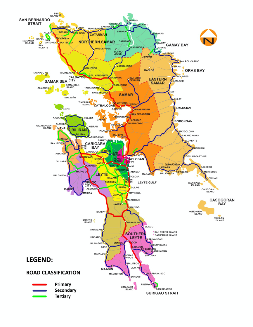
Eastern Visayas
The road network in Region 8 is well developed and maintained. Primary roads are generally 4 ways but concrete paved and rarely asphalted decreasing the speed limit.
The weight limitation is 23 MT on the primary roads, 15 MT on the secondary roads and can be less on the tertiaries. The 15 MT is used as a safety measure as the Department of Public Works and Highway (DPWH) is conducting a review to allow heavier vehicles in the future.
The Eastern Visayas Islands own some of the most famous bridges of Philippines including the longest and the tallest road structures.
- San Juanico Bridge: San Juanico Bridge connects the islands of Leyte and Samar by linking the city of Tacloban to the town of Santa Rita, Samar. It passes over the San Juanico Strait. It is the longest bridge in the Philippines measuring 2,164m. The weight limitation is 23 MT (Gross weight).
- Agas-Agas Bridge: The Agas-Agas Bridge is the highest bridge ever built in the Philippines. It is constructed between two mountains and crosses the Mahaplag-Sogod section of Maharlika Highway. The bridge is located in Sogod, Southern Leyte and provides a significant link to travellers coming from Luzon or Mindanao. It was built to avoid the perennial landslide danger in the area during heavy rains. It keeps the Mahaplag-Sogod open and safe by creating the by-pass of the original road that was build on the side of the mountain. The weight limitation is 23 MT (Gross weight).
- Wawa bridge: Wawa Bridge is located in Liloan, Southern Leyte. It connects Panaon Island and the mainland of Leyte. The weight limitation is 15 MT (Gross weight).
- Biliran Bridge: The Biliran Bridge serves as a link between the islands and provinces of Biliran and Leyte. Spans across a very narrow channel around 100m below it. It is approximately 150m long. The weight limitation is 15 MT (Gross weight).
For more information on government contact details, please see the following link: 4.1 Philippines Visayas Government Contact List
Distance Matrix
|
Distances from Capital City to Major Towns (km) |
||||||||
|
|
Tacloban |
Ormoc |
Baybay |
Maasin |
Naval |
Catbalogan |
Catarman |
Borongan |
|
Tacloban |
|
108 |
104 |
178 |
120 |
106 |
251 |
193 |
|
Ormoc |
108 |
|
46 |
74 |
87 |
210 |
355 |
297 |
|
Baybay |
104 |
46 |
|
77 |
133 |
207 |
251 |
294 |
|
Maasin |
178 |
74 |
77 |
|
210 |
281 |
425 |
368 |
|
Naval |
120 |
87 |
133 |
210 |
|
223 |
367 |
310 |
|
Catbalogan |
106 |
210 |
207 |
281 |
223 |
|
145 |
136 |
|
Catarman |
251 |
355 |
251 |
425 |
367 |
145 |
|
256 |
|
Borongan |
193 |
297 |
294 |
368 |
310 |
136 |
256 |
|
|
Travel Time from Capital City to Major Towns (hours) |
||||||||
|
|
Tacloban |
Ormoc |
Baybay |
Maasin |
Naval |
Catbalogan |
Catarman |
Borongan |
|
Tacloban |
|
1.50 |
1.45 |
3 |
2 |
1.45 |
4.30 |
3.30 |
|
Ormoc |
1.50 |
|
0.50 |
1.15 |
1.30 |
3.30 |
6 |
5 |
|
Baybay |
1.45 |
0.50 |
|
1.20 |
2.15 |
3.30 |
4.15 |
5 |
|
Maasin |
3 |
1.15 |
1,20 |
|
3.30 |
3 |
7 |
6.15 |
|
Naval |
2 |
1.30 |
2.15 |
3.30 |
|
3.45 |
6.15 |
5.15 |
|
Catbalogan |
1.45 |
3.30 |
3.30 |
3 |
3.45 |
|
2.30 |
2.20 |
|
Catarman |
4.30 |
6 |
4.15 |
7 |
6.15 |
2.30 |
|
4,20 |
|
Borongan |
3.30 |
5 |
5 |
6.15 |
5.15 |
2.20 |
4.20 |
|
Road Security
Security Level: Good
Roads are in good conditions, and most users respect the speed limits. Drivers are used to but they can sometime be dangerous due to the large amount of motorbikes, motorised tricycles, or other public transports that might come to halt in the middle of the road at any time.
2.3.3 Philippines - Mindanao Road Network
Overview
For more information on government contact details, please see the following link: 4.1 Government Contact List.
For more information about the Philippine road network, please see the following link: 2020 DPWH Road and Bridges Inventory Survey.
Zamboanga Peninsula (Region IX)
As of 2018, Department of Public Works and Highways (DPWH) IX was able to build 56.49 km of national roads along the priority corridors, widened with complete features to 4 lanes, which is 9.16 km short of the target of 65.65 km. A total of 24.05 km of new roads were constructed to close gaps in the national road network which is 4.78 km or 16.58% less than the total target of 28.83 km.
Northern Mindanao (Region X)
Coming from Cagayan de Oro City going east, the road networks will lead to Bukidnon and eastern part of Misamis Oriental up to its chartered city of Gingoog. From Cagayan de Oro going westward the road networks will lead to western part of Misamis Oriental, Iligan City, Province of Lanao del Norte, Marawi City, Lanao del Sur, Zamboanga City and its northern part road network going to Dipolog City. Challenges on this road network are damaged bridges cause by natural calamities. Additional development and construction of new bridges and road widening are underway to lessen the travel time in going to other regions. The Department of Public Works and Highways (DPWH) is the lead government agency for road repairs and widening to cope with the growing economy in Region X and its adjacent Regions of IX and Basilan, Sulu, and Tawi-Tawi (BASULTA) provinces.
Davao Region (Region XI)
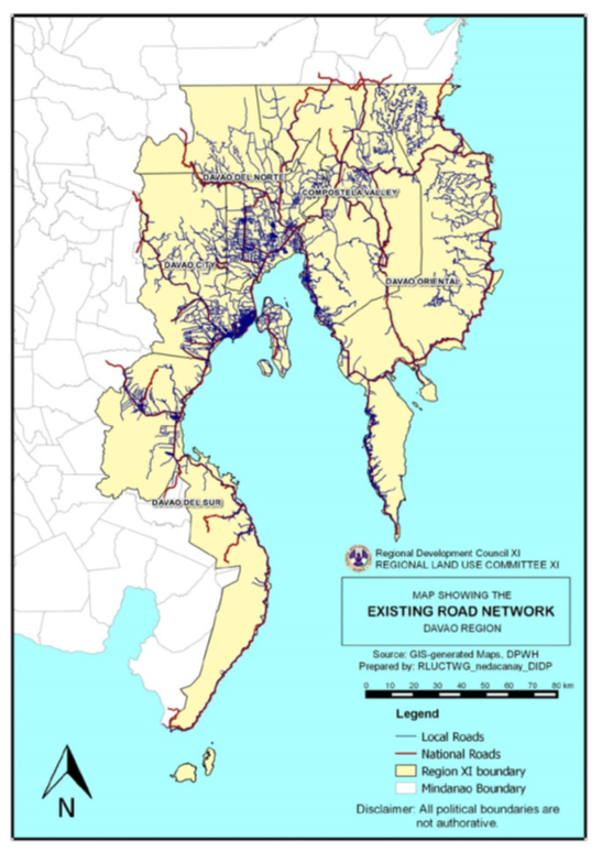
Davao Region Road Network. Source: Davao Regional Land Use Committee
The road system of Davao Region is comprised of national and local road networks connecting the regional center externally and internally, particularly the provincial capitals and strategic destinations in the region.
As of December 2013, the total national road network of Davao Region was 1,662.37 kilometers or 18 percent of the total national road network of Mindanao. Among the provinces/cities, Davao Oriental had the longest national road network and paved surface road length with 431.66 kilometers and 350.55 kilometers, respectively, while Digos City had the shortest length with 24.03 kilometers. In terms of the proportion of paved roads to total length of national roads, the cities of Digos, Panabo, IGACOS and Tagum posted the highest percentage with 100% of their national roads already paved, whereas Davao del Sur had the lowest pavement ratio with 44%.
The Road Inventory and Road Condition Survey conducted by DPWH in 2013 revealed that 61 percent of the national road network in the region (1,017.76 kilometers) was in good or fair condition. On the other hand, roads in poor condition had a total length of 268.03 kilometers while those in bad condition had a total length of 211.47 kilometers.
Currently, high traffic volumes are seen along the Region’s major thoroughfares, particularly along the Tagum-Panabo-Davao City-Digos corridor. The volume-capacity ratio (VCR) is the basis being used by DPWH in considering road sections to be widened, at a threshold of more than 0.5. As of CY 2013, 73 km of national roads in the Region had VCR of more than 0.5, with 72 km experiencing moderate to heavy traffic flow, and about 1 km in Davao City already with saturation traffic volumes. However, widening in these sections is contingent to the availability of road right-of-way. Traffic congestion is expected to worsen in the coming years due to population growth, increasing urbanization and heightened economic activities. Other options may have to be considered, such as the opening/upgrading to high standard highways and establishment of mass transit systems.
Davao Region Physical Framework Plan: http://nro11.neda.gov.ph/wp-content/uploads/2017/08/DRPFP-2015-2045.pdf
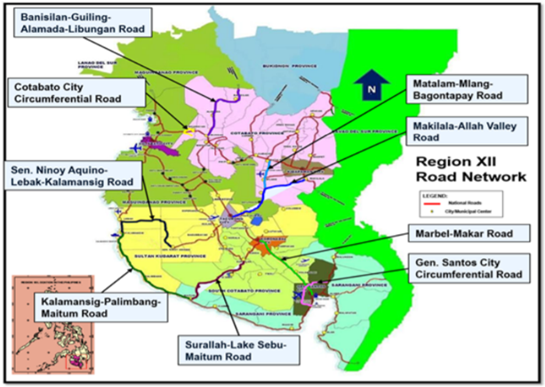
SOCCSKSARGEN (Region XII)
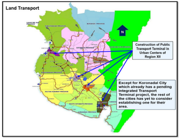
The region recognizes the importance of improving the transportation sector to support its rapid and inclusive economic growth. Prudent strategies were pursued and strategic projects were implemented to accelerate the development of the sector’s safe, reliable, cost-effective, and sustainable infrastructure facilities to ensure the efficient transport of people and products. Adhering to the policy of full transparency and accountability to its people, the region engaged the general public to participate in the governance, monitoring and feedback in the implementation of infrastructure projects. The implementation of strategic road projects has enhanced the accessibility to production areas, major tourism destinations and basic service facilities like schools, hospitals, and attracted investments to the region. In terms of providing an integrated transport terminal in urban centers in the region, Koronadal City has an ongoing construction of an Integrated Transport Terminal project.
Road Security
| Corridor | Comments |
|---|---|
|
Davao City – Butuan – Surigao City |
There are no reported security issues and transporters and buses are using this route network travel 24 hours a day. |
| Davao – Cagayan de Oro – Iligan City | Can be accessed 24 hours, but with caution at night due to fog along Calinan District, Davao City and Bukidnon Province. |
| Davao City – Davao de Oro – Tandag City, Surigao del Sur – Surigao City | This road network was noted to have rampant non-government actors especially along Surigao del Sur going to Surigao City. From Carrascal, Surigao del Sur to Surigao City, the KM 90 (Noventa) highway stretch has minimal population and is noted for highway robbery and hijacking. |
| Davao City – General Santos City |
This road network is accessible 24 hours a day with no reported security issues even though non-government actors are present. The stretch of roads in Malungon Municipality is prone to landslides during heavy rains. |
| General Santos City - Cotabato City | Travelling on this route at night is risky as lawless elements stage unauthorized checkpoints in order to commit robberies. |
| Cagayan de Oro City – Iligan City – Pagadian City – Zamboanga City | This road network is accessible 24 hours but observe precautionary measures at night especially on the highway from Pagadian City to Zamboanga City where long stretches of the road is sparsely populated. |
| Cagayan de Oro City – Butuan City – Surigao City | This road network is accessible 24 hours a day but caution is advised at night due to the large volume of trucks and buses heading to Manila and to Visayas. |
| Cagayan de Oro – Ozamis City – Oroquieta City – Dipolog/Dapitan City | This road network can be accessed any time of the day but take note that the RORO vessel docked at Mukas Port in the municipality of Kolambugan, Lanao del Norte has time off between 2000H to 0400H. As an alternative, travelers should take the long route via Aurora, Zamboanga del Sur to Molave, Zamboanga de Sur and then heading to Ozamis City all the way to Dipolog City. |
| Davao City – Kidapawan City – Cotabato City | Travelers can access this route any time of the day but UV Express passenger vans are known to drive carelessly along this route. |
Distance Matrices
Davao City – Butuan City – Surigao City
|
Distances from Davao to Major Towns in the Davao City - Butuan City - Surigao City Corridor |
||||||||
|---|---|---|---|---|---|---|---|---|
|
Davao City |
Panabo City |
Tagum City |
Nabunturan, Davao de Oro |
Montevista, Davao de Oro |
Monkayo, Davao de Oro |
Butuan City |
Surigao City |
|
|
Davao City |
|
29 km |
53 km |
86 km |
98 km |
116 km |
287 km |
392 km |
|
Panabo City |
29 km |
|
24 km |
57 km |
69 km |
87 km |
258 km |
363 km |
|
Tagum City |
53 km |
24 km |
|
33 km |
45 km |
63 km |
234 km |
339 km |
|
Nabunturan, Davao de Oro |
86 km |
57 km |
33 km |
|
12 km |
30 km |
201 km |
306 km |
|
Montevista, Davao de Oro |
98 km |
69 km |
45 km |
12 km |
|
18 km |
189 km |
294 km |
|
Monkayo, Davao de Oro |
116 km |
87 km |
63 km |
30 km |
18 km |
|
171 km |
276 km |
|
Butuan City |
287 km |
258 km |
234 km |
201 km |
189 km |
171 km |
|
105 km |
|
Surigao City |
392 km |
363 km |
339 km |
306 km |
294 km |
276 km |
105 km |
|
|
Travel Time from Davao to Major Towns in the Davao City - Butuan City - Surigao City Corridor |
||||||||
|---|---|---|---|---|---|---|---|---|
|
Davao City |
Panabo City |
Tagum City |
Nabunturan, Davao de Oro |
Montevista, Davao de Oro |
Monkayo, Davao de Oro |
Butuan City |
Surigao City |
|
|
Davao City |
|
1 hr |
1 hr |
2 hrs |
3 hrs |
4 hrs |
7 hrs |
10 hrs |
|
Panabo City |
1 hr |
|
1 hr |
1 hr |
3 hrs |
3 hrs |
7 hrs |
9 hrs |
|
Tagum City |
1 hr |
1 hrs |
|
1 hr |
2 hrs |
3 hrs |
6 hrs |
8 hrs |
|
Nabunturan, Davao de Oro |
2 hrs |
1 hrs |
1 hr |
|
1 hr |
2 hrs |
6 hrs |
7 hrs |
|
Montevista, Davao de Oro |
3 hrs |
3 hrs |
2 hrs |
1 hr |
|
1 hr |
5 hrs |
7 hrs |
|
Monkayo, Davao de Oro |
4 hrs |
3 hrs |
3 hrs |
2 hrs |
1 hr |
|
5 hrs |
7 hrs |
|
Butuan City |
7 hrs |
7 hrs |
6 hrs |
6 hrs |
5 hrs |
5 hrs |
|
3 hrs |
|
Surigao City |
9 hrs |
9 hrs |
8 hrs |
7 hrs |
7 hrs |
7 hrs |
3 hrs |
|
Davao City – Davao de Oro – Tandag, Surigao Sur – Surigao City
|
Distances from Davao City to Major Towns in the Davao City - Davao De Oro - Tandag - Surigao City Corridor |
||||||||
|---|---|---|---|---|---|---|---|---|
|
Davao City |
Mati City, Davao Oriental |
Tarragona, Davao Oriental |
Man-Ay, Davao Oriental |
Carraga, Davao Oriental |
Boston, Davao Oriental |
Tandag City |
Surigao City |
|
|
Davao City |
|
157 km |
196 km |
224 km |
244 km |
348 km |
566 km |
739 km |
|
Mati City, Davao Oriental |
157 km |
|
39 km |
67 km |
87 km |
191 km |
409 km |
582 km |
|
Tarragona, Davao Oriental |
196 km |
39 km |
|
28 km |
48 km |
152 km |
370 km |
543 km |
|
Man-Ay, Davao Oriental |
224 km |
67 km |
28 km |
|
20 km |
124 km |
342 km |
515 km |
|
Carraga, Davao Oriental |
244 km |
87 km |
48 km |
20 km |
|
104 km |
322 km |
495 km |
|
Boston, Davao Oriental |
348 km |
191 km |
152 km |
124 km |
104 km |
|
218 km |
391 km |
|
Tandag City |
566 km |
409 km |
370 km |
342 km |
322 km |
218 km |
|
173 km |
|
Surigao City |
739 km |
582 km |
543 km |
515 km |
495 km |
391 km |
173 km |
|
|
Travel Time from Davao City to Major Towns in the Davao City - Davao De Oro - Tandag - Surigao City Corridor |
||||||||
|---|---|---|---|---|---|---|---|---|
|
Davao City |
Mati City, Davao Oriental |
Tarragona, Davao Oriental |
Man-Ay, Davao Oriental |
Carraga, Davao Oriental |
Boston, Davao Oriental |
Tandag City |
Surigao City |
|
|
Davao City |
|
3 hrs |
4 hrs |
6 hrs |
6 hrs |
8 hrs |
10 hrs |
12 hrs |
|
Mati City, Davao Oriental |
3 hrs |
|
1 hr |
1 hr |
2 hrs |
5 hrs |
8 hrs |
10 hrs |
|
Tarragona, Davao Oriental |
4 hrs |
1 hr |
|
1 hr |
1 hr |
3 hrs |
7 hrs |
9 hrs |
|
Man-Ay, Davao Oriental |
6 hrs |
1 hr |
1 hr |
|
1 hr |
2 hrs |
6 hrs |
8 hrs |
|
Carraga, Davao Oriental |
6 hrs |
2 hrs |
1 hr |
1 hr |
|
2 hrs |
5 hrs |
7 hrs |
|
Boston, Davao Oriental |
8 hrs |
5 hrs |
3 hrs |
2 hrs |
2 hrs |
|
4 hrs |
6 hrs |
|
Tandag City |
10 hrs |
8 hrs |
7 hrs |
6 hrs |
5 hrs |
4 hrs |
|
5 hrs |
|
Surigao City |
12 hrs |
10 hrs |
9 hrs |
8 hrs |
7 hrs |
3 hrs |
5 hrs |
|
Davao City – Digos City – General Santos City – Cotabato City – Zamboanga City
|
Distances from Davao City to Major Towns in the Davao City - Digos City - General Santos City - Cotabato City - Zamboanga City Corridor |
||||||||
|---|---|---|---|---|---|---|---|---|
|
Davao City |
Digos City |
General Santos City |
Koronadal City |
Tacurong City |
Cotabato City |
Pagadian City |
Zamboanga City |
|
|
Davao City |
|
54 km |
141 km |
196 km |
234 km |
330 km |
510 km |
781 km |
|
Digos City |
54 km |
|
87 km |
142 km |
180 km |
276 km |
453 km |
727 km |
|
General Santos City |
141 km |
87 km |
|
55 km |
93 km |
189 km |
369 km |
640 km |
|
Koronadal City |
196 km |
142 km |
55 km |
|
38 km |
134 km |
314 km |
585 km |
|
Tacurong City |
234 km |
180 km |
93 km |
38 km |
|
96 km |
276 km |
547 km |
|
Cotabato City |
330 km |
276 km |
189 km |
134 km |
96 km |
|
180 km |
451 km |
|
Pagadian City |
510 km |
453 km |
369 km |
314 km |
276 km |
180 km |
|
271 km |
|
Zamboanga City |
781 km |
727 km |
640 km |
585 km |
547 km |
451 km |
271 km |
|
|
Travel Time from Davao City to Major Towns in the Davao City - Digos City - General Santos City - Cotabato City - Zamboanga City Corridor |
||||||||
|---|---|---|---|---|---|---|---|---|
|
Davao City |
Digos City |
General Santos City |
Koronadal City |
Tacurong City |
Cotabato City |
Pagadian City |
Zamboanga City |
|
|
Davao City |
|
1 hr |
3 hrs |
4 hrs |
6 hrs |
8 hrs |
12 hrs |
16 hrs |
|
Digos City |
1 hr |
|
2 hrs |
3 hrs |
5 hrs |
7 hrs |
11 hrs |
15 hrs |
|
General Santos City |
3 hrs |
2 hrs |
|
1 hr |
2 hrs |
6 hrs |
10 hrs |
14 hrs |
|
Koronadal City |
4 hrs |
3 hrs |
1 hr |
|
1 hr |
4 hrs |
8 hrs |
12 hrs |
|
Tacurong City |
6 hrs |
5 hrs |
2 hrs |
1 hr |
|
3 hrs |
6 hrs |
10 hrs |
|
Cotabato City |
8 hrs |
7 hrs |
6 hrs |
4 hrs |
3 hrs |
|
5 hrs |
8 hrs |
|
Pagadian City |
12 hrs |
11 hrs |
10 hrs |
8 hrs |
6 hrs |
5 hrs |
|
7 hrs |
|
Zamboanga City |
16 hrs |
15 hrs |
14 hrs |
12 hrs |
10 hrs |
8 hrs |
7 hrs |
|
Davao City – Bukidnon – Cagayan de Oro – Iligan City – Pagadian – Zamboanga City
|
Distances from Davao City to Major Towns in the Davao City - Bukidnon - Cagayan De Oro - Iligan - Pagadian - Zamboanga City Corridor |
||||||
|---|---|---|---|---|---|---|
|
Davao City |
Malaybalay City, Bukidnon |
Cagayan De Oro City |
Iligan City |
Pagadian City |
Zamboanga City |
|
|
Davao City |
|
190 km |
288 km |
377 km |
519 km |
790 km |
|
Malaybalay City, Bukidnon |
190 km |
|
98 km |
187 km |
329 km |
600 km |
|
Cagayan De Oro City |
288 km |
98 km |
|
89 km |
231 km |
502 km |
|
Iligan City |
377 km |
187 km |
89 km |
|
142 km |
413 km |
|
Pagadian City |
519 km |
329 km |
231 km |
142 km |
|
271 km |
|
Zamboanga City |
790 km |
600 km |
502 km |
413 km |
271 km |
|
|
Travel Time from Davao City to Major Towns in the Davao City - Bukidnon - Cagayan De Oro - Iligan - Pagadian - Zamboanga City Corridor |
||||||
|---|---|---|---|---|---|---|
|
Davao City |
Malaybalay City, Bukidnon |
Cagayan De Oro City |
Iligan City |
Pagadian City |
Zamboanga City |
|
|
Davao City |
|
6 hrs |
8 hrs |
10 hrs |
14 hrs |
21 hrs |
|
Malaybalay City, Bukidnon |
6 hrs |
|
3 hrs |
6 hrs |
10 hrs |
17 hrs |
|
Cagayan De Oro City |
8 hrs |
3 hrs |
|
2 hrs |
6 hrs |
13 hrs |
|
Iligan City |
10 hrs |
6 hrs |
2 hrs |
|
4 hrs |
10 hrs |
|
Pagadian City |
14 hrs |
10 hrs |
6 hrs |
4 hrs |
|
7 hrs |
|
Zamboanga City |
21 hrs |
17 hrs |
13 hrs |
10 hrs |
7 hrs |
|
Davao City – Cotabato City
|
Distances from Davao City to Major Towns in the Davao City to Cotabato City Corridor |
||||
|---|---|---|---|---|
|
Davao City |
Digos City |
Kidapawan City |
Cotabato City |
|
|
Davao City |
|
54 km |
108 km |
231 km |
|
Digos City |
54 km |
|
54 km |
177 km |
|
Kidapawan City |
108 km |
54 km |
|
123 km |
|
Cotabato City |
231 km |
177 km |
123 km |
|
|
Travel Time from Davao City to Major Towns in the Davao City to Cotabato City Corridor |
||||
|---|---|---|---|---|
|
Davao City |
Digos City |
Kidapawan City |
Cotabato City |
|
|
Davao City |
|
1 |
3 |
5 |
|
Digos City |
1 |
|
1 |
4 |
|
Kidapawan City |
3 |
1 |
|
3 |
|
Cotabato City |
5 |
4 |
3 |
|
Davao City – Ozamis City - Dipolog City, Zamboanga del Norte
|
Distances from Davao City to Major Towns in the Davao City - Ozamis City - Dipolog City Corridor Via RORO from Mukas Port Kolambugan, Lanao Norte To Port of Ozamis City |
||||||
|---|---|---|---|---|---|---|
|
Davao City |
Cagayan De Oro City |
Iligan City |
Ozamis City |
Oroquieta City |
Dipolog City |
|
|
Davao City |
|
288 km |
377 km |
439 km |
481 km |
574 km |
|
Cagayan De Oro City |
288 km |
|
89 km |
151 km |
193 km |
286 km |
|
Iligan City |
377 km |
89 km |
|
62 km |
104 km |
197 km |
|
Ozamis City |
439 km |
151 km |
62 km |
|
42 km |
135 km |
|
Oroquieta City |
481 km |
193 km |
104 km |
42 km |
|
93 km |
|
Dipolog City |
574 km |
286 km |
197 km |
135 km |
93 km |
|
|
Travel Time from Davao City to Major Towns in the Davao City - Ozamis City - Dipolog City Corridor Via RORO from Mukas Port Kolambugan, Lanao Norte To Port of Ozamis City |
||||||
|---|---|---|---|---|---|---|
|
Davao City |
Cagayan De Oro City |
Iligan City |
Ozamis City |
Oroquieta City |
Dipolog City |
|
|
Davao City |
|
8 hrs |
10 hrs |
14 hrs |
15 hrs |
18 hrs |
|
Cagayan De Oro City |
8 hrs |
|
2 hrs |
7 hrs |
8 hrs |
11 hrs |
|
Iligan City |
10 hrs |
2 hrs |
|
3 hrs |
5 hrs |
8 hrs |
|
Ozamis City |
14 hrs |
7 hrs |
3 hrs |
|
2 hrs |
6 hrs |
|
Oroquieta City |
15 hrs |
8 hrs |
5 hrs |
2 hrs |
|
4 hrs |
|
Dipolog City |
18 hrs |
11 hrs |
8 hrs |
6 hrs |
4 hrs |
|
Road Security
| Corridor | Comments |
|---|---|
|
Davao City – Butuan – Surigao City |
There are no reported security issues and transporters and buses are using this route network travel 24 hours a day. |
| Davao – Cagayan de Oro – Iligan City | Can be accessed 24 hours, but with caution at night due to fog along Calinan District, Davao City and Bukidnon Province. |
| Davao City – Davao de Oro – Tandag City, Surigao del Sur – Surigao City | This road network was noted to have rampant non-government actors especially along Surigao del Sur going to Surigao City. From Carrascal, Surigao del Sur to Surigao City, the KM 90 (Noventa) highway stretch has minimal population and is noted for highway robbery and hijacking. |
| Davao City – General Santos City |
This road network is accessible 24 hours a day with no reported security issues even though non-government actors are present. The stretch of roads in Malungon Municipality is prone to landslides during heavy rains. |
| General Santos City - Cotabato City | Travelling on this route at night is risky as lawless elements stage unauthorized checkpoints in order to commit robberies. |
| Cagayan de Oro City – Iligan City – Pagadian City – Zamboanga City | This road network is accessible 24 hours but observe precautionary measures at night especially on the highway from Pagadian City to Zamboanga City where long stretches of the road is sparsely populated. |
| Cagayan de Oro City – Butuan City – Surigao City | This road network is accessible 24 hours a day but caution is advised at night due to the large volume of trucks and buses heading to Manila and to Visayas. |
| Cagayan de Oro – Ozamis City – Oroquieta City – Dipolog/Dapitan City | This road network can be accessed any time of the day but take note that the RORO vessel docked at Mukas Port in the municipality of Kolambugan, Lanao del Norte has time off between 2000H to 0400H. As an alternative, travelers should take the long route via Aurora, Zamboanga del Sur to Molave, Zamboanga de Sur and then heading to Ozamis City all the way to Dipolog City. |
| Davao City – Kidapawan City – Cotabato City | Travelers can access this route any time of the day but UV Express passenger vans are known to drive carelessly along this route. |
Weighbridges and Axle Load Limits
|
Axle Load Limits |
Philippines |
|---|---|
|
Truck with 2 Axles |
7-10 MT |
|
Truck with 3 Axles |
20-22 MT |
|
Truck with 4 Axles |
22-25 MT |
|
Semi-trailer with 3 Axles |
25-30 MT |
|
Semi-trailer with 4 Axles |
N/A |
|
Semi-trailer with 5 Axles |
N/A |
|
Semi-trailer with 6 Axles |
N/A |
|
Truck & Drawbar Trailer with 4 Axles |
N/A |
|
Truck & Drawbar Trailer with 5 Axles |
N/A |
|
Truck & Drawbar Trailer with 6 Axles |
N/A |
|
Truck & Drawbar Trailer with 7 Axles |
N/A |