2 Senegal Logistics Infrastructure
Senegal Logistics Infrastructure Narrative
The following sections will contain information regarding the logistics infrastructure of Senegal.
2.1 Senegal Port of Dakar
Senegal has four ports. Dakar, the main port of the country, contributes for more than 90% of Senegalese foreign trade. The other ports are mainly specialized in the export of commodities such as groundnuts, mangoes, shrimps and other tropical products. These ports are Kaolack, Ziguinchor and Saint-Louis.
Key port information can also be found at: http://www.maritime-database.com/ports/topports.php
Port Overview
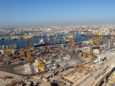
The Port of Dakar is at the crossroad between Europe, North America, South America and West Sub-Saharan Africa. It is located on the westernmost coast of Africa, built on a natural crew reef and well protected from Atlantic swell. The port has been opened to commercial traffic since 1865. It provides excellent shelter to ships, and ensures safe access at all times: the highest tides vary between 0.20 and 1.80 metres.
Dakar has one of the largest deep-water seaports along the West African coast. It ranks fifth in cargo volume after Richards-Bay, Durban, Lagos and Abidjan. The Senegalese government has established an independent entity to manage the port, namely the Société Nationale du Port Autonome de Dakar (SN-PAD) or Dakar Port Authority.
The total length of the piers is about 10 km for 40 available berths. The draught is between 10 and 13 meters. The Dakar Port also got a new Logistic Platform to improve their activities. The platform cover 21 hectares, there is 40 000 m2 of Warehouses, 750 parking places for trucks. The platform regroups also the offices of freight forwarders, customs, wholesalers etc. For now the platform is not totally operational.
For additional information on the Port of Dakar, please see the following link: Website for Port of Dakar
|
Port Location and Contacts |
|
|---|---|
|
Country |
Senegal |
|
Province or District |
Dakar |
|
Town or City (Closest location) with Distance (km) |
Name : Dakar km: n/a |
|
Port's Complete Name |
Port of Dakar |
|
Latitude |
14.68222 |
|
Longitude |
-17.43 |
|
Managing Company or Port Authority (If more than one operator, break down by area of operation) |
Port Autonome de Dakar |
|
Management Contact Person |
Cheikh Kante |
|
Closest Airport and Frequent Airlines to / from International Destinations |
Airport Name: n/a Airlines: n/a |
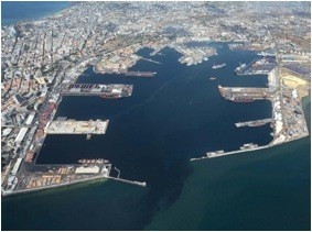
Port Picture
Description and Contacts of Key Companies
For port company contact details, please see the following link: 4.3 Senegal Port and Waterways Company Contact List
For additional port contact details, please see the following website: Website of Dakar Port Authority
Port Performance
The Port of Dakar was visited by 2858 vessels in 2012. In 2012, the Port of Dakar handled a total of 11 869 557 tons of cargo. The structure of the global traffic goes like this: 60% for importations, 16% of the cargo for exportation, the transit cargo represent 15%, transhipment 6% and fishing represent 3%. Cargo transit to Mali represents 90% of the global transit. In 2012 the traffic to Mali increases of 14%. In 2012, the Port of Dakar handled close to 50 thousand vehicles. Information on Seasonal Constraints not provided
|
Handling Figures |
Year 2012 |
|---|---|
|
Vessel Calls |
2858 |
|
Container Traffic (TEUs) |
3276 |
|
Handling Figures Bulk and Break Bulk |
Year 2012 |
|---|---|
|
Bulk (MT) & Break bulk (MT) |
*See below |
|
Total Cargo Handling (MT) |
11 869 557 |
| Total Annual Capacity of the Port | 12 026 000 |
* Bulk and Break Bulk Handling Figures unavaliable however, additional information has been taken from the old LCA and added to suit the new format
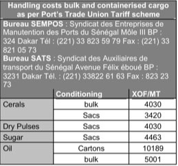
Discharge Rates and Terminal Handling Charges
For discharge rates and port costs, please see the following tables:
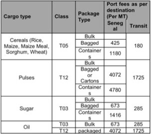
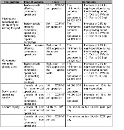
For additional details on discharge rates and terminal handling charges, please see the following link: Website of Port Charges and Invoicing of Dakar Port Authority
General Cargo Handling Berths
For additional information on the Port of Dakar, please see the following link: Additional Port of Dakar Information
Note: The information provided in the attached document, which has been taken from the old LCA, does not match the structure of the new LCA and is therefore provided separately.
Port Handling Equipment
Hire of labor is generally arranged by labor companies/unions such as SATS, BMO accredited by the PAD and who have their own tariff protocols with companies working in the port. Hire of equipment is mainly governed by the SEMPOS tariff that is applied by most stevedoring companies in the port.
|
Equipment |
Available (Yes / No) |
Total Quantity and Capacity Available |
Comments on Current Condition and Actual Usage |
|---|---|---|---|
|
Dockside Crane |
n/a |
n/a |
n/a |
|
Container Gantries |
Yes |
4 available, 39.5 T capacity |
Safe working Lift under spreader |
|
Mobile Cranes |
Yes |
3 available, 100T capacity |
- |
|
Reachstacker |
Yes | 14 avalaible | - |
|
RoRo Tugmaster (w/ Trailer) |
n/a |
n/a |
n/a |
|
Grain Elevator w/ Bagging Machines |
n/a |
n/a |
n/a |
|
Transtrainer |
n/a |
n/a |
n/a |
|
Forklifts |
Yes |
30 available |
- |
| Empty Handlers | Yes | 4 | - |
Container Facilities
|
Facilities |
20 ft |
40 ft |
|---|---|---|
|
Container Facilities Available |
Yes |
Yes
|
|
Container Freight Station (CFS) |
4 |
n/a |
|
Refrigerated Container Stations |
1 |
1 |
|
Other Capacity Details |
||
|
Daily Take Off Capacity (Containers per day) |
900 |
|
|
Number of Reefer Stations (connection points) |
448 |
|
|
Emergency Take-off Capacity (Give an indication) |
200 |
|
|
Off take capacity of gang shift (in Containers per shift) |
n/a |
n/a |
Customs Guidance
For information on customs guidance, please see section 1.3 Customs Information & 1.4 Shipping Information:
1.3 Senegal Customs Information
Terminal Information
Multipurpose Terminal
The Container Terminal in not directly managed by the Governmental Port Authority “Port Autonome de Dakar” but is assigned to private Companies. Since January 2008, the container terminal is managed by Dubai Port World. The Container Terminal situated in the Northern Zone of Dakar Port covers an area of 24 ha and approx.700 meters of linear quay with three (03) berths dredged from 12 to 13 m. An up-to-date equipment is available for handling services including four (04) wharf gantry cranes (two of which Post-Panamax), four (04) Gottwald cranes on tyres, ten (10) yard gantry cranes, fifteen (15) reach stackers, four hundred (400) plugs and sockets for reefer containers. The annual traffic of around 300 000 TEUs, in constantly growing.
Multipurpose Terminal
For additional information on terminals, please see attached document: Senegal Port of Dakar additional Information
Note: The information provided in the attached document, which has been taken from the old DLCA, does not match the structure of the new LCA and is therefore provided separately.
Main Storage Terminal
Storage facilities managed by Port Authonome de Dakar.
For additional information on storage, please see attached document: Senegal Port of Dakar additional Information
Note: The information provided in the attached document, which has been taken from the old DLCA, does not match the structure of the new LCA and is therefore provided separately.
Stevedoring
Handling operations aboard ships, lifting in storage areas and on the quays, stuffing and shipping of containers and delivery are provided by private companies. The handling equipment is constantly renewed to ensure an efficient service for all categories of cargo and types of ships. It consists of cranes and elevators (reach stackers, front-loaders). The new operator DP World has considerably extended the equipment of the Port of Dakar with four quay cranes (2 panamax and 2 post-panamax) and 10 gantry cranes RTG.
Port Security
Having quickly understood the new security issues in the environment of the international maritime transports, the port committed itself in a vast program of tremendous changes.
With the ISPS code (International Ship and Port facilities Code) coming into force, the Port of Dakar had taken all financial and material steps to make the port installations and operations comply with the directives resulting from the SOLAS (Surf ace Ocean Lower Atmosphere Study) instructions.
For that reason, the Port developed a series of devices:
- An aid to navigation device located at the port control (Vigie) and equipped with an AIS (Automatical Identification of Ships) system and a functional beaconing system.
- A waterplan and roads watch system equipped with radars, remote watch systems and nautical patrols
- A device to secure port access and premises with the development the first polyvalent aid centre equipped with high technology units.
|
Security |
||
|---|---|---|
|
ISPS Compliant (Yes / No) |
Yes |
|
|
Current ISPS Level |
1 |
Level 1 = Normal, Level 2 = Heightened, Level 3 = Exceptional |
|
Police Boats |
n/a |
|
|
Fire Engines |
n/a |
2.2 Senegal Aviation
Senegal Aviation

Key airport information may also be found at: http://worldaerodata.com/
Senegal has 20 airports of which 9 have paved runways and 11 unpaved runways. Dakar is the main airport of the country with international standards. 190 kilometres from Dakar, is the Kaolack Airfield, which is primarily used as disengagement airfield for Dakar Airport. Other Senegalese airports are Tambacounda, Ziguinchor, Saint-Louis and Cap-Skirring. The security of the navigation in was ensured in by ASECNA (The Agency for the Security of Air Navigation in Africa and Madagascar), but since may 2008 the control is back to the Senegalese Government through the “Agence Nationale de l'Aviation Civile du Sénégal”. The HQ of the ASECNA is hosted in Senegal, but following Senegal’s exit from the organisation, it could be moved in another country.
For information on government contacts, please see the following link: 4.1 Senegal Government Contact List
For information on airport company contact details, please see the following link: 4.4 Senegal Airport Company Contact List
Procedures for Foreign Registered Aircraft
An aircraft can not operate on the territory of the Republic of Senegal unless it is registered. Except in cases where authorization is granted by ANACS, no person shall operate an aircraft in Senegal unless it is registered in Senegal, in a contracting state or in a foreign state that has concluded with Senegal an agreement for use in Senegal of an aircraft registered in that State. It is prohibited to use civil aircraft to be eligible for registration under the laws of Senegal unless it is registered by its owner under the provisions of the laws of the Authority and Senegal (ANACS) has issued a certificate registration for that aircraft. The registration certificate must be kept permanently on board the aircraft.
REGISTRATION ELIGIBILITY
An aircraft is eligible for
registration if: The aircraft is owned by a Senegalese
citizen, a foreign citizen residing in Senegal elected, a body
incorporated under the laws of Senegal or a government agency in
Senegal;
The aircraft is not registered
in a foreign state.
APPLICATION FOR REGISTRATION
Any person wishing to register an aircraft in Senegal must file an application or petition to ANACS accordance with standards and procedures defined by this regulation. Any application:
- must contain information concerning the identity of the applicant;
- provide proof of ownership;
- must be signed in indelible ink;
Taxes and fees prescribed by law shall be paid to the ANACS at the filing of the application for registration. If the applicant meets all the requirements for registration, ANACS must issue a certificate of registration
2.2.1 Senegal Léopold Sédar Senghor International Airport
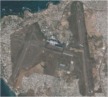
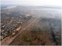
Léopold Sédar Senghor International Airport is an international airport serving Dakar, the capital of Senegal. The airport is situated near the town of Yoff, north of Dakar. It was known as Dakar Yoff International Airport(French: Aéroport International de Dakar Yoff) until 9 October 1996, when it was renamed in honor of Léopold Sédar Senghor, the first president of Senegal. The airport can handle aircraft up to the size of the Boeing 747 jets. In 2010, the airport served about 2,300,000 passengers.
Several international companies serviced the Dakar : Air France, South African, Royal Air Maroc, Kenya Airways, Delta, Afrikiyah, TAP, SN Brussels etc. Dakar is so directly connected to north, south and eastern African countries, to European main cities and is probably one of only sub-Saharian city connected to the USA. It worth mention the fact that a part of the airport is used by the French Air Force, this military part of the airport is also occasionally used by UN flights. There is a new international airport construction ongoing. The International Airport of Blaise Diagne in Diass works are 65% done and the project should be ready by the end of 2014.
| Location Details | |||
|---|---|---|---|
| Country | Senegal | Latitude | 14.74389 |
| Province / District | Dakar | Longitude | -17.47944 |
| Town or City (Closest) | Dakar | Elevation (ft and m) | 85 ft / 26 m |
| Airfield Name | Léopold Sédar Senghor International Airport | IATA and ICAO Codes | DKR - GOOY |
| Open From (hours) | 00:00 | Open To (hours) | 24:00 |
Runways
Leopold Sedar Senghor International Airport, located in Dakar-Yoff has 2 runways, of which the longest is 11450 feet (3490 metres) long.
|
Runway #1 |
|
|---|---|
|
Runway Dimensions |
3940m x 45m
|
|
Orientation |
14°45’27,09” N / 017°28’51,43” W |
|
Surface |
Asphalt |
|
Runway #2 |
|
|---|---|
|
Runway Dimensions |
1500m x 30m |
|
Orientation |
14°43’55,86” N / 017°30’16,02” W |
|
Surface |
Asphalt |
Helicopter Pad(s)
|
Helipad #1 |
|
|---|---|
|
Present (Yes / No) |
Yes |
|
Largest helicopter that can land |
MI26 |
|
Width and Length (metres) |
n/a |
|
Surface |
Asphalt |
Airport Infrastructure Details
Located on the plain of Yoff, Dakar airport covers an area of 800 hectares, bounded by a fence of 16 km long. The terminal building is equiped with 14 short term parking spaces, 5 long term parking spaces, Bureau de Change, Restaurants, Cafeterias, Duty Free Shop, Tourist Help Desk, Car Rental, Taxi Service/Rank.
|
Customs |
Yes |
JET A-1 fuel |
Yes |
|---|---|---|---|
|
Immigration |
Yes |
AVGAS 100 |
Yes |
|
Terminal Building |
Yes |
Single Point Refueling |
Yes |
|
Passenger Terminal |
Yes |
Air Starter Units |
Yes |
|
Cargo terminal |
Yes |
Ground Power (mobile) |
Yes |
|
Pax transport to airfield |
Yes |
Ground Handling Services |
Yes |
|
Control Tower |
Yes |
Latrine Servicing |
Yes |
|
Weather Facilities |
Yes |
Fire Fighting Category (ICAO) |
Yes |
|
Catering Services |
Yes |
De-icing Equipment |
- |
|
Base Operating Room |
Yes |
Parking Ramp Lighting |
Yes |
|
Airport Radar |
Yes |
Approach & Runway Lights |
Yes |
|
NDB |
Yes |
VOR |
Yes |
|
ILS |
Yes |
|
Passenger and Cargo Performance Indicator
|
Performance for 2013 |
Annual Figures |
Monthly | Daily |
|---|---|---|---|
|
Total aircraft movements |
35,000 |
2917 | 96 |
|
Total passengers |
2,200,000 |
183,333 | 6023 |
|
Total capacity of the airport (metric tonnes) |
36,000 MT |
3000 | 99 |
|
Current activity of the airport (metric tonnes) |
24,000 MT |
2000 | 66 |
|
Current use by Humanitarian flights (UNHAS) |
n/a | n/a | n/a |
*Monthly and daily performance figures derived from annual figures provided on 21st March 2013
Airport Operating Details
| Operating Details | |||
|---|---|---|---|
| Maximum sized aircraft which can be offloaded on bulk cargo: | Boeing 747/Antonov 124 | ||
| Maximum sized aircraft that can be offloaded on pallet | Boeing 747/Antonov 124 | ||
| Total aircraft parking area (m²) | n/a | ||
| Storage Area (mt) | 6410 | Cubic Meters (m³) | n/a |
| Cargo Handling Equipment Available (Yes / No) | Yes | If "Yes" specify below | |
| Elevators / Hi Loaders (Yes / No) | Yes | Max Capacity (mt) | n/a |
| Can elevators / hi loaders reach the upper level of a B747 (Yes / No) | Yes | ||
| Loading Ramps (Yes / No) | Yes | ||
Storage Facilities
Airport storage space is rent by the Airport Authority to Handling and Freight companies as DHL or Air France Cargo. This space is limited as used only to store merchandises before loading or just after unloading the plane prior to forward the stock by road.
Airfield Cost
Navigation Charges
Navigation charges unavailable
For additional charges information please see the attached document: Senegal Léopold Sédar Senghor International Airport Additional Information
Note: The information provided in the attached document, which has been taken from the old DLCA, does not match the structure of the new LCA and is therefore provided separately.
Taxes are due to the Airport Authority. In case of Humanitarian flights, those fees can be probably be negotiated to obtain a reduction or even an exemption.
For additional information on taxes, please see the following link: Website for additional airport & tax Information
Fuel Services Charges
| Price per Litre ** | Minimum Quantity (Litres) |
|---|---|
|
480 XOF with Taxes 375 XOF Tax Free |
1000 |
'Note: The information provided has been taken from the old DLCA and adjusted to suit the structure of the new LCA
** *Charges as of Dec 2010
Cargo Terminal Charges
At Dakar’s Léopold Sédar Senghor International Airport there are two agreed specialized handling service companies that share the airport traffic service:
Sénégal Handling Services S.A. and Aviation Handling Services, both meet international quality standards, work 24/7 and are able to handle any plane until Antonov 124.
For details on charges and services provided by Sénégal Handling Services S.A. and Aviation Handling Services, please see the following document: Senegal Léopold Sédar Senghor International Airport Additional Information
Air-bridge Charges
Information on Air-bridge Charges unavailable
Security
Level: Good
Companies Available
For details on airport company contacts, please see the following link: 4.4 Senegal Airport Company Contact List
Information on some aviation service providers can be found at: http://www.azfreight.com/
2.2.2 Senegal Kaolack Airfield
|
Airport Details |
|||
|---|---|---|---|
|
Country |
Senegal |
Latitude |
14.14667 |
|
Province / District |
Kaolack |
Longitude |
-16.05111 |
|
Airport Name |
Kaolack Airport |
Elevation (ft) |
26 ft |
|
IATA & ICAO codes |
KLC/GOOK |
Surface |
Asphalt |
|
Town or City (closest) |
Kaolack |
Runway Condition |
damaged |
|
NGO / UN (on ground) |
n/a |
Passenger / Cargo Security Screening (Yes / No) |
n/a |
|
Runway Dimension |
1600m x 29m |
Ground Handling (Yes / No) |
n/a |
|
Refueling Capacity |
n/a |
Runway Lighting (Yes / No) |
n/a |
|
Runway Heading |
n/a |
Fire Fighting Equipment (Yes / No) |
n/a |
|
Air Traffic Control (Yes / No) |
n/a |
Windsock (Yes / No) |
n/a |
|
Weather Information (Yes / No) |
n/a |
Aircraft Parking space (Yes / No) |
n/a |
|
Navigation Aids (Yes / No) |
n/a |
Perimeter fencing (Yes / No) |
n/a |
2.2.3 Senegal Tambacounda Airport
|
Airport Details |
|||
|---|---|---|---|
|
Country |
Senegal |
Latitude |
13.73667 |
|
Province / District |
Tambacounda |
Longitude |
-13.65306 |
|
Airport Name |
Tambacounda |
Elevation (ft) |
161 ft |
|
IATA & ICAO codes |
TUD / GOTT |
Surface |
Asphalt |
|
Town or City (closest) |
Tambacounda |
Runway Condition |
Good |
|
NGO / UN (on ground) |
n/a |
Passenger / Cargo Security Screening (Yes / No) |
n/a |
|
Runway Dimension |
2000m x 29m |
Ground Handling (Yes / No) |
n/a |
|
Refueling Capacity |
n/a |
Runway Lighting (Yes / No) |
n/a |
|
Runway Heading |
06 / 24 |
Fire Fighting Equipment (Yes / No) |
n/a |
|
Air Traffic Control (Yes / No) |
n/a |
Windsock (Yes / No) |
n/a |
|
Weather Information (Yes / No) |
n/a |
Aircraft Parking space (Yes / No) |
m/a |
|
Navigation Aids (Yes / No) |
n/a |
Perimeter fencing (Yes / No) |
n/a |
2.2.4 Senegal Ziguinchor Airport
|
Airport Details |
|||
|---|---|---|---|
|
Country |
Senegal |
Latitude |
12.55556 |
|
Province / District |
Basse Casamance |
Longitude |
-16.28167 |
|
Airport Name |
Ziguinchor Airport |
Elevation (ft) |
75 |
|
IATA & ICAO codes |
ZIG/GOGG |
Surface |
Asphalt |
|
Town or City (closest) |
Ziguinchor |
Runway Condition |
Good |
|
NGO / UN (on ground) |
n/a |
Passenger / Cargo Security Screening (Yes / No) |
n/a |
|
Runway Dimension |
1545m x 29m |
Ground Handling (Yes / No) |
n/a |
|
Refueling Capacity |
n/a |
Runway Lighting (Yes / No) |
n/a |
|
Runway Heading |
n/a |
Fire Fighting Equipment (Yes / No) |
n/a |
|
Air Traffic Control (Yes / No) |
n/a |
Windsock (Yes / No) |
n/a |
|
Weather Information (Yes / No) |
n/a |
Aircraft Parking space (Yes / No) |
n/a |
|
Navigation Aids (Yes / No) |
n/a |
Perimeter fencing (Yes / No) |
n/a |
2.2.5 Senegal Bakel Airport
|
Airport Details |
|||
|---|---|---|---|
|
Country |
Senegal |
Latitude |
14.84722 |
|
Province / District |
Tambacounda |
Longitude |
-12.46806 |
|
Airport Name |
Bakel Airport |
Elevation (ft) |
98 |
|
IATA & ICAO codes |
BXE/GOTB |
Surface |
Macadam |
|
Town or City (closest) |
Bakel |
Runway Condition |
Good |
|
NGO / UN (on ground) |
n/a |
Passenger / Cargo Security Screening (Yes / No) |
n/a |
|
Runway Dimension |
1750m x 29m |
Ground Handling (Yes / No) |
n/a |
|
Refueling Capacity |
n/a |
Runway Lighting (Yes / No) |
n/a |
|
Runway Heading |
n/a |
Fire Fighting Equipment (Yes / No) |
n/a |
|
Air Traffic Control (Yes / No) |
n/a |
Windsock (Yes / No) |
n/a |
|
Weather Information (Yes / No) |
n/a |
Aircraft Parking space (Yes / No) |
n/a |
|
Navigation Aids (Yes / No) |
n/a |
Perimeter fencing (Yes / No) |
n/a |
2.2.6 Senegal Cap Skiring Airport
|
Airport Details |
|||
|---|---|---|---|
|
Country |
Senegal |
Latitude |
12.39361 |
|
Province / District |
Cap Skiring |
Longitude |
-16.74639 |
|
Airport Name |
Cap Skiring Airport |
Elevation (ft) |
52 |
|
IATA & ICAO codes |
CSK/GOGS |
Surface |
Concrete |
|
Town or City (closest) |
Cap Skiring |
Runway Condition |
Good |
|
NGO / UN (on ground) |
n/a |
Passenger / Cargo Security Screening (Yes / No) |
n/a |
|
Runway Dimension |
1433m x 29m |
Ground Handling (Yes / No) |
n/a |
|
Refueling Capacity |
n/a |
Runway Lighting (Yes / No) |
n/a |
|
Runway Heading |
n/a |
Fire Fighting Equipment (Yes / No) |
n/a |
|
Air Traffic Control (Yes / No) |
n/a |
Windsock (Yes / No) |
n/a |
|
Weather Information (Yes / No) |
n/a |
Aircraft Parking space (Yes / No) |
n/a |
|
Navigation Aids (Yes / No) |
n/a |
Perimeter fencing (Yes / No) |
n/a |
2.2.7 Senegal Saint Louis Airport
|
Airport Details |
|||
|---|---|---|---|
|
Country |
Senegal |
Latitude |
16.05083 |
|
Province / District |
Saint Louis |
Longitude |
-16.46306 |
|
Airport Name |
Saint Louis Airport |
Elevation (ft) |
9 |
|
IATA & ICAO codes |
XLS/GOSS |
Surface |
Asphalt |
|
Town or City (closest) |
Saint Louis |
Runway Condition |
Good |
|
NGO / UN (on ground) |
n/a |
Passenger / Cargo Security Screening (Yes / No) |
n/a |
|
Runway Dimension |
1899m x 45m |
Ground Handling (Yes / No) |
n/a |
|
Refueling Capacity |
n/a |
Runway Lighting (Yes / No) |
n/a |
|
Runway Heading |
n/a |
Fire Fighting Equipment (Yes / No) |
n/a |
|
Air Traffic Control (Yes / No) |
n/a |
Windsock (Yes / No) |
n/a |
|
Weather Information (Yes / No) |
n/a |
Aircraft Parking space (Yes / No) |
n/a |
|
Navigation Aids (Yes / No) |
n/a |
Perimeter fencing (Yes / No) |
n/a |
2.2.8 Senegal Kolda North Airport

|
Airport Details |
|||
|---|---|---|---|
|
Country |
Senegal |
Latitude |
12.89833 |
|
Province / District |
Haute Casamance |
Longitude |
-14.96806 |
|
Airport Name |
Kolda North Airport |
Elevation (ft) |
33 |
|
IATA & ICAO codes |
KDA/GOGK |
Surface |
Asphalt |
|
Town or City (closest) |
Kolda |
Runway Condition |
Good |
|
NGO / UN (on ground) |
n/a |
Passenger / Cargo Security Screening (Yes / No) |
n/a |
|
Runway Dimension |
1502m x 15m |
Ground Handling (Yes / No) |
n/a |
|
Refueling Capacity |
n/a |
Runway Lighting (Yes / No) |
n/a |
|
Runway Heading |
n/a |
Fire Fighting Equipment (Yes / No) |
n/a |
|
Air Traffic Control (Yes / No) |
n/a |
Windsock (Yes / No) |
n/a |
|
Weather Information (Yes / No) |
n/a |
Aircraft Parking space (Yes / No) |
n/a |
|
Navigation Aids (Yes / No) |
n/a |
Perimeter fencing (Yes / No) |
n/a |
2.2.9 Senegal Matam Airport
|
Airport Details |
|||
|---|---|---|---|
|
Country |
Senegal |
Latitude |
15.59389 |
|
Province / District |
Matam |
Longitude |
-13.32222 |
|
Airport Name |
Matam/Orousogui |
Elevation (m) |
26 m |
|
IATA & ICAO codes |
GOSM |
Surface |
granular laterite |
|
Town or City (closest) |
Matam |
Runway Condition |
ok, to be careful during rainy season |
|
NGO / UN (on ground) |
n/a |
Passenger / Cargo Security Screening (Yes / No) |
n/a |
|
Runway Dimension |
1700m x 30m |
Ground Handling (Yes / No) |
n/a |
|
Refueling Capacity |
n/a |
Runway Lighting (Yes / No) |
n/a |
|
Runway Heading |
n/a |
Fire Fighting Equipment (Yes / No) |
n/a |
|
Air Traffic Control (Yes / No) |
n/a |
Windsock (Yes / No) |
n/a |
|
Weather Information (Yes / No) |
n/a |
Aircraft Parking space (Yes / No) |
n/a |
|
Navigation Aids (Yes / No) |
n/a |
Perimeter fencing (Yes / No) |
n/a |
2.2.10 Senegal Podor Airport
|
Airport Details |
|||
|---|---|---|---|
|
Country |
Senegal |
Latitude |
16.68333 |
|
Province / District |
St-Louis |
Longitude |
-14.96667 |
|
Airport Name |
Podor Airport |
Elevation (m) |
6 m |
|
IATA & ICAO codes |
GOSP |
Surface |
Laterite |
|
Town or City (closest) |
Podor |
Runway Condition |
ok |
|
NGO / UN (on ground) |
n/a |
Passenger / Cargo Security Screening (Yes / No) |
n/a |
|
Runway Dimension |
1550m x 30m |
Ground Handling (Yes / No) |
n/a |
|
Refueling Capacity |
n/a |
Runway Lighting (Yes / No) |
n/a |
|
Runway Heading |
n/a |
Fire Fighting Equipment (Yes / No) |
n/a |
|
Air Traffic Control (Yes / No) |
n/a |
Windsock (Yes / No) |
n/a |
|
Weather Information (Yes / No) |
n/a |
Aircraft Parking space (Yes / No) |
n/a |
|
Navigation Aids (Yes / No) |
n/a |
Perimeter fencing (Yes / No) |
n/a |
2.2.11 Senegal Linguere Airport
|
Airport Details |
|||
|---|---|---|---|
|
Country |
Senegal |
Latitude |
15.4 |
|
Province / District |
Louga |
Longitude |
-15.08389 |
|
Airport Name |
Linguère Airport |
Elevation (m) |
19.6 m |
|
IATA & ICAO codes |
GOOG |
Surface |
Granular Laterite |
|
Town or City (closest) |
Linguère |
Runway Condition |
ok |
|
NGO / UN (on ground) |
n/a |
Passenger / Cargo Security Screening (Yes / No) |
n/a |
|
Runway Dimension |
1390m x 30m |
Ground Handling (Yes / No) |
n/a |
|
Refueling Capacity |
n/a |
Runway Lighting (Yes / No) |
n/a |
|
Runway Heading |
n/a |
Fire Fighting Equipment (Yes / No) |
n/a |
|
Air Traffic Control (Yes / No) |
n/a |
Windsock (Yes / No) |
n/a |
|
Weather Information (Yes / No) |
n/a |
Aircraft Parking space (Yes / No) |
n/a |
|
Navigation Aids (Yes / No) |
n/a |
Perimeter fencing (Yes / No) |
n/a |
2.2.12 Senegal Richard Toll Airport
|
Airport Details |
|||
|---|---|---|---|
|
Country |
Senegal |
Latitude |
16.43333 |
|
Province / District |
St-Louis |
Longitude |
-15.65 |
|
Airport Name |
Richard Toll Airport |
Elevation (ft) |
6m |
|
IATA & ICAO codes |
GOSR |
Surface |
Laterite |
|
Town or City (closest) |
Richard Toll |
Runway Condition |
ok |
|
NGO / UN (on ground) |
n/a |
Passenger / Cargo Security Screening (Yes / No) |
n/a |
|
Runway Dimension |
1550m x 30m |
Ground Handling (Yes / No) |
n/a |
|
Refueling Capacity |
n/a |
Runway Lighting (Yes / No) |
n/a |
|
Runway Heading |
n/a |
Fire Fighting Equipment (Yes / No) |
n/a |
|
Air Traffic Control (Yes / No) |
n/a |
Windsock (Yes / No) |
n/a |
|
Weather Information (Yes / No) |
n/a |
Aircraft Parking space (Yes / No) |
n/a |
|
Navigation Aids (Yes / No) |
n/a |
Perimeter fencing (Yes / No) |
n/a |
2.2.13 Senegal Simenti Airport
|
Airport Details |
|||
|---|---|---|---|
|
Country |
Senegal |
Latitude |
13.05 |
|
Province / District |
Tambacounda |
Longitude |
-13.3 |
|
Airport Name |
Simenti Airport |
Elevation (m) |
48 m |
|
IATA & ICAO codes |
GOTS |
Surface |
laterite |
|
Town or City (closest) |
Simenti |
Runway Condition |
ok air field open from 15/12 to 15/05 |
|
NGO / UN (on ground) |
n/a |
Passenger / Cargo Security Screening (Yes / No) |
n/a |
|
Runway Dimension |
1800m x 30 |
Ground Handling (Yes / No) |
n/a |
|
Refueling Capacity |
n/a |
Runway Lighting (Yes / No) |
n/a |
|
Runway Heading |
n/a |
Fire Fighting Equipment (Yes / No) |
n/a |
|
Air Traffic Control (Yes / No) |
n/a |
Windsock (Yes / No) |
n/a |
|
Weather Information (Yes / No) |
n/a |
Aircraft Parking space (Yes / No) |
n/a |
|
Navigation Aids (Yes / No) |
n/a |
Perimeter fencing (Yes / No) |
n/a |
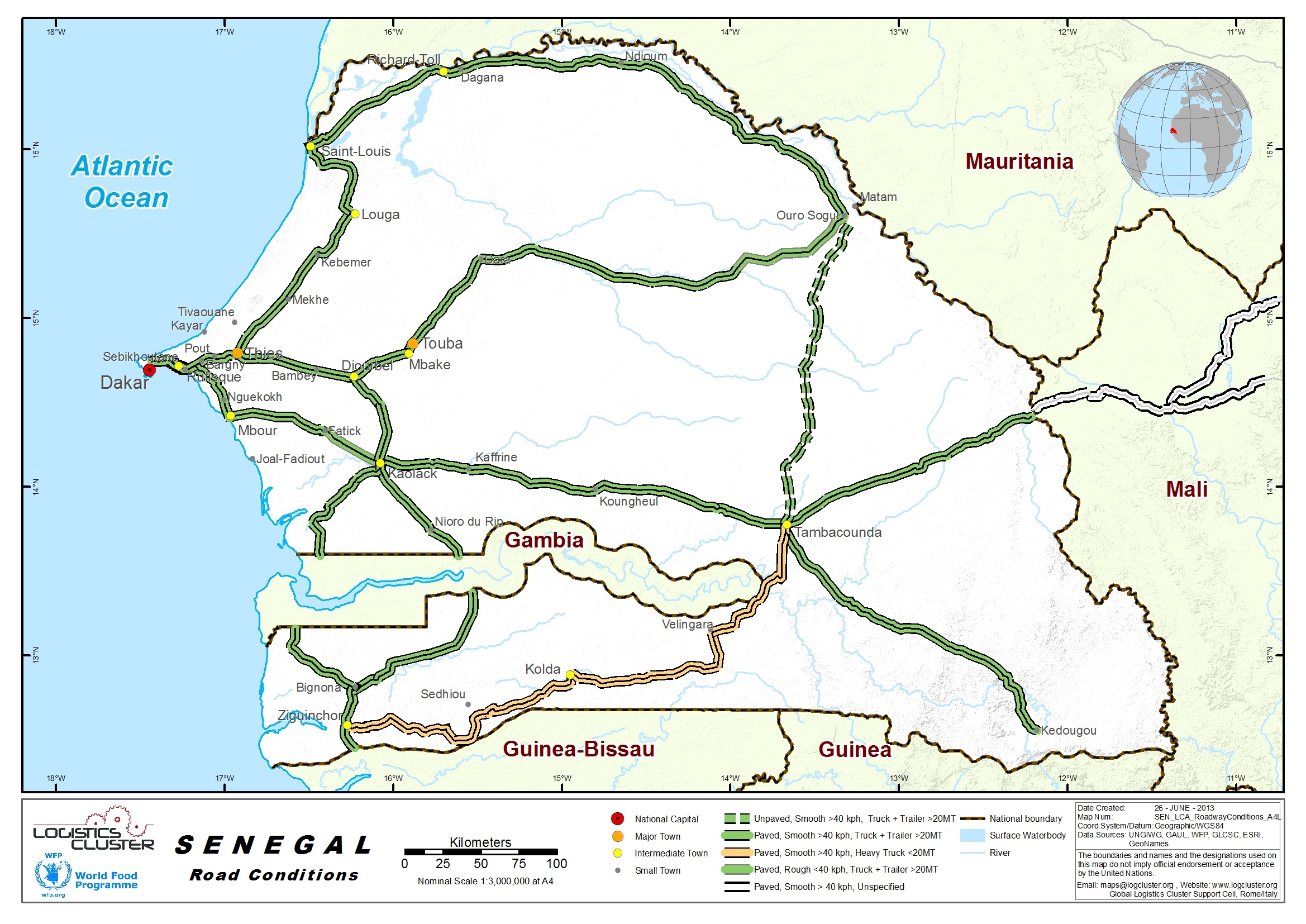
2.3 Senegal Road Assessment
Senegal Road Network

About 90% of movements of people and goods in Senegal are made via roads. The roads network is estimated at about 14,500 km, of which 4,500 km are paved. In fact, it is now possible from Dakar to reach any of the other ten Senegalese main regional cities by paved road. The Government of Senegal has launched an ambitious programme aimed at rehabilitating certain roads and building new ones. However, as in many other African countries, road maintenance is a recurrent problem.
For Senegal government contacts, please see the following link: 4.1 Senegal Government Contact List
Distance Matrix
| Dakar | Thies | Kaolack | Tambacounda | Kedougou | Kolda | Veligara | Ziguinchor | St-Louis | Matam | Diourbel | |
|---|---|---|---|---|---|---|---|---|---|---|---|
| Dakar | 0 | 70 | 189 | 462 | 695 | 461 | 565 | 451 | 266 | 525 | 146 |
| Thies | 70 | 0 | 140 | 413 | 646 | 412 | 516 | 402 | 196 | 455 | 76 |
| Kaolack | 189 | 140 | 0 | 273 | 506 | 272 | 376 | 251 | 271 | 443 | 64 |
| Tambacounda | 462 | 413 | 273 | 0 | 233 | 226 | 103 | 414 | 544 | 384 | 337 |
| Kedougou | 695 | 646 | 506 | 233 | 0 | 459 | 336 | 647 | 777 | 617 | 570 |
| Kolda | 461 | 412 | 272 | 226 | 459 | 0 | 123 | 188 | 543 | 610 | 336 |
| Velingara | 565 | 516 | 376 | 103 | 336 | 123 | 0 | 311 | 712 | 487 | 440 |
| Ziguinchor | 451 | 402 | 251 | 414 | 647 | 188 | 311 | 0 | 533 | 798 | 326 |
| St-Louis | 266 | 196 | 271 | 544 | 777 | 543 | 712 | 533 | 0 | 412 | 207 |
| Matam | 525 | 455 | 443 | 384 | 617 | 610 | 487 | 798 | 412 | 0 | 379 |
| Diourbel | 146 | 76 | 64 | 337 | 570 | 336 | 440 | 326 | 207 | 379 | 0 |
Travel Time Matrix
|
Dakar |
Thies | Kaolack | Tambacounda | Kedougou | Kolda | Velingara | Ziguinchor | St-Louis | Matam | Diourbel | |
|---|---|---|---|---|---|---|---|---|---|---|---|
| Dakar | 0 | 1h45 | 4h | 7h30 | 10h30 | 13h00 | 10h00 | 16h45 | 3h40 | 9h20 | 3h00 |
| Thies | 1h45 | 0 | 2h15 | 5h30 | 8h30 | 11h45 | 9h00 | 14h45 | 2h00 | 7h45 | 1h15 |
| Kaolack | 4h00 | 2h15 | 0 | 4h00 | 6h45 | 9h15 | 6h15 | 12h10 | 4h30 | 6h00 | 1h30 |
| Tambacounda | 7h30 | 5h30 | 4h00 | 0 | 3h15 | 5h30 | 2h30 | 9h15 | 8h00 | 7h00 | 4h45 |
| Kedougou | 10h30 | 8h30 | 6h45 | 3h15 | 0 | 7h30 | 4h30 | 11h15 | 11h00 | 7h00 | 7h30 |
| Kolda | 13h00 | 11h45 | 9h30 | 5h30 | 7h30 | 0 | 3h00 | 3h45 | 11h00 | 6h30 |
7h30
|
| Velingara | 10h00 | 9h00 | 6h15 | 2h30 | 4h30 | 3h00 | 0 | 6h45 | 9h15 | 4h00 | 6h00 |
| Ziguinchor | 16h45 | 14h45 | 12h10 | 9h15 | 9h45 | 3h45 | 6h45 | 0 | 9h45 | 9h00 | 6h00 |
| St-Louis | 3h40 | 2h00 | 4h30 | 8h00 | 11h00 | 11h00 | 9h15 | 9h45 | 0 | 5h30 | 3h45 |
| Matam | 9h20 | 7h45 | 6h00 | 7h00 | 7h00 | 6h30 | 4h00 | 9h00 | 5h30 | 0 | 7h30 |
| Diourbel | 3h00 | 1h15 | 1h30 | 4h45 | 7h30 | 7h30 | 6h00 | 6h00 | 3h45 | 7h30 | 0 |
Road Security
Security Level: Good
No security problems in general but for the Cassamance region. There, some road segments are not authorised for usage by UN staff due to the presence of active rebel groups. So in Cassamance, it is better to avoid segment of road N5 from Séléti to Bignona and N4 from Ziguinchor to Sao Domingos in Guinee Bissau. See UNDSS for more information if you plan to travel in the region. Drivers tend to exceed speed limits, follow other vehicles closely, ignore lane markings, and attempt to pass even when facing oncoming traffic.
Some roads have sidewalks or sufficient space for pedestrian traffic, others do not, and pedestrians are forced to walk in or along the roadway. Due to limited street lighting, pedestrians are difficult to see at night. Drivers in both rural and urban areas may frequently expect to encounter and share the road with motorcycles, bicyclists, pedestrians, livestock and animal carts. Caution and defensive driving techniques are strongly recommended. During the rainy season, many roads, mostly regional roads, departmental roads and tracks are passable only with four-wheel drive vehicles and so places are just not accessible at all.
Weighbridges and Axle Load Limits
As the majority of heavy vehicle traffic in Senegal has its origin and destination in Dakar, and more specifically the Port of Dakar, an effective way to control overloading would be to weigh all heavy vehicles leaving and entering the Port of Dakar. It was therefore recommended that negotiations be entered into with the Port Authority to establish weighbridges at the main entrances to the port.
These weighbridges would be used for overload law enforcement and should comply with all the requirements in terms of facilities, equipment, type of scale, computer equipment, software, and holding facilities. The existing weighbridge at one of the port entrances, which is currently used for commercial purposes, could be upgraded to a multi-deck scale and be used for law enforcement in addition to its current function. However, the logistics of the weighing activities would have to be analysed to ensure that undue delays are not caused.
There is an ongoing project of the State to build 6 fixed weighbridges stations in the country, Diamniodio, Tanabcounda, Thies, Kidira and Rosso. The works has to be done by 2014. For now there is 3 mobile weighbridges installed around the country, one at Dakar Port, one in Tambacounda and one in Diamniodio. Senegal Government revised the axle load limit in line with the ECOWAS specifications but there are not enough weighbridges in the country, hence vehicles still exceed allowable limits. The maximum axle load restriction applicable in the ECOWAS Region is 11.5 tons. Sanctions are applicable by the regulation 14-2005/UEMOA , in case of transgression of the authorized limits. But so far, the government doesn't have the means to control all the traffic.
|
Axle load limits |
LCA Country |
|---|---|
|
Truck with 2 axles |
(6 + 12 Tons) 18 Tons |
|
Truck with 3 axles |
( 6+ 20T) 26 Tons |
|
Truck with 4 axles |
(6+25T) 31 Tons |
|
Semi-trailer with 3 axles |
(6+12+12T) 30 Tons |
|
Semi-trailer with 4 axles |
(6+12+20 or 6+20+12T) 38 Tons |
|
Semi-trailer with 5 axles |
(6+12+25T) 43 Tons |
|
Semi-trailer with 6 axles |
(6+20+25) 51 Tons |
|
Truck & drawbar trailer with 4 axles |
38 tons |
|
Truck & drawbar trailer with 5 axles |
n/a |
|
Truck & drawbar trailer with 6 axles |
n/a |
|
Truck & drawbar trailer with 7 axles |
n/a |
Road Class and Surface Conditions
Road Classification
For additional information on Senegal road class, surface conditions, bridges and networks, please see attached document: Senegal Road Network Additional Information
Note: The information provided in the attached document, which has been taken from the old LCA, does not match the structure of the new LCA and is therefore provided separately.
2.4 Senegal Railway Assessment
Senegal Railway Assessment

There are 906 km of railway. There is one line covering Dakar-Bamako. The Dakar to Bamako line was privatized in 2003 and it is run by Transrail, which until 2007 was owned by Canac (Canada). In 2007, Canac was bought by Savage (US). It sold is stake in Transrail to Vecturis (Belgium) who operates the line. Trains on the Dakar-Bamako line run every 8 or 9 days. There is no set schedule. In 2005, weekly service began but it has been scaled back because of engineering work on the line. The 648 mile train trip takes more then two days. The track is dilapidated and accidents are frequent. A derailment on May 14, 2009 killed 5 people and injured 37. In June 2008, the Ministries of Transport of Senegal and Mali issued a joint declaration that said the privatization of the Dakar-Bamako had failed and Transrail “had not succeeded in managing the routes more efficiently than the former national rail companies.”
For information on Senegal Government contacts, please see the following link: 4.1 Senegal Government Contact List
Travel Time Matrix
| Dakar | Guinguinéo | Tambancounda | Kidira | Bamako | |
|---|---|---|---|---|---|
| Dakar | - | 8h | 16h | 26h | 60h |
Time to destination in the best conditions of the rails and if everything goes well during the travel.
Note: The information provided has been taken from the old LCA has been adjusted to suit the structure of the new LCA
Railway Companies and Consortia
The former Société Nationale des Chemins de Fer du Sénégal (SNCS) was privatised along with the Mali system in 2003, when a 25-year concession was awarded to Transrail SA. Transrail now operates the complete former Dakar-Niger railway from Dakar to Bamako (1,232 km) in both Senegal and Mali.
For railway company contact details,please see the following link: 4.9 Senegal Railway Company Contact List
Capacity Table
Information on railway capacity unavailable
Key Route Information
| Standard Route Information | |
|---|---|
|
Dakar to Bamako |
|
|
Track gauge |
1067mm (3'6") |
|
Ruling gradient |
n/a |
|
Total track distance (single and/or double) |
1232km |
|
Type of rail (weight and if welded or not) |
weight and if welded or not |
|
Type of sleeper and fastenings |
n/a |
|
Total track travel time |
60hrs |
|
Maintenance (Good, marginal, bad) |
marginal |
|
Companies-consortiums operating on line |
Transrail |
|
Traffic frequency (monthly/weekly/daily) |
weekly |
|
Security (Good, marginal, bad) |
marginal |
|
Main stations (Add details below) |
n/a |
The rails network is very old and it takes a lot of money to maintain it. Transrail maintain it so far but it takes most of it's resources.
Key Stations
Key Station information unavailable
For additional information on
the Senegal Railway Network, please see the following
document: Senegal Railway
Additional Information
2.5 Senegal Waterways Assessment
Senegal Waterways Assessment

Three Rivers cross the Country from East to West: Senegal River (1700 km) in the North, The Gambia River (750 km) and the Casamance River (300 km) in the South (called Cacheu in the map below). There is also the Saloum River who rises about 105 kilometers east of Kaolack, and flows into the Atlantic Ocean.
For information on Senegal government contacts, please see the following link: 4.1 Senegal Government Contact List
Company Information
Cosama - Operates on: Dakar-Ziguinchor.
Does the company abide by international security standards? Yes
For contact details of Senegal Waterways companies, please see the following link: Annex 2.4 Senegal Port and Waterways Company Contact List
| Passenger Carrying Capacity | |
|---|---|
|
Cosama |
|
|
Number of Passenger Vessels < 20 pax |
n/a |
|
Number of Passenger Vessels < 50 pax |
n/a |
|
Number of Passenger Vessels < 100 pax |
n/a |
|
Number of Passenger Vessels > 100 pax |
one named Aline Sitoe Diatta |
| Cargo Carrying Capacity | |
|---|---|
|
Cosama |
|
|
Number of Boats |
1 |
|
Tonnage / Volume Carrying Capacity |
550T |
|
Number of Barges |
n/a |
|
Tonnage / Volume Carrying Capacity |
n/a |
| Number of Tugs | n/a |
|
Tonnage / Volume Carrying Capacity |
n/a |
| Other (specify) | n/a |
Travel Time Matrix
|
Travel Time from Main port to other major Ports (hours / days) |
||
|---|---|---|
|
|
Dakar |
Ziguinchor |
|
Dakar |
|
14 |
|
Ziguinchor |
14 |
|
2.6 Senegal Storage Assessment
Senegal Storage Assessment
For contact details of Senegal Storage companies, please see the following link: 4.5 Senegal Storage and Milling Company Contact List
Commercial Storage
|
Location |
Owner |
Available for Rent |
Capacity mt / m² / m³ |
Type [1] |
Access [2] |
Condition [3] |
|---|---|---|---|---|---|---|
|
Dakar Port and surrounding area
|
TRANSSENE LOGISTIQUE
|
Yes |
7000 m2
|
concrete
|
flat
|
Appears intact
|
|
Zone de frêt Aeroport LSS
|
TRANSFRET
|
-
|
concrete
|
flat
|
Appears intact
|
[1] Warehouse Type: Open storage, container, rub-hall, silo, concrete, other, unspecified
[2] Warehouse Access: Raised-siding, flat
[3] Warehouse condition: Appears intact, appears damaged, under construction/repair
Storage Used by Humanitarian Organizations
The Commission for the Food Security in Senegal (CSA, Commisariat à la Sécurité Alimentaire) owns the best warehouse you will find anywhere in the field. They have 500 to 2000 MT warehouses where WFP rent space in various part of the country. The State use these warehouses to stock their own food reserve. They have big warehouses in Dakar, Thies, Kaolack, Tambacounda, Kedougou, St-Louis, Orossogui, Ziguinchor, Kolda and some other villages etc. Space is available to rent. There is also space around the CSA land where it would be possible, after agreement with the CSA, to build mobile storage units if needed in case of emergency.
| Location | Organization |
Sharing Possibility (Yes / No) |
Capacity mt / m² / m³ |
Type* | Access** | Condition*** |
|---|---|---|---|---|---|---|
| Thies | WFP/CSA | Yes | 12,000 TM | Concrete Warehouse | Easy/ flat | Good |
| Kaolack | WFP/CSA | Yes | 6000 TM | Concrete Warehouse | Easy/ flat | Good |
| Tambacounda | WFP/CSA | Yes | 4000 TM | Concrete Warehouse | Easy/ flat | Good |
| Kedougou | WFP/CSA | Yes | 1000 TM | Concrete Warehouse | Easy/ flat | Good |
| Orossogui | WFP/CSA | Yes | 1000 TM | Concrete Warehouse | Easy/ flat | Good |
| Ziguinchor | WFP | Yes | 4150 TM | Concrete Warehouse | Easy/ flat | Good |
Cold Chain
2.7 Senegal Milling Assessment
Senegal Milling Assessment
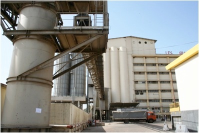
There are 3 major milling companies in Senegal: GMD ( Grand Moulins de Dakar) , NMA (Nouvelle Minoterie Africaine) and les Moulins Sentenac. Almost 75% of Senegal need of flour is assured by “Grands Moulins de Dakar” . Based since 1952 in a strategic position by Dakar port, GMD can mill up to 1250 MT of wheat per day. In case of Emergency GMD could be the only flour provider capable of delivering relevant quantities.
For contact details of all Senegal Milling Companies, please see the following link: 4.5 Senegal Storage and Milling Company Contact List
Milling Company - GMD Grands Moulins de Dakar
|
Company Name & Address |
Contact Names & Email |
Telephone & Fax |
|---|---|---|
|
Grands Moulins de DakarAv Felix Eboue BP 2068 |
Name: Philippe Steffan Title: Directeur général Email: psteffan@gmd.sn Web: www.gmd.sn |
Tel:+221 33 839 9797 + 221 839 9793 +221 77 644 4926 Fax:+221 83 28947 |
|
Summary of Role and Services:
|
||
|
Facilities |
||||
|---|---|---|---|---|
|
Parking area inside compound m² |
n/a |
|||
|
Drainage (Good / Fair / Poor / Non Existent) |
Good | |||
|
Fire Fighting Equipment (Yes / No) |
Yes | |||
|
Number of Ventilators |
n/a |
Screened |
||
|
Electricity Load (KVA) |
1,400,00 |
|||
|
Backup Generator (Yes / No / KVA) |
Yes |
|
KVA GMD owns is own electricity power plant. They don’t rely on Senegal Public Network for the production, but only for the office facilities. |
|
|
Milling Equipment |
|||
|---|---|---|---|
|
Origin of Machinery |
Year of Mfg |
Year of Installation |
Condition |
|
Mill N°1 Unknown |
1992 |
1992 |
Good |
|
Mill N°2 Unknown |
1992 |
1992 |
Good |
| Mill N°3 Swiss | 2003 | 2003 | Good |
|
Maintenance |
|||
|---|---|---|---|
|
Duration (hours / week) |
2 days |
Type of maintenance |
Weekly |
|
Other Equipment or Machinery Installed |
||||
|---|---|---|---|---|
|
Type of Equipment |
Yes/No |
Number |
Owned |
Comments |
|
Fortification Feeder |
Yes |
1 |
Yes |
- |
|
Bag Cleaning Plant |
Yes |
1 |
Yes |
- |
|
Moisture Tester |
Yes |
Unknown |
Yes |
- |
|
De-stoning Plant |
n/a |
n/a |
n/a |
- |
|
Metal Extractor |
n/a |
n/a |
n/a |
- |
|
Staffing |
|
|---|---|
|
Number of full time skilled workers |
75 working on the flour production, 130 in Total |
|
Number of full time labourers |
350 (including administration) |
|
Weighbridge |
||||
|---|---|---|---|---|
|
Number |
- |
Capacity (mt) |
Length (m) |
Type |
|
Within Compound |
2
|
One at the entrance one at the exit |
electronic |
|
|
Pest Control |
|||||
|---|---|---|---|---|---|
|
Fumigation |
Done |
Frequency | n/a |
Contracted (Yes / No) |
n/a |
|
Spraying |
Done |
Frequency | n/a |
Contracted (Yes / No) |
n/a |
|
Rodenticides |
Done |
Frequency | n/a |
Contracted (Yes / No) |
n/a |
|
Rodent Trapping |
Done |
Frequency | n/a |
Contracted (Yes / No) |
n/a |
|
Security |
||
|---|---|---|
|
Security (Good / Poor) |
Good |
|
|
Compound (Fenced / Not Fenced) |
Fenced |
|
| Other Comments | n/a | |
|
Access |
||||||
|---|---|---|---|---|---|---|
|
Distance from main town (km) |
0km |
|||||
|
Travel time if not located in town (hours) |
0 |
|||||
|
Road condition to Mill |
Good |
|||||
|
Road limitation (if any) Maximum Width and Max. Tonnage |
n/a |
|||||
|
Rail connections (Yes / No) |
Yes
|
|||||
|
On the railway from |
Dakar |
to |
Kidra - Bamako |
|||
|
Milling Capacity (Mt) |
||
|---|---|---|
|
Commodities |
Daily Capacity (mt) |
Monthly Activity (mt) |
|
Wheat |
1250 |
25,000 |
|
Maize |
n/a |
n/a |
|
Storage Capacity |
||
|---|---|---|
|
Storage in Metric Tonnes |
Wheat – Covered (mt) |
Flour – Covered (mt) |
|
Within the Compound |
45,000 |
5,000 |
|
Outside the Compound |
n/a |
15,000 |