2.2 Bangladesh Aviation

Introduction to Civil Aviation Authority of Bangladesh (CAAB)
As a member of the International Civil Aviation Organization (ICAO), the CAAB is putting in place necessary infrastructural facilities for movement of domestic and international aircraft. To ensure quick and secured movement of foreign and domestic aircraft in the Bangladeshi sky territory, the CAAB builds and maintains airports, air traffic, and air navigation facilities; installs telecommunication services and provides other facilities for the passengers.
In the year 1985, the Government of the People's Republic of Bangladesh formed Civil Aviation Authority, Bangladesh (CAAB) vide Ordinance No. XXXVIII of 1985, titled The Civil Aviation Authority Ordinance, 1985. CAAB functions as the regulatory body for all aviation-related activities in Bangladesh. Aside from being the aeronautical service provider, it is also responsible for safe, expeditious, and efficient flow of air traffic within the Flight Information Region (FIR) bounded by the international geographic boundary of Bangladesh. This organization is the custodian of all airfields and allied facilities including air navigation facilities. With about 3,000 employees, CAAB operates and maintains the major airports in Bangladesh and all the air traffic control. For further details following link is pertinent: https://caab.portal.gov.bd/
Important Contact details of CAAB
|
Sl |
Name |
Designation and email |
Telephone and fax |
|---|---|---|---|
|
1 |
Air Vice Marshal M Mafidur Rahman BSP, BUP, ndu, afwc, psc |
Designation: Chairman Email: chairman@caab.gov.bd |
Phone: +880 2 8901400 Fax: +880 2 8901411 |
|
2 |
Air Cdre Md. Khalid Hossain BUP, ndc, fawc, psc |
Designation: Member (Ops & Plang) Email: mops@caab.gov.bd |
Phone: +880 2 8901405 Fax: +880 2 8901428 |
|
3 |
Md. Hafizur Rahman (Additional Secretary) |
Designation: Member (Admin), Email: madmin@caab.gov.bd |
Phone: +880 2 8901068 |
|
4 |
Md. Mizanur Rahman (Joint Secretary) |
Designation: Member (Finance), Email: mfin@caab.gov.bd |
Phone: +880 2 8901402 |
|
5 |
Shah Md. Imdadul Haque (Additional Secretary) |
Designation: Member (Security), Email: mavsec@caab.gov.bd |
Phone: +880 2 8901231 |
|
6 |
Group Captain Chy M Zia Ul Kabir GD(P) |
Designation: Director (Flight Safety & Regulations) Email: dfsr@caab.gov.bd |
Phone: +880 2 8901406 |
|
7 |
Md. Abul Kalam Azad Address: AFTN: VGHQYAYS |
Designation: Director (ATS and Aerodromes) Email: datsaero@caab.gov.bd |
Phone: +880 2 8901404 |
|
8 |
Group Captain, Abu Sayeed Mehboob Khan, psc |
Designation: Director, Hazrat Shahjalal International Airport Email: dhsia@caab.gov.bd |
Phone: +880 2 8901449 Fax (office): +880 2 8901450 |
Disaster Response by CAAB
Dhaka and Chattogram Airports Ready for Post-Disaster Needs
|
Airports of Dhaka and Chattogram are prepared to effectively coordinate and handle the massive influx of emergency supplies that floods in after any natural disaster. As part of a global joint initiative between DHL and UNDP, over 20 airport staff and government officials of both airports were trained in 2011 to manage emergency operations, assess local requirements and create detailed contingency plans. A refresher of the same training is currently (2019) being considered. The UNDP-supported Comprehensive Disaster Management Programme 2010-2014 (CDMP II) will continue to work with the Civil Aviation Authority agencies to ensure that the training outcomes are integrated into the broader disaster risk reduction and preparedness activities. |
Procedures for Foreign Registered Aircraft
The provisions detailed here under are related to non-emergency periods. There are, apparently, no specific and detailed provisions for emergency relief operations. Nevertheless, as soon as an emergency state is declared by the authorities, specific procedures for international relief cargo will be edited and implemented.
Entry
All flights into, from or over the territory of Bangladesh and landings in Bangladesh territory shall be carried out in accordance with the permission received from Chairman, Civil Aviation Authority and in accordance with the national regulations. Aircraft landing in or departing from the territory of Bangladesh must first land at or finally depart from an International Airport. The aircraft, after landing at airport shall not proceed further unless the pilot in command has obtained necessary customs and other clearances in writing from officer of such organization as duly authorized by the Government. No aircraft, including aircraft engaged in a scheduled air transport service, shall make flights into or in transit across the territory of Bangladesh except in accordance with the above conditions.
Scheduled Flights
For operation of regular international scheduled flights operated by foreign airlines into or in transit across Bangladesh, the following requirements must be met:
- The state of the airline must be a party either to the International Air Services Transit Agreement, 1944 or a party to bilateral air transport agreement with the Bangladesh Government or must obtain special permission under a bilateral agreement or arrangement.
- The airline must be eligible to make the flights under the provisions of a bilateral or multilateral agreement to which the state of the airline and Bangladesh are contracting parties and must have a permit to operate into or in transit across Bangladesh airspace. Applications for such permits shall be submitted to the Chairman, Civil Aviation Authority, Kurmitola, Dhaka-1229 well in advance.
- Aircraft belonging to or operated for or on behalf of the Government of South Africa, Israel and Taiwan are debarred from flying into or in transit across the territory of Bangladesh.
Non-scheduled Flights
If an operator intends to perform a (series of) non-scheduled flight(s) into Bangladesh for the purpose of taking on or discharging passenger, cargo or mail, he shall apply in writing to the Chairman, Civil Aviation Authority, Government of the People's Republic of Bangladesh, Kurmitola, Dhaka-1229 and obtain prior approval to carry out such operations not less that 15 (fifteen) working days in advance of the intended landing.
The application must include the following information in the order shown hereunder:
- Name, address and nationality of operator of aircraft;
- Type of aircraft, Nationality and Registration Marks of the aircraft;
- Call sign of aircraft;
- Date and time of arrival at, and departure from Bangladesh;
- Place or places of embarkation or disembarkation abroad as the case may be of passengers and/or freight;
- Purpose of flight and details of passengers and/or nature and amount of freight;
- Name, address and business of charterer, if any;
- Route to be flown;
- Such other information as may be required by the Chairman, Civil Aviation Authority.
Charter Flights
If an operator intends to perform a (series of) non-scheduled flight(s) for the purpose of taking on or discharging passengers, cargo or mail in Bangladesh to/from a place outside Bangladesh, he shall apply to and obtain prior approval from the Chairman, Civil Aviation Authority for the exercise of such traffic rights. The application must contain the particulars specified for non-scheduled flights.
No passenger or freight flights originating in Bangladesh for a place outside Bangladesh may be picked up unless the charter/or hire of the whole or part of the space on such aircraft, if considered to have been arranged through the agency of National Operator, and with the prior consent of the Chairman, Civil Aviation Authority of Bangladesh.
Charter flight(s) by Foreign Operators may be permitted provided the Charterer along with the application produces a declaration from the National Carrier stating that they (National Carrier) are not in a position to meet the requirement of the Charterer.
No advertisement in respect of such flights soliciting booking of traffic or purporting to notify availability of space in aircraft shall be made in any manner whatsoever, either by the person or the operator.
Charter Flights by foreign operators not exercising traffic rights when transiting through Bangladesh
Subject to the observance of the terms of the Convention on International Civil Aviation 1944, application must be made at least 3 working days before the intended flight, and obtain prior permission from the Chairman, Civil Aviation Authority of Bangladesh for fall aircraft of the Contracting states of the above-mentioned convention desiring to carry out non-scheduled flight into, or in transit non-stop across Bangladesh and to make stops for non-traffic purposes in Bangladesh. The application must contain the following particulars in the order shown hereunder:
- Name, address and nationality of aircraft operator.
- Type, Nationality and Registration marks of the aircraft
- Date and time of arrival at, and departure from Bangladesh.
- Purpose of flight and details of passengers and/or nature and amount of freight.
- Name, address and business of charterer, if any.
- Route to be flown.
Flights of State Aircraft
If a State intends to perform a (Series of) non-schedule flight(s) into Bangladesh to operate military aircraft, it shall apply to the Government of Bangladesh, Ministry of Affairs, Dhaka, Bangladesh (Telegraphic Address- (PARARASTRA DHAKA) for permission to carry out such operation not less than 15 (fifteen) working days in advance of the intended landing. The application must include the following information in the order shown hereunder:
- Name of operator, Type of aircraft and registration marks.
- Date and time of arrival and departure from Bangladesh.
- Place or places of embarkation or disembarkation of passengers and/or freight, etc.
- purpose of flight and number of passengers and/or nature and amount of freight.
- Route of flight.
- A certificate to the effect that " No war-like materials, such as arms, ammunition, explosives (except escape/aid explosives), pyrotechnics (except very pistol signal cartridges) nuclear fissionable materials, ABC gases, photographic equipment and materials (whether installed or
- not electronic devices other than required for normal operation of the aircraft, are being carried by the aircraft.
Documentary requirements for clearance of aircraft
It is necessary that the under mentioned aircraft documents be submitted by airline operators for clearance on entry and departure of their aircraft to and from Bangladesh. All documents listed below must follow the ICAO standard format as set forth in the relevant appendices to Annex 9 and are acceptable when furnished in English and completed in legible handwriting.
Aircraft documents required for arrival and departure:
|
Required by |
General Declaration |
Passenger Manifest |
Cargo Manifest |
|---|---|---|---|
|
Customs Officer |
1 |
2 |
2 |
|
Immigration Officer |
1 |
1 |
... |
|
Airport Health Officer |
2 |
1 |
... |
|
Plant Quarantine Officer |
1* |
1* |
1* |
|
* For arriving aircraft only |
|||
Notes:
- One copy of the General Declaration is endorsed and returned by Customs, Signifying clearances.
- If no passengers are embarking (disembarking) and no articles are laded (unladed), no aircraft documents except copies of the General declaration need be submitted to the above authorities.
Public health measures applied to aircraft
All international travelers coming to Bangladesh from yellow fever zone or in transit through yellow fever zone must possess a valid International Certificate of yellow fever vaccination. There will not be any exception for age, sex and status.
Yellow Fever: The vaccine used must be approved by the WHO and the vaccination centre must be notified by the WHO. Yellow fever epidemic zones of Africa and South America are given below:
Africa: Angola, Benin Botswana, Burundi, Central African Republic, Chad, Congo, Equatorial Guinea, Ethiopia, Gabon, Gambia, Ghana, Guinea, Guinea-Bissau, Ivory Coast, Kenya, Liberia, Malawi, Mali, Mauritania, Niger, Nigeria, Rwanda, Sao Tome and Principe, Senegal, Sierra Leone, Somalia, Sudan (South of 15 N), Togo, Uganda, United Republic of Cameroon, United Republic of Tanzania, Upper Volta, Zaire, Zambia.
South America: Belize, Bolivia, Brazil, Colombia, Costa Rica, Ecuador, French Guiana, Guatemala, Guyana, Honduras, Nicaragua, Panama, Peru, Suriname, Trinidad, Tobago and Venezuela,
Note: When a case of yellow fever is reported from any Country, that country is regarded by the Government of Bangladesh as infected with yellow fever and is added to the above list.
In case any traveler fails to produce such valid certificate he will either not be permitted to enter Bangladesh or will be isolated till he is considered free from infection by local Health Administration. A simplified E/D-cum Health Card is to be filled in by an arriving passenger of all categories. Desensitization of aircraft in flight is not acceptable. However, spraying on the ground is not required provided a "Desensitization Certificate" from the place of origin is carried on the aircraft. Aircraft and aircrew engaged on non-scheduled flights to Bangladesh shall comply with the requirements of the Convention on International Civil Aviation (Chicago, 1944) and the national regulations in force in Bangladesh.
Cabotage Carriage
No passenger or freight originating at a point in Bangladesh and destined for another point in Bangladesh may be picked up by a foreign operator. If an operator intends to perform a (series of) non-scheduled flight(s) originating at a point in Bangladesh and destined for another point in Bangladesh for the purpose fo taking or discharging passengers, cargo or mail, he shall have to provide satisfactory evidence that no Bangladesh registered operator is in a position to carry the passengers or freight available between the two points in Bangladesh. Thereafter, he shall apply to the Chairman, Civil Aviation Authority for permission to carry out such charter flights.
Other Commercial Flights
If an operator intends to perform a (series of) non-scheduled commercial flight(s) e.g. Business flights, survey flights or spraying flights in Bangladesh he shall apply giving details of the flights(s) to the Chairman, Civil Aviation Authority, Kurmitola, Dhaka-1229 for permission to carry out such operations. Grant of permission will be governed by the merits of the individual cases of consultation with any other department of Government of Bangladesh that may be concerned.
Employment of foreign aircraft for public transportation or aerial works
An aircraft not registered in Bangladesh is precluded from employment as a public transport aircraft or an aerial work aircraft in Bangladesh territory without special permission from the government of Bangladesh, an aircraft owned by a person other than a national of Bangladesh who is resident in resident in or carrying on business in Bangladesh may be registered as Bangladesh aircraft, but is precluded from employment as public transport aircraft or an aerial work aircraft without special authorization from the chairman, CAAB.
Cargo
Regulations
concerning importation, transshipment and exportation of
cargo
Customs requirements: Carriage of arms and explosives
- The Carriage in aircraft of any arms, ammunition, explosives, military stores or articles of highly inflammable nature is prohibited under the Bangladesh Aircraft Rules, except explosives or other articles required exclusively for the working of the aircraft and such arms and ammunition as may reasonably be required for private use.
- No civil registered aircraft, whether national or foreign shall carry ammunition of war or implements of war in or across the territories of Bangladesh.
- Sporting arms and ammunition, explosives (other than those which are used for handling and operating an aircraft), poisons, corrosive liquids or irritant gases, as aesthetic gases, liquids and compounds, flammable solids, liquids or gases, oxidizing materials shall not be carried in bulk on any passenger carrying aircraft, whether national or foreign in or across the territory of Bangladesh except in such quantities as may be notified from time to time.
- When any of the articles mentioned in above is carried, the
carrier shall ensure that:
- The quantity is within the prescribed limits;
- It is properly and securely packed and correctly labeled showing the content of the package with appropriate instructions for handling;
- It is stored in such a place that if the container is damaged, the crew, passenger and the main structure of the aircraft is not likely to endangered by its effects.
- Articles mentioned in paragraph 3 may be transited in bulk through Bangladesh on a foreign registered aircraft provided the owner of the aircraft has obtained prior permission of its Government for conveyance of the cargo on board and 24 hours advance notice of the arrival of aircraft is given to the Airport of intended landing in Bangladesh.
A list of articles which are classified a "Prohibited Cargo" or "Dangerous Cargo" is available at all civil aerodromes.
Plant Quarantine Requirements: Importation of Plants and seeds
The importation of plants and seeds into Bangladesh is governed by special rules. In every case where it is intended to carry plants or seeds on aircraft entering Bangladesh, enquiries should first be made from the Department of Plant Protection, Ministry of Agriculture, Agricultural Complex, Farmgate, Dhaka.
Customs Duty on Airport
No customs duty is levied on an aircraft which is in transit or is to make a temporary stay in Bangladesh for a period of less than six months, However, declaration must be supplied to the Customs Officer at the Airport of entry that the aircraft is in transit or that it is intended to re-export the aircraft within this period.
Wireless Apparatus
In Conformity with the provisions of the International Telecommunications Convention (Atlantic City, 1947) aircraft entering Bangladesh carrying radio transmitting apparatus are required to have a license3 for the apparatus and the operator must hold a certificate of competency. If an aircraft equipped with wireless apparatus arrives in Bangladesh and does not carry the required license and certificate issued by the State in which it is registered, a license for the apparatus and a certificate for the operator must be obtained from the General Manager, Telephones (Wireless Branch), Dhaka, before proceeding.
Airports in Bangladesh
CAAB regulates and maintains total 3 International airports and 7 Domestic airports (of which 2 airports are left unused) and 4 STOL (Short Take-Off and Landing) ports for the convenience of airlines as and when necessary specially in time of crisis. Of the 14 Airports and STOL ports of CAAB, 13 are being operated on subsidy. Hazrat Shahjalal International Airport is the only airport of the Authority, which has surplus earning over its expenditure.
|
International Airports |
|
|---|---|
|
Domestic Airport |
|
| Short Take-off and Landing |
|
|
Note: Place for another airport named Khan Jahan Ali airport is air marked near Mongla Port, Bagerhat and at present its boundary wall is under construction. |
|
Key airport information may also be found at: World Aero Data information on Bangladesh
For information on Bangladesh airports contact details, please see the following link:
4.5 Bangladesh Airport Contact List
2.2.2 Bangladesh Shah Amanat International Airport
| Location Details | |||
|---|---|---|---|
| Country | Bangladesh | Latitude | 22.24972 |
| Province / District | Chittagong | Longitude | 91.81333 |
| Town or City (Closest) |
Chittagong 10 NM N South of Chittagong City |
Elevation (ft and m) | 12 ft / 4 m |
| Airfield Name | Shah Amanat International Airport | IATA and ICAO Codes | CGP / VGEG |
| Open From (hours) | 00.00 | Open To (hours) | 00.00 |
Introduction and Overview
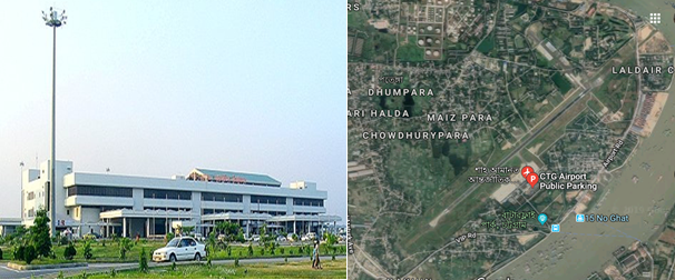
Shah Amanat International Airport (SAIA) is the second-largest international airport in Bangladesh after Shahjalal International Airport in Dhaka. The airport is operated and maintained by the Civil Aviation Authority of Bangladesh. It is used by the Bangladesh Air Force as a part of 'BAF Zahurul Haq Base'. It was renamed on 2 April 2005 after an Islamic saint, Shah Amanat. It is capable of annually handling approx. 2 million passengers and 10,000 MTs of cargo. SAIA also serves as a base to Arirang Flying School. The airport is in the Patenga area of the city, 20 kilometres west from the city's main commercial hub, GEC Circle and 18.5 km south of the city's railway station on the north bank of the Karnaphuli River.
The airfield was built in the early 1940s under the British rule. Known as Chattogram Airfield during World War II, it was used as a combat airfield, as well as a supply point and photographic reconnaissance base by the United States Army Air Forces' Tenth Air Force during the Burma Campaign 1944-1945. After liberation initially it was mainly used for connecting Dhaka and Chattogram. But in the mid-1990s Bangladesh Biman started it’s international flights to Bangkok, Dubai and all other major Gulf cities and it officially became an international airport.
In March 1998, a major renovation and expansion began, which ended in December 2000. CAAB received financial assistance from the Japan International Cooperation Agency for the US$51.57 million upgrade. The upgrade modernised the terminal with new and better seats, more check-in counters, better security equipment and other facilities. The Air Traffic Control tower received new hi-tech equipment such as 3D radar. The runway, taxiways and the tarmac were expanded and improved. After the upgrade, aircraft such as the Boeing 747-400 or the Airbus A 340 can land easily. The Airport is ICAO certified in 2005.
Contact details of the Airport:
|
Name & Address |
Contact Names & Email |
Telephone & Fax |
|---|---|---|
|
Shah Amanat International Airport, Chattogram |
Name: Wg Cdr Sarwar-e- Zaman Title: Airport Manager Email: apmctg@caab.gov.bd |
Tel: 880 31 2500900 (off) |
General Information of SAIA
Briefly Runway and Apron
|
Runway & Lighting
|
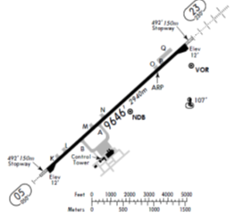
Single Backtrack Runway 05/23 2940m X 45m |
|
|---|---|---|
|
PCN 66 F/C/X/T |
||
|
Runway end turning pads 120m X 80m |
||
|
Precision approach CAT1 lights on RWY 23 |
||
|
Simple approach lights RWY 05 |
||
|
CAT-1 ILS System for RWY23 |
||
|
Apron |
Single Apron 750’ X 430’ with head of stand roadway surrounded by soft grassy areas |
|
|
Four main parking stands are nose in – push out configuration. |
||
|
Standard parking: 2x747-400 + 1x DC10+1 xA380 |
||
|
Dense parking: Standard Parking + 4AN12’s |
||
|
Two taxiway entrances / exits |
||
|
Lighting masts at the head of each stand. |
||
|
Two fixed air bridges which are capable of handling Boeing 747-400 sized A/C. |
Terminal building
The airport's sole 20,000 m2 passenger terminal is divided into two parts: International and Domestic with a boarding bridge in each. The International part of the terminal is larger than the Domestic one due to higher number of passengers. The building is divided into two floors: The lower floor is used for checking in, boarding or getting off small planes and receiving luggage. The upper floor is used for boarding or getting off large planes only. The 2nd Terminal Building is in the active consideration of authority.
Following are some dotted points of the existing Terminal:
- Modern concrete arrival / departure terminal capable of handling approx 2 million passenger per annum.
- 4 departure lounges with suitable seating areas capable of holding 1500 people in total.
- 16 check-in desks.
- 1 domestic arrivals hall and 1 large international arrivals hall.
- Overall size of the terminal building is 18,600m².
- Total number of Bays- 10 (6-Old and 4-New).
Control Tower
The Air Traffic Control Tower is 50 meters west of the airport terminal. This single ATC tower controlling both commercial and military operations. It has a clear view of the tarmac and taxiways but is far from the runway. Heavy rain or fog can make it difficult for controllers to see planes taking off or landing. At present total 16 civilian ATC staff supplemented by BAF controllers work here. They provide 24-hour ATC coverage; however, normal operations are 18-20-hour days. No traffic flow restrictions.
|
Contact : Senior Air Traffic Control Officer, Phone : +88 0312 500 954 and +88 0312 500 982 |
Taxiway and Tarmac
The airport has 2 taxiways, Alpha and Bravo, that directly leads to the tarmac (or aircraft parking zone) from the runway. The tarmac can accommodate a maximum of four aircraft; two wide-body Boeing 747-400s, a wide-body McDonnell Douglas DC-10 and a narrow-body Airbus A320 can be parked there at once. The airport has two boarding bridges and two passenger steps. The parking points are usually empty as most of the planes that arrive there take off soon after. A small civil plane hangar belonging to Biman is available but is rarely used.
The Bangladesh Military has a parking zone and two plane hangars east of the runway. The Bangladesh Air Force store a few planes here, which have direct access to the runway.
Runway Details
|
Airport ID |
Dimensions |
Surface |
PCN |
ILS |
|---|---|---|---|---|
|
05/23 |
9646 x 150 feet 2940 x 46 meters |
PART CONCRETE, PART ASPHALT, OR PART BITUMEN-BOUND MACADAM. |
66 FCXT |
YES |
|
Description |
Runway 05 |
Runway 23 |
|---|---|---|
|
Surface |
Part Concrete, Part Asphalt, or Part Bitumen-Bound Macadam. |
Part Concrete, Part Asphalt, or Part Bitumen-Bound Macadam. |
|
True Heading |
004.80 |
228.0 |
|
Latitude |
22.240814 (22° 14' 26.93" N) |
22.258406 (22° 15' 30.26" N) |
|
Longitude |
91.802653 (091° 48' 09.55" E) |
91.823919 (091° 49' 26.11" E) |
|
Elevation |
12.0 feet (4 meters) |
12.0 feet (4 meters) |
|
Slope |
0.0° |
0.0° |
|
Landing Distance |
9646 feet (2940 meters) |
9646 feet (2940 meters) |
|
Takeoff Distance |
10840 feet (3304 meters) |
9846 feet (3001 meters) |
|
Overrun Length |
1194 feet (364 meters) |
200 feet (61 meters) |
|
Overrun Surface |
Asphalt |
Asphalt |
|
Lighting System |
A4 -PAPI-Portable Lights |
A1-PAPI-Portable Lights |
Airport Data
|
Geographical and Administration Data |
||
|---|---|---|
|
1. |
ARP* coordinates and site at AD* |
221525.28N, 0914919.95E; in the runway |
|
2. |
Distance and direction from city |
10 NM (18.5 km) south of City railway station |
|
3. |
AD elevation/reference temperature |
Elev: 12ft / T: 32degree C (April) |
|
4. |
Magnetic variation |
55' West in 1985 (Annual change negligible) |
|
5. |
Type of traffic permitted |
IFR/VFR |
|
Rescue and Fire Fighting Services |
||
|
1. |
AD category for fire fighting: |
Required category 7, available category 7. |
|
2. |
Rescue equipment available: |
Available to meet the ICAO requirement for category 7. |
|
3. |
Disable Aircraft Removal |
Nil (But in crisis assistance will be provided from Dhaka) |
|
4. |
Seasonal Availability Clearing |
The airport is available for all seasons. Side strips become unusable during monsoon. There is no requirement for clearing. |
|
Surface Movement Guidance, Control System and Markings |
||
|---|---|---|
|
1. |
Use of aircraft stand ID signs, TWY guidelines and visual docking/ parking guidance system of aircraft stands |
Taxiing guidance signs at all intersections with TWY and RWY at all holding positions, Guidelines at apron, Nose-in guidance at airport stands. |
|
2. |
RWY and TWY markings and LGT |
RWY: 05/23. white, omni-directional. |
|
Aerodrome Obstacles |
|||||
|---|---|---|---|---|---|
|
In approach/Take-off areas |
In circling area |
||||
|
RWY affected |
Obstacle type; |
Position |
Marking/ Light |
Remarks |
Obstacles in the circling area at aerodrome are shown on the instrument approach charts and page VGEG AD 2-9 of AIP. All obstruction are provided with day marking and obstruction lighting where necessary and feasible. |
|
23 |
Hill |
064 deg M FM THR RWY 23 |
No |
River Karnaphully flows around RWY23. Masts of ships and boats may constitute mibile obstructions on approach. |
|
|
Meteorological Information Provided |
||
|---|---|---|
|
1. |
Associated Met office |
Shah Amanat Intl. (VGEG) |
|
2. |
Hours of service |
H24 |
|
3. |
Office responsible for TAF preparation and Periods of validity |
Shah Amanat Intl. (VGEG); 12 |
|
4. |
Type of landing forecast Interval of issuance |
TREND; 1/2 hourly |
|
5. |
Briefing/consultation provide |
P, D, T |
|
6. |
Flight documentation and Languages used |
C, PL; English |
|
7. |
Charts and other information available for briefing or consultation |
S,U |
|
8. |
ATS units provided with information |
TWR |
|
9. |
Additional information |
Tel: 880-31-740788, |
|
Declared Distances |
|||||
|---|---|---|---|---|---|
|
RWY |
TORA (m) |
TODA (m) |
ASDA (m) |
LDA (m) |
Remarks |
|
05 |
2940 |
2940 |
3000 |
2940 |
nil |
|
23 |
2940 |
2940 |
3000 |
2940 |
nil |
|
RWY: Runway; TORA: Take-off Run Available; TODA: Take-off Distance Available; ASDA: Accelerate-Stop Distance Available; LDA: Landing Distance Available. |
|||||
|
Approach and runway lighting |
|||||||||
|---|---|---|---|---|---|---|---|---|---|
|
RWY designator |
APCH LGT type |
THR LGT color WBAR |
VASIS (MEHT) PAPI |
TDZ LGT LEN |
RWY centre line LGT |
RWY edge LGT LEN, spacing, color INTST |
RWY end LGT color WBAR |
SWY LGT |
Remark |
|
05 |
Simple approach lighting system |
Green |
3 deg |
nil |
nil |
Last 2000 ft amber rest white omnidirectional with intensity 20%, 40%, 60%, 80%, 100% |
Red unidirectional Green omnidirectional |
nil |
nil |
|
23 |
Simple approach lighting system |
Green |
3 deg |
nil |
nil |
Last 2000 ft amber rest white omnidirectional with intensity 20%, 40%, 60%, 80%, 100% |
Red unidirectional Green omnidirectional |
nil |
nil |
|
Other Lighting, Secondary Power Supply |
|||
|---|---|---|---|
|
1. |
ABN/IBN location, characteristics and hours of operation |
ABN: Over new water tank Altn FLG W G EV 5 Sec (Hours: HN and IMC) |
|
|
2. |
LDI location and LGT Anemometer location and LGT |
Nil |
|
|
3. |
TWY edge and centre line lighting |
Edge: Blue edge lgts for all TWYs |
|
|
4. |
Secondary Power Supply/ Switchover time |
During main power supply failure, Automatic standby generator power supply available within 11 seconds. Kerosene flares availabl. |
|
|
5. |
Remarks |
APRON LIGTHS: available |
|
|
ATS Airspace |
|||
|
Designation |
Chattogram Control Zone |
||
|
1. |
Lateral limits |
A circle of 25 NM radius central on Chattogram VOR (221527.85N 0914938.93E). |
|
|
2. |
Vertical limits |
FL 145 AGL |
|
|
3. |
Airspace |
C |
|
|
4. |
ATS unit call sign/ Language |
Chattogram Tower/ English |
|
|
5. |
Transition altitude |
4000 ft |
|
|
Designation |
Air Traffic Zone (ATZ) |
||
|
1. |
Lateral limits |
ATZ is oval shaped area joining outer tangents of 5 NM (9 km) radius circles centered at the runway centre and both ends of runway |
|
|
2. |
Vertical limits |
4000 ft ALT |
|
|
3. |
Airspace |
C |
|
|
4. |
ATS unit call sign/ Language |
Chattogram Tower/ English |
|
|
5. |
Transition altitude |
4000 ft |
|
|
ATS Communication Facilities |
||||
|---|---|---|---|---|
|
Service designator |
Call sign |
Frequency |
Hours of operation |
Remarks |
|
Aerodrome and Approach Control (Non-Radar) |
Chattogram Tower |
118.7 MHz |
HO* |
Emergency frequency 121.5 MHz; EM: A3 |
|
Surface Control Movement (SMC) |
Chattogram Tower |
112.8 MHz |
HO |
EM: A3 |
|
DATIS |
Chattogram Information |
127.6 MHz |
HO |
|
|
*HO: Service available to meet operational requirements |
||||
|
Radio Navigation and Landing Aids |
|||||
|---|---|---|---|---|---|
|
Type |
Ident |
Freq |
OpHr |
Coordinates |
Remarks |
|
DVOR |
CTG |
113.4 MHz |
H24 |
221527.85N |
373m from THR RWY23. EM:A2 |
|
DME |
|
1168 MHz |
H24 |
221527.85N |
Collocated with DVOR, Elev of Antenna 45ft AMSL, EM:P9 |
|
NDB |
EG |
287 kHz |
H24 |
221504.61N |
2205m fm THR RWY23, EM:A0/A2 |
|
ILS/LLZ |
ICG |
110.5 MHz |
HO |
|
144 deg MAG, 550m FM THR RWY 32, EM:A2 |
|
ILS/GP |
|
332.6 MHz |
HO |
|
Slope: 3 deg, 130 m off-set East, 300 m inward fm RWY 14, RDH 51.57 ft, EM:A3 |
|
TDME |
|
1003 MHz |
HO |
|
Collocated with GP |
|
MM |
|
75 MHz |
HO |
|
049 deg MAG, 905m FM THR RWY 23 |
|
HO: Service available to meet operational requirements |
|||||
Airfield Details
|
Customs |
Yes |
JET A-1 fuel |
Yes |
|---|---|---|---|
|
Immigration |
Yes |
AVGAS 100 |
Yes |
|
Terminal Building |
Yes |
Single Point Refueling |
Yes |
|
Passenger Terminal |
Yes |
Air Starter Units |
Yes |
|
Cargo terminal |
No |
Ground Power (mobile) |
Yes |
|
Pax transport to airfield |
No |
Crash Crew |
Yes |
|
Control Tower |
Yes |
Aircraft Support Services |
Yes |
|
Weather Facilities |
Yes |
Latrine Servicing |
Yes |
|
Catering Services |
No |
Fire Fighting |
Yes |
|
Base Operating Room |
No |
Fire Fighting Category (ICAO) |
Category: VII |
|
Airport Radar |
No |
Fire Fighting Equipment |
Yes |
|
NDB |
Yes |
De-icing Equipment |
No |
|
VOR |
Yes |
IFR Procedures |
Yes |
|
ILS |
Yes |
Runway Lights |
Yes |
|
Approach Lights |
Yes |
Parking Ramp Lighting |
Yes |
Other information for passengers
|
First Aid |
For sick or injured passengers first aid crews from CAAB provide free of cost treatment during watch hours. |
|---|---|
|
Banking System |
Banking facility for foreign currency exchange booth is available in the international terminal building. |
|
Duty Free Shop |
Private and Bangladesh Parjatan Corporation are operating duty free shop for the passenger(s). |
|
Hotel Booking |
Hotel booking booth is available for the passenger(s) for hotel booking. |
|
Pure Drinking Water |
Pure drinking water is available for the passenger(s). |
|
Prayer Room |
Prayer room is available for the passenger(s) |
|
CCTV Camera |
Close circuit camera for the security of the passenger (s). |
|
Wi-Fi |
Free Wi-Fi is available for the passenger(s). |
|
FIDS |
Flight Information Display System is available for the passenger/visitor to know the arrival and departure time of the flights |
|
Luggage Wrapping |
Luggage wrapping facility is available for the passengers to pack their luggage. |
Helicopter Pad
The Airport is also used by military aircraft for their normal operations and training purpose. They use Also helicopters beside other aircraft. In time of emergency this airport can very well be used for any types of helicopters. There is enough facilities for operating number of helicopters in any emergency situation.
Airport Performance (last 5 years)
|
Year |
Cargo Handled (MT) |
Aircraft Movements (000) |
Passenger Handled (in Lac) |
||
|---|---|---|---|---|---|
|
Export |
Import |
Domestic |
International |
||
|
2018 |
2281.72 |
5636.35 |
14238 |
7754 |
16.93 |
|
2017 |
2991.35 |
3270.22 |
13523 |
8034 |
15.27 |
|
2016 |
3741.13 |
2439.71 |
14599 |
6736 |
12.51 |
|
2015 |
2652.07 |
10,680.24 |
12557 |
6677 |
11.71 |
|
2014 |
1553.29 |
13,760.75 |
10999 |
6087 |
10.66 |
Disaster Scenarios at the Airport
|
Cyclones |
|
|---|---|
|
Earthquakes |
|
|
Flooding |
|
Airport Customs
- There is a good setup of Customs authority to take care of the Export/Import formalities through this airport.
- They are fully automated with their universal ASYCUDA World.
- Waivers can / will be issued by the central government via NDMA.
- Large customs area exists within the terminal building.
- Customs officers available 24 hours.
- Sufficient customs staff available for 24 hour operations, however, additional customs staff can be drafted in from the nearby port authority.
- The customs process and policies are under the jurisdiction of the Board of Revenue, not the Civil Aviation Authority.
|
Contact: Assistant Commissioner of Customs, Tel: +88 31 800 423 |
Immigration
- Immigration officers available 24 hours a day.
- An emergency immigration procedure exists in the national disaster plan which allows for speedy processing of foreign aid workers. This plan will be enforced at the request of the NDMA.
- Sufficient immigration officials are present to perform 24 hour operations, however, if required, additional immigration staff can be drafted from the nearby port authority.
|
Contacts: Assistant Police Commissioner (Immigration), Phone: +88 171 337 3272 |
Cargo Handling Procedure and Storage Facilities
Cargo Handling
Biman Bangladesh Airlines is the authorised and responsible agent for handling all Cargo in regard to SAIA. As the airport is not hanlding huge cargo at the moment their arrangements for such operation is also at medium scale. Some times some private operators are also authorised and issued licence by CAAB to operate the cargo and other GSE matters in specific cases. How ever for conducting the present operations smoothly BB has following GSE equipment is place.
GSE Equipment
| Equipment Type | Qty |
|---|---|
| Towing Tractor | 08 |
| Push Cart | 02 |
| Start Cart | 02 |
| Ground Power Unit | 03 |
| Container Pallet Loader (Can’t load at height of Double Decker) | 03 |
| Flash Cart | 02 |
| Water Cart | 02 |
| AC Van (unserviceable) | 01 |
| Passenger Step | 04 |
| Forklift | 02 |
| Belt Loader | 05 |
| Ramp Coach | 02 |
| Catering High Loader | 01 |
| Tow Bar | 05 |
| Forklift | 01 |
Storage Facilities
Warehouse: Though there is no Cargo Village as such like Hazrat Shahjalal International Airport, but this airport has workable facilities. They have 2 warehouses connected to the aircraft apron by tarmac road. One concrete floor space of 2700 m² capable of accommodating 100 MT of freight which is divided into 9 caged areas of various sizes. All scanned cargo is stored in this warehouse from where cargo is delivered on completion of all necessary formalities. The newly built cargo shed is of approx. 3000 m2 capable of accommodating 150 MT freight. This shed is still underutilized. Cargo received from Aircraft are stored here primarily and later shifted to the delivery warehouse for necessary checking and completion of formalities. Landside loading / offloading area providing capacity to park 36 trucks simultaneously.
Cargo operations are owned and controlled by Bangladesh Biman. May be mentioned that Catering facility is available within the landside truck parking area.
Cold Chain: Two large cold storage rooms (12’x10’ and 12’x11’) are in operation which can be accessed from the inside of the warehouse. They maintain temperature between -40 to 100 C to be used as Cold chain for preserving medicine and special items.
Airside loading area, partially covered, providing capability to load / offload 12 trucks simultaneously.
Temporary Warehousing Arrangements
- Though 2 Permanent Cargo warehouse are available, but in time of crisis there is ample opportunity to make temporary arrangements for storing cargo at the airport premise and nearby places.
- The GSE storage and maintenance facility could be made available within 1-2hours for storage and breakdown of air cargo. Approximate size is 800m² hard covered area plus an additional 1600m² of open concrete hard standing. GSE area is accessible by one airside / landside gate and tarmac road to apron.
- A large Red Cross warehouse is available within 1km of the airport facility and can be utilized during disaster relief operations.
- A large factory warehouse is available within 1km of the airport facility and can be utilized during disaster relief operations.
- Warehousing options exists at both the BAF and Naval military installations within 2km of the airport (BAF located on airport site).
- Lot of open space available on the eitherside of warehouses which can be used for cargo storage errecting temporary sheds (open concrete space, usually used for truck operations).
- Office space is available within the GSE building to facilitate distribution administration activity.
| Despite Ltd warehouse capacity on the airport site, a number of larger warehousing options exist close to the airport facility. This gives Chattogram airport greater flexibility in terms of cargo accommodation and relief aid distribution. |
Development Projects
Future Development Works:
- Construction of parallel taxiway
- Extension of existing runway.
- Construction of two Boarding Bridge
- Construction of Cargo Warehouse.
Fuelling Arrangements
Padma Oil Company under the supervision of Bangladesh Petroleum Corporation (BPC) is solely responsible for providing fuel to all kinds of Aircraft at Shah Aamanat International Airport. Arrangements are there to support a full fledget International Airport. The depot is co-located within Half a Km of the airport. Few salient features of this Aviation fuel provider are below:
|
Sl |
Description |
Arrangement |
|---|---|---|
|
1 |
Type of Fuel |
Jet A1 and Avgas |
|
2 |
Tanks with Capacity |
3 Tanks (each 4,22,500 Ltr capacity) |
|
3 |
Requisition for Fuel |
Written requisition with Payment be placed in advance, if prior contaract is not signed. |
|
4 |
Hydrant lines |
The whole airport area is covered under the fuel Hydrant network. At present points are being used and 10 new Hydrant points are being installed. |
|
5 |
Fueling arrangement |
Normally Fueling is done by following refuellers:
|
|
6 |
Filters |
Total-6 (2 for receiving, 2 for Loading and 2 for Hydrants) |
|
7 |
Consumption/Capacity |
Daily approx 210-215 MT/ Capacity 5 Lac Ltrs daily |
|
8 |
Price of Jet A1 |
BDT 75/00 and $ 0.72 per ltr |
|
9 |
AVGAS |
Normally 30-35 Barrels are kept in reserve against monthly consumption of 15-20 Barrels Monthly |
|
10 |
Manpower |
Manager-1, Asst Manager-2, Officers-5, Other staff-19, Casual-12, Ansar-6 |
|
Contact Details |
Depot Manager Cell: 01777703403 & Duty Officer Cell: 01777703309 |
Security Arrangements
- A large security presence exists on the airport with a significant number of airport security personnel.
- Security personnel are under the control of the airport manager.
- A dedicated police station exists within 1km of the airport.
- All access points are guarded by security personnel.
- Due to proximity of BAF military instillation, a large military presence can be drafted in to support policing if required.
- Temporary passes can be issued to airside workers within 30 minutes upon the directive of the NDMA.
- X-Ray screening for both passengers and cargo is in use.
|
Contact: Airport Security Officer, Phone: +88 312 500 941 ext. 212 / 270 |
For information on Bangladesh Shah Amanat International Airport contact details, please see the following link:
4.5 Bangladesh Airport Contact List
Information on some aviation service providers can be found at: AZ Freight information on Bangladesh
Bangladesh - 2.2.1 Bangladesh Hazrat Shahjalal Dhaka InternationalAirport (HSIA)
Introduction of HSIA
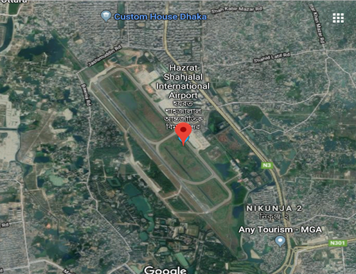
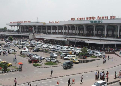
Hazrat Shahjalal International Airport is located in Dhaka City and offers good facilities to passengers as well as cargo traffic. The arrival section of the terminal is situated on the ground floor and the departure section on the first floor.
The airport has a separate domestic terminal, which is located adjacent to the international terminal. The airport has a separate cargo terminal named as the “Cargo Village”, managed by Bangladesh Biman. The airport has good access from the city with wide and well-maintained roads. The surrounding area of the airport was marshy till a few years back. The area has since being filled with sand and level has been made even with the runaway of the airport. At present various development and extension works are going on to improve the capacity and facilities of the largest airport of the country. It is being managed by the Director of the Airport alongwith his expert and experienced team members. For furthur details please go through the link:
https://en.wikipedia.org/wiki/Shahjalal_International_Airport
Airport Contact:
|
Name: Group Captain, Abu Sayeed Mehboob Khan, psc Address: Civil Aviation Authority of Bangladesh, Kurmitola, Dhaka-1229. |
Desig: Director, Hazrat Shahjalal International Airport Email: dhsia@caab.gov.bd |
Phone: +880 2 8901449 Fax (office): +880 2 8901450 |
General Information of HSIA
Airport Location Details
|
Location Details |
|||
|---|---|---|---|
|
Country |
Bangladesh |
Latitude |
235034N, Centre of the runway |
|
Province / District |
Dhaka |
Longitude |
0902402E, Centre of the runway |
|
Town or City (closest) |
Dhaka (Northern part) |
Elevation |
Elevation: 27ft (8m) |
|
Airfield Name |
Hazrat Shahjalal International Airport |
International airport |
Yes |
|
IATA & ICAO codes |
DAC / VGZR |
Open from/to (hours) |
Administration 0900 LT to 1700 LT Operational Services H24 |
Geographical and Administration Data
|
1. |
ARP* coordinates and site at AD* |
235034N, 0902402E; Centre of the runway |
|---|---|---|
|
2. |
Distance and direction from city |
11 NM (20 km) north of Dhaka City (GPO) |
|
3. |
AD elevation/reference temperature |
Elev: 27ft (8m) / T: 35decreeC (April) |
|
4. |
Magnetic variation |
55' West in 1967 (Annual change negligible) |
|
6. |
Type of traffic permitted |
IFR/VFR |
|
* ARP: Aerodrome Reference Point; AD: Aerodrome; APM: Airport Manager |
||
Airfield Infrastructure Details
|
Customs |
Yes |
JET A-1 fuel |
Yes |
Airport Radar |
Yes |
|---|---|---|---|---|---|
|
Immigration |
Yes |
AVGAS 100 |
Yes |
NDB |
Yes |
|
Terminal Building |
Yes |
Single Point Refueling |
Yes |
VOR |
Yes |
|
Passenger Terminal |
Yes |
Air Starter Units |
Yes |
ILS |
Yes |
|
Cargo terminal |
Yes |
Ground Power (mobile) |
Yes |
Approach Lights |
Yes |
|
Pax transport to airfield |
Yes |
Crash Crew |
Yes |
Fire Fighting Equipment |
Yes |
|
Control Tower |
Yes |
Aircraft Support Services |
Yes |
De-icing Equipment |
No |
|
Weather Facilities |
Yes |
Latrine Servicing |
Yes |
IFR Procedures |
Yes |
|
Catering Services |
Yes |
Fire Fighting |
Yes |
Runway Lights |
Yes |
|
Base Operating Room |
Yes |
Fire Fighting Category (ICAO) |
Category: VIII |
Parking Ramp Lighting |
Yes |
Runway Details
|
At present there is only one Runway in this Airport. Due to constant increase in air traffic the authority is planning to have a 2nd runway for HSIA. Meanwhile feasibility studies are also being carried out. Following are the details of the existing runway. |
||||
|
ID |
Dimensions |
Surface |
Strength (PCN) |
ILS |
|---|---|---|---|---|
|
14/32 (CAT-1ILS) |
10500 x 150 feet 3200 x 46 meters |
ASPHALT CONCRETE |
116/F/C/W/T |
YES |
Helicopter Pad(s)
For emergency operations, Bangladeshi Defense Forces use a lot of helicopters from HSIA also. The operational base for these movements is generally Tejgaon Military Airport, +/- 10 KM from DAC. Few of the Private Helicopters operate from the adjacent part of this Airport. They have their own hangers for these helicopters. In time of crisis Military Helicopters also use this portion of airport. List of the Helicopter Operating Companies along with their fleet size is shown at Art No 4.9 Page 491
Airport Performance
|
Performance |
Annual Figures |
Monthly |
Daily |
|---|---|---|---|
|
Total aircraft movements |
87,000 (Total landing and Taking off) |
7250 |
242 |
|
Total passengers |
8.4 M |
7,00.000 |
23333 |
|
Total Cargo handled (Year 2017-2018) |
3,66,019 MT (Export and Import) |
30502 MT |
1017 |
|
Total capacity of the airport (MT) daily |
150 MT |
n/a |
n/a |
|
Current activity of the airport (MT) daily |
100 MT |
n/a |
n/a |
|
Current use by Humanitarian flights (UNHAS) |
As and when required depending on the situation |
||
Airport Operating Details
|
Max size aircraft that can be offloaded on bulk cargo |
Boeing 747 (100MT Cargo)/ AN-124/ Boeing 777 |
|---|---|
|
Max size cargo aircraft that can be offloaded on pallet |
Boeing 747 (100MT Cargo)/ AN-124/ Boeing 777 |
|
Total Parking Area |
99,000 m² |
|
Storage Area |
27,800 m² |
|
Cargo Handling Equipment |
Yes |
|
Elevators / Hi-loaders |
Yes |
|
Can Hi-loader/Elevators reach the upper deck of B747/777? |
Yes |
|
Loading Ramps |
Yes |
Terminal Facilities
The terminal facilities of HSIA contain 1 floor domestic passenger terminal building, 3 floors international passenger terminal building, 1 floor domestic/international cargo terminal building, VVIP terminal building, infrastructure supply facility, management/office building. Related facilities are independent in the terminal area. There are 2 terminals i.e. terminal 1 and terminal 2 for the international passengers which are connected. These 2 terminals share same departure lobby and departure gates. The existing international passenger terminal 1 and terminal 2 which are in the same building with floor area of 73,400 m2 and Domestic Passenger Terminal 2,200 m2. Soon construction of the 3rd terminal will start under the consultancy of JAICA at the cost of BDT 136.10 billion, which is expected to be completed by 2022. Apart from a 226,000-square meter terminal building, a new cargo village, VVIP complex, and rapid exit, connecting taxiways and an oil depot will be constructed under the project. After construction of the third terminal, passenger handling capacity will increase to 20 million and cargo handling capacity to 500,000, according to the CAAB.
Other Operational Details
|
Rescue and Fire Fighting Services |
|||||||||||||||||||||||
|---|---|---|---|---|---|---|---|---|---|---|---|---|---|---|---|---|---|---|---|---|---|---|---|
|
1. |
AD category for firefighting: |
Required category VIII, available category VIII. Facilities available for foaming runway. |
|||||||||||||||||||||
|
2. |
Rescue equipment available: |
To meet ICAO requirement for category VIII. |
|||||||||||||||||||||
|
3. |
Disable aircraft removal: |
||||||||||||||||||||||
|
|||||||||||||||||||||||
|
4. |
Remarks |
N/A |
|||||||||||||||||||||
|
Seasonal Availability Clearing |
|---|
|
The airport is available for all seasons. Side strips become unusable during monsoon. There is no requirement for clearing. |
|
Aprons, Taxiways and Check Location Data |
||
|---|---|---|
|
1. |
Apron surface and strength |
Surface : Concrete. |
|
2. |
Taxiway width, surface and strength |
Width : 23 m. |
|
3. |
ACL Location |
Not designated |
|
4. |
INS checkpoints |
Nil |
|
5. |
Remarks |
Nil |
|
Surface Movement Guidance, Control System and Markings |
|
|---|---|
|
Use of aircraft stand ID signs, TWY guidelines and visual docking/ parking guidance system of aircraft stands |
Taxiing guidance signs at all intersections with TWY and RWY at
all holding positions, |
|
RWY and TWY markings and LGT |
RWY: 14/32. |
|
Stop Bars |
N/A |
|
Aerodrome Obstacles |
|
|---|---|
|
In approach/Take-off areas |
In circling area and at aerodrome |
|
Consult AOC type-A, HSIA, Page VGHS AS 2-16 |
Obstruction in the circling area are shown on the instrument approach chart and page VGHS AD 2-11 |
|
Meteorological Information Provided |
||||||||
|---|---|---|---|---|---|---|---|---|
|
1. |
Associated Met office |
HSIA (VGHS) |
||||||
|
2. |
Hours of service |
H24 |
||||||
|
3. |
Office responsible for TAF preparation and Periods of validity |
HSIA (VGHS); 6,12 |
||||||
|
4. |
Type of landing forecast Interval of issuance |
TREND |
||||||
|
5. |
Briefing/consultation provide |
P, D, T |
||||||
|
6. |
Flight documentation and Languages used |
C, PL; English |
||||||
|
7. |
Charts and other information available for briefing or consultation |
S,U |
||||||
|
8. |
Supplementary equipment available for providing information |
WXR |
||||||
|
9. |
ATS units provided with information |
Dhaka ACC/FIC; APP; TWR |
||||||
|
10. |
Additional information |
Tel: 880-2-8914543 (Met office) |
||||||
|
Runway Physical Characteristics |
||||||||
|
Designator RWY NR |
True & MAG BRG |
Dimensions of RWY (m) |
Strength (PCN) and surface of RWY & SWY |
THR coordinates |
THR ELEV and highest ELEV of TDZ of PAR |
Slope of RWY-SWY |
||
|
14 |
144 deg True |
3200x46 |
59/F/B/W/T |
235118.11N |
27 |
nil |
||
|
32 |
324 deg True |
3200x46 |
59/F/B/W/T |
234954.00N |
27 |
nil |
||
|
Designator RWY NR |
SWY dimensions (m) |
CWY dimensions (m) |
Strip dimensions (m) |
OFZ |
Remarks |
|||
|
14 |
275x46 |
275x153 |
3750x153 |
Within the CWY. |
25 ft (8 m) brick soling with bitumen carpeting shoulder at both side of RWY. |
|||
|
32 |
275x46 |
275x153 |
3750x153 |
|||||
|
Declared Distances |
|||||
|---|---|---|---|---|---|
|
RWY |
TORA (m) |
TODA (m) |
ASDA (m) |
LDA (m) |
Remarks |
|
14 |
3200 |
3475 |
3475 |
3200 |
N/A |
|
32 |
3200 |
3475 |
3475 |
3200 |
N/A |
|
RWY:Runway; TORA:Take-off run available; TODA:Take-off distance
available; |
|||||
|
Approach and runway lighting |
|||||||||
|---|---|---|---|---|---|---|---|---|---|
|
RWY designator |
APCH LGT type |
THR LGT color WBAR |
VASIS (MEHT) PAPI |
TDZ LGT LEN |
RWY centre line LGT |
RWY edge LGT LEN, spacing, color INTST |
RWY end LGT color WBAR |
SWY LGT |
Rem |
|
14 |
Precision approach CAT-I lighting system Simple approach lighting system and sequenced flashing lights Supplementary approach |
Green supple-mented by green Wingbar |
PAPI 3 deg |
available |
available |
60 m apart white omni-directional with intensity 3%, 10%, 30%, 80%, 100% |
Red unidirectional Green omnidirectional |
available |
nil |
|
32 |
Simple approach lighting system |
Green supple-mented by green Wingbar |
PAPI 3 deg |
available |
available |
60 m apart white omni-directional with intensity 3%, 10%, 30%, 80%, 100% |
Red unidirectional Green omnidirectional |
available |
nil |
|
Other Lighting, Secondary Power Supply |
||||
|---|---|---|---|---|
|
1. |
ABN/IBN location, characteristics and hours of operation |
ABN: 235057.20N 0902413.24E Over Control TWR) |
||
|
2. |
LDI location and LGT |
Nil |
||
|
3. |
TWY edge and centre line lighting |
Edge: Blue edge lgts for all TWYs |
||
|
4. |
Secondary Power Supply/ Switchover time |
During main power supply failure, Automatic standby generator power supply available for Apch, RWY, TWY and Apron lighting within 15 seconds |
||
|
5. |
Remarks |
APRON LIGTHS: High Intensity Flood Lights |
||
|
ATS Airspace |
||||
|
Designation |
Dhaka Control Zone |
|||
|
1. |
Lateral limits |
A circle of 25 NM radius central on Dhaka VOR (234928.86N 0902445.36E) except that portion which falls north of the strait line joining points 241147N 0903550E and 241147N 0901350E |
||
|
2. |
Vertical limits |
GND to FL055 |
||
|
3. |
Airspace |
C |
||
|
4. |
ATS unit call sign/ Language |
Dhaka Tower/ English |
||
|
5. |
Transition altitude |
4000 ft MSL |
||
|
6. |
Remarks |
Nil |
||
|
Designation |
Aerodrome Traffic Zone (ATZ) |
|||
|
1. |
Lateral limits |
ATZ is oval shaped area joining outer tangents of 5 NM (9 km) radius circles centered at the runway centre and both ends of runway |
||
|
2. |
Vertical limits |
4000 ft |
||
|
3. |
Airspace |
C |
||
|
4. |
ATS unit call sign/ Language |
Dhaka Tower/ English |
||
|
5. |
Transition altitude |
4000 ft MSL |
||
|
6. |
Remarks |
Nil |
||
|
ATS Communication Facilities |
||||
|---|---|---|---|---|
|
Service designator |
Call sign |
Frequency |
Hours of operation |
Remarks |
|
Area Control (ACC) |
Dhaka Tower |
125.7 MHz |
H24 |
Emergency frequency 121.5 MHz |
|
TWR (Aerodrome and Approach Control, Non-Radar) |
Dhaka Tower |
118.3 MHz |
H24 |
EM: A3 |
|
APP (Radar/Non-Radar) |
Dhaka Approach |
121.3 MHz |
0130-1400 daily except Saturday; 0800-1400 on Saturday |
Emergency frequency 121.5 MHz. |
|
Radar |
Dhaka Radar |
126.7 MHz |
HO |
Only monitoring service is provided on request. |
|
SMC |
Dhaka Ground |
121.8 MHz |
H24 |
N/A |
|
Air-Ground |
Dhaka Radio |
3491, 6556, 10066, 2947 kHz |
H24 |
MWARA (3491, 6556, 10066 kHz) |
|
ATIS |
Dhaka Information |
127.4 MHz |
H24 |
N/A |
|
Note: During OJT (on the job training) in TWR, APP (Non-Radar), ACC or Radar Approach Control Service at HSIA will be Ltd. However, Radar Approach Control Service may be available during OJT on request. |
||||
|
Radio Navigation and Landing Aids |
|||||
|---|---|---|---|---|---|
|
Type |
Ident |
Freq |
OpHr |
Coordinates |
Remarks |
|
DVOR |
DAC |
112.7 MHz |
H24 |
234928.86N |
144 deg MAG, 958m FM THR RWY 32, EM:A2 |
|
DME |
|
1161 MHz |
H24 |
234928.86N |
Collocated with DVOR, Elev of Antenna 49ft AMSL, EM:P9 |
|
NDB |
DCN |
298 kHz |
H24 |
235034.32N |
046 deg MAG, 1795m fm THR RWY32, EM:A2 |
|
ILS/LLZ |
IDA |
109.5 MHz |
H24 |
234940.04N |
144 deg MAG, 550m FM THR RWY 32, EM:A2 |
|
ILS/GP |
|
332.6 MHz |
H24 |
235112.67N |
Slope: 3 deg, 130 m off-set East, 300 m inward fm RWY 14, RDH 51.57 ft, EM:A3 |
|
MM |
|
75 MHz |
H24 |
235145.75N |
324 deg MAG, 1050m FM THR RWY 14, EM:A2 |
|
OM |
DA |
75 MHz |
H24 |
235557.71N |
324 deg MAG, 5.8NM FM THR RWY 14, EM:A2 |
|
OL |
|
375 kHz |
H24 |
235558.39N |
324 deg MAG, 5.8NM FM THR RWY 14, EM:A2 |
Bird Concentration
Bird concentrations may exist on or in the vicinity of HSIA due to low laying area around the airfield, during the period from December to May of the year. Bird shooters are posted in the maneuvering area to reduce the bird hazard. Moreover, necessary information about the location of birds, if visible, is transmitted to the pilots by Aerodrome Control Tower. However, pilots are requested to exercise caution while approaching to land and take-off.
Cargo Handling Procedure and Storage Facilities
Both inbound and outbound cargo are carefully and systematically handled by the cargo division of Bangladesh Biman. Import Terminal is used for handling inbound cargo and a separate terminal known as Cargo Village is used for exporting cargo through HISA. Sufficient Cargo handling equipment facility is being managed by GSE division of Bangladesh Biman.
Import Cargo Terminal
- There is a 2 storied Import Terminal and a concrete structured warehouse area with direct access to apron.
- Cargo operations are owned and controlled by Bangladesh Biman (National Carrier).
- Concrete floor space of 15,000m² area.
- Landside loading / offloading area provided.
- 2 nominal aircraft parking spots in front of building.
- Total warehousing area is insufficient and therefore, mostly the imported cargo remains in the open air on the concrete ground.
Export Cargo Terminal
- The Cargo Export terminal is called Cargo Village situated on the northern side of the Airport.
- The complex is separated from Import Cargo terminal and has direct access to apron.
- Cargo operations are owned and controlled by Bangladesh Biman.
- Concrete floor space of 12,800m².
- Landside loading / offloading area provided.
- nominal aircraft parking spots are there in front of building.
Handling Services and Facilities
Biman Bangladesh Airlines (BB) is given the responsibility of handling the total Cargo services including proving General Service Equipment as required. At present they have following handling equipment which seems to be in sufficient for managing cargo in time of crisis or special operation:
|
Sl |
Description |
Qty |
|---|---|---|
|
1 |
Water Cart |
03 |
|
2 |
Air Start Unit |
05 |
|
3 |
Air Conditioning Unit |
02 |
|
4 |
Ambulift |
02 |
|
5 |
Belt Loader |
11 |
|
6 |
Mobile Cranes |
01 |
|
7 |
Container Pallet Loaders |
13 |
|
8 |
Catering Hi-Lift |
06 |
|
9 |
Container Pallet Transporters |
08 |
|
10 |
Delivery Van |
01 |
|
11 |
Flush Cart |
02 |
|
12 |
Fork Lift |
07 |
|
13 |
Fuel Brouser |
01 |
|
14 |
Ground Power Unit |
18 |
|
15 |
Narrow Asle Stacker |
11 |
|
16 |
Push Back Tow Tractor |
07 |
|
17 |
Passenger Steps |
08 |
|
18 |
Ramp Coach |
07 |
|
19 |
Tow Tractor Baggage |
37 |
|
Total |
150 |
|
Ground Handling Agency
Biman provides ground handling facilities to all airports in Bangladesh and is approved by the Civil Aviation of Bangladesh, as the sole ground handler to all foreign carriers’ flights operating on commercial basis. It has sufficient ground handling equipment and experienced manpower to handle all type of aircraft.
All schedule/non-schedule operators may contact with the following address to get the latest information related to ground handling at any Bangladeshi airport:
List of Officers - Biman Bangladesh Airlines
| Name | Designation | Phone | Mobile | |
|---|---|---|---|---|
| Capt. Farhat Hassan Jamil |
Managing Director & CEO |
+88-02-8901700 |
01777715501 |
|
| Ziauddin Ahmed |
Director, Administration |
+88-02-8901701 |
01777715506 |
|
| Kazi Atiqur Rahman |
Company Secretary |
02-8901383 |
01777715510 |
|
| Nurul Islam Howlader |
GM, Airport Services |
+88-02-8901550 |
01777715531 |
|
| Md. Atique Sobhan |
General Manager, Customer Services |
+88-02-8901770 |
01777715532 |
|
| Shahnoor Ahmad |
DGM, Ground Service |
+88-02-8901303 |
|
|
| Md. Rashedul Karim |
General Manager, Ground Support Equipment |
+ 88-02-8901২93 |
01777715552 |
|
| Md Shamsul Karim |
DGM, Transport Department |
+88-02-8901532 |
01777715550 |
Cargo Import Export Procedure
Import Procedure
- Cargo received from Aircraft (along with Air Waybill and Cargo manifest).
- Then they are segregated, sorted and stored at the warehouse by Ground Cargo Handler (BB)
- As per AWB the Consignee is informed/ Consignee goes to Cargo office.
- Consignee/ their authorized C&F agent collects AWB and goes to Customs authority
- Customs puts a Rotation Number, Examine the goods for Tax/Waiver/unauthorized goods etc.
- Upon examination Customs authority provides clearance to release Goods.
- At the cargo yard (Import) after payment of the Handling charges or Storage charges (if any) the goods are delivered to the agent.
- The C& F agent will make transportation arrangements beyond airport.
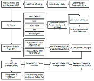
Export Procedure
- Exportable Cargo to be delivered to the Cargo Village of BB
along with following:
- Cargo well packed and marked with Labels
- Invoice
- Packing List
- Customs Clearance Certificate for export (Ex BOE)
- Gate Pass mentioning the AWB number.
- Cargo received at the Acceptance area by BB where items will be measured and AWB will be prepared.
- FF agent will then send all documents to Customs for final clearance and payments etc.
- On receiving final clearance from Customs cargo will be Scanned by Duel view scanning machine (total having 6) and for EU countries by EDS machine (total having 2).
Once cargo is checked, it is sent to Loading area for Export.
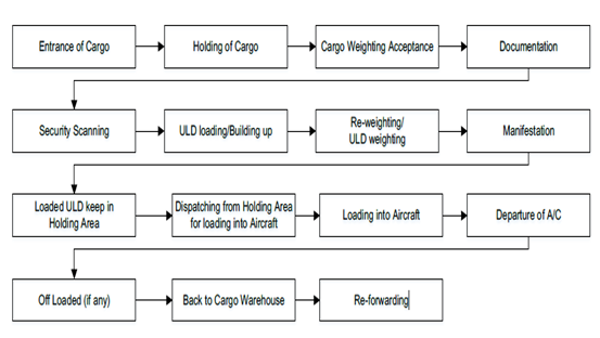
Airport Charges and Fees (As of 2019)
The charges set out are common to all Civil Aviation Authority administered aerodromes except where the contrary is stated.
Unless an alternative arrangement has been made, all charges for use of aerodromes are payable by the pilot of the aircraft on demand or before the aircraft departs from the aerodrome.
Fees shall be paid to the Chairman, Civil Aviation Authority and if not so paid shall be a debt due to Government of Bangladesh from the owner and the Commander of the aircraft in respect of which the fees are payable.
For the purpose of enforcing payment of fees, the Chairman, Civil Aviation Authority may refuse to permit and aircraft to take off from an aerodrome until all fees have been paid.
No abatement of any fees shall be allowed in the event of any aerodrome service, assistance or other facility being not available and except as provided in these Regulations no exemption or remission shall be granted.
Exemption
Landing Charges, Parking and Housing Charges, Boarding Bridge Fees, Security Charges, Charges for flights beyond hours of operation and Route Navigation Charges shall not be applicable in the following cases, namely:
- An aircraft belonging to the United Nations Organization or any of its agencies or International Red Cross engaged in medical relief for humanitarian mission
- An aircraft engaged on non-remunerative basis in search and rescue operations or medical relief or humanitarian mission
- Any aircraft engaged in air calibration work;
- An aircraft belonging to Flying Clubs approved by CAAB engaged in training purpose;
- State aircraft of Bangladesh;
- Such aircraft as the Government may deem fit to exempt.
Navigation Charges (US$)
|
MTOW (Maximum Take-Off Weight) in the Certificate of Airworthiness |
International flight |
Domestic flight |
|---|---|---|
|
Not exceeding 2,000 kg |
BDT equivalent of USD 12 |
BDT 75 |
|
Over 2,000 kg but not exceeding 5,000 kg |
BDT equivalent of USD 24 |
BDT 150 |
|
Over 5,000 kg but not exceeding 10,000 kg |
BDT equivalent of USD 30 |
BDT 225 |
|
Over 10,000 kg but not exceeding 20,000 kg |
BDT equivalent of USD 75 |
BDT 450 |
|
Over 20,000 kg but not exceeding 50,000 kg |
BDT equivalent of USD 150 |
BDT 900 |
|
Over 50,000 kg but not exceeding 100,000 kg |
BDT equivalent of USD 300 |
BDT 1800 |
|
Over 100,000 kg but not exceeding 200,000 kg |
BDT equivalent of USD 420 |
BDT 3000 |
|
Over 200,000 kg |
BDT equivalent of USD 450 |
BDT 3750 |
Landing Charge
Basis: MTOW (Maximum Take-Off Weight) in the CoA (Certificate of Airworthiness).
The charges for landing an aircraft at Government Airports / Aerodromes are as follow:
|
Total weight of the Aircraft as provided in the certificate of airworthiness |
Single Landing charges (Calculated nearest 1000 kg.) |
|
|---|---|---|
|
International flights |
Domestic flights |
|
|
Not exceeding 10,000 kg |
Such amount of BDT as is equivalent to US$ 5.25 per 1000 kg. |
BDT 53 per 1000 kg. |
|
Over 10,000 kg. but not exceeding 20,000 kg |
Such amount of BDT as is equivalent to US$ 6.75 per 1000 kg. |
BDT 68 per 1000 kg |
|
Over 20,000 kg. but not exceeding 50,000 kg. |
Such amount of BDT as is equivalent to US$ 7.5 per 1000 kg. |
BDT 83 per 1000 kg |
|
Over 50,000 kg. but not exceeding 1,00,000 kg |
Such amount of BDT as is equivalent to US $9.75 per 1000 kg. |
BDT 150 per 1000 kg. |
|
Over 1,00,000 kg. but not exceeding 3,00,000 kg |
Such amount of BDT as is equivalent to US $12 per 1000 kg |
BDT 188 per 1000 kg. |
|
Over 3,00,000 kg |
Such amount of BDT as is equivalent to US $ 12.75 per 1000 kg |
BDT 315 per 1000 kg. |
- The charges may also be paid in US Dollars.
- 10% extra charge for each landing or take-off after sunset and before sunrise.
- Only 50% of the landing charges, in case the aircraft is engaged in training purpose.
- In case an aircraft is engaged in test flight only, with the approval of the Airport Manager, only 25% of the landing fees will be charged.
Parking and Housing Charges
- Parking charges for each 24 hours period or part thereof: 25% of the landing charges when the parking period exceeds 6 hours;
- Hangar charges for each 24 hours period or part thereof: 50% of the parking charges;
- Monthly charges for both parking and hangar: 20 times the 24 hours parking / hangar charge
- Quarterly charges for both parking and hangar: 50 times the 24 hours parking / hangar charge
- Without written approval the Chairman CAAB, no aircraft shall be allowed to stay on the apron for more than 3 months.
Boarding Bridges Fees
- Hourly rates for using the Boarding Bridge:
|
Rate for the first two hours (on hourly basis) All up weight of aircraft (kg) |
Charge (US$) |
|---|---|
|
Below 100,000 |
100 |
|
From 100,000 to below 200,000 |
150 |
|
From 200,000 to below 300,000 |
200 |
|
300,000 and above |
250 |
- Basic Boarding Bridge charges as mentioned above are applicable for the first two hours only.
- If an aircraft uses Boarding Bridges for more than two hours, the rate for each additional half-an-hour, or part thereof, shall be as follows:
|
All up weight of aircraft (kg) |
Charge (US$) |
|---|---|
|
Below 100,000 |
60 |
|
From 100,000 to below 200,000 |
75 |
|
From 200,000 to below 300,000 |
90 |
|
300,000 and above |
125 |
Discount in additional charges at Hazrat Shahjalal International Airport
- If the period of the additional use of the Boarding Bridge the Airport is not in conceding with the busy hours of operation, the applicable rates shall be only 50% of the rates mentioned above.
- The right definition of the hours of operation at the airport as busy or non-busy lies with the Civil Aviation Authority. The timing will be circulated to the operators at the time of approving the schedule and may be amended from time to time.
- The period of use of Boarding Bridge shall be reckoned from the time an aircraft docks in, to the time the aircraft starts pushing back.
- Discount for frequent users
- Discount Charge for the frequent users of Boarding Bridges shall be as follows:
|
Hours used weekly |
Rate |
|---|---|
|
61 to 90 hours |
5% |
|
91 to 120 hours |
7.5% |
|
121 hours and above |
10% |
|
Note: The hours mentioned above are cumulative. |
|
Charges for flight Beyond Hours of Operation
The charges for utilizing airport or aerodrome facilities and air route navigation facilities for flights operating beyond hours of operation:
|
For use of airport or aerodrome facilities
|
International Flights |
The amount of BDT equivalent to US $ 225 per hour or part thereof. |
|---|---|---|
|
Domestic Flights |
BDT 4500 per hour or part thereof. |
|
|
For use of air route navigation facilities |
|
The amount of BDT equivalent to US $ 90 per hour or part thereof. |
Cargo Terminal Charges
|
Import |
Rate US$/kg |
|---|---|
|
Import storage charge |
03 days free |
|
Cargo and Mail Handling Charge for skd |
0.07 US$ per Kg |
|
Cargo and Mail Handling Charge for non skd |
0.10 US$ per Kg |
|
Dangerous goods handling fee for import |
US$ 100 |
|
Live animal handling fee for import |
10 US$ per AWB |
|
Forklifts charge for import |
3 BDT per Kg |
|
Cool room storage charges |
1-7 days: BDT 50 per unit of 50 Kg 8-14 days: BDT 100 per unit of 50 Kg 14 + days: BDT 600 per unit of 50 Kg |
|
Strong room storage charges (3 days free) |
03-13 days 50 BDT/ Unit (Per Unit 50 kg) 13-21 days 200 BDT/ Unit (Per Unit 50 kg) 21+ days 600 BDT/ Unit (Per Unit 50 kg) |
|
Import handling fee |
5 BDT/ kg |
|
Export |
Charges |
|
Security escorting charges for VAL cargo (on request) |
US $ 100 |
|
Export Storage Charge |
30 hours free |
|
Terminal handling charges |
0.08 US$/Kg |
|
Cargo and Mail Handling charge for skd |
0.08 US$/Kg |
|
Cargo and mail handling charge for non skd |
0.10 US$/Kg |
|
Security Scanning Charge (CAAB) |
0.06 US$/Kg |
|
Reweighing charge for export (On request) |
US$ 10 per AWB |
|
Dangerous goods handling fee for export |
US$ 100 |
|
Live animal handling fee for export |
10 US$ per AWB |
|
Forklift charge for export |
BD BDT 3/ Kg |
|
Full airways bill data transmission (FWB) |
5 US$ per AWB |
|
House airway bill data transmission (FHL) |
5 US$ per AWB |
|
RA3 handling charge for export |
0.02 US$ Kg |
Charges for Passenger Boarding Bridge (PBB)/ Air-bridge / Sky Bridge/ Jet Bridge
- Hourly rates for using Boarding Bridge at all airports or aerodromes of Bangladesh shall be as follows:
|
All up weight of the aircraft (kg.) |
Charges (US$) |
|---|---|
|
Below 100,000 |
100 |
|
From 100,000 to below 200,000 |
150 |
|
From 200,000 to below 300,000 |
200 |
|
300,000 and over |
250 |
- Basic boarding bridge charges as mentioned in clause A shall apply for the first 2 (two) hours only.
- If an aircraft uses Boarding Bridge for more than 2 (two) hours, the rates for each additional half-an-hour, or part of thereof, shall be as follows:
|
All up weight of the aircraft (kg.) |
Charges (US$) |
|---|---|
|
Below 100,000 |
60 |
|
From 100,000 to below 200,000 |
75 |
|
From 200,000 to below 300,000 |
90 |
|
300,000 and over |
125 |
- If the period of additional use of the Boarding Bridge at Hazrat SHahjalal International Airport is not in Busy hours of operation, the applicable rates shall be 50% of the rates mentioned in clause C.
- The right for edclaration of the hours operation at Hazrat Shahjalal International Airport as busy or non-busy lies with the Civil Aviation Authority. The timing will be circulated to the operators at the time of approving the schedule and may be amended from time to time.
- the period for the use of Boarding Bridge shall be reckoned from the time an aircraft docks in, to the time the aircraft starts to push back.
- Discount Charges for the frequent users of Boarding Bridges shall be as follows:
|
Hours Used Weekly |
Rates of Discount |
|---|---|
|
61 - 90 Hours |
5% |
|
91 - 120 Hours |
7.5% |
|
121 Hours and above |
10% |
|
The hours mentioned above shall be cumulative. |
|
Humanitarian Staging Area (HSA)
In fact, the present cargo storage facilities of the airport are insufficient, and the authority is facing tremendous problems to support the exporters and importers in their regular operations. So, it will be very difficult to handle huge influx of imported cargo in time of crisis. Considering the fact, the government of Bangladesh has decided to allocate a piece of land at Purbachal area (approx. 15 KM south-east of Airport). This will be known as “Humanitarian Staging Area” to be developed by WFP Bangladesh in collaboration with the Ministry of Disaster Management and Relief (MoDMR) which will be used by the UN and other humanitarian organizations and NGOs for managing their humanitarian cargo. The area is well connected by road and new extension of the town is going to be established there in near future. Suitable numbers of sheds and warehouses will be built in the area and cargo will be directly transported from airport to this area for sorting, storing and transporting for subsequent distributions.
Development Projects
Recently Completed Development Works:
- Extension of passenger apron from foxtrot taxiway towards west and export cargo apron from northern side of the existing export cargo apron at Hazrat Shahjalal international airport, Dhaka.
- Asphalt concrete overlay over the existing runway at Shahjalal international airport, Dhaka.
- Upgrade of Hazrat Shahjalal international Airport, Dhaka.
- Consultancy Services for the Up gradation of Hazrat Shahjalal International Airport, Dhaka.
- Consultancy services for Construction of 3rd Terminal, 2nd Runways and other infrastructure Development Works at Hazrat Shahjalal International Airport, Kurmitola, Dhaka.
On Going Development Works:
- Consultancy and delivery of services for improvement of security system at Hazrat Shahjalal international Airport, Dhaka.
- Construction of CAAB Headquarters Complex at Hazrat Shahjalal International Airport, Kurmitola, Dhaka.
- Extension of apron towards north of the existing export cargo apron at Hazrat Shahjalal international Airport, Dhaka (Phase-11).
- Construction of General Aviation Hangar, Hangar Apron & Apron North side of fire station at Hazrat Shahjalal international Airport, Dhaka.
- Construction of 3rd Terminal, at Hazrat Shahjalal International Airport, Kurmitola, Dhaka.
Future Development Works:
- Hazrat Shahjalal International Airport, Dhaka Expansion Project.
Fuelling Arrangement at HSIA
Padma Oil Company under the supervision of Bangladesh Petroleum Corporation (BPC) is solely responsible for providing fuel to all kinds of Aircraft at HSIA. It is located at Kurmitola adjacent to the HSIA airport. Few salient features of this Aviation fuel provider are below:
|
Description |
Arrangement |
|---|---|
|
Type of Fuel |
Jet A1 and AV Gas (F gas 100LL) |
|
Tanks with Capacity |
Jet A1 - 12 Tanks with total 8500 MT storage capacity. AV Gas- approx. 600 drums (as per requirement) |
|
Requisition for Fuel |
Written requisition with Payment be placed in advance |
|
Hydrant lines |
Approx 4 KM Hydrant pipe lines are laid from depot to airport area with 21 fueling points against 29 bay. |
|
Fueling arrangement |
Fueling is done by 11 Dispenser and 7 refuelers having tank capacity of 18,000 ltrs each. |
|
Consumption |
Yearly approx. 40,000 MT (Daily avg 1,000 MT) |
|
Price of Jet A1 |
BDT 75/00 and $ 0.72 per ltr |
|
Safety |
Ensured by IATA and JIG |
|
Tech assistance |
Provided by SHELL |
Contact Details
|
Md Mahbubul Alam DGM (Aviation) Depot In-Charge |
Shahjalal Service Station Hazarat Shahjalal Int Airport, Kurmitola, Dhaka, Bangladesh |
Cell No: 01777703324 |
Security Arrangement
A Security Director, with Chief Security Officers assisting him at various airports, heads the security function in CAAB. The Chief Security Officers at the respective airports are directly responsible for the security there. Apart from this security is also provided by the Government of Bangladesh since airports fall under sensitive installations of the country. Armed security personnel drawn from various agencies of the government are deployed at the entrances to the airports as well as on the runways and parking bays. No serious lapses in security have been reported which is an indicator that security measures at all airports in Bangladesh are quite adequate. In short the Airport is well secured with the presence of significant number of Security personnel. Few salient points are narrated:
- A total of 2,000+ Police, Armed Police, and other Security personnel are maintaining Access Control, Immigration, Security Checks and Intelligence of the Airport.
- Security personnel are under the control of the airport director.
- A dedicated police station exists at the airport.
- All access points are guarded by security personnel.
- Due to proximity of Bangladesh Military installations, RAB and Armed Police Bn, a large number of Security Personnel’s presence can be drafted in to support policing if required.
- X-Ray screening for both passengers and cargo is in use.
- Contingency plans are in place.
- No additional forces should be required following a disaster.
Security charge
The charges for security checking of embarking passengers and their hand-carried bags, wherever provided, are as follows.
|
International flights: |
10% of the day time landing charges, minimum the amount of BDT equivalent to US $ 100 per departing aircraft. |
|---|---|
|
Domestic flights: |
10% of the day time landing charges, minimum 250 BDT per departing aircraft. |
For information on Bangladesh Zia Dhaka International Airport contact details, please see the following link:
4.5 Bangladesh Airport Contact List
For additional information, please see the following documents:
Bangladesh Costs 2013 Airfield Charges
Note: The information provided in the attached documents, which has been taken from the old DLCA, does not match the structure of the new LCA and is therefore provided separately.
Information on some aviation service providers can be found at: AZ Freight information on Bangladesh
2.2.3 Bangladesh Osmani International Airport
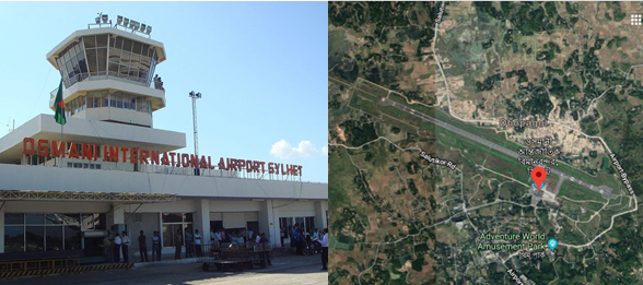
Airport Overview
| Location Details | |||
|---|---|---|---|
| Country | Bangladesh | Latitude | 24.96333 |
| Province / District | Sylhet | Longitude | 91.86694 |
| Town or City (Closest) |
Sylhet 5 NM N of Sylhet Town |
Elevation (ft and m) | 50 ft / 15.24 m |
| Airfield Name | Osmani International Airport | IATA and ICAO Codes | VGSY / ZYL |
| Open From (hours) | 6:00 | Open To (hours) | 21:00 |
Sylhet is a major city in north-eastern Bangladesh. It is the main city of Sylhet Division and District and was granted metropolitan city status in March 2009. Sylhet is located on the banks of the Surma River and is surrounded by the Jaintia, Khasi and Tripura hills. The city is approaching a population of 500,000 people while also having a high population density. It is one of the largest cities in Bangladesh. The Sylhet region is well known for its tea gardens and tropical forests, the city however is currently known for its business boom – being one of the richest cities in Bangladesh, with new investments of hotels, shopping malls and luxury housing estates, brought mainly by expatriates living in the United Kingdom. The city of Sylhet is served by Osmani International Airport, located at the north of the city.
Osmani International Airport, Sylhet was built in 1944-1945, during the 2nd World War to check Japanese aggression from Burma. The airport was formerly known as Sylhet Civil Airport. The airport was initially served by domestic flights from Shahjalal International Airport by the country's national airline Biman Bangladesh Airlines Ltd. After that Sylhet Civil Airport was renamed as Osmani International Airport (OIA) in the honour of General M A G Osmani, the Chief of Liberation Forces of Bangladesh and a proud son of the soil of Sylhet division.
In 1986, the airport became a full-fledged domestic airport after the construction of terminal building, installation of navigational aids, re-construction of runway pavement, development of taxiways and aprons under the project of Sylhet Civil Airport. After many years in 1998 Ltd expansion of the airport was carried out to enable medium-sized aircraft, such as the Airbus A310. In 2002 the airport was designated an International airport by the government, and it received the first international arrival flight of Biman Bangladesh Airlines Ltd. However, the airport was not up to international standards due to shortage of equipment.After the South Asia Transport and Trade Facilitation Conference in 2006, upgradation work of terminal facilities to enable handling of international flights work was started. The improvements included construction of a new terminal building, two Jetways and a taxiway and after the completion of work Biman would operate Hajj flights directly from the airport during the Hajj season in 2007.In 2010 the decision was made to construct a refuelling station and the work began in 2012. In 2015, Fly Dubai the 1st foreign airlines operated their flight to Sylhet from Dubai. Osmani International Airport is located at 15 km north-east from Sylhet city. At present domestic and international passenger and cargo flights are operating by the national and international airlines operators to and from Osmani International Airport, Sylhet. It is one of the most clean and hygienic Airport which is well maintained regularly.
|
Airport Operations Manager |
Custom |
Handling Operations / Logistics |
|---|---|---|
|
Airport Manager Cell: 01708167287 PABX: 880821- 725391 to 94 |
Assistant Commissioner of Customs Airport custom House Tel: 0821- 717356 |
Biman Bangladesh Airlines: |
General Information of OIA
Runway Details
|
Description |
Runway 11 |
Runway 29 |
|---|---|---|
|
Surface |
ASPHALT |
ASPHALT |
|
True Heading |
113.00 |
293.00 |
|
Latitude |
24.968336 and 24° 58' 06.01" N |
24.958147 and 24° 57' 29.33" N |
|
Longitude |
91.853617 and 091° 51' 13.02" E |
91.879953 and 091° 52' 47.83" E |
|
Elevation/Slope |
50.0 feet (15 meters)/0 |
50.0 feet (15 meters)/ 0.0° |
|
Landing Distance |
8458 feet (2578 meters) |
9478 feet (2889 meters) |
|
Take off Distance |
9678 feet (2950 meters) |
9478 feet (2889 meters) |
|
Displaced Threshold Length |
1020 feet (311 meters) |
- |
|
Overrun Length |
200 feet (61 meters) |
- |
|
Overrun Surface |
ASPHALT |
ASPHALT |
|
Lighting System |
PAPI LIGHTS |
PAPI LIGHTS |
|
SWY dimensions |
61x46 m |
300x46 m |
|
CWY dimensions |
153 m |
300 m |
|
Strip dimensions |
2952x153 m |
2952x153 m |
|
SWY surface and strength: First 80FT same as RWY, Remaining 120FT is nominal concrete. |
||
Airfield details
|
Customs (HO) |
Yes |
JET A-1 fuel |
Yes |
|---|---|---|---|
|
Immigration (HO) |
Yes |
AVGAS 100 |
No |
|
Terminal building |
Yes |
Single point refuelling |
No |
|
Passenger terminal |
Yes |
Starter units (press air) |
Yes |
|
Cargo terminal |
No |
Ground power (mobile) |
Yes |
|
Pax transport to airfield |
Yes |
Crash crew |
Yes |
|
Control tower |
Yes |
Aircraft support services |
Yes |
|
Weather facilities |
Yes |
Latrine servicing |
Yes |
|
Catering services |
No |
Fire fighting |
Yes |
|
Base Operating room |
No |
Fire fighting category (ICAO) |
Category: V |
|
Airport radar |
No |
Fire fighting equipment |
Yes |
|
NDB |
Yes |
De-icing equipment |
No |
|
VOR |
Yes |
IFR procedures |
Yes |
|
ILS |
Yes |
Runway lights |
Yes |
|
Approach lights |
Yes |
Parking ramp lighting |
Yes |
Airport Data
|
Geographical and Administration Data |
||
|---|---|---|
|
1. |
ARP* coordinates and site at AD* |
245740.83N, 0915217.89E; in the runway |
|
2. |
Distance and direction from city |
5 NM N/NE of Town |
|
3. |
AD elevation/reference temperature |
Elev: 50ft / T: 35.4 degree C |
|
4. |
Magnetic variation |
50' West |
|
5. |
Type of traffic permitted |
IFR/VFR |
|
*ARP: Aerodrome Reference Point; AD: Aerodrome; APM: Airport Manager |
||
|
Passenger Facilities |
||
|
1. |
Hotels |
Available within 2 km from airport |
|
2. |
Restaurant accommodation |
Ltd at the airport |
|
3. |
Transportation available |
Taxis, Microbus, Car, Autorickshaws |
|
4. |
Medical Facilities |
Only First Aids available |
|
5. |
Banks and Post Office |
Available |
|
6. |
Tourist office |
Available within 2 km from airport |
|
Rescue and Fire Fighting Services |
||
|
1. |
AD category for fire fighting: |
CAT 5, available 5. |
|
2. |
Rescue equipment available: |
Ltd |
|
3. |
Disable Aircraft Removal |
Nil |
|
Seasonal Availability Clearing |
||
|
The airport is available for all seasons. Side strips become unusable during monsoon. There is no requirement for clearing. |
||
|
Aprons, Taxiways and Check Location Data |
||
|---|---|---|
|
1. |
Apron surface and strength |
Surface : Bituminous Concrete. Strength : PCN20/F/C/Y/T. |
|
2. |
Taxiway width, surface and strength |
Width : 35 m. Surface: Bituminous Concrete. Strength : PCN20/F/C/Y/T. |
|
3. |
ACL Location |
Not designated |
Other Airport Data
|
Surface Movement Guidance, Control System and Markings |
||
|---|---|---|
|
1. |
Stand identification/ TWY guidelines/ visual docking/ parking guidance |
Taxiing guidance signs at intersections with TWY and RWY, |
|
2. |
RWY and TWY markings and LGT |
RWY marking aids: THR, Centre Line, RWY designator - all
runways. |
|
3. |
Stop Bars |
N/A |
|
Aerodrome Obstacles |
||||
|---|---|---|---|---|
|
In approach/Take-off areas |
In circling area |
|||
|
Obstacles in approach/ take-off area are shown in Instrument Approach Charts |
RWY affected |
Obstacle type |
Position |
LGT |
|
29 |
Jalalabad Gas Transmission Building. 150 FT (AGL) |
245302.22N 0915249.08E, |
LGT |
|
|
29 |
Flare stack Kailastila Gas Field, 186FT(AGL) |
245208.28N 0920128.02E |
LGT |
|
|
Meteorological Information Provided |
||
|---|---|---|
|
1. |
Associated Met office |
Osmani Intl. Airport (VGSY) |
|
2. |
Hours of service |
HO |
|
3. |
Office responsible for TAF preparation and Periods of validity |
HSIA (VGZR); 6 |
|
4. |
Briefing/consultation provided |
Provided at VGZR |
|
5. |
Flight documentation and Languages used |
C, PL; English |
|
6. |
ATS units provided with information |
TWR |
|
Declared Distances |
|||||
|---|---|---|---|---|---|
|
RWY |
TORA (m) |
TODA (m) |
ASDA (m) |
LDA (m) |
Remarks |
|
11 |
2591 |
2744 |
2652 |
2591 |
N/A |
|
29 |
2591 |
2891 |
2891 |
2591 |
N/A |
|
Abbreviations: RWY: Runway; TORA: Take-off run available; TODA: Take-off
distance available; |
|||||
|
Approach and runway lighting |
|||||||||
|---|---|---|---|---|---|---|---|---|---|
|
RWY designator |
APCH |
THR |
VASIS |
TDZ |
RWY CL |
RWY edge |
END and WBAR |
STWL |
Rem |
|
11 |
Simple approach lighting system |
Six Green LGT |
PAPI |
N/A |
N/A |
60m apart, 79+4=84 lights, intensity 100%, 80%, 60% |
Abvl |
N/A |
N/A |
|
29 |
N/A |
Six Green LGT |
PAPI |
N/A |
N/A |
Abvl |
N/A |
N/A |
|
|
Other Lighting, Secondary Power Supply |
|||
|---|---|---|---|
|
1. |
ABN/IBN location, characteristics and hours of operation |
N/A |
|
|
2. |
LDI location and LGT |
N/A |
|
|
3. |
TWY edge and centre line lighting |
Edge: Available |
|
|
4. |
Secondary Power Supply/ Switchover time |
During main power supply failure, Automatic standby generator power supply available within 15 seconds. |
|
|
5. |
Remarks |
APRON LIGTHS: available |
|
|
ATS Airspace |
|||
|
Designation |
Air Traffic Zone (ATZ) |
||
|
1. |
Lateral limits |
ATZ is oval shaped area joining outer tangents of 5 NM (9 km) radius circles centered at the runway centre and both ends of runway |
|
|
2. |
Vertical limits |
4000 ft (AMSL) |
|
|
3. |
Airspace |
D |
|
|
4. |
Unit Language |
English |
|
|
5. |
Transition altitude |
4000 ft |
|
|
ATS Communication Facilities |
||||
|---|---|---|---|---|
|
Service designator |
Call sign |
Frequency |
Hours of operation |
Remarks |
|
Aerodrome Control Centre |
Sylhet Tower |
122.9 MHz |
HO* |
N/A |
|
*HO: Service available to meet operational requirements |
||||
|
Radio Navigation and Landing Aids |
|||||
|---|---|---|---|---|---|
|
Type |
Ident |
Freq |
OpHr |
Coordinates |
Remarks |
|
DVOR |
SYT |
116.4 MHz |
HO |
245738.97N |
EM:A2 |
|
NDB |
SY |
372 kHz |
HO |
245719.60N |
EM:A0/A2 |
|
ILS/LLZ |
SYL |
110.5 MHz |
HO |
245726.53N |
144 deg MAG, 550m FM THR RWY 32, EM:A2 |
|
ILS/GP |
|
332.6 MHz |
HO |
245800.21N |
Slope: 3 deg, 130 m off-set East, 300 m inward fm RWY 14, RDH 51.57 ft, EM:A3 |
|
DME |
|
1003 MHz |
HO |
245800.21N |
Collocated with GP, |
Yearly Performance
|
Total aircraft movements |
8500-9000 movements yearly |
|---|---|
|
Total passengers |
Approx. 6,00,000 |
|
Current monthly use by Humanitarian flights (UNHAS) |
No regular flight |
Cargo Handling procedure and Storage Facility
At present there is no warehouse or Cargo village as such at this International Airport. Mostly all the cargo are handled manually. No Cargo Handling Equipment is available here as such except few trolley for carrying passenger luggeses. Temporary arrangement can me made for 1000 MT at the transit cargo shed. But there is no proper Cargo storage facility/warehouse as such. Mostly the flights are passenger based and their Luggages are handled by Biman Bangladesh Airlines. Biman has a shed where the Passengers left luggage are laid apart for a max period of 1/2 days. No imported Cargo or exports cargo is handled here. But in case of emergency this Bangladesh Biman shed will be used. In addition, the concrete area infront of VIP lounge is earmarked to be used as temporary cargo storage raising tripol sheds over the area of 15,000 sq ft.
Development Projects
Though it’s an international airport, lot of facilities are required to be arranged/established. Therefore following development programs have been taken in hand:
Recently Completed Development Works
- Installation of Fire Alarm System.
- Modernization of security equipment (Dual view scanning machine, ETD, under vehicle scanning system).
On Going Development Works
- Construction of Security Wall.
- Construction of Security Petrol Road
- Installation of new ILS
- Installation of high capacity sub-station.
Future Development Works
- Improvement of the Runway- The Runway will be further strengthened to raise its PCN from 70 to 90.
- 2nd Terminal - The 2nd Terminal building will be built to be used as proper international terminal.
- Installation of 06 (six) Boarding Bridge.
- Storage and cargo handling capacity will be increased to meet the standard requirement.
- Land requisition for the construction of runway strip as per ICAO standard.
Fueling Arrangement at OIA
Padma Oil Company under the supervision of Bangladesh Petroleum Corporation (BPC) is solely responsible for providing fuel to all kinds of Aircraft at Osmani International Airport. Arrangements are there to support a full fledget International Airport but the present establishment and setup is not being used at the moment. The depot is located within 1 Km of the airport. Few salient features of this Aviation fuel provider are below:
|
Sl |
Description |
Arrangement |
||
|---|---|---|---|---|
|
1 |
Type of Fuel |
Jet A1 |
||
|
2 |
Tanks with Capacity |
03 Tanks with total approx 12,00,000 storage capacity but non in use. |
||
|
3 |
Requisition for Fuel |
Written requisition with Payment be placed in advance. |
||
|
4 |
Hydrant lines |
Approx 1.5 KM Hydrant pipe lines are laid from depot to airport area with 6 fueling points against 4 bay (2 each for 2 bays with Boarding Bridge and One each for 2 other non-BB bays). But these are not yet in use. |
||
|
5 |
Fueling arrangement |
Normally Fueling is done by following refuellers: a. 2X Trailers- 40,000 liters b. 1X Refueller-20,000 liters c. 2X Refueller- 18,500 liters d. 1X Trailers- 30,000 liters Total 1,08,500 liters Jet A-1 is kept as reserve for fueling and its regularly requisitioned from Dhaka. |
||
|
6 |
Consumption |
Yearly approx. 48,00,000 liters |
||
|
7 |
Price of Jet A1 |
BDT 75/00 and $ 0.72 per liter |
||
|
8 |
Manpower |
Total 17 including drivers, security, mechanics, and office staff) |
||
|
9 |
Safety |
Ensured by IATA and JIG |
||
|
10 |
Tech assistance |
Provided by SHELL |
||
|
Contact Details |
Md Hemayet Hossain Assistant Manger (Aviation), Depot In-Charge |
Cell No: 01777703314 |
||
Security Arrangement
- A large security presence exists on the airport with a significant number of airport security personnel.
- Security personnel are under the control of the Airport Manager.
- A dedicated police Camp exists within the airport premise.
- All access points are guarded by security personnel.
- Temporary passes can be issued to airside workers within 30 minutes upon the directive of the NDMA.
- X-Ray screening for both passengers and cargo is in use.
For information on Bangladesh Osmani International Airport additional information, please see the following documents:
Bangladesh Airports additional info
Bangladesh Costs 2013 Airfield Charges
Bangladesh Common Information Airport Charges
Bangladesh Osmani
airport additional info
Note: The information provided in the attached documents, which has been taken from the old DLCA, does not match the structure of the new LCA and is therefore provided separately.
For information on Bangladesh Osmani International Airport contact details, please see the following link:
4.5 Bangladesh Airport Contact List
Information on some aviation service providers can be found at: AZ Freight information on Bangladesh
2.2.4 Bangladesh Saidpur Airport
Saidpur Airport started its journey as a domestic airport in 1979. This airport is situated on a total of 136.59 acres of land. Saidpur Airport is managed by the Civil Aviation Authority of Bangladesh. This Airport is located at 2 km from Saidpur town and 350 km from Dhaka. The only destination is Dhaka for the Passengers. 4 domestic airlines (Bangladesh Biman, Novo Air, US Bangla and Regent Airways) are presently operating their passenger flights from and to Saidpur Airport.
|
Facilities Available |
Car Parking, Passenger Lounge, Pure Drinking Water, Wheelchair, First Aid, Pure Drinking Water, Prayer Room, Wi-Fi and Help Line |
|
|---|---|---|
| NO | Warehouse, Refuelling, Repairing and Handling Equipment. | |
|
Airport Manager, Saidpur, Bangladesh |
Telephone: +880552672384, Cell: 01708167307 |
|
General Information
|
ICAO ID |
VGSD |
Time |
UTC+6 |
|---|---|---|---|
|
Latitude |
25.759228 (25° 45' 33.22" N) |
Longitude |
88.908869 (088° 54' 31.93" E) |
|
Elevation |
125 feet (38 meters) |
Type |
Commercial (Domestic) |
|
Magnetic Variation |
000° W (05/06) |
Operating Agency |
CAAB |
|
Runways |
||||||
|---|---|---|---|---|---|---|
|
ID |
Dimensions |
Surface |
PCN |
ILS |
||
|
16/34 |
6000 x 100 feet (1829 x 30 meters) |
ASPHALT |
017FCYT |
NO |
||
|
Description |
Runway 17 |
Runway 34 |
||||
|
Surface |
ASPHALT |
ASPHALT |
||||
|
True Heading |
1.600 |
3.400 |
||||
|
Latitude |
25.766958 (25° 46' 01.05" N) |
25.751497 (25° 45' 05.39" N) |
||||
|
Longitude |
88.905689 (088° 54' 20.48" E) |
88.912053 (088° 54' 43.39" E) |
||||
|
Elevation |
125.0 feet (38 meters) |
125.0 feet (38 meters) |
||||
|
Slope |
0.0° |
0.0° |
||||
|
Landing Distance |
6000 feet (1829 meters) |
6000 feet (1829 meters) |
||||
|
Takeoff Distance |
6394 feet (1949 meters) |
6394 feet (1949 meters) |
||||
|
Overrun Length |
394 feet (120 meters) |
394 feet (120 meters) |
||||
|
Lighting System |
V LIGHTS |
V LIGHTS |
||||
For information on Bangladesh Airport additional information, please see the following documents:
Bangladesh Common Information Airport Charges
Bangladesh Airports additional info
Bangladesh Costs 2013 Airfield Charges
Note: The information provided in the attached documents, which has been taken from the old DLCA, does not match the structure of the new LCA and is therefore provided separately.
For information on Bangladesh Airport contact details, please see the following link:
4.5 Bangladesh Airport Contact List
2.2.5 Bangladesh Shah Makhdum Airport
Shah Makhdum airport is a domestic airport situated at the northwestern side of the country. It is about 10 km North of the Rajshahi city and beside Rajshahi-Nowgon highway. Now three Passenger flights (Biman Bangladesh Airlines, Novo Air and US-Bangla Airlines and Two Aviation Academy) are operating in this Airport. Two Aviation Academy (Pilot training school) are running here. They have six/ seven training Aircraft those are operating from this Airport. Besides this domestic cargo flights are also operating to and from different destination at Shah Makhdum Airport. Facilities available are:
- Airconditioned waiting lounge
- Free Wi-Fi facilities
- Canteen Facilities
- Given flight information by PA system
- Separate smoking zone and prayer room
- Supply of cold and hot water as required
|
Airport Manager Shah Makhdum Airport, Rajshahi |
Phone: +880 2 47800053 (Off), Cell: +880 1708167303, +880 1556300056 e-mail: apmrajshahi@caab.gov.bd |
General Information
|
ICAO ID |
VGRJ |
Time |
UTC+6 |
|---|---|---|---|
|
Latitude |
24.437219 (24° 26' 13.99" N) |
Longitude |
88.616511 (088° 36' 59.44" E) |
|
Elevation |
64 feet (20 meters) |
Magnetic Variation |
000° W (05/06) |
|
Operating Agency |
CAAB (LANDING FEES AND DIPLOMATIC CLEARANCE MAY BE REQUIRED) |
||
|
Runways |
||||||
|---|---|---|---|---|---|---|
|
ID |
Dimensions |
Surface |
PCN |
ILS |
||
|
6000 x 100 feet (1829 x 30 meters) |
ASPHALT |
017RCYT |
NO |
|||
|
Description |
Runway 17 |
Runway 35 |
||||
|
Surface |
ASPHALT |
ASPHALT |
||||
|
True Heading |
1.700 |
3.500 |
||||
|
Latitude |
24.445333 (24° 26' 43.20" N) |
24.429103 (24° 25' 44.77" N) |
||||
|
Longitude |
88.614961 (088° 36' 53.86" E) |
88.618064 (088° 37' 05.03" E) |
||||
|
Elevation |
55.0 feet (17 meters) |
55.0 feet (17 meters) |
||||
|
Landing Distance |
6000 feet (1829 meters) |
6000 feet (1829 meters) |
||||
|
Takeoff Distance |
6200 feet (1890 meters) |
6400 feet (1951 meters) |
||||
|
Overrun Length |
200 feet (61 meters) |
400 feet (122 meters) |
||||
|
Overrun Surface |
ASPHALT |
ASPHALT |
||||
|
Lighting System |
V LIGHTS |
V LIGHTS |
||||
Bangladesh Common Information Airport Charges
Bangladesh Airports additional info
Bangladesh Costs 2013 Airfield Charges
Note: The information provided in the attached documents, which has been taken from the old DLCA, does not match the structure of the new LCA and is therefore provided separately.
For information on Bangladesh Airport contact details, please see the following link:
2.2.6 Bangladesh Jessore Airport
During the 2nd World War the British Government constructed an air base in Jashore for British Air Force. In 1945 the air base was in operation. In 1950, the Pakistan Army and Air Force base was established. In 1956, initiatives were taken to start a full airport in Jashore and completed in 1960. The airport is operated by the Civil Aviation Authority of Bangladesh, but it is also used by the Bangladesh Air Force as a part of BAF Matiur Rahman Base and training airfield for Bangladesh Air Force Academy.
This airport is located at 7 km north of Jashore city and 140 km south-west from Dhaka, the capital city of Bangladesh.
The only destination is Dhaka for the passengers. Four airlines (Biman Bangladesh Airlines, Novo Air, United Airways and US-Bangla Airlines) are presently operating their passenger flights in Jashore-Dhaka-Jashore route. Besides this domestic cargo flights are also operating to and from different destination at Jashore airport. Following are the available facilities:
- Car parking facility
- Drinking water
- Baggage scanning
- VIP/ CIP lounges
- Passenger lounge
- Ramp and wheelchair facilities
- Sanitation facilities
- Free Wi-Fi
- TV
|
Airport Manager, Jashore |
Tel: +880 421 64033, Cell: +880 1708167298, Tower: +880 421 65032, e-mail : apmJashore@caab.gov.bd |
General Information
|
ICAO ID |
VGJR |
Time |
UTC+6 |
|---|---|---|---|
|
Latitude |
23.183800 (23° 11' 01.68" N) |
Longitude |
89.160833 (089° 09' 39.00" E) |
|
Elevation |
20 feet (6 meters) |
Magnetic Variation |
000° W (05/06) |
|
Operating Agency |
MILITARY - CIVIL JOINT USE AIRPORT |
||
|
Runways |
||||||
|---|---|---|---|---|---|---|
|
ID |
Dimensions |
Surface |
PCN |
ILS |
||
|
8000 x 150 feet (2438 x 46 meters) |
ASPHALT |
018FCYT |
NO |
|||
|
Description |
Runway 16 |
Runway 34 |
||||
|
Surface |
ASPHALT |
ASPHALT |
||||
|
True Heading |
1.580 |
3.380 |
||||
|
Latitude |
23.193833 (23° 11' 37.80" N) |
23.173767 (23° 10' 25.56" N) |
||||
|
Longitude |
89.156333 (089° 09' 22.80" E) |
89.165333 (089° 09' 55.20" E) |
||||
|
Elevation |
20.0 feet (6 meters) |
20.0 feet (6 meters) |
||||
|
Slope |
0.0° |
0.0° |
||||
|
Landing Distance |
8000 feet (2438 meters) |
8000 feet (2438 meters) |
||||
|
Takeoff Distance |
8485 feet (2586 meters) |
8318 feet (2535 meters) |
||||
|
Overrun Length |
485 feet (148 meters) |
318 feet (97 meters) |
||||
|
Overrun Surface |
ASPHALT |
ASPHALT |
||||
|
Lighting System |
PAPI LIGHTS |
PAPI LIGHTS |
||||
Bangladesh Common Information Airport Charges
Bangladesh Airports additional info
Bangladesh Costs 2013 Airfield Charges
Note: The information provided in the attached documents, which has been taken from the old DLCA, does not match the structure of the new LCA and is therefore provided separately.
For information on Bangladesh Airport contact details, please see the following link:
2.2.7 Bangladesh Barisal Airport
In 1963-64 the Plant Protection Department acquired 13.09 acres land to spray pesticides by aircraft and made an airstrip sized 1800'-0" x 60'-0". Later 1970-71 by the order from the government The Department of Civil Aviation acquired more 85.46 acres land for the purpose of launching an airport in the south but after the acquisition it was closed.
In 1990-91 the construction work of the airport was started. After completing the work of runway (2300'-0" x 100'-0") in July 1995, Civil Aviation Authority of Bangladesh was able to open a stall-port (current "Barisal Airport") for executing commercial aircraft. At present runway 6000'-0" x 100'-0" is available. A number of airlines started its passenger flights but again closed after few months because this route is not viable for airlines business but this airport is capable of handling any type of domestic aircraft like other domestic airports. Barisal airport may be used in time of any disaster, as it was the case during Cyclone Sidr emergency operations in 2007 when it become a logistics hub as well as an operational coordination center. Facilities available are:
- Car parking
- Drinking water
- VIP/CIP Lounges
- Wheel chair facilities
- Free Wi-Fi
|
Airport Manager, Barisal |
Phone: +880 4327 73362 (Off), Cell: +880 01708167315, Fax : +880 4327 73362, email : apmbarisal @caab.gov.bd |
General Information
|
ICAO ID |
VGBR |
Time |
UTC+6 |
|---|---|---|---|
|
Latitude |
22.801031 (22° 48' 03.71" N) |
Longitude |
90.301164 (090° 18' 04.19" E) |
|
Elevation |
23 feet (7 meters) |
Magnetic Variation |
000° W (05/06) |
|
Operating Agency |
CAAB, (Landing Fees and Diplomatic Clearance May be Required) |
||
|
Runways |
||||||
|---|---|---|---|---|---|---|
|
ID |
Dimensions |
Surface |
PCN |
ILS |
||
|
5995 x 100 feet (1827 x 30 meters) |
Asphalt |
017RCYT |
NO |
|||
|
Description |
Runway 17 |
Runway 35 |
||||
|
Surface |
Asphalt |
Asphalt |
||||
|
True Heading |
1.740 |
3.540 |
||||
|
Latitude |
22.809236 (22° 48' 33.25" N) |
22.792828 (22° 47' 34.18" N) |
||||
|
Longitude |
90.300219 (090° 18' 00.79" E) |
90.302108 (090° 18' 07.59" E) |
||||
|
Elevation |
10.0 feet (3 meters) |
10.0 feet (3 meters) |
||||
|
Landing Distance |
5995 feet (1827 meters) |
5995 feet (1827 meters) |
||||
|
Takeoff Distance |
6195 feet (1888 meters) |
6160 feet (1878 meters) |
||||
|
Overrun Length |
200 feet (61 meters) |
165 feet (50 meters) |
||||
|
Overrun Surface |
Asphalt |
Asphalt |
||||
|
Lighting System |
PAPI |
PAPI |
||||
Bangladesh Common
Information Airport Charges
Bangladesh Airports additional info
Bangladesh Costs 2013 Airfield Charges
Note: The information provided in the attached documents, which has been taken from the old DLCA, does not match the structure of the new LCA and is therefore provided separately.
For contact details, please see the following link:
2.2.8 Bangladesh Cox's Bazar Airport
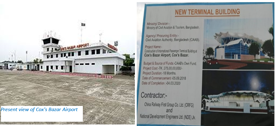
General Information
|
ICAO ID |
VGCB |
Time |
UTC+6 |
|---|---|---|---|
|
Latitude |
21.452194 (21° 27' 07.90" N) |
Longitude |
91.963889 (091° 57' 50.00" E) |
|
Elevation |
12 feet (4 meters) |
Magnetic Variation |
000° W (05/06) |
|
Operating Agency |
CAAB (Landing Fees and Diplomatic Clearance May be Required) |
||
|
Ground handling |
No equipment is available now. Only few hand trolleys and Ladder are available which are again arranged by the individual operators. |
||
|
Immigration |
- |
||
|
Fuelling |
Standard Asiatic Oil Ltd has been entrusted with the responsivity of proving Fuel to all the visiting aircrafts. At present they have 3 Fuel tanks with capacity of total 1,00,000 Ltr. They are located at the Airport vicinity and have 2 Refuellers to provide fuel to the aircrafts. They have 15 personnel at Cox’s Bazar (Contact Mr Nazmul, Manager-01715313454). |
||
|
Storage Capacity |
Nil, but the concrete parking area can be used for emergency purpose by raising temporary sheds over an area of approx. 45,000 sq ft. |
||
|
Operation Hours |
08:00 AM to 17:00 PM |
||
|
Man power |
Total 150 (CAAB-70+Attached-30+Project-50) |
||
|
Security arrangement |
Construction works are going on, so no fool-proof boundary wall is there. Own security personnel and Ansar is looking after the security of Airport. |
||
Cox's Bazar Airport started as a domestic airport in 1956. Due to the damage of the airport during liberation war in 1971, Cox's Bazar Airport was re-opened as a domestic airport at the end of 1971. This airport is situated on 941 acres of land. Cox's Bazar Airport is managed by the Civil Aviation Authority of Bangladesh. The airport is located 1.5 kilometres from Cox's Bazar City and 396km from Dhaka. This Airport operates only Cox’s Bazar- Dhaka passenger flights, but recently there is a flight between Cox’s Bazar and Chattogram twice a week. Ffour airlines are operating their passenger flights from and to Cox's Bazar Airport.
- Biman Bangladesh Airlines Ltd
- Novo Air Ltd
- Us Bangla Airlines Ltd
- Regent Airways Ltd
And following five cargo flights are operating their flights from Cox's Bazar Airport to Jashore for carrying fish fries.
- Sky Capital Airlines Ltd (3 FSO B737's)
- Bismillah Airlines Ltd (operating 2 aircraft; one AN28 and one HS-740)
- True Aviation Ltd (one AN26)
- Easy air Ltd (one SAAB 340).
Following facilities are available at the airport:
- Car parking
- Drinking water
- VIP/CIP Lounges
- Ramp and wheel chair facilities.
- Free Wi-Fi service
|
Md Abdullah Faruk Airport Manager, Cox's Bazar, Bangladesh. |
Cell: 01708167294, Telephone: +880341-52353, +880341-64479, Email: apmcox@caab.gov.bd TWR: +880341-62010 |
|
Runways |
||||||
|---|---|---|---|---|---|---|
|
ID |
Dimensions |
Surface |
PCN |
ILS |
||
|
9000 x 125 feet (2743 x 38 meters) |
Bituminous Concrete |
63/R/C/W/T |
NO |
|||
|
Description |
Runway 17 |
Runway 35 |
||||
|
Surface |
Bituminous concrete |
Bituminous concrete |
||||
|
True Heading |
1.690 |
3.490 |
||||
|
Latitude |
21.461336 (21° 27' 40.81" N) |
21.443056 (21° 26' 35.00" N) |
||||
|
Longitude |
91.962044 (091° 57' 43.36" E) |
91.965731 (091° 57' 56.63" E) |
||||
|
Elevation |
12.0 feet (4 meters) |
12.0 feet (4 meters) |
||||
|
Landing Distance |
8860 feet (2700 meters) |
8860 feet (2700 meters) |
||||
|
Takeoff Distance |
9500 feet (2895 meters) |
9500 feet (2895 meters) |
||||
|
Overrun Length |
460 feet (140 meters) |
490 feet (149 meters) |
||||
Future Development
Considering the importance and traffic at the present scenario the government has decided to expand and upgrade the Cox’s Bazar Airport to an international airport, its 2nd largest. Development works are going on and the new terminal building is expected to be completed by 2020. To promote Cox's Bazar Airport as International Airport, a project called Cox's Bazar Airport Development Project is in progress. Following works are being carried out under the project:
- Increase the runway length from 9,000 feet to 10,000 feet.
- Establishment of Airfield Ground Lighting System
- Purchase of firefighting vehicle
- ILS, DVOR, DME, FIDS, PA system etc.
- Construction of new terminal building on-going
Cox’s Bazar international airport is a huge proposed project by the government handled by the civil aviation authority of Bangladesh to provide the international standard facilities to the incoming passengers. Due to the geographical location and tourism characteristic of the area there is a continued air traffic growth that encourages Cox’s Bazar International Airport to be design more appropriately and equipped with better facilities. Beside the above ongoing development works, a master plan has been taken in hand to make this airport a modern international airport by 2030. As per this master plan total land over the area west of the existing runway till seashore is being acquisitioned. Necessary earth filling works is in progress to expand the runway up to 10,000 feet. The settlers of that area will be rehabilitated in a suitable area by the government.
For additional information, please see the following documents:
Bangladesh Common Information Airport Charges
Bangladesh Airports additional info
Bangladesh Costs 2013 Airfield Charges
Note: The information provided in the attached documents, which has been taken from the old DLCA, does not match the structure of the new LCA and is therefore provided separately.
For contact details, please see the following link:
2.2.9 Bangladesh Thakuragaon Airport
|
Airport Details |
|||
|---|---|---|---|
|
Country |
Bangladesh |
Latitude |
26° 2’ 0” N |
|
Province / District |
N/A |
Longitude |
88° 28’ 0” E |
|
Airport Name |
Thakuragaon Airport |
Elevation (ft) |
N/A |
|
IATA & ICAO codes |
TKR / VGSG |
Surface |
N/A |
|
Town or City (closest) |
Thakurgaon |
Runway Condition |
N/A |
|
NGO / UN (on ground) |
N/A |
Passenger / Cargo Security Screening (Yes / No) |
N/A |
|
Runway Dimension |
N/A |
Ground Handling (Yes / No) |
N/A |
|
Refueling Capacity |
N/A |
Runway Lighting (Yes / No) |
N/A |
|
Runway Heading |
N/A |
Fire Fighting Equipment (Yes / No) |
N/A |
|
Air Traffic Control (Yes / No) |
N/A |
Windsock (Yes / No) |
N/A |
|
Weather Information (Yes / No) |
N/A |
Aircraft Parking space (Yes / No) |
N/A |
|
Navigation Aids (Yes / No) |
N/A |
Perimeter fencing (Yes / No) |
N/A |
For additional information, please see the following documents:
Bangladesh Common Information Airport Charges
Bangladesh Airports additional info
Bangladesh Costs 2013 Airfield Charges
Note: The information provided in the attached documents, which has been taken from the old DLCA, does not match the structure of the new LCA and is therefore provided separately.
For contact details, please see the following link:
2.2.10 Bangladesh Ishurdi Airport
|
Airport Details |
|||
|---|---|---|---|
|
Country |
Bangladesh |
Latitude |
24.158347 / N 24° 09' 30.05" |
|
Province / District |
N/A |
Longitude |
24.158347 / N 24° 09' 30.05" |
|
Airport Name |
Ishurdi Airport |
Elevation (ft) |
N/A |
|
IATA & ICAO codes |
IRD / VGIS |
Surface |
Asphalt |
|
Town or City (closest) |
Ishurdi |
Runway Condition |
N/A |
|
NGO / UN (on ground) |
N/A |
Passenger / Cargo Security Screening (Yes / No) |
N/A |
|
Runway Dimension |
1432.6m x 24.4 |
Ground Handling (Yes / No) |
N/A |
|
Refueling Capacity |
N/A |
Runway Lighting (Yes / No) |
N/A |
|
Runway Heading |
N/A |
Fire Fighting Equipment (Yes / No) |
N/A |
|
Air Traffic Control (Yes / No) |
N/A |
Windsock (Yes / No) |
N/A |
|
Weather Information (Yes / No) |
N/A |
Aircraft Parking space (Yes / No) |
N/A |
|
Navigation Aids (Yes / No) |
N/A |
Perimeter fencing (Yes / No) |
N/A |
For additional information, please see the following documents:
Bangladesh Common Information Airport Charges
Bangladesh Airports additional info
Bangladesh Costs 2013 Airfield Charges
Note: The information provided in the attached documents, which has been taken from the old DLCA, does not match the structure of the new LCA and is therefore provided separately.
For contact details, please see the following link:
2.2.11 Bangladesh Shamshernagar Airport
|
Airport Details |
|||
|---|---|---|---|
|
Country |
Bangladesh |
Latitude |
24.39861 |
|
Province / District |
Shamshernagar |
Longitude |
91.92111 |
|
Airport Name |
Shamshernagar Airport |
Elevation (ft) |
N/A |
|
IATA & ICAO codes |
RJH / VGSH |
Surface |
Asphalt |
|
Town or City (closest) |
N/A |
Runway Condition |
N/A |
|
NGO / UN (on ground) |
N/A |
Passenger / Cargo Security Screening (Yes / No) |
N/A |
|
Runway Dimension |
1,650 m |
Ground Handling (Yes / No) |
N/A |
|
Refueling Capacity |
N/A |
Runway Lighting (Yes / No) |
N/A |
|
Runway Heading |
N/A |
Fire Fighting Equipment (Yes / No) |
N/A |
|
Air Traffic Control (Yes / No) |
N/A |
Windsock (Yes / No) |
N/A |
|
Weather Information (Yes / No) |
N/A |
Aircraft Parking space (Yes / No) |
N/A |
|
Navigation Aids (Yes / No) |
N/A |
Perimeter fencing (Yes / No) |
N/A |
For additional information, please see the following documents:
Bangladesh Common Information Airport Charges
Bangladesh Airports additional info
Bangladesh Costs 2013 Airfield Charges
Note: The information provided in the attached documents, which has been taken from the old DLCA, does not match the structure of the new LCA and is therefore provided separately.
For contact details, please see the following link:
2.2.12 Bangladesh Tejgaon Airport
Tejgaon Airport in Dhaka served as the country's sole international airport prior to the construction of Shahjalal International Airport. Following the transfer of civilian flights to the newly built Shahjalal International Airport in 1981, Tejgaon was taken under the control of the Bangladesh Air Force.
It is probable that Tejgaon Airport will be an important operational base for air relief operations (as it was during Cyclone Sidr emergency operations in 2007) for the Armed Forces Division and the Air Force and the other Bangladesh Defense Forces. The compound includes all necessary facilities (storage capacities, operational rooms, etc.) as well as significant areas for open storage and/or setting up Mobile Storage Units (MSU's).
General Information
|
ICAO ID |
VGTJ |
Time |
UTC+6 |
|---|---|---|---|
|
Latitude |
23.778783 (23° 46' 43.62" N) |
Longitude |
90.382689 (090° 22' 57.68" E) |
|
Elevation |
24 feet (7 meters) |
Type |
Military |
|
Magnetic Variation |
000° W (05/06) |
Operating Agency |
Military |
|
Runways |
|||||
|---|---|---|---|---|---|
|
ID |
Dimensions |
Surface |
PCN |
ILS |
|
|
9315 x 98 feet (2839 x 30 meters) |
Asphalt |
012FCYT |
NO |
||
|
Description |
Runway 17 |
Runway 35 |
|||
|
Surface |
Asphalt |
Asphalt |
|||
|
True Heading |
1.640 |
3.440 |
|||
|
Latitude |
23.791131 (23° 47' 28.07" N) |
23.766436 (23° 45' 59.17" N) |
|||
|
Longitude |
90.378953 (090° 22' 44.23" E) |
90.386422 (090° 23' 11.12" E) |
|||
|
Landing Distance |
7530 feet (2295 meters) |
8310 feet (2533 meters) |
|||
|
Takeoff Distance |
9315 feet (2839 meters) |
9315 feet (2839 meters) |
|||
|
Displaced Threshold Length |
1785 feet (544 meters) |
1005 feet (306 meters) |
|||
Bangladesh Common Information Airport Charges
Bangladesh Airports additional info
Bangladesh Costs 2013 Airfield Charges
Note: The information provided in the attached documents, which has been taken from the old DLCA, does not match the structure of the new LCA and is therefore provided separately.
For contact details, please see the following link:
2.2.13 Bangladesh Comilla Airport
|
Airport Details |
|||
|---|---|---|---|
|
Country |
Bangladesh |
Latitude |
23.43681 |
|
Province / District |
N/A |
Longitude |
91.18986 |
|
Airport Name |
Comilla Airport |
Elevation (ft) |
N/A |
|
IATA & ICAO codes |
CLA / - |
Surface |
N/A |
|
Town or City (closest) |
Comilla |
Runway Condition |
N/A |
|
NGO / UN (on ground) |
N/A |
Passenger / Cargo Security Screening (Yes / No) |
N/A |
|
Runway Dimension |
1.650m x n/a |
Ground Handling (Yes / No) |
N/A |
|
Refueling Capacity |
N/A |
Runway Lighting (Yes / No) |
N/A |
|
Runway Heading |
N/A |
Fire Fighting Equipment (Yes / No) |
N/A |
|
Air Traffic Control (Yes / No) |
N/A |
Windsock (Yes / No) |
N/A |
|
Weather Information (Yes / No) |
N/A |
Aircraft Parking space (Yes / No) |
N/A |
|
Navigation Aids (Yes / No) |
N/A |
Perimeter fencing (Yes / No) |
N/A |
For additional information, please see the following documents:
Bangladesh Common Information Airport Charges
Bangladesh Airports additional info
Bangladesh Costs 2013 Airfield Charges
Note: The information provided in the attached documents, which has been taken from the old DLCA, does not match the structure of the new LCA and is therefore provided separately.
For contact details, please see the following link: