Lebanon - 2 Logistics Infrastructure
Lebanon's logistical infrastructure had been struggling due to several factors, including political instability, economic crisis, and the devastating explosion in the port of Beirut in August 2020. Here are some key points about Lebanon's logistical infrastructure at that time:
- Ports: The Port of Beirut was the main gateway for imports and exports in Lebanon. However, after the massive explosion, the port's operations were severely impacted, leading to disruptions in the supply chain and increased transportation costs. The explosion caused damage to storage facilities, cranes, and infrastructure, hindering the flow of goods. Tripoli port came into the light more after the explosion in beirut port with some shipping routes shifting from Beirut to Tripoli.
- Roads and Highways: Lebanon's road network, especially in urban areas, suffer from congestion and inadequate maintenance. Traffic jams are common, affecting the timely movement of goods and people. Additionally, limited funding for road repairs and expansions had been an issue for a long period of time.
- Airports: The Beirut-Rafic Hariri International Airport is the primary international gateway for passenger and cargo traffic. However, ongoing political and economic crises had impacted air travel, leading to reduced flights and potential delays. The airport faced total power outage on several occasions.
- Border Crossings: Lebanon's land borders with neighboring countries facilitated the movement of goods in and out of the country. However, geopolitical issues and regional conflicts could occasionally affect cross-border trade.
- Energy Supply: Lebanon faced frequent power outages and a shortage of fuel, affecting transportation and logistics operations. These power cuts impacted the operations of warehouses, transportation companies, and businesses that relied on a stable energy supply.
Lebanon - 2.1 Port Assessment
Port Assessment
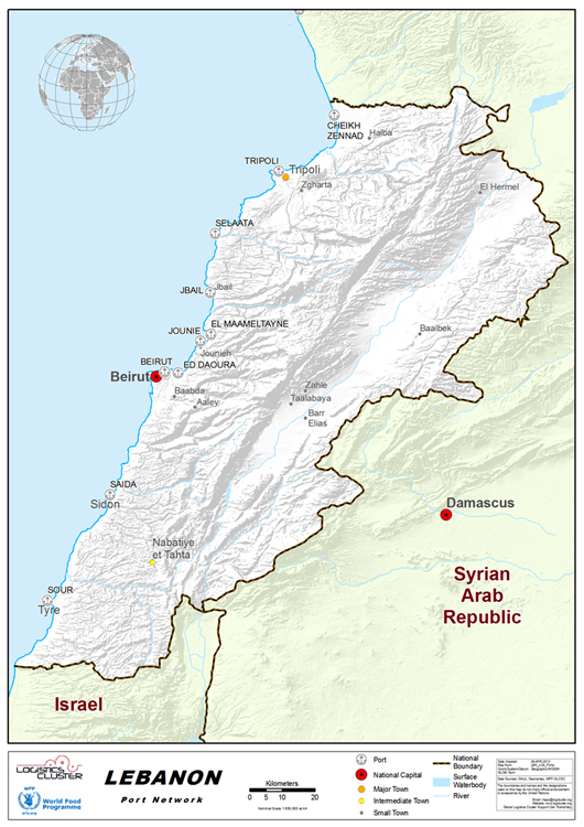
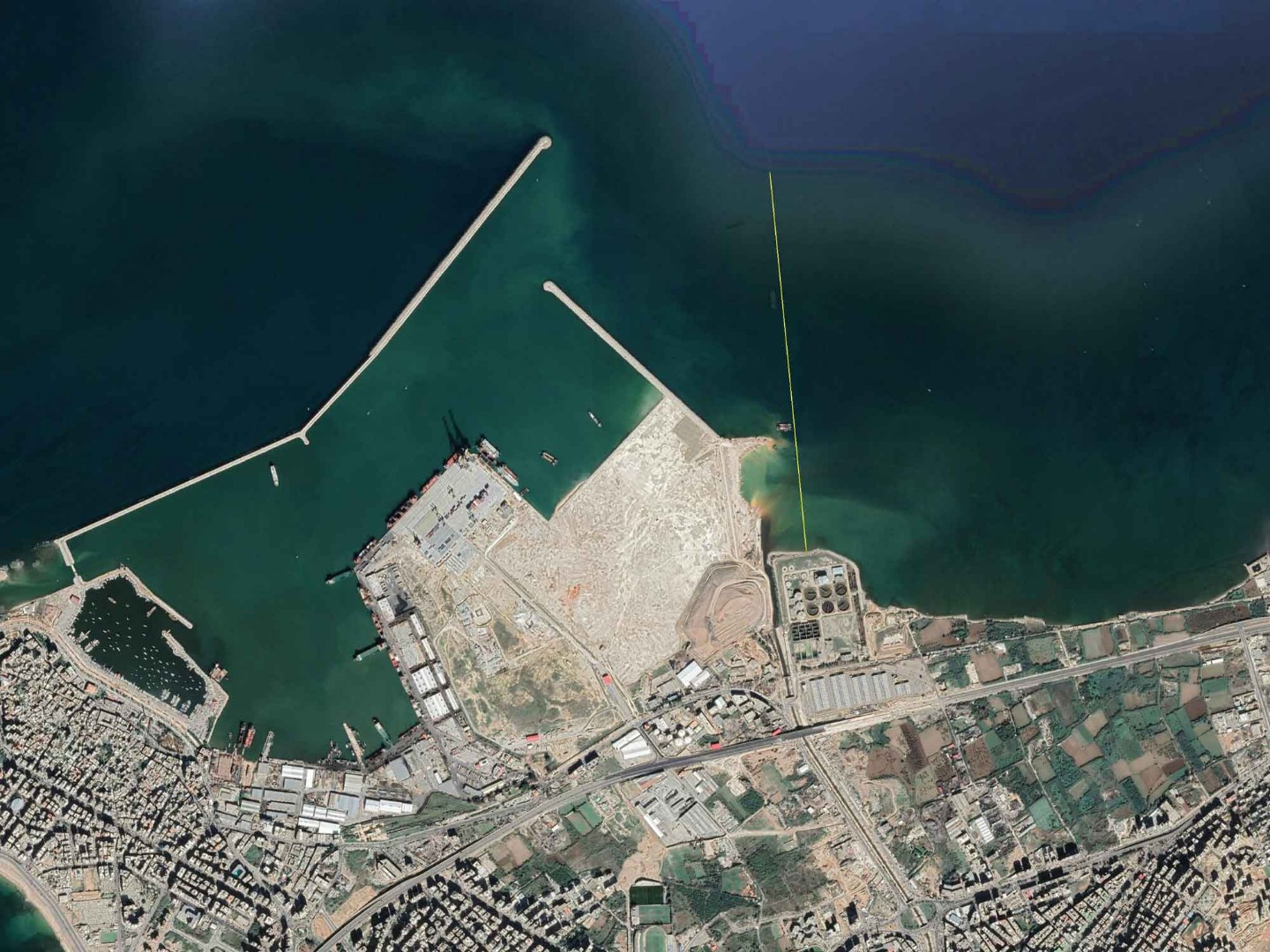
The Port of Beirut is the main port in Lebanon located in the capital city, Beirut, and is one of the largest ports on the Eastern Mediterranean. It has been selected as a transshipment hub for MSC and CMA-CGM. However, after 2020 massive explosion the port's operations were severely impacted. The explosion caused damage to storage facilities, cranes, and infrastructure, hindering the flow of goods.
The Port of Tripoli is the second port in Lebanon after the Port of Beirut. The Port is currently undergoing expansion projects. The port is located 30 km away from the border with Syria. After the 2020 explosion in Beirut port, Tripoli port witnessed an increase in the flow of goods.
Lebanon - 2.1.1 Port of Beirut
Port Overview
The Port of Beirut is Lebanon's main sea port, and it is one of the busiest ports in the Eastern Mediterranean region. The Port of Beirut and the Beirut Rafic Hariri International Airport are Lebanon's main points of entry.
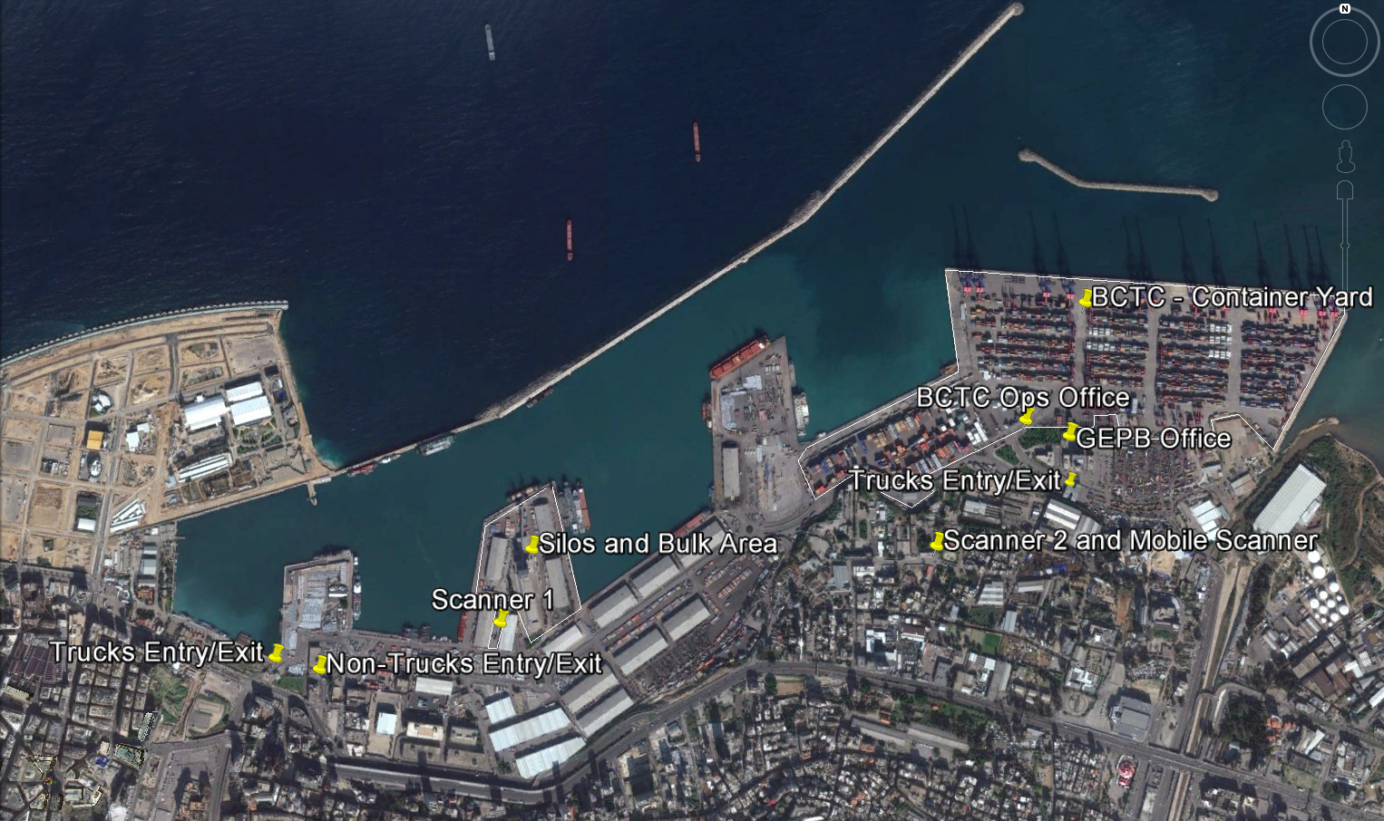
The Port of Beirut consists of a General Cargo Terminal, a Container Terminal, a Passenger Terminal, a Free Zone and a Silo area. The Free zone and Silo were hugely affected by the explosion that occurred in Beirut port during Aug 2020.
The total area of Beirut Port is of 1,200,000 m², with a water basin total area of 1,202,000 m² (including the Container Terminal), a main breakwater of 3,190 m and a detached breakwater of 550 m
Port website: http://www.portdebeyrouth.com/index.php/en/
Key port information may also be found at: http://www.maritime-database.com
|
Port Location and Contact |
|
|---|---|
|
Country |
Lebanon |
|
Province or District |
Beirut |
|
Nearest Town or City with Distance from Port |
Beirut (Capital of Lebanon) |
|
Port's Complete Name |
Port de Beyrouth |
|
Latitude |
33.905000 N |
|
Longitude |
35.521111 E |
|
Managing Company or Port Authority |
Gestion et exploitation du port de Beyrouth (GEPB) |
|
Management Contact Person |
Mr Omar Itani +961 1 58 02 11 till 16 |
|
Nearest Airport and Airlines with Frequent International Arrivals/Departures |
Beirut Rafic Hariri International Airport |
Port Picture
Description and Contacts of Key Companies
- Mediterranean Shipping Company - MSC
- Metz Shipping Agency ltd
- National Shipping Co.
- Sea Line
- Seamen International
- Geazairi Transport
- Company Maritime d'Affretement Agency - CMA
- Merit Shipping
- Maersk Lebanon
- Edouard Cordahi
- Costa Bitar Transport Company
- Akak Marine Cie
- J.B. Shipping Services
- Fast Agency
- Eurabia Intercontinental
- Kawar & Khayat Shipping Agency
- Sea Freight
- Continental Shipping Agency
- Georges Abou Hamad
- H.Heald and Cie
- Gevo Maritime & Transport
- Tourisme & Shipping services
- Carapiperis
- Med Conro Shipping services
- Lebanese Shipping Union
- Hanna Najib Tabet
- Ademar Shipping Lines
- Gulf Agency
- Nicolas Abou Rjeily
- Halim-Roukoz Shipping Agency
- United Navigation Cie
- Abdul Hamid EL Fil & Co.
- Lotus Shipping Agencies SAL
- Pelican International Services
- Barwil Agencies Lebanon SAL
- ETS.PAUL ADEM
- The Levant Shipping Agency
- Gharib Shipping Agency
- Seachart Marine S.A.R.L.
- SALEH SHIPPING
- T. Gargour & Fils SAL
- Ghassan Soubra
- Ultra Maritime Services SARL
- Middle East Transport Company Metco sal
- Blue Wave Shipping sarl
Port Performance
Beirut Port received nearly 2,132 vessels in 2019. In addition, via its container terminal, the port handled 1,229,081 TUEs/year. The port has a channel draft of 16.5 m. A bottleneck in beirut port is the congestion of trucks at entrance and exit gates. WFP has a special agreement, for extending of grace period of all food assistance shipments, from 9 days to 30 days.
|
Seasonal Constraints |
||
|---|---|---|
|
Occurs |
Time Frame |
|
|
Rainy Season |
YES |
October to March/April |
|
Major Import Campaigns |
NO |
|
|
Handling Figures for 2019 |
|
|---|---|
|
Vessel Calls |
2,132 |
|
Container Traffic (TEUs) |
1,229,081 |
|
Handling Figures Bulk and Break Bulk for 2018 |
|
|---|---|
|
Bulkand Break Bulk (MT) |
8,660,600 |
Discharge Rates and Terminal Handling Charges
For information on port rates and charges, please see the following link:
https://www.portdebeyrouth.com/index.php/en/tariffs/port-tariffs
Berthing Specifications
|
Type of Berth |
Quantity |
Length (m) |
Maximum Draft (m) |
Comments |
|---|---|---|---|---|
|
Conventional Berth |
7 |
1,654 |
8 to 10.5 |
|
|
Container Berth |
4 |
1,100 |
15.5 to 16.5 |
|
|
2 |
1,334 |
10.5 to 13 |
|
|
|
1 |
500 |
16.5 |
|
|
|
Silo Berth |
1 |
220 |
13 |
|
|
Berthing Tugs |
2 |
|
||
|
Water Barges |
n/a |
n/a |
n/a |
|
Most container traffic is handled by berth 16 as it can take the biggest container ships. It spans over 36.5 hectares and handles 750,000 TEUs annually. Small ships are handled at berths 12, 13 and 14. Before Beirut Explosion in Aug 2020 the Silo the Silo Terminal, managed by the Ministry of Economy, can store 120,000 mt of grains, especially wheat. There are 48 cells each with 2,500 mt capacity. There are also 500 cells with 500 mt capacity. The Silos were destroyed by the Explosion.
General Cargo Handling Berths
|
Cargo Type |
Berth Identification |
|---|---|
|
Imports - Bagged Cargo |
General (no dedicated import quay) |
|
Exports - Bagged Cargo |
General (no dedicated export quay) |
|
Imports and Exports - RoRo |
No dedicated RoRo quay. however, the Port handles RoRo vessels with quarter ramps |
|
Other Imports |
n/a |
Port Handling Equipment
All port equipment is managed privately by the Beirut Port Company (Compagnie de Gestion et d’Exploitation du Port de Beyrouth). The port has ample equipment to handle large volumes and a wide variety of cargo.
|
Equipment |
Available |
Total Quantity and Capacity Available |
Comments on Current Condition and Actual Usage |
|---|---|---|---|
|
Dockside Crane |
Yes |
||
|
Container Gantries |
Yes |
Container Terminal: |
|
|
Mobile Cranes |
Yes |
General Cargo Terminal:
Containers: - 6 mobile cranes for containers (255-300 MT) |
|
|
Reachstacker |
Yes |
33 top loaders for containers (full) |
|
|
RoRo Tugmaster (with Trailer) |
Yes |
- 4 Ro-Ro tractors: 4x4 drive. |
|
|
Grain Elevator with Bagging Machines |
No |
||
|
Forklifts |
Yes |
General Cargo Terminal: |
Container Facilities
|
Facilities |
20 ft |
40 ft |
|---|---|---|
|
Container Facilities Available |
Yes |
Yes |
|
Container Freight Station (CFS) |
The CFS is under the management of CMA CGM; however, management and tariffs are controlled by the Beirut Port Company. |
|
|
Refrigerated Container Stations |
No |
No |
|
Number of Reefer Stations |
904 (for either 20’’ or 40’’) |
|
|
Emergency Take-off Capacity |
||
|
Off take Capacity of Gang Shift |
Yes |
|
Link to container yard website CMA beirut terminal:
https://cma-beirut.com/
Customs Guidance
- The receiving organization sends the Notification of Arrival to the C&F Agent
- The C&F Agent initiates the process by informing customs authorities of the expected date of arrival of the cargo, and all cargo details.
- The receiving organization sends all original documents to the C&F Agent
- The C&F Agent provides original documents to customs authorities.
- Generally, the cargo is cleared within 5-7 days (if all documents are in order).
- Once the cargo is cleared, the customs authorities provide a Release Note to the C&F Agent.
- The transport company can then bring trucks inside the port for onward dispatch of cargo.
- (Clearing & Forwarding Agent Contacts are available in the Port Contact List
Terminal Information
GRAIN AND BULK HANDLING
The Silo was destroyed due to Aug 2020 Explosion, and it still in the same condition since that date. The Port is being used a transit point for Wheat shipments. The Wheat is moved directly form the vessel and loaded into the trucks that move the wheat to the cargo owners. Vessels are unloaded by mobile cranes with clamshell “grabs” to fill bulk trucks driving under hoppers at quayside. The daily discharge rate is 5,000 mt.
MAIN STORAGE TERMINAL
Pre-blast:
The general cargo area in the Port of Beirut contains 12 warehouses and a grain silo. The Port of Beirut does not have temperature-controlled storage facilities but has a total of 800 reefer points for refrigerated containers. Transit storage facilities are also available at the Port Authorities’ warehouses.
Stevedoring
Stevedoring service providers are private companies which have a permit to operate by the Ministry of Transport. They are contracted directly by the customs agents/ transporters.
Hinterland Information
Cargo is commonly moved out of the port by truck (generally 40 mt capacity)
Port Security
Security at the Port of Beirut is provided by the “Surete Generale” together with the Port Police and the Lebanese Armed Forces (LAF).
|
Security |
|
|---|---|
|
ISPS Compliant |
Yes |
|
Current ISPS Level |
2 |
|
Police Boats |
Yes |
|
Fire Engines |
Yes |
Lebanon - 2.1.2 Port of Tripoli
Port Overview
The Port of Tripoli is the second port in Lebanon after the Port of Beirut. It has an approximate area of 3,000,000 m2, with a water area of 2,200,000 m2, a land area of 320,000 m2, and a 420,000 m2 dump area adjacent to the current port, reserved for the future Container Terminal and Free Market Zone (which are under construction). Most shipments carry general goods and dry discharge such as iron, wood, and sugar, various kinds of beans, iron scrap, vehicles, and construction material. The Port of Tripoli also contains a Free Zone with an area of 150,000 m2. The Port is currently undergoing expansion projects, where a new 600 m long berth is being built for container trade, with a rear zone area of 1,200,000 m2. This zone has been approved by the Lebanese Parliament as a free economic zone. The Port of Tripoli is independent both administratively and financially and is governed by the General Code for Public Institutions according to decree no 4513. The Port is managed by a Board of Directors composed of 5 members elected for 3 years.
Port website: http://www.oept.gov.lb/index.php/en/aboutusen
Key port information may also be found at: http://www.maritime-database.com
|
Port Location and Contact |
|
|---|---|
|
Country |
Lebanon |
|
Province or District |
North |
|
Nearest Town or City with Distance from Port |
Tripoli 87 Km North of Beirut |
|
Port's Complete Name |
Port de Tripoli |
|
Latitude |
34° 26' 12.01" N |
|
Longitude |
35° 50' 58.99" E |
|
Managing Company or Port Authority |
Tripoli Port Authority |
|
Management Contact Person |
Mr Ahmad Tamer https://www.oept.gov.lb/index.php/en/ +961 6 220180 |
|
Nearest Airport and Airlines with Frequent International Arrivals/Departures |
Beirut Rafic Hariri International Airport |
Port Picture
Description and Contacts of Key Companies
Port Performance
Tripoli Port received nearly 825 vessels in 2022. In addition, via its container terminal, the port handles an approximate of 66,000 TUEs/year. The port has a navigation channel of 16 m depth. WFP has a special agreement, for extending of grace period of all food assistance shipments, from 9 days to 30 days.
|
Seasonal Constraints |
||
|---|---|---|
|
Occurs |
Time Frame |
|
|
Rainy Season |
YES |
October to March/April |
|
Major Import Campaigns |
NO |
|
|
Handling Figures for 2022 |
|
|---|---|
|
Vessel Calls |
825 |
|
Container Traffic (TEUs) |
66,000 |
|
Handling Figures Bulk and Break Bulk for 2022 |
|
|---|---|
|
Bulkand Break Bulk (MT) |
3,193,958 |
Discharge Rates and Terminal Handling Charges
For information on port rates and charges, please see the following link:
https://www.oept.gov.lb/index.php/en/tariffs-en
Berthing Specifications
|
Type of Berth |
Quantity |
Length (m) |
Maximum Draft (m) |
Comments |
|---|---|---|---|---|
|
Conventional Berth |
8 |
1,000 |
10 |
|
|
Container Berth |
1 |
600 |
15.2 |
|
|
Berthing Tugs |
9 |
|
||
|
Water Barges |
3 |
|
As per the Expansion plan in Tripoli port, 600 m will be added to the containers berth. The Port of Tripoli is independent both administratively and financially and is governed by the General Code for Public Institutions according to decree no 4513. The Port is managed by a Board of Directors composed of 5 members elected for 3 years.
General Cargo Handling Berths
|
Cargo Type |
Berth Identification |
|---|---|
|
Imports - Bagged Cargo |
General (no dedicated import quay) |
|
Exports - Bagged Cargo |
General (no dedicated export quay) |
|
Imports and Exports - RoRo |
Quays 6-8 are mostly used for RoRo Vessels |
|
Other Imports |
n/a |
Port Handling Equipment
|
Equipment |
Available |
Total Quantity and Capacity Available |
Comments on Current Condition and Actual Usage |
|---|---|---|---|
|
Dockside Crane |
Yes |
2 |
|
|
Container Gantries |
Yes |
2 Super post panamax gantry cranes |
|
|
Mobile Cranes |
Yes |
6 Mobile cranes with capacity of 125-165 Tons
7 Mobile cranes with capacity of 100-120 Tons
10 Mobile cranes with capacity of 70-90 Tons
20 Mobile cranes with capacity of 40-65 Tons
11 Mobile cranes with capacity of 25-38 Tons) |
|
|
Reachstacker |
Yes |
2 for Cont 20 & 40 |
|
|
RoRo Tugmaster (with Trailer) |
Yes |
||
|
Grain Elevator with Bagging Machines |
No |
||
|
Forklifts |
Yes |
24 forklifts |
Container Facilities
|
Facilities |
20 ft |
40 ft |
|---|---|---|
|
Container Facilities Available |
Yes |
Yes |
|
Container Freight Station (CFS) |
The CFS is under the management of CMA CGM. |
|
|
Refrigerated Container Stations |
Yes |
Yes |
|
Number of Reefer Stations |
124 (for either 20’’ or 40’’) |
|
Customs Guidance
- The receiving organization sends the Notification of Arrival to the C&F Agent
- The C&F Agent initiates the process by informing customs authorities of the expected date of arrival of the cargo, and all cargo details.
- The receiving organization sends all original documents to the C&F Agent
- The C&F Agent provides original documents to customs authorities.
- Generally, the cargo is cleared within 5-7 days (if all documents are in order).
- Once the cargo is cleared, the customs authorities provide a Release Note to the C&F Agent.
- The transport company can then bring trucks inside the port for onward dispatch of cargo.
- (Clearing & Forwarding Agent Contacts are available in the Port Contact List
Port Security
Lebanese authorities’ security and private security guards
Works 24/7 to protect and guard the Port and the Free Zone
A network of surveillance cameras with a fibre optics infrastructure
|
Security |
|
|---|---|
|
ISPS Compliant |
Yes |
|
Current ISPS Level |
1 |
|
Police Boats |
Yes |
|
Fire Engines |
Yes |
Lebanon - 2.1.3 Port of Tyre
Key port information can also be found at:
Website of the Maritime Database on the Port of Tyre
Port Overview
The Port of Tyre is a small harbor that lies at longitude of E 035° 11' 51"and latitude N 33° 16' 27", in south Lebanon.
The port control operates during the daytime, on Marine VHF Ch.16.
Vessels bound for Tyre must report to Beirut prior to arrival for acceptance for berthing.
Customs is available upon request.
No nigh time berthing / sailing.
Infrastructure
A breakwater stretches eastwards protects the Marina harboring fishing boats (up to 30-35' long) and some private pleasure crafts / sailing boats, but does not extend sufficiently to give much shelter for vessels berthing at the main harbor. During the winter season with predominantly northerly winds, swell and waves may result in the port being inoperable for up to 10 days per month and sometimes vessels must sail or shift to anchorage. Average tide is around 0.6m.
|
Port Location and Contacts |
|
|---|---|
|
Country |
Lebanon |
|
Province or District |
n/a |
|
Town or City (Closest location) with Distance (km) |
Name: n/a km: n/a |
|
Port's Complete Name |
n/a |
|
Latitude |
33.27444 |
|
Longitude |
35.19484 |
|
Managing Company or Port Authority (If more than one operator, break down by area of operation) |
n/a |
|
Management Contact Person |
n/a |
|
Closest Airport and Frequent Airlines to / from International Destinations |
Airport Name: n/a Airlines: n/a |
Description and Contacts of Key Companies
4.4 Lebanon Port and Waterways Company Contact List
Port Performance
With max drafts alongside varying between 2.0m up to 5.5m, and only ONE - 1 - berth that can accommodate ocean going vessels, the port is of little use for large cargo operations. For the 2006 Lebanon operation ICRC chartered a 500MT vessel shuttling between Larnaca and Lebanon that also made a few calls to Tyre, however most operators preferred to truck goods in from Beirut.
During the recent years only 2-3 vessels call at Tyre per month, mainly smaller RORO's discharging passenger cars from Europe. Due to draft restrictions RORO's berth with stern- or bow-ramp onto the end of the pier, mooring across to the breakwater and two dollies further ahead, along and with shore lines across to berth no.1
Berthing Specifications
Berthing dimensions and capacity
Inner berth (no.1):
Length: 150m
Draft:1.0 - 2.0m
Effectively unusable by ocean-going vessels.
Pier:
Inner berth (no.2):
Length: 80m
Draft: 3.5m
Outer berth (no.3):
Length: 90m (useable)
Draft: 4.5 - 5.5m
End of Pier:
Width: 12m
Draft: 6.0m
Port Handling Equipment
There is no cargo handling equipment at the port and Warehousing facilities apart from the open area storage which is limited to vehicles.
Customs Guidance
Lebanon - 2.1.4 Port of Sidon
Key port information can also be found at: Website of the Maritime Database on the Port of Sidon
|
Port Location and Contacts |
|
|---|---|
|
Country |
Lebanon |
|
Province or District |
Sidon |
|
Town or City (Closest location) with Distance (km) |
Name: Sidon km: n/a |
|
Port's Complete Name |
n/a |
|
Latitude |
33.5666 |
|
Longitude |
35.38333 |
|
Managing Company or Port Authority (If more than one operator, break down by area of operation) |
Sidon Port Authority |
|
Management Contact Person |
n/a |
|
Closest Airport and Frequent Airlines to / from International Destinations |
Airport Name: n/a Airlines: n/a |
Port Picture
Description and Contacts of Key Companies
4.4 Lebanon Port and Waterways Company Contact List
Customs Guidance
Lebanon - 2.2 Aviation
2.2 LEBANON Aviation
Key airport information may also be found at: http://worldaerodata.com/
Supervising Authority:
The Directorate General of Civil Aviation (DGCA) is the supervising authority responsible for overseeing the aviation sector in Lebanon. It regulates and controls civil aviation activities, including air transport, airports, and aviation infrastructure.
Private Managing Companies:
Rafic Hariri International Airport, located in Beirut, is the primary airport in Lebanon. While the airport is owned by the government, it is operated by the private company "Beirut Airport Company" under a management contract.
Overall National Capacity:
Lebanon's aviation sector has faced challenges in recent years due to the political and economic instability in the country. However, prior to these difficulties, Lebanon had a relatively well-developed aviation industry compared to its regional counterparts. Rafic Hariri International Airport served as a hub for various international and regional airlines, connecting Lebanon to destinations worldwide.
The airport has modern infrastructure and facilities, including two runways and several passenger terminals. It has the capacity to handle a significant number of passengers and aircraft. However, it's important to note that the country's current situation may have affected the overall capacity and operations.
Constraints and Planned Enhancements:
Lebanon's aviation sector has faced several significant constraints, including political instability, economic challenges, and security concerns. These factors have impacted the sector's growth and hindered investments and developments.
For more information on government agency and airport company contact information, please see the following links: 4.1 Government Contact List and 4.5 Airport Companies Contact List.
Procedures for Foreign-Registered Aircraft
Lebanese Civil Aviation has established some procedures for foreign-registered aircrafts, as follows:
Authorization Process
All Foreign Operators or representatives requesting flight authorizations shall submit supporting documents, demonstrating compliance with the established Lebanese CAA requirements prior to the conduct of such flights;
Application documents shall be accompanied by a cover letter clearly stating the intent, route, purpose, or activities of the requested flight (s);
All Flight Authorizations shall be coordinated under the direct responsibility of LCAA Chief Air Transport;
LCAA/FSD personnel should not process any requests unless such requests are duly registered and originate from LCAA Air Transport Department.
Application Instructions
Foreign Operators requesting authorization for a flight or series of flights, shall submit documented evidence, indicating compliance with the following requirements:
- Copy of the current aircraft journey and technical logbook indicating the latest operational and maintenance entries.
- Copy of valid Air Operator Certificate and associated operational specifications.
- Copy of valid aircraft Certificate of Airworthiness.
- Copy of valid aircraft Certificate of Registration.
- Copy of valid Approved Maintenance Organization (AMO) Certificate responsible for the latest maintenance activity on the aircraft.
- Copy of most recent aircraft inspection report.
- Evidence of valid insurance coverage as applicable for the intended operation.
- Conformity statement that the flight crew meets ICAO language and AIP Lebanon requirements.
- Copies of valid flight crew licenses.
- Maintenance conformity certification issued by a qualified maintenance engineer or manager responsible for the aircraft, that the aircraft is airworthy and in a safe and serviceable condition for the intended flight or series of flights; and
- Any additional information as deemed necessary by the Lebanese CAA.
http://www.dgca.gov.lb/index.php/en/fsd-forms-en/category/26-operations-forms
http://www.dgca.gov.lb/index.php/en/pd-cat-8-lar6-en
Further information on Purpose, Scope, Exemptions etc. of these procedures can be found in the following document:
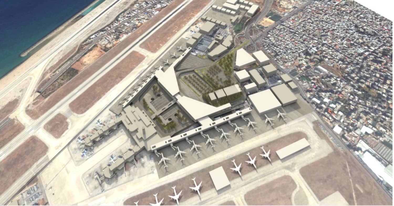
Lebanon - 2.2.1 Rafic Hariri International Airport
Airport Overview
Beirut–Rafic Hariri International Airport (Arabic: مطار رفيق الحريري الدولي بيروت, (previously known as Beirut International Airport) (IATA: BEY, ICAO: OLBA) is the only operational commercial airport in Lebanon, which is located in the Southern Suburbs of Beirut, Lebanon, 9 kilometers (5.6 mi) from the city centre. It is the hub for Lebanon's national carrier, Middle East Airlines (MEA), and was the hub for the Lebanese cargo carrier Cargo and Wings of Lebanon before their respective collapses.
The airport is named after former Lebanese Prime Minister Rafic Hariri in 2005, who was assassinated earlier that year.
It is the main port of entry into the country along with the Port of Beirut. The airport is managed and operated by the Directorate General of Civil Aviation (DGCA), which operates within the Ministry of Public Works and Transport. The DGCA is also responsible for operating the air traffic control (ATC) at the airport as well as controlling Lebanon's airspace. DGCA duties include maintenance and general upkeep ranging from cleaning the terminal to de-rubberizing the runways.
The airport features modern infrastructure and facilities, including two runways and several passenger terminals. The terminals are designed to handle both domestic and international flights, with separate areas for arrivals and departures. The airport has a range of services and amenities for passengers, including lounges, retail shops, restaurants, and duty-free outlets.
Operations and Key Bottlenecks/Procedural Issues:
While the airport aims to provide efficient operations, several bottlenecks and procedural issues have been reported, affecting both operators and customers. Some of the key challenges include:
- Security Concerns: Given Lebanon's geopolitical situation, security measures at the airport can be stringent, leading to longer processing times and thorough checks for passengers and luggage. This may cause delays and inconvenience for travellers.
- Air Traffic Congestion: Rafic Hariri International Airport experiences significant air traffic congestion, particularly during peak travel periods. Limited airspace capacity and the presence of military operations in the vicinity can contribute to congestion and delays.
- Infrastructure Limitations: Despite its modern facilities, the airport's infrastructure may face limitations, especially considering the increasing passenger traffic. Insufficient capacity, including limited check-in counters, security screening lanes, and immigration facilities, may result in congestion and longer waiting times.
- Customs and Immigration Procedures: Delays in customs and immigration procedures have been reported, with passengers experiencing lengthy queues and processing times. These delays can be a source of frustration for travellers.
- Operational Challenges: The airport has faced operational challenges, such as flight delays and cancellations, which can impact both operators and passengers. These issues can be attributed to a variety of factors, including air traffic congestion, weather conditions, and operational disruptions.
|
Airport Location and Contact |
|
|---|---|
|
Country |
Lebanon |
|
Province or District |
Beirut |
|
Nearest Town or City |
Beirut 9 KM |
|
Airport’s Complete Name |
Rafic Hariri International Airport |
|
Latitude |
33.820931 |
|
Longitude |
35.488389 |
|
Elevation (ft and m) |
87 feet (27 m) |
|
IATA Code |
BEY |
|
ICAO Code |
OLBA |
|
Managing Company or Airport Authority |
Directorate General of Civil Aviation (DGCA) |
|
Management Contact Person |
General Director: Eng. Fadi El-Hassan Tel: (961)1628195 - (961)1628196- (961)1628197 Fax: (961)1629010 |
|
Open From (hours) |
24/7 |
|
Open To (hours) |
24/7 |
Airport Picture
Description and Contacts of Key Companies
FBO/Handlers:
- Cedar Jet Center
- Executive Aircraft Services
Charter operators
- Cedar Executive
- Emerald Jets
- Med Airways
- Princess Aviation
- IBEX Air Charter
Maintenance providers
- Mideast Aircraft Service Co (MASCO)
- Executive Aircraft Services
For more information on airport contacts, please see the following link: 4.5 Airport Companies Contact List.
Information on some aviation service providers can be found at: http://www.azfreight.com/
Passenger and Cargo Performance Indicator
|
Performance for 2022 |
|||
|---|---|---|---|
|
Per Year |
Per Month |
Per Day |
|
|
Total Aircraft Movements |
6,544 |
545 |
18 |
|
Total Passengers |
6,349,799 |
529,149 |
17,396 |
|
Total Capacity of the Airport (MT) |
n/a |
n/a |
n/a |
|
Current Activity of the Airport (MT) |
106,361 |
8.863 |
291.4 |
|
Current use by Humanitarian Flights (UNHAS) |
n/a |
n/a |
n/a |
The airport acts as a crucial gateway linking the country to the rest of the world while being located in the centre of Beirut, Lebanon. Currently, a key element of Beirut's logistics scene is the airport's cargo capability. This capability does not, however, come without difficulties. Important limitations including aging infrastructure and constrained handling capacity have occasionally caused bottlenecks and delays. Measures are being taken to improve the performance of the airport's cargo to get around these obstacles.
A thorough modernization strategy that includes enlarged cargo terminals, improved equipment for handling, and simplified customs procedures is currently under development. Within the following two years, these improvements are anticipated to be finished. Once implemented, these developments are predicted to greatly increase the airport in Beirut's cargo capacity, accelerating the transportation of cargo.
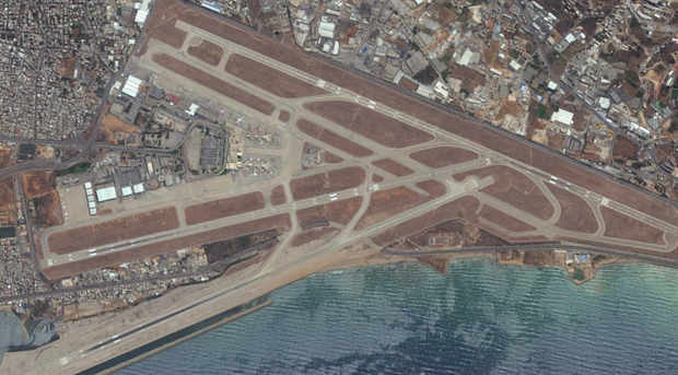
Runways
The lifeblood that connects Lebanon to the skies is the runway at Beirut Airport. The runway is now in fair shape thanks to ongoing maintenance operations that guarantee its operational integrity. The runway's durability, however, could be jeopardized by the airport's proximity to the shore and the difficult local climatic conditions, which include salt exposure and high temperatures. The runway's future usability and ability to serve as a vital hub for regional air traffic will depend on ongoing inspection and preventive maintenance.
|
Runway #1 |
|
|---|---|
|
Runway Dimensions |
3,800x45 m |
|
Orientation |
North South |
|
Surface |
Concrete |
|
Runway #2 |
|
|---|---|
|
Runway Dimensions |
3,395 x45 m |
|
Orientation |
North South |
|
Surface |
Concrete |
|
Runway #3 |
|
|---|---|
|
Runway Dimensions |
3,250x60 m |
|
Orientation |
North South |
|
Surface |
Concrete |
Helicopter Pad(s)
The helipad, which is conveniently located within the Beirut Airport complex, is a key hub for quick aerial connectivity. The helipad is currently in good working order thanks to regular maintenance. The helipad's small size and the rising demand for helicopter services, however, might make it difficult for it to be used in the future. As a result, it needs to be carefully managed so that it can handle rising traffic while maintaining safety standards.
|
Helipad #1 |
|
|---|---|
|
Present |
Yes |
|
Largest Helicopter that can Land |
No restriction |
|
Width and Length (m) |
No limitation |
|
Surface |
Concrete |
Airport Infrastructure Details
The airstrip at Beirut Airport is a crucial piece of infrastructure that supports the complex dance of aircraft movements. Runways, taxiways, aprons, and other crucial components are all included in the airfield. Currently, routine maintenance is performed on the airfield equipment to guarantee safe and effective operations. Carriers have, on occasion, expressed issues about parking availability during peak hours, which might cause brief delays. Apron areas will be expanded as part of measures to remedy this, improving the airport's ability to accommodate more aviation traffic. These planned upgrades are anticipated to reduce congestion problems and maximize the overall effectiveness of aircraft movements, enhancing the airport's standing as a significant regional hub.
|
Customs |
Yes |
JET A-1 fuel |
Yes |
|
Immigration |
Yes |
AVGAS 100 |
Yes |
|
Terminal Building |
Yes |
Single Point Refueling |
Yes |
|
Passenger Terminal |
Yes |
Air Starter Units |
Yes |
|
Cargo terminal |
Yes |
Ground Power (mobile) |
Yes |
|
Pax Transport to Airfield |
Yes |
Ground Handling Services |
Yes |
|
Control Tower |
Yes |
Latrine Servicing |
Yes |
|
Weather Facilities |
Yes |
Fire Fighting Category (ICAO) |
Yes |
|
Catering Services |
Yes |
De-icing Equipment |
Yes |
|
Base Operating Room |
Yes |
Parking Ramp Lighting |
Yes |
|
Airport Radar |
Yes |
Approach & Runway Lights |
Yes |
|
NDB |
Yes |
VOR |
Yes |
|
ILS |
Yes |
Yes |
Airport Operating Details
|
Operating Details |
|||
|---|---|---|---|
|
Maximum Sized Aircraft that can be Offloaded on Bulk Cargo |
No limitation |
||
|
Maximum Sized Aircraft that can be Offloaded on Pallet |
No limitation |
||
|
Total Aircraft Parking Area (m²) |
n/a |
||
|
Storage Area (m3 and MT) |
Import warehouse space 5000 m2 - Export warehouse space 650 m2: Six positions for pallets build-up-m3: n/a |
||
|
Handling Equipment |
|||
|
Elevators / Hi Loaders |
Yes |
Max Capacity (MT) |
n/a |
|
Max Height (m) |
n/a |
||
|
Loading Ramps |
Yes |
||
|
Other Comments |
One of MEAG's main business operations is ramp handling, where they provide a full variety of aircraft services for all types of aircraft, including freighters. Baggage loading and unloading, mail and freight delivery, ULD storage facilities, pushback and towing, marshalling, water and sanitary services, ground power units, air starter units, air conditioning units, station control (Red Caps), load control (weight & balance, load sheet), and aircraft cabin cleaning are all included in the ramp services. |
||
Customs Guidance
All UN agencies and foreign NGOs that are formally registered with the Lebanese government own a financial number provided by the Ministry of Finance, allowing them to be exempt from all customs, VAT, and entrance taxes at ports and borders, with the exception of the services costs that must be paid.
Storage Facilities
MEA (Middle East Airlines) offers a modern 2000 m², three-level warehouse accommodates customers’ imported cargo. E-Champ, and also MEA offers the following services:
- Palletizing
- Documentation
- Inventory Control
- Cargo Transport to /from aircraft
- Dangerous goods handling
- Live animal handling
- Tracing
- ULD build-up and breakdown
- Freight storage services of all kinds
- Courier and express services
- Handling of valuable freight
- Handling perishable good
- Airfield Costs
NAVIGATION CHARGES
|
Charges |
Aircraft Weight - MTOW (kg) |
||
|---|---|---|---|
|
0 - 7,000 |
7,001 - 136,000 |
136,001 and over |
|
|
Navigation (per journey) USD - $ |
50$ |
100$ |
100$ |
|
Landing USD - $ |
4$/1000 Kg |
||
|
Night Landing USD - $ |
|||
|
Night Take-Off USD - $ |
|||
|
Parking |
Less than an hour 5750-from 1 h to 2 h:8500-less than a day:140000 |
||
|
Handling Charges |
n/a |
||
FUEL SERVICES CHARGES
Fuel services are essential to Lebanon's Beirut Airport's support of the aviation sector. Aircraft operators often pay fees for jet fuel (Jet A-1) and avgas based on the amount of fuel they require. The fees are frequently based on volume (liters or gallons) and are determined by current market rates. These rates may change depending on variables including regional supply dynamics and world oil prices.
Operators are only charged for the actual fuel that they take from the airport's fueling stations. The charges are then added up using the unit cost per liter or gallon, which is determined by the state of the market and governmental regulations. These fees cover the cost of the airport's fuel production, storage, transportation, and handling services. In order to properly manage their operational costs and flight planning, operators must be aware of these fees and the factors that affect them.
|
Price per Litre USD - $ |
|
|---|---|
|
Jet A-1 |
3.12 |
|
Avgas |
4 |
CARGO TERMINAL CHARGES
AIR-BRIDGE CHARGES
Airbridge fees are a crucial part of the aviation operational environment at Beirut Airport in Lebanon. Airlines that use the airport's boarding bridges for passenger boarding and landing are responsible for paying these fees. With a normal cost of 150,000 Lebanese pounds (or 100 USD) for each period of three hours or a fraction thereof, the fees are typically assessed on a time-based basis.
Based on how long an aircraft occupies an air bridge, airlines are charged for its use. The fees are designed to pay for the boarding bridges' upkeep, operation, and servicing, which are essential for a smooth and effective passenger boarding process. This pricing structure incentivizes airlines to make the best use of boarding bridges, aligning with operational effectiveness, and boosting the airport's revenue stream. When operating at Beirut Airport, airlines must take these fees into account when determining their operational costs.
Security
To protect the security of passengers and aviation operations, Beirut Airport's security procedures are of utmost importance. The airport uses a complex security architecture that includes access control, surveillance systems, passenger and bag screening, and stringent security procedures in line with global aviation security standards. The geopolitical tensions in the area have, however, occasionally presented the airport with difficulties that have necessitated the need for increased attention.
Ongoing efforts are being made to strengthen the current security apparatus in order to allay these worries. The implementation of cutting-edge screening technologies, thorough security staff training programs, and tight cooperation with international partners to exchange intelligence are all part of these measures. The objective is to strengthen the airport's security posture and guarantee a safe environment for all parties. Even though Beirut Airport's exact international rankings or security measures may vary, the ongoing improvement efforts reflect the airport's dedication to upholding international aviation security standards and protecting its reputation as a safe travel hub.
Lebanon - 2.3 Road Network
Road Network

There are over 8,000 kilometers of roads in Lebanon, and there is a highway system that connects it to Syria.
There are three important highways in the nation, all of which branch out from Beirut. The road leading to Tripoli, the second-largest city in Lebanon, is located to the north. This route also travels through important cities like Jouniyeh and Jubayl. The road to Damascus is located to the east, passing past the important town of Chtaura as it crosses the Lebanon Mountains. The route to Saida and Tyre is to the south. A second road axis connecting north and south in Lebanon follows the length of the Bekaa Valley.The large market towns of Baalbek and Zahle are connected to the main road network via roads in the northern valley, which intersect on the Beirut-Damascus highway at Chtaura. The local road system in the southern valley is centered on Chtaura, which is located at its northern end.
In times of conflict or bad weather, cross-mountain routes that connect the southern Bekaa Valley with Saida and the northern Bekaa Valley with Jouniyeh and Tripoli are crucial.
Despite the fact that 95% of the roads are paved, traffic is growing quite quickly. With one car for every three people, Lebanon now boasts one of the highest car-to-person ratios in the world.
The Ministry of Public Works and Transport in Lebanon, the main government agency, is divided into four directorates:
1) The Directorate General of Land and Maritime Transport, which is in charge of establishing, carrying out, and overseeing all regulations pertaining to land and maritime transportation
2) Directorate General of Roads and Buildings, which is in charge of creating, renovating, and maintaining public roads and official structures
3) Directorate General of Civil Aviation, which is in charge of establishing and carrying out national air transportation regulations in accordance with international regulations and managing air traffic over Lebanese territory.
4) Directorate General of Urban Planning, which is in charge of developing and implementing land use policy.
In addition, the Ministry of Public Works' Rehabilitation and Reconstruction and the Council of Development and Reconstruction (CDR) are in charge of building and maintaining Lebanon's roads.
Transport Corridors
Transport Corridors Lebanon and Syria are connected by three operational corridors. These passageways are:
1) The border crossing at Al Masnaa-Al-Jdeidah, located in eastern Lebanon, is 60 kilometers from Damascus and 110 kilometers from Beirut. The principal route between the capitals of Syria and Lebanon is this one.
2) The Al-Arida-Tartous border crossing (in Lebanon's northwest). This corridor, which is near the coast, is frequently used to transfer merchandise between Syria and Lebanon. On the Syrian side, it is 45 km away from Tartous, while on the Lebanese side, it is 170 km away from Beirut.
3) The border crossing at Al-Abboudiyeh and Al-Dabouseyah (in Lebanon's northeast). From the Syrian side, this corridor connects the Homs Governorate to Tripoli from the Lebanese side. It is frequently used for freight transportation, particularly for items going to Iraq in transit.
Heavy snowfall during the winter months has temporarily made it difficult to use the international roadway leading to the Lebanon-Syrai Al Masnaa Crossing in the Dahr al Baidar region. However, the Ministry of Public Works typically resolves this in little more than one day. The Beirut-Damascus highway has occasionally been shut down for security concerns, but overall it continues to be the most reliable route for travel between Lebanon and Syria.
For more information on government contact details, please see the following link: 4.1 Government Contact List.
Distance Matrix
|
Distances from Capital City to Major Towns (km) |
||||||||
|---|---|---|---|---|---|---|---|---|
|
Beirut |
Tripoli |
Sidon |
Batroun |
Tyre |
Aley |
Chtaura |
Halba(Akkar) |
|
|
Beirut |
84 |
46 |
56 |
88 |
14 |
40 |
114 |
|
|
Tripoli |
130 |
33 |
175 |
92 |
86 |
30 |
||
|
Sidon |
100 |
45 |
43 |
66 |
55 |
|||
|
Batroun |
147 |
63 |
65 |
63 |
||||
|
Tyre |
54 |
106 |
204 |
|||||
|
Aley |
28 |
116 |
||||||
|
Chtaura |
104 |
|||||||
|
Halba(Akkar) |
||||||||
|
Travel Time from Capital City to Major Towns (KM) |
||||||||
|---|---|---|---|---|---|---|---|---|
|
Beirut |
Tripoli |
Sidon |
Batroun |
Tyre |
Aley |
Chtaura |
Halba(Akkar) |
|
|
Beirut |
1.5 h |
45 min |
1 h |
1.5 h |
15 min |
45 min |
2 h |
|
|
Tripoli |
2 h |
30 min |
2.5 h |
1.5 h |
1.5 h |
30 min |
||
|
Sidon |
2 h |
45 min |
1 h |
1 h |
1 h |
|||
|
Batroun |
2 h |
1 h |
1 h |
1 h |
||||
|
Tyre |
1 h |
2 h |
2.5 h |
|||||
|
Aley |
30 min |
2 h |
||||||
|
Chtaura |
1.5 h |
|||||||
|
Halba(Akkar) |
||||||||
Road Security
Efforts to ensure the safety of motorists on the country's roads are currently met with a variety of obstacles in Lebanon. A complex security environment has developed in the nation as a result of its particular geopolitical status, occasionally affecting road safety. Armed checkpoints are common in Lebanon, and their maintenance by various security forces is a reflection of the country's larger security concerns. Although the main goal of these checkpoints is to maintain law and order, they can occasionally cause traffic jams and make other road users feel uneasy.
In addition, the state of road infrastructure and upkeep has been hampered by economic hardship and political unrest. Drivers now face additional dangers due to deteriorating roads, limited signage, and poor illumination. Road safety hazards may become worse if traffic laws and enforcement are inconsistent. Urban traffic congestion, particularly in Beirut, is a major problem that can lengthen travel times, aggravate other road users, and pose safety issues.
In response to these difficulties, attempts have been made to solve the problem of road security. Concerned people, advocacy groups, and non-governmental organizations have advocated for increased road safety education, stricter enforcement of traffic laws, and improvements in road infrastructure. Even while there has been progress, there are still continuous economic and political uncertainties that make it difficult to put in place comprehensive road safety measures. To guarantee the safety and security of drivers across Lebanon, these challenges must be addressed.
Weighbridges and Axle Load Limits
In Lebanon, weighbridges are essential for managing and regulating vehicle loads to maintain traffic safety and safeguard road infrastructure. Vehicles operating on the nation's highways must comply with particular load constraints stipulated by current rules. To monitor and enforce these load restrictions, weighbridges are strategically positioned at numerous locations, including busy highways and border crossings.
These laws are necessary to prevent overloading, which puts the environment and road safety at risk by causing excessive wear and tear on bridges, roads, and other infrastructure. Vehicles that are discovered to be heavier than the permitted limits may be subject to fines and penalties. Relevant agencies in charge of upholding these laws and ensuring compliance keep an eye on weighbridge operations.
Weighbridges support fair competition among transport companies, ensure the effectiveness of logistics operations, and help to maintain the integrity of the road system. Lebanon wants to improve traffic safety, reduce infrastructure damage, and build a more sustainable transportation system by banning heavy vehicles off the highways.
|
Axle Load Limits |
Lebanon (Commercial)MT |
Lebanon (Donations/Humanitarian) MT |
|---|---|---|
|
Truck with 2 Axles |
25 |
30 |
|
Truck with 3 Axles |
35 |
40 |
|
Truck with 4 Axles |
n/a |
n/a |
|
Semi-trailer with 3 Axles |
n/a |
n/a |
|
Semi-trailer with 4 Axles |
35 |
40 |
|
Semi-trailer with 6 Axles |
n/a |
n/a |
|
Truck & Drawbar Trailer with 4 Axles |
n/a |
n/a |
|
Truck & Drawbar Trailer with 5 Axles |
n/a |
n/a |
|
Truck & Drawbar Trailer with 6 Axles |
n/a |
n/a |
|
Truck & Drawbar Trailer with 7 Axles |
n/a |
n/a |
Road Class and Surface Conditions
|
From |
To |
International Road No. |
Distance in km |
Road condition & environment |
||
|
No of. Lanes |
Age |
Environment |
||||
|
Dabousseyah cross border (Syria-Lebanon) |
Aboudeyah cross border (Lebanon-Syria) |
M51 |
18 |
2 |
>20 |
Coastal |
|
Aboudeyah cross border (Lebanon-Syria) |
Tripoli |
M51 |
5 |
2 |
>25 |
Coastal |
|
Tripoli |
Beirut |
M51 |
83 |
4 (Note: 2 and 3 lanes at some points) |
>20 |
Coastal |
|
Beirut |
Al-Naqoora |
M51 |
104 |
3 (and 2 lanes before Tyre until Naqoura) |
>20 |
Coastal |
|
Jedeidah cross border (Syria-Lebanon |
Al-Massnaá cross border (Lebanon-Syria) |
M30 |
6 |
2 lanes each side |
>20 |
Mountainous |
|
Al-Masnaa cross border (Lebanon-Syria) |
Beirut |
M30 |
53 |
4 |
>25 |
Mountainous |
|
Total Lebanon International Road Distance |
269 km |
|
|
|
|
|
Road Inventory
|
Classification |
Width/meter |
Length/ km |
|---|---|---|
|
International Roads |
10/14 |
269 |
|
Primary Roads (highways) |
10/14 |
261 |
|
Primary Roads |
10/8 |
1650 |
|
Secondary Roads |
5/8 |
1340 |
|
Local Roads |
4/6 |
2810 |
|
Total |
6,330 km |
|
Lebanon - 2.3.1. Land Border Crossing Al Masnaa
Border Crossing of Al Masnaa
Overview
The border crossing at Al Masnaa-Al-Jdeidah (Jdeidet Yabous), located in the eastern region of Lebanon, specifically in the Bekaa Valley. It is 55 kilometers from Damascus, 137 km from Tripoli, and 61 kilometers from Beirut. It serves as a crucial link between Lebanon and Syria as it is considered the principal route between the capitals of Syria and Lebanon.
It facilitates trade, commerce, and the movement of people between the two countries.
The border crossing is equipped with facilities for customs, immigration, and security checks. It caters to various types of traffic, including vehicles, pedestrians, and commercial transport.
Al Masnaa plays a vital role in enabling trade, tourism, and humanitarian aid to pass between Lebanon and Syria.
|
Border Crossing Location and Contact |
|
|---|---|
|
Name of Border Crossing |
Lebanon: Al Masnaa Syria:Jdeidet Yabous |
|
Province or District |
Est,Bekaa |
|
Nearest Town or City with Distance from Border Crossing |
Al Masnaa |
|
Latitude |
33.42.08 N |
|
Longitude |
35.55.18 E |
|
Managing Authority / Agency |
Custom and General Security |
|
Contact Person |
|
|
Travel Times |
|
|---|---|
|
Nearest International Airport |
Beirut Rafic Hariri International Airport 60 Km Truck Travel Time: 4 h Car Travel time: 1.30/2 h |
|
Nearest Port |
Beirut Port 61 km Truck Travel Time: 4 h Car Travel time: 2 h |
|
Nearest location with functioning wholesale markets, or with significant manufacturing or production capacity |
Zahle 21 km Truck Travel Time: 45 min/ 1 h Car Travel time: 30 min |
|
Other Information
|
There is a global highway along the path. |
|
Hours of Operation |
|
|---|---|
|
Mondays |
From 8 h to 17 h |
|
Tuesdays |
From 8 h to 17 h |
|
Wednesdays |
From 8 h to 17 h |
|
Thursdays |
From 8 h to 17 h |
|
Fridays |
No operation from Syria side-From 8 h to 17 h Lebanon Side |
|
Saturdays |
From 8 h to 17 h |
|
Sundays |
No operation from Syria side-From 8 h to 17 h Lebanon Side |
|
National Holidays
|
No operation. |
|
Seasonal Constraints |
Heavy snowfall during the winter months has temporarily made it difficult to access the international highway leading to the Lebanon-Syria Al Masnaa Crossing in the Dahr al Baidar region. The Ministry of Public Works and Civil Defense often resolve this within a day at most. The Beirut-Damascus highway has occasionally been shut down for security concerns, but overall it continues to be the most reliable route for travel between Lebanon and Syria. |
Daily Capacity
A separate lane is given for private vehicles,
Customs Clearance
All trucks are checked upon entry into the country by scanners, bomb detectors, and inspectors from the authorities.
Lebanon - 2.3.2 Land Border Crossing Al Arida
Border Crossing of Al Arida
Overview
Transport Corridors
The Al Arida border crossing is in the northern part of Lebanon, near the town of Arida in the Akkar Governorate. It is situated on the border with Syria.
Al Arida is one of the major land border crossings between Lebanon and Syria. It plays a crucial role in facilitating trade, commerce, and the movement of people between the two countries.
This corridor, which is near the coast, is frequently used to transfer merchandise between Syria and Lebanon. On the Syrian side, it is 32 km away from Tartous, while on the Lebanese side, it is 31 km from Tripoli, and 113 km away from Beirut.
|
Border Crossing Location and Contact |
|
|---|---|
|
Name of Border Crossing |
Lebanon: Al Arida Syria:Al Arida |
|
Province or District |
North |
|
Nearest Town or City with Distance from Border Crossing |
Al Arida |
|
Latitude |
34.37.59 N |
|
Longitude |
35.58.34 E |
|
Managing Authority / Agency |
Custom and General Security |
|
Contact Person |
|
|
Travel Times |
|
|---|---|
|
Nearest International Airport |
Beirut Rafic Hariri International Airport 113 Km Truck Travel Time: 4 h Car Travel time: 3 h |
|
Nearest Port |
Beirut Port 65 km Truck Travel Time: 4 h Car Travel time: 2 h |
|
Nearest location with functioning wholesale markets, or with significant manufacturing or production capacity |
Tripoli 30 km Truck Travel Time: 45 min/ 1 h Car Travel time: 30 min |
|
Other Information
|
There is a global highway along the path. |
|
Hours of Operation |
|
|---|---|
|
Mondays |
From 8 h to 17 h |
|
Tuesdays |
From 8 h to 17 h |
|
Wednesdays |
From 8 h to 17 h |
|
Thursdays |
From 8 h to 17 h |
|
Fridays |
No operation from Syria side-From 8 h to 17 h Lebanon Side |
|
Saturdays |
From 8 h to 17 h |
|
Sundays |
No operation from Syria side-From 8 h to 17 h Lebanon Side |
|
National Holidays
|
No operation. |
|
Seasonal Constraints |
N/A |
Daily Capacity
A separate lane is given for private vehicles,
Customs Clearance
All trucks are checked upon entry into the country by scanners, bomb detectors, and inspectors from the authorities.
Lebanon - 2.3.3 Land Border Crossing Aboudiyeh
Border Crossing of Aboudiyeh
Overview
Transport Corridors
The Al-Abboudieh border crossing is in the northern part of Lebanon, specifically in the Akkar Governorate. It sits on the border with Syria.
The Al-Abboudieh border crossing serves as a gateway for various activities, including trade, tourism, and humanitarian aid. It is frequently used for freight transportation, particularly for items going to Iraq in transit.
From the Syrian side, this corridor connects the Homs Governorate to Tripoli from the Lebanese side.
It is 61 km away from Homs in Syria, while on the Lebanese side, it is 37 km away from Tripoli and 120 km away from Beirut.
|
Border Crossing Location and Contact |
|
|---|---|
|
Name of Border Crossing |
Lebanon: Aboudieh Syria: Addabousiah |
|
Province or District |
North,Akkar |
|
Nearest Town or City with Distance from Border Crossing |
Aboudieh |
|
Latitude |
34.38.19 N |
|
Longitude |
36.07.09 E |
|
Managing Authority / Agency |
Customs and General Security |
|
Contact Person |
|
|
Travel Times |
|
|---|---|
|
Nearest International Airport |
Beirut Rafic Hariri International Airport 127 Km Truck Travel Time: 6 h Car Travel time: 3 / 4 h |
|
Nearest Port |
Tripoli Port 37 km Truck Travel Time: 3 h Car Travel time: 1.5 h |
|
Nearest location with functioning wholesale markets, or with significant manufacturing or production capacity |
Tripoli area 38 km Truck Travel Time: 3 h Car Travel time: 1 / 1.30 min |
|
Other Information
|
There is a global highway along the path. |
|
Hours of Operation |
|
|---|---|
|
Mondays |
From 8 h to 17 h |
|
Tuesdays |
From 8 h to 17 h |
|
Wednesdays |
From 8 h to 17 h |
|
Thursdays |
From 8 h to 17 h |
|
Fridays |
No operation from Syria side-From 8 h to 17 h Lebanon Side |
|
Saturdays |
From 8 h to 17 h |
|
Sundays |
No operation from Syria side-From 8 h to 17 h Lebanon Side |
|
National Holidays
|
No operation. |
|
Seasonal Constraints |
N/A |
Daily Capacity
A separate lane is given for private vehicles,
Customs Clearance
All trucks are checked upon entry into the country by scanners, bomb detectors, and inspectors from the authorities.
Lebanon - 2.3.4 Land Border Crossing of Ras Al Naqoura (Rosh HaNikra)
Border Crossing of Ras Al Naqoura (Rosh HaNikra)
Overview
At the border between Naqoura, Lebanon, and Rosh HaNikra, Israel, lies the Rosh Hanikra Crossing. This terminal is exclusively managed by the United Nations Interim Force in Lebanon (UNIFIL) and the Israel Defense Forces (IDF).
Access for ordinary tourists and visitors is strictly prohibited. Civilians cannot enter an area within 4 km (2.5 miles) of the shared border with Lebanon.
As it is not possible to enter Lebanon from the country's southern border with Israel, your only option to enter Lebanon by land is from its northeastern neighbour, Syria.
|
Border Crossing Location and Contact |
|
|---|---|
|
Name of Border Crossing |
Lebanon: Ras Al Naqoura Israel: Rosh HaNikra |
|
Province or District |
Al Naqoura - South |
|
Nearest Town or City with Distance from Border Crossing |
Naqoura |
|
Latitude |
|
|
Longitude |
35°06′17″E |
|
Managing Authority / Agency |
IDF, UNIFIL |
|
Contact Person |
|
|
Travel Times |
|
|---|---|
|
Nearest International Airport |
Beirut Rafik Hariri Int. Airport (108 KM) |
|
Nearest Port |
Beirut Port 142 km Truck Travel Time: 3-4 h Car Travel time: 2 h |
|
Nearest location with functioning wholesale markets, or with significant manufacturing or production capacity |
Tyre (known as Sour) 45 km Truck Travel Time: 60 min Car Travel time: 40 min |
|
Other Information
|
N/A |
|
Hours of Operation |
|
|---|---|
|
Mondays |
N/A |
|
Tuesdays |
N/A |
|
Wednesdays |
N/A |
|
Thursdays |
N/A |
|
Fridays |
N/A |
|
Saturdays |
N/A |
|
Sundays |
N/A |
|
National Holidays
|
N/A |
|
Seasonal Constraints |
No info as the border is not functioning for passenger crossing or cargo movement.*
*Due to escalations in Israel/Lebanon from the 7th of October 2023 attacks and the ongoing conflict in the Gaza Strip, the border will remain closed for the foreseeable future. |
Daily Capacity
No info as the border is not functioning for tourism or cargo movement.
Customs Clearance
No customs at the border as no cargo/freight can pass through this border.