Nepal - 2.3.8 Minor Border Crossing - Mahakali-Jhulaghat
Overview
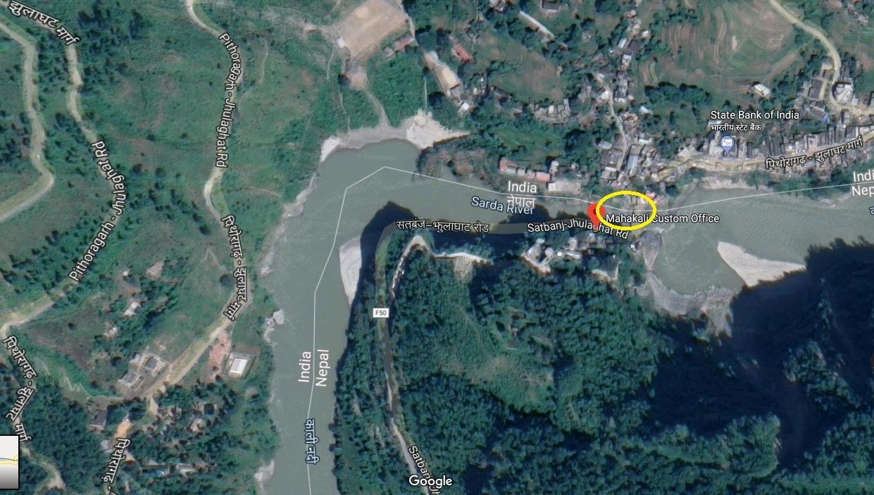
The Mahakali Customs office is the main customs office under the Department of Customs of Nepal for Sudurpashchim province. The office manages the custom related activities of 6 other sub-customs offices in the region. The Mahakali River separates the border between Nepal and India. Both Nepal and India have parallel road on each side of the border, but the roads are not connected and hence this border crossing is inaccessible for vehicles. A small suspension bridge for pedestrians only links the two countries.
Mahakali-Jhulaghat is a minor border crossing, not rated among the main 23 border crossing points in terms of import share. Therefore, this crossing point is not recommended for cargo import & export.
|
|
|
Picture: Border Crossing in Jhulaghat, Baitadi in between Nepal-India |
|
Border Crossing Location and Contact |
|
|---|---|
|
Name of Border Crossing
|
Nepal: Mahakali |
|
Province or District |
Sudurpaschim Province in Nepal Uttarakhand, India |
|
Nearest Town or City with Distance from Border Crossing |
Dashrathchand Municipality-Khalanga-Baitadi in Nepal Distance 17 km Pithauragad in India Distance 36 km |
|
Latitude |
29.80144 |
|
Longitude |
80.46421 |
|
Managing Authority / Agency |
Government of Nepal-Ministry of finance Department of Custom-Mahakali-Jhulaghat Custom Office |
|
Contact Person |
Mr. Anil Jha Email: mahakali@customs.gov.np
|
The customs office has two small rooms used as warehouses measuring 12 ft x 15 ft each and an open space area of 7587 m2 available.
|
Travel Times |
|
|---|---|
|
Nearest International Airport |
Name: Gautam Buddha International Airport, Bhairawaha Distance in km: 618 KM Truck Travel Time: 16 – 18 hrs Car Travel time: 15 hrs |
|
Nearest Port |
Name: Dashrathchand Municipality-Khalanga Baitadi Distance is 17 km Truck Travel Time: 45 Minutes Car Travel time: 30 Minutes |
|
Nearest location with functioning wholesale markets, or with significant manufacturing or production capacity |
Name: Dashrathchand Municipality-Khalanga Baitadi Distance is 17 km Truck Travel Time: 45 Minutes Car Travel time: 30 Minutes |
|
Other Information
|
Kolkota is the nearest seaport in India side to import and export third country goods 1,478 KM away from Jhulaghat -Mahakali takes 30-32 Hours travel time.
The only one Integrated check post with the port facility is available only in Birgunj- Bara in Nepal, which is 835 KM away from Jhulaghat takes around 20 hour travel time. |
|
Hours of Operation |
|
|---|---|
|
Mondays |
07:00 AM to 07:00 PM |
|
Tuesdays |
07:00 AM to 07:00 PM |
|
Wednesdays |
07:00 AM to 07:00 PM |
|
Thursdays |
07:00 AM to 07:00 PM |
|
Fridays |
07:00 AM to 07:00 PM |
|
Saturdays |
07:00 AM to 07:00 PM |
|
Sundays |
07:00 AM to 07:00 PM |
|
National Holidays
|
Generally, 3 days during Dashain (Nepal national festival) and up to another 7 days / year at Government’s discretion.
|
|
Seasonal Constraints |
Flood in Mahakali River during July and August |
Daily Capacity
The bridge over the Mahakali River is a small suspension bridge and serves only as a pedestrian bridge. The nearest Indian city close to this border is Pithauragad, which is 36 KM away from Jhulaghat and takes one and half-hour by vehicle.
Customs Clearance
Compulsory Document for custom clearance.
-
D & T Exemption Certificate
-
Invoice
-
AWB/BL/Other Transport Documents
-
Donation/Non-Commercial Certificates
-
Packing list
-
Letter of credit
-
Certificate of origin
-
Certificate of insurance
-
Bill of Lading / Airway Bill
-
Industry Registration Certificates
-
Permanent Account Number (with VAT Registration and Income Tax Registration if not exempt)
For more information on customs in Jhulaghat-Baitadi, Nepal, please see the following link: 1.3 Customs Information.
Other Relevant Information
In Nepal side, There is a Feeder road F-50 at Jhulaghat, which is connected with Mahakali Highway at Satbanjh, at 37 kilometres (23 mi) of distance. jhulaghat is the end point of Mid-Hills Highway of Nepal which starts at Chiyo Bhanjyang. Chiyo Bhanjyang is a border point between Koshi Province (Nepal) and Sikkim (India). The Mid-Hill highway runs. 1,776 KM through Mid hills of Nepal. The delays at Border Posts can be extensive – from 2 days to a weeklong. This is not an appropriate crossing border point to import and export goods.
For more information on government contact details, please see the following link: 4.1 Government Contact List.