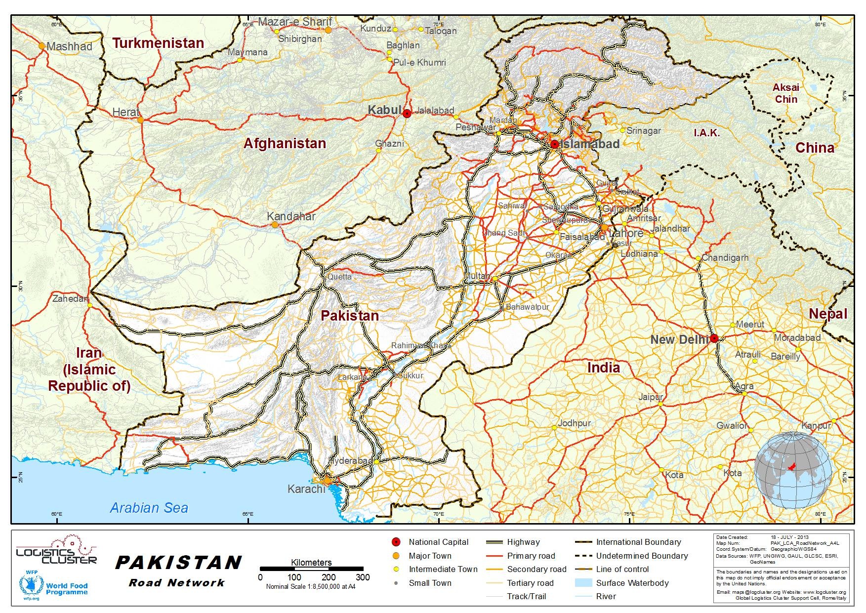
2.3 Pakistan Road Network
Pakistan Road Network
For information on road contact details, please see the following link:
4.1 Pakistan Government Contact List
(Sources: Pakistan Transport Plan Study, 2006; Pak Econ Survey,
2010; National Transport Research Center– Deputy Chief of
NTRC)
Road is the dominant mode of inland traffic in Pakistan and carries 91% of passenger traffic and 96% of freight traffic (Source: NHA) . Current road density in Pakistan is 0.32km/km-sq. Pakistan’s road network is vital for the movement of people and goods and plays an important role in integrating the country, facilitating economic growth and reducing poverty. Pakistan has a road network covering 259,618 kilometres including 179,290 KM of high type roads and 80,328 KM of low type roads. Total roads, which were 229,595 KM in 1996‐97, increased to 259,618 KM by 2009‐10 (Jul‐Mar) an increase of 13 percent. A sizable and continuous improvement of the high type road network was observed from 1996‐97 to 2009‐10 (Jul‐Mar). (Pak Econ Survey,2010)
The distance between Islamabad, the capital of Pakistan in the north-east of the country, and Karachi, the provincial capital of Sindh having two important international ports, is about 1, 200 km (PTPS, 2006). This forms the main transport corridor of Pakistan, with the bulk of freight transport passing through it.About 60% of the road network in Pakistan consists of paved roads.
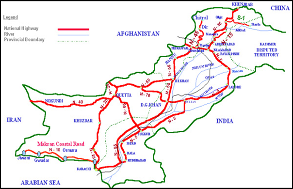
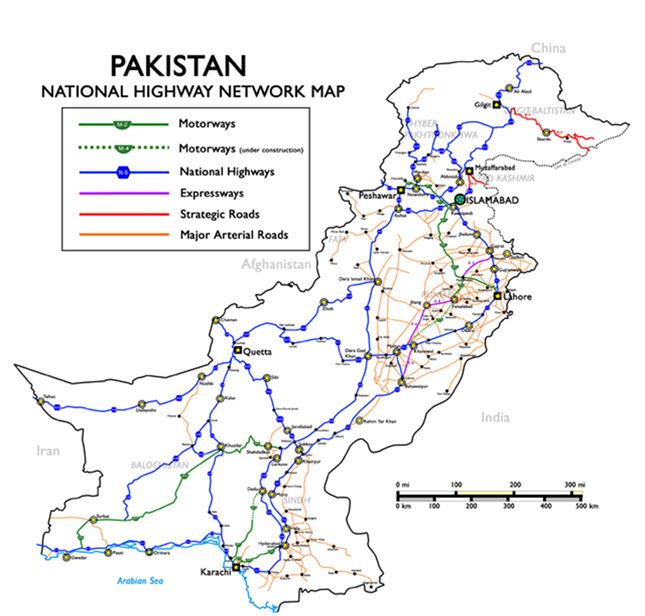
National Highways:
The National Highways of Pakistan consists of all public highways maintained by National Highways Authority under the Ministry of Transport. It maintains over 12,000 kilometres (7,500 mi) of roadways organised into various classifications which crisscross the country and provide access to major population centres. These are not to be confused with provincial highways, which are provincial roads maintained by the respective provinces. Pakistan's national highways include the famous Grand Trunk Road, Indus Highway, Karakoram Highway and Makran Coastal Highway.
All national highways in Pakistan are pre-fixed with the letter 'N' (for "National") followed by the unique numerical designation of the specific highway (with a hyphen in the middle), e.g. "N-5". Each numerical designation is separated by five numerals, i.e. N-5, N-10, N-15, etc.
National Highways are distinct from 'Strategic Highways', which begin with the prefix 'S' and are owned, controlled and operated by the Ministry of Defense.
|
National Highways |
||||||
|---|---|---|---|---|---|---|
|
Sign |
Course |
Length |
Existing |
Status |
Lanes |
Completion |
 |
1819 km |
1819 km |
via Hyderabad, Multan, Lahore, Gujranwala, Gujrat, Islamabad, Rawalpindi, Peshawar |
6 |
1952 |
|
 |
653 km |
653 km |
2 |
2003 |
||
 |
240 km |
240 km |
via Naran |
2 |
||
 |
Karachi – Chaman (RCD Highway) |
813 km |
813 km |
2 |
||
 |
110 km |
110 km |
2 |
|||
 |
806 km |
806 km |
via Abbottabad, Thakot, Gilgit becoming China National Highway 314 |
4 |
||
 |
610 km |
610 km |
2 |
|||
 |
309 km |
309 km |
via Dir |
2 |
||
 |
531 km |
531 km |
via Zhob |
2 |
||
 |
1264 km |
1264 km |
via Kotri, Shikarpur, Dera Ghazi Khan, Kohat |
4 (6) |
||
 |
385 km |
385 km |
via Sibi |
2 |
||
 |
447 km |
447 km |
via Loralai, Dera Ghazi Khan |
2 |
||
 |
90 km |
90 km |
via Murree |
4 |
||
 |
Islamabad – Kohat |
146 km |
146 km |
2 |
||
 |
487 km |
487 km |
2 |
|||
 |
64 km |
64 km |
via Alpuri |
2 |
||
 |
135 km |
135 km |
2 |
|||
|
61 km |
61 km |
2 |
||||
|
90 km |
90 km |
2 |
||||
|
220 km |
220 km |
via Mirpur Khas, Umerkot |
2 |
|||
|
44 km |
44 km |
via Khanpur |
2 |
|||
|
28 km |
28 km |
2 |
||||
|
34 km |
34 km |
2 |
||||
|
35 km |
35 km |
2 |
||||
|
50 km |
50 km |
2 |
||||
|
18 km |
18 km |
2 |
||||
|
|
Total |
12131 km |
12131 km |
|
|
|
Distance Matrix
|
Distance From City |
Distance To City |
Distance (km) |
|---|---|---|
|
Karachi (Sindh) Between |
Lahore (Punjab)Distance |
1030.38 |
|
Faisalabad (Punjab)Between |
Rawalpindi (Punjab)Distance |
242.77 |
|
Multan (Punjab)Between |
Hyderabad (Sindh)Distance |
617.81 |
|
Gujranwala (Punjab)Between |
Peshawar (North-West Frontier)Distance |
319.04 |
|
Quetta (Balochistan)Between |
Islamabad (Islamabad)Distance |
685.82 |
|
Bahawalpur (Punjab)Between |
Sargodha (Punjab)Distance |
312.96 |
|
Sialkot (Punjab)Between |
Sukkur (Sindh)Distance |
761.47 |
|
Larkana (Sindh)Between |
Shekhupura (Punjab)Distance |
723.89 |
|
Jhang Sadr (Punjab)Between |
Gujrat (Punjab)Distance |
220.45 |
|
Mardan (North-West Frontier)Between |
Kasur (Punjab)Distance |
409.85 |
|
Dera Ghazi Khan (Punjab) |
Sahiwal (Punjab)Distance |
246.09 |
|
Nawabshah (Sindh)Between |
Mingaora (North-West Frontier) |
1020.27 |
|
Okara (Punjab)Between |
Mirpur Khas (Sindh)Distance |
730.48 |
|
Chiniot (Punjab)Between |
Kamoke (Punjab)Distance |
121 |
|
Sadiqabad (Punjab)Between |
Burewala (Punjab)Distance |
320.46 |
|
Jacobabad (Sindh)Between |
Muzaffargarh (Punjab)Distance |
333.58 |
|
Muridke (Punjab)Between |
Jhelum (Punjab)Distance |
135.17 |
|
Shikarpur (Sindh)Between |
Hafizabad (Punjab)Distance |
667.61 |
|
Kohat (North-West Frontier) |
Khanpur (Punjab)Distance |
554.09 |
|
Khuzdar (Balochistan)Between |
Dadu (Sindh)Distance |
165.41 |
|
Gojra (Punjab)Between |
MandiBahauddin (Punjab)Distance |
177.05 |
|
TandoAllahyar (Sindh)Between |
Daska (Punjab)Distance |
939.62 |
|
Pakpattan (Punjab)Between |
Bahawalnagar (Punjab)Distance |
42.74 |
|
Tando Adam (Sindh)Between |
Khairpur (Sindh)Distance |
196.69 |
|
ChishtianMandi (Punjab)Between |
Jaranwala (Punjab)Distance |
178.91 |
|
Distance From City |
Distance To City |
Distance (km) |
|---|---|---|
|
Ahmadpur East (Punjab)Between |
Vihari (Punjab)Distance |
143.59 |
|
Kamalia (Punjab)Between |
KotAddu (Punjab)Distance |
163.95 |
|
Khushab (Punjab)Between |
Wazirabad (Punjab)Distance |
166.54 |
|
Dera Ismail Khan (North-West Frontier)Between |
Chakwal (Punjab)Distance |
221.33 |
|
Swabi (North-West Frontier) |
Lodhran (Punjab)Distance |
516.1 |
|
Nowshera Cantonment (North-West Frontier)Between |
Charsadda (North-West Frontier)Distance |
30.76 |
|
Jalalpur (Punjab)Between |
Mianwali (Punjab)Distance |
248.26 |
|
Chaman (Balochistan)Between |
Kandhkot (Sindh)Distance |
397.97 |
|
Hasilpur (Punjab)Between |
Arifwala (Punjab)Distance |
80.36 |
|
Attock City (Punjab)Between |
Chichawatni (Punjab)Distance |
361.48 |
|
Bhakkar (Punjab)Between |
Kharian (Punjab)Distance |
294.39 |
|
Leiah (Punjab)Between |
Kambar (Sindh)Distance |
470.11 |
|
Moro (Sindh)Between |
MianChannun (Punjab)Distance |
598.9 |
|
Turbat (Balochistan)Between |
Shahdadkot (Sindh)Distance |
522.73 |
|
Bhalwal (Punjab)Between |
Dipalpur (Punjab)Distance |
191.48 |
|
Badin (Sindh)Between |
PanoAqil (Sindh)Distance |
356.93 |
|
Kotri (Sindh)Between |
Tando Muhammad Khan Distance(Sindh) |
34.98 |
|
Harunabad (Punjab)Between |
Pattoki (Punjab)Distance |
170.31 |
|
KahrorPakka (Punjab)Between |
Gujar Khan (Punjab)Distance |
427 |
|
Kot Malik (Balochistan)Between |
Chuhar Kana (Punjab)Distance |
671.01 |
|
Toba Tek Singh (Punjab)Between |
Narowal (Punjab)Distance |
260.01 |
|
Shorko (North-West Frontier) |
Shahdadpur (Sindh)Distance |
700 |
|
Shabqadar (North-West Frontier) |
Mansehra (North-West Frontier)Distance |
151.69 |
|
Shujaabad (Punjab)Between |
Haveli (Punjab)Distance |
239.16 |
|
Lala Musa (Punjab)Between |
Mailsi (Punjab)Distance |
364.58 |
|
Distances from Capital City to Major Towns (km) |
||||||||
|---|---|---|---|---|---|---|---|---|
|
Islamabad |
Karachi |
Lahore |
Peshawar |
Quetta |
Multan |
Mingora |
Gwadar |
|
|
Islamabad |
1350 |
300 |
180 |
800 |
480 |
170 |
1600 |
|
|
Karachi |
1350 |
1030 |
1300 |
700 |
850 |
1450 |
550 |
|
|
Lahore |
300 |
1030 |
450 |
860 |
370 |
480 |
1600 |
|
|
Peshawar |
180 |
1300 |
450 |
700 |
700 |
140 |
1550 |
|
|
Quetta |
800 |
700 |
860 |
700 |
500 |
850 |
850 |
|
|
Multan |
480 |
850 |
370 |
700 |
500 |
620 |
1250 |
|
|
Mingora |
170 |
1450 |
480 |
140 |
850 |
620 |
1700 |
|
|
Gwadar |
1600 |
550 |
1600 |
1550 |
850 |
1250 |
1700 |
|
Weighbridges and Axle Load Limits
Weighbridges
NHA has 54 weigh stations to enforce axle load limits. Currently the fine for overloading is about Rs. 100 per ton, but there are many problems with enforcing these fines due to the weigh stations being located in remote areas in many cases.
Operators and drivers often negotiate these fines in case of large amounts of overloading. Another issue is that there is often limited space for unloading at the weigh station, as well as limited parking space for overloaded trucks.
Follow below link for a listing of weighbridges in the country:
http://www.phonebook.com.pk/dynamic/search.aspx?SearchType=kl&k=Weighbridge&l=Pakistan
Axle Load Limits
The National Highways Safety Ordinance 2000 stipulates maximum axle loads and tyre pressures:
- Front axle – 5 tonnes
- Single axle – 12 tonnes
- Tandem axle – 22 tonnes
- Tridem axle – 33 tonnes
- Tyre pressure rear axle 120 psi
- Tyre pressure – front axle 100 psi
Some concessions were allowed on National Highways through agreement with the NHA, but none on the motorway.
|
Truck Type |
Allowed on National Highways |
Allowed on Motorways |
|---|---|---|
|
2 AX SINGLE (BEDFORD) |
20 |
17.5 |
|
2 AX SINGLE (HINO/ NISSAN) |
23 |
17.5 |
|
3 AX TANDEM |
32 |
27.5 |
|
3 AX SINGLE |
32 |
29.5 |
|
4 AX SINGLE TANDEM |
42 |
39.5 |
|
4 AX TANDEM SINGLE |
42 |
39.5 |
|
4 AX SINGLE |
44 |
41.5 |
|
5 AX SINGLE TRIDEM |
51 |
48.5 |
|
5 AX TANDEM TANDEM |
52 |
49.5 |
|
5 AX SINGLE SINGLE TANDEM |
54 |
51.5 |
|
5 AX TANDEM SINGLE SINGLE |
54 |
51.5 |
|
6 AX TANDEM TRIDEM |
61 |
58.5 |
|
6 AX TANDEM SINGLE TANDEM |
64 |
61.5 |
Road Class and Surface Conditions
ROAD LENGTH AND DENSITY TABLE (Source: NTRC, 2006)
|
Pakistan |
Punjab |
Sindh |
KPK |
Balochistan |
|
|---|---|---|---|---|---|
|
Total Road Length (km) |
258, 214 |
106. 140 |
79, 834 |
30, 049 |
42, 191 |
|
%age of paved road |
63% |
78% |
69% |
46% |
13% |
|
Area (km2 ) |
796,095 |
206,250 |
140,914 |
101,741 |
347,190 |
|
Road Density (km/km2) |
0.32 |
0.51 |
0.57 |
0.30 |
0.12 |
|
Population (million) |
148.72 |
85.33 |
32.99 |
23.26 |
7.14 |
|
Road Length per Mil. People (km) |
1,736 |
1,244 |
2,420 |
1,292 |
5,909 |
|
Number of Registered Vehicles |
4,974,000 |
2,920,984 |
1,457,323 |
430,429 |
165,264 |
|
Road Length per 1,000 Vehicles |
52 |
36 |
55 |
70 |
255 |
ADMINISTRATIVE CLASSIFICATION OF ROADS – (Source: NTRC, 2006)
|
Classification |
Administration |
Length |
Function |
|---|---|---|---|
|
National Highway, Motorways, Strategic Roads. |
National Highway Authority (NHA), Ministry of Communications |
9, 000 km |
Representing the main transport corridors and providing inter-provincial linkages and connections to the neighboring countries |
|
Provincial Roads |
Communications and Works Department (C&WD); Works and Services Department ( WSD), and; Frontier Highway Authority (FHA) |
101, 000km |
Providing access to the economic and population centres in the four provinces |
|
District Roads |
District Government |
94,000km |
Providing access to villages and remote areas |
|
Municipal and Cantonment Roads |
Municipal Government and army |
54,000km |
Providing access to villages and remote areas. |
There are 14 National Highways (8,600 km), 5 Motorways (767 km), and two Strategic Roads (270km) in Pakistan as listed in the tableabove.
N5 is the longest and most important National Highway. N-55 is the second longest National Highway. N-25 is an important international and national highway connecting Karachi with Quetta and Chaman on the Afghanistan border.
There are many topographical obstacles on the National Highways. For example, the Kohat tunnel has only 2 lanes despite the importance of N-55. N-70 has a very dangerous mountainous section between D.G.Khan and Fort Munro, where on a winding section, rocks stick out over the road, and slopes are very steep.
The Khushalgarh Bridge over the River Indus on N-80 is old and narrow. This bridge crosses its access roads at right angles, disallowing container trucks to pass over it. The Lowari Rail Tunnel Project is underway to overcome such topographical obstacles on N-45. The Malakand Tunnel (N-45) and the Lakpass Tunnel ( N-25) are also planned to improve road transport. Many new bridges over the River Indus and other big rivers are proposed.
The major function of National Highways is to carry inter-provincial traffic or long distance traffic along national corridors, connecting the major cities. Accordingly, National Highways have many congested cities as bottlenecks along their routes. Many bypasses have been constructed in major cities for National Highways to avoid congestion. However, soon after opening a bypass for a city, the city begins to grow along the bypass, and the growth continues until the bypass soon ceases to function properly. This is where more controlled access to national highways could alleviate the situation.
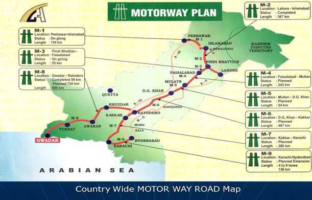
NHA plans to develop a network of full access controlled Motorways as a new economic corridor to provide fast transportation of goods and passengers. The total length of the planned Motorway network is 2,734 km.
Issues: Overloading by trucks is a typical phenomenon in the transport sector in Pakistan. It is common for 2-axle trucks, having a high vertical limit on the rear, carry heavy loads to the extent of the dimensional limit instead of the tonnage limit. Overloading causes severe road maintenance issues due to the weight over the capacity of the pavement, as well as unwanted road accidents.
International corridors
For information on Pakistan international corridors, please see the following document:
2.3.1 Gwadar Road Assessment
Since the inauguration of Makran Coastal Highway (N10), Gwadar City has been connected to the entire country/region via Karachi (Eastern Route) and Quetta (Western Route). The Highway is around 655 km paved single carriage road, and passes by the Arabian Sea coastline of Pakistan. It connects with major upcountry routes at two locations and continues upward.
At Liari/Zero Point it terminate into RCD (Quetta - Karachi) highway. No Major cities on route except Ormara, a small coastal town. At Kapper it turns towards Turbat and Hoshab and converts into Motorway (M8), Hoshab onwards it continues towards Quetta and Bella via N85. Form Turbat it also takes a turn towards Iran.
Currently, Gwadar from Karachi through N10 is commutable within a smooth none-stop drive of eight hours (LTV), however, with any increase in traffic the drive time shall increase as road is only 2 lane (30 Foot) wide and will not be able to accommodate projected traffic from Gwadar Port and vice versa.
There are no regular fuel stations, Workshops and Rest area on route, nonetheless, smuggled fuel of low quality is available at certain points.
The National Highway Authority (NHA) was created, in 1991, through an Act of the Parliament, for planning, development, operation, repair and maintenance of National Highways and Strategic Roads specially entrusted to NHA by the Federal Government or by a Provincial Government or other authority concerned.
NHA sublets and governs the construction and one of major national organization is FWO (frontier works organization). Frontier Works Organization (FWO), today’s most versatile and vibrant construction frm, was established on 31 October 1966 to wrought a miracle and carve out a modern highway, the Karakoram Highway, across crags and crevices of the highest mountain ranges of the world.
|
Sign |
Course |
Length |
Lanes |
Completion Year |
Status |
Remarks |
 |
Karachi – Gwadar |
655 km |
2 |
2003 |
Operational |
|
 |
Karachi – Chaman via Quetta |
813 km |
2 |
- |
Operational |
Continues as Kandahar–Spinboldak Road in Afghanistan. Also known as RCD Highway |
 |
Hushab - Surab via Turbat and Panjgor |
487 km |
2 |
- |
Operational |
( Based on Information received from Local residents The Same road Continues to Quetta and Chaman |
|
|
Gwadar – Ratodero via Bela |
892 |
2 |
|
Partially Operational |
Based on Information received from Local residents |
|
|
Gwadar - Jewini |
|
2 |
|
Operational |
Makran Coastal Highway |
For more information on government contact details, please see the following link: 4.1 Pakistan Government Contact List
Distance Matrix
|
DISTANCES FROM CAPITAL CITY TO MAJOR TOWNS (km) |
|||||||
|---|---|---|---|---|---|---|---|
|
Origin/ Destination |
Karachi |
Quetta |
Peshawar |
Torkham Border |
Chaman Border |
Lahore |
Islamabad |
|
Gwadar |
(620.5 km) via Makran Coastal Highway |
(1096 km) Via Makran Coastal HW and RCD HW |
1,927.1 km) via Makran Coastal Highway, RCD Hwy and N-50 |
(1,968.7 km) via Makran Coastal Highway, RCD Hwy and N-50 |
(1,214.3 km) via Makran Coastal Highway and Regional Cooperation for Development |
1,849 km
|
2,010 km
|
Travel Time Matrix
|
|
Karachi |
Quetta |
Peshawar |
Torkham |
Chamman |
Lahore |
Islamabad |
|---|---|---|---|---|---|---|---|
|
Gwadar |
8 h 45 min
|
14 h 8 min
|
27 h
|
28 h
|
16 h 13 min
|
27 h
|
28 h
|
Road Security
Security along the route is ok but it is required to be cautious and keep connected with security officials to follow guidelines.
Security: Marginal
Weighbridges and Axle Load Limits
No weighbridges
|
Axle load limits |
LCA Country |
Transit Country |
Transit Country |
|---|---|---|---|
|
Truck with 2 axles |
17.5 |
17.5 |
17.5 |
|
Truck with 3 axles |
29.5 |
29.5 |
29.5 |
|
Truck with 4 axles |
39.5 |
39.5 |
39.5 |
|
Semi-trailer with 3 axles |
27.5 |
27.5 |
27.5 |
|
Semi-trailer with 4 axles |
39.5 |
39.5 |
39.5 |
|
Semi-trailer with 5 axles |
48.5 |
48.5 |
48.5 |
|
Semi-trailer with 6 axles |
58.5 |
58.5 |
58.5 |
Bridges: 1 approximately 200 Meter long bridge over Hangol River.
Road Class and Surface Conditions
|
Classification |
Road Description |
|---|---|
|
Class: (e.g. RN) |
|
|
Class: B+ (V. Good, Paved Road) |
Makran Coastal Highway is 655 KM From Karachi and connects to all major upcountry routes, it is a single carriage (30 F Wide) paved road. Condition is Very Good, however, no regular fuel and other vehicle related services available. |