2 Peru Logistics Infrastructure
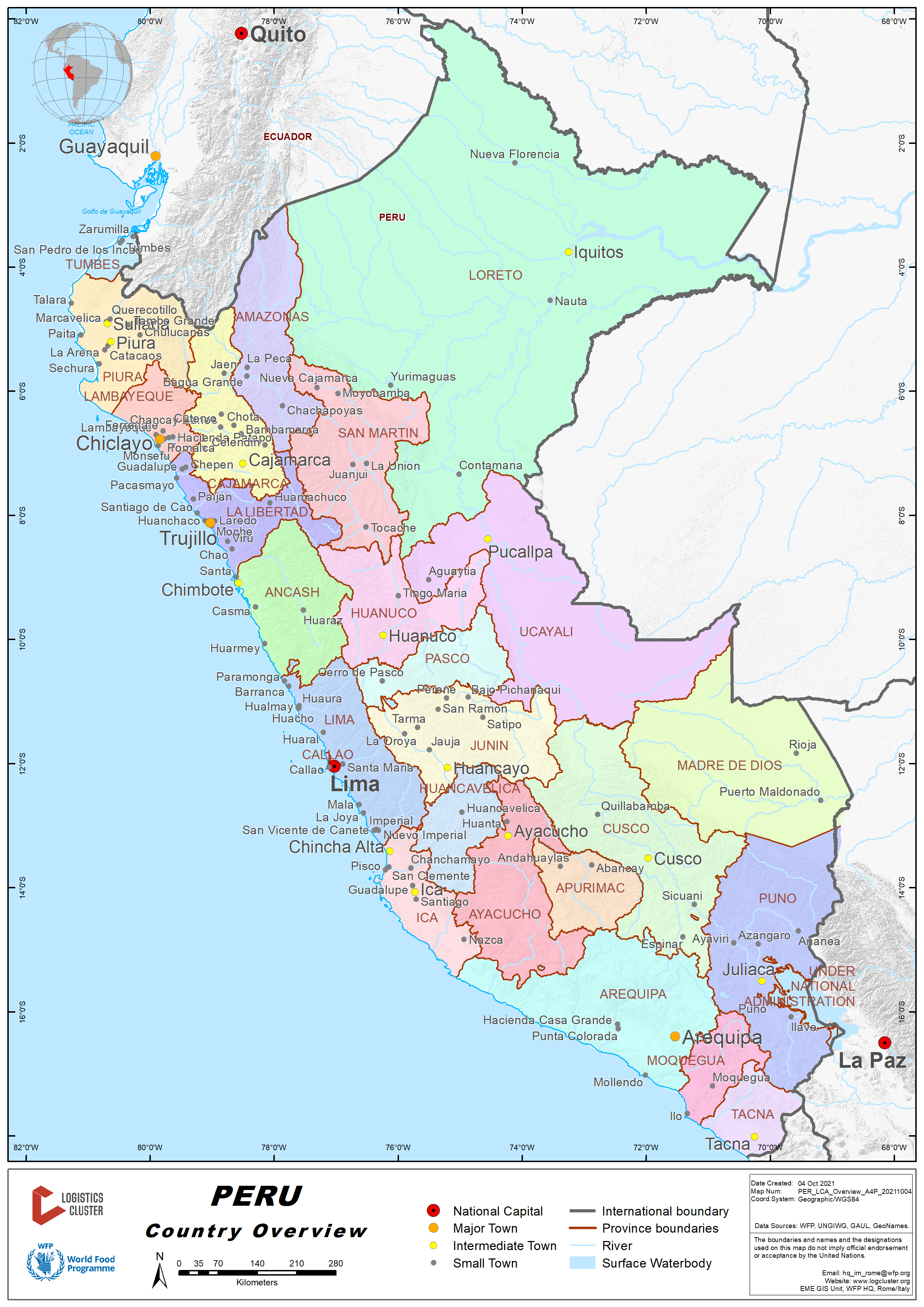
Overview
Infrastructure in Peru began to develop rapidly thanks to the economic growth that the country had at the beginning of the 90's. By giving many of the ports and airports under concession to private companies, these concession companies greatly improved the infrastructure and the quality of services. Bringing them to international standards regarding services as well as new technology and machinery. In the part of air infrastructure or airport network of Peru, it is made up of 97 aerodromes, 11 of which are international and 86 are national or private. The airport concessionaires have the following distribution: Lima Airport Partner 1, Aeropuertos Del Peru 12, Aeropuertos Andinos 5, Corpac 29, other domestic and / or private operators 50.
It is important to highlight that Peru manages to connect the Pacific and Atlantic oceans through a series of land and river routes. Currently, it has 62 ports, 45 of which are maritime, 11 river and 6 in lake, and the most important are the Salaverry Multipurpose Port Terminal, Ilo Moquegua Port Terminal, General San Martín Port Terminal - Paracas, Pisco, Yurimaguas Port Terminal – Nueva Reforma, Multipurpose Terminal Muelle Norte - Callao, Lima.
The existing National Road Network consists of a total of 27,109.6 km (21,434.0 km of Paved Roads and 5,675.5 km of Unpaved Roads). The Departmental Highway Networks have a total of 27,505.6 km of Roads (They are 3,623.1 km Paved and 23,882.5 km Not Paved). The Neighbourhood Roads Networks have a total of 113,857.9 km (They are 1,858.9 km Paved and 111,999 km Not Paved).
The Railway Network in Peru consists of a total of 1,939.7 km. Of which we have 188.7 km of the Public Network, 1,512.4 km of the Public Concession Network, and the Private Network 238.6 km. The 33.1 km of the Lima Metro is not considered, since it is not interconnected to any network, it only fulfills the role of mass transport and depends on the Autonomous Electric Train Authority.
The Ministry of Transportation and Communications has prepared the Transportation Logistics Services Development Plan. This Plan is conceived as a tool for analysis, evaluation, planning and promotion that will enable to face the main challenges posed to the Peruvian transportation, logistics and industry sectors in order to enhance their future competitiveness.
The Transport Logistics Services Development Plan aims to:
- Design the strategic development framework for a sustainable and efficient logistics scheme that utilizes and logically integrates Peru's specific potential and facilitates the competitiveness and attractiveness of national products;
- Define, in coherence with the previous point, the needs for the development or evolution of logistics centers and platforms, integrating the existing elements in the different modes of transportation, in order to propose and plan a network of infrastructure and logistics services integrated over the Peruvian territory;
- To help develop and consolidate an advanced integrated and intermodal logistics offer and infrastructure in the different strategic nodes of Peru, as centers with potential for value-added logistics services and activities.
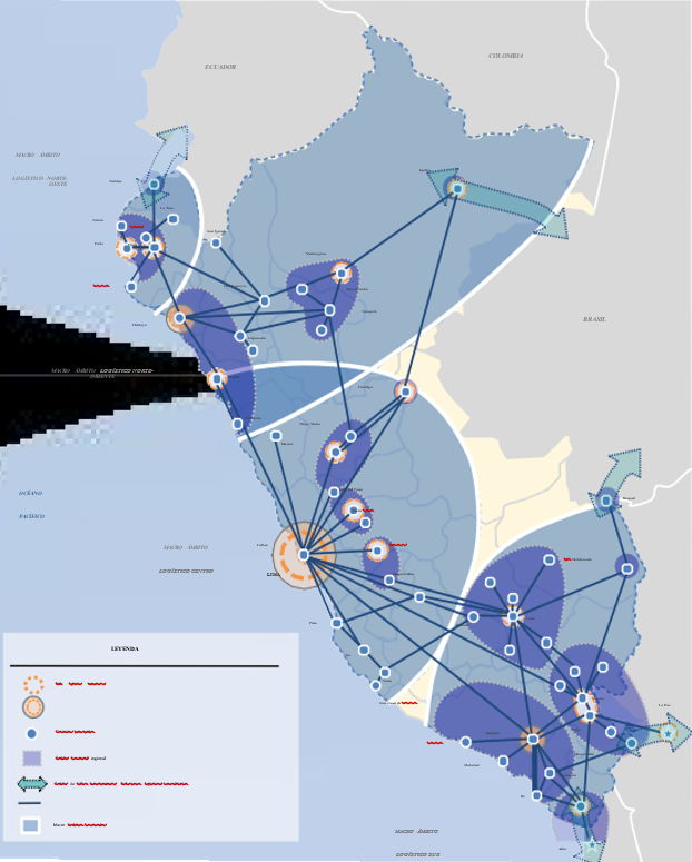
Logistics Services System in Peru
Conceptual outline of development. The diagnosis of the Peruvian logistics system has shown that although the needs of domestic logistics chains are important, the Peruvian system is currently positioned -and effectively serving- global logistics chains. In particular, the logistics and port supply of El Callao stands out. The size of the hinterland, the country's significant efforts to modernize port infrastructure, and the way demand and supply have reacted have made Callao a second-ranking port hub in the Pacific.In summary, Peru's current functional model presented in the diagnostic phase is as follows:
- Regarding to the first-tier logistics nodes, the Lima-Callao node is predominant in the national logistics context. This center organizes the trunk distribution activity to the south and north of Peru, in addition to acting as a capillary distribution node for the central regional area. The new port infrastructure of Lima-Callao has consolidated its role as a secondary maritime hub in the Pacific, and this trend is likely to continue. In the north of the country, there are three second-tier nodes: Trujillo, Chiclayo -which serves as a hub for the logistics axis to Yurimaguas and Iquitos- and the Paita-Piura nodal pair, mainly linked to the port. In the southern region, the main node is Arequipa, which operates as a regional distribution center for goods to Juliaca-Puno, Cusco, Moquegua-Ilo, Tacna, etc. The eastern region of the country has strong Amazonian-trans-Andean links, particularly from Iquitos to Yurimaguas and Pucallpa, and from there to Tingo María-Huánuco and Lima; also, from Puerto Maldonado to Cusco and Juliaca-Puno. Finally, there are areas of cross-border trade based on foreign trade operations with neighboring countries by road (Tumbes, Tacna, Desaguadero, and Iñapari).
- All of the above translates into the existence of four logistic basins: the Central Logistics Macro-area, which includes the activity of the Lima-Callao node and the activity of the Sierra-Centro with the former; the Southern Peru Logistics Macro-area, centered on the Arequipa node and with the complementary nodes of Juliaca-Puno, Cuzco and Tacna, which include links with Brazil, Bolivia and Chile through the border centers of Iñapari, Desaguadero and Santa Rosa; The North-West Logistics Macro-area includes the Paita-Piura logistics axis and the border relationship with Ecuador; and finally, the North-East Logistics Macro-area, with the center of gravity in the Chiclayo node as the main articulator, and which includes relations with Trujillo and towards the East with Yurimaguas and Iquitos, from where the fluvial relationship with Brazil is organized.
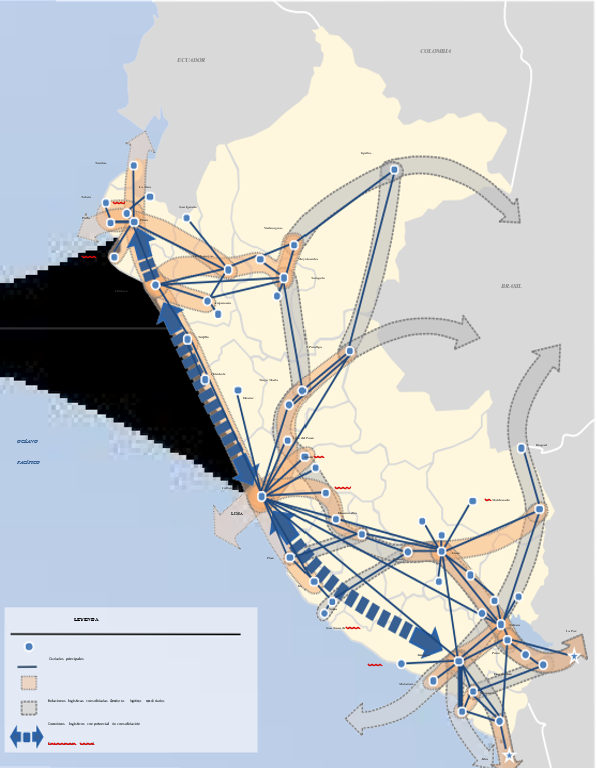
- Finally, there are two national structuring axes focused on Lima-Callao, which organizes activity towards the north coast and along the south coast to Arequipa, parallel to the coast along the Pan-American Highway by road. There is no complementarity with the railroad mode despite its high traffic rates. There are also secondary consolidated logistics corridors and others with consolidation potential that could improve efficiency in Peru's logistics chains. In the Southern Region there are consolidated logistics axes, and the opportunities for consolidating relations derive from the IIRSA South and the development of transportation infrastructure and services; which will contribute to the consolidation of the Ilo-Moquegua-Desaguadero, Abancay-Nazca, Arequipa-Tacna, etc. axes. In the north, the Chiclayo-Chachapoyas-Tarapoto-Yurimaguas axis is consolidated and will be complemented with the consolidation of the Paita-Piura-Yurimaguas axis. The axis connecting Iquitos with Yurimaguas and Pucallpa has the potential for future consolidation by improving river transport services between the two.
Based on the above analysis and the national freight transportation model developed, 22 logistics corridors and a main node, Lima-Callao, have been identified, along which most of Peru's freight traffic moves. The table below shows the codification and description of each of the logistics corridors identified.
| Identified Logistics Corridors | |||
|---|---|---|---|
| No. | Code | Name | Description |
| 1 | EE01 | Structuring Axis 01 | Lima to Piura (Panamericana Norte) |
| 2 | EE02 | Structuring Axis 02 | Lima to Arequipa (South Pan-American Highway) |
| 3 | CL01 | Logistics Corridor 01 | Chiclayo - Moyobamba - Tarapoto - Yurimaguas - Iquitos |
| 4 | CL02 | Logistics Corridor 02 | Paita - Piura - Dv. Olmos |
| 5 | CL03 | Logistics Corridor 03 | Lima - La Oroya - Huánuco - Tingo María - Pucallpa |
| 6 | CL04 | Logistics Corridor 04 | Nazca - Abancay - Cusco |
| 7 | CL05 | Logistics Corridor 05 | Matarani - Arequipa - Juliaca - Pte. Inambari |
| 8 | CL06 | Logistics Corridor 06 | Arequipa - Moquegua - Tacna - La Concordia (Border with Chile) |
| 9 | CL07 | Logistics Corridor 07 | Matarani - Ilo - Moquegua - Desaguadero (Border with Bolivia) |
| 10 |
CL08 |
Logistics Corridor 08 | Cusco - Puerto Maldonado - Iñapari (Border with Brazil) |
| 11 | CL09 | Logistics Corridor 09 | Ayacucho - Pisco |
| 12 | CL10 | Logistics Corridor 10 | La Oroya - Huancayo - Ayacucho - Abancay |
| 13 | CL11 | Logistics Corridor 11 | Cusco - Juliaca - Puno - Desaguadero (Border with Bolivia) |
| 14 | CL12 | Logistics Corridor 12 | Tarapoto - Aucayacu - Tocache - Tingo María |
| 15 | CL13 | Logistics Corridor 13 | Pativilca - Conococha - Huaraz - Carhuaz |
| 16 | CL14 | Logistics Corridor 14 | Ciudad de Dios - Cajamarca - Chachapoyas |
| 17 | CL15 | Logistics Corridor 15 | Piura - Tumbes - International Bridge (Border with Ecuador) |
| 18 | CL16 | Logistics Corridor 16 | Chiclayo - Cajamarca |
| 19 | CL17 | Logistics Corridor 17 | La Oroya - Tarma - La Merced - Satipo |
| 20 | CL18 | Logistics Corridor 18 | Chimbote - Huacrachuco - Tocache |
| 21 | CL19 | Logistics Corridor 19 | Salaverry - Trujillo - Shorey - Huamachuco |
| 22 | CL20 | Logistics Corridor 20 | Dv. Quilca - Matarani - Ilo - Tacna |
| 23 | NP01 | Principal Node 01 | Metropolitan Area of Lima and Callao |
The description of the conceptual model of logistics development, the best alternative being a mixed development model (international-domestic). For this purpose, it is necessary to describe in more detail the selected model. The mixed model of development of the national logistics system, as its name suggests, is a model that combines the development of all components of the logistics system - infrastructure, services and processes - in support of the international market for these services and the domestic market.
The international market segment demands very efficient infrastructure and services in the border nodes -maritime, air and land-, with very attractive costs and quality for the user of the international physical distribution system. In general, the logistics services offered here are complementary to the foreign trade (border) activity, and the logistics processes are those usually included under the denomination "trade and transport facilitation" (see Table N° 2 below).
The domestic market segment, on the other hand, demands infrastructure to support domestic distribution of goods and urban or last mile logistics. Services are associated either with support for the preparation of products for final consumption or for their export.
Components to be developed in a Mixed Logistics Model
Infrastructure
- Ports and airports well integrated to the global cargo distribution network.
- Network of logistics platforms associated with the main foreign trade nodes.
- Trunk cargo highways
- Road border crossings
- Logistics infrastructure to support maritime, air and land border operations.
- Specialized nodal infrastructure to support distribution and last-mile logistics
- National network of truck centers on concessioned roads
- Secondary road networks serving national trunk movements
- Tertiary networks providing access to major rural production centers
Services
- International quality standards
- Consolidation and deconsolidation
- Warehousing under customs custody of goods in transit or under temporary regime
- Service to empty containers
- International transportation
- Cross-docking,
- Customs brokerage and freight forwarding
- Cold storage facilities, Service to international carriers
- Packaging
- Palletizing and unitizing
- Labeling
- Warehousing and inventory management
- Cross-docking
- Express parcels
- Return logistics
- Transportation, removals and deliveries
- Postponement
- Assembly
- Transportation and refrigerated facilities
- Order preparation
- Purchasing and invoicing
Processes
- Simplification of customs procedures, harmonization of border procedures and single windows for foreign trade.
- Reduction of non-tariff barriers applicable to the transportation sector (standardization of limits, weights and dimensions, transit facilitation for third-country operators).
- Security management and security monitoring
Domestic market segment
- Cargo tracking
- Customer service and return logistics management
- Freight exchanges
- Training and professional certification processes.
- Information and dissemination system.
- Logistics observatory
The main objective of defining these scopes has an impact on the prioritization of investments, the definition of the system's management and promotion model, the institutional model to be adopted and the roles of the public and private sectors. The adoption of the mixed model implies that the State is involved in the active promotion of all the components of the system and not only, as has been the case to date in Peru, in the components of the system aimed at serving the last stages or links in the foreign trade logistics chains.
The standards to be met by the system are necessarily linked to the relative hierarchy of the system's components. These standards are related not only to capacity and quality, but also to the comprehensiveness of the solution.
This means, for example, that investment in high-capacity port infrastructure alone is not enough to ensure a high standard; such a standard would be ensured with a smooth and efficient integrated system: fluid access, segregation of local flows from international flows, adoption of state-of-the-art information technologies to ensure port movement. A port that does not have the relevance of El Callao would not need to meet such high standards, not only because the demand is lower, but also because the investments involved are also lower.
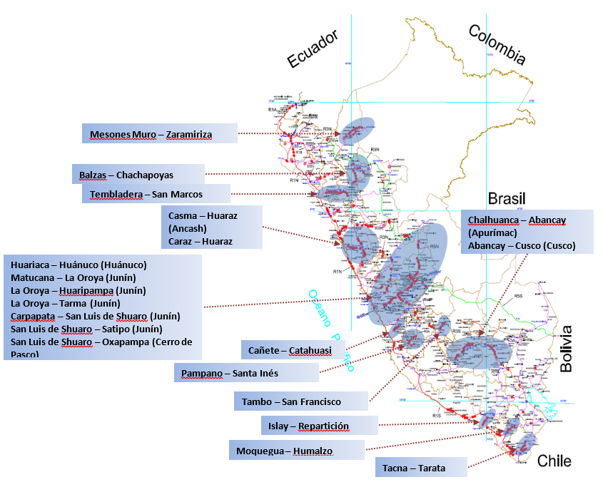
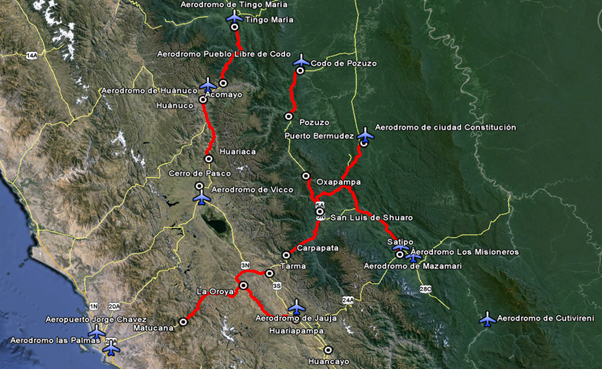
HISTORICAL MAP OF CRITICAL POINTS OF THE NATIONAL ROAD NETWORK
According to the map of critical points that the Ministry of Transport and Communications has identified through Provias, the sections of the national road networks, with high probabilities of being affected by natural phenomena (landslides, mudslides and platform erosion) are concentrated in the central zone from the country.
CENTER ZONE - National Road Network and Aerodromes
The figure shows the national road network (Center), highlighting the potential sections to be considered as part of a potential air bridge, as well as the aerodromes that could serve as the axis of said air bridges.
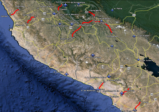
SOUTH ZONE - National Road Network and Aerodromes
The figure shows the national road network (South), highlighting the potential sections to be considered as part of a potential air bridge, as well as the aerodromes that could serve as the axis of said air bridges.
2.1 Peru Port Assessment
2.1 Peru Puerto de Matarani (Español)
Descripción general del puerto
El Puerto de Matarani está ubicado en el distrito de Islay en Islay, Arequipa, Perú. Constituye uno de los tres puertos del Pacífico Sur peruano por donde sale la carretera interoceánica hacia el sur del Perú y los países vecinos de Brasil y Bolivia, interconectando por estas vías el atlántico brasileño.
Este puerto se está consolidando como una alternativa para los cruceros que operan en la costa del Pacífico Sur, permitiendo a los viajeros conocer los principales atractivos turísticos de Arequipa. En el 2018, el movimiento portuario en el puerto de Matarani fue de 22,192 TEUs ubicándose en el puesto 90 en la lista de actividad portuaria de América Latina y el Caribe.
Sitio web del puerto: https://www.tisur.com.pe/es
Información importante del puerto también puede encontrarse en: http://www.maritime-database.com
|
Contacto y ubicación del puerto |
|
|
País |
Perú |
|
Provincia o Distrito |
Islay, Matarani |
|
Pueblo o ciudad (más cercana) con distancia (km) |
Distancia desde el Puerto de Matarani a ciudad de La Paz. Carretera: 586 km |
|
Nombre completo del puerto. |
Puerto de Matarani. |
|
Latitud. |
-17.00048 |
|
Longitud. |
-72.10637 |
|
Entidad administradora o autoridad portuaria (si hay más de un operador, desglosar por zona de operaciones). |
Terminal Internacional del Sur (TISUR). |
|
Persona de contacto encargada de administración. |
TISUR: Gabriel Monge Aguirre, Gerente General. Javier Calderón, Gerente de Operaciones.1 |
|
Aeropuerto más cercano y Aerolíneas frecuentes desde/hacia destinos. |
Nombre del Aeropuerto: Aeropuerto Internacional de Arequipa Rodríguez Ballón. Aerolíneas: LATAM Airlines, SKY Airlines, Jet Smart, Viva Air. Operan en vuelos nacionales e internacionales (Chile).2 |
Foto del puerto
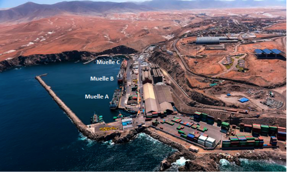
- Muelle A y B
Naves de 250 mts de eslora. Calado 10 m.
- Muelle C
Naves de 250 mts de eslora. Calado 10 m.
- Muelle F
Naves de 205 mts de eslora. Calado 18 m.
Descripción y contactos de empresas clave
TISUR; Terminal Internacional del Sur S.A., una empresa perteneciente al Grupo Romero, creada con el objetivo de promover el desarrollo económico en la región sur, sus principales servicios son: exportación/importación, cabotaje, recepción/almacenamiento de minerales, equipo para movimiento de carga.
Para mayor información sobre contactos de puertos, por favor referirse al siguiente link: 4.4 Bolivia Lista de Contactos de Empresas Portuarias
Desempeño del Puerto
La Terminal Portuaria de Matarani tiene una ubicación estratégica en la costa oeste de América del Sur, donde llega la carga, a través de una moderna carretera, apropiada para el tránsito de vehículos de carga pesada. Esta vía es rápida y segura, y forma parte de la carretera interoceánica que une por el este a Brasil y por el sur a Bolivia.
El 2016, el puerto de Matarani exportó 5 millones de toneladas entre granos (como cebada) y mineral gracias al nuevo muelle (F) de embarcación de minerales (concentrado de cobre). Se registraron similares cifras los años posteriores.
Con ello, esta terminal se convirtió en el más importante del sur del país por los almacenes de concentrado de cobre que se construyeron para las empresas Antapacay, Cerro Verde y Las Bambas. Desde estos depósitos, el mineral es embarcado hacia China, el principal comprador.
|
Restricciones Estacionales |
||
|
|
Si / No |
Período de tiempo |
|
Temporada de lluvias |
No |
El área es desértica. |
|
Campañas de importación importantes |
No |
|
|
Inserte otra(s) restricción(es) si es necesario. |
n/a |
|
|
Manejo de cifras año 2018 |
|
|
Escalas de barcos comerciales |
533 |
|
Tráfico de contenedores (TEU´s) |
22.192 |
|
Manejo de cifras de cargas a granel y cargas surtidas año 2017 |
|
|
A granel (TM) |
6,188.889 |
|
Carga Surtida (TM) |
378.333 |
Tarifas de descarga y gastos de manipulación en las terminales
- Tarifario vigente a partir del 17/08/2018
- Procedimiento de aplicación de tarifas
- Tarifas reguladas vigentes a partir del 17/08/2018
- Tarifas no regulas vigentes a partir del 17/08/2018
- Tarifas de carga en tránsito vigentes a partir del 17/08/2018
- Tarifas de contenedores vigentes a partir del 17/08/2018
- Tarifas de contenedores en tránsito a Bolivia vigentes a partir del 17/08/2018
- Descuentos vigentes a partir del 17/08/2018
Especificaciones de atraque
|
Tipo de atraque |
Cantidad |
Longitud (m) |
Calado máximo (m) |
Comentarios |
|
Atraque convencional |
3 |
583 |
10 |
En uso continuo |
|
Muelle de contenedores |
2 |
389 |
10 |
En uso continuo |
|
Atracadero de barcos graneleros |
3 |
583 |
10 |
En uso continuo |
|
Atraque de remolcadores |
Desconocido |
n/a |
n/a |
n/a |
|
Barcazas de agua |
No dispone |
n/a |
n/a |
n/a |
Muelles de carga general
|
Tipo de Carga |
Identificación de Muelle |
|
Importaciones – Carga en bolsas |
Muelle marginal, múltiples operaciones |
|
Exportaciones – Carga en Bolsas |
Muelle marginal, múltiples operaciones |
|
Importaciones y Exportaciones – Ro-Ro |
Un muelle de 36 mts de largo, 24 mts de ancho y 28 pies de calado. |
|
Otras Importaciones |
Muelle C, F |
Equipo de manipulación portuaria
A través de una moderna infraestructura, amplias áreas de operaciones y equipos adecuados, TISUR maneja diferentes tipos de carga en grandes volúmenes: mercadería general, gráneles sólidos, líquidos, carga rodante, contenedorizada y refrigerada.
|
Equipo |
Disponibilidad (Si / No) |
Cantidad total y capacidad disponible |
Comentarios sobre el actual y el uso real |
|
Grúas de muelle |
Si |
2 unidades, Grúa Gottwald modelo HMK 280 = 63 TM. Grúa Liebher LHM 400 = 100 TM. |
En uso continuo |
|
Grúas Puente de contenedores |
No |
n/a |
n/a |
|
Grúas móviles portacontenedores |
Si |
2 unidades, Grúa Clamshell = 300 TM/h. Grúa Terex = 50 TM5 |
En uso continuo |
|
Reachstacker |
Si |
Desconocido |
En uso continuo |
|
Ro-Ro Tugmaster (con remolque) |
Si |
Un muelle de 6 mts de largo, 24 de ancho y 8,40 de calado. |
En uso continuo |
|
Elevador de granos con máquinas embolsadoras |
Si |
2 unidades, Torre Vigan = 400 TM/h. Torre Bulher = 200 TM/h. |
En uso continuo |
|
Carretillas elevadoras |
Si |
17 unidades, hasta 15 TM c/u. |
En uso continuo |
Instalaciones para el manejo de contenedores
Servicios:
- Manipuleo de contenedores.
- Transferencia de contenedores.
- Zona de Stacking.
- Consolidación y Desconsolidación.
- Almacenamiento de contenedores (llenos/vacíos).
- Reparación de contenedores.
- Suministro de energía para contenedores refrigerados.
- Montaje y desmontaje de Gen Set.
La Terminal de Contenedores tiene un área de 22.192,21 m2 distribuidos en:
- Depósito de Llenos: Con un área de 14,264.89 m2 y capacidad de 1,648 TEUs para la atención de contenedores secos y refrigerados, así como con 50 tomas de energía, existiendo áreas de consolidación y desconsolidación.
- Depósito de Vacíos: Con un área de 7,847.32 m2 y capacidad de 980 TEUs.
- Zona de Mantenimiento de Contenedores: Zona especializada para el lavado de contenedores y reparación de vacíos
|
Instalaciones |
20 ft |
40 ft |
|
Instalaciones de contenedores disponibles |
Área de 22.192,21 m2 para contenedores llenos y vacíos. |
|
|
Estación de carga y descarga de contenedores (CFS) |
Área terminal de contenedores de 22.000 m2. |
|
|
Estación de carga y descarga de contenedores refrigerados (CFS) |
Área terminal de contenedores de 22.000 m2. |
|
|
Otros datos de capacidad (contenedores al año) |
Capacidad anual de 300.000 contenedores. |
|
|
Capacidad
diaria |
Capacidad diaria de 822 contenedores. |
|
|
Número de estaciones de
frigoríficos |
50 puntos de conexión |
|
Guía de aduanas
La carga Bolivia que llega o sale del puerto Arica, se tramita a través de la Administradora de Servicios Portuarios Bolivia (ASPB), que es el Agente Aduanero del Estado de Bolivia.
Importaciones:
- Recepción, verificación, custodia, control, almacenamiento y certificación de todo tipo de mercancías y/o bienes en tránsito hacia Bolivia.
- Estiba y desestiba de carga.
- Porteo y acopio en almacén.
- Planificación de despacho de carga a destino y en la empresa de transporte elegida por el consignatario.
- Almacenamiento sin costo por 365 días en Arica y Antofagasta, excepto carga peligrosa (IMO).
Exportaciones:
- Planificación e internación de mercancía al Puerto.
- Recepción, verificación, custodia, control y elaboración de la Póliza de Tránsito (Antofagasta y Arica).
- Consolidación de la mercancía.
- Traslado a la zona de stacking en coordinación con las navieras y el transporte terrestre.
- Envío de documentos al exportador.
- Almacenamiento sin costo por 60 días en los puertos de Arica y Antofagasta, excepto carga peligrosa (IMO).
Para mayor información sobre contactos de aduana en Bolivia, por favor referirse al siguiente link: 1.3 Bolivia Información Aduanera
Información de terminales
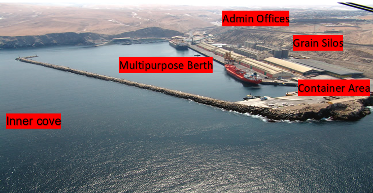
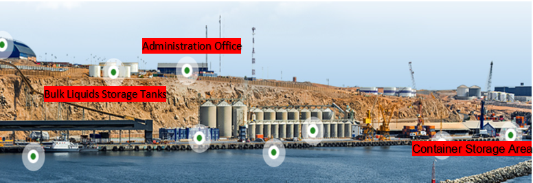
Terminal multipropósito
Equipos especializados, maquinaria e infraestructura y sistemas completamente automatizados que permiten manejar diferentes tipos de graneles, fertilizantes, cereales, minerales, carbón, clinker, sal industrial, etc.
Muelle Marginal: Utilizado para el amarre directo de buques, se encuentra orientado al noreste, construido de concreto; tiene 583.10 metro de largo por 20 metros de ancho y está dragado a 9.15 metros sobre el nivel medio del mar. El muelle está dividido en tres amarraderos que se emplean para manipular carga en general.
Las instalaciones de la Terminal Marítima tienen almacenes para carga general, silos para almacenamiento de granos, depósito para minerales, equipo de transporte de carga, grúas con fuerza de hasta 50.000 libras, torre neumática para la recepción de granos a granel y equipo de embarque de mineral a granel.
Muelle de Cabotaje: En el lado SW del puerto y adosado al Muelle Marginal, hay un pequeño muelle, de tipo marginal, para embarcaciones menores, que tienen aproximadamente 50 mts. de largo, frente al cual existe otro muelle similar, pero de mayor longitud.
Muelle Pesquero: En lado Este del puerto y contiguo al rompeolas existe un tercer muelle, también del tipo marginal utilizado por embarcaciones menores de pesca, construido de concreto y tiene 90.50 mts. de longitud por 25 mts. de ancho. Este muelle cuenta con almacenes frigoríficos y con una máquina para producir hielo.
Terminal de almacenamiento principal
|
Tipo de almacenamiento |
Número de instalaciones de almacenamiento |
Área (m2) |
|
Carga en bolsas/sacos |
59 silos con capacidad estática de 75.000 TM |
Desconocido |
|
Carga refrigerada |
50 puntos de conexión |
n/a |
|
Carga general |
Áreas de almacén techado Áreas de almacén para contenedores |
22.218 36.749 |
|
Minerales |
Amarradero C = 125.000 TM Amarradero F = 300.000 TM |
Desconocido |
|
Gráneles líquidos |
5 tanques con capacidad de 9.900 m3 |
n/a |
Estiba y desestiba
Entidades que ofrecen el servicio:
- https://www.aspb.gob.bo/
- Trabajos Marítimos S.A.
- Transuniversal Estibas S.A.C.
- Cosmos Agencia Marítima S.A.
Información de zonas del interior
La Terminal Portuaria de Matarani tiene una ubicación estratégica en la costa Oeste de América del Sur, donde llega la carga, a través de una moderna carretera, apropiada para el tránsito de vehículos de carga pesada. Esta vía es rápida y segura, y forma parte de la carretera interoceánica que nos une por el este a Brasil y por el sur a Bolivia.
Seguridad portuaria
|
Seguridad |
|
|
Cumplimiento de las normas ISPS (PBIP) |
Si |
|
Nivel actual de ISPS. (Código internacional para la protección de los buques y de las instalaciones portuarias). |
n/a |
|
Botes patrulleros |
Si |
|
Camiones de bomberos |
Si |
Información de apoyo
- Terminal Internacional del Sur (TISUR)
- TISUR, Informe Ambiental 2017
- TISUR, Reporte de Sostenibilidad 2015 - 2016
- Autoridad Portuaria Nacional del Perú
2.1.1 Peru Port of Matarani (English)
Port Overview
On August 18, 1999, the Peruvian State, through the MTC, awarded the Matarani Port Terminal for thirty years, through the concession contract for its construction, conservation and exploitation to Terminal Internacional Del Sur S.A. (Tisur), a company that successfully develops, manages and operates the terminal, also contributing to the development of the area, as it is the main logistics support in the Southern Region of Peru.
Among the main products that are mobilized we have regional (mineral concentrate, copper cathodes, wheat, fish meal, used vehicles, billet, etc.) and Bolivians (soy, wheat, etc.); the cargo captured from Bolivia is due to the preference of the port compared to the port of Arica. This project has generated benefits for the towns of Mollendo, Matarani, Dean Valdivia, La Punta de Bombón Cocachacra, which are the Municipalities of the Province of Islay to which a percentage of the gross income of the concession is allocated.
Port website: www.tisur.com.pe
Key port information may also be found at: http://www.maritime-database.com
|
Port Location and Contact |
|
|---|---|
|
Country |
Peru |
|
Province or District |
Matarani – Islay – Arequipa |
|
Nearest Town or City with Distance from Port |
Arequipa (115.2 km) |
|
Port's Complete Name |
Terminal Portuario Matarani - Arequipa |
|
Latitude |
17°00’ 00” S |
|
Longitude |
76°06’ 23” W |
|
Managing Company or Port Authority |
Terminal Internacional Del Sur S.A. |
|
Management Contact Person |
Gabriel Monge Aguirre, General Manager TISUR S.A. +5154 598585 |
|
Nearest Airport and Airlines with Frequent International Arrivals/Departures |
Aeropuerto Internacional Arequipa Alfredo Rodriguez Ballon LatAm Airlines, Sky Airlines, Viva Air |
Port Picture
Description and Contacts of Key Companies
TISUR has operations areas and specialized teams to attend to the different types of cargo handled in the terminal. The services offered by TISUR are Fractional Cargo and Projects, Containerized Cargo Transportation, Mineral Concentrate Transportation and Bulk Cargo.
Ship Services:
- Mooring / Unmooring
- Mooring rental
Cargo Services:
- Use of Pier (Import, Export, Cabotage and Transhipment)
- Fractional load, Rolling load, Solid bulk cargo (cereals, fertilizers and minerals), Bulk liquid cargo,
- Unloading / boarding of passengers.
- Import storage in silos or Solid bulk cargo - cereals
Services:
- ARGOS MARINE EIRL
- CORPORACION DE PRACTICOS S.A.
- MARITIME & SERVICES S.A.C.
- WABISABI SHIP SUPPLY AND SERVICES S.A.C.
- LOYOLA ALVAREZ, JAIME E.I.R.L.
- NAUTILIUS S.A.
- AGENCIAS UNIVERSALES PERU S.A.
- ALDEBARAN PILOTES S.A.C.
- AGENCIA MARITIMA KENRICK DEL PERU S.A.
- PILOTOS DEL SUR SOUTH PILOTS S.A.
- MANUEL IZQUIERDO ZELADA EIRL
- TRAMARSA FLOTA S.A.
Towing Services Companies:
- INVERSIONES MARITIMAS CPT PERU (INMARSA)
- PETROLERA TRANSOCEANICA S.A.
- IAN TAYLOR PERU S.A.C.
- EMPRESA MARITIMA DEL PERU S.A.
- TRAMARSA FLOTA S.A.
- SVITZER PERU S.A.
For more information on port contacts, please see the following link: 4.4 Port and Waterways Companies Contact List.
Port Performance
In relation to traffic in the TPM, during 2020 a total of 426 ships were served, the ships being of type bulk carriers the most representative (64.3% of all ships). During 2020, the TPM handled a total of 6.1 million tons of cargo. It is worth mentioning that 83.7% of the volume total cargo mobilized during 2020 corresponds to solid bulk cargo, followed by fractional cargo (9.7%), liquid bulk cargo (3.5%) and containerized cargo (3.1%). For its part, the rolling load was almost nil, having mobilized 6 tons.
|
Seasonal Constraints |
||
|---|---|---|
|
Occurs |
Time Frame |
|
|
Rainy Season |
No |
From (January) to (March) |
|
Major Import Campaigns |
Yes |
From (September) to (December) |
|
Other Comments |
The export of minerals (Solid Bulk Cargo) has been the majority of cargo in 2020, being 5,077,699 MT. |
|
|
Handling Figures for 2020 |
|
|---|---|
|
Vessel Calls |
426 |
|
Container Traffic (TEUs) |
15,322 |
|
Handling Figures Bulk and Break Bulk for 2020 |
|
|---|---|
|
Bulk (MT) |
5,077,699 |
|
Break bulk (MT) |
589,552 |
Discharge Rates and Terminal Handling Charges
For information on port rates and charges, please see the following link: https://www.tisur.com.pe/es/tarifario
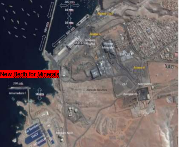
Berthing Specifications
|
Type of Berth |
Quantity |
Length |
Maximum Draft |
Comments |
|---|---|---|---|---|
|
Conventional Berth |
1 |
583 m |
10 m |
Berth w/ 3 moorings (A, B And C). Mooring A handles container shipments, fractional cargo and liquids. Mooring B handles general cargo, clean bulk and fertilizers. Mooring C handles shipments of minerals, clinker and fertilizers. |
|
|
1 | 280 m | 18 m |
Berth for minerals, F mooring just for minerals |
| Container Berth | N/A |
|
|
|
|
Silo Berth |
N/A |
|
||
|
Berthing Tugs |
N/A |
|
||
|
Water Barges |
N/A |
|
For the loading and unloading of Minerals,
Two Hermetic Tubular Belts with regimes of 1,500 and 2,000 TM / H.
The new Berth “F” for minerals start their services in 2018.
General Cargo Handling Berths
|
Cargo Type |
Berth Identification |
|---|---|
|
Imports - Bagged Cargo |
Multipurpose Dock - Import Cargo 1,747,156 MT |
|
Exports - Bagged Cargo |
Multipurpose Dock - Import Cargo 3,907,575 MT |
|
Imports and Exports - RoRo |
Multipurpose Dock – In 2020 only 6 MT of Import RoRo Cargo |
|
Other Imports |
For the loading and unloading of Minerals, Two Hermetic Tubular Belts with regimes of 1,500 and 2,000 TM / H. |
Port Handling Equipment
Thus, to provide the different types of services to the ships (mooring, unmooring and various services), as well as to the different types of cargo (solid bulk, liquid bulk, general cargo, rolling cargo and storage) and containers (handling, transfer, consolidation and deconsolidation, storage, repair, assembly and disassembly, among others), the concessionaire has equipment, vehicles and machinery to handle cargo and care for ships.
|
Equipment |
Available |
Total Quantity and Capacity Available |
Comments on Current Condition and Actual Usage |
|---|---|---|---|
|
Dockside Crane |
Yes |
1 Gottwald Crane model HMK 280 (Unloading capacity 63 MT) |
Good Condition |
|
Container Gantries |
No |
||
|
Mobile Cranes |
Yes |
1 Liebher Crane LHM 400 (Maximum Capacity 100 MT) 1 Terex Crane (Maximum Capacity 50 MT) |
Good Condition |
|
Reachstacker |
Yes |
1 Reach Stacker |
Good Condition |
|
RoRo Tugmaster (with Trailer) |
Yes |
6 Tugmaster |
Good Condition |
|
Grain Elevator with Bagging Machines |
Yes |
Two fully automated pneumatic absorbent towers: Torre Vigan- 400 Tm / h and Torre Bulher- 200 Tm / h. |
Good Condition |
|
Transtainer |
Yes |
4 Transtainers |
Good Condition |
|
Forklifts |
Yes |
4 Fork Lifts |
Good Condition |
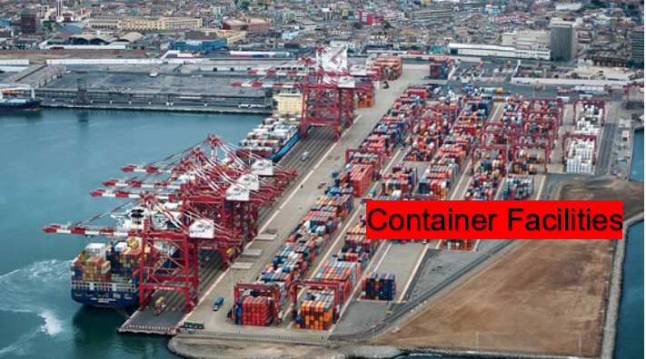
Container Facilities
The Tisur container terminal offers comprehensive services to imports, exports, cabotage and services for shipping lines as a warehouse. The Evergreen and Hapag Lloyd shipping lines operate on a regular schedule. Matarani Port also has handling equipment (Reach Stackers, elevators and mobile cranes), transfer, as well as storage, maintenance and operation areas with a capacity for 300,000 containers per year, both in dry and refrigerated cargo. Total container terminal area 22,000 square meters, of which 14,000 square meters are for full containers with a capacity of 1648 TEU's. For empty containers there is a designated area of 8,000 square meters with a capacity of 980 TEUs.
|
Facilities |
20 ft |
40 ft |
|---|---|---|
|
Container Facilities Available |
Yes |
Yes |
|
Container Freight Station (CFS) |
Yes |
Yes |
|
Refrigerated Container Stations |
Yes |
Yes |
|
Other Capacity Details |
||
|
Daily Take Off Capacity |
820 |
820 |
|
Number of Reefer Stations |
15 x 25 containers |
15 x 25 containers |
|
Emergency Take-off Capacity |
900 x day |
900 x day |
|
Off take Capacity of Gang Shift |
270 |
270 |
Customs Guidance
The SUNAT Customs offices are at the entrance to the Port of Paita (before the descent to the town), it offers all services and procedures. The hours of attention are according to office hours. In addition, as in all SUNAT offices, all imports are worked through systems (on line) of the customs itself.
For more information on customs in Peru, please see the following link: 1.3 Customs Information.
Terminal Information
Multipurpose Terminal
According to the statistics obtained in 2020, the TPM demonstrated that it is a multipurpose terminal and specializing more in bulk cargo (liquid and solid and mineral), Rolling Cargo, Containerized Cargo and Fractional Cargo. During 2020, the total number of ships served in the TPM amounted to 426 ships. These ships maintain the characteristic of being, for the most part, of the bulk carrier type.
In 2020, the TPM handled a total of 6.1 million tons of cargo. It is worth mentioning that 83.7% of the total volume of cargo mobilized during 2020 corresponds to solid bulk cargo, followed by fractional cargo (9.7%), liquid bulk cargo (3.5%) and cargo in containers (3.1%). For its part, the rolling load was almost nil, having moved only 6 tons. Container traffic reached 15,322 TEUs in 2020.
Likewise, most containers that move cargo are characterized by being of the 20-foot type, with a participation of 60.4%, reaching 6,698 during 2020. On the other hand, in 2020, the fractional cargo mobilized they were 589,552 tons. With regard to bulk cargo, solid cargo registered 5.1 million tons in 2020; while liquid cargo reached 211,469 tons during the year.
Grain and Bulk Handling
TISUR has two mineral reception, storage and shipment systems. This procedure is carried out with closed warehouses with a total of 420,000 static tons and conveyor belt systems that transfer the mineral concentrate to the warehouse with a nominal capacity of 2,000 and 1,500 tons / hr. The Port has specialized equipment, machinery, infrastructure and fully automated systems to handle different types of bulk. Solid bulks are discharged through pneumatic absorbent towers, silos with static capacity, and an underground conveyor belt; while liquid bulks, such as vegetable oil and alcohol, are handled thanks to a shipping system and tanks for storage service.
Main Storage Terminal
Due to the fact that the port handles more grains, fertilizers, minerals and it also has container movement but it is minimal, it has different areas to store these types of materials. The central roofed warehouse has 4,000 square meters, for grains (corn and wheat) it has 59 silos with a capacity of 75,000 MT. For the handling the mineral concentrate it has five warehouses with a storage capacity of 420,000 MT. It also has an area for container storage with a total of 22,000 square meters available.
|
Storage Type |
Number of Storage Facilities |
Area (m2) |
|---|---|---|
|
Bagged Cargo |
1 Warehouse |
4,000 |
|
Refrigerated Cargo |
N/A | |
|
General Cargo |
|
For Minerals: five warehouses 420,000 MT in total For grains: 59 silos with storage capacity of 75,000 MT For liquid bulk cargo: 5 tanks with a storage capacity of 9,900 cubic meters. Total Area for Containers: 22,000 square meters |
Stevedoring
In the Matarani Multipurpose Port Terminal, all stevedoring services are in charge of the same port. They handle all the internal services of the port; any need or requirement has to be communicated to the port administration. Due to the type of concession with the Peruvian state, the operator can offer the same all the regular, special and complementary services of the port, except the pilotage and towing of the ships that is provided by one of the associated companies of the port concessionaire, we refer to the company Tramarsa.
Hinterland Information
As is normal procedure in the ports in Peru, the containers leave the customs to bonded customs warehouses, where the goods are checked. This is at the choice of the importer / exporter who chooses where they can take their cargo. In the vicinity of the port there are several companies that offer this type of services and they are reliable companies. The movement of bulk cargo is collected from the dock of warehouses, silos or certain areas. But always in coordination with SUNAT customs, the movement of this type of merchandise is carried out.
Port Security
The Port of Matarani has good port security, applies a strict Access Regulation Policies to its facilities, has a private security service, has video surveillance cameras and also has a National Police station. It is governed by the security and safety guidelines and protocols required by the APN (National Port Authority), which apply to ports with services to any vessel.
|
Security |
|
|---|---|
|
ISPS Compliant |
Yes |
|
Current ISPS Level |
Level 2 |
|
Police Boats |
No |
|
Fire Engines |
No |
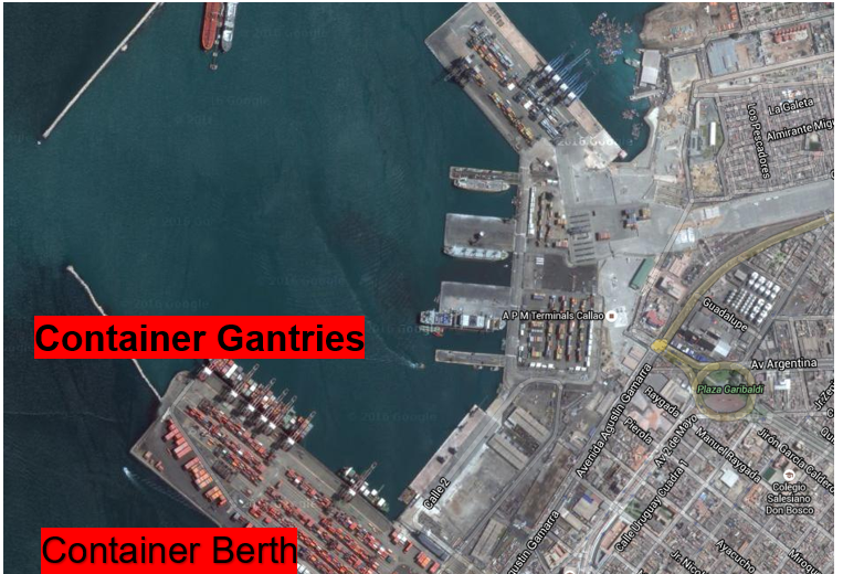
2.1.2 Peru Port of Callao - Terminal de Contenedores Muelle Sur
Port Overview
Port Overview
On July 24, 2006, the Ministry of Transport, Communications, and DP World Callao S.R.L, signed the Concession Contract for the design, construction, financing, conservation and operation of the New Container Terminal - South Zone. This contract is valid for 30 years. The terminal design includes the construction of a dock 960 meters long and 194 meters wide for containerized cargo. To date, the total investment committed for the development of the infrastructure is USD 627.4 million, being that the execution
It is divided into two stages: (i) the construction of two moorings of 300 meters each, as well as the availability of six gantry cranes; and, (ii) the expansion of the berthing front with an additional berth. The approval of the Phase I works (berth 1 and 2 and complementary works) were carried out in 2010. DP World, due to the nature of the cargo it handles, has shipping lines as its main clients. During 2020, the main companies that generated container traffic were the shipping lines Hapag-Lloyd, CMA CGM, China Shipping Container Line, and Evergreen with 33.3%, 20.9%, 13.9% and 8, 5%, respectively.
In 2020, the Terminal Muelle Sur reached 647 ships, 10.0% less than that registered in 2019 (719 ships). All the ships attended have the characteristics of being of the high board type and Gear Less. Regarding monthly traffic, the month with the highest number of ships attended was the month of November with 60 ships; while in the month of April the least amount arrived, registering 49 ships.
Port website: www.dpworldcallao.com.pe
Key port information may also be found at: http://www.maritime-database.com
|
Port Location and Contact |
|
|---|---|
|
Country |
Peru |
|
Province or District |
Callao |
|
Nearest Town or City with Distance from Port |
Lima (8.5 km) |
|
Port's Complete Name |
Terminal De Contenedores Muelle Sur - Callao |
|
Latitude |
-12.056914 |
|
Longitude |
-77.147580 |
|
Managing Company or Port Authority |
DP World Callao |
|
Management Contact Person |
Theodoros Van Den Heuvel, General Manager Av. Manco Cápac No. 113 – Callao, Callao - Perú Tel. +511 2066500 |
|
Nearest Airport and Airlines with Frequent International Arrivals/Departures |
Jorge Chavez International Airport LATAM, Viva Airlines, American Airlines, United Airlines, Delta Airlines, Avianca, Aerolineas Argentinas, Iberia, Lufthansa, Air France, KLM, Europa Air, Copa Airlines |
Port Picture
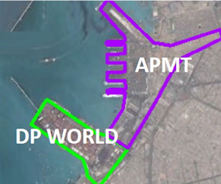
Two port concessions in the old Callao dock in Peru. DP World has the concession of Muelle Sur. APTMT has the concession of Muelle Norte.
Description and Contacts of Key Companies
The Services provided by DP World Callao, concessionaire of Muelle Sur are the following:
| Standard Services | |
|---|---|
| Ship Services |
|
| Cargo Services |
|
| Special Services | |
| Special temporary deposit service | |
| Additional Services | |
|
|
| Services | Companies |
|---|---|
| Practice Service Companies |
|
| Boat Towing Services Companies |
|
For more information on port contacts, please see the following link: 4.4 Port and Waterways Companies Contact List.
Port Performance
DP World has been operating for around 11 years in the New Container Terminal of the TPC. Being a terminal specialized in containerized cargo; its main clients are shipping lines. Thus, in 2020, the main clients were Hapag-Lloyd, CMA CGM, China Shipping Container Line, and Evergreen, which represented 33.3%, 20.9%, 13.9% and 8.5% of the total movement load, respectively.
In line with the international trend, an increase in the capacity of the ships, the number of ships served in the TMS has decreased, but the number of containers has increased. As happened in 2019, the reduction in the number of ships serviced it did not correspond to the higher volume of cargo handled, which increased by 0.8% between 2019 and 2020, going from 1,351.6 to 1,380.8 thousand TEUs. Thus, an increase in the average volume of cargo moved per ship is observed, which went from 1.88 thousand tons per ship in 2019 to 2.1 thousand TEUs per ship in 2020.
|
Seasonal Constraints |
||
|---|---|---|
|
Occurs |
Time Frame |
|
|
Rainy Season |
No |
From January to March |
|
Major Import Campaigns |
Yes |
From October to December |
|
Other Comments |
When the expansion of the third berth is completed, it is expected to have a daily movement of 3,400 TEU's or 1,200,000 or TEU's per year. The bottleneck is the traffic to the port of the South Pier, the containers are mobilized in trailers. The MTC is looking at the possibility of extending and enabling the railway line to the area of the two ports so that the containers enter the zone of the ports by this railroad. |
|
|
Handling Figures for 2020 |
|
|---|---|
|
Vessel Calls |
647 |
|
Container Traffic (TEUs) |
1,328,069 |
|
Handling Figures Bulk and Break Bulk for 2020 |
|
|---|---|
|
Bulk (MT) |
15,150,390 |
|
Break bulk (MT) |
N/A for this port, only containers |
Discharge Rates and Terminal Handling Charges
For information on port rates and charges, please see the following link:
https://www.dpworldcallao.com.pe/servicio/terminal-portuario/
|
Terminal De Contenedores Muelle Sur |
|||
|---|---|---|---|
|
Maximum Rates for Regulated Services as of 26 February 2021 (in USD, does not include 18% VAT) |
|||
|
Provider Entity: DP World Callao S.R.L. |
|||
|
Terminal South Spring of the Port Terminal of Callao |
|||
|
1. Standard Service to the Ship |
|||
|
Concept |
Collection Unit |
Amount |
Reference |
|
Use of mooring |
Meter of length / Hour or Collection fraction |
0.681 |
Concession Contract Annex 5 Resolution No.0002-2021-CD-OSITRAN |
|
2. Standard Service Load |
|||
|
Concept |
Collection Unit |
Amount |
Reference |
|
Shipping or unloading full 20 foot containers |
Per Container |
98.68 |
Concession Contract Annex 5 Resolution No.0002-2021-CD-OSITRAN |
|
Shipping or unloading full 40 foot containers |
Per Container |
150.16 |
Concession Contract Annex 5 Resolution No.0002-2021-CD-OSITRAN |
|
Shipping or unloading empty 20 foot containers |
Per Container |
43.16 |
Concession Contract Annex 5 Resolution No.0002-2021-CD-OSITRAN |
|
Shipping or unloading empty 40 foot containers |
Per Container |
84.97 |
Concession Contract Annex 5 Resolution No.0002-2021-CD-OSITRAN |
|
Transhipment of containers within the terminal (full or empty) full cycle - 20 ft container |
Per Full Cycle |
48.05 |
Concession Contract Annex 5 Resolution No.0002-2021-CD-OSITRAN |
|
Transhipment of containers within the terminal (full or empty) full cycle - 40 ft container |
Per Full Cycle |
68.9 |
Concession Contract Annex 5 Resolution No.0002-2021-CD-OSITRAN |
|
NOTE: The rates for other dimensions of containers will be adapted to 20 or 40 feet, as applicable. |
|||
Berthing Specifications
|
Type of Berth |
Quantity |
Length |
Maximum Draft |
Comments |
|---|---|---|---|---|
|
Conventional Berth |
N/A |
|
||
|
Container Berth |
1 |
650 m |
16 m |
They are working on the expansion of the third ship moorings, which are expected to end in 2022 |
|
Silo Berth |
N/A |
|
||
|
Berthing Tugs |
N/A |
|
||
|
Water Barges |
N/A |
|
They are working on the expansion of the
third ship moorings, which are expected to end in 2022. The dock
will even extend an additional 300 meters, leaving a total of 960
meters long and 194 meters wide, also equipped with 3 gantry cranes
for each mooring.
General Cargo Handling Berths
|
Cargo Type |
Berth Identification |
|---|---|
|
Imports - Bagged Cargo |
4,661,179 MT – Container Berth |
|
Exports - Bagged Cargo |
6,644,667 MT – Container Berth |
|
Imports and Exports - RoRo |
N/A |
|
Other Imports / Transhipments |
3,844,545 MT – Container Berth |
Port Handling Equipment
The South Zone Container Terminal of the Port of Callao It is a terminal specialized in the handling of cargo in containers. Currently, DP World has a Phase II of the South Zone planned, which includes an additional 310 meters of quay, 02 gantry cranes, 06 RTG yard cranes and the expansion of the storage area to 30.3 hectares. Likewise, it has additional investments contemplated for the extension of 90 more meters of dock, a new container storage yard, a new maintenance workshop, one (01) STS gantry crane, ten (10) RTG yard cranes. They only handle containerized cargo.
|
Equipment |
Available |
Total Quantity and Capacity Available |
Comments on Current Condition and Actual Usage |
|---|---|---|---|
|
Dockside Crane |
No |
||
|
Container Gantries |
Yes |
7 Units – 50 MT |
Good Condition |
|
Mobile Cranes |
Yes |
21 Units RTG – 45 MT |
Good Condition |
|
Reachstacker |
Yes |
2 Units 65 MT |
Good Condition |
|
RoRo Tugmaster (with Trailer) |
Yes |
38 Units – 45 MT |
Good Condition |
|
Grain Elevator with Bagging Machines |
No |
||
|
Transtainer |
Yes |
35 Units – 45 MT |
Good Condition |
|
Forklifts |
Yes |
3 Empty Handlers – 45 MT |
Good Condition |
Container Facilities
The container area or yard has an area of 140,000 square meters and a storage capacity for 850,000 TEUs per year.
|
Facilities |
20 ft |
40 ft |
|---|---|---|
|
Container Facilities Available |
Yes |
Yes |
|
Container Freight Station (CFS) |
Yes |
Yes |
|
Refrigerated Container Stations |
Yes |
Yes |
|
Other Capacity Details |
||
|
Daily Take Off Capacity |
3000 |
3000 |
|
Number of Reefer Stations |
600 |
600 |
|
Emergency Take-off Capacity |
3500 |
3500 |
|
Off take Capacity of Gang Shift |
1200 |
1200 |
Customs Guidance
The SUNAT Customs office is inside the Port of Callao. The Maritime Customs provides customs services throughout the year, the port works 24 hours every day of the year. Customs procedures for import / export of cargo via sea but in containers. These are loaded and unloaded in the bonded warehouses of customs and in these warehouses the goods are cleared or loaded to the importers.
For more information on customs in Peru, please see the following links: 1.3 Customs Information and www.sunat.gob.pe.
Terminal Information
Multipurpose Terminal
The Muelles Sur Port Terminal only works with cargo in containers, as stipulated in its concession contract with the Peruvian State. Having had a total movement in 2020 of 1,328,069 TEU's.
Grain and Bulk Handling
The Muelles Sur Port Terminal does not handle grain and bulk cargo, as we have only mentioned all cargo is containerized.
Main Storage Terminal
The Muelles Sur Port Terminal has the esplanade on the dock and the containers that load and unload from the vessels are stored there. The containers that are going to be cleared are taken out of the port to an bonded customs warehouse, where import and / export procedures are carried out.
|
Storage Type |
Number of Storage Facilities |
Area (m2) |
|---|---|---|
|
Bagged Cargo |
N/A | |
|
Refrigerated Cargo |
Refrigerated Containers |
4,000 |
|
General Cargo |
General Containers |
10,000 |
Stevedoring
The Muelles Sur Port Terminal offers the loading and unloading services of the ships, these stowage tasks are provided by the same DP World Callao port concierge, they provide all these services according to the rates published by OSITRAN.
Hinterland Information
In the Muelles Sur Port Terminal, containers cannot be cleared, both for imports and exports, these storage services in bonded warehouses are used for this type of customs paperwork. Leaving the port already in these warehouses they offer this type of services such as stowage, change, filling of containers as well as import and / or export customs duties.
Port Security
The Muelle Sur del Callao has one of the most effective security systems in the country, in relation to port security. How much with surveillance cameras, throughout the port, surveillance personnel in all facilities, there is a national police station, scanner for the review of containers with dangerous cargo or narcotics, it also has a detection system for nuclear materials and radiological substances.
|
Security |
|
|---|---|
|
ISPS Compliant |
Yes |
|
Current ISPS Level |
Level 2 |
|
Police Boats |
No |
|
Fire Engines |
No |
2.1.3 Peru Port of Paita
Port Overview
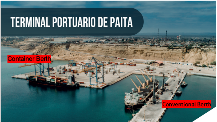
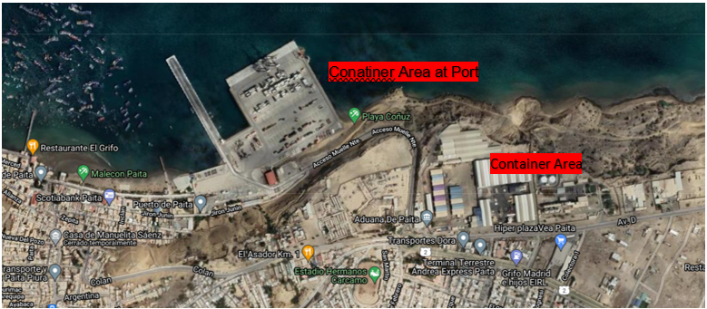
The port of Paita is the main port in northern Peru, mobilizing import and export containers (mainly hydrobiological and agricultural products) and general cargo. It is the second national port, after Callao, in terms of container movement and the fifth in total cargo movement.
In the first quarter of 2009, it was granted to the Portuguese-Peruvian consortium Terminales Portuarios Euroandinos (TPE), which signed the contract in September of that year. In 2018, the port movement in the port of Paita was 274,151 TEU, ranking 42nd on the list of port activity in Latin America and the Caribbean. Due to its geographical location the port determines as the natural zone of influence to the northern regions of the country such as Amazonas, Cajamarca, Lambayeque, Piura, Tumbes and San Martín. After the concession process, the company Terminales Portuarios Euroandinos committed to an investment of US $ 155 million.
The modernization works of the port of Paita were inaugurated in October 2014, which has made it possible to triple the performance of the port terminal in an efficient way, reaching up to 70 containers per hour / ship, out of the 22 containers per hour / ship obtained in the year 2009. All this corresponds to the first stage of the concession contract, the construction of the container dock that includes dredging to less than 13 meters, a 300-meter berth, a 12-hectare container yard and the installation of a dock gantry crane. and two-yard gantry cranes and minor equipment.
According to the Concession Contract, the concession area amounts to 120.83 hectares, made up of 8.73 hectares of land area and 112.10 hectares of maritime area.
Port website: https://puertopaita.com/
Key port information may also be found at: http://www.maritime-database.com
|
Port Location and Contact |
|
|---|---|
|
Country |
Peru |
|
Province or District |
Paita - Piura |
|
Nearest Town or City with Distance from Port |
Piura (56.2 km) |
|
Port's Complete Name |
Terminal Portuario de Paita |
|
Latitude |
-5.085249 |
|
Longitude |
-81.107798 |
|
Managing Company or Port Authority |
Terminales Portuarios Andinos |
|
Management Contact Person |
Tel. + 5173-285670 / +51950896335 E-mail. reports@euroandino.com.pe |
|
Nearest Airport and Airlines with Frequent International Arrivals/Departures |
Aeropuerto Internacional Jose Quiñones GonzalesS – Chiclayo LATAM, Viva Airlines, Copa Airlines |
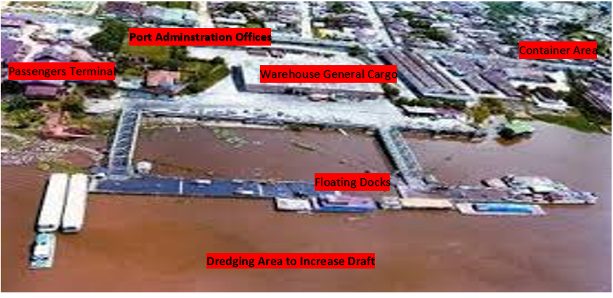
Port Picture
Description and Contacts of Key Companies
Euroandinos Port Terminals - Paita S.A. (TPE) is a company incorporated in Peru, whose corporate purpose is exclusively the administration, operation and exploitation of the Paita Port Terminal in accordance with the terms and conditions established in the Concession Contract signed with the Peruvian State, on September 9 2009, starting its operations as a concessionaire on October 8 of the same year.
The companies that make up the company are: Tertir Terminais (Yilport) and DP World Logistics (DP World). These companies are part of two large business groups with extensive experience and presence in the port sector at an international level.
For more information on port contacts, please see the following link: 4.4 Port and Waterways Companies Contact List.
Port Performance
Since the start of the concession in 2019, TPE Paita has registered a sustained annual growth of 9%, reaching more than 297,000 TEUS at the end of 2019. During 2019, Dredging works have been carried out at -14 meters in the access channel and maneuvering dock, which will allow the entry of ships of greater capacity to the terminal. Likewise, 03 forklifts have been acquired that will allow the best handling of cargo within the terminal.
The operations are mainly export-oriented. In 2019, of the 66% of export cargo, 93% was moved through containers. Peruvian agro-exports would reach US $ 8,500 million this year, which would represent an increase of 13.3% compared to the US $ 7,500 million registered in 2019, Piura remains the seventh exporting region of the country The main exports are hydrobiological and agro-industrial products.
Among the hydrobiological products we have squid, fish meal, frozen fish, fish oil and prawns, and among the agro-industrial products, bananas, grapes, mango, coffee, avocados, blueberries and peppers stand out. The main imports are solid bulk products, among which are fertilizers (ammonium sulfate, urea, potassium chloride, diammonium phosphate, etc.), grains (corn, wheat and soybean cake) and minerals (slag).
|
Seasonal Constraints |
||
|---|---|---|
|
Occurs |
Time Frame |
|
|
Rainy Season |
No |
|
|
Major Import Campaigns |
No |
|
|
Other Comments |
The monthly frequency of the total number of ships, in 2020 the greater quantity of ships during the month of February when reaching 62 units; while June was the month with the least movement of ships (28). It is believed that it was the effect of the global pandemic. |
|
|
Handling Figures for 2020 |
|
|---|---|
|
Vessel Calls |
554 |
|
Container Traffic (TEUs) |
344 |
|
Handling Figures Bulk and Break Bulk for 2020 |
|
|---|---|
|
Bulk (MT) |
2044 |
|
Break bulk (MT) |
756 |
Discharge Rates and Terminal Handling Charges
Euroandinos Port Terminals has the following tariff for the general user public, the description and scope of the services included in the tariff in the annex to the Regulation of Tariffs and Prices of TPE Paita is available in the following link.
Tarifario TPE - Version 16 (puertopaita.com)
https://puertopaita.com/wp-content/uploads/public/Tarifario_TPE-Version_17.pdf
Berthing Specifications
|
Type of Berth |
Quantity |
Length |
Maximum Draft |
Comments |
|---|---|---|---|---|
|
Conventional Berth |
1 |
365 m |
10 m |
Max Beam 32m, Max DWT Allowed 30,000, with 04 moorings. |
|
Container Berth |
1 |
300 m |
13.5 m |
Max Beam 32m, Max DWT Allowed 55,000, Min. Ship Gera Outreach 12m, Min. Parallel Body Length 75m |
|
Silo Berth |
N/A |
|
||
|
Berthing Tugs |
N/A |
|
||
|
Water Barges |
N/A |
|
The berths that the Paita Port Terminal
has, one of them the conventional one was already built and came
with the concession. The container berth is relatively new and is
part of the investment commitment in the port concession.
General Cargo Handling Berths
|
Cargo Type |
Berth Identification |
|---|---|
|
Imports - Bagged Cargo |
957 MT Container (Conventional Berth) |
|
Exports - Bagged Cargo |
1,834 MT Container (Container Berth) |
|
Imports and Exports - RoRo |
112 531 MT General Cargo (Conventional Berth) |
|
Other Imports |
637,148 MT Grain and Bulk Handling (Conventional Berth) |
Port Handling Equipment
All the equipment for handling the loading and unloading of the ships are from Terminales Portuarios Euroandinos - Paita S.A (TPE) is part of the concession of the port with the Peruvian state, there are no contractor companies that provide or rent equipment within the port terminal.
|
Equipment |
Available |
Total Quantity and Capacity Available |
Comments on Current Condition and Actual Usage |
|---|---|---|---|
|
Dockside Crane |
Yes |
4 RTG Cranes 45 MT |
Good Condition |
|
Container Gantries |
Yes |
2 STS Super Post Panamax Cranes 65 MT |
Good Condition |
|
Mobile Cranes |
Yes |
2 Mobile Harbour Cranes 101 MT |
Good Condition |
|
Reachstacker |
Yes |
3 Reach Stacker 45 MT |
Good Condition |
|
RoRo Tugmaster (with Trailer) |
Yes |
12 Terminal Trucks 55 MT |
Good Condition |
|
Grain Elevator with Bagging Machines |
No |
||
|
Transtainer |
Yes |
12 Chassis for Containers |
Good Condition |
|
Forklifts |
Yes |
3 Forklift 2, 3, 4 MT |
Good Condition |
Container Facilities
Most companies use bonded customs warehouses to store their cargo in containers, that is, they collect the containers from the port and take them to these warehouses and there the entire import or export process is carried out.
|
Facilities |
20 ft |
40 ft |
|---|---|---|
|
Container Facilities Available |
Yes |
Yes |
|
Container Freight Station (CFS) |
Yes |
Yes |
|
Refrigerated Container Stations |
Yes |
Yes |
|
Other Capacity Details |
||
|
Daily Take Off Capacity |
1200 |
1200 |
|
Number of Reefer Stations |
1980 |
1980 |
|
Emergency Take-off Capacity |
Yes |
Yes |
|
Off take Capacity of Gang Shift |
600 |
600 |
Customs Guidance
The SUNAT Customs offices are at the entrance to the Port of Paita (before the descent to the town), it offers all services and procedures. The hours of attention are according to office hours. In addition, as in all SUNAT offices, all imports are worked through systems (on line) of the customs itself.
For more information on customs in Peru, please see the following link: 1.3 Customs Information.
Terminal Information
Multipurpose Terminal
Standard services are those services that due to their operational characteristics are essential to complete the freight transport logistics chain. These are regulated by a ceiling rate, in such a way that the concessionaire can charge a maximum of the rate determined by the regulator. It should be noted that standard services are provided by the concessionaire on a mandatory basis to any user who requests it, necessarily complying with the Service and Productivity Levels. Standard services can be classified according to their scope, whether they are services provided based on the ship or based on the cargo:
Depending on the Vessel:
- Includes the use of the dock, mooring and unmooring. These services are necessary for a ship to be able to dock at the terminal and subsequently carry out loading and / or unloading of merchandise.
- The ship is charged for the hours it remains docked
- Charging unit: length meter-hour
- Start time: long ship the first spy in docking operation
- End time: long ship the last spy in undocking operation
- Includes mooring and unmooring service
Depending on the Cargo:
- In the case of shipment, the service ranges from the time the cargo enters the TPP until the ship in which it is embarked is unmoored to set sail. In the case of unloading, it ranges from the mooring of the ship to the removal of the cargo by the user.
- Collection unit for containerized cargo: per container
- Non-containerized shit collection unit: per ton
- Traction service: between the side of the ship and the storage area
- Weighing service
- Storage: 48 hours freely available to the user.
- In the case of transhipments, the rate for the standard service based on the load is charged only once from unloading to boarding the other ship, including the 48-day stay free of payment.
Grain and Bulk Handling
Regarding the loading and unloading of bulk and liquids, in both docks there are connection sleeves for the shipment of Bulk and Liquids. Below is the table with the discharge capacities of each of the types of cargo.
Dock 1-A is used for container ships, general cargo ships can operate in this dock, but container ships have priority over another ship. It recently has a connection sleeve for Bulk Ethanol Shipment.
Dock 1-B is a multipurpose dock / container cargo and bulk can be unloaded at this dock. Bulk unloading operations are always done considering the terminal ship cranes and grabs.
Main Storage Terminal
The Euroandinos Port Terminal has a total area of 142,000 square meters for cargo storage (Containers, Refrigerated and General), with the largest movement in containers.
|
Storage Type |
Number of Storage Facilities |
Area (m2) |
|---|---|---|
|
Bagged Cargo |
Area 3 |
4,500 |
|
Refrigerated Cargo |
Area 1 |
17,500 |
|
General Cargo |
Area 2 |
120,000 |
Stevedoring
The stowage activities at the Paita Port Terminal (TPE) are provided by the same port, the loading and unloading of ships are carried out by the same port personnel. It must be taken into account that they are mono concessions granted by the state on the operations of the port. The only services that are provided by third parties are pilotage and towing.
Hinterland Information
Most companies use bonded customs warehouses to store their cargo in containers, the cargo arrives at the port and the importer or cargo owner indicates where they will carry out their customs clearance or exploration procedures for the containers. The cargo leaves the port and they are taken to these warehouses and there the entire import or export process is carried out.
These consolidated warehouses belong to other companies that have nothing to do with the port concession. The port only loads or unloads the ships and delivers the containers to these shipping agencies, which are the ones that move the containers to these bonded warehouses of customs.
Port Security
Port security has a security services company and also a national police office, the port has a video surveillance system and maintains 24-hour security. In addition, it has the support of the National Police that, outside of the internal and external control of the port, does intelligence work to prevent smuggling and trafficking in narcotics or controlled substances.
|
Security |
|
|---|---|
|
ISPS Compliant |
Yes |
|
Current ISPS Level |
Level 2 |
|
Police Boats |
No |
|
Fire Engines |
No |
2.1.4 Peru Port of Terminal Portuario de Iquitos
Port Overview
The Iquitos Port Terminal is a major port that serves the City of Iquitos and is administered by the National Ports Company (ENAPU). It has as a natural entrance space to the Port of Iquitos that is benefited with an economic activity throughout the year. In the city, it is located in Villa de Punchana. The areas of influence are made up of the peoples of the Peruvian Amazon, as well as the border areas of the Republics of Brazil and Colombia.
The terminal is made up of two general floating type direct docking piers. It has 11 berths for smaller boats, bow berths and for larger boats depending on the length of the ship. The terminal was remodeled in 2015 and began its services in 2017, in parallel with its opening, the operations of the Amazonas I ferry began, which will travel from the city to Santa Rosa de Yavari on the Three Borders (Colombia, Brazil and Peru).
Other current problems are that they are finishing the dredging of the navigation channel of the Amazon, Marañon, Huallaga and Ucayali rivers so that larger ships can enter, at the moment we only work passenger and cargo movement from the ports of Pucallpa and Yurimaguas. The service to the border is only for passengers and the passenger terminal has recently been inaugurated in the Port of Iquitos.
Key port information can also be found at: http://www.maritime-database.com
|
Port Location and Contact |
|
|---|---|
|
Country |
Peru |
|
Province or District |
Maynas - Loreto |
|
Nearest Town or City with Distance from Port |
Iquitos (1.5 km) |
|
Port's Complete Name |
Terminal Portuario de Iquitos |
|
Latitude |
-3.728513 |
|
Longitude |
-73.239487 |
|
Managing Company or Port Authority |
Empresa Nacional De Puertos (ENAPU) |
|
Management Contact Person |
Gerencia Terminal Portuario Tel.: +5165 – 251955 |
|
Nearest Airport and Airlines with Frequent International Arrivals/Departures |
Aeropuerto Internacional Francisco Secada Vigneta Iquitos - Loreto LATAM, Viva Airlines, Sky Airlines |
Port Picture
Description and Contacts of Key Companies
The control and administration of the Port of Iquitos is on the part of the National Ports Company (ENAPU), they manage all port operations, they also coordinate with the Port Authority (Peruvian Navy), the departure and entry of ships to the port and also with the Coast Guard service in case of having any kind of problems with a boat. ENAPU's contact information in Iquitos is:
Terminal Portuario de Iquitos – ENAPU
Avenida La Marina No. 1383
Villa Punchana – Iquitos
Tel. +5165252275
Email. tpiquitos@enapu.com.pe
Web. https://www.enapu.com.pe/enapu/puertos_pt/terminal-de-iquitos/
Oficial de Proteccion Titular – Terminal Portuario de Iquitos
Nombre: Jimmy Gonzalo Allison Vásquez
Cargo: Técnico Administrativo – Seguridad
Cel.: +51 982565613
Tel.: +5165 251955
Email.: jvasquez@enapu.com.pe
For more information on port contacts, please see the following link: 4.4 Port and Waterways Companies Contact List.
Port Performance
Only passengers and national cargo move through the Port of Iquitos, as this type of vessels has little draft. The draft in the pontoon area is 6 meters, unfortunately they are waiting for them to finish dredging the navigation channel to enter to dredge the channel towards the port and the terminal area.
The port does not have much boat traffic at the moment, due to the high costs for warping ships, the owners of the passenger boats use other makeshift ports and do not pay any type of costs to dock their ships. What they were doing for large vessels, they carried barges with a portable crane and carried out the loading and unloading maneuvers in the same Amazon River, which has the greatest draft. The burden of humanitarian aid is by law a priority and there is always a willingness to help and support in this regard.
|
Seasonal Constraints |
||
|---|---|---|
|
Occurs |
Time Frame |
|
|
Rainy Season |
Yes |
The growing season between the months of March to May and the season of emptying between the months of August to October. |
|
Major Import Campaigns |
No |
|
|
Other Comments |
Because they are meandering rivers, it is necessary to be informed of the changes in the navigation channel and also of the palisades that occur when there are many winds. |
|
|
Handling Figures for 2019 - 2020 |
|
|---|---|
|
Vessel Calls |
2,910 |
|
Container Traffic (TEUs) |
0 |
|
Handling Figures Bulk and Break Bulk for 2019 - 2020 |
|
|---|---|
|
Bulk (MT) |
107,241 |
|
Break bulk (MT) |
107,219 |
Discharge Rates and Terminal Handling Charges
Organismo Supervisor de la Inversión en Infraestructura de Transporte de Uso Público (OSITRAN) - https://www.ositran.gob.pe/puertos/enapu/
|
Tarifas Trafico de Cabotaje |
||||
|---|---|---|---|---|
|
Terminal Portuario de Iquitos |
||||
|
Vigentes del 01/07/2021 al 31/12/2021 |
||||
|
Concepto |
Soles |
I.G.V. |
Total |
|
|
Servicios Regulados |
|
|
|
|
|
Art. 201 |
Servicio de Amarre y Desamarre de Naves |
|
|
|
|
|
Por cada Operación Terminal Portuario de Iquitos |
64.82 |
11.87 |
76.49 |
|
Art. 202 |
Uso de Amarradero |
|
|
|
|
|
1. Naves de Alto Bordo Por Metro de Eslora - Hora |
0.27 |
0.05 |
0.32 |
|
|
2. Naves Menores de hasta 80 metros de Eslora - Dia |
129.64 |
23.33 |
152.97 |
|
|
3. Barcazas, Chatas y similares - Dia |
12.96 |
2.33 |
15.30 |
|
Art. 203 |
Uso de Muelle Por Tonelada de Peso |
|
|
|
|
|
Carga Fraccionada |
4.13 |
0.74 |
4.87 |
|
|
Carga Rodante |
23.02 |
4.14 |
27.16 |
|
|
Carga Solida a Granel |
3.29 |
0.59 |
3.88 |
|
|
Carga Liquida a Granel |
1.64 |
0.30 |
1.94 |
|
|
Por Contenedor |
|
|
|
|
|
Contenedor con carga de 20 pies |
98.66 |
17.76 |
116.42 |
|
|
contenedor vacío de 20 pies |
21.38 |
3.85 |
25.22 |
|
|
contenedor con carga de 40 pies |
147.99 |
26.64 |
174.63 |
|
|
contenedor vacío de 40 pies |
34.53 |
6.22 |
40.75 |
|
Servicios No Regulados |
|
|
|
|
|
Art. 206 |
Servicio de Transferencia Por Tonelada Peso |
|
|
|
|
|
Carga Fraccionada |
0.84 |
0.15 |
0.99 |
|
|
Carga Solida a Granel |
0.84 |
0.15 |
0.99 |
|
|
Carga Rodante |
1.64 |
0.30 |
1.94 |
|
|
Por Contenedor con Carga |
|
|
|
|
|
Contenedores de 20 y 40 pies |
12.35 |
2.22 |
14.58 |
|
|
Por Contenedor Vacío |
|
|
|
|
|
Contenedores de 20 y 40 pies |
8.22 |
1.48 |
9.70 |
|
Art. 207 |
Servicio de Manipuleo |
|
|
|
|
|
Por Tonelada de Peso |
|
|
|
|
|
Carga Fraccionada |
0.84 |
0.15 |
0.99 |
|
|
Carga Solida a Granel |
0.84 |
0.15 |
0.99 |
|
|
Carga Rodante |
1.64 |
0.30 |
1.94 |
|
|
Por Contenedor con Carga |
|
|
|
|
|
Contenedores de 20 y 40 pies |
12.35 |
2.22 |
14.58 |
|
|
Por Contenedor Vacío |
|
|
|
|
|
Contenedores de 20 y 40 pies |
12.05 |
2.17 |
14.21 |
|
Art. 208 |
Almacenamiento de Carga Por Tonelada de Peso / Dia |
|
|
|
|
|
Carga Fraccionada |
|
|
|
|
|
* Primer Periodo |
0.65 |
0.12 |
0.77 |
|
|
* Segundo Periodo |
0.99 |
0.18 |
1.17 |
|
|
* Tercer Periodo |
1.30 |
0.23 |
1.53 |
|
|
Carga Rodante |
|
|
|
|
|
* Primer Periodo |
6.58 |
1.18 |
7.76 |
|
|
* Segundo Periodo |
9.87 |
1.78 |
11.64 |
|
|
* Tercer Periodo |
13.15 |
2.37 |
15.52 |
|
|
Carga Solida a Granel |
|
|
|
|
|
* Primer Periodo |
0.08 |
0.01 |
0.09 |
|
|
* Segundo Periodo |
0.11 |
0.02 |
0.14 |
|
|
* Tercer Periodo |
0.15 |
0.03 |
0.18 |
|
|
Por T.E.U. / Dia |
|
|
|
|
|
Contenedores con Carga |
|
|
|
|
|
* Primer Periodo |
8.22 |
1.48 |
9.70 |
|
|
* Segundo Periodo |
12.35 |
2.22 |
14.58 |
|
|
* Tercer Periodo |
16.44 |
2.96 |
19.40 |
|
|
Contenedores Vacíos |
|
|
|
|
|
* Primer Periodo |
4.13 |
0.74 |
4.87 |
|
|
* Segundo Periodo |
5.77 |
1.04 |
6.81 |
|
|
* Tercer Periodo |
8.22 |
1.48 |
9.70 |
|
Art. 209 |
Uso de Equipos, Embarcaciones y Material de Trabajo Por Hora |
|||
|
|
Equipos de Manipuleo y Tracción |
|||
|
|
Cargador Frontal |
152.96 |
27.53 |
180.50 |
|
|
Grúa - Hasta 20 Toneladas |
191.21 |
34.42 |
225.62 |
|
|
Grúa - Mas de 20 Toneladas |
305.93 |
55.07 |
361.00 |
|
|
Montacargas - Hasta 7,000 Libras |
95.60 |
17.21 |
112.81 |
|
|
Montacargas - Hasta 44,093 Libras (20 TM) |
114.72 |
20.65 |
135.37 |
|
|
Montacargas - Mas de 44,093 Libras (Mas de 20 TM) |
191.21 |
34.42 |
225.62 |
|
|
Portacontenedor Lleno |
305.93 |
55.07 |
361.00 |
|
|
Portacontenedor Vacío |
192.21 |
34.42 |
225.62 |
|
|
Tractor |
95.60 |
17.21 |
112.81 |
|
|
Camión con Plataforma |
152.96 |
27.53 |
180.50 |
|
|
Barredora (3 Horas Mínimo Facturable) |
114.72 |
20.65 |
135.37 |
|
|
Motobomba o Electrobomba |
76.48 |
13.77 |
90.25 |
|
|
Autobomba |
114.72 |
20.65 |
135.37 |
|
|
Vagoneta - Hasta 2 Toneladas |
3.82 |
0.69 |
4.51 |
|
|
Vagoneta - Mas de 2 Toneladas |
19.12 |
3.44 |
22.56 |
|
|
Otros Equipos No Especificados |
76.48 |
13.77 |
90.25 |
|
|
Equipo de Pesaje |
|
|
|
|
|
Balanza - Por Pesada |
22.94 |
4.13 |
27.07 |
|
|
Embarcaciones |
|
|
|
|
|
Lancha |
114.72 |
20.65 |
135.37 |
|
|
Material de Trabajo - Por Hora |
15.30 |
2.75 |
18.05 |
|
Art. 210 |
Ocupación de Muelles o Áreas - Por M2 / Dia |
|
|
|
|
|
a. Ocupación de Muelles |
|
|
|
|
|
Por m2/día |
1.15 |
0.21 |
1.35 |
|
|
b. Ocupación de Areas |
|
|
|
|
|
1. Carga Fraccionada o Granel |
|
|
|
|
|
Por m2/día |
1.15 |
0.21 |
1.35 |
|
|
2. Carga Rodante |
|
|
|
|
|
Por unidad/día |
|
|
|
|
|
- Automóviles y Camionetas |
9.56 |
1.72 |
11.28 |
|
|
- Ómnibus y Camiones |
42.07 |
7.57 |
49.64 |
|
|
- Equipos Pesados y Otros |
57.36 |
10.33 |
67.69 |
|
Art. 213 |
Consolidación o Desconsolidación de Contenedores Por Cada Servicio de Llenado o Vaciado |
|||
|
|
Contenedor 20 Pies |
229.45 |
41.30 |
270.75 |
|
|
Contenedor 40 Pies |
344.17 |
61.95 |
406.12 |
|
Art. 214 |
Desglose Conocimiento de Embarque |
|
|
|
|
|
Por Desglose |
76.48 |
13.77 |
90.25 |
|
Art. 217 |
Pernocte de Camiones |
|
|
|
|
|
Por Cada Vehículo |
76.48 |
13.77 |
90.25 |
|
Art. 218 |
Servicio a Pasajeros |
|
|
|
|
|
Por Pasajero - Terminal Portuario de Iquitos |
16.25 |
2.93 |
19.18 |
|
Art. 221 |
Barrido Contenedor Vacío |
|
|
|
|
|
Por Contenedor de 20 o 40 Pies |
26.77 |
4.82 |
31.59 |
Berthing Specifications
|
Type of Berth |
Quantity |
Length |
Maximum Draft |
Comments |
|---|---|---|---|---|
|
Conventional Berth |
1 | 114 m | 6 m |
Floating Type Dock, 3 pontoons (114 m x 15.36m x 1.80m) |
|
Container Berth |
1 | 72 m | 8 m |
Floating type dock 2 pontoons (72m x 15.36m x 1.80m) |
|
Silo Berth |
N/A |
|
||
|
Berthing Tugs |
N/A |
|
||
|
Water Barges |
N/A |
|
General Cargo Handling Berths
|
Cargo Type |
Berth Identification |
|---|---|
|
Imports - Bagged Cargo |
None |
|
Exports - Bagged Cargo |
None |
|
Imports and Exports - RoRo |
None |
|
Other Imports |
Oil and gas materials and supplies |
Port Handling Equipment
The Iquitos Port Terminal has not had much movement in recent years in reference to import and export cargo by river, this is due to the withdrawal of the service of the Amazon Shipping company that left the international route to from Iquitos, Manaus (Brazil), Miami (Florida), Houston (Texas). Importing mostly cargo for the oil industry. They have mostly been loading and unloading barges with varied cargo with food and basic necessities from Pucallpa or Yurimaguas. Normally cargo is loose and stevedores are used to load and unload these vessels.
|
Equipment |
Available |
Total Quantity and Capacity Available |
Comments on Current Condition and Actual Usage |
|---|---|---|---|
|
Dockside Crane |
Yes |
25 tons | Good condition |
|
Container Gantries |
No |
N/A | |
|
Mobile Cranes |
Yes |
20 tons | Good condition |
|
Reachstacker |
No |
N/A | |
|
RoRo Tugmaster (w/ Trailer) |
Yes |
30 tons | Good condition |
|
Grain Elevator w/ Bagging Machines |
No |
N/A | |
|
Transtainer |
No |
N/A | |
|
Forklifts |
Yes |
3.5 tons and 2.5 tons | Good condition |
Container Facilities
The container area of the Iquitos Port Terminal is a free zone with a cement floor, security and they were repairing a perimeter fence to give it greater security. Zone 7 is the designated area for containers, it has an area of 9,450 square meters. What happens is that almost no containerized cargo is moving at this time. They are carrying out the dredging works of the navigation channel in the Amazonas, Huallaga, Marañon and Ucayali Rivers so that larger vessels can move import and export cargo.
|
Facilities |
20 ft |
40 ft |
|---|---|---|
|
Container Facilities Available |
Yes |
Yes |
|
Container Freight Station (CFS) |
Yes | Yes |
|
Refrigerated Container Stations |
Yes | Yes |
|
Other Capacity Details |
||
|
Daily Take Off Capacity |
40 | 20 |
|
Number of Reefer Stations |
2 | 2 |
|
Emergency Take-off Capacity |
Yes |
Yes |
|
Off take Capacity of
Gang Shift |
20 | 10 |
Customs Guidance
SUNAT Customs, has an office within the facilities of the Iquitos Port Terminal, the staff has experience in handling cargo and equipment for oil exploration and exploitation, on imports in general, imports have really decreased almost to zero, and product exports. Also because the oil industry is almost paralyzed and ships with cargo for these companies do not come. Until a few years ago there was a traffic of every 2 or 3 months a ship with cargo in general, in addition to oil equipment and materials.
For more information on customs in Peru, please see the following link: 1.3 Customs Information.
Terminal Information
Multipurpose Terminal
A passenger terminal has just been inaugurated, with all its amenities and services for the ferry boats of the company Transtur S.A. that provides service between the city of Iquitos to the border with Brazil and Colombia (Santa Rosa Island). The rest of the port terminal is under maintenance and the dredging of the navigation channel was also to be carried out so that larger capacity ships can enter.
Grain and Bulk Handling
At the moment, no import or export of grains is handled through the Iquitos Port Terminal, the flour or grains that are consumed by the population of Iquitos comes from the City of Lima via Pucallpa or Yurimaguas. This cargo comes in barges called chatas and they use a tug to push a convoy of these vessels. Once the merchandise arrives at the port it goes immediately to the warehouses of the food distributors.
Main Storage Terminal
The Iquitos Port Terminal has 5 storage areas giving a total of 26,880 square meters, the area used for the storage of various cargo including dry and non-perishable food is Warehouse No.7, which has an area of 4,086 meters squares. According to what was expressed by the staff of the port terminal, most of the cargo that comes from Pucallpa and Yurimaguas arrives at the port terminal and immediately leaves for the wholesalers' warehouses in the City of Iquitos. Warehouses are generally used for cargo of greater volume or size, since the provisions and food are immediately withdrawn from the port.
|
Storage Type |
Number of Storage Facilities |
Area (m2) |
|---|---|---|
|
Bagged Cargo |
Warehouse no. 4 | 3,285 m2 |
|
Refrigerated Cargo |
Warehouse no. 6 | 1,560 m2 |
|
General Cargo |
Warehouses no. 1 and 7 | 12,586 m2 |
Stevedoring
Stowage is provided by the same port and there are also companies that offer this service within the same port. The major fluvial movement is done in barges carrying loose cargo, using stevedores and forklifts as support equipment.
Hinterland Information
The transport companies that offer the cargo and passenger transport service, offer the cargo service and they are in charge of taking the cargo to the port, as well as the loading and unloading of the vessels. But this is only for the national cargo from Pucallpa or Yurimaguas. Import cargo for the moment is not entering Peru through this port terminal. There are the contacts of the companies that provide cargo and passenger transport services.
Port Security
The Port Terminal has contracted a private security service, this service is responsible for providing security in all facilities, as well as for entering them. Any person entering the Iquitos Port Terminal must carry their photo check, issued by the Identification Office. Security agents are authorized to review and verify the photo check and the identification I.D. of the people who enter the Port Terminal. When the Security agents detect a false identity document or photo check, they must intervene with the people involved and make them available to the National Police Station for the clarification of the case.
The Control Center is the body responsible for monitoring people who enter the facilities of the Port Terminal, through its Closed-Circuit Television (CCTV), when any abnormal or suspicious situation is detected, it must notify the patrol for the corresponding intervention. All persons who enter the facilities of the Iquitos Port Terminal, must comply with and abide by the internal regulations and provisions of ENAPU S.A. Security agents will not allow the entry of packages, bags, backpacks or others, to the Operational Zone, for which they must have the written authorization of the Security Headquarters.
|
Security |
|
|---|---|
|
ISPS Compliant |
Yes |
|
Current ISPS
Level |
Level 1 |
|
Police Boats |
No |
|
Fire Engines |
No |
Terminal Portuario de Iquitos – ENAPU
Avenida La Marina No. 1383
Villa Punchana – Iquitos
Tel. +5165252275
Email. tpiquitos@enapu.com.pe
Web. https://www.enapu.com.pe/enapu/puertos_pt/terminal-de-iquitos/
Oficial de Proteccion Titular – Terminal Portuario de Iquitos
Nombre: Jimmy Gonzalo Allison Vásquez
Cargo: Técnico Administrativo – Seguridad
Cel.: +51 982565613
Tel.: +5165 251955
Email.: jvasquez@enapu.com.pe
Servicios y Equipos Amazonicos S.A.
Av. La Marina 486
Iquitos – Perú
Tel. +5165 252503 / +5165 252499 / +5165 252501
Web. www.sea.com.pe
Transportes Jupiter S.R.L.
Av. La Marina No. 2067
Iquitos – Perú
Tel. +5165 600343
Email. operaciones@transjupiter.com
Web. www.transjupiter.com
Trans Pacifico S.A.C.
Jr. Bolívar No. 452, Callería
Pucallpa – Perú
Tel. +5161 578007
Email. informacion@transpacificosac.com
Corporación Turística Yurimaguas S.A.C.
Calle Elena Pardo # 114
Yurimaguas – Perú
Gerente General - Víctor Hugo Rodríguez
Tel. +5165 351270
Cel. +51 948621011
Mail. J1989_6@hotmail.com
Transtur S.A.
Calle Raimondi # 384
Iquitos – Perú
Gerente General - Alex Pinedo
Tel. +5165 221356
Cel. +51 965653095
Web. www.transtursa.com
2.1.5 Peru Port of Callao – Terminal Multiproposito Muelle Norte
Port Overview
On May 11, 2011, the Concession Agreement for the design, construction, financing, conservation and operation of the North Multipurpose Terminal of the Port of Callao was signed between the company APM Terminals Callao S.A. and the Ministry of Transport and Communications, with a validity of 30 years. The modality by which the Concession is delivered is called "DBFOT" (Design, Build, Finance, Operate and Transfer), which includes, in addition to the maritime and land area of the concession, the infrastructure and port equipment that it contains, so that it designs, build, finance, maintain, operate and exploit the terminal, having to transfer said infrastructure and equipment to the Peruvian State at the end of the Concession Contract.
The TNM project comprises four central docks, a north dock, a hydrocarbon dock and a grain dock, with their respective backing areas. This terminal is designed for handling of containerized cargo and general cargo (metals, grains, fertilizers, chemicals, among others). During the term of the concession, APMT must make a benchmark investment of USD 895.6 million dollars, distributed in five stages of the modernization project. On July 1, 2011, the Concessionaire began rendering services in the TNM, operating the existing infrastructure that was received as a result of the granting of the concession.
As a result of the measures applied both in Peru and in various parts of the world to combat the COVID-19 pandemic, various sectors of the economy suffered a series of impacts that, to a greater or lesser extent, also had effects on the demand for maritime transport infrastructure services. Thus, in the case of the TNM, during 2020 the terminal served a total of 1,502 ships, which translates into a reduction of 10.4% compared to 2019, and mobilized around 17.79 million tons of cargo and 854.9 thousand TEUs of containers, representing a contraction of 7.0% and 4.9%, respectively, with respect to what was mobilized in the year 2019.
Port website: www.apmterminalscallao.com.pe
Key port information may also be found at: http://www.maritime-database.com
|
Port Location and Contact |
|
|---|---|
|
Country |
Peru |
|
Province or District |
Callao |
|
Nearest Town or City with Distance from Port |
Lima (10 km) |
|
Port's Complete Name |
Terminal Multiproposito Muelle Norte - Callao |
|
Latitude |
12.046944 |
|
Longitude |
77.142778 |
|
Managing Company or Port Authority |
APM Terminals |
|
Management Contact Person |
APM Terminals Callao Av. Contralmirante Raygada No. 111 Callao Callao Perú Tel.: +51 1 200-8800 |
|
Nearest Airport and Airlines with Frequent International Arrivals/Departures |
Jorge Chavez International Airport LATAM, Viva Airlines, American Airlines, United Airlines, Delta Airlines, Avianca, Aerolineas Argentinas, Iberia, Lufthansa, Air France, KLM, Europa Air, Copa Airlines |
Port Picture
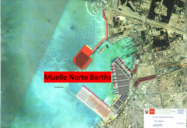
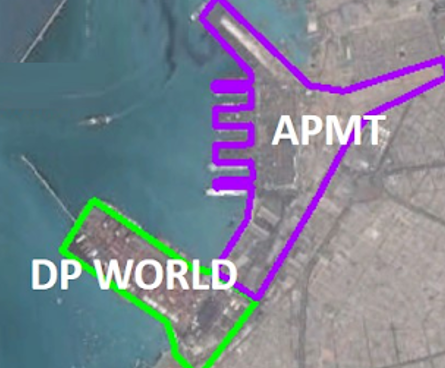
The two concessions of the Muelle del Callao (DP World and APM Terminals), are clearly detailed for illustration.
Description and Contacts of Key Companies
The Callao - Muelle Norte Multipurpose Port Terminal offers the following services:
Ship Services
They currently have more than 3,700 linear meters of berthing frontage distributed in 7 docks or 15 moorings, receiving mainly multipurpose ships, container ships, bulk vessels, tankers, etc. fishing boats, tourist cruises, among others.
Cargo Services
For the loading and / or unloading of containerized cargo, fractional cargo, rolling cargo, project cargo, bulk cargo, solid and liquid.
Containers: Container loading and unloading services for the shipping lines that visit the terminal, as well as the mobilization of transhipment cargo.
Rolling: Mooring, loading and unloading of various rolling cargo, from light vehicles to heavy machinery, self-propelled or on platforms or special trailers. Likewise, the port also operates as a hub, serving and temporarily storing transshipment cargo. Among the main shipping lines, we have Wallenius Willhelsem, NYK, MOL, K-Line, CSAV, Hoegh Autoiliner, Eukor, Glovis and CCNI. The port also carries out, among the main services, the storage and de-consolidation of cargo to consignees that require it.
Fractional: The port offers the services of use of mooring, loading and unloading of diverse fractional cargo, including special cargo or project cargo. The main merchandise mobilized are; cement in bags, iron and steel products such as coils, pipes, wire rod, plates, rods, even capital goods and various real estate such as yachts, machinery and industrial equipment, among others. In case the specifications of the fractional load match the parameters established for the project load, the specific surcharge (special service) in force must be considered.
Projects: As a multipurpose terminal the Port has mobilized a large part of the cargo generated for the execution of large public and private investment projects, receiving multiple formats of cargo required for the construction of the different projects and sectors of the country, such as infrastructure, mining, energy and oil, among others.
Bulk: The port offer the services of use of mooring, shipping and unloading of solid and liquid bulk. The liquid cargo can be unloaded and / or shipped directly from and from the tanker to the tanker ships using special equipment (lecterns and hoses) as well as it can be unloaded through the network of pipes present in the terminal which are They are interconnected with the main nearby specialized liquid terminals. In the case of clean bulk (cereals and grains) the Port also offer storage service in Silos. The main solid bulk cargoes are; grains and cereals, fertilizers, cement, limestone, phosphoric stone, lime, minerals, among others, which arrive in bulk carriers or bulk carriers. While the main liquid goods are; crude oil and petroleum derivatives, gasoline, biofuels, NGV, GLV, various chemicals, and edible oils, which are transported in tankers or tanker vessels.
Passenger Services
They provide the infrastructure required to carry out the embarkation and disembarkation of passengers arriving on tourist, academic, military, scientific and / or humanitarian or assistance cruises. The main tourist cruise lines that call at the terminal during each campaign (which generally runs from October to April) are Holland American Line, Royal Caribbean, Celebrity, Princess, Norwegian Cruise Line, Costa, Oceania, among others.
Temporary Deposit
A Temporary Warehouse is located within the port facilities. When carrying out operations with the APMTC Temporary Warehouse, loads may be assigned to the different regimes allowed by current regulations, such as the Import, Export, Transhipment and Reshipment Regime. This service is offered for the following types of Containerized Cargo, Project Cargo, Split Cargo and Rolling Cargo.
Complementary Services
Additional services to the stowage and / or unloading service for both the cargo and the ships provided within the port area, such as Storage outdoors, roofing and / or in silos, Consolidation and deconsolidation of FCL cargo and MAFI trailers, Project cargo custody, Water supply, Supply of containment barrier for liquid fuels, Disposal of solid and oily waste and Office rental, among others.
PRACTICE SERVICES COMPANIES
- ARGOS MARINE EIRL
- CORPORACION DE PRACTICOS S.A.
- MARITIME & SERVICES S.A.C.
- WABISABI SHIP SUPPLY AND SERVICES S.A.C.
- LOYOLA ALVAREZ, JAIME E.I.R.L.
- NAUTILIUS S.A.
- AGENCIAS UNIVERSALES PERU S.A.
- ALDEBARAN PILOTES S.A.C.
- AGENCIA MARITIMA KENRICK DEL PERU S.A.
- PILOTOS DEL SUR SOUTH PILOTS S.A.
- MANUEL IZQUIERDO ZELADA EIRL
- TRAMARSA FLOTA S.A.
TOWING SERVICES COMPANIES
- INVERSIONES MARITIMAS CPT PERU (INMARSA)
- PETROLERA TRANSOCEANICA S.A.
- IAN TAYLOR PERU S.A.C.
- EMPRESA MARITIMA DEL PERU S.A.
- TRAMARSA FLOTA S.A.
- SVITZER PERU S.A.
APM Terminals Callao
Av. Contralmirante Raygada No. 111 Callao
Callao Perú
Tel.: +51 1 200-8800
Port website: www.apmterminalscallao.com.pe
OSITRAN (Supervisory Body of Transport Infrastructure)
Calle Los Negocios No. 182, Piso 1, Surquillo
Lima – Perú
Tel: +511 500 9330
Ositran website: www.ositran.gob.pe
Autoridad Portuaria Nacional (APN)
Av. Santa Rosa No. 135, La Perla
Callao – Perú
Tel. +511 630 9600
APN website: www.apn.gob.pe
For more information on port contacts, please see the following link: 4.4 Port and Waterways Companies Contact List.
Port Performance
|
Seasonal Constraints |
||
|---|---|---|
|
Occurs |
Time Frame |
|
|
Rainy Season |
No |
|
|
Major Import Campaigns |
Yes |
From (November) to (January) |
|
Other Comments |
The bottlenecks are due to the traffic that exists in the port area, this is where the loading of access and / or departure from the port can be delayed. |
|
|
Handling Figures for 2020 |
|
|---|---|
|
Vessel Calls |
1,502 |
|
Container Traffic (TEUs) |
854,907 |
|
Handling Figures Bulk and Break Bulk for 2020 |
|
|---|---|
|
Bulk (MT) |
17,793,279 |
|
Break bulk (MT) |
1,915,801 |
Discharge Rates and Terminal Handling Charges
Rates include Standard and Special Services provided by the Terminal, referring to containerized cargo, general cargo and passenger cruise operations. For information on port rates and charges, please see the following link:
https://www.apmterminalscallao.com.pe/default.aspx?id=125&articulo=19
Berthing Specifications
|
Type of Berth |
Quantity |
Length (m) |
Maximum Draft (m) |
Comments |
|---|---|---|---|---|
|
Conventional Berth |
Muelle 1 Muelle 2 Muelle 3 Muelle 4 Muelle 11 |
182.80 182.80 182.80 182.80 280.00 |
10.00 10.00 10.00 10.00 15.50 |
Multipurpose Berth - 30 meters wide Multipurpose Berth – 82 meters wide Multipurpose Berth – 82 meters wide Multipurpose Berth – 30 meters wide Multipurpose Berth - |
|
Container Berth |
Muelle 5 Muelle 7 |
390.00 262.90 |
15.50 10.50 |
Containers & Tankers Tankers |
|
Silo Berth |
N/A |
|
||
|
Berthing Tugs |
N/A |
|
||
|
Water Barges |
N/A |
|
The characteristics of the port
infrastructure of APM Terminals Callao is composed of seven (7)
piers, which present the characteristics described in the table
above.
General Cargo Handling Berths
|
Cargo Type |
Berth Identification |
|---|---|
|
Imports - Bagged Cargo |
12,841,282 MT – Multipurpose Berth |
|
Exports - Bagged Cargo |
3,103,592 MT – Multipurpose Berth |
|
Imports and Exports - RoRo |
202,983 MT - Multipurpose Berth |
|
Other Imports |
Bulk Liquids 2,381,665 MT Bulk Solids 5,713,414 MT |
Port Handling Equipment
The Muelle Norte Port Terminal, in accordance with the Concession Contract with the Peruvian State, has its own equipment and machinery for the exclusive provision of each and every one of the services that can be provided within the port infrastructure.
|
Equipment |
Available |
Total Quantity and Capacity Available |
Comments on Current Condition and Actual Usage |
|---|---|---|---|
|
Dockside Crane |
No |
||
|
Container Gantries |
Yes |
4 Gantry Cranes STS Super Post – Panamax 2 Gantry Cranes STS - Panamax |
Good Condition Good Condition |
|
Mobile Cranes |
Yes |
4 MHC Post Panamax 12 Gantry Cranes RTG 4 Liebherr Cranes 550 |
Good Condition Good Condition Good Condition |
|
Reachstacker |
Yes |
7 Reach Stackers |
Good Condition |
|
RoRo Tugmaster (with Trailer) |
Yes |
20 Terminal Tractors |
Good Condition |
|
Grain Elevator with Bagging Machines |
No |
||
|
Transtainer |
Yes |
2 Empty Handlers |
Good Condition |
|
Forklifts |
Yes |
20 Forklifts |
Good Condition |
Container Facilities
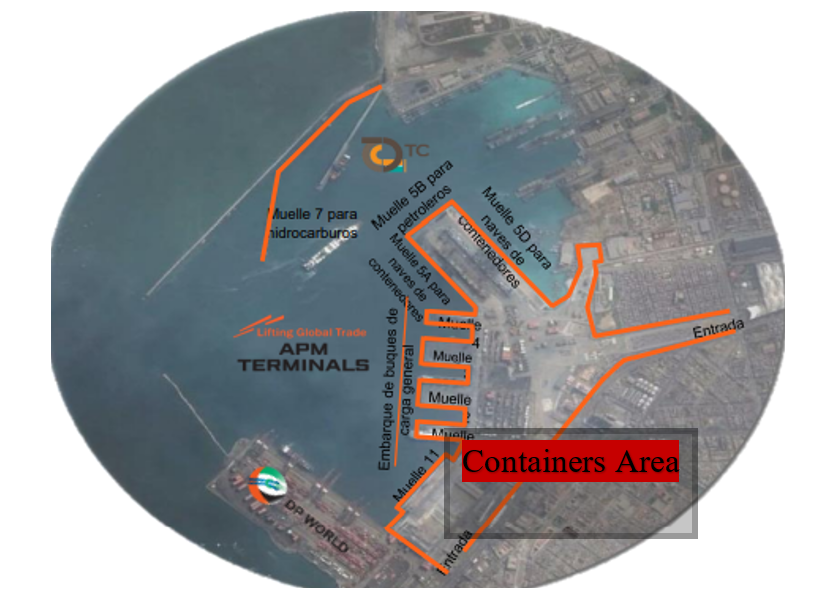
The area for storing containers in the Muelle Norte Port Terminal is 120,000 square meters.
|
Facilities |
20 ft |
40 ft |
|---|---|---|
|
Container Facilities Available |
Yes |
Yes |
|
Container Freight Station (CFS) |
Yes |
Yes |
|
Refrigerated Container Stations |
Yes |
Yes |
|
Other Capacity Details |
||
|
Daily Take Off Capacity |
90 |
90 |
|
Number of Reefer Stations |
4 Sub-Stations x 60 containers |
4 Sub-Stations x 60 containers |
|
Emergency Take-off Capacity |
120 |
120 |
|
Off take Capacity of Gang Shift |
30 |
30 |
Customs Guidance
Within the facilities of the Muelle Norte Port Terminal, there are the offices of the Callao Maritime Customs, which belong to SUNAT Aduanas. All kinds of customs operations that are required are carried out there.
For more information on customs in Peru, please see the following link: 1.3 Customs Information.
Terminal Information
Multipurpose Terminal
Regarding the behaviour of the volumes of cargo mobilized in the Multipurpose Port Terminal Muelle Norte, during 2020 there was a contraction of 7.0% compared to what was registered in 2019, going from 19.13 to 17.79 million tons, respectively. In this regard, it should be taken into account that said result has been influenced by the restriction measures of economic activities imposed in the framework of the fight against COVID-19, in particular during the first months of the entry into force of the State of National Emergency.
The volume of rolling cargo (Ro - Ro) mobilized by the TNM amounted to 203 thousand tons in 2020, which represented a significant reduction of 36.4% compared to that registered in 2019. In this regard, although this reduction was influenced by the restrictions in the framework of the COVID-19 pandemic, it should also be noted that the historical trend observed for this type of cargo had a decrease since 2014, registering an average annual decrease of 1.29% between 2014 and 2019.
Grain and Bulk Handling
During 2020, the volume of solid bulk cargo handled by the TNM amounted to 5.71 million tons, which represented a reduction of 4.95% compared to that registered in 2019. Also note that all of the Solid bulk cargo volumes mobilized during 2020 corresponded to imports.
In 2020, the volume of liquid bulk cargo handled by the TNM amounted to 2.38 million tons, which represented a reduction of 11.2% with respect to that registered in 2019. In this regard, although said reduction in Volumes were influenced by the restrictions presented in the framework of the pandemic worldwide, registering an average annual decrease of 4.52% in recent years.
Stevedoring
The Muelle Norte Port Terminal in accordance with the Concession Contract with the Peruvian State, the Concessionaire has the right to the execution and / or exclusive provision of each and every one of the services that may be provided within the port infrastructure, with the exception of pilotage and towing services, which are subject to the Ositrán REMA. Thus, under this scheme, the services that the Concessionaire can provide are classified into two types: Standard Services and Special Services.
Hinterland Information
The biggest movement is the entry and exit of containers to the bonded warehouses of customs, each shipping company works with different warehouses, these warehouses are in the same area of Callao but are outside the port facilities.
Port Security
|
Security |
|
|---|---|
|
ISPS Compliant |
Yes |
|
Current ISPS Level |
Level 2 |
|
Police Boats |
No |
|
Fire Engines |
No |
2.1.6 Peru Port of Yurimaguas
Port Overview
The Yurimaguas Port Terminal is under the administration of COPAM - CONCESIONARIA PUERTO AMAZONAS S.A. It is located in the town of Yurimaguas, district of the same name, Alto Amazonas province, Loreto department. It is located at an altitude that oscillates below 200 meters above sea level. The Yurimaguas Port Terminal is located as the point of modal exchange of products between the areas of the cities of Chiclayo and Piura and the Amazon region, specifically the city of Iquitos. Industrial products and food, among others, are transported from Chiclayo and Piura by road to the Yurimaguas Port Terminal, to be shipped and transported by river to Iquitos. Likewise, from Iquitos, products such as sawn wood, rubber, jute and imported goods leave for Yurimaguas, to later be transported by truck to Chiclayo and Piura.
The cargo moved is mainly cabotage, of the fractional type. The movement of goods registered in Yurimaguas will be carried out through the Yurimaguas Port Terminal. It does not include the liquid cargo corresponding to hydrocarbons that is mobilized at the PETROPERU pier. The concession of the New Yurimaguas Port Terminal - Nueva Reforma is co-financed in nature and for a term of 30 years.
COPAM - CONCESIONARIA PUERTO AMAZONAS S.A.
Av. Javier Prado Este 4135, Piso 4 - Santiago de Surco
Lima 15073, Perú
Tel: +511 5002670, Ext. 100 (Reception)
Ing. Carmen Benítez - General Manager
Mail. cbenitez@copam.com.pe
Web. www.copam.com.pe
Terminal Portuario de Yurimaguas
Vía de Evitamiento Km. 0.0 Caserío Santa Rosa
Rio Huallaga – Yurimaguas – Alto Amazonas – Loreto
Tel. +511 500 0450
Key port information can also be found at: http://www.maritime-database.com
|
Port Location and Contact |
|
|---|---|
|
Country |
Peru |
|
Province or District |
Yurimaguas - Loreto |
|
Nearest Town or City with Distance from Port |
Yurimaguas - Loreto (5.5 km) |
|
Port's Complete Name |
Terminal Portuario de Yurimaguas – Nueva Reforma |
|
Latitude |
-5.850803 |
|
Longitude |
-76.160310 |
|
Managing Company or Port Authority |
Consorcio Puerto Amazonas S.A. - COPAM |
|
Management Contact Person |
Ruben Del Águila, Commercial Manager Tel. +511 500 0450 |
|
Nearest Airport and Airlines with Frequent International Arrivals/Departures |
Aeropuerto Internacional Francisco Secada Vigneta Iquitos - Loreto LATAM, Viva Airlines, Sky Airlines |
Port Picture
Description and Contacts of Key Companies
The Consorcio Puerto del Amazonas is a Peruvian company that provides shipping, disembarkation, reception and dispatch services of diverse fractional cargo, including special cargo or project cargo. The main goods mobilized are: cement in bags, iron and steel products such as: coils, pipes, wire rod, plates, rods, wood, scrap packages, fragile cargo (glass, tiles), refrigerated cargo, machinery and industrial equipment, among others. In case the specifications of the fractional load match the parameters established for the project load, the specific surcharge (special service) in force must be considered.
For more information on port contacts, please see the following link: 4.4 Port and Waterways Companies Contact List.
Port Performance
In 2020, the quantity demanded for standard cargo services at the Yurimaguas Port Terminal (17,068 tons) was concentrated only in fractional goods (11,823 tons), containerized (4 596 tons) and bulk liquid (649 tons), which represented 69.3%, 26.9% and 3.8% of the total cargo handled, respectively. This result shows a reduction of 15.1% compared to 2019, where demand reached 20,114 tons.
During 2020, 413 ships were served at the Yurimaguas Port Terminal, which meant a 5.7% drop compared to the previous year, in which 438 ships were served. Referring to distribution of the type of vessels served, 82.1% were river boats, 8.2% river artifacts, 6.5% river pushers and 3.1% river boats.
|
Seasonal Constraints |
||
|---|---|---|
|
Occurs |
Time Frame |
|
|
Rainy Season |
Yes |
The growing season between the months of March to May and the season of emptying between the months of August to October. |
|
Major Import Campaigns |
No |
|
|
Other Comments |
Because they are meandering rivers, it is necessary to be informed of the changes in the navigation channel and also of the palisades that occur when there are many winds. |
|
|
Handling Figures for 2020 |
|
|---|---|
|
Vessel Calls |
413 |
|
Container Traffic (TEUs) |
551 |
|
Handling Figures Bulk and Break Bulk for 2020 |
|
|---|---|
|
Bulk (MT) |
17,717 |
|
Break bulk (MT) |
11,823 |
Discharge Rates and Terminal Handling Charges
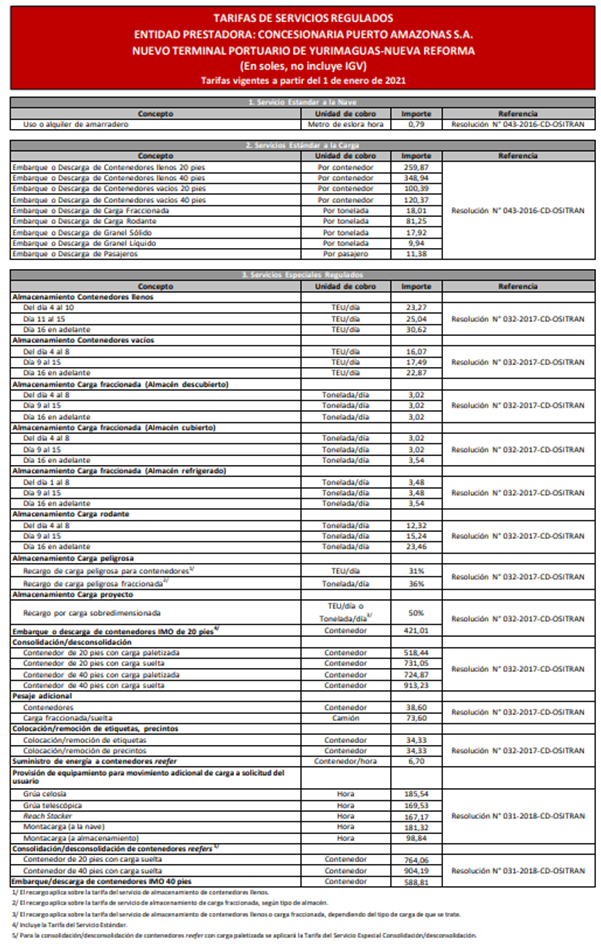
Berthing Specifications
|
Type of Berth |
Quantity |
Length (m) |
Maximum Draft (m) |
Comments |
|---|---|---|---|---|
|
Conventional Berth |
1 | 120 m | 10 m |
Dock with two moorings, plus a 10-meter berth for passengers floating and access for passengers. |
|
Container Berth |
N/A |
|
||
|
Silo Berth |
N/A |
|
||
|
Berthing Tugs |
N/A |
|
||
|
Water Barges |
N/A |
|
Complementary facilities: Construction of buildings for administrative and service areas. Two (2) Container Chassis, one (1) vessel for river works maintenance. Control booths for the facilities, scale for cargo vehicles, drinking water reservoir, water treatment tank, drinking water network and fire protection network, drainage network and primary sewage treatment plant, crown and side gutters, drainage channels, sub-drainage, electrical outlet in the container yards for refrigerated cargo, power house to house electrical generator equipment.
General Cargo Handling Berths
|
Cargo Type |
Berth Identification |
|---|---|
|
Imports - Bagged Cargo |
N/A |
|
Exports - Bagged Cargo |
N/A |
|
Imports and Exports - RoRo |
N/A |
|
Other Imports |
N/A |
Port Handling Equipment
All the cargo handling equipment in the port is new, in perfect condition, and they are still not very used due to the little traffic of ships that the port is using.
|
Equipment |
Available |
Total Quantity and Capacity Available |
Comments on Current Condition and Actual Usage |
|---|---|---|---|
|
Dockside Crane |
Yes |
1 (30 tons) | In good condition |
|
Container Gantries |
No |
||
|
Mobile Cranes |
Yes |
1 (30 tons) | In good condition |
|
Reachstacker |
Yes |
1 (45 tons) | In good condition |
|
RoRo Tugmaster (w/ Trailer) |
Yes |
2 (30 tons) | In good condition |
|
Grain Elevator w/ Bagging Machines |
No |
||
|
Transtainer |
Yes |
2 (30 tons) | In good condition |
|
Forklifts |
Yes |
5 (5 Tons) & 1 (10 Ton) | In good condition |
Container Facilities
In the Port of Yurimaguas (COPAM), it has electrical outlets in the container yards for refrigerated cargo, the container storage yard has an area of 10,000 m2, the area has lighting and the entire area is the platform or surface. it is concrete. The port has two units for the movement of containers, the entire surface up to the berth area is made of concrete, it is easy and fast to move the containers from the berth to the yard.
|
Facilities |
20 ft |
40 ft |
|---|---|---|
|
Container Facilities Available |
Yes |
Yes |
|
Container Freight Station (CFS) |
Yes | Yes |
|
Refrigerated Container Stations |
Yes | Yes |
|
Other Capacity Details |
||
|
Daily Take Off Capacity |
80 | 80 |
|
Number of Reefer Stations |
4 | 4 |
|
Emergency Take-off Capacity |
Yes |
Yes |
|
Off take Capacity of
Gang Shift |
40 | 40 |
Customs Guidance
The Yurimaguas Port Terminal has a SUNAT Customs office, but at present it does not have import cargo movement, only passengers in those boats or motorboats that travel to the city of Iquitos. They are waiting to finish the dredging works of the navigation channel of the Huallaga, Marañon, Ucayali and Amazonas rivers. So that ships of greater draft can enter.
For more information on customs in Peru, please see the following link: 1.3 Customs Information.
Terminal Information
Multipurpose Terminal
The facilities are available but due to the lack of cleaning and dredging of the navigation channel, vessels of greater depth and capacity cannot enter.
Grain and Bulk Handling
The loading and handling of cereals in the Yurimaguas Port Terminal is only done in loose cargo per bag or bulk, this cargo comes mostly from the coastal area via land and its final destination is the city of Iquitos.
Main Storage Terminal
The Yurimaguas Port Terminal has storage facilities of 6,692 square meters, of which 600 square meters are destined for refrigerated cargo. All the roads or sidewalks to the berth are made of cement, making the handling of the cargo very fast and easy.
|
Storage Type |
Number of Storage Facilities |
Area (m2) |
|---|---|---|
|
Bagged Cargo |
Same as general cargo area | |
|
Refrigerated Cargo |
1 | 600 m2 |
|
General Cargo |
1 | 6,092 m2 |
Stevedoring
The Port of Yurimaguas offers the services of loading and unloading the vessels according to the rates detailed below, it has the necessary personnel and equipment for the loading and unloading of ships. At the moment they only offer services to vessels transporting loose cargo.
Hinterland Information
Due to the location of the port that is far from the city, the port offers all the services and personnel necessary for the handling of loose cargo, in addition to the movement of containers.
Port Security
The port has a good security service, surveillance cameras, a perimeter fence with olympic mesh and good lighting at night in all areas of the port. In addition, there is a National Police post within the Port facilities.
|
Security |
|
|---|---|
|
ISPS Compliant |
Yes |
|
Current ISPS
Level |
Level 1 |
|
Police Boats |
No |
|
Fire Engines |
No |
COPAM - CONCESIONARIA PUERTO AMAZONAS S.A.
Av. Javier Prado Este 4135, Piso 4 - Santiago de Surco
Lima 15073, Perú
Tel. +511 5002670, Ext. 100 (Reception)
Ing. Carmen Benítez - General Manager
Mail. cbenitez@copam.com.pe
Web. www.copam.com.pe
Terminal Portuario de Yurimaguas
Vía de Evitamiento Km. 0.0 Caserío Santa Rosa
Rio Huallaga – Yurimaguas – Alto Amazonas – Loreto
Tel. +511 500 0450
Corporación Turística Yurimaguas S.A.C.
Calle Elena Pardo # 114
Yurimaguas – Perú
Gerente General - Víctor Hugo Rodríguez
Tel. +5165 351270
Cel. +51 948621011
Mail. J1989_6@hotmail.com
Trans Pacifico S.A.C.
Jr. Bolívar No. 452, Callería
Pucallpa – Perú
Tel. +5161 578007
Email. informacion@transpacificosac.com
2.1.8 Peru Port of Salaverry
Port Overview
The Port of Salaverry is located in Trujillo, La Libertad. The port is at a distance of approximately 14 kilometers from the center of the city of Trujillo and is very close to the Pan-American Highway (8 km). On May 31, 2018, the concession was awarded to Transportadora Salaverry (Grupo Romero) .5 The contract was approved by the state through a decree on July 12, 20186. In 2019, the port movement in the port of Salaverry was 1820 TEU, ranking 117th on the list of port activity in Latin America and the Caribbean.
Port website: www.sti.com.pe
Key port information may also be found at: http://www.maritime-database.com
|
Port Location and Contact |
|
|---|---|
|
Country |
PERU |
|
Province or District |
SALAVERRY - TRUJILLO |
|
Nearest Town or City with Distance from Port |
TRUJILLO DISTANCE 8.0 km |
|
Port's Complete Name |
TERMINAL PORTUARIO MULTIPROPOSITO SALAVERRY |
|
Latitude |
8°13’42” S |
|
Longitude |
78°58’ 50” W |
|
Managing Company or Port Authority |
CONSORCIO TRANSPORTADORA SALAVERRY S.A. |
|
Management Contact Person |
|
|
Nearest Airport and Airlines with Frequent International Arrivals/Departures |
AEROPUERTO INTERNACIONAL DE TRUJILLO CAP. CARLOS MARTINEZ DE PINILLOS LATAM, VIVA AIRLINES, SKY AIRLINES |
Port Picture
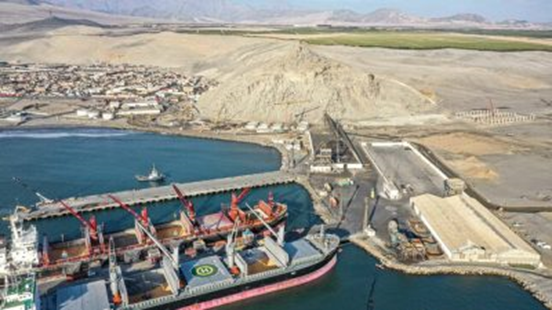
Description and Contacts of Key Companies
The Consorcio Transportadora Salaverry S.A. Made up of Tramarsa and Naviera Tramarsa, it was awarded the concession of the Salaverry Port Terminal on May 31, 2018, establishing Salaverry Terminal Internacional S.A. It is through this concessionaire that the modernization and operation of the Salaverry Port Terminal begins. The Tramarsa Group is a conglomerate of leading companies with more than 28 years of experience in the maritime and port operations market.
Salaverry Terminal Internacional STI
Calle Córdova S/N, Distrito Salaverry, Trujillo
La Libertad – Perú
Tel.+51 942864131
Web. www.sti.com.pe
For more information on port contacts, please see the following link: 4.4 Port and Waterways Companies Contact List.
Port Performance
In this regard, it is important to mention that, as a result of the measures applied both in Peru and in various parts of the world to combat the COVID-19 pandemic, various sectors of the economy suffered a series of impacts that, to a greater or lesser extent, to a lesser extent, they also had effects on the demand for maritime transport infrastructure services.
Thus, although in the Peruvian case, during the State of National Emergency the port terminals of the country did not present restrictions for the development of their operations, the effects on the traffic levels in the ports occur indirectly depending on the degree of reactivation of both the national and foreign economy.
|
Seasonal Constraints |
||
|---|---|---|
|
Occurs |
Time Frame |
|
|
Rainy Season |
No |
|
|
Major Import Campaigns |
No |
|
|
Other Comments |
The largest movement of the dock is for the import of grains and the export of mineral concentrates, it does not have many seasonal difficulties. |
|
|
Handling Figures for 2020 |
|
|---|---|
|
Vessel Calls |
178 |
|
Container Traffic (TEUs) |
0 |
|
Handling Figures Bulk and Break Bulk for 2020 |
|
|---|---|
|
Bulk (MT) |
2,539,967 MT |
|
Break bulk (MT) |
50,915 MT |
Discharge Rates and Terminal Handling Charges
The rates in force from the beginning of the operation of the Concession are:
STANDARD SERVICES:
▪ Ship Services:
- Berth use per meter-length per hour: USD 1.25
- Ship access service *: USD 1.75
▪ Cargo services **:
International shipping or unloading service
- Fractional cargo (per MT): USD 13.50
- Bulk cereal load (per MT): USD 9.10
- Bulk ore cargo (per MT): USD 13.50
- Other dry cargoes in bulk (per MT): USD 9.10
- Liquid bulk cargo (per MT): USD 1.80
- Rolling cargo (per MT): USD 18.90
- 20 'container full: USD 108.00
- Empty 20 'container: USD 108.00
- 40 'container full: USD 135.00
- Empty 40 'container: USD 135.00
- Cabotage boarding or unloading service: 0.7 * international boarding / unloading fee.
▪ Passenger services:
- Passengers (per passenger): USD 6.00
SPECIAL SERVICES:
▪ Cargo services:
- Special refrigerated service for containers: USD 54.00
* The dealer will not be able to collect the fee until the operating depth is counted at -10.5 meters
referred to the mean level of low tides of syzygies
For information on port rates and charges, please see the following link: https://www.sti.com.pe/tarifas
Berthing Specifications
|
Type of Berth |
Quantity |
Length |
Maximum Draft |
Comments |
|---|---|---|---|---|
|
Conventional Berth |
2 |
Pier No. 1 – 225 m long x 25 m Wide Pier No.2 – 230 m long x 30 m Wide |
10.5 m |
The type of construction is platform and reinforced concrete piles. |
|
Container Berth |
N/A |
|
||
|
Silo Berth |
N/A |
|
||
|
Berthing Tugs |
N/A |
|
||
|
Water Barges |
N/A |
|
Part of the investment commitment of the concession with the Peruvian state, is the extension of one of the docks in the length and width of the same, to provide better service to the ships.
Port website: www.sti.com.pe
General Cargo Handling Berths
|
Cargo Type |
Berth Identification |
|---|---|
|
Imports - Bagged Cargo |
2,191,231 MT – Conventional Berth |
|
Exports - Bagged Cargo |
420,751 MT – Conventional Berth |
|
Imports and Exports - RoRo |
0 |
|
Other Imports |
22, 102 MT – Conventional Berth |
Port Handling Equipment
Because the Salaverry Multimodal Port Terminal Concession Contract is of the Brownfield type, the Concessionaire began operations at the terminal with the infrastructure and equipment delivered by the National Ports Company of Peru (ENAPU). They have completed the dredging phase of the navigation channel ensuring a depth of 10.5 meters of draft and are working on increasing the storage areas and enlarging the piers on concrete piles.
|
Equipment |
Available |
Total Quantity and Capacity Available |
Comments on Current Condition and Actual Usage |
|---|---|---|---|
|
Dockside Crane |
No |
||
|
Container Gantries |
No |
||
|
Mobile Cranes |
Yes |
1 Unit – 65 MT |
Good Condition |
|
Reachstacker |
Yes |
1 Unit – 45 MT |
Good Condition |
|
RoRo Tugmaster (with Trailer) |
Yes |
2 Units – 40 MT |
Good Condition |
|
Grain Elevator with Bagging Machines |
Yes |
||
|
Transtainer |
Yes |
1 Unit - 40 MT |
Good Condition |
|
Forklifts |
Yes |
2 Units – 4 MT |
Good Condition |
Container Facilities
The new administration has designated a new area to store the containers, which is closer to the breakwaters and the mineral concentrate deposit area. Having a total of 25,700 square meters to store containers in the port.
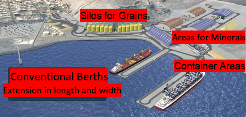
|
Facilities |
20 ft |
40 ft |
|---|---|---|
|
Container Facilities Available |
Yes |
Yes |
|
Container Freight Station (CFS) |
Yes |
Yes |
|
Refrigerated Container Stations |
Yes |
Yes |
|
Other Capacity Details |
||
|
Daily Take Off Capacity |
200 |
200 |
|
Number of Reefer Stations |
24 |
24 |
|
Emergency Take-off Capacity |
100 |
100 |
|
Off take Capacity of Gang Shift |
100 |
100 |
Customs Guidance
SUNAT Customs has an office near the port administration offices where you can carry out all kinds of customs operations aimed at the import / export of goods and supplies through the Port of Salaverry. The hours of attention as in all customs for documentary procedures is from Monday to Friday from 8 in the morning to 6 in the afternoon. Any query on the customs website is: www.sunat.gob.pe
For more information on customs in Peru, please see the following link: 1.3 Customs Information.
Terminal Information
Multipurpose Terminal
The Salaverry port terminal is in the La Libertad region and will have new infrastructure to meet a demand for greater cargo transportation. In addition, it is a multipurpose port, with the capacity to transport all types of cargo, such as minerals, grains and perishable products. During the concession period, the infrastructure improvements and the implementation of equipment that will raise the port terminal's operating standards from the first five years.
Grain and Bulk Handling
For grains (corn and wheat) it has 24 silos with a capacity of 60,000 metric tons. For the handling of Soybeans, it has a capacity of 40,000 metric tons, for the storage of fertilizers there is a maximum capacity of 60,000 metric tons, for the mineral concentrate it has a storage capacity of 30,000 metric tons.
Main Storage Terminal
Due to the fact that the port handles more grains, fertilizers, minerals, coal and it also has container movement but it is minimal, it has different areas to store these types of materials. The central roofed warehouse has 2,325 square meters, for grains (corn and wheat) it has 24 silos with a capacity of 60,000 metric tons. For the handling of Soybeans, it has a capacity of 40,000 metric tons, for the storage of fertilizers there is a maximum capacity of 60,000 metric tons, for the mineral concentrate it has a storage capacity of 30,000 metric tons. It also has two areas for container storage with a total of 25,700 square meters available.
|
Storage Type |
Number of Storage Facilities |
Area (m2) |
|---|---|---|
|
Bagged Cargo |
Main warehouse with roof |
2,325 |
|
Refrigerated Cargo |
N/A | |
|
General Cargo |
24 silos with a capacity for 60,000 MT of corn and wheat 1 warehouse for soy with capacity for 40,000 MT 1 warehouse for fertilizers with capacity for 60,000 MT 1 warehouse for minerals with capacity for 30,000 MT Coal storage slabs with capacity for 30,000 MT Zone No. 5 Containers 6,000 sq. meters Zone No. 6 Containers 19,782 sq. meters |
Stevedoring
In the Salaverry Multipurpose Port Terminal, all stevedoring services are in charge of the same port. They handle all the internal services of the port; any need or requirement has to be communicated to the port administration. Due to the type of concession with the Peruvian state, the operator can offer the same all the regular, special and complementary services of the port, except the pilotage and towing of the ships that is provided by one of the associated companies of the port concessionaire, we refer to the company Tramarsa.
Hinterland Information
As is normal in the ports in Peru, the containers leave the customs to bonded customs warehouses, where the goods are checked. This is at the choice of the importer / exporter who chooses where they can take their cargo. In the vicinity of the port there are several companies that offer this type of services and they are reliable companies. The movement of bulk cargo is collected from the dock of warehouses, silos or certain areas. But always in coordination with SUNAT customs, the movement of this type of merchandise is carried out.
Port Security
The Port of Salaverry has good port security, applies a strict Access Regulation to its facilities, has a private security service, has video surveillance cameras and also has a National Police station. It is governed by the protocols required by the APN (National Port Authority), which apply to ports with services to foreign vessels.
|
Security |
|
|---|---|
|
ISPS Compliant |
Yes |
|
Current ISPS Level |
Level 2 |
|
Police Boats |
No |
|
Fire Engines |
No |
2.2 Peru Puerto de Ilo (Español)
Descripción general del puerto
El puerto de Ilo se ubica en el sur del Perú en la región Moquegua, ciudad, distrito y provincia de Ilo. Cuenta con un muelle multipropósito tipo espigón de atraque directo para naves de alto bordo, con una capacidad de atender naves de hasta 35.000 DWT. Cuenta con áreas de almacenamiento sin techo de 38.360 m2, zona techada de 8.540 m2, y un almacén techado de 1.634 m2, con un periodo libre de almacenamiento según tarifario de empresa nacional de puertos del Perú de 365 días.
Sitio web del puerto: http://www.enapu.com.pe/web/index.php
Información importante del puerto también puede encontrarse en: http://www.maritime-database.com
|
Contacto y ubicación del puerto |
|
|
País |
Ilo |
|
Provincia o Distrito |
Ilo |
|
Pueblo o ciudad (más cercana) con distancia (km). |
Distancia desde el Puerto de Ilo a ciudad de La Paz. Carretera: 513 km |
|
Nombre completo del puerto. |
Puerto de Ilo. |
|
Latitud. |
-17.68334 |
|
Longitud. |
-71.37181 |
|
Entidad administradora o autoridad portuaria (si hay más de un operador, desglosar por zona de operaciones) |
Empresa Nacional de Puertos (ENAPU S.A.). |
|
Persona de contacto encargada de administración |
TISUR: Juan Ramón Arrisueño, Presidente Luis Alfonso Suazo, Gerente General. |
|
Aeropuerto más cercano y Aerolíneas frecuentes desde/hacia destinos
|
Nombre del Aeropuerto: Aeropuerto Internacional de Tacna. Aerolíneas: LATAM Airlines, Viva Air, Viva Colombia, Peruvian Airlines. Operan solo vuelos nacionales (Lima). |
Foto del puerto
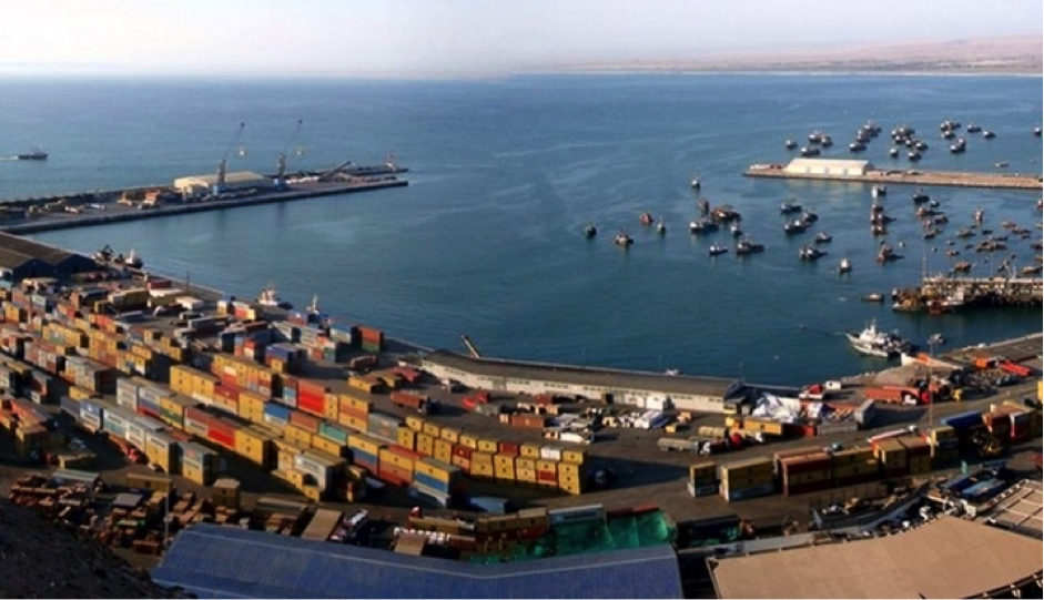
Infraestructura muelles y amarraderos
|
Muelle / Terminal |
Longitud (mts) |
Calado (mts) |
Capacidad (TM) |
|
Muelle de atraque directo tipo espigón |
302 |
n/a |
n/a |
|
Amarradero 1 – A |
200 |
10,9 |
35.000 |
|
Amarradero 2 - B |
200 |
10,9 |
35.000 |
|
Amarradero 3 – C |
100 |
4,8 |
20.000 |
|
Amarradero 4 - D |
100 |
8,2 |
20.000 |
|
Rampa de desembarco |
60 |
3,7 |
n/a |
Descripción y contactos de empresas clave.
ENAPU S.A., La Empresa Nacional de Puertos S.A. de conformidad con el Decreto Legislativo N.º 098 cumple con la misión de administrar, operar y mantener las Terminales Portuarias de la República del Perú, brindando servicios a los movimientos de naves y cargas del comercio exterior peruano.
Para mayor información sobre contactos de puertos, por favor referirse al siguiente link: 4.4 Bolivia Lista de Contactos de Empresas Portuarias
Desempeño del Puerto
En 2018, el movimiento de carga en la Terminal Portuaria de Ilo representó el 11% (331 420 TM) de las operaciones de ENAPU S.A. Este resultado situó a la Terminal Portuaria de Ilo entre los tres puertos de mayor actividad productiva de ENAPU S.A.
Durante el 2018, se suscribieron convenios específicos de cooperación interinstitucional entre ENAPU S.A. y la Administración de Servicios Portuarios de Bolivia (ASP-Bolivia) con la finalidad de que la carga boliviana de importación y exportación utilicen las instalaciones de la Terminal Portuaria de Ilo para su comercio internacional.
|
Restricciones Estacionales |
||
|
|
Si / No |
Período de tiempo |
|
Temporada de lluvias |
No |
En Ilo, los veranos son calientes, áridos y mayormente nublados y los inviernos son largos, frescos, secos y mayormente despejados. |
|
Campañas de importación importantes |
No |
|
|
Inserte otra(s) restricción(es) si es necesario. |
No |
|
|
Manejo de cifras año 2018 |
|
|
Escalas de barcos comerciales |
146 |
|
Tráfico de contenedores (TEUs) |
5.295 |
|
Manejo de cifras de carga total |
|
|
Gestión 2017 (TM) |
317,823 |
|
Gestión 2018 (TM) |
331,523 |
Tarifas de descarga y gastos de manipulación en las terminales
Especificaciones de atraque
|
Tipo de atraque: |
Cantidad |
Longitud (mts) |
Calado máximo (mts) |
Comentarios |
|
Atraque convencional |
4 |
600 |
10,9 |
En uso continuo |
|
Muelle de contenedores |
2 |
200 |
10,9 |
En uso continuo |
|
Atracadero de barco granelero |
2 |
200 |
10,9 |
En uso continuo |
|
Atraque de remolcadores |
Desconocido |
n/a |
n/a |
n/a |
|
Barcazas de agua |
1, rampa de desembarco |
60 |
3,7 |
En uso continuo |
Muelles de carga general
|
Tipo de Carga |
Identificación de Muelle |
|
Importaciones – Carga en bolsas |
Muelle 1 – A y 2 - B |
|
Exportaciones – Carga en Bolsas |
Muelle 1 – A y 2 - B |
|
Importaciones y Exportaciones – Ro-Ro |
Una rampa de desembarco |
|
Otras Importaciones |
Muelle 3 – C y 4 - D |
Equipo de manipulación portuaria
Todos los equipos y maquinaria de la Terminal Portuaria de Ilo son de carácter privado, perteneciendo estos a ENAPU S.A.
|
Equipo |
Disponibilidad (Si / No) |
Cantidad total y capacidad disponible |
Comentarios sobre el actual y el uso real |
|
Grúas de muelle |
Si |
1 unidad, Capacidad de 18 TM. |
En uso continuo |
|
Grúas Puente de contenedores |
Desconocido |
n/a |
n/a |
|
Grúas móviles portacontenedores |
Si |
Desconocido |
En uso continuo |
|
Reachstacker |
Si |
1 unidad. Grúa Kalmar de 45 TM. |
En uso continuo |
|
Ro-Ro Tugmaster (con remolque) |
Desconocido |
n/a |
n/a |
|
Elevador de granos con máquinas embolsadoras |
Si |
1 unidad |
En uso continuo |
|
Carretillas elevadoras |
Si |
11 unidades, capacidad entre 2.200 y 20 TM c/u. |
En uso continuo |
|
Terminal Truck |
Si |
4 unidades, capacidad de 40 TM c/u |
En uso continuo |
|
Tractores |
Si |
7 unidades, capacidad de 2,27 TM c/u |
En uso continuo |
|
Balanza Camionera Electrónica Computarizada |
Si |
2 unidades, capacidad de 100 TM c/u |
En uso continuo |
Instalaciones para el manejo de contenedores
|
Instalaciones |
20 ft |
40 ft |
|
Instalaciones de contenedores disponibles |
Área de 17.000 m2 para contenedores llenos y vacíos. |
|
|
Estación de carga y descarga de contenedores (CFS) |
Área de 17.000 m2 para contenedores llenos y vacíos. |
|
|
Estación de carga y descarga de contenedores refrigerados (CFS) |
Área de 17.000 m2 para contenedores llenos y vacíos. |
|
|
Otros datos de capacidad (TM al año) |
1.400.000 |
|
|
Capacidad
diaria |
Desconocido |
Desconocido |
|
Número de estaciones de
frigoríficos |
60 tomacorrientes de 440 V., en módulos de 6 unidades
|
|
|
Capacidad de despegue de emergencia |
Desconocido |
Desconocido |
|
Capacidad de zarpe de la
cuadrilla |
Desconocido |
Desconocido |
Guía de aduanas
La carga Bolivia que llega o sale del puerto Arica, se tramita a través de la Administradora de Servicios Portuarios Bolivia (ASPB), que es el Agente Aduanero del Estado de Bolivia.
Importaciones:
- Recepción, verificación, custodia, control, almacenamiento y certificación de todo tipo de mercancías y/o bienes en tránsito hacia Bolivia.
- Estiba y desestiba de carga.
- Porteo y acopio en almacén.
- Planificación de despacho de carga a destino y en la empresa de transporte elegida por el consignatario.
- Almacenamiento sin costo por 365 días en Arica y Antofagasta, excepto carga peligrosa (IMO).
Exportaciones:
- Planificación e internación de mercancía al Puerto.
- Recepción, verificación, custodia, control y elaboración de la Póliza de Tránsito (Antofagasta y Arica).
- Consolidación de la mercancía.
- Traslado a la zona de stacking en coordinación con las navieras y el transporte terrestre.
- Envío de documentos al exportador.
- Almacenamiento sin costo por 60 días en los puertos de Arica y Antofagasta, excepto carga peligrosa (IMO).
Para mayor información sobre contactos de aduanas, por favor referirse al siguiente link: 1.3 Bolivia Información Aduanera
Información de terminales
Posee dos muelles, ambos de concreto y de tipo espigón. Uno es de propiedad de la Empresa Nacional de Puertos (ENAPU) y el otro de la minera Southern Copper Corporation.
El primero, de 302 metros de largo y 27 de ancho, moviliza todo tipo de mercaderías, siendo el sexto del país en movimiento total de carga.
El segundo muelle, de 180 metros de largo y 20 de ancho, es empleado por Southern para exportar su producción de cobre e importar los insumos que requiere en sus operaciones.
Terminal de almacenamiento principal
|
Almacén Techado |
Área (m2) |
Tipo de carga |
Capacidad |
||
|
TM |
TEUs |
Niveles |
|||
|
1 |
1.634 |
Mercadería General. |
3.000 |
n/a |
n/a |
|
Zona Techada |
Área (m2) |
Tipo de carga |
Capacidad |
||
|
TM |
TEUs |
Niveles |
|||
|
5 |
8.540 |
Vehículos, Mercadería General, Gráneles |
22.950 |
100 |
2 |
|
Zonas sin Techo |
Área (m2) |
Tipo de carga |
Capacidad |
||
|
TM |
TEUs |
Niveles |
|||
|
1 |
1.200 |
Mercadería General, Contenedores Llenos y Vacíos. |
2.755 |
150 |
3 |
|
2 |
4.800 |
Mercadería General, Contenedores Llenos y Vacíos. |
20.000 |
600 |
3 |
|
3 |
11.000 |
Mercadería General, Contenedores Llenos y Vacíos. |
60.000 |
1200 |
3 |
|
4 |
11.360 |
Vehículos y Granos |
80.000 |
700 |
2 |
|
6 |
12.500 |
Mercadería General y Contenedores Vacíos |
150.000 |
n/a |
n/a |
Estiba y desestiba
Entidades que ofrecen el servicio:
Información de zonas del interior
Áreas de influencia: Comprende los departamentos de Puno, Tacna, Moquegua, Arequipa, Cuzco y el Estado Plurinacional de Bolivia.
|
Ciudad |
Terrestre (km) |
Marítimo |
|
Moquegua |
90 |
n/a |
|
Tacna |
159 |
n/a |
|
Arica |
205 |
86 millas náuticas |
|
Matarani |
300 |
63 millas náuticas |
|
Arequipa |
359 |
n/a |
|
Desaguadero |
400 |
n/a |
|
La Paz |
500 |
n/a |
|
Puno |
680 |
n/a |
|
Cuzco |
1.050 |
n/a |
|
Iñapari |
1.200 |
n/a |
|
Lima |
1.269 |
n/a |
|
Callao |
1.269 |
516 millas náuticas |
Seguridad portuaria
|
Seguridad |
|
|
Cumplimiento de las normas ISPS (PBIP) |
Si |
|
Nivel actual de ISPS. (Código internacional para la protección de los buques y de las instalaciones portuarias). |
n/a |
|
Botes patrulleros |
Si |
|
Camiones de bomberos |
Si |
Información de apoyo
2.1.7 Peru Port of Pisco
Port Overview
The port of Pisco, officially the General San Martín Port Terminal, is a maritime port on the central coast of Peru, in the south-eastern Pacific. It islocated in Punta Pejerrey, District of Paracas in the Province of Pisco, Region of Ica.
In 2018, the port movement in the port of Pisco was 3,217 TEU, ranking 105th on the list of port activity in Latin America and the Caribbean. Due to its proximity to the Port Terminals of Callao, it is projected as a complementary docking terminal, in the event of occasional requests from ships with cargo destined for the capital of the Republic. The port activity of the General San Martín Port Terminal is of great importance in the fishing and agro-industrial activities, metallurgical and mining industries in the area. The products it mobilizes are related to the socioeconomic development of the departments of Ica, Ayacucho, Huancavelica and the north of Arequipa.
Port website: www.tpparacas.com.pe
Key port information may also be found at: http://www.maritime-database.com
|
Port Location and Contact |
|
|---|---|
|
Country |
Peru |
|
Province or District |
Paracas - Pisco |
|
Nearest Town or City with Distance from Port |
Pisco (35 km) |
|
Port's Complete Name |
Terminal Portuario General San Martin - Paracas |
|
Latitude |
-13.709828 |
|
Longitude |
-76.218628 |
|
Managing Company or Port Authority |
Terminal Portuario Paracas S.A. |
|
Management Contact Person |
Jorge Luis Arce Almenara +511 7084600 |
|
Nearest Airport and Airlines with Frequent International Arrivals/Departures |
Aeropuerto Internacional De Pisco Cap. Renan Elias LatAm Airlines, Sky Airlines |
Port Picture
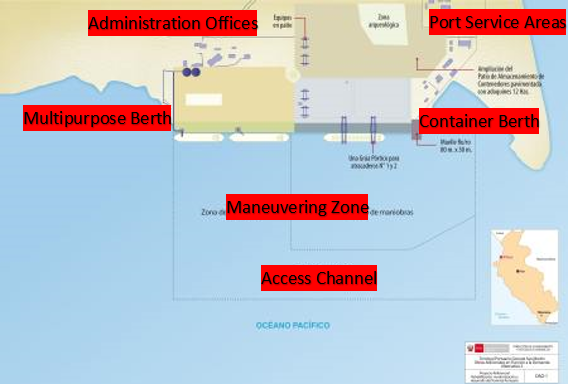
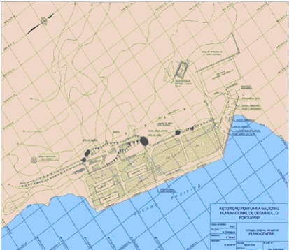
Description and Contacts of Key Companies
The General San Martin Port Terminal, being a multipurpose terminal, can offer their services to the following types of cargo: Fractional, Bulk, Roro, Containers, Passengers and Project.
Project Cargo
It has a platform that allows us to unload and maintain overweight and / or oversized loads for a certain time thanks to the use of a special access ramp. Within the type of project cargo, the following stand out: transformers, windmills (WTG) and heavy vehicles for mining and other industries in our area of influence.
Passengers
It serves cruise ships from all over the world and we provide facilities for tourists to enter and exit safely and comfortably via the port. Likewise, we offer the possibility to tourism companies, local companies and artisans that can promote their services and products through a space strategically placed in front of the tourist ship.
Containerized Cargo
The service includes unloading, storage, emptying and shipping of containers (dry, refrigerated and frozen). We also have racks with direct power connection that includes their monitoring. In addition, we have a 3,000 m2 closed and covered warehouse for the consolidation and deconsolidation of containers.
Ro - Ro Cargo
We offer rolling load services for all types of self-propelled vehicles (cars, bus, trucks, tractors, among others).
Bulk or Grains Cargo
It includes the loading and unloading of bulk. The load is characterized by being varied and homogeneous. Among the cargoes operated in the port are: scrap metal, salt, grains such as corn, soybeans and sunflower seeds.
Fractional Cargo
Includes the loading or unloading of various types of merchandise individually. The main merchandise mobilized are: cement, nitrate, wire rod, plates, rods, steel products, among others.
Practice Service Companies
- Trabajos Marítimos S.A. - TRAMARSA
- Practicos Maritimos S.A.C. – PRAMAR S.A.C.
- PILOTOS DEL SUR SOUTH PILOTS S.A.
Towing Service Companies
- INVERSIONES MARITIMAS CPT PERU (INMARSA)
- PETROLERA TRANSOCEANICA S.A.
- EMPRESA MARITIMA DEL PERU S.A.
Port website: www.tpparacas.com.pe
For more information on port contacts, please see the following link: 4.4 Port and Waterways Companies Contact List.
Port Performance
In 2020, the Paracas Terminal served 148 ships, a lower number in 14 ships compared to the previous year, which represented a reduction of 8.6%. The decrease in the attention of ships can be explained by the paralysis of the economy that was experienced in part of the year 2020 as a result of the measures taken by the governments of the different countries in order to stop the spread of COVID-19, which affected the operations of some of the Concessionaire's clients.
During 2020, the Concessionaire mobilized 9.6 thousand TEU11 corresponding to the standard service of loading / unloading full containers, which represented an increase of 51% compared to the previous year. This service presents as main container shipping operation, where 40-foot containers had a 96.5% participation. It is important to note that in 2020 the total cargo traffic was 1.5 million tons, an amount 3.2% lower than that registered in the previous year (1.6 million tons).
|
Seasonal Constraints |
||
|---|---|---|
|
Occurs |
Time Frame |
|
|
Rainy Season |
No |
N/A |
|
Major Import Campaigns |
Yes |
From September to December |
|
Other Comments |
This situation can be explained for the measures taken by the government to counteract the effects of COVID-19, such as the closure of borders and mandatory immobilization at the national level. Port operations restarted in June 2020. |
|
|
Handling Figures for 2020 |
|
|---|---|
|
Vessel Calls |
148 |
|
Container Traffic (TEUs) |
9,600 |
|
Handling Figures Bulk and Break Bulk for 2020 |
|
|---|---|
|
Bulk (MT) |
307,400 MT |
|
Break bulk (MT) |
362,700 MT |
Discharge Rates and Terminal Handling Charges
For information on port rates and charges, please see the following link:
https://www.tpparacas.com.pe/tarifas/
Berthing Specifications
|
Type of Berth |
Quantity |
Length |
Maximum Draft |
Comments |
|---|---|---|---|---|
|
Conventional Berth |
1 |
350 m |
14m |
It has two multipurpose moorings for ships. |
|
Container Berth |
N/A |
|
||
|
Silo Berth |
N/A |
|
||
|
Berthing Tugs |
N/A |
|
||
|
Water Barges |
N/A |
|
The TPGSM concessionaire increased the existing berth by 175 meters as well as increasing the draft from 10 to 14 meters helps a lot to bring ships of greater capacity, likewise the increase of 4,600 square meters to the foreport area facilitates loading manoeuvres and ship unloading.
General Cargo Handling Berths
|
Cargo Type |
Berth Identification |
|---|---|
|
Imports - Bagged Cargo |
743,922 MT – Multipurpose berth |
|
Exports - Bagged Cargo |
261,378 MT – Multipurpose berth |
|
Imports and Exports - RoRo |
No Activities in 2020 |
|
Other Imports |
In 2020 the TPGSM did not transport liquid bulk cargo |
Port Handling Equipment
As a result of the investments that the concessionaire has been making in the TPGSM, by 2020 said terminal has the following assets such as Mobile Cranes, Transtainers, Forklifts, Generators, Grain Hoppers, Grain Warehouse, Truck Scale, etc.
|
Equipment |
Available |
Total Quantity and Capacity Available |
Comments on Current Condition and Actual Usage |
|---|---|---|---|
|
Dockside Crane |
No |
N/A | |
|
Container Gantries |
No |
N/A | |
|
Mobile Cranes |
Yes |
2 Liebherr LHM 550 |
Good Condition |
|
Reachstacker |
Yes |
1 Reach Stacker |
Good Condition |
|
RoRo Tugmaster (with Trailer) |
Yes |
6 Tugmaster |
Good Condition |
|
Grain Elevator with Bagging Machines |
Yes / No |
5 Bulk Hoppers |
Good Condition |
|
Transtainer |
Yes |
2 Transtainers |
Good Condition |
|
Forklifts |
Yes |
4 Forklift |
Good Condition |
Container Facilities
The TPM has allocated an area of 4 hectares for the storage of containers, within the port facilities.
|
Facilities |
20 ft |
40 ft |
|---|---|---|
|
Container Facilities Available |
Yes |
Yes |
|
Container Freight Station (CFS) |
Yes |
Yes |
|
Refrigerated Container Stations |
Yes |
Yes |
|
Other Capacity Details |
||
|
Daily Take Off Capacity |
40 |
40 |
|
Number of Reefer Stations |
1 Station x 25 containers |
1 Station x 25 containers |
|
Emergency Take-off Capacity |
60 |
60 |
|
Off take Capacity of Gang Shift |
20 |
20 |
Customs Guidance
Within the facilities of the Terminal Portuario General San Martin (Pisco), there are the offices of the Customs, which belong to SUNAT Aduanas. All kinds of customs operations that are required are carried out there.
For more information on customs in Peru, please see the following link: 1.3 Customs Information.
Terminal Information
Multipurpose Terminal
In 2020, the Paracas Terminal served 148 ships, a lower number in 14 ships compared to the previous year, which represented a reduction of 8.6%. The decrease in the attention of ships can be explained by the paralysis of the economy that was experienced in part of the year 2020 as a result of the measures taken by the governments of the different countries in order to stop the spread of COVID-19, which affected the operations of some of the Concessionaire's clients.
Shipping lines that dock at the terminal can be classified according to the type of online or tramp service. The first one is associated with ships that are going to load containerized cargo and ships that carry passengers. In 2020, these types of ships represented 34% of the total number of ships that docked at the TPGSM, within which container ships represented a greater relative importance, 90.2%, in relation to passenger ships (cruise ships) . The rest of the vessels, 66%, corresponded to vessels of the tramp service type.
Grain and Bulk Handling
In 2020 solid bulk cargo traffic moved 257.9 thousand tons in 2020. This type of cargo is characterized by being concentrated in the import cargo operation. In 2020 this operation represented 74.3% of the solid bulk cargo mobilized in that year.
Regarding the products that have been mobilized the most, four (4) products stand out due to their volume: hard yellow corn, pig iron, ferrous scrap and industrial solar salt; These four products represented 83.8% of the solid bulk cargo handled by the TPGSM.
In 2020 the TPGSM did not transport liquid bulk cargo. It should be noted that the liquid bulk cargo that has been mobilized in previous years has been destined for the export of crude fish oil, destined for countries such as Denmark and Norway.
Main Storage Terminal
The multipurpose terminal TPM can handle the following types of cargo: Breakdown cargo, Bulk cargo, Roro cargo, Containers, Passengers, Project cargo. They have a platform that allows to unload and maintain overweight and / or oversized loads for a certain time thanks to the use of a special access ramp.
|
Storage Type |
Number of Storage Facilities |
Area (m2) |
|---|---|---|
|
Bagged Cargo |
Warehouse for load / unload Cargo |
3,000 |
|
Refrigerated Cargo |
N/A | |
|
General Cargo |
Area for Grain and Bulking |
6,000 |
Stevedoring
The stowage activities at the Pisco Port Terminal (TPGSM) are provided by the same port, the loading and unloading of ships are carried out by the same port personnel. It must be taken into account that they are mono concessions granted by the state on the operations of the port. The only services that are provided by third parties are pilotage and towing.
Hinterland Information
Most companies use bonded customs warehouses to store their cargo in containers, the cargo arrives at the port and the importer or cargo owner indicates where they will carry out their customs clearance or exploration procedures for the containers. The cargo leaves the port and they are taken to these warehouses and there the entire import or export process is carried out. These consolidated warehouses belong to other companies that have nothing to do with the port concession. The port only loads or unloads the ships and delivers the containers to these shipping agencies, which are the ones that move the containers to these bonded warehouses of customs.
Port Security
Port security has a security services company and also a national police office and Peruvian Navy, the port has a video surveillance system and maintains 24-hour security. In addition, it has the support of the National Police that, outside of the internal and external control of the port, does intelligence work to prevent smuggling and trafficking in narcotics or controlled substances.
|
Security |
|
|---|---|
|
ISPS Compliant |
Yes |
|
Current ISPS Level |
Level 2 |
|
Police Boats |
No |
|
Fire Engines |
No |
2.2 Peru Aviation
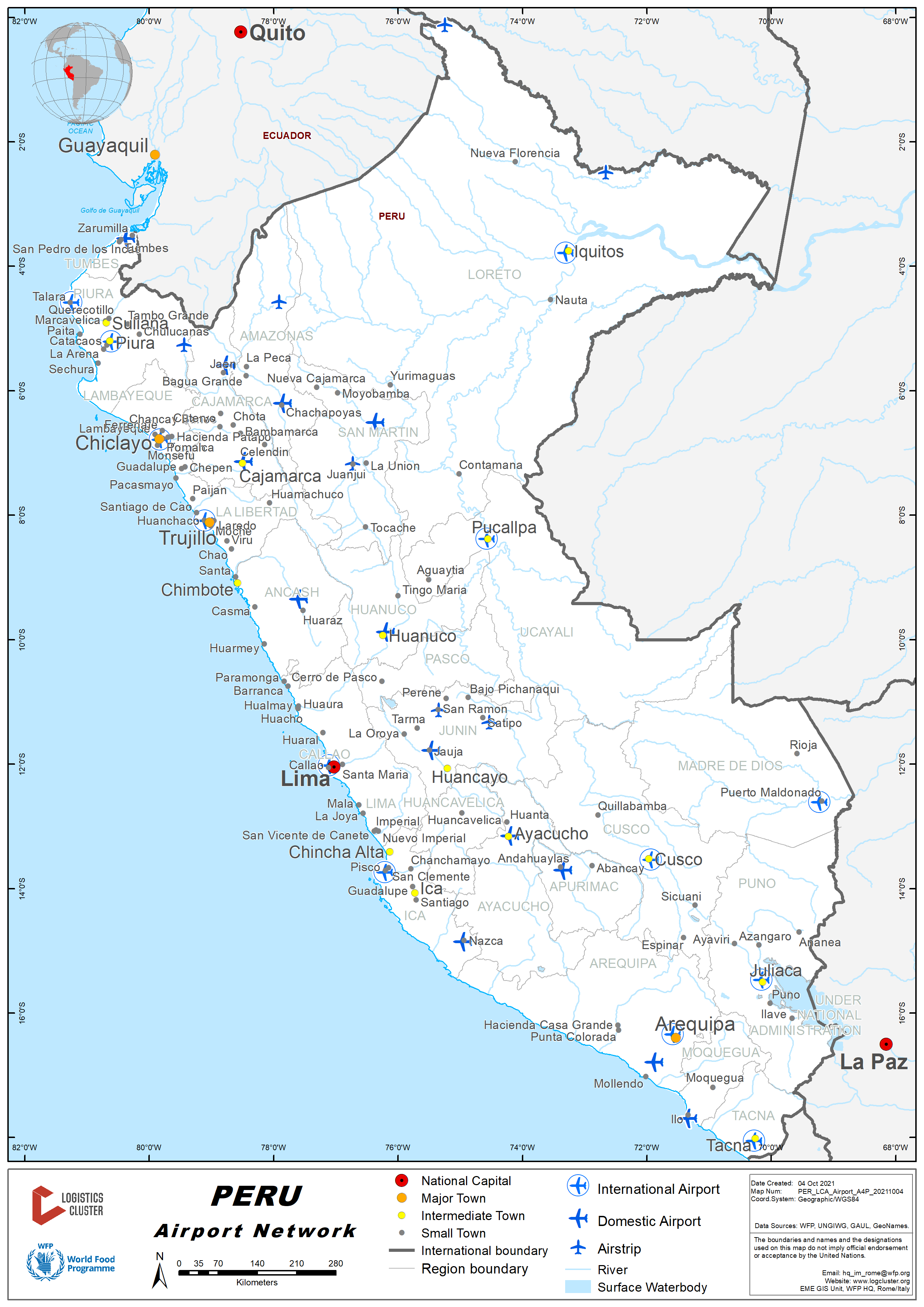
Key airport information may also be found at: http://worldaerodata.com/
General Directorate of Civil Aviation
It is the technical regulatory body at the national level exercised by the Civil Aviation Authority of Peru; it is responsible for regulating, monitoring, supervising, sanctioning, as well as developing strategies to ensure that civil aeronautical activities and civil air navigation achieve a level of acceptable operational safety within international standards. It depends on the Vice-Ministerial Office of Transport of the Ministry of Transport and Communications. The directorates or organic units dependent on the General Directorate of Civil Aeronautics are the following:
Directorate of Aeronautical Regulation, Promotion and Development
Responsible for the formulation of standards, regulations and other provisions related to civil aeronautics and airport infrastructure activities. It promotes the development of civil aviation in Peru and proposes policies for entering the commercial aviation market.
- Peruvian Aeronautical Regulations (RAP)
- Complementary Technical Standards (NTC)
- Advisory Circulars (CA)
- Pre Publications
- Technical Manuals
Directorate of Certifications and Authorizations
In charge of the evaluation and management of the authorization and supervision of the operation of the aircraft in the Peruvian airspace. Manages and grants traffic rights and monitors their compliance. It proposes commercial air policies, certifies aerodromes and related services.
- Licenses
- Certified and / or Authorized Companies
- List of Type Certificate
- Authorization of Schools and Training Centers
- Revocations
Aeronautical Safety Directorate
Responsible for the surveillance, supervision and control of compliance with safety standards and the provision of air navigation services. It grants, validates and renews the certificates of technical suitability of aeronautical personnel and material, aeronautical operators and other related parties. Collaborates in the investigation of civil aviation accidents.
- National Air Navigation Plan (PNNA)
- Aviation Security and Dangerous Goods
- Airworthiness Inspector Manual
- Operations Inspector Manual
- Circular Trades
- Aerodrome Integrity Data Verification
Dirección General de Aeronáutica Civil (General Directorate of Civil Aviation)
Ministerio de Transportes y Comunicaciones
Address: Jr. Zorritos N° 1203 LIMA 15082
Telephone: (511) 615 7966: (511) 615 7800 extension 1173
Email: dgac@mintc.gob.pe
AFTN: SPLIYAYX
Dirección de Seguridad Aeronáutica (Directorate of Aeronautical Security)
Address: Jr. Zorritos N° 1203 LIMA 15082
Telephone: (511) 615 7450 extension 1392: (511) 615 7800 extension 1372
Coordinación Técnica de Navegación Aérea (Technical Coordination of Air Navigation)
Telephone: (511) 615 7881
Telefax: (511) 615 7869
AFTN: SPLIYAYN
Dirección de Authorizations y Certificaciones (Directorate of Authorizations and Certifications)
Address: Jr. Zorritos N° 1203 LIMA 15082
Telephone: (511) 615 7850: (511) 615 7800 extension 1192, 1391, 1390, And 1392
Donald Castillo Gallegos
Director General
Email: dcastillo@mtc.gob.pe
Telephone: (511) 615 7800, Extension 1173, 1208
For more information on government agency and airport company contact information, please see the following links: 4.1 Government Contact List and 4.5 Airport Companies Contact List.
Procedures for Foreign Registered Aircraft
Entry Requirements and Permits of Peru
(Extracted from the Peruvian Aeronautical Information Publication (AIP) Gen 1.2, Entry, Transit, and Departure of Aircraft)
The RAP - Aeronautical Regulations of Peru that are mentioned are available and permanently updated on the Internet: http://www.mtc.gob.pe/dgac.html
Flight Permits
- Literal g) of article 9 and numeral 88.2 of article 88 of Law No. 27261, Civil Aeronautics Law of Peru (05.10.2000).
- Articles 170, 178, 179 and 180 of the Regulations of the Civil
Aeronautics Law, approved by Supreme Decree No. 050-2001-MTC
(12/26/2001)
- Request addressed to the Director of Certifications and Authorizations (DCA) of the General Directorate of Civil Aeronautics (DGAC), detailing: Type of activity to be carried out, routes and frequencies or areas of operation, base and sub bases of operation, type and brand of the aircraft (s) that will be used in the activity and term for which the flight permit is requested.
- Simple copy of the aircraft registration certificate or in the case of national aircraft, indicate in the application, the registration number in which the aircraft is registered.
- Simple copy of the airworthiness certificate in the case of foreign registration aircraft.
- Simple copy of the corresponding insurance certificate.
- In the case of a national license: License number of the technical crew. In the case of a foreign license: simple copy of the crewmember’s license.
- Simple copy of the Air Operator Certificate (AOC - Air Operator Certificate) or equivalent document and technical specifications of the operation approved by the competent aeronautical authority, if applicable (Commercial Aviation).
- Indicate the day of payment and the number of proof of payment.
- Gliders, ultra-light aircraft and aircraft up to 1000 kg of empty weight. - S /. 497.00
- Aircraft from 1001 kg to 7000 kg of empty weight. - S /. 976.20
- Aircraft from 7001 kg to 30,000 kg of empty weight. - S /. 1,633.00
- Aircraft of 30,000 kg or more, empty weight. - S /. 3,266.00
- Non-commercial operations such as Ferry, Transfer, Ambulance, Technical Stopovers, etc. - Free
NOTE: Simple copies of the documents are required if they are not in the possession of the DGAC. The deadline to resolve the flight permits is 30 regular calendar days.
All the procedures are presented in the Office of Citizen Services and Document Management, of the Ministry of Transport and Communications, I quote in Jiron Zorritos 1203, Lima.
http://www.gcmap.com/search?Q=country:PE
2.3 Peru Road Network
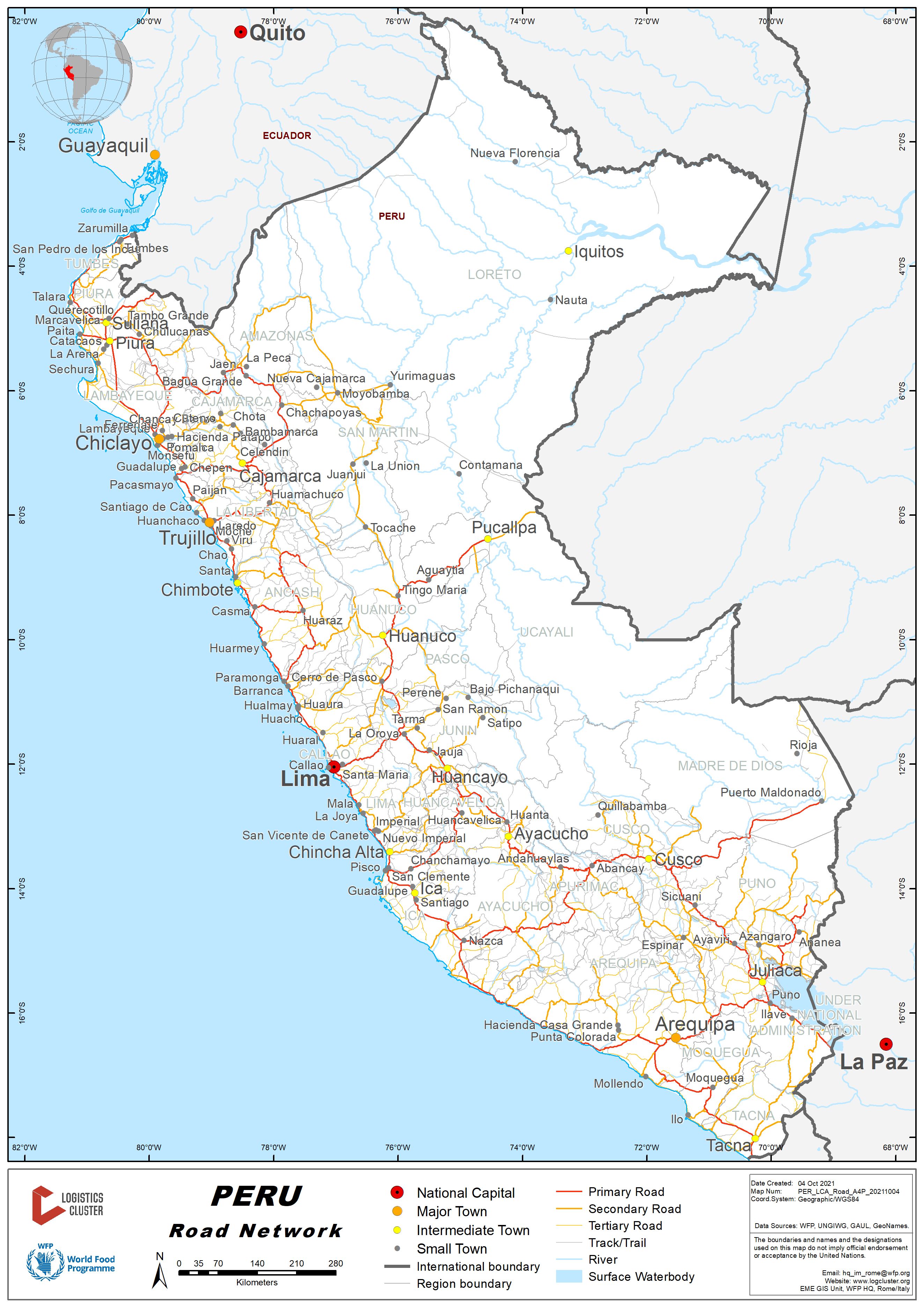
Overview
In Peru, there are different types of roads and tracks, which are accompanied by national, international, departmental or regional and regional or rural routes. Each one of them comprises an efficient transfer to Peruvians, it should also be noted that our country has an extensive area of destinations, and that the Ministry of Transport and Communications (MTC) has implemented an important number of roads and routes that connect with the destinations of each conductor.
The growth of roads and routes in Peru has increased in terms of tourism and intercultural customs with the towns, as well as with the most remote wonders that for more than 50 years have been a point of contact with modernity. However, today there is no way to get to know the whole country, so there are many of the paths that connect you to the destination you are looking for.
The road network of Perú comprises more than 70,000 km of roadways, which are organized by three important groups; Longitudinal, penetration and linkage, each of these is useful to conductors, taking into account the city, department and even the country where they wish to travel.
Main Roads of Peru
Longitudinal Roads
PE – 1: Longitudinal de la Costa: Takes a Peruvian part of the Panamericana Carretera, it divides north and south, this is a totally asphalted road that is composed of 2,375.82 kilometres, which cross through the provinces of Tumbes, Piura, Lambayeque, La Libertad, Ancash, Lima, Ica, Arequipa, Moquegua and Tacna.
PE – 3: Longitudinal de la Sierra: Another one of the most important roads in Peru, this is one of the main ones that runs through the most important cities in the region, at the same time that it is divided into north and south, having as a kilometre 0 to La Oroya, with 3,503 km of extension, 84.1% of asphalted and the rest is not paved. This network pases through: Vado Grande, Huancabamba, Cajamarca, Huaraz, Cerro de Pasco, La Oroya, Huancayo, Huancavelica, Huancabamba, Cajamarca, Huaraz, Cerro de Pasco, La Oroya, Huancayo, Ayacucho, Cusco, Juliaca, Puno y Desaguadero .
PE – 5: Longitudinal de la Selva: And finally, this is the road that runs through the jungle of Peru, a route that goes through the warmest and most tropical cities of the country, with 2,676 km in length and that is located in its totality paved, divided into north and south. Thanks to connecting with many visited destinations and with much intercultural connection, this route passes through Bagua, Jaen, Moyobamba, Tarapoto, Tocache, Camisea and Puerto Prado.
Transverse Roads
PE – 22: Carretera Central: Known also as one of the oldest roads in the country, it runs on a single stretch that departs from the road interchange of Santa Anita (km 0 of the PE -1), and the road to La Oroya (km 0 of 1 to PE -3). At a step of 173.66 kilometres, it offers an easy access and transit route that allows you to visit some places near the capital, crossing Ate, Chosica, Matucana, San Mateo, San Mateo and Morococha.
PE – 30: Carretera de San Juan de Marcona – Iñapari: This is the cross-section of the south, a hill that forms part of the Interoceanic Carretera that connects our country with Brazil, with 1,367.62 kilometres of partially paved road, which runs through the departments de Ica, Ayacucho, Apurímac, Cuzco and Madre de Dios.
The national road network is comprised of national interest, which are formed by three longitudinal axles, called with odd numbers. They are also represented by a shield and are coded with the format PE- x the longitudinal and PE- xx the transversals.
The regional road network, remain limited to a single department or region, where they are represented by an emblem and coded with letters corresponding to the department, 3 digits between 100 and 499.
The rural road network the roads in the local environment, where its function is to articulate the district capitals with the populated centers that are based on the norm of roadways, as zone three affirmed. If they are represented with a circuit, the letters corresponding to the department are coded. Three digits between 500 and 999.
Ministerio de Transportes y Comunicaciones
Jiron Zorritos 1203 – Lima 1 - Peru
Página Web: https://www.gob.pe/mtc
Teléfono: +511 6157800
Director General de Caminos y Ferrocarriles
Nombre: Ing. Carlos Eduardo Lozada Contreras
E-mail: clozada@mtc.gob.pe
Teléfono: +511 6157800 - Anexo 1219
Director de Caminos
Nombre: Lic. Luis Escobar Alarcón
E-mail: lescobar@mtc.gob.pe
Teléfono: +511 6157800 - Anexo 1316
For more information on government contact details, please see the following link: 4.1 Government Contact List.
Distance Matrix
|
Distances from Capital City to Major Towns (km) |
||||||||
|---|---|---|---|---|---|---|---|---|
|
Lima |
Tumbes |
Piura |
Cajamarca |
Arequipa |
Cuzco |
Tacna |
Puno |
|
|
Lima |
1299 |
973 |
856 |
997 |
1153 |
1293 |
1542 |
|
|
Tumbes |
1299 |
283 |
750 |
2265 |
2362 |
2549 |
2591 |
|
|
Piura |
973 |
283 |
496 |
1982 |
2079 |
2266 |
2515 |
|
|
Cajamarca |
856 |
750 |
496 |
1860 |
1957 |
2144 |
2186 |
|
|
Arequipa |
997 |
2265 |
1982 |
1860 |
515 |
284 |
326 |
|
|
Cuzco |
1153 |
2362 |
2079 |
1957 |
515 |
799 |
389 |
|
|
Tacna |
1293 |
2549 |
2266 |
2144 |
284 |
799 |
610 |
|
|
Puno |
1542 |
2591 |
2515 |
2186 |
326 |
389 |
610 |
|
|
Travel Time from Capital City to Major Towns (in Hours) |
||||||||
|---|---|---|---|---|---|---|---|---|
|
Lima |
Tumbes |
Piura |
Cajamarca |
Arequipa |
Cuzco |
Tacna |
Puno |
|
|
Lima |
21.7 |
17.0 |
15.0 |
16.0 |
19.0 |
18.0 |
20.0 |
|
|
Tumbes |
21.7 |
5.0 |
14.0 |
37.0 |
40.0 |
39.0 |
42.0 |
|
|
Piura |
17.0 |
5.0 |
9.0 |
31.0 |
35.0 |
34.0 |
36.0 |
|
|
Cajamarca |
15.0 |
14.0 |
9.0 |
30.0 |
34.0 |
33.0 |
35.0 |
|
|
Arequipa |
16.0 |
37.0 |
31.0 |
30.0 |
9.0 |
5.0 |
5.0 |
|
|
Cuzco |
19.0 |
40.0 |
35.0 |
34.0 |
9.0 |
14.0 |
7.0 |
|
|
Tacna |
18.0 |
39.0 |
34.0 |
33.0 |
5.0 |
14.0 |
7.0 |
|
|
Puno |
20.0 |
42.0 |
36.0 |
35.0 |
5.0 |
7.0 |
7.0 |
|
Road Security
Known as Devil Curve in Peru they are called this way to the areas of highways and roads that are on a curve that is too narrow, which can be at the foot of a slope, which is equivalent to the curve of death in many other countries. According to information from the Highway Police, the Ministry of Transport and Communications, to prevent there are many risks for drivers, and it is for this reason reports on the most dangerous roads in Peru:
Villa El Salvador. (Local Highway), Santiago de Chocorvos. (Local Highway), Pasamayo (National Route PE-1), Arequipa (Interoceanic Route Brazil - Peru), Puno (Interoceanic Route Brazil - Peru), Jauja (National Route PE-22) and Iquitos (Departmental Route LO-104).
Weighbridges and Axle Load Limits
The Bridges inventory conditions in the National Road Network as of 2019 report of the Ministry of Transport and Communications are as follows:
Technical Note:
-Adequate Definitive Bridge: With load design according to current traffic requirements (48 Ton.)
-Final Bridge Not Adequate: With a load design prior to current traffic requirements (<48 Ton.) And more than 30 years old
-Adequate Modular Bridge: Modern and state-of-the-art structure -Non-Adequate Modular Bridge: Old structure that does not comply with current regulations
-Artisan Bridge and others: Provisional structure made of wood, poles, stock of rails and others that are inappropriate for safety and current traffic.
|
Type of Bridge |
Good Condition |
Bad Condition |
Total |
|---|---|---|---|
|
Permanent |
658 |
591 |
1,249 |
|
Modular |
701 |
290 |
991 |
|
Others |
|
1.196 |
1,196 |
|
Total |
1.359 |
2.077 |
3,436 |
|
Axle Load Limits |
Peru |
Bolivia |
Chile |
|---|---|---|---|
|
Truck with 2 Axles |
Vehicle Configuration: C2 Gross Weight: 18 Tons 1st Axis: 7 Tons 2nd Axis :11 Tons |
Vehicle Configuration: 1RS-1RS Gross Weight: 14 Tons 1st Axis: 7 Tons 2nd Axis: 7 Tons |
Vehicle Configuration: Simple + Doble Gross Weight: 11 Tons 1st Axis: 7 Tons 2nd Axis: 4 Tons |
|
Truck with 3 Axles |
Vehicle Configuration: C3 Gross Weight: 25 Tons 1st Axis: 7 Tons 2nd Axis: 9 Tons 3rd Axis: 9 Tons |
Vehicle Configuration: 1RS-1RS-1RS Gross Weight: 21 Tons 1st Axis: 7 Tons 2nd Axis: 7 Tons 3rd Axis: 7 Tons |
Vehicle Configuration: Triple Simple Gross Weight: 19 Tons 1st Axis: 7 Tons 2nd Axis: 7 Tons 3rd Axis: 5 Tons |
|
Truck with 4 Axles |
Vehicle Configuration: C4 Gross Weight: 30 Tons 1st Axis: 7 Tons 2nd, 3rd, and 4th Axis Total: 23 Tons |
Vehicle Configuration: 1RS-1RD Gross Weight: 18 Tons 1st Axis: 7 Tons 2nd Axis: 11 Tons |
Vehicle Configuration: Doble + Doble Gross Weight: 18 Tons 1st Axis: 7 Tons 2nd Axis 11 Tons |
|
Semi-trailer with 3 Axles |
Vehicle Configuration: T2S1 Gross Weight: 29 Tons 1st Axis: 7 Tons 2nd Axis: 11 Tons 3rd Axis: 11 Tons |
Vehicle Configuration: 1RS-1RD-1RS-1RS Gross Weight: 32 Tons 1st Axis: 7 Tons 2nd Axis: 11 Tons 3rd Axis: 7 Tons 4th Axis: 7 Tons |
Vehicle Configuration: Triple + Doble Gross Weight: 25 Tons 1st Axis: 7 Tons 2nd Axis: 7 Tons 3rd Axis: 7 Tons 4thAxis: 4 Tons |
|
Semi-trailer with 4 Axles |
Vehicle Configuration: T2S2 Gross Weight: 36 Tons 1st Axis: 7 Tons 2nd Axis: 11 Tons 3rd Axis: 9 Tons 4th Axis: 9 Tons |
Vehicle Configuration: 1RS-1RD-1RD-1RD Gross Weight: 40 Tons 1st Axis: 7 Tons 2nd Axis: 11 Tons 3rd Axis: 11 Tons 4th Axis: 11 Tons |
Vehicle Configuration: Simple + Doble + Doble + Doble Gross Weight: 39 Tons 1st Axis: 7 Tons 2nd Axis: 11 Tons 3rd Axis: 11 Tons 4th Axis: 10 Tons |
|
Semi-trailer with 5 Axles |
Vehicle Configuration: T2S3 Gross Weight: 43 Tons 1st Axis: 7 Tons 2nd Axis: 11 Tons 3rd, 4th, and 5th Total: 25 Tons |
Vehicle Configuration: 1RS-1RD-1RD-1RS1RD Gross Weight: 43 Tons 1st Axis: 7 Tons 2nd Axis: 11 Tons 3rd Axis: 11 Tons 4th Axis: 14 Tons |
Vehicle Configuration: 1Simple-1Doble-1Doble-1Simple+1Doble Gross Weight: 42 Tons 1st Axis: 7 Tons 2nd Axis: 11 Tons 3rd Axis: 11 Tons 4th Axis: 13 Tons |
|
Semi-trailer with 6 Axles |
Vehicle Configuration: T3S3 Gross Weight: 48 Tons 1st Axis: 7 Tons 2nd Axis: 9 Tons 3rd Axis: 9 Tons 4th, 5th,and 6th Total: 23 Tons |
Vehicle Configuration: 1RS-1RD-1RD-2RD Gross Weight: 45 Tons 1st Axis: 7 Tons 2nd Axis: 11 Tons 3rd Axis: 11 Tons 4th Axis: 18 Tons |
Vehicle Configuration: 1Simple-1Doble-1Doble-2Dobles Gross Weight: 45 Tons 1st Axis: 7 Tons 2nd Axis: 11 Tons 3rd Axis: 11 Tons 4th Axis: 18 Tons |
|
Truck & Drawbar Trailer with 4 Axles |
Vehicle Configuration: C2R2 Gross Weight: 40 Tons 1st Axis: 7 Tons 2nd Axis: 11 Tons 3rd Axis: 11 Tons 4th Axis: 11 Tons |
N/A | N/A |
|
Truck & Drawbar Trailer with 5 Axles |
Vehicle Configuration: C3R2 Gross Weight: 47 Tons 1st Axis: 7 Tons 2nd Axis: 9 Tons 3rd Axis: 9 Tons 4th Axis: 11 Tons 5th Axis: 11 Tons |
N/A | N/A |
|
Truck & Drawbar Trailer with 6 Axles |
Vehicle Configuration: C3R3 Gross Weight: 48 Tons 1st Axis: 7 Tons 2nd Axis: 9 Tons 3rd Axis: 9 Tons 4th Axis: 11 Tons 5th Axis: 6 Tons 6th Axis: 6 Tons |
N/A | N/A |
|
Truck & Drawbar Trailer with 7 Axles |
Vehicle Configuration: C3R4 Gross Weight: 48 Tons 1st Axis: 7 Tons 2nd Axis: 9 Tons 3rd Axis: 9 Tons 4th Axis: 11 Tons 5th, 6th,and 7th Total: 12 Tons |
N/A | N/A |
National Road Network
The National Road Network, are the highways of national interest formed by three main longitudinal axes, named with odd numbers. They are three longitudinal axes and have the following composition:
1.) PE-1 Longitudinal de la Costa, is the Pan-American Highway in Peru, with an extension of 2,364 kilometres, it is divided into:
- PE-1N North Pan-American Highway
- PE-1S Carretera Panamericana Sur
2.) PE-3 Longitudinal de la Sierra, with an extension of 3,503 kilometers, is divide into:
- PE-3N Longitudinal de la Sierra Norte
- PE-3S Longitudinal de la Sierra Sur
3.) PE-5 Longitudinal de la Selva, is the Carretera Marginal de la Selva, with an extension of 1.809 kilometers, it is divided into:
- PE-5N Longitudinal de la Selva Norte
- PE-5S Longitudinal de la Selva Sur
The three longitudinal axes have an additional extension of variants and branches of 9,692 kilometres.
There are 20 of Transversal Highways, joining two or more departments or regions, coded with even numbers:
PE-02, PE-02A, PE-02B, PE-04, PE-04A, PE-04B, PE-04C, PE-06, PE-06A, PE-06B, PE-08, PE-08A, PE- 08B, PE-08C, PE-10, PE-10A, PE-10B, PE-10C, PE-14, PE-14A, PE-14B, PE-14C, PE-16, PE-18, PE-18A, PE-18B, PE-18C, PE-20, PE-20A, PE-20B, PE-20C, PE-22, PE-22A, PE-22B, PE-24, PE-24A, PE-26, PE- 26A, PE-26B, PE-28, PE-28A, PE-28B, PE-28C, PE-28D, PE-28E, PE-28F, PE-28G, PE-30, PE-30A, PE-30B, PE-30C, PE-32, PE-32A, PE-34, PE-34A, PE-34B, PE-34C, PE-34D, PE-34E, PE-34F, PE-34G, PE-34H, PE- 34I, PE-34J, PE-36, PE-36A, PE-36B, PE-36C, PE-38, PE-38A, PE-40 and PE-40A.
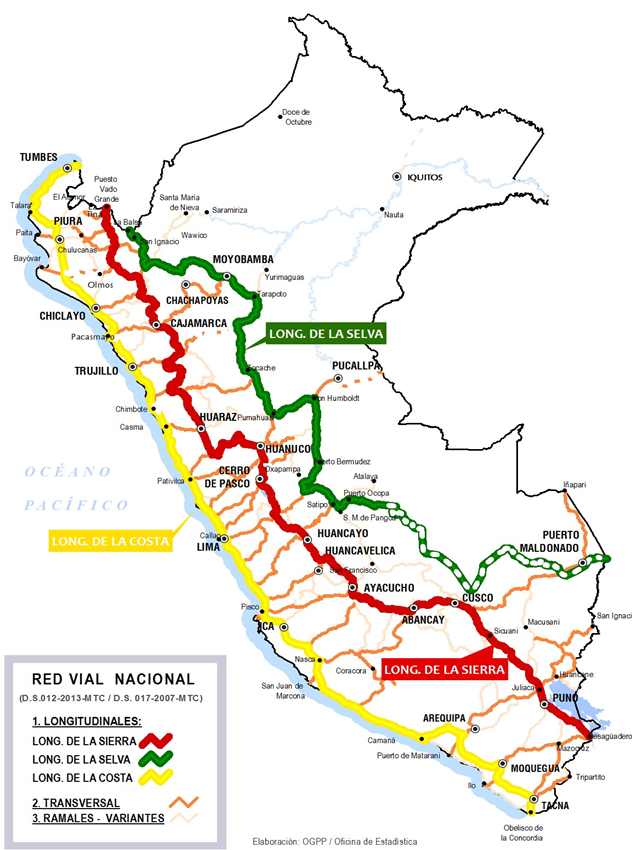
Road Class and Surface Conditions
Road Maps by National Routes: https://portal.mtc.gob.pe/transportes/caminos/normas_carreteras/mapa-ruta-nacional.html
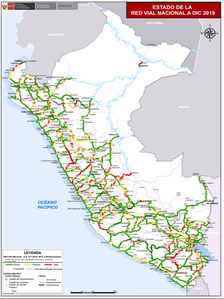
Classification of Roads in Peru:
International Road Network
PAN – Panamerican Highway
INO – Interoceanic Highway
CMS – Marginal Jungle Highway
National Road Network
PE – 1: Longitudinal de la Costa. PE – 1N: Carretera Panamericana Norte. PE – 1S: Carretera Panamericana Sur.
PE – 3 Longitudinal de la Sierra. PE – 3N: Longitudinal de la Sierra Norte. PE – 3S: Longitudinal de la Sierra Sur.
PE – 5: Longitudinal de la Selva – Carretera Marginal de la Selva. PE – 5N: Longitudinal de la Selva Norte. PE – 5S: Longitudinal de la Selva Sur.
National System of Roads (SINAC), which is in charge of ordering the roadways that form part of this organism, in addition to grouping the three types of road networks, based on their functionality and importance, such as:
- National Network Road
- Regional Network Road
- Rural Network Road
For the National Road System, it is responsible for the permanent management, revision, updating and improvement of the same, as well as implementing the norms and instruments for these activities, in addition to defining and officialising the National Register of Carreteras (RENAC). This remains outside the competent authorities such as the MTC.
2.3.1 Peru Border Crossing of Zarumilla (Ecuador)
Overview
The Zarumilla Border Complex (CEBAF) is an immigration control building located in the department of Tumbes, northern Peru. It is located at kilometre 1292 of the Pan-American Highway in the district of Aguas Verdes, province of Zarumilla; it is the obligatory passage for all entry or exit to and from Ecuador using Tumbes as an access road.
The Origin of the CEBAF, came from Decision 502 of the Andean Community of Nations (CAN), signed in Valencia-Venezuela, June 22, 2001, Purpose that the member countries Bolivia, Ecuador, Colombia and Peru, develop a joint action to achieve better use of its physical space, strengthening the infrastructure and services necessary for the economic integration of the sub region.
The CEBAF is the set of facilities that are located in a portion of the territory of one or two adjoining member countries, adjacent to a border crossing, border, which includes the access routes, enclosures, equipment and furniture necessary for the provision of the service of integrated control of the flow of people, people, luggage, luggage, merchandise and vehicles, and where complementary services of facilitation and user care are provided. Integrated control service: The verification and supervision of the legal conditions of entry and exit.
|
Border Crossing Location and Contact |
|
|---|---|
|
Name of Border Crossing |
Peru: Zarumilla |
|
Province or District |
Zarumilla, Tumbes |
|
Nearest Town or City with Distance from Border Crossing |
Tumbes (24.3 km) |
|
Latitude |
-3.482408 |
|
Longitude |
-80.250837 |
|
Managing Authority / Agency |
Superintendencia Nacional de Aduanas y de Administracion Tributaria - SUNAT |
|
Contact Person |
Carlos Rios Sanchez |
|
Travel Times |
|
|---|---|
|
Nearest International Airport |
Talara International Airport (Cap. Victor Montes) Distance in km 205 Truck Travel Time: 2 hours Car Travel time: 1 hour 50 minutes |
|
Nearest Port |
Paita Port (Terminales Portuarios Euroandinos) Distance in km 293.7 Truck Travel Time: 6 hours Car Travel time: 5 hours 40 minutes |
|
Nearest location with functioning wholesale markets, or with significant manufacturing or production capacity |
City of Tumbes Distance in km 21 Truck Travel Time: 30 minutes Car Travel time: 25 minutes |
|
Other Information
|
The authorized border crossing is the place of land connection constituted by the International Bridge of Peace and both countries for the formal entry and exit of people, luggage, merchandise and vehicles. |
|
Hours of Operation |
|
|---|---|
|
Mondays |
24 Hours |
|
Tuesdays |
24 Hours |
|
Wednesdays |
24 Hours |
|
Thursdays |
24 Hours |
|
Fridays |
24 Hours |
|
Saturdays |
24 Hours |
|
Sundays |
24 Hours |
|
National Holidays |
Open all year |
|
Seasonal Constraints |
Mostly during the vacations period in July and December. In addition, rainy season affect sometimes the passing due to the road is interrupted. |
Daily Capacity
Since the CEBAF began to operate, there has been an increase in traffic and passage of vehicles, cars and export and import merchandise, the maximum service capacity of up to 300 vehicles per day, there have been peaks of 2,200 cars per month that have passed through the CEBAF. In passengers, there was a greater influx that is believed to be due to the entry of Venezuelan citizens to Peru, reaching almost 25,000 people in a single month. However, the passenger service capacity is up to 2,000 people per day.
Customs Clearance
SUNAT - the Tumbes Customs Administration in the Tumbes Region, through its Officials Office, represents ADUANAS, it contributes to the prevention of smuggling by preventing and combating customs illicit. It also has a Customs Technique area for the administration and processing of merchandise submitted for the different customs regimes of foreign trade such as Import, Export, Cargo Inspection and Collection. Exports are reaching almost 20 million dollars a month in products that are being exported Dry Coffee in Grains, Ethyl Alcohol, Onions, Fresh Garlic, Eggs, Printing Material (Magazines, Books, Catalogs, etc.). Procedures have been simplified and this has helped to carry out import regularization in less time.
For more information on customs in Peru, please see the following link: 1.3 Customs Information.
Other Relevant Information
The Legal Framework in Peru, Budget Law 2012. The National Superintendence of Customs and Tax Administration (SUNAT) is temporarily entrusted with the administration of the compound of the Binational Border Service Center (CEBAF) Eje Vial 1, Peruvian side, until the creation and implementation of the National Border Control Authority. For this purpose, SUNAT appoints the official in charge of the Management / Coordination of the CEBAF campus, Peruvian side. SUNAT is empowered to exercise all administrative acts that are necessary for the operation of the CEBAF Eje Vial 1 site, which includes the infrastructure, adjacent areas and routes.
The Administrators are in charge of the administrative and operational coordination of the CEBAF in order to facilitate its proper functioning, the conformation of which will be established by bilateral agreement. The officials designated by each member country will provide mutual assistance for the exercise of their respective functions. The Peruvian Entities that provide services in CEBAF are:
- SUNAT CUSTOMS for the administration and processing of the goods submitted for the different customs regimes of foreign trade such as Import, Export etc.,
- ITP SANIPES (INSTITUTO TECNOLOGICO PESQUERO-SANIDAD PESQUERA) Provides sanitary control and surveillance service of hydro biological resources, which enter through the border.
- SENASA Responsible authority in the field of Agricultural Health, Quality of Inputs, Organic Production and Food Safety.
- MIGRATIONS and NATIONAL POLICE OF PERU (P.N.P.) to facilitate and stimulate the administration of the migratory movement.
The two headwaters of CEBAF Eje Vial N ° 1 are located in Peru at 2.5 km from the new International Peace Bridge and, in Ecuador at 1.5 km., Control is provided through the application of all legal provisions, regulatory and administrative and in an integrated and joint manner of both States (Ecuador and Peru).
CEBAF Zarumilla – Tumbes
Carretera Panamericana Norte Km. 1292, Eje Vial No.01
Aguas Verdes - Zarumilla – Tumbes
Administrator Peru: Carlos Rios Sanchez
Tel. +5172-523893 (Switchboard SUNAT)
Cel. +985963808 (Migration Office)
For more information on government contact details, please see the following link: 4.1 Government Contact List.
2.3.2 Peru Border Crossing of Santa Rosa (Chile)
Overview
The Santa Rosa Border Complex is a customs and immigration control building, located in the department or region of Tacna, in the southern part of Peru, close to the Concordia Line that separates Peru with the Republic of Chile. It is similar to the border customs complex on the Chilean side called Chacalluta.
It is located on the South Pan-American Highway (Route - 1S) almost 250 meters from the international border; this complex is an obligatory part of entry or exit from Peru to the Republic of Chile. It has a total area of more than 168,000 square meters. The administration of the Border Complex is under the administration of the National Superintendence of Customs and Tax Administration.
The new facilities were rebuilt in 2007. It has the services of Customs, Ministry of Foreign Trade and Tourism, Ministry of the Interior, Bank of the Nation, National Police as well as other dependencies of the Peruvian State. In October 2008, a module or health post was inaugurated.
|
Border Crossing Location and Contact |
|
|---|---|
|
Name of Border Crossing |
Peru: Santa Rosa Chile: Chacalluta |
|
Province or District |
Tacna |
|
Nearest Town or City with Distance from Border Crossing |
Tacna (41.3 km) |
|
Latitude |
-18.307521 |
|
Longitude |
-70.314313 |
|
Managing Authority / Agency |
Superintendencia Nacional de Aduanas y de Administracion Tributaria - SUNAT |
|
Contact Person |
Santa Rosa Border Complex +5152 – 583120 |
|
Travel Times |
|
|---|---|
|
Nearest International Airport |
Aeropuerto Internacional Carlos Ciriani (Tacna) Distance in km 37.3 Truck Travel Time: 50 minutes Car Travel time: 39 minutes |
|
Nearest Port |
Name Port of Ilo Distance in km 157.7 Truck Travel Time: 3.0 hours Car Travel time: 2.7 hours |
|
Nearest location with functioning wholesale markets, or with significant manufacturing or production capacity |
City of Tacna Distance in km 41.3 Truck Travel Time: 1 hour Car Travel time: 50 minutes |
|
Other Information
|
At the exit of the City of Tacna, there is a very complete gas station, also throughout the city there are other gas stations. This area is desert and it is very hot from January to April. |
|
Hours of Operation |
|
|---|---|
|
Mondays |
08:00 am to 20:00 pm |
|
Tuesdays |
08:00 am to 20:00 pm |
|
Wednesdays |
08:00 am to 20:00 pm |
|
Thursdays |
08:00 am to 20:00 pm |
|
Fridays |
08:00 am to 20:00 pm |
|
Saturdays |
08:00 am to 22:00 pm |
|
Sundays |
08:00 am to 22:00 pm |
|
National Holidays |
01 January, 24 December |
|
Seasonal Constraints |
Winter months (May and June) Spring months (September and October) |
Daily Capacity
Most of the traffic of people and cars that go to Chile and that come from Chile occur on weekends. Almost 25,000 people were received or attended on Saturdays and Sundays. Due to the restrictions of the pandemic, this capacity to attend to citizens who cross the border has been reduced to 50%. There are many people who have relatives in both border cities (Arica and Tacna).
Customs Clearance
Its infrastructure is based on a linear service model duly differentiated according to the transport unit and the user, integrating the entities involved in its operation, optimizing the points of attention in search of the least displacement of users, avoiding congestion and using state-of-the-art technology for the development of control activities. The physical recognition sector has a booth to control the entry of trucks, a scale, an elevated platform for visual control of trucks, and offices for officials of the control agencies. The transport of cargo or goods enter the sector of the internment yard or are quickly dispatched to their destination under the customs transit modality.
For more information on customs in Peru, please see the following link: 1.3 Customs Information.
Other Relevant Information
The public entities that perform functions in the Santa Rosa Border Complex are: the National Superintendence of Tax Administration (SUNAT) through the Santa Rosa Customs Agency (ADUANA), the General Forest and Wildlife Directorate (SERFOR), National Service of Agrarian Health (SENASA), National Superintendence of Migration (MIGRACIONES), National Police of Peru (PNP), Banco de la Nation (BN), and the Ministry of Culture.
The administration of the Border Complex is in charge of SUNAT, through the Santa Rosa Administrative Support Section, whose function is to guarantee its optimal operation, as well as to provide the goods and services necessary for the development of control tasks.
Santa Rosa Border Complex
Main office:
South Pan-American Highway Km. 1336,
Tacna - Peru
Phone: +5152 – 583120
E-mail: jefatura_starosa@sunat.gob.pe
Web: www.complejosantarosa.sunat.gob.pe
For more information on government contact details, please see the following link: 4.1 Government Contact List.
2.3.3 Peru Border Crossing of Desaguadero (Bolivia)
Overview
The new Binational Border Service Center (CEBAF), located in Desaguadero, Bolivia and Peru, seeks to organize and expedite border transit at the main border crossing they share. The new facilities, fully equipped in terms of infrastructure, connectivity and services, allow the safe and orderly transit of passengers, vehicles and cargo 24 hours a day, 365 days a year. Likewise, with the implementation of Integrated Cargo Control, waiting times will be substantially reduced, avoiding congestion and saturation of access roads.
The CEBAF facilities are presented as an intelligent infrastructure for the unified attention of immigration and customs procedures, with buildings for the attention to the public and the administration of the CEBAF, ways to control the transport of cargo, warehouses, electronic scales, scanners, and security perimeter.
The new Center will also have sectors for officials of the National Superintendence of Tax Administration (SUNAT), General Directorate of Migration and Naturalization, National Agricultural Health Service (SENASA), General Directorate of Environmental Health (DIGESA), National Institute of Natural Resources (INRENA), National Police and the Ministry of Transport and Communications, all of them from Peru.
The integrated control will imply a single stop of the flow of people, luggage, vehicles, and cargo passing through the passage, using procedures that will avoid duplication of procedures and records at the entrance and exit. This control will be carried out sequentially, beginning with the procedures of the country of departure and ending with the procedures of the country of entry, intervening the transport and communications, health, police, immigration and customs authorities, in that order.
|
Border Crossing Location and Contact |
|
|---|---|
|
Name of Border Crossing |
Peru: Desaguadero |
|
Province or District |
Puno |
|
Nearest Town or City with Distance from Border Crossing |
Puno (147 km) |
|
Latitude |
-16.563607 |
|
Longitude |
-69.036731 |
|
Managing Authority / Agency |
CEBAF Desaguadero |
|
Contact Person |
Raúl Bravo Revilla Administrator CEBAF Desaguadero (SUNAT) Tel. +511599400 Ext. 47540 Tel. +5151-362616 |
|
Travel Times |
|
|---|---|
|
Nearest International Airport |
Juliaca International Airport (196 km) Truck Travel Time: 4 hours Car Travel time: 3. 30 hours |
|
Nearest Port |
Puerto de Ilo - Moquegua (391 km) Truck Travel Time: 7 hours Car Travel time: 6 hrs |
|
Nearest location with functioning wholesale markets, or with significant manufacturing or production capacity |
City of Puno (147 km) Truck Travel Time: 3 hours Car Travel time: 2.30 hours |
|
Other Information
|
To all this movement also need to be added the local border traffic, which develops an intense commercial activity with different degrees of informality, which consists of the transport of merchandise by means of human traction across the bridge, and in loading and unloading operations truck unloading on both sides of the border. |
|
Hours of Operation |
|
|---|---|
|
Mondays |
09:00 to 21:00 Hours |
|
Tuesdays |
09:00 to 21:00 Hours |
|
Wednesdays |
09:00 to 21:00 Hours |
|
Thursdays |
09:00 to 21:00 Hours |
|
Fridays |
09:00 to 21:00 Hours |
|
Saturdays |
08:00 to 20:00 Hours |
|
Sundays |
08:00 to 20:00 Hours |
|
National Holidays |
CEBAF works 365 days a year |
|
Seasonal Constraints |
In July and December, increase the transit of people and cars. |
Daily Capacity
The Desaguadero border crossing is one of the busiest border points in Peru. In 2018, it was ranked fourth in the country's migratory movement, with around 800,000 registered people. Of this total, 500,000 people were of Peruvian nationality and 300,000 foreigners. These values, which have been more or less constant since 2010, represent the completion of around 2,000 migratory procedures daily, only in terms of the transit of people.
Customs Clearance
The largest traffic through the border customs of Peru occurs through the Desaguadero border crossing, and represents 80.6% of the total traffic of merchandise that crosses the borders land of the country. In 2016, exports from Peru to Bolivia through the Desaguadero border crossing amounted to a FOB value of US $ 325.38 million, which represented 58% of total Peruvian exports to Bolivia for that year (of US $ FOB 562.4 million).
The main ten products mobilized were baby diapers, ethylene polymers, perfumes, yarn fibres, bakery products, cement, silicones, petroleum bitumen, cleaning products and seats. Meanwhile, Bolivian exports to Peru through Desaguadero for the same period amounted to a FOB value of US $ 289.73 million, being the main ten products mobilized: cakes and other soybean milling residues, bean flour, petroleum and gas liquefied, propane gas, beans, milk, oilseeds and crude oil, gold ore, and peanuts.
Almost all shipments have Peruvian territory as their final destination, which can be verified at present with the almost non-existence of Bolivian cargo shipments in the nearby ports of Ilo and Matarani. If the contribution of the Bolivian Department bordering La Paz in the total exports to Peru via Desaguadero is analysed, these reached a FOB value of US $ 18 million in 2016, which represents only 6.21% of the total exported by the pass.
For more information on customs in Peru, please see the following link: 1.3 Customs Information.
Other Relevant Information
This situation reflects the importance that the new CEBAF will acquire to consolidate the important flows of goods that currently exist between the two countries through Desaguadero, whose implementation will speed up and boost the transport of land cargo, improving trade at the regional level. This will not only happen through the improvement of controls and reduction of processing times in transit operations and customs clearance, but also with the possibility of providing attractive conditions for the establishment in the future of a multimodal logistics platform in both associated countries. To the passage and to the flows of export cargo originating in the Departments of the interior of Bolivia that have as their point of departure the Peruvian ports of the region.
The main objectives of CEBAF according to the CAN are:
- Reduce paperwork times in transit and customs clearance operations.
- Facilitate the crossing of export and import information.
- Increase the flow of cargo movements.
- Make foreign trade operations transparent.
- Fight against Smuggling.
- Immediate identification of customs illicit jointly (technical and / or documentary smuggling, ghost exports).
CENTRO BINACIONAL DE ATENCIÓN DE FRONTERA (CEBAF) DESAGUADERO
Carretera 36A Desaguadero – Moquegua 21610
Puno - Perú
Raúl Bravo Revilla
Administrator CEBAF Desaguadero (SUNAT)
Tel. +511599400 Ext. 47540
Tel. +5151-362616
For more information on government contact details, please see the following link: 4.1 Government Contact List.
2.3.4 Peru Border Crossing of Iñapari (Brazil)
Overview
The Iñapari Border Crossing is located in Iñapari, which is one of the three districts of the Province of Tahuamanu, located in the Department of Madre de Dios, Madre de Dios Region, in Peru. The Acre River marks the border between Peru and Brazil. Currently, the entire South Interoceanic highway is paved and the distance of 229 km that separates Iñapari from Puerto Maldonado can be done in a trip of approximately 3 hours by car.
It is also the border, customs control point for entering, and leaving the country on the Interoceanic Highway that links the Pacific Ocean to the Atlantic. This road crosses the border (about 200 meters from the main square of Iñapari) over the Acre River and 1 km further on you reach the Brazilian town of Assis Brasil.
|
Border Crossing Location and Contact |
|
|---|---|
|
Name of Border Crossing |
Peru: Iñapari |
|
Province or District |
Iñapari - Madre de Dios |
|
Nearest Town or City with Distance from Border Crossing |
Puerto Maldonado (229 km) |
|
Latitude |
-10.955271 |
|
Longitude |
-69.577560 |
|
Managing Authority / Agency |
Superintendencia Nacional de Aduanas y de Administracion Tributaria (SUNAT) |
|
Contact Person |
Av. Leon Velarde S/N (Carretera Interoceânica) Barrio La Colonia – Iñapari – Madre de Dios Tel.+51988650657 |
|
Travel Times |
|
|---|---|
|
Nearest International Airport |
Cuzco International Airport (704 km) Truck Travel Time: 13 hours Car Travel time: 12 hours |
|
Nearest Port |
Port of Ilo - Moquegua (1,190 km) Truck Travel Time: 21 hours Car Travel time: 20 hours |
|
Nearest location with functioning wholesale markets, or with significant manufacturing or production capacity |
Puerto Maldonado (229 km) Truck Travel Time: 4:00 hours Car Travel time: 3:30 hours |
|
Other Information |
On the Interoceanic highway from Puerto Maldonado to Iñapari, there are several service stations and several towns are crossed on the route. |
|
Hours of Operation |
|
|---|---|
|
Mondays |
07:00 am to 19:00 pm |
|
Tuesdays |
07:00 am to 19:00 pm |
|
Wednesdays |
07:00 am to 19:00 pm |
|
Thursdays |
07:00 am to 19:00 pm |
|
Fridays |
07:00 am to 19:00 pm |
|
Saturdays |
07:00 am to 19:00 pm |
|
Sundays |
07:00 am to 19:00 pm |
|
National Holidays |
The border crossing is open 365 days a year. |
|
Seasonal Constraints |
No seasonal restrictions |
Daily Capacity
Due to the little traffic of passengers and cargo that cross the border, it is much reduced, also the capacity is reduced. It can handle 200 people a day. However, if they do not have the proper facilities, their create a bottleneck when you have many people trying to cross the border.
Customs Clearance
Import or export cargo crossing is not very common. Unfortunately, there are no trade agreements and free transit across borders, as in the case of Bolivia, Ecuador and Chile. The SUNAT office is implemented but sends all import cargo to its warehouses in Puerto Maldonado, cargo is not cleared at this border. The movement or traffic of passengers is reduced therefore there is not much trade of import or export of goods.
For more information on customs in Peru, please see the following link: 1.3 Customs Information.
Other Relevant Information
The studies for the construction of the Frontier Control Center in Iñapari, whose feasibility has not yet been processed because Brazil believes that it is not convenient, for the time being, to implement an integrated control system as established in the Acuerdo Marco signed by both Chancelleries.
The Peruvian and Brazilian delegations discuss a proposal to move forward in integrated control, through the exchange of information and coordination of procedures among peers. The internalization of the Agreement between Brazil and Peru for the Establishment of Integrated Control Systems at Border Posts is awaited in the legal system in order to proceed with the negotiations regarding the installation of the post.
Border Control currently on the Peru side has a heterogeneous provision of control and facilitation services for the transit of persons, equipment, goods and vehicles on the Paso de Frontera by each of the national border control entities. It is a weak organization of the front. In addition to a deficient infrastructure (provisional) and equipment in the Frontier Control Center.
Complejo Fronterizo Iñapari
Av. Leon Velarde S/N (Carretera Interoceânica)
Barrio La Colonia – Iñapari – Madre de Dios
Tel.+51988650657
For more information on government contact details, please see the following link: 4.1 Government Contact List.