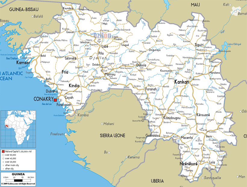
2.3 Guinea Road Network

National roads in Guinea represent 16% of the 44,301 km of the inventoried road network. This network includes prefecture (or secondary) roads - 36%; and community (or tertiary) roads - 48%. The overall state of national roads is very unsatisfactory (paved: good 16%, average 31% and bad 50%; unpaved: good 6%, average 51% and bad 43%). There are different projects that the government intends to launch with the support of development partners. The road plan contains a portfolio of 31 priority projects estimated at 1.12 billion Euros (US $1.54 billion, GNF 10.8 trillion). It covers:
- Construction or rehabilitation of 2,262 km of national roads;
- Construction of 31 km of two-lane roads;
- Rehabilitation of 96 km of national roads;
- Reinforcement of 725 km of national roads;
- Improvement of 3,000 km of roads for prefectures and 4,000 km of community road;
- Construction 620 km of urban roads, including 140 km in Conakry; and
- Installation of five (5) toll-weighing stations.
On 30 June 2015, Africa Finance Corporation (AFC) announced a loan of EUR 30 million to EBOMAF Group for the rehabilitation and paving of a section of 194 km of National Highway 6 (RN 6), connecting Kissidougou and Kankan. Built in the 1970s as part of the Guinea-Cuban cooperation, the stretch of the N6 between Kissidougou and Kankan displays a serious state of deterioration, and high congestion levels and heavy rains will make the transport of persons, freight and livestock extremely difficult.
Sogea-Satom is realizing the rehabilitation of the RN2, a distance of 53 km between Kissidougou and Guéckédou, as well as the reconstruction of ten bridges. The project is worth €55 m and is funded by the European Union (10th EDF program). It will be implemented within 24 months.
The road network in Guinea Republic is composed of 44,301 km as follows:
- National road (RN): 7,576 km of which:
- 2,346 km is paved roads
- 5,230 km is dirt roads
- Prefectural roads: 15,879 km (dirt road)
- Communal roads: 19,846 km (dirt road)
- Urban roads: 1,000 km
On the national and regional roads there are the following crossings:
- Ferries: 24 in good and bad conditions
- Wooden bridges: 5
- Temporary bridges: 31
- Concrete bridges: 1,946
- Metal bridges: 39 (26 renovated)
The national roads are composed of the following itineraries:
- N1: connecting Conakry - Coyah - Kindia - Mamou - Dabola - Kouroussa - Kankan
- N2: connecting Mamou - Faranah - Kissidougou -Guékédou - Macenta - Nzérékoré - Lola. In dry season can reach Yamoussoukro (Côte d'Ivoire)
- N4: connecting Coyah - Forécariah - Farmoreya - towards Sierra Leone
- N5: connecting Mamou - Dalaba - Pita - Labé (Fouta Djalon region) from there, the road is not practicable during the rainy season.
- N6: Connecting Kissidougou - Kankan - Siguiri - Bamako (Mali)
- N20: Connecting Kamsar - Kolaboui - Boké
For information on Guinea Conakry Road Network contact information, please see the following link: 4.1 Guinea Government Contact List
Distance Matrix
For a detailed Distance Matrix, please see the following
attachment: Distances from Capital
City to Major Towns
|
Travel Time from Capital City to Major Towns (days in dry / rainy seasons) |
||||||||
|---|---|---|---|---|---|---|---|---|
|
Conakry |
Boke |
Labe |
Siguiri |
Kankan |
Kissidougou |
Macenta |
Nzerekore |
|
|
Conakry |
1 / 1 |
2 / 2 |
3 / 4 |
3 / 3 |
3 / 3 |
3 / 4 |
4 / 5 |
|
|
Boke |
1 / 1 |
3 / 3 |
2 / 2 |
5 / 5 |
4 / 4 |
5 / 5 |
5 / 5 |
|
|
Labe |
2 / 2 |
3 / 3 |
3 / 3 |
3 / 3 |
2 / 2 |
3 / 3 |
3 / 3 |
|
|
Siguiri |
3 / 4 |
2 / 2 |
3 / 3 |
1 / 1 |
4 / 4 |
4 / 4 |
5 / 5 |
|
|
Kankan |
3 / 3 |
5 / 5 |
3 / 3 |
1 / 1 |
4 / 4 |
4 / 5 |
5 / 5 |
|
|
Kissidougou |
3 / 3 |
4 / 4 |
2 / 2 |
4 / 4 |
4 / 4 |
1 / 1 |
2 / 2 |
|
|
Macenta |
3 / 4 |
5 / 5 |
3 / 3 |
5 / 5 |
4 / 5 |
1 / 1 |
1 / 1 |
|
|
Nzerekore |
4 / 5 |
5 / 5 |
3 / 3 |
5 / 5 |
5 / 5 |
2 / 2 |
1 / 1 |
|
Road Security
The road security is low due to the road conditions and absence of proper regulations and implementation of road safety measures. The roads in general are in bad condition. The absence of speed limits, bad condition of vehicles, drivers without a minimum knowledge of road regulations, no lights during the night and the overloading of trucks are all factors that impact the road security level in the country. In some regions, armed robberies might occur on certain roads. It is advisable not to travel during the night.
Weighbridges and Axle Load Limits
In Guinea, there is one weighbridge at the exit of Kagbelen but it it has been a long time since it was last used since there are no regulations on axle load limits. The overloaded trucks accelerate the deterioration of the roads.
Road Class and Surface Conditions
2.3.1 Guinea Border Crossing of Mandiana
Overview
Mandiana is a town located in eastern Guinea. It is the capital of Mandiana Prefecture. As of 2014 the town and surrounding sub-prefecture had a population of 25,791 people. There are notable gold reserves in the area. It is part of the Birimian rocks, of the Ashanti Gold Belt. It is situated in the Bougouni basin and is underlain by sedimentary rocks of the Upper Birimian Group. The Morila-Syama Gold Belt (known as Morila mine) is located towards the east of the Bougouni basin and is one of the largest gold mines in the area.
|
BORDER CROSSING LOCATION & CONTACT |
|
|---|---|
|
Name of Border Crossing: |
Mandiana [Guinea] Badogo [Mali] |
|
Province or District: |
Kankan / Mandiana |
|
Nearest Town or City:
|
Mandiana 11 km |
|
Latitude: |
11.95103 |
|
Longitude: |
-8.784944 |
|
Managing Authority/Agency: |
Customs Authority |
|
Contact Person |
n/a |
|
Travel Times |
|
|---|---|
|
Nearest International Airport: |
Gbessia International Airport 740 km Truck: 2 days Car: 2 days |
|
Nearest Port: |
Port Autonome of Conakry 750 km Truck: 2 days Car: 2 days |
|
Nearest Major Market:
|
Kankan 137 km Truck: 6 hours Car: 4 hours |
|
Other Information: |
No weighing bridges en route. There is a ferry to cross the river |
|
Hours of Operation |
|
|---|---|
|
MONDAYS |
06:00 – 18:00 |
|
TUESDAYS |
06:00 – 18:00 |
|
WEDNESDAYS |
06:00 – 18:00 |
|
THURSDAYS |
06:00 – 18:00 |
|
FRIDAYS |
06:00 – 18:00 |
|
SATURDAYS |
06:00 – 18:00 |
|
SUNDAYS |
06:00 – 18:00 |
|
NATIONAL HOLIDAYS: |
06:00 – 18:00 |
|
SEASONAL CONSTRAINTS: |
Rainy season |
Daily Capacity
It is a secondary border crossing point. Mainly small trucks of 10 mt use this road.
Customs Clearance
A laissez-passer and ECOWAS vehicle insurance are a must. For humanitarian cargo, all documents should be prepared at the Customs Office in Conakry. Once approved, copies of the documents should be submitted to the regional customs office depending on the point of entry. The Regional Customs Office will mention ‘seen’ on the documents, after that need to transmit the documents to the point of entry.
Other Relevant Information
All trucks are inspected at least once.
For information on border crossing contact information, please see the following link: 4.1 Guinea Government Contact List
2.3.2 Guinea Border Crossing of Kouremale
Overview
The Kankan-Kourémalé-Bamako transnational intercity highway is the single point of entry and exit between Conakry and Bamako. This is the main international border crossing point between the two countries. The road is in good condition.
|
BORDER CROSSING LOCATION & CONTACT |
|
|---|---|
|
Name of Border Crossing: |
Kouremale |
|
Province or District: |
Kankan / Siguiri |
|
Nearest Town or City:
|
Siguiri 81 Km |
|
Latitude: |
11.95678 |
|
Longitude: |
-8.775972 |
|
Managing Authority/Agency: |
Regional Customs Authority of Kankan |
|
Contact Person |
N/A |
|
Travel Times |
|
|---|---|
|
Nearest International Airport: |
Gbessia International Airport 800 km Truck: 2 days Car: 2 days |
|
Nearest Port: |
Port Autonome de Conakry 810 km Truck: 2 days Car: 2 days |
|
Nearest Major Market:
|
Siguiri 81 km Truck: 3 hours Car: 1 hour |
|
Other Information: |
There aren’t any weighing bridges in Guinea, fuel stations can be found along the road. |
|
Hours of Operation |
|
|---|---|
|
MONDAYS |
0800 - 1830 |
|
TUESDAYS |
0800 - 1830 |
|
WEDNESDAYS |
0800 - 1830 |
|
THURSDAYS |
0800 - 1830 |
|
FRIDAYS |
0800 - 1830 |
|
SATURDAYS |
0800 - 1830 |
|
SUNDAYS |
0800 - 1830 |
|
NATIONAL HOLIDAYS: |
0800 - 1830 |
|
SEASONAL CONSTRAINTS: |
Rainy season from May to October may cause some constraints due to bad roads |
Daily Capacity
This is a busy border crossing point which was not closed during the Ebola outbreak in 2014/2015. Private cars are not provided a separate lane.
Customs Clearance
In order to obtain a customs clearance, all the documents should be prepared and approved by the Customs authority in Conakry, then transmitted to the regional customs office respectively. A copy should be made available at the border post by the requester/transporter. The waybill and commercial invoice are the main documents requested by the customs at the border. There are no fees per truck but trucks should have a laissez-passer and insurance card.
Other Relevant Information
An inspection is done on each truck.
For information on border crossing contact information, please see the following link: 4.1 Guinea Government Contact List
2.3.3 Guinea Border Crossing of Foulamory
Overview
Foulamory is a town and sub-prefecture in Gaoual Prefecture, in the Boké Region of northwestern Guinea. As of 2014 it had a population of 10,207 people. There is an old ferry of modest capacity to cross the Koliba river marking the border to Guinea Bissau.
|
BORDER CROSSING LOCATION & CONTACT |
|
|---|---|
|
Name of Border Crossing:
|
Foulamory [Guinea] Piche [Guinea Bissau] |
|
Province or District: |
Boké / Gaoual |
|
Nearest Town or City:
|
Gaoual 88 km |
|
Latitude: |
9.175611 |
|
Longitude: |
-12.96258 |
|
Managing Authority/Agency: |
Customs Authority |
|
Contact Person |
N/A |
|
Travel Times |
|
|---|---|
|
Nearest International Airport: |
Gbessia International Airport 477 km Truck: 10 hours Car: 5 hours |
|
Nearest Port: |
Port Autonome of Conakry 487 km Truck: 10 hours Car: 5 hours |
|
Nearest Major Market:
|
Gaoual 88 km Truck: 3 hours Car: 2 hours |
|
Other Information: |
There is no weighing bridges en-route. Fueling stations could be found in the major towns. |
|
Hours of Operation |
|
|---|---|
|
MONDAYS |
0800 - 1830 |
|
TUESDAYS |
0800 - 1830 |
|
WEDNESDAYS |
0800 - 1830 |
|
THURSDAYS |
0800 - 1830 |
|
FRIDAYS |
0800 - 1830 |
|
SATURDAYS |
0800 - 1830 |
|
SUNDAYS |
0800 - 1830 |
|
NATIONAL HOLIDAYS: |
0800 - 1830 |
|
SEASONAL CONSTRAINTS: |
Rainy season |
Daily
Capacity
The borders were closed during the Ebola outbreak in 2014/2015. Private cars are not provided a separate lane.
Customs Clearance
In order to obtain a customs clearance, all the documents should be prepared and approved by the Customs authority in Conakry, then transmitted to the regional customs office respectively. A copy should be made available at the border post by the requester/transporter. The waybill and commercial invoice are the main documents requested by the customs at the border. There are no fees per truck but trucks should have a laissez-passer and insurance card.
Other Relevant Information
An inspection is done on each truck.
For information on border crossing contact information, please see the following link: 4.1 Guinea Government Contact List
2.3.4 Guinea Border Crossing of Kandika
Overview
The road to this post is not paved and in bad condition, scattered with potholes. For the users of the Labé-Koundara road, they must use the old ferry to cross the Bantala River.
|
BORDER CROSSING LOCATION & CONTACT |
|
|---|---|
|
Name of Border Crossing:
|
Kandika [Guinea] Burunduma [Guinea Bissau] |
|
Province or District: |
Boké / Koundara |
|
Nearest Town or City:
|
Sareboido at 14 km Koundara at 40 km |
|
Managing Authority/Agency: |
Customs Authority |
|
Contact Person |
N/A |
|
Travel Times |
|
|---|---|
|
Nearest International Airport: |
Gbessia International Airport 650 km Truck: 2 days Car: 1 day |
|
Nearest Port: |
Port Autonome of Conakry 660 km Truck: 2 days Car: 1 day |
|
Nearest Major Market:
|
Koundara 40 km Truck: 2 hours Car: 1 hour |
|
Other Information: |
Rainy season |
|
Hours of Operation |
|
|---|---|
|
MONDAYS |
0800 - 1830 |
|
TUESDAYS |
0800 - 1830 |
|
WEDNESDAYS |
0800 - 1830 |
|
THURSDAYS |
0800 - 1830 |
|
FRIDAYS |
0800 - 1830 |
|
SATURDAYS |
0800 - 1830 |
|
SUNDAYS |
0800 - 1830 |
|
NATIONAL HOLIDAYS: |
0800 - 1830 |
|
SEASONAL CONSTRAINTS: |
Rainy season |
Daily Capacity
The borders were closed during the Ebola outbreak in 2014/2015. Private cars are not provided a separate lane.
Customs Clearance
In order to obtain a customs clearance, all the documents should be prepared and approved by the Customs authority in Conakry, then transmitted to the regional customs office respectively. A copy should be made available at the border post by the requester/transporter. The waybill and commercial invoice are the main documents requested by the customs at the border. There are no fees per truck but trucks should have a laissez-passer and insurance card.
Other Relevant Information
An inspection is done on each truck.
For information on border crossing contact information, please see the following link: 4.1 Guinea Government Contact List
2.3.5 Guinea Border Crossing of Sambailo
Overview
Sambailo is a town and sub-prefecture in the Koundara Prefecture in the Boké Region of northern Guinea. As of 2014 it had a population of 15,479 people. There is around 20 km of no man’s land between the two border posts. For the users of the road Labé-Koundara, one must use the old ferry on the Bantala River. This ferry is old and often not in a working condition which delays the crossing.
|
BORDER CROSSING LOCATION & CONTACT |
|
|---|---|
|
Name of Border Crossing
|
Sambailo [Guinea] Diaoube [Senegal] |
|
Province or District |
Boké / Koundara |
|
Nearest Town or City
|
Koundara 12 km |
|
Managing Authority/Agency |
Customs Authority |
|
Contact Person |
N/A |
|
Travel Times |
|
|---|---|
|
Nearest International Airport |
Gbessia International Airport 514 km Truck: 10 hours Car: 8 hours |
|
Nearest Port |
Port Autonom of Conakry 519 km Truck: 10 hours Car: 8 hours |
|
Nearest Major Market
|
Koundara 12 km Truck: 1 hour Car: 1 hour |
|
Other Information |
No weighing bridges en-route. |
|
Hours of Operation |
|
|---|---|
|
MONDAYS |
0800 - 1830 |
|
TUESDAYS |
0800 - 1830 |
|
WEDNESDAYS |
0800 - 1830 |
|
THURSDAYS |
0800 - 1830 |
|
FRIDAYS |
0800 - 1830 |
|
SATURDAYS |
0800 - 1830 |
|
SUNDAYS |
0800 - 1830 |
|
NATIONAL HOLIDAYS |
0800 - 1830 |
|
SEASONAL CONSTRAINTS |
Rainy season |
Daily Capacity
The borders were closed during the Ebola outbreak in 2014/2015. Private cars are not provided a separate lane.
Customs Clearance
In order to obtain a customs clearance, all the documents should be prepared and approved by the Customs authority in Conakry, then transmitted to the regional customs office respectively. A copy should be made available at the border post by the requester/transporter. The waybill and commercial invoice are the main documents requested by the customs at the border. There are no fees per truck but trucks should have a laissez-passer and the insurance card.
Other Relevant Information
An inspection is done on each truck.
For information on border crossing contact information, please see the following link: 4.1 Guinea Government Contact List
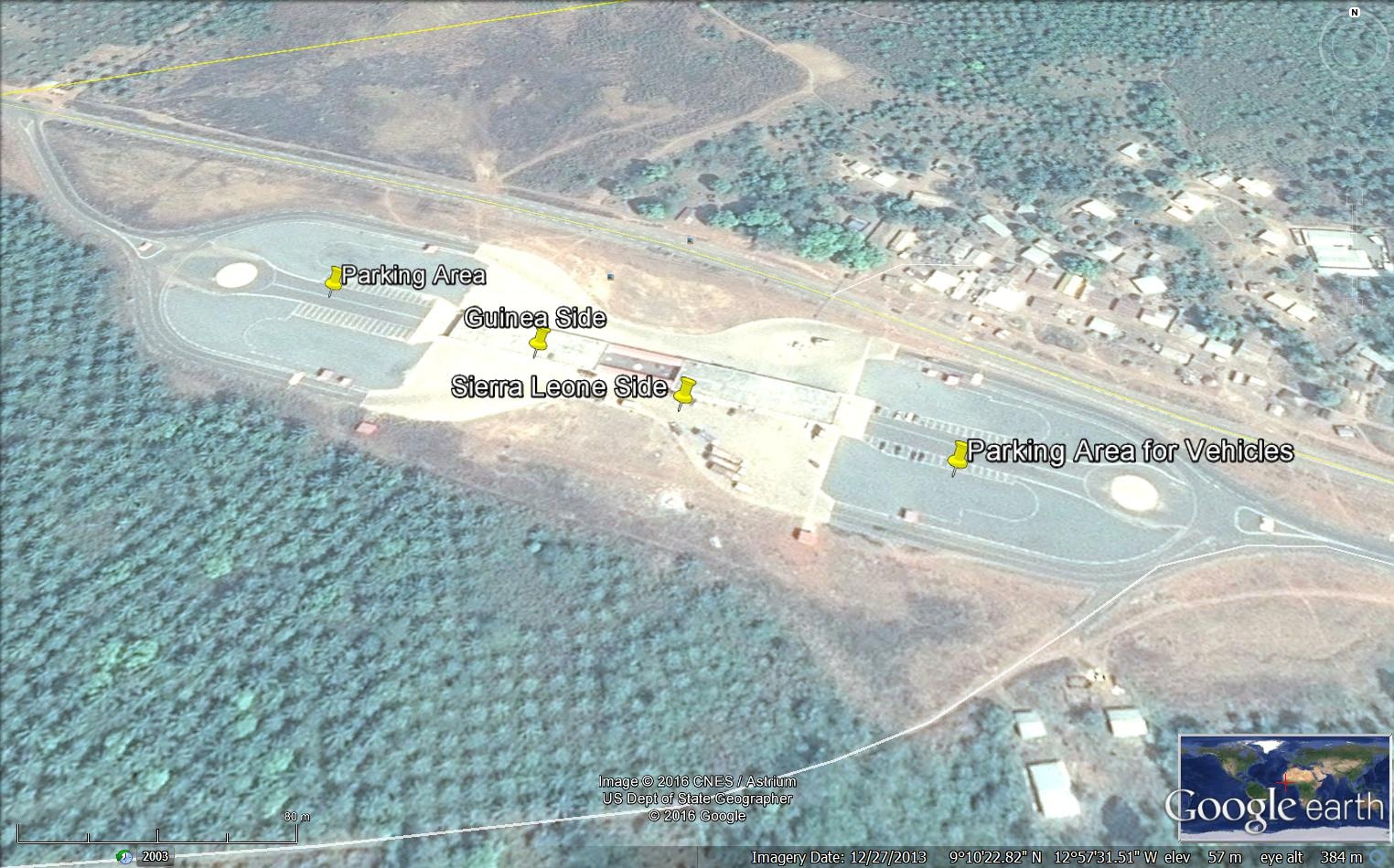
2.3.6 Guinea Border Crossing of Pamalape
Overview
The border authorities of both sides are located in a new building shared between the Guinean and Sierra Leonean authorities. The building was constructed with the support of the EU. There is a large parking area on both sides. The road serving this border point is paved and in good condition from both sides. It is the main border point between the two countries.
|
BORDER CROSSING LOCATION & CONTACT |
|
|---|---|
|
Name of Border Crossing
|
Pamalape [Guinea] Kambia [Sierra Leone] |
|
Province or District |
Forecariah |
|
Nearest Town or City
|
Forecariah 33 km |
|
Managing Authority/Agency |
Customs Authority |
|
Contact Person |
N/A |
|
Travel Times |
|
|---|---|
|
Nearest International Airport |
Conakry Gbessi International Airport 121 km Truck: 3 hours Car: 2 hours |
|
Nearest Port |
Port Autonome de Conakry 131 km Truck: 3 hours Car: 2 hours |
|
Nearest Major Market
|
Forécariah 33 km Truck: 1 hour Car: 1 hour |
|
Other Information |
Fueling stations are available along the road. There are no weighing bridges en-route. |
|
Hours of Operation |
|
|---|---|
|
MONDAYS |
0800 - 1830 |
|
TUESDAYS |
0800 - 1830 |
|
WEDNESDAYS |
0800 - 1830 |
|
THURSDAYS |
0800 - 1830 |
|
FRIDAYS |
0800 - 1830 |
|
SATURDAYS |
0800 - 1830 |
|
SUNDAYS |
0800 - 1830 |
|
NATIONAL HOLIDAYS |
0800 - 1830 |
|
SEASONAL CONSTRAINTS |
Rainy season |
Daily Capacity
The borders were closed during the Ebola outbreak in 2014/2015. Private cars are not provided a separate lane.
Customs Clearance
In order to obtain a customs clearance, all the documents should be prepared and approved by the Customs authority in Conakry, then transmitted to the regional customs office respectively. A copy should be made available at the border post by the requester/transporter. The waybill and commercial invoice are the main documents requested by the customs at the border. There are no fees per truck but trucks should have a laissez-passer and insurance card.
Other Relevant Information
An inspection is done on each truck.
For information on border crossing contact information, please see the following link: 4.1 Guinea Government Contact List
2.3.7 Guinea Border Crossing of Madina Oula
Overview
Madina-Oula is a town and sub-prefecture in the Kindia Prefecture in the Kindia Region of western Guinea. The road from Madina Oula to Kindia is not paved and can deteriorate during the rainy season.
|
BORDER CROSSING LOCATION & CONTACT |
|
|---|---|
|
Name of Border Crossing
|
Madina Oula [Guinea] Saina [Sierra Leone] |
|
Province or District |
Kindia |
|
Nearest Town or City
|
Kindia 65 km |
|
Latitude |
9.880611 |
|
Longitude |
-12.4475 |
|
Managing Authority/Agency |
Customs Authority |
|
Contact Person |
N/A |
|
Travel Times |
|
|---|---|
|
Nearest International Airport |
Conakry International Airport 186 km Truck: 5 hours Car: 3 hours |
|
Nearest Port |
Port Autonome de Conakry 196 km Truck: 5 hours Car: 3 hours |
|
Nearest Major Market
|
Kindia 65 km Truck: 2 hours Car: 1 hour |
|
Other Information |
There are no weighing bridges en-route. Fueling stations are available in nearest towns. |
|
Hours of Operation |
|
|---|---|
|
MONDAYS |
0800 - 1830 |
|
TUESDAYS |
0800 - 1830 |
|
WEDNESDAYS |
0800 - 1830 |
|
THURSDAYS |
0800 - 1830 |
|
FRIDAYS |
0800 - 1830 |
|
SATURDAYS |
0800 - 1830 |
|
SUNDAYS |
0800 - 1830 |
|
NATIONAL HOLIDAYS |
No closing days. |
|
SEASONAL CONSTRAINTS |
Rainy season might make the access to the border difficult and delays might occur. |
Daily Capacity
The borders were closed during the Ebola outbreak in 2014/2015. Private cars are not provided a separate lane.
Customs Clearance
In order to obtain a customs clearance, all the documents should be prepared and approved by the Customs authority in Conakry, then transmitted to the regional customs office respectively. A copy should be made available at the border post by the requester/transporter. The waybill and commercial invoice are the main documents requested by the customs at the border. There are no fees per truck but trucks should have a laissez-passer and insurance card.
Other Relevant Information
An inspection is done on each truck.
For information on border crossing contact information, please see the following link: 4.1 Guinea Government Contact List
2.3.8 Guinea Border Crossing of Zanlenzou
Overview
The road from this border point to Lola is extremely bad. There are no structures for the customs or the border point. Before the Ebola outbreak few trucks of 10 mt or less used this road.
|
BORDER CROSSING LOCATION & CONTACT |
|
|---|---|
|
Name of Border Crossing |
Zanlenzou (Guinea / Ivory Coast) |
|
Province or District |
N’Zérékoré / Lola |
|
Nearest Town or City |
Lola 40 km |
|
Managing Authority/Agency |
Customs Authority |
|
Contact Person |
N/A |
|
Travel Times |
|
|---|---|
|
Nearest International Airport |
N/A |
|
Nearest Port |
N/A |
|
Nearest Major Market
|
Lola 40 km |
|
Other Information |
No fueling stations nor weighing bridges en-route. |
|
Hours of Operation |
|
|---|---|
|
MONDAYS |
0800 - 1830 |
|
TUESDAYS |
0800 - 1830 |
|
WEDNESDAYS |
0800 - 1830 |
|
THURSDAYS |
0800 - 1830 |
|
FRIDAYS |
0800 - 1830 |
|
SATURDAYS |
0800 - 1830 |
|
SUNDAYS |
0800 - 1830 |
|
NATIONAL HOLIDAYS |
0800 - 1830 |
|
SEASONAL CONSTRAINTS |
Rainy season |
Daily Capacity
The border was closed during the Ebola Outbreak in 2014/2015.
For information on border crossing contact information, please see the following link: 4.1 Guinea Government Contact List
2.3.9 Guinea Border Crossing of Nongoa
Overview
There is a ferry to cross the river Moa which separates Guinea and Sierra Leone. The ferry can transport one truck of 15 mt per trip. The road is not paved and during the rainy season and can be deteriorated on both sides.
|
BORDER CROSSING LOCATION & CONTACT |
|
|---|---|
|
Name of Border Crossing |
Nongoa [Guinea] Koidu [Sierra Leone] |
|
Province or District |
N’zérékoré / Guékedou |
|
Nearest Town or City
|
Guékedou 28 km |
|
Latitude |
8.500778 |
|
Longitude |
-10.33192 |
|
Managing Authority/Agency |
Customs Authority |
|
Contact Person |
N/A |
|
Travel Times |
|
|---|---|
|
Nearest International Airport |
Gbessia International Airport 934 km Truck: 2 days Car: 2 days |
|
Nearest Port |
Port Autonome of Conakry 944 km Truck: 2 days Car: 2 days |
|
Nearest Major Market
|
Gueckedou 28 km Truck: 1 hour Car: 1 hour |
|
Other Information |
There is no weighing bridges en-route. Fueling stations are available in the main towns. |
|
Hours of Operation |
|
|---|---|
|
MONDAYS |
0800 - 1830 |
|
TUESDAYS |
0800 - 1830 |
|
WEDNESDAYS |
0800 - 1830 |
|
THURSDAYS |
0800 - 1830 |
|
FRIDAYS |
0800 - 1830 |
|
SATURDAYS |
0800 - 1830 |
|
SUNDAYS |
0800 - 1830 |
|
NATIONAL HOLIDAYS |
0800 - 1830 |
|
SEASONAL CONSTRAINTS |
Rainy season |
Daily Capacity
The borders were closed during the Ebola outbreak in 2014/2015. Private cars are not provided a separate lane.
Customs Clearance
In order to obtain a customs clearance, all the documents should be prepared and approved by the Customs authority in Conakry, then transmitted to the regional customs office respectively. A copy should be made available at the border post by the requester/transporter. The waybill and commercial invoice are the main documents requested by the customs at the border. There are no fees per truck but trucks should have a laissez-passer and the insurance card.
Other Relevant Information
An inspection is done on each truck.
For information on border crossing contact information, please see the following link: 4.1 Guinea Government Contact List
2.3.10 Guinea Border Crossing of Bossou
Overview
Bossou is a town and sub-prefecture in the Lola Prefecture in the Nzérékoré Region of south-eastern Guinea. Much of the sub prefecture consists of the Mount Nimba Strict Nature Reserve. The road to Nzerekoré is not paved and during the rainy season it becomes difficult to access.
|
BORDER CROSSING LOCATION & CONTACT |
|
|---|---|
|
Name of Border Crossing
|
Bossou [Guinea] Yekepa [Liberia] |
|
Province or District |
N’zérékoré / Lola |
|
Nearest Town or City
|
Lola 20 km |
|
Managing Authority/Agency |
Customs Authority |
|
Contact Person |
N/A |
|
Travel Times |
|
|---|---|
|
Nearest International Airport |
Gbessia International Airport 1,041 km Truck: 3 days Car: 2 days |
|
Nearest Port |
Port Autonome of Conakry 1,050 km Truck: 3 days Car: 2 days |
|
Nearest Major Market
|
Nzerekoré 60 km Truck: 2 hours Car: 1 hour |
|
Other Information |
There is no weighing bridges en-route. Fueling stations are available in the main cities and towns. |
|
Hours of Operation |
|
|---|---|
|
MONDAYS |
0800 - 1830 |
|
TUESDAYS |
0800 - 1830 |
|
WEDNESDAYS |
0800 - 1830 |
|
THURSDAYS |
0800 - 1830 |
|
FRIDAYS |
0800 - 1830 |
|
SATURDAYS |
0800 - 1830 |
|
SUNDAYS |
0800 - 1830 |
|
NATIONAL HOLIDAYS |
0800 - 1830 |
|
SEASONAL CONSTRAINTS |
Rainy season |
Daily Capacity
The borders were closed during the Ebola outbreak in 2014/2015. Private cars are not provided a separate lane.
Customs Clearance
In order to obtain a customs clearance, all the documents should be prepared and approved by the Customs authority in Conakry, then transmitted to the regional customs office respectively. A copy should be made available at the border post by the requester/transporter. The waybill and commercial invoice are the main documents requested by the customs at the border. There are no fees per truck but trucks should have a laissez-passer and the insurance card.
Other Relevant Information
An inspection is done on each truck.
For information on border crossing contact information, please see the following link: 4.1 Guinea Government Contact List
2.3.11 Guinea Border Crossing of Koyama
Overview
Koyamah is a town and sub-prefecture in the Macenta Prefecture in the Nzérékoré Region of south-eastern Guinea.
|
BORDER CROSSING LOCATION & CONTACT |
|
|---|---|
|
Name of Border Crossing
|
Koyamah [Guinea] Zarzor [Liberia] |
|
Province or District |
N’zérékoré / Macenta |
|
Nearest Town or City
|
Macenta 112 km |
|
Latitude |
8.492139 |
|
Longitude |
-9.648861 |
|
Managing Authority/Agency |
Customs Authority |
|
Contact Person |
N/A |
|
Travel Times |
|
|---|---|
|
Nearest International Airport |
Gbessia International Airport 1,015 km Truck: 3 days Car: 2 days |
|
Nearest Port |
Port Autonme de Conakry 1,020 km Truck: 3 days Car: 2 days |
|
Nearest Major Market
|
Nzerekore 95 km Truck: 3 hours Car: 2 hours |
|
Other Information |
There are no weighing bridges en-route. Fueling stations are available in the main towns and cities. |
|
Hours of Operation |
|
|---|---|
|
MONDAYS |
0800 - 1830 |
|
TUESDAYS |
0800 - 1830 |
|
WEDNESDAYS |
0800 - 1830 |
|
THURSDAYS |
0800 - 1830 |
|
FRIDAYS |
0800 - 1830 |
|
SATURDAYS |
0800 - 1830 |
|
SUNDAYS |
0800 - 1830 |
|
NATIONAL HOLIDAYS |
0800 - 1830 |
|
SEASONAL CONSTRAINTS |
Rainy season |
Daily Capacity
The borders were closed during the Ebola outbreak in 2014/2015. Private cars are not provided a separate lane.
Customs Clearance
In order to obtain a customs clearance, all the documents should be prepared and approved by the Customs authority in Conakry, then transmitted to the regional customs office respectively. A copy should be made available at the border post by the requester/transporter. The waybill and commercial invoice are the main documents requested by the customs at the border. There are no fees per truck but trucks should have a laissez-passer and insurance card.
Other Relevant Information
An inspection is done on each truck.
For information on border crossing contact information, please see the following link: 4.1 Guinea Government Contact List
2.3.12 Guinea Border Crossing of Diecke
Overview
Diéké, Djécké or Diecke is a town and sub-prefecture in the Yomou Prefecture in the Nzérékoré Region of south-eastern Guinea. The road to Nzérékoré is not paved and can be difficult during the rainy season. There is small bridge to cross to reach Ganta in Liberia. The road from Ganta to Monrovia is paved and in excellent condition.
|
BORDER CROSSING LOCATION & CONTACT |
|
|---|---|
|
Name of Border Crossing
|
Diecke [Guinea] Ganta [Liberia] |
|
Province or District |
N’zérékoré / Yomou |
|
Nearest Town or City
|
Diecke 15 km |
|
Latitude |
9.378667 |
|
Longitude |
-7.863778 |
|
Managing Authority/Agency |
Customs Authority |
|
Contact Person |
N/A |
|
Travel Times |
|
|---|---|
|
Nearest International Airport |
Gbessia International Airport 1,100 km Truck: 3 days Car: 2 days |
|
Nearest Port |
Port Autonome of Conakry 1,110 km Truck: 3 days Car: 2 days |
|
Nearest Major Market
|
Yomou 63 km Truck: 4 hours Car: 2 hours |
|
Other Information |
No weighing bridges en-route nor fueling stations in the Guinean side. |
|
Hours of Operation |
|
|---|---|
|
MONDAYS |
0800 - 1830 |
|
TUESDAYS |
0800 - 1830 |
|
WEDNESDAYS |
0800 - 1830 |
|
THURSDAYS |
0800 - 1830 |
|
FRIDAYS |
0800 - 1830 |
|
SATURDAYS |
0800 - 1830 |
|
SUNDAYS |
0800 - 1830 |
|
NATIONAL HOLIDAYS
|
0800 - 1830 |
|
SEASONAL CONSTRAINTS
|
Rainy season |
Daily Capacity
The borders were closed during the Ebola outbreak in 2014/2015. Private cars are not provided a separate lane.
Customs Clearance
In order to obtain a customs clearance, all the documents should be prepared and approved by the Customs authority in Conakry, then transmitted to the regional customs office respectively. A copy should be made available at the border post by the requester/transporter. The waybill and commercial invoice are the main documents requested by the customs at the border. There are no fees per truck but trucks should have a laissez-passer and the insurance card.
Other Relevant Information
An inspection is done on each truck.
For information on border crossing contact information, please see the following link: 4.1 Guinea Government Contact List
2.3.13 Guinea Border Crossing of N’zoo
Overview
N'Zoo or Nzo is a town and sub-prefecture in the Lola Prefecture in the Nzérékoré Region of south-eastern Guinea. It is situated at a few kilometers from the Mount Nimba Strict Nature Reserve. It is served by the NR 2 but the section from Lola to this border is badly maintained and is not paved. During the rainy season some potholes might make it difficult to cross. From the Ivoirian side, it is NR A8.
|
BORDER CROSSING LOCATION & CONTACT |
|
|---|---|
|
Name of Border Crossing
|
N’zo [Guinea] Gbapleu [Ivory Coast] |
|
Province or District |
N’zérékoré / Lola |
|
Nearest Town or City
|
Lola 33 km |
|
Managing Authority/Agency |
Customs Authority |
|
Contact Person |
N/A |
|
Travel Times |
|
|---|---|
|
Nearest International Airport |
Gbessia International Airport 1,055 km Truck: 3 days Car: 2 days |
|
Nearest Port |
Port Autonom of Conakry 1,065 km Truck: 3 days Car: 2 days |
|
Nearest Major Market
|
Lola 33 km Truck: 4 hours Car: 2 hours |
|
Other Information
|
No weighing bridges en route nor fueling stations. |
|
Hours of Operation |
|
|---|---|
|
MONDAYS |
0800 - 1830 |
|
TUESDAYS |
0800 - 1830 |
|
WEDNESDAYS |
0800 - 1830 |
|
THURSDAYS |
0800 - 1830 |
|
FRIDAYS |
0800 - 1830 |
|
SATURDAYS |
0800 - 1830 |
|
SUNDAYS |
0800 - 1830 |
|
NATIONAL HOLIDAYS |
0800 - 1830 |
|
SEASONAL CONSTRAINTS |
Rainy season |
Daily Capacity
The borders were closed during the Ebola outbreak in 2014/2015. Private cars are not provided a separate lane.
Customs Clearance
In order to obtain a customs clearance, all the documents should be prepared and approved by the Customs authority in Conakry, then transmitted to the regional customs office respectively. A copy should be made available at the border post by the requester/transporter. The waybill and commercial invoice are the main documents requested by the customs at the border. There are no fees per truck but trucks should have a laissez-passer and the insurance card.
Other Relevant Information
An inspection is done on each truck.
For information on border crossing contact information, please see the following link: 4.1 Guinea Government Contact List
2.3.14 Guinea Border Crossing of Sirana
Overview
|
BORDER CROSSING LOCATION & CONTACT |
|
|---|---|
|
Name of Border Crossing
|
Sirana de Beyla [Guinea] Sirana de Odienne [Ivory Coast] |
|
Province or District |
Nzerekore / Beyla |
|
Nearest Town or City
|
Beyla 148 km |
|
Managing Authority/Agency |
Customs Authority |
|
Contact Person |
N/A |
|
Travel Times |
|
|---|---|
|
Nearest International Airport |
Gbessia International Airport 940 km Truck: 2 days Car: 2 days |
|
Nearest Port |
Port Autonome de Conakry 950 km Truck: 2 days Car: 2 days |
|
Nearest Major Market
|
Nzerekoré 260 km Truck: 1 day Car: 6 hours |
|
Other Information |
No weighing bridges en-route nor fueling stations. |
|
Hours of Operation |
|
|---|---|
|
MONDAYS |
0800 - 1830 |
|
TUESDAYS |
0800 - 1830 |
|
WEDNESDAYS |
0800 - 1830 |
|
THURSDAYS |
0800 - 1830 |
|
FRIDAYS |
0800 - 1830 |
|
SATURDAYS |
0800 - 1830 |
|
SUNDAYS |
0800 - 1830 |
|
NATIONAL HOLIDAYS |
0800 - 1830 |
|
SEASONAL CONSTRAINTS |
Rainy season |
Daily Capacity
The borders were closed during the Ebola outbreak in 2014/2015. Private cars are not provided a separate lane.
Customs Clearance
In order to obtain a customs clearance, all the documents should be prepared and approved by the Customs authority in Conakry, then transmitted to the regional customs office respectively. A copy should be made available at the border post by the requester/transporter. The waybill and commercial invoice are the main documents requested by the customs at the border. There are no fees per truck but trucks should have a laissez-passer and the insurance card.
Other Relevant Information
An inspection is done on each truck.
For information on border crossing contact information, please see the following link: 4.1 Guinea Government Contact List
2.3.15 Guinea Border Crossing of Tinkoro
Overview
|
BORDER CROSSING LOCATION & CONTACT |
|
|---|---|
|
Name of Border Crossing
|
Tinkoro [Guinea] Masala [Ivory Coast] |
|
Province or District |
Nzérékoré / Beyla |
|
Nearest Town or City
|
Beyla 101 km |
|
Latitude |
8.818067 |
|
Longitude |
-7.994322 |
|
Managing Authority/Agency |
Customs Authority |
|
Contact Person |
N/A |
|
Travel Times |
|
|---|---|
|
Nearest International Airport |
Gbessia International Airport 944 km Truck: 2 days Car: 2 days |
|
Nearest Port |
Port Autonome of Conakry 954 km Truck: 2 days Car: 2 days |
|
Nearest Major Market
|
Nzerekoré 217 km Truck: 6 hours Car: 4 hours |
|
Other Information |
There is no weighing bridges en-route. Fueling stations are available near the major towns and cities. |
|
Hours of Operation |
|
|---|---|
|
MONDAYS |
0800 - 1830 |
|
TUESDAYS |
0800 - 1830 |
|
WEDNESDAYS |
0800 - 1830 |
|
THURSDAYS |
0800 - 1830 |
|
FRIDAYS |
0800 - 1830 |
|
SATURDAYS |
0800 - 1830 |
|
SUNDAYS |
0800 - 1830 |
|
NATIONAL HOLIDAYS |
0800 - 1830 |
|
SEASONAL CONSTRAINTS |
Rainy season |
Daily Capacity
The borders were closed during the Ebola outbreak in 2014/2015. Private cars are not provided a separate lane.
Customs Clearance
In order to obtain a customs clearance, all the documents should be prepared and approved by the Customs authority in Conakry, then transmitted to the regional customs office respectively. A copy should be made available at the border post by the requester/transporter. The waybill and commercial invoice are the main documents requested by the customs at the border. There are no fees per truck but trucks should have a laissez-passer and insurance card.
Other Relevant Information
An inspection is done on each truck.
For information on border crossing contact information, please see the following link: 4.1 Guinea Government Contact List
2.3.16 Guinea Border Crossing of Heremakonon
Overview
Hérémakonon is a town and sub-prefecture in the Faranah Prefecture in the Faranah Region of Guinea. As of 2014 it had a population of 12,890 people. The road is not paved and it is very difficult to access during the rainy season.
|
BORDER CROSSING LOCATION & CONTACT |
|
|---|---|
|
Name of Border Crossing
|
Heremakonon [Guinea] Gberia Fotombu [Sierra Leone] |
|
Province or District |
Nzerekore / Faranah |
|
Nearest Town or City
|
Faranah 44 km |
|
Latitude |
9.718564 |
|
Longitude |
-11.00049 |
|
Managing Authority/Agency |
Customs Authority |
|
Contact Person |
N/A |
|
Travel Times |
|
|---|---|
|
Nearest International Airport |
Gbessia International Airport 420 km Truck: 8 hours Car: 6 hours |
|
Nearest Port |
Port Autonome of Conakry 430 km Truck: 8 hours Car: 6 hours |
|
Nearest Major Market
|
Faranah 44 km Truck: 2 hours Car: 1 hour |
|
Other Information |
There are no weighing bridges en-route. |
|
Hours of Operation |
|
|---|---|
|
MONDAYS |
0800 - 1830 |
|
TUESDAYS |
0800 - 1830 |
|
WEDNESDAYS |
0800 - 1830 |
|
THURSDAYS |
0800 - 1830 |
|
FRIDAYS |
0800 - 1830 |
|
SATURDAYS |
0800 - 1830 |
|
SUNDAYS |
0800 - 1830 |
|
NATIONAL HOLIDAYS |
0800 - 1830 |
|
SEASONAL CONSTRAINTS |
Rainy season |
Daily Capacity
The borders were closed during the Ebola outbreak in 2014/2015. Private cars are not provided a separate lane.
Customs Clearance
In order to obtain a customs clearance, all the documents should be prepared and approved by the Customs authority in Conakry, then transmitted to the regional customs office respectively. A copy should be made available at the border post by the requester/transporter. The waybill and commercial invoice are the main documents requested by the customs at the border. There are no fees per truck but trucks should have a laissez-passer and insurance card.
Other Relevant Information
An inspection is done on each truck.
For information on border crossing contact information, please see the following link: 4.1 Guinea Government Contact List
2.3.17 Guinea Border Crossing of Tounkarata
Overview
Tounkarata is a sub-prefecture in the Lola Prefecture in the Nzérékoré Region of south-eastern Guinea. The road is not paved; therefore the border crossing is difficult to access during the rainy season.
|
BORDER CROSSING LOCATION & CONTACT |
|
|---|---|
|
Name of Border Crossing
|
Tounkarata [Guinea] Gbapleu [Ivory Coast] |
|
Province or District |
Nzerekore / Lola |
|
Nearest Town or City
|
Lola 42 km |
|
Latitude |
7.610711 |
|
Longitude |
-8.310711 |
|
Managing Authority/Agency |
Customs Authority |
|
Contact Person |
N/A |
|
Travel Times |
|
|---|---|
|
Nearest International Airport |
Gbessia International Airport 1,064 km Truck: 2 days Car: 1 and half day |
|
Nearest Port |
Port Autonome of Conakry 1,074 km Truck: 2 days Car: 1 and half day |
|
Nearest Major Market
|
Nzérékoré 82 km Truck: 4 hours Car: 2 hours |
|
Other Information
|
There are no weighing bridges en-route. Fueling stations are available along the road. |
|
Hours of Operation |
|
|---|---|
|
MONDAYS |
0800 - 1830 |
|
TUESDAYS |
0800 - 1830 |
|
WEDNESDAYS |
0800 - 1830 |
|
THURSDAYS |
0800 - 1830 |
|
FRIDAYS |
0800 - 1830 |
|
SATURDAYS |
0800 - 1830 |
|
SUNDAYS |
0800 - 1830 |
|
NATIONAL HOLIDAYS |
0800 - 1830 |
|
SEASONAL CONSTRAINTS |
Rainy season |
Daily Capacity
The borders were closed during the Ebola outbreak in 2014/2015. Private cars are not provided a separate lane.
Customs Clearance
In order to obtain a customs clearance, all the documents should be prepared and approved by the Customs authority in Conakry, then transmitted to the regional customs office respectively. A copy should be made available at the border post by the requester/transporter. The waybill and commercial invoice are the main documents requested by the customs at the border. There are no fees per truck but trucks should have a laissez-passer and insurance card.
Other Relevant Information
An inspection is done on each truck.
For information on border crossing contact information, please see the following link: 4.1 Guinea Government Contact List
2.3.18 Guinea Border Crossing of Koundou
Overview
Koundou is a town and sub-prefecture in the Guéckédou Prefecture in the Nzérékoré Region of south-western Guinea. The road is not paved and during the rainy season it can deteriorate greatly.
|
BORDER CROSSING LOCATION & CONTACT |
|
|---|---|
|
Name of Border Crossing
|
Koundou [Guinea] Koidu [Sierra Leone] |
|
Province or District |
N’zérékoré / Guékedou |
|
Nearest Town or City
|
Koundou 7 km |
|
Latitude |
8.670889 |
|
Longitude |
-10.46525 |
|
Managing Authority/Agency |
Customs Authority |
|
Contact Person |
N/A |
|
Travel Times |
|
|---|---|
|
Nearest International Airport |
Gbessia International Airport 674(km Truck: 14 hours Car: 10 hours |
|
Nearest Port |
Port Autonome of Conakry 684 km Truck: 14 hours Car: 10 hours |
|
Nearest Major Market
|
Gueckedou 51 km Truck: 2 hours Car: 1 hour |
|
Other Information
|
There are no weighing bridges en-route. Fueling stations are available in Guéckedou. |
|
Hours of Operation |
|
|---|---|
|
MONDAYS |
0800 - 1830 |
|
TUESDAYS |
0800 - 1830 |
|
WEDNESDAYS |
0800 - 1830 |
|
THURSDAYS |
0800 - 1830 |
|
FRIDAYS |
0800 - 1830 |
|
SATURDAYS |
0800 - 1830 |
|
SUNDAYS |
0800 - 1830 |
|
NATIONAL HOLIDAYS |
0800 - 1830 |
|
SEASONAL CONSTRAINTS |
Rainy season |
Daily Capacity
The borders were closed during the Ebola outbreak in 2014/2015. Private cars are not provided a separate lane.
Customs Clearance
In order to obtain a customs clearance, all the documents should be prepared and approved by the Customs authority in Conakry, then transmitted to the regional customs office respectively. A copy should be made available at the border post by the requester/transporter. The waybill and commercial invoice are the main documents requested by the customs at the border. There are no fees per truck but trucks should have a laissez-passer and insurance card.
Other Relevant Information
An inspection is done on each truck.
For information on border crossing contact information, please see the following link: 4.1 Guinea Government Contact List