

The country’s road network is in an extremely bad state of repair following years of armed conflicts. In theory, the road network comprises 58,358 km of national roads, 86,615 km of rural roads, and 7,400 km of urban roads.
According to estimates, only 5 per cent of the 58,000 km of the national roads are sealed. These sections are mainly located on the axis between Matadi and Kinshasa, Lubumbashi and the Zambian border and some sections in the eastern part of the country. (Source: Ministère des Transports et Voies de Communication Cellule d’Exécution du Projet de Transport Multimodal Report Annuel 2011)
Although there is little reliable detailed information, a large proportion of the road network is known to be in need of repairs. The two main highways on the national road network are the East-West road (linking the port of Matadi to Lubumbashi via Kinshasa) and the North-South road (linking Lubumbashi to Goma, Bukavu and Kisangani).
Recent road quality indicators suggest that the state of the country’s limited paved network (fewer than 3,000 km) has improved considerably and is now comparable with those of other low income countries in the region. (Source: African Development Bank Group)
4.1 Democratic Republic of Congo Government Contact List
Distance Matrix
|
Distances from Capital City to Major Towns (km) |
|||||||||||
|---|---|---|---|---|---|---|---|---|---|---|---|
|
KINSHASA |
MATADI |
BANDUNDU |
KANANGA |
MBUJI MAYI |
LUBUMBASHI |
KINDU |
BUKAVU |
GOMA |
KISANGANI |
MBANDAKA |
|
|
KINSHASA |
355 |
490 |
1,105 |
1,283 |
2,317 |
2,033 |
2,660 |
2,709 |
2,624 |
3,192 |
|
|
MATADI |
355 |
1,051 |
1,460 |
1,638 |
2,672 |
2,388 |
3,015 |
3,064 |
2,979 |
3,547 |
|
|
BANDUNDU |
490 |
1,051 |
973 |
1,151 |
2,184 |
1,901 |
2,528 |
2,577 |
2,492 |
3,059 |
|
|
KANANGA |
1,105 |
1,460 |
973 |
179 |
1,212 |
928 |
1,556 |
1,604 |
1,520 |
2,087 |
|
|
MBUJI MAYI |
1,283 |
1,638 |
1,151 |
179 |
1,036 |
752 |
1,379 |
1,428 |
1,344 |
1,911 |
|
|
LUBUMBASHI |
2,317 |
2,672 |
2,184 |
1,212 |
1,036 |
1,421 |
1,432 |
1,655 |
2,013 |
2,831 |
|
|
KINDU |
2,033 |
2,388 |
1,901 |
928 |
752 |
1,421 |
627 |
841 |
591 |
1,878 |
|
|
BUKAVU |
2,660 |
3,015 |
2,528 |
1,556 |
1,379 |
1,432 |
627 |
|
220 |
647 |
2,028 |
|
GOMA |
2,709 |
3,064 |
2,577 |
1,604 |
1,428 |
1,655 |
841 |
220 |
|
856 |
2,237 |
|
KISANGANI |
2,624 |
2,979 |
2,492 |
1,520 |
1,344 |
2,013 |
591 |
647 |
856 |
|
1,577 |
|
MBANDAKA |
3,192 |
3,547 |
3,059 |
2,087 |
1,911 |
2,831 |
1,878 |
2,028 |
2,237 |
1,577 |
|
Road Security
DRC's territory is partially enclosed. Almost all the provincial capitals can only be reached by air. The national road network is approximately 152,400 km long--only 2% of which is sealed--is in a state of disrepair. Of the priority roads (covering 30,786 km), 25% of which are in good condition, 16% in fair condition and 59% in poor condition.
Out of the 86,821 km of local roads, only 11% are in good condition. (Source: RDC - 2011-2015 - Document de stratégie de réduction de la pauvreté P. 64). There are also roads with checkpoints manned by DRC security forces, which sometimes set up temporary roadblocks, especially at night.
Vehicles are often searched for weapons and valuables and travelers are checked for identity papers. All forms of public transportation are unregulated. Taxis, mini-buses and trains are in poor mechanical condition and are often filled beyond capacity.
Weighbridges and Axle Load Limits
Axle load limit in DRC is derived from the Arrêté Interministériel Instituant des Mesures de Protection du Patrimoine Routier National de 2011.
|
Axle load limits |
LCA Country |
Transit Country |
Transit Country |
|---|---|---|---|
|
Truck with 2 axles |
21 tons |
16,000 kg |
18,000 kg |
|
Truck with 3 axles |
27 tons |
22,000 kg |
24,000 kg |
|
Truck with 4 axles |
50 tons |
26,000 kg |
28,000 kg |
|
Semi-trailer with 3 axles |
50 tons |
26,000 kg |
28,000 kg |
|
Semi-trailer with 4 axles |
50 tons |
34,000 kg |
36,000 kg |
|
Semi-trailer with 5 axles |
50 tons |
40,000 kg |
44,000 kg |
|
Semi-trailer with 6 axles |
50 tons |
46,000 kg |
50,000 kg |
|
Truck & drawbar trailer with 4 axles |
50 tons |
34,000 kg |
37,000 kg |
|
Truck & drawbar trailer with 5 axles |
50 tons |
40,000 kg |
45,000 kg |
|
Truck & drawbar trailer with 6 axles |
50 tons |
46,000 kg |
53,000 kg |
|
Truck & drawbar trailer with 7 axles |
50 tons |
n/a |
56,000 kg |
Road Class and Surface Conditions
There are several classifications of roads in DRC.
As per the official classification, roads are divided into four distinct categories which are managed by various Governmental bodies.
- National Roads
- Priority regional roads
- Secondary regional roads
- Local roads
The National roads, including Priority and Secondary roads, are managed by Office des Routes (OdR).
Local roads are managed by the Direction des voies de Desserte Agricole (DVDA).
The Office des Voiries et Drainage is in charge of all urban roads comprise of sealed and paved roads.
|
Classification |
Road Description |
|---|---|
|
National road (Bitumen-Gravel) |
All paved and dirt roads intended to be paved on major international routes and on major national routes. These roads are part of the public domain of the State and are managed by Office des Routes |
|
Priority Regional road (Sand / Dirt – Gravel) |
They are public domain of the Province and are also managed by Office des Routes |
|
Secondary Regional Road (Sand / Dirt – Gravel) |
They are public domain of the Province and are also managed by Office des Routes |
|
Local road (Sand / Dirt – Gravel) |
They are public domain of the Province and are managed by the Direction des Voies de Desserte Agricole |
Road Inventory
The road network is organized as a network of national roads and each province maintains a network of provincial roads. The provincial roads are divided into a network of priority and secondary roads.
|
National road (RN) (Bas Congo) |
Office des Routes |
1,370 km |
|---|---|---|
|
Priority provincial road (RP1) (Bas Congo) |
Office des Routes |
891 km |
|
Secondary provincial road (RP2) (Bas Congo) |
Office des Routes |
869 km |
|
National road (RN) (Bandundu) |
Office des Routes |
2,177 km |
|
Priority provincial road (RP1) (Bandundu) |
Office des Routes |
3,505 km |
|
Secondary provincial road (RP2) (Bandundu) |
Office des Routes |
3,160 km |
|
National road (RN) (Equateur) |
Office des Routes |
2,939 km |
|
Priority provincial road (RP1) (Equateur) |
Office des Routes |
2,707 km |
|
Secondary provincial road (RP2) (Equateur) |
Office des Routes |
3,158 km |
|
National road (RN) (Prov. Orientale) |
Office des Routes |
3,612 km |
|
Priority provincial road (RP1) (Prov. Orientale) |
Office des Routes |
3,578 km |
|
Secondary provincial road (RP2) (Prov. Orientale) |
Office des Routes |
3,075 km |
|
National road (RN) (South Kivu) |
Office des Routes |
1,023 km |
|
Priority provincial road (RP1) (South Kivu) |
Office des Routes |
873 km |
|
Secondary provincial road (RP2) (South Kivu) |
Office des Routes |
0 km |
|
National road (RN) (Katanga) |
Office des Routes |
4,064 km |
|
Priority provincial road (RP1) (Katanga) |
Office des Routes |
4,024 km |
|
Secondary provincial road (RP2) (Katanga) |
Office des Routes |
2,958 km |
|
National road (RN) (Kasaï Occidental) |
Office des Routes |
1,909 km |
|
Priority provincial road (RP1) (Kasaï Occidental) |
Office des Routes |
1,230 km |
|
Secondary provincial road (RP2) (Kasaï Occidental) |
Office des Routes |
859 km |
|
National road (RN) (Kasaï Oriental) |
Office des Routes |
1,457 km |
|
Priority provincial road (RP1) (Kasaï Oriental) |
Office des Routes |
1,627 km |
|
Secondary provincial road (RP2) (Kasaï oriental) |
Office des Routes |
1,234 km |
|
National road (RN) (Kinshasa) |
Office des Routes |
252 km |
|
Priority provincial road (RP1) (Kinshasa) |
Office des Routes |
0 km |
|
Secondary provincial road (RP2) (Kinshasa) |
Office des Routes |
0 km |
|
National road (RN) (North Kivu) |
Office des Routes |
823 km |
|
Priority provincial road (RP1) (North Kivu) |
Office des Routes |
534 km |
|
Secondary provincial road (RP2) (North Kivu) |
Office des Routes |
389 km |
|
National road (RN) (Maniema) |
Office des Routes |
1,057 km |
|
Priority provincial road (RP1) (Maniema) |
Office des Routes |
1,212 km |
|
Secondary provincial road (RP2) (Maniéma) |
Office des Routes |
1,543 km |
Bridges
The road network under the responsibility of the Office des Routes is comprised of 1,886 bridges including 445 permanent bridges (concrete structures) which represents 23% of bridges, 750 semi-permanent bridges (metallic structures) and 691 temporary bridges representing 37% of bridges.
Given their ages, more than 90% of the bridges are in a poor or average condition. An analysis of the modernization of 118 bridges was conducted.
The table below shows the distribution of the bridges by province and by type:
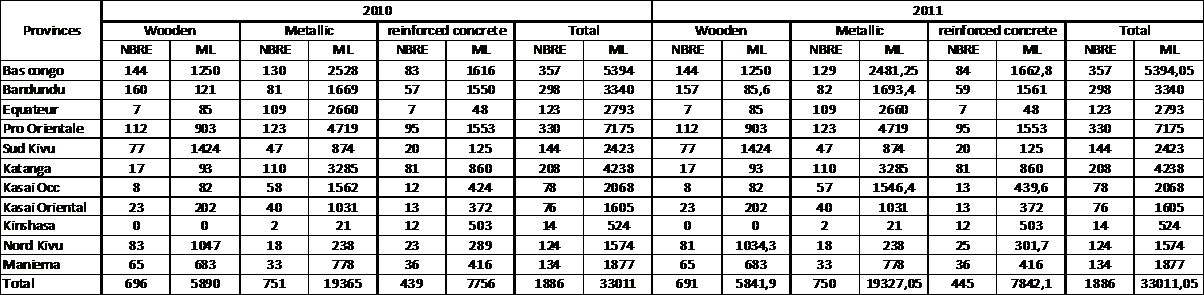
Distribution of bridges by provinces and types (Source: Office des Routes: Rapport Annuel D’activités – Exercise 2011)
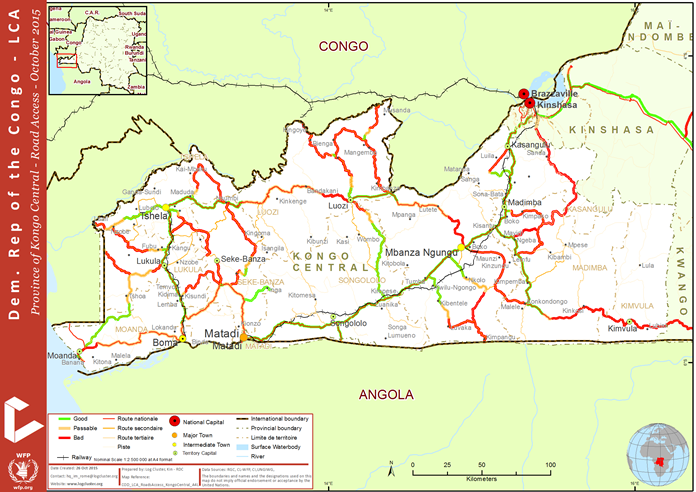
Kongo Central Province (ex Bas Congo)
Below is the map of the main road network in Kongo Central Province.
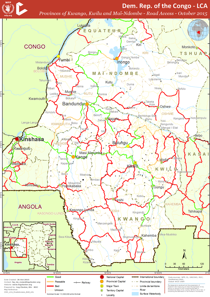
Maï-Ndombe, Kwilu and Kwango Provinces (ex Bandundu)
Below is the map of the main road networks in Maï-Ndombe, Kwilu and Kwango Provinces.
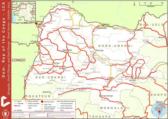
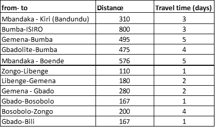
North Ubangui, South Ubangui and Mongala Provinces (parts of ex Equateur)
Below is the map of the main road networks in North Ubangui, South Ubangui and Mongala Provinces.
Distances by road:
More distances can be found in this Road Matrix.
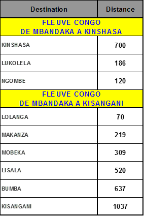
Distances by boat:
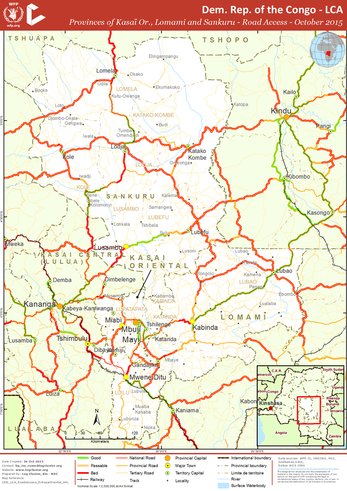
Kasaï Oriental, Lomami and Sankuru Provinces (ex Kasaï Occidental)
Below is the map of the main road networks in Kasaï Oriental, Lomami and Sankuru Provinces.
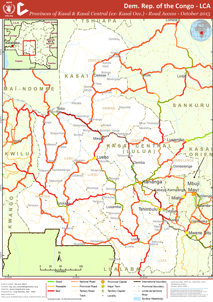
Kasaï and Kasaï Central Provinces (ex Kasaï Oriental)
Below is the map of the main road networks in Kasaï and Kasaï Central Provinces.
Tanganyka Province (part of ex Katanga)
The capital of this province, Kalémie, is now better connected to the North (Bukavu) and the South (Pweto then Lubumbashi) through some well-built roads (especially between Pweto and Lubumbashi). However, the rest of the road network is difficult and can be seriously affected by the weather conditions.
Below is the map of the main road network in Tanganyka Province.
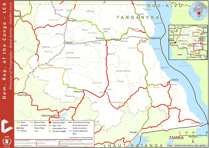
Distances can be found in this Road Matrix of all ex Katanga Province.
Haut Katanga Province (part of ex Katanga)
Distances for all destinations in ex Katanga Province from Lubumbashi can be found in this Road Matrix.
KEY INFO
Lubumbashi – Pweto: 2 days by road (487 km)
Lubumbashi – Kalémie: 5 days by road (1,141 km)
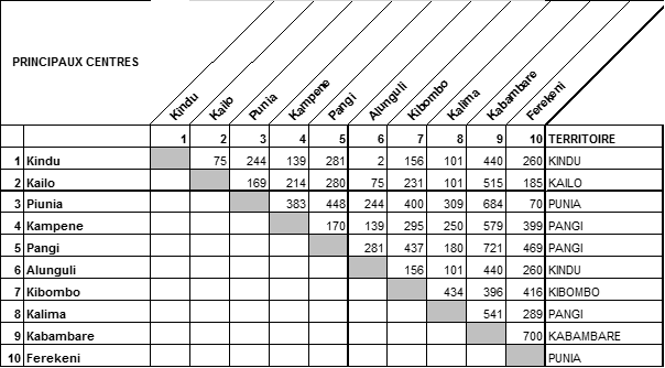
Maniema Province
This province is seriously landlocked as rail solutions are unreliable and roads (especially North and North East) are in a very bad condition.
Below is a Distance Matrix for Maniema Province.
KEY INFO
For now, the only road access to South Kivu Province is a medium size road starting from Kindu, going south to Kasongo, then north-east to the border with South Kivu province, and, in Matala village, finally south-east along the border to Kasikasilu (then you can go north to Fizi or south to Kalémie).
North Kivu Province
Below is the map of the main road network in North Kivu Province.
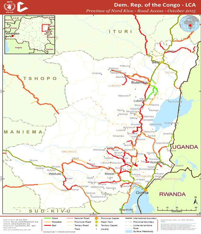
Distances can be found in this Road Matrix of all North Kivu Province.
Tshopo Province (part of ex Province Orientale)
Tshopo Province is considered the central part of the ex Province Orientale as it is a key region linking the West and East of DRC:
- Kisangani is a hub where the Congo River connects with roads going to Bunia (and Uganda, Kenya) and Goma (and Rwanda, Tanzania).
- From Kisangani, you can also go by river to North West of the ex Equateur Province (then to Bangui, CAR) and Kinshasa.
- You can also go to Maniema, using road or train (both in poor condition), up to Ubundu where you can use a boat to reach Kindu.
Below is the map of the main road network in Tshopo Province.
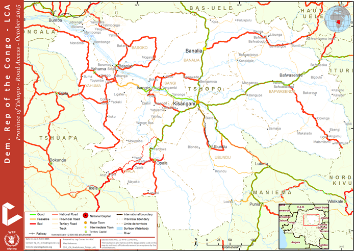
KEY INFO
Kisangani-Gbadolite :
- Kisangani-Bumba : 2 days on Congo river
- Bumba-Gbadolite: 3 days by road (500 km)
Ituri Province (part of ex Province Orientale)
Below is the map of the main road network in Ituri Province.
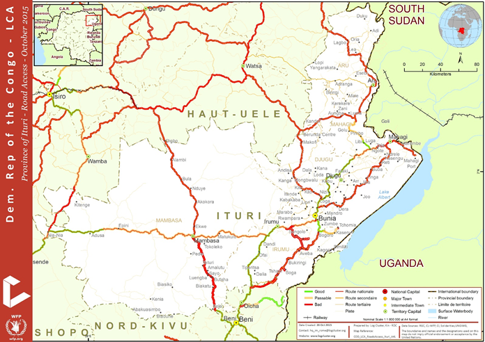
Below is a Distance Matrix for Ituri Province.

KEY INFO
Bunia-Kisangani: 2 days by road (700 km)
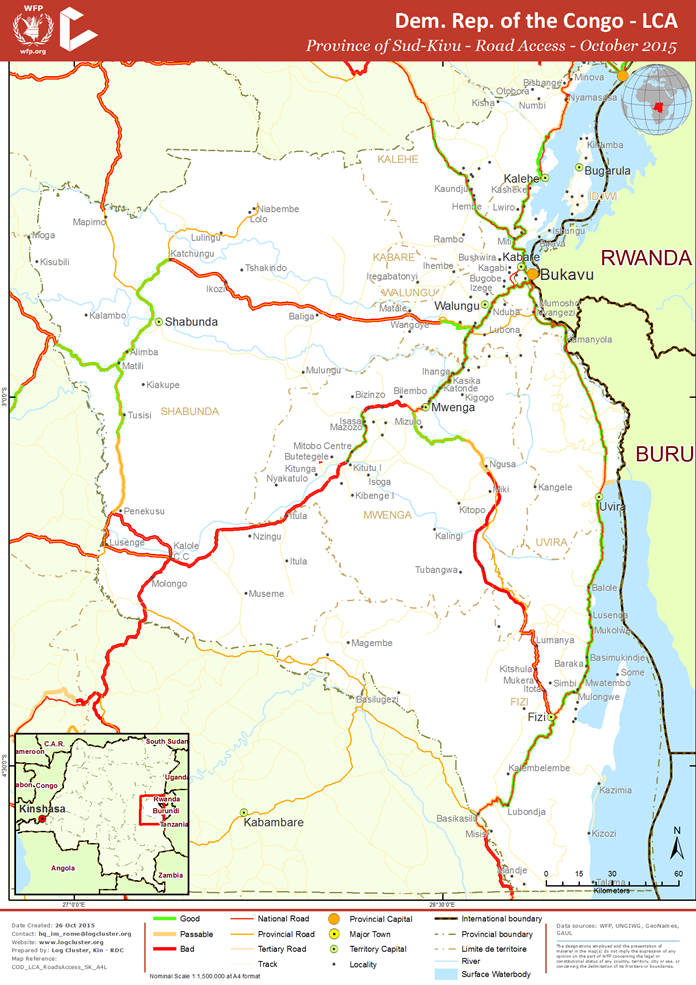
South Kivu Province
The province of South Kivu has a road network consists mainly of dirt roads with the exception of the paved road of the Ruzizi plain.
Below is the map of the main road network in Ituri Province.
Road Corridor Assessment
International Corridors Leading to the Country
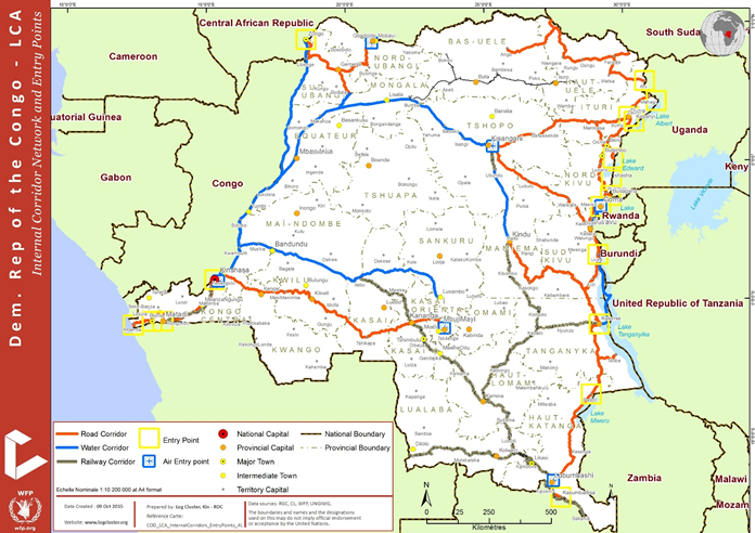
Because of its special geographic configuration, DRC is a semi landlocked country with only 32 km of coastline. The remaining part of the country is opened outward through corridors that connect it to international trade.
These corridors are the only entry points for goods for this part of the country.
There are several international corridors, here gathered in 3 zones, linking the DRC to other countries:
- On the Eastern borders of DRC: The Northern Corridor and the Central Corridor
- The Southern borders of DRC
- The Western borders of DRC
1. Eastern Borders
Below is an overview map of the Eastern borders.
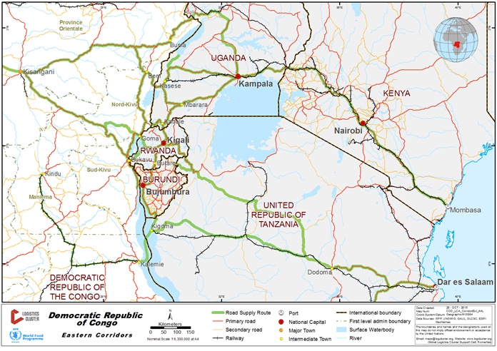
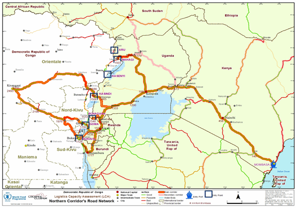
The Northern Corridor
The Northern Corridor is the transport corridor linking the landlocked countries of Uganda, Rwanda and Burundi with Kenya’s maritime port of Mombasa. Similarly, the Northern Corridor serves Eastern part of the Democratic Republic of Congo, Southern Sudan and Northern Tanzania. Thus, the Northern Corridor infrastructure connects all the five countries of the East African Community and beyond.
It is the busiest and most important transport route in East and Central Africa. It totals about 7,000 km, of which 60% is paved and 40% is unpaved, as depicted in the table below:
(Source: Northern Corridor Transit and Transport Coordination Authority)
Below is a map of the Northern Corridor.
Because of their heavy reliance of the Northern Corridor for their overseas trade, as well as the trade among themselves, Burundi, Democratic Republic of Congo, Kenya, Rwanda and Uganda are contracting parties to the Northern Corridor Agreement.
The Agreement provides the legal framework for collaboration among these countries on matters related to transit transport; customs control; documentation and procedures; as well as the development of infrastructure and facilities relating to sea ports, inland ports and waterways, roads, railways, pipelines and border posts.
The Northern Corridor is a multi-modal corridor, encompassing road, rail, pipeline and inland waterways transport. The main road network runs from Mombasa Sea Port through Kenya and Uganda to Kigali in Rwanda, Bujumbura in Burundi and to Kisangani in the Democratic Republic of Congo.
The road network also links Kenya and Uganda to Juba in South Sudan. The rail network runs from Mombasa Sea Port through Nairobi, Malaba, and Kampala to Kasese in Western Uganda, close to the border with the Democratic Republic of Congo. A branch line radiates from Nakuru to Kisumu on Lake Victoria, from where rail wagon ferries link the system to Port Bell in Kampala.
Another rail branch line runs from Tororo in eastern Uganda to Pakwach in northern Uganda. River steamers are used to provide links with Nimule in South Sudan from Pakwach. The oil pipeline runs from Mombasa through Nairobi and Nakuru to Kisumu and Eldoret in western Kenya, from where the landlocked countries access their fuel imports. (Source: Northern Corridor Transit and Transport Coordination Authority)
The international and intra-regional trade as engine of economic growth in the region is hampered by high costs of doing business, including:
- High costs of transport and delays;
- Numerous NTBs (non-traffic barriers) and associated administrative costs along the transit chain;
- Lack of implementation by Member States of various protocols on trade and transport facilitation;
- Low level of awareness of laws, regulations and agreements/conventions;
- Lack of facilitation mindset;
- Limited capacity to package bankable projects.
The whole related costs are allocated gradually to the landlocked Member States.
The Region is a net importer and very uncompetitive compared to other economies:
- 37% of the total logistics costs in landlocked Northern Corridor Member States are attributable to road transport costs;
- Direct costs of delay contributed to more than 2% of the total logistics costs;
- Hidden costs of delays constitute 40% of the total logistics costs ;
- Delays on the northern transport corridor is estimated to cause a loss of an estimated $800 per day per truck, hence increasing the cost of doing business in the region (Source: Transit and Trade Facilitation along the Northern Corridor: Challenges, Experiences Towards an Enhanced Sustainable Partnership).
The estimated delivery leadtime in the Northen Corridor is outlined in the table below. (Source: WFP DRC Logistics)
|
ORIGIN |
DESTINATION |
DISTANCE (Km / NM) |
MODE OF TRANSPORT |
LEAD TIME (days) |
|---|---|---|---|---|
|
Transport |
||||
|
Mombasa |
Tororo |
937 |
Road |
10-12 |
|
|
|
|
Rail |
12-20 |
|
Mombasa |
Kampala |
1,148 |
Road |
15 |
|
|
|
|
Rail |
14-30 |
|
Mombasa |
Kigali |
1,670 |
Road |
10 |
|
Mombasa |
Goma |
1,766 |
Road |
15-20 |
|
Tororo |
Kampala |
211 |
Road |
1 |
|
Tororo |
Goma |
829 |
Road |
5 |
|
Tororo |
Bunia |
690 |
Road / Lake |
3 |
|
Tororo |
Beni |
785 |
Road |
4 |
|
Tororo |
Bukavu |
1,093 |
Road |
5 |
|
Kampala |
Goma |
618 |
Road |
4 |
|
Kampala |
Bunia |
479 |
Road / Lake |
3 |
|
Kampala |
Mahagi |
560 |
Road |
3 |
|
Kampala |
Beni |
574 |
Road |
3 |
|
Kampala |
Bukavu |
872 |
Road |
5 |
|
Kampala |
Kigali |
522 |
Road |
5 |
|
Kampala |
Kigoma |
1,064 |
Road |
14 |
|
Goma |
Bukavu |
90 |
Lake |
1 - 2 |
|
Goma |
Beni |
400 |
Road |
2 -3 |
|
Goma |
Kindu |
214 |
Air |
1 |
|
Kindu Aéro |
Kindu WFP WH |
5 |
Road |
1 |
|
Goma |
Kalemie |
253 |
Air |
1 |
|
Goma WH |
Goma Port |
7 |
Road |
1 |
|
Beni |
Bunia |
200 |
Road |
1 |
|
Goma |
Bunia |
600 |
Road |
3 - 4 |
|
Kigali |
Goma |
167 |
Road |
1 |
|
Kigali |
Bukavu |
350 |
Road |
1 |
The Central Corridor
The Central Corridor is managed by the Central Corridor Transit Transport Facilitation Agency (TTFA). The TTFA is a multilateral agency formed by five Member States (Burundi, DRC, Rwanda, Tanzania and Uganda) with cooperation from both public and private sector stakeholders.
Transit routes cover cargo and passenger transport utilizing:
- All Tanzanian roads connecting to Burundi, Democratic Republic of Congo, Rwanda and Uganda together with all roads and railway systems in these landlocked countries connecting to the central corridor;
- The Port of Dar es Salaam;
- The Railway system operated by Tanzania Railways Corporation;
- Isaka Dry Port;
- The freight and marine services provided by Uganda Railways Corporation and Marine Services Company Limited respectively and other private companies on Lake Victoria;
- The Port of Mwanza, Kemondo Bay, Port Bell and Jinja Port;
- The marine services provided by Marine Services Company Limited and other public and private Companies on lake Tanganyika;
- The Port of Kigoma, Bujumbura, Moba, Baraka, Kasanga, Kalundu and Kalemie;
- Deep sea and coastal shipping services calling at Dar es Salaam port;
- Kidatu inland trans-shipment terminal and other transit routes and facilities as determined from time to time
(Source: Central Corridor Transit Transport Facilitation Agency)
Below is a map of the Central Corridor.
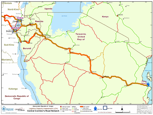
The main challenges of the Central Corridor are related to border and customs procedures, infrastructure, inland non-traffic barriers such as police road blocks, weigh bridges and revenue check points as well as domestic non-traffic barriers that impede the smooth flow of trade.
The estimated delivery leadtime in the Central Corridor is outlined in the table below. (Source: WFP DRC Logistics)
|
ORIGIN |
DESTINATION |
DISTANCE (Km / NM) |
MODE OF TRANSPORT |
LEAD TIME (days) |
|---|---|---|---|---|
|
Transport |
||||
|
Dar-es-Salam |
Kigoma |
1,300 |
Road |
9 |
|
Dar-es-Salam |
Kigali |
1,497 |
Road |
9 |
|
Dar-es-Salam |
Bukavu |
1,638 |
Road |
9 |
|
Dar-es-Salam |
Goma |
1,722 |
Road |
10 |
|
Dar-es-Salam |
Bunia |
2,498 |
Road |
21 |
|
Kigoma |
Kalemie |
n/a |
Lake |
1 |
|
Kigoma |
Uvira |
n/a |
Road |
2 |
|
Kigoma |
Uvira |
n/a |
Lake |
2 |
|
Uvira |
Bukavu |
128 |
Road |
1 |
|
Uvira |
Kalemie |
n/a |
Lake |
2 |
|
Kalemie Port |
Kalemie WFP WH |
3 |
Road |
1 |
|
Bukavu |
Kindu |
178 |
Air |
1 |
|
Bukavu |
Kalemie |
216 |
Air |
1 |
|
Bukavu |
Goma |
90 |
Lake |
1-2 |
|
Bujumbura |
Uvira |
16 |
Road |
1 |
2. Southern borders
The Southern Corridor accounts for a significant percentage of southern DRC export/regional freight. Exporters and importers in Katanga have a variety of options open to them for transporting goods.
They can link up with the Central Corridor and the port of Dar es Salaam or take a variety of routes to Nacal, Beira, Maputo (Mozambique) or through to the port of Durban (South Africa).
Transport corridors in this region are mainly being transformed into integrated economic corridors through the Spatial Development Initiative (SDI).
In order to meet the objectives set by the SDI, there has been been more investment including cargo tracking, tax guarantees (which are used on most of the corridors) and a high percentage of freight containerization.
Below is a map of the Southern Corridor.
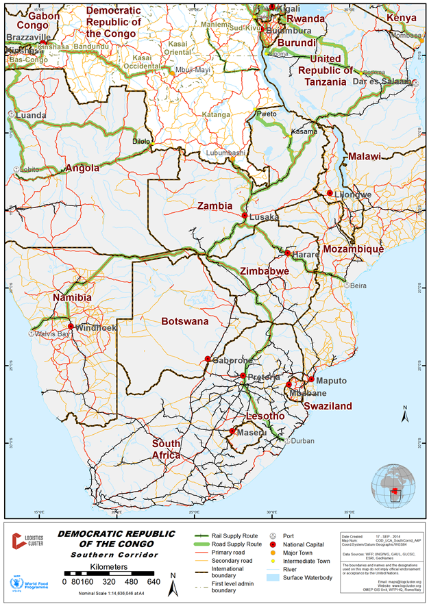
The estimated delivery leadtime in the Southern Corridor is outlined in the table below. (Source: WFP DRC Logistics)
|
ORIGIN |
DESTINATION |
DISTANCE (Km / NM) |
MODE OF TRANSPORT |
LEAD TIME (days) |
|---|---|---|---|---|
|
Transport |
||||
|
Beira |
Lubumbashi |
n/a |
Road / Rail |
39 |
|
Harare |
Lubumbashi |
912 |
Road / Rail |
5 |
|
Lusaka |
Lubumbashi |
539 |
Road / Rail |
15 |
|
Lubumbashi |
Kalemie |
n/a |
Rail / River |
4-8 |
2. Western borders
Below is a map of the Western Corridors.
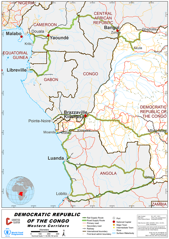
The Equateur region (through Zongo port and/or the Oubangui river) can receive goods through Bangui from three ports abroad:
- The Douala port in Cameroon (congested).
- The Kribi port (new) in Cameroon (a brand new port already partly operational).
- The Libreville port in Gabon (assessed by WFP shipping).
In addition to the Matadi port, there are three other options for transporting goods from the ocean to Kinshasa:
- The Lobito port in Angola.
- The Luanda port in Angola.
- The Pointe Noire port in the Congo Republic.
Main domestic road corridors
Three major economic corridors on which the country’s future development depends can be identified taking into account the distances between key production sectors and their relation to the country’s main infrastructure link.
These are:
- Matadi-Kinshasa-Lubumbashi (road and rail)
- Bunia-Kisangani-Kinshasa (road & river)
- Lubumbashi-Goma (road)
Below is a map of the main domestic road corridors.
- Matadi-Kinshasa-Lubumbashi: This route plays a major role in international trade. The section from Matadi to Kinshasa is the main route for the transport of imports to Kinshasa and for legal exports from the DRC using the Matadi port. The second part between Kinshasa and Lubumbashi can not be yet a major corridor since half of the way is in very bad condition.
- Bunia-Kisangani-Kinshasa: This route is now a major way for transporting goods from eastern Africa to Kinshasa (especially second hand cars from the Middle East or Asia). The Congo River is also crucial for transporting timbers, agricultural products and fish from the center of the country to Kinshasa.
- Lubumbashi-Kalémie-Goma: This route is mainly useful in terms of integrating the country between cities and is also used by the mining industry.
