
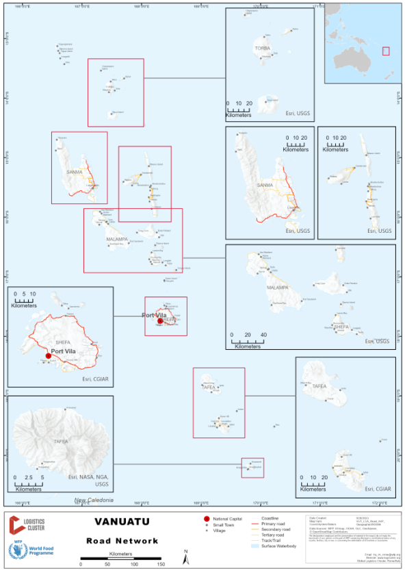
The Public Works Department (PWD), within the Ministry of Infrastructure and Public Utilities, is responsible for the building and maintenance of roads in Vanuatu. The overall road network length managed by PWD is 2,958.6 km. This includes feeder and arterial roads (feeder = 1,704.3 km, arterial = 1,254.3 km). The actual road network length is not known as there are many gravel and earth roads on the islands which are not maintained by PWD. Total roads declared as at 28 August 2023 is 2,906.2 km.
Find below status of roads on the following major islands:
Efate – sealed ring road around the island. Within Shefa Province, all bridges are currently working.
Espiritu Santo – sealed road from Luganville to Port Olry.
Tanna – gravel road from Whitegrass International Airport to Green Hill in the north, sealed roads from Lenakel to Imaki in the south and Lenakel to Snake Hill in the east.
Malekula – sealed road from Norsup to Pushman’s Bay (central part of island).
Pentecost – the roads, particularly to the north, can be impassable after persistent heavy rain. There are numerous ports along the west coast to enable supplies to reach villages.
Service delivery in rural areas is constrained by expensive and limited transport infrastructure and transport services. Rural road infrastructure is impacted during tropical cyclone and heavy rain events and the resulting poor road conditions drive up transport costs, hindering access to much needed services.
For more information on government contact details, please see the following link: 4.1 Government Contact List.
Distance Matrix
|
Travel Time in Major Towns |
|
|---|---|
|
City / Town |
Road and travel time |
|
Port Vila |
Efate Ring Road – 1.5 hours |
|
Luganville |
Luganville to Port Olry – 1 hour |
|
Tanna |
Lenakel to Imaki in the south – 1 hour Lenakel to Snake hill in the east – 30 minutes |
Road Security
The maximum speed limit is 50 km per hour around the towns and 80 km per hour outside town areas.
In Vanuatu, traffic drives on the right-hand side of the road, i.e. people drive in the right-hand lane and overtake on the left. Oncoming traffic comes toward you on the left side.
There are no issues with civil unrest in Vanuatu. Roads can be slippery and flooded during the wet season. Some roads can be impassable after heavy rain events.
Weighbridges and Axle Load Limits
There are no weighbridges in Vanuatu.
Road Class and Surface Conditions
Road Class and Surface Conditions
(FOLLOWING INFORMATION FROM 2017)
The following table depicts the length (km), types and condition of roads in each province:
|
Province |
Sealed |
Gravel |
Earth |
Total |
% Total |
|
Malampa |
0 |
150.13 |
256.8 |
406.9 |
20% |
|
Penama |
0 |
74.3 |
280.9 |
355.2 |
17% |
|
Sanma |
68 |
353.93 |
101.5 |
523.4 |
26% |
|
Shefa |
130.05 |
61.5 |
164.5 |
356.0 |
17% |
|
Tafea |
0.3 |
81.664 |
261.5 |
343.5 |
17% |
|
Torba |
0 |
42.2 |
9.4 |
51.6 |
3% |
|
Total |
198.4 |
763.7 |
1074.6 |
2036.7 |
100% |
The two most populated islands have sealed roads.
Efate has a sealed ring road around the island.
Santo was sealed from Luganville to Port Olry, which has more than halved the travel time to the tourist destination.
In Tanna, CCECC is currently working on gravelling and sealing the roads from Lenekel to the North until Green, South until Imaki, and to the East until Snake Hill. The work is slow going due to the terrain and wet season. After TC Cook (2017) the road to the North was impassable, and the port of Kwamera was unreachable, where road works had not been conducted yet.
In Malekula, the R4D improved the road from Norsup to Lamap in Malekula as part of phase one of the project. It was identified that it would need more gravel in order for it to be maintained.
CCECC offered a loan to seal the road, however the project has been unsuccessful and worsened road conditions. They are almost impassable in sections during the wet season and 4WDs must be used. After TC Cook the Norsup airport could not be reached from the south.
It is understood that CCEECC has halted the project in Malekula and it is unclear if the roads will be left unsealed in its current condition. This means access from the main airport to the major ports and communities in Malekula is extremely slow and difficult.
The roads in Pentecost, particularly to the North, can be impassable after persistent heavy rains. There are numerous ports along the west coast to enable supplies to reach villages.
