
Overview
Transport plays a critical role in Fiji’s economy contributing around 10-12% of GDP. It also employs a considerable amount of people in both formal and informal sectors with the latter most vibrant in the land transport industry. It also links key social and economic sectors of the economy including resources-based industries, education and health.
Because Fiji is prone to disruptive natural events such as tropical cyclones and resultant flooding, its topography has restricted the 7,500-kilometer road network to spine or circumferential main roads with feeder roads, leaving few route alternatives. The Fiji Roads Authority has established a dashboard which shows the status of roads during heavy rain events and cyclones. In the main urban areas, lower-level municipal roads are neglected, rough, and sometimes impassable. Inter-island freight and passenger transport relies on serviceable coastal and island jetties, adequate navigation aids, and reliable and safe domestic shipping services. Smaller jetties have been fairly neglected for many years and are in poor condition.
Fiji’s government has undergone a massive road infrastructure improvement program and reformation of the government road transport management authorities and departments. Prior to reform in January 2012, there were 15 bodies responsible for Fiji’s roads. It was then that the Department of National Roads (DNR) was dissolved, and the Fiji Roads Authority (FRA) was established.
The Land Transport Authority of Fiji is responsible for vehicle and driver licensing and registration while the FRA is responsible for the road infrastructure. Fiji’s road infrastructure is naturally most prevalent on the larger islands. Fiji has 7,000 km of roads and over 1,200 bridges and jetties which also fall under its responsibility.
For more information on government contact details, please see the following link: HQ staff will input a link to section 4.1 Government Contact List
Inland Transport Overview
Fiji Islands is one of the few PICs with a land transport system of any scale. Traffic between cities comprises trucks for freight, buses, minibuses, route taxis, and private vehicles. The most heavily trafficked route is the corridor linking the two main ports, Suva and Lautoka. Haulage of containers between the ports and transport of sugarcane are important contributors to traffic problems. Traffic levels outside of Suva and Lautoka are at most times moderately low, but density increases dramatically near the cities of Lautoka and Suva. Traffic near the ports, general road conditions, and heavy vehicle mass limit laws are the main problems facing inland transport of containers. A large proportion of trucks, particularly those hauling containers, are in contravention of mass limit laws.
The King’s Wharf is located near the center of Suva’s central business district, and a large market and bus terminal is adjacent to the port facility. Traffic congestion in and around the King’s Wharf is, thus, surprisingly severe for an urban center the size of Suva. Trucks carrying containers to and from the King’s Wharf must pass through the center of Suva at a very slow pace. At Lautoka Port, the major landside constraint is very slow-moving trucks carrying sugarcane to a sugar plant opposite the main wharf.
General Road Conditions
Increasing peak loadings are occurring from the land bridging of containers between Suva and Lautoka ports. Some ship operators find it more economical to make a single call, usually at Suva, and land bridge Lautoka cargo under bond. This entails both exports and imports, and as many as 200 containers may be involved in any one ship call. Customer preferences on delivery time and limits on free storage time in the ports drive operators to move all the containers in a short period, thus increasing the load carried by road and causing peak loadings.
The most heavily trafficked route is the Suva/Nadi/Lautoka corridor, which is predominantly two-lane bitumen pavement with small four lane divided sections close to the cities. Road surfaces are generally good but showing wear from what appears to be an increasing heavy vehicle load, particularly at the two terminal nodes. Planned maintenance is on-going. Open road limits (80kph) are enforced with visible police presence near village police posts. A speed camera system throughout the main roads has also been installed to further improve driving standards and road safety. Within villages, speed humps further reduce average speed and increase transit times.
Heavy Vehicle Mass Limits and Bridge Load Limits
Current heavy vehicle mass limits cause problems for road transport operators. The Land Transport Act 1998 stipulates the maximum load limit for various heavy vehicles. Most trucks in Fiji carrying containers are ten-wheelers; the mass limit for these trucks under the Act is 32 tonne gross mass. This is insufficient to allow a typical ten-wheel truck to carry a container fully loaded with a dense cargo, such as water. Historically, enforcement of truckload limits has been lax, but this is changing. With improved enforcement, shippers will face the choice of either partly loading containers—which is clearly inefficient—or using larger trucks. However, a significant amount of investment would be needed to upgrade Fiji’s stock of ten-wheeler trucks to prime-movers and semi-trailers. Overweight vehicles are causing major damage to bridge infrastructure. Lack of maintenance has also caused major bridge damage leading to closed lanes in high traffic areas while repairs are undertaken.
Distance Matrix
Distances from Capital City to Major Towns (km) (Kings Road)
|
|
Nadi Airport |
Lautoka |
Ba |
Tavua |
Rakiraki |
Korovou |
Nausori |
Suva |
|---|---|---|---|---|---|---|---|---|
|
Nadi Airport |
|
24 |
62 |
91 |
132 |
239 |
270 |
289 |
|
Lautoka |
24 |
|
38 |
67 |
108 |
215 |
246 |
265 |
|
Ba |
62 |
38 |
|
29 |
70 |
177 |
208 |
227 |
|
Tavua |
91 |
67 |
29 |
|
41 |
148 |
179 |
198 |
|
Rakiraki |
132 |
108 |
70 |
41 |
|
107 |
138 |
157 |
|
Korovou |
239 |
215 |
177 |
148 |
107 |
|
31 |
50 |
|
Nausori |
270 |
246 |
208 |
179 |
138 |
31 |
|
19 |
|
Suva |
289 |
265 |
227 |
198 |
157 |
50 |
19 |
|
Distances from Capital City to Major Towns (km) (Queens Road)
|
|
Suva |
Pacific Harbor |
Korolevu |
Korotogo |
Sigatoka |
Nadi Town |
Nadi Airport |
Lautoka |
|---|---|---|---|---|---|---|---|---|
|
Suva |
|
49 |
96 |
120 |
127 |
183 |
197 |
221 |
|
Pacific Harbor |
49 |
|
47 |
71 |
78 |
139 |
148 |
172 |
|
Korolevu |
96 |
47 |
|
24 |
31 |
92 |
101 |
125 |
|
Korotogo |
120 |
71 |
24 |
|
7 |
68 |
77 |
101 |
|
Sigatoka |
127 |
78 |
31 |
7 |
|
61 |
70 |
94 |
|
Nadi Town |
183 |
139 |
92 |
68 |
61 |
|
9 |
33 |
|
Nadi Airport |
197 |
148 |
101 |
77 |
70 |
9 |
|
24 |
|
Lautoka |
221 |
172 |
125 |
101 |
94 |
33 |
24 |
|
Km in Vanua Levu
|
|
Labasa |
Savusavu |
Nabouwalu |
Loa |
|---|---|---|---|---|
|
Labasa |
|
82 |
138 |
145 |
|
Savusavu |
82 |
|
138 |
64 |
|
Nabouwalu |
138 |
138 |
|
201 |
|
Loa |
145 |
64 |
201 |
|
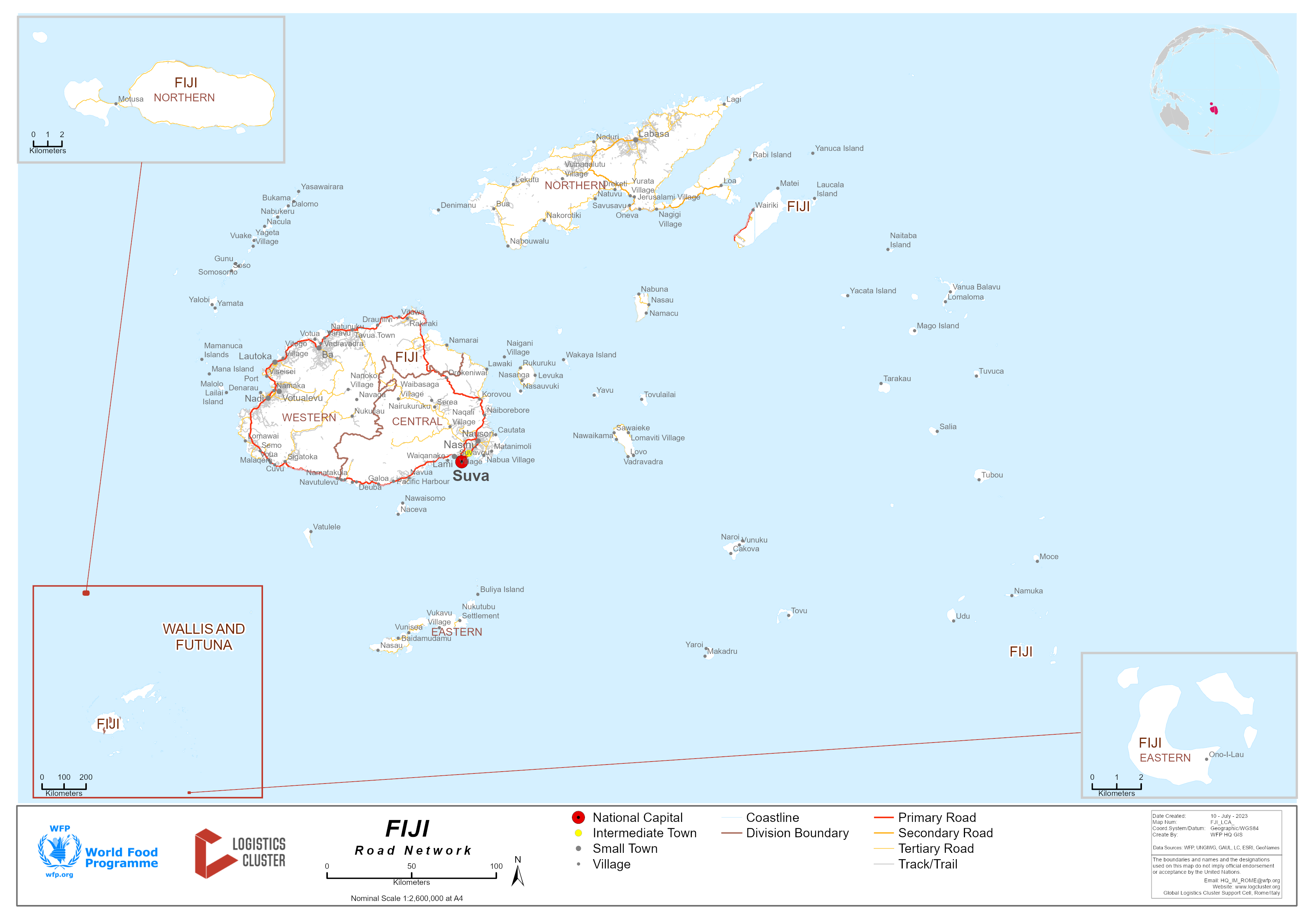
Fiji Bridge Network
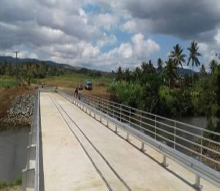
Fiji has between 800-1,000 bridges all in various states of repair. Fiji’s bridge infrastructure investment has seen the replacement of 55 bridges with the future use of Bailey bridges providing further cost-effective improvement in affected areas.
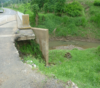
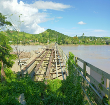
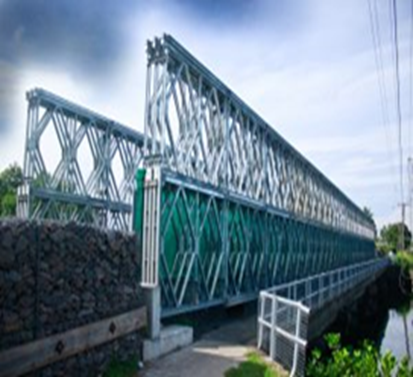
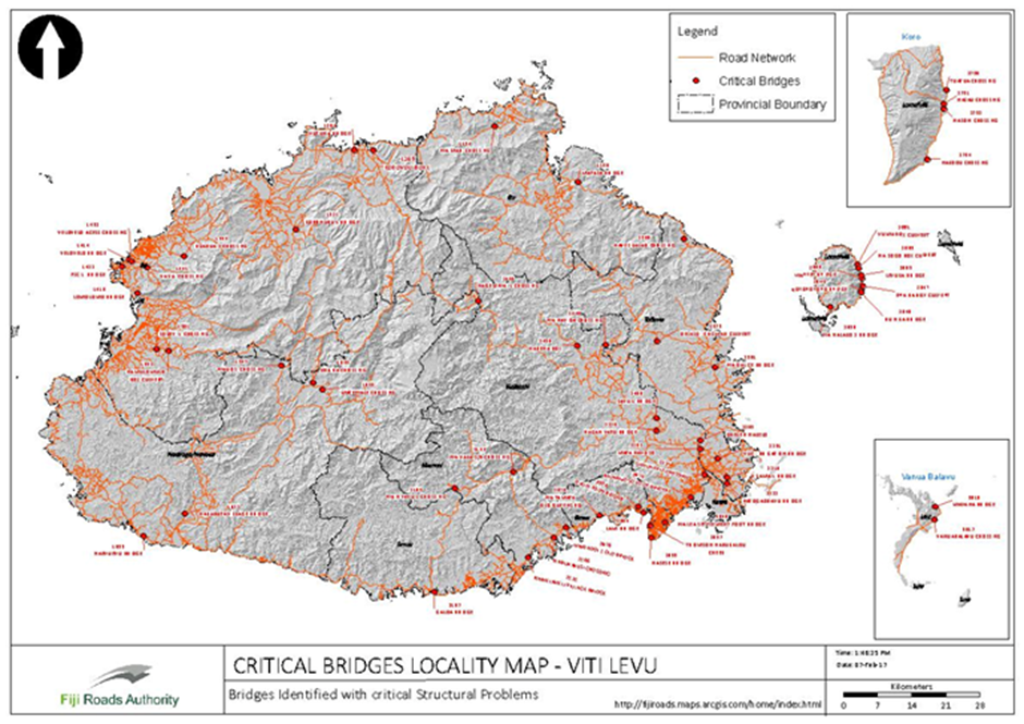
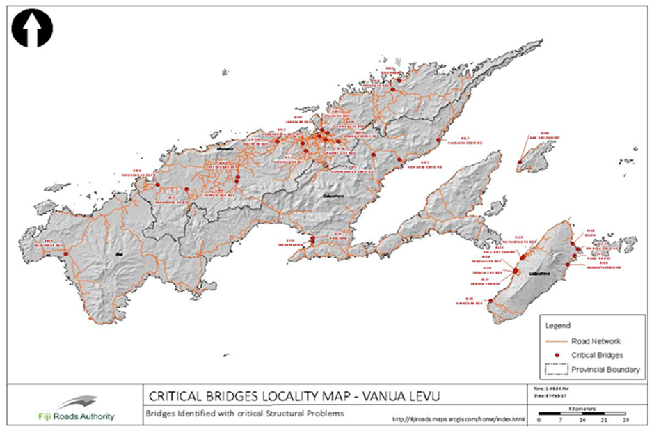
Vulnerable and Critical Bridges
Road Security
There are no road security issues.
Weighbridges and Axle Load Limits
Road Classification
There are 2 main roads in Fiji which connect the most important hubs in Fiji: Suva and Nadi. These are the Queens Road in the South and the Kings Road in the North.
|
Classification |
Description |
|---|---|
|
Paved |
3,440 km |
|
Unpaved |
1,692 km |
Weighbridges
|
Number |
Capacity (MT) |
Length (m) |
Type |
|---|---|---|---|
|
5 |
60 tonne (2 within compound and 3 on major roads) |
11 m |
Axle weighed / weighbridge |
Axle Load Limits
Regulation 80 of (Vehicle Registration and Construction Regulation 2000) states:
The maximum load in respect of any wheel on a vehicle is
-
Fitted with a normal tire – is 2.7 tonnes; or
-
Fitted with a large tire - 3.5 tonnes; or
-
Is the rated capacity of the tire,
-
Whichever is the least?
The maximum axle load in respect of any axle of a vehicle-
-
fitted with two wheels with normal tires – is 5.4 tonnes;
-
fitted with two wheels with large tires is 7 tonnes; and
-
in any other case is 10 tonnes.
The maximum aggregate axle load in respect to a tandem not being a twin axle-
-
fitted with not less than 8 wheels – is 16 tonnes;
-
fitted with 6 wheels with normal tires- is 13.4 tonnes;
-
fitted with 6 wheels with at least two large tires- is 14 tonnes;
-
fitted with 4 wheels with normal tires- is 10.8 tonnes;
-
fitted with 4 wheels with large tires – is 14 tonnes
The maximum aggregate axle load in respect of a tri-axle is 20 tonnes.
The maximum aggregate axle load in respect of twin steer axles is 10.4 tonnes if the twin steer axles are fitted with a load sharing system and 8 tonnes in any other case.
The maximum axle or aggregate load of any axle, tandem or tri-axle must not exceed the aggregate of the rated tire capacities or the vehicle manufacturers rated capacity.
For the purpose of this regulation, a large tire must have-
-
a width of not less than 330mm and an overall tire diameter of not less than 1,080mm; or
-
a width of not less than 355 mm and an overall tire diameter of not less than 1,049mm and a tire not conforming to the dimensions is deemed to be normal tire.
In the case of a vehicle equipped with two single axles, the proportion of weight on one axle must not be less than 20% of the aggregate of the axle weights.
The maximum permissible aggregate mass, expressed as the GVM or GCM of the vehicle, in respect of all the axles of a motor vehicle, a trailer, articulated vehicle or combination vehicle is-
-
the maximum aggregate of the axle loads in respect of all the axles of the vehicle determined under sub regulations (1) to (6);
-
in the case of a vehicle equipped with a tandem or a tri-axle which does not incorporate a load sharing system 30 tonnes or in the case of a vehicle equipped with a tandem or tri-axle which incorporates a load sharing system –32 tonnes;
-
in the case of a combination vehicle- 32 tonnes; or
-
The manufacturers gross vehicle mass or gross combination mass as the case whichever is the least.
In the case of any motor vehicle, trailer or combination vehicle with an unladen mass greater than 3.5 tonnes, the maximum axle loads determined under this regulation must be shown on the registration certificate of the vehicle, including the minimum tire specification relating to such loads.
The FRA is advising members of the public that there is a load restriction on the Lami Bridge of a maximum 8,000 kg individual axle load for all types of vehicles. It is important to note that mobile cranes exceed the axle load limit and are hereby prohibited to cross the bridge.
With prior FRA review, it may be possible for mobile cranes to be transported using a low bed combination vehicle provided that the loading on the axles complies with LTA regulations and is distributed over a long truck configuration. The bridge will be restricted to one-way traffic during any such movements over the bridge.
This restriction does not affect haulage vehicles/trucks that comply with the LTA regulations. Heavy vehicles are requested to cross the bridge one at a time. We have installed signage indicating the weight restriction near the bridge.
The FRA strongly stresses that there is no restriction for any vehicle operating within the current vehicle load criteria; this restriction only applies to heavy vehicles with few axles.
Main existing corridors
-
Nausori–Suva: The bulk of industrial / commercial / transport companies are situated along the Nausori-Suva corridor (20 km)
-
Lautoka – Nadi – Suva: Additional industrial companies (sugar, pine wood, garments) are located in the Western Division (Lautoka, Nadi). The Queens Road (Southern road) is an important land transport corridor as companies frequent Suva Port for their import / export activities.
