4.5 Papua New Guinea Airport Company Contact List
Papua New Guinea TOKUA Airport Details
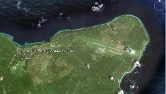
Prior to the 1994 volcanic eruption that destroyed the town of Rabaul, the airport was located at the foot of Tavurvur volcano, near Matupit island. The airport was destroyed by the eruption, and subsequently the new airport was built and opened at Tokua, on the opposite side of the Rabaul caldera.
Details:
- Magnetic Variation 6%30’ E
- Operational Hours: 19.00 till 08.00 UTC
- Fuel Facilities Hours : 19.00 till 08.00 UTC, 7 days
- Fire protection Cat 5, trained personnel: 9
- Navigational Aids: VOR-DME, NDB
- Taxi way and Apron PCN/ 20FCYT
- Lightning: PAPI left side
- CAUTION: Possible Side Wind Shear
Project exist to increase the runway length to 2.100 m
In case of Volcanic Eruption between October and April, high probability of airport closure as dominant wind will lead the ashes in the direction of the airport. Relocation of the airport may be an option for a far future
|
Airport Details |
|||
|---|---|---|---|
|
Country |
Papua New Guinea |
Latitude |
-4.345 |
|
Province / District |
East New Britain Province |
Longitude |
152.4717 |
|
Airport Name |
Tokua Airport |
Elevation (ft) |
28 ft AMSL |
|
IATA & ICAO codes |
RAB & AYTK |
Surface |
Asphalt |
|
Town or City (closest) |
Rabaul 2 km (1mile) |
Runway Condition |
n/a |
|
NGO / UN (on ground) |
n/a |
Passenger / Cargo Security Screening (Yes / No) |
n/a |
|
Runway Dimension |
1,720m x 28m 5,643ft x 92 ft |
Ground Handling (Yes / No) |
n/a |
|
Refueling Capacity |
n/a |
Runway Lighting (Yes / No) |
Yes |
|
Runway Heading |
10/28 |
Fire Fighting Equipment (Yes / No) |
n/a |
|
Air Traffic Control (Yes / No) |
n/a |
Windsock (Yes / No) |
n/a |
|
Weather Information (Yes / No) |
n/a |
Aircraft Parking space (Yes / No) |
n/a |
|
Navigation Aids (Yes / No) |
n/a |
Perimeter fencing (Yes / No) |
n/a |